Bridge Statistics for Rochester, New York (NY)
Condition, Traffic, Stress, Structural Evaluation, Project Costs
- National Bridge Inventory (NBI) Statistics
- 274Number of bridges
- 3,383ft / 1,031mTotal length
- $1,289,899,000Total costs
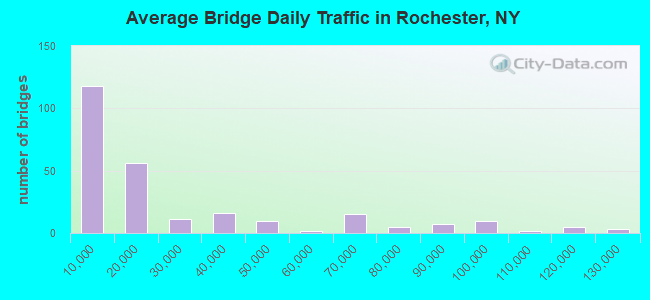
- 6,865,152Total average daily traffic
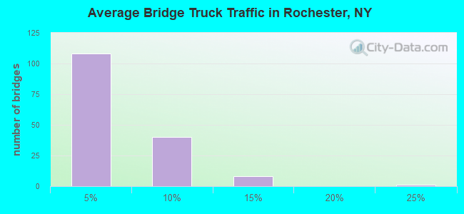
- 99,631Total average daily truck traffic
- National Bridge Inventory (NBI) Registered Bridges for Rochester
- No street view available for this location

- New bridges - historical statistics
- 11Before 1900
- 151900-1909
- 91910-1919
- 41920-1929
- 91930-1939
- 21940-1949
- 251950-1959
- 491960-1969
- 671970-1979
- 261980-1989
- 331990-1999
- 232000-2009
- 12010-2019
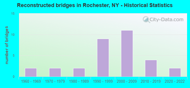
- Reconstructed bridges - Historical Statistics
- 21960-1969
- 21970-1979
- 21980-1989
- 91990-1999
- 112000-2009
- 42010-2019
- 22020-2022
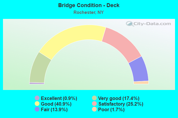
- Bridge Condition - Deck
- 0.9%Excellent
- 17.4%Very good
- 40.9%Good
- 25.2%Satisfactory
- 13.9%Fair
- 1.7%Poor

- Bridge Condition - Superstructure
- 1.7%Excellent
- 15.5%Very good
- 39.7%Good
- 28.4%Satisfactory
- 12.9%Fair
- 1.7%Poor
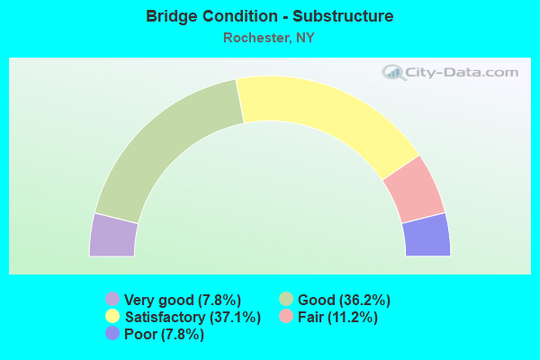
- Bridge Condition - Substructure
- 7.8%Very good
- 36.2%Good
- 37.1%Satisfactory
- 11.2%Fair
- 7.8%Poor
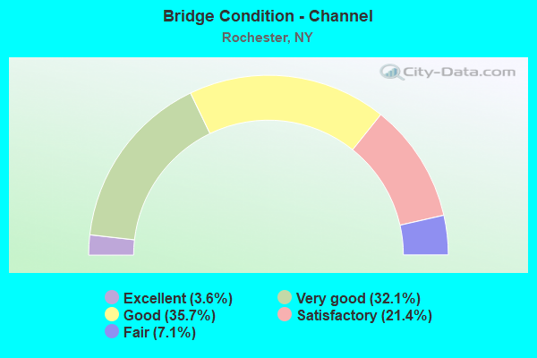
- Bridge Condition - Channel
- 3.6%Excellent
- 32.1%Very good
- 35.7%Good
- 21.4%Satisfactory
- 7.1%Fair
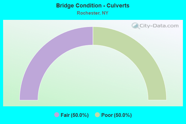
- Bridge Condition - Culverts
- 50.0%Fair
- 50.0%Poor
Find on map >> Show street view
Structure Number: 101482, Location: 2.3MI E JCT RTS 104 & 47 (Lat: 43.199117, Lng: -77.635886), Route carried "on" structure: US 104, Year Built: 1960, Status: Open, Structure Length: 1.86m (6.10ft), Average Daily Traffic: 31,259 (year 2019), Truck Traffic: 3%, Average Future Daily Traffic: 31,405 (year 2040), Design Load: HS 20+Mod, Features Intersected: KODAK PARK RR, KODAK IND
Minimum Vertical Clearance: 30+ m (98+ ft), Kilometerpoint: 30.394, Lanes on structure: 6, Lanes under structure: 2, Base Highway Network: Yes, Owner: State Highway Agency, Approaching Roadway Width: 21.9m (71.9ft), Skew: 21 degrees, Material/Design: Steel, Design/Construction: Stringer/Multi-beam, Number Of Spans In Main Unit: 1, Length of Maximum Span: 17.0m (55.8ft), Curb or Sidewalk Widths: Left: 3.8m (12.5ft), Right: 3.8m (12.5ft), Curb-To-Curb Width: 21.9m (71.9ft), Out-to-Out Width: 30.2m (99.1ft)
Condition: Deck: Satisfactory, Superstructure: Good, Substructure: Satisfactory, Operating Rating: 61.7 metric tons, Method Used To Determine Operating Rating: Load Factor (LF), Inventory Rating: 32.7 metric tons, Method Used To Determine Inventory Rating: Load Factor (LF), Structural Evaluation: Equal to present minimum criteria, Deck Geometry: High priority of corrective action, Underclear: High priority of corrective action, Approach Roadway Alignment: Equal to present minimum criteria, Length Of Structure Improvement: 1.85m (6.07ft), Designated Inspection Frequency: Every 24 months, Inspection Date: September 2020, Bridge Improvement Cost: $2,570,000, Roadway Improvement Cost: $1,505,000, Total Project Cost: $4,074,000 ( Estimate for 2021), Deck Structure Type: Concrete Cast-file-Place, Wearing Surface/Protective System: Wearing Surface: Integral Concrete, Deck Protection: Epoxy Coated Reinforcing
Find on map >> Show street view
Structure Number: 101483, Location: JCT RTE 104 + GENESEE R (Lat: 43.192486, Lng: -77.620153), Route carried "on" structure: State highway 104, Year Built: 1931, Year Reconstructed: 1970, Status: Open, Structure Length: 29.63m (97.21ft), Average Daily Traffic: 72,148 (year 2019), Truck Traffic: 3%, Average Future Daily Traffic: 75,257 (year 2040), Design Load: HS 20, Features Intersected: GENESEE RIVER, BRIDGE VI
Minimum Vertical Clearance: 30+ m (98+ ft), Kilometerpoint: 31.729, Lanes on structure: 8, Lanes under structure: 3, Base Highway Network: Yes, Owner: State Highway Agency, Approaching Roadway Width: 9.8m (32.2ft), Skew: 20 degrees, Navigation Control: Yes ( Vertical Clearance: 45.7m (149.9ft), Horizontal Clearance: 24.3m (79.7ft)), Material/Design: Concrete, Design/Construction: Arch - Deck, Number Of Spans In Main Unit: 7, Length of Maximum Span: 91.4m (299.9ft), Curb or Sidewalk Widths: Left: 2.1m (6.9ft), Right: 2.0m (6.6ft), Curb-To-Curb Width: 27.4m (89.9ft), Out-to-Out Width: 32.4m (106.3ft)
Condition: Deck: Satisfactory, Superstructure: Satisfactory, Substructure: Good, Channel: Very good, Operating Rating: 54.4 metric tons, Method Used To Determine Operating Rating: Load Factor (LF), Inventory Rating: 32.7 metric tons, Method Used To Determine Inventory Rating: Load Factor (LF), Structural Evaluation: Equal to present minimum criteria, Deck Geometry: High priority of replacement, Underclear: High priority of corrective action, Waterway Adequacy: Equal to present desirable criteria, Approach Roadway Alignment: Equal to present minimum criteria, Length Of Structure Improvement: 29.62m (97.18ft), Designated Inspection Frequency: Every 24 months, Inspection Date: December 2020, Bridge Improvement Cost: $42,820,000, Roadway Improvement Cost: $25,076,000, Total Project Cost: $67,896,000 ( Estimate for 2021), Deck Structure Type: Concrete Cast-file-Place, Wearing Surface/Protective System: Wearing Surface: Integral Concrete, Deck Protection: Epoxy Coated Reinforcing
Find on map >> Show street view
Structure Number: 102164, Location: JCT S.H.31 & I490 (Lat: 43.142278, Lng: -77.586217), Route carried "on" structure: City street 31, Year Built: 1959, Status: Open, Structure Length: 5.18m (16.99ft), Average Daily Traffic: 10,393 (year 2019), Truck Traffic: 3%, Average Future Daily Traffic: 12,625 (year 2040), Design Load: HS 20+Mod, Features Intersected: 490I490I43022049 EB, RTE
Minimum Vertical Clearance: 30+ m (98+ ft), Kilometerpoint: 38.278, Lanes on structure: 4, Lanes under structure: 6, Base Highway Network: Yes, Owner: State Highway Agency, Approaching Roadway Width: 15.2m (49.9ft), Skew: 4 degrees, Material/Design: Steel, Design/Construction: Stringer/Multi-beam, Number Of Spans In Main Unit: 2, Length of Maximum Span: 24.9m (81.7ft), Curb or Sidewalk Widths: Left: 2.4m (7.9ft), Right: 2.4m (7.9ft), Curb-To-Curb Width: 15.2m (49.9ft), Out-to-Out Width: 20.7m (67.9ft)
Condition: Deck: Fair, Superstructure: Satisfactory, Substructure: Poor, Operating Rating: 88.9 metric tons, Method Used To Determine Operating Rating: Load Factor (LF), Inventory Rating: 52.6 metric tons, Method Used To Determine Inventory Rating: Load Factor (LF), Structural Evaluation: Meets minimum limits, Deck Geometry: High priority of corrective action, Underclear: High priority of corrective action, Approach Roadway Alignment: Equal to present minimum criteria, Length Of Structure Improvement: 5.18m (16.99ft), Designated Inspection Frequency: Every 24 months, Inspection Date: December 2021, Bridge Improvement Cost: $3,621,000, Roadway Improvement Cost: $2,121,000, Total Project Cost: $5,742,000 ( Estimate for 2021), Deck Structure Type: Concrete Cast-file-Place, Wearing Surface/Protective System: Wearing Surface: Monolithic Concrete
Find on map >> Show street view
Structure Number: 102598, Location: .5MI S OF JCT 590I & 490I (Lat: 43.137042, Lng: -77.552997), Route carried "on" structure: City street , Year Built: 1991, Status: Open, Structure Length: 5.39m (17.68ft), Average Daily Traffic: 4,815 (year 2019), Truck Traffic: 2%, Average Future Daily Traffic: 5,957 (year 2040), Design Load: HS 20, Features Intersected: 590I590I43012000 NB, RTE, Facility Carried by Structure: HIGHLAND AVENUE
Minimum Vertical Clearance: 30+ m (98+ ft), Kilometerpoint: 5.133, Lanes on structure: 4, Lanes under structure: 6, Owner: State Highway Agency, Approaching Roadway Width: 14.6m (47.9ft), Material/Design: Prestressed concrete, Design/Construction: Box Beam or Girders - Multiple, Number Of Spans In Main Unit: 2, Length of Maximum Span: 25.9m (85.0ft), Curb or Sidewalk Widths: Left: 1.5m (4.9ft), Right: 1.5m (4.9ft), Curb-To-Curb Width: 14.6m (47.9ft), Out-to-Out Width: 18.3m (60.0ft)
Condition: Deck: Satisfactory, Superstructure: Fair, Substructure: Satisfactory, Operating Rating: 65.3 metric tons, Method Used To Determine Operating Rating: Load Factor (LF), Inventory Rating: 39.0 metric tons, Method Used To Determine Inventory Rating: Load Factor (LF), Structural Evaluation: Somewhat better than minimum adequacy, Deck Geometry: High priority of replacement, Underclear: High priority of corrective action, Approach Roadway Alignment: Equal to present desirable criteria, Length Of Structure Improvement: 5.39m (17.68ft), Designated Inspection Frequency: Every 24 months, Inspection Date: August 2021, Bridge Improvement Cost: $2,054,000, Roadway Improvement Cost: $1,203,000, Total Project Cost: $3,257,000 ( Estimate for 2021), Deck Structure Type: Concrete Cast-file-Place, Wearing Surface/Protective System: Wearing Surface: Bituminous, Membrane: Other, Deck Protection: Epoxy Coated Reinforcing
Find on map >> Show street view
Structure Number: 102606, Location: 0.6MI N JCT ROL+RTE286 (Lat: 43.165839, Lng: -77.538894), Route carried "on" structure: City street , Year Built: 1960, Status: Open, Structure Length: 6.13m (20.11ft), Average Daily Traffic: 106 (year 2017), Truck Traffic: 5%, Average Future Daily Traffic: 148 (year 2037), Design Load: HS 20+Mod, Features Intersected: 590 590 43012006 NB, RTE, Facility Carried by Structure: TRYON PARK
Minimum Vertical Clearance: 30+ m (98+ ft), Kilometerpoint: 0.434, Lanes on structure: 2, Lanes under structure: 6, Owner: State Highway Agency, Approaching Roadway Width: 6.7m (22.0ft), Material/Design: Steel, Design/Construction: Stringer/Multi-beam, Number Of Spans In Main Unit: 4, Length of Maximum Span: 17.9m (58.7ft), Curb or Sidewalk Widths: Left: 1.5m (4.9ft), Right: 1.5m (4.9ft), Curb-To-Curb Width: 6.7m (22.0ft), Out-to-Out Width: 10.4m (34.1ft)
Condition: Deck: Satisfactory, Superstructure: Satisfactory, Substructure: Good, Operating Rating: 69.9 metric tons, Method Used To Determine Operating Rating: Load Factor (LF), Inventory Rating: 41.7 metric tons, Method Used To Determine Inventory Rating: Load Factor (LF), Structural Evaluation: Equal to present minimum criteria, Deck Geometry: Meets minimum limits, Underclear: High priority of corrective action, Approach Roadway Alignment: Equal to present desirable criteria, Length Of Structure Improvement: 6.12m (20.08ft), Designated Inspection Frequency: Every 24 months, Inspection Date: June 2021, Bridge Improvement Cost: $1,528,000, Roadway Improvement Cost: $895,000, Total Project Cost: $2,423,000 ( Estimate for 2021), Deck Structure Type: Concrete Cast-file-Place, Wearing Surface/Protective System: Wearing Surface: Monolithic Concrete, Deck Protection: Other Coated Reinforcing
Find on map >> Show street view
Structure Number: 103597, Location: INTERSEC RTS 390 & LOSP (Lat: 43.269528, Lng: -77.663894), Route carried "on" structure: State highway 390, Year Built: 1958, Status: Open, Structure Length: 4.15m (13.62ft), Average Daily Traffic: 18,662 (year 2020), Truck Traffic: 1%, Average Future Daily Traffic: 19,466 (year 2040), Design Load: H 20, Features Intersected: 947A947A43021197 WB, RTE
Minimum Vertical Clearance: 30+ m (98+ ft), Kilometerpoint: 12.856, Lanes on structure: 2, Lanes under structure: 4, Owner: State Highway Agency, Approaching Roadway Width: 16.5m (54.1ft), Skew: 21 degrees, Material/Design: Concrete, Design/Construction: Slab, Number Of Spans In Main Unit: 2, Length of Maximum Span: 16.2m (53.1ft), Curb or Sidewalk Widths: Left: 0.3m (1.0ft), Right: 0.3m (1.0ft), Curb-To-Curb Width: 16.8m (55.1ft), Out-to-Out Width: 18.3m (60.0ft)
Condition: Deck: Good, Superstructure: Satisfactory, Substructure: Satisfactory, Operating Rating: 56.2 metric tons, Method Used To Determine Operating Rating: Field evaluation and documented engineering judgment, Inventory Rating: 22.8 metric tons, Method Used To Determine Inventory Rating: Field evaluation and documented engineering judgment, Structural Evaluation: Somewhat better than minimum adequacy, Deck Geometry: Superior to present desirable criteria, Underclear: High priority of corrective action, Approach Roadway Alignment: Equal to present desirable criteria, Length Of Structure Improvement: 4.14m (13.58ft), Designated Inspection Frequency: Every 24 months, Inspection Date: May 2021, Bridge Improvement Cost: $3,632,000, Roadway Improvement Cost: $2,127,000, Total Project Cost: $5,759,000 ( Estimate for 2021), Wearing Surface/Protective System: Wearing Surface: Bituminous
Find on map >> Show street view
Structure Number: 1035989, Location: 5.5MI E JCT LOSP+RTE 261 (Lat: 43.265119, Lng: -77.657469), Route carried "on" structure: Other road 947A, Year Built: 1955, Status: Open, Structure Length: 1.68m (5.51ft), Average Daily Traffic: 13,356 (year 2018), Truck Traffic: 1%, Average Future Daily Traffic: 13,931 (year 2040), Design Load: H 20, Features Intersected: ROUND POND CREEK
Minimum Vertical Clearance: 30+ m (98+ ft), Kilometerpoint: 32.421, Lanes on structure: 4, Base Highway Network: Yes, Owner: State Highway Agency, Approaching Roadway Width: 19.5m (64.0ft), Skew: 20 degrees, Material/Design: Concrete, Design/Construction: Culvert, Number Of Spans In Main Unit: 2, Length of Maximum Span: 7.6m (24.9ft), Curb-To-Curb Width: 19.5m (64.0ft), Out-to-Out Width: 34.9m (114.5ft)
Condition: Channel: Fair, Culverts: Poor, Operating Rating: 72.4 metric tons, Method Used To Determine Operating Rating: Field evaluation and documented engineering judgment, Inventory Rating: 31.5 metric tons, Method Used To Determine Inventory Rating: Field evaluation and documented engineering judgment, Structural Evaluation: Meets minimum limits, Deck Geometry: Somewhat better than minimum adequacy, Waterway Adequacy: Equal to present minimum criteria, Approach Roadway Alignment: Equal to present desirable criteria, Length Of Structure Improvement: 1.67m (5.48ft), Designated Inspection Frequency: Every 24 months, Inspection Date: October 2021, Bridge Improvement Cost: $2,029,000, Roadway Improvement Cost: $1,188,000, Total Project Cost: $3,218,000 ( Estimate for 2021)
Find on map >> Show street view
Structure Number: 1035999, Location: 6.1MI E JCT LOSP+RTE 261 (Lat: 43.261633, Lng: -77.646731), Route carried "on" structure: State lands road 947A, Year Built: 1956, Year Reconstructed: 2008, Status: Open, Structure Length: 2.41m (7.91ft), Average Daily Traffic: 13,356 (year 2018), Truck Traffic: 2%, Average Future Daily Traffic: 13,931 (year 2040), Design Load: HS 25 or greater, Features Intersected: DEWEY AVE CR 132
Minimum Vertical Clearance: 99.00m (324.80ft), Kilometerpoint: 33.371, Lanes on structure: 6, Lanes under structure: 2, Base Highway Network: Yes, Owner: State Highway Agency, Approaching Roadway Width: 20.4m (66.9ft), Skew: 21 degrees, Material/Design: Concrete, Design/Construction: Box Beam or Girders - Multiple, Number Of Spans In Main Unit: 1, Length of Maximum Span: 22.9m (75.1ft), Curb-To-Curb Width: 29.1m (95.5ft), Out-to-Out Width: 30.1m (98.8ft)
Condition: Deck: Good, Superstructure: Good, Substructure: Good, Operating Rating: 62.6 metric tons, Method Used To Determine Operating Rating: Load Factor (LF), Inventory Rating: 20.9 metric tons, Method Used To Determine Inventory Rating: Load Factor (LF), Structural Evaluation: Somewhat better than minimum adequacy, Deck Geometry: Better than present minimum criteria, Underclear: Meets minimum limits, Approach Roadway Alignment: Equal to present desirable criteria, Length Of Structure Improvement: 2.40m (7.87ft), Designated Inspection Frequency: Every 24 months, Inspection Date: October 2020, Bridge Improvement Cost: $2,640,000, Roadway Improvement Cost: $1,546,000, Total Project Cost: $4,185,000 ( Estimate for 2021), Deck Structure Type: Concrete Cast-file-Place, Wearing Surface/Protective System: Wearing Surface: Integral Concrete, Deck Protection: Epoxy Coated Reinforcing
Find on map >> Show street view
Structure Number: 103601, Location: 2.0MI E JCT LOSP+NY 390 (Lat: 43.255678, Lng: -77.628317), Route carried "on" structure: County highway , Year Built: 1960, Status: Open, Structure Length: 3.63m (11.91ft), Average Daily Traffic: 4,653 (year 2020), Truck Traffic: 2%, Average Future Daily Traffic: 5,757 (year 2040), Design Load: H 20, Features Intersected: 947A947A43011218 WB, RTE, Facility Carried by Structure: GREENLEAF ROAD
Minimum Vertical Clearance: 30+ m (98+ ft), Kilometerpoint: 0.306, Lanes on structure: 2, Lanes under structure: 4, Owner: State Highway Agency, Approaching Roadway Width: 7.9m (25.9ft), Material/Design: Concrete continuous, Design/Construction: Frame, Number Of Spans In Main Unit: 2, Length of Maximum Span: 16.7m (54.8ft), Curb or Sidewalk Widths: Left: 1.2m (3.9ft), Right: 1.2m (3.9ft), Curb-To-Curb Width: 7.9m (25.9ft), Out-to-Out Width: 11.3m (37.1ft)
Condition: Deck: Satisfactory, Superstructure: Satisfactory, Substructure: Fair, Operating Rating: 60.9 metric tons, Method Used To Determine Operating Rating: Load and Resistance Factor Rating (LRFR) rating reported by rating factor(RF) method using HL-93 loadings, Inventory Rating: 47.0 metric tons, Method Used To Determine Inventory Rating: Load and Resistance Factor Rating (LRFR) rating reported by rating factor(RF) method using HL-93 loadings, Structural Evaluation: Somewhat better than minimum adequacy, Deck Geometry: High priority of corrective action, Underclear: High priority of corrective action, Approach Roadway Alignment: Equal to present desirable criteria, Length Of Structure Improvement: 3.62m (11.88ft), Designated Inspection Frequency: Every 24 months, Inspection Date: April 2021, Bridge Improvement Cost: $1,205,000, Roadway Improvement Cost: $706,000, Total Project Cost: $1,911,000 ( Estimate for 2021), Wearing Surface/Protective System: Wearing Surface: Bituminous
Find on map >> Show street view
Structure Number: 1036469, Location: 3.5MI E Jct Rts 104+386 (Lat: 43.204228, Lng: -77.659106), Route carried "on" structure: US 104, Year Built: 2003, Status: Open, Structure Length: 5.61m (18.41ft), Average Daily Traffic: 31,864 (year 2018), Truck Traffic: 3%, Average Future Daily Traffic: 32,013 (year 2040), Design Load: HS 25 or greater, Features Intersected: 940K 940K43011036 NB, RT
Minimum Vertical Clearance: 99.90m (327.76ft), Kilometerpoint: 28.367, Lanes on structure: 6, Lanes under structure: 4, Base Highway Network: Yes, Owner: State Highway Agency, Approaching Roadway Width: 24.1m (79.1ft), Skew: 21 degrees, Material/Design: Steel continuous, Design/Construction: Stringer/Multi-beam, Number Of Spans In Main Unit: 2, Length of Maximum Span: 27.0m (88.6ft), Curb or Sidewalk Widths: Left: 1.5m (4.9ft), Right: 1.5m (4.9ft), Curb-To-Curb Width: 24.0m (78.7ft), Out-to-Out Width: 31.6m (103.7ft)
Condition: Deck: Good, Superstructure: Excellent, Substructure: Very good, Operating Rating: 70.8 metric tons, Method Used To Determine Operating Rating: Load Factor (LF), Inventory Rating: 42.6 metric tons, Method Used To Determine Inventory Rating: Load Factor (LF), Structural Evaluation: Equal to present desirable criteria, Deck Geometry: Somewhat better than minimum adequacy, Underclear: High priority of corrective action, Approach Roadway Alignment: Equal to present desirable criteria, Length Of Structure Improvement: 5.60m (18.37ft), Designated Inspection Frequency: Every 24 months, Inspection Date: December 2021, Bridge Improvement Cost: $4,428,000, Roadway Improvement Cost: $2,593,000, Total Project Cost: $7,021,000 ( Estimate for 2021), Deck Structure Type: Concrete Cast-file-Place, Wearing Surface/Protective System: Wearing Surface: Integral Concrete, Deck Protection: Epoxy Coated Reinforcing
Find on map >> Show street view
Structure Number: 1048729, Location: JCT I490 & MT READ BLVD (Lat: 43.157214, Lng: -77.659417), Route carried "on" structure: Interstate 490, Year Built: 2009, Status: Open, Structure Length: 3.84m (12.60ft), Average Daily Traffic: 66,335 (year 2019), Truck Traffic: 5%, Average Future Daily Traffic: 92,252 (year 2040), Design Load: HS 25 or greater, Features Intersected: 940K940K43011004, Ramp t
Minimum Vertical Clearance: 30+ m (98+ ft), Kilometerpoint: 30.201, Lanes on structure: 3, Lanes under structure: 11, Base Highway Network: Yes, Owner: State Highway Agency, Approaching Roadway Width: 16.2m (53.1ft), Material/Design: Steel, Design/Construction: Stringer/Multi-beam, Number Of Spans In Main Unit: 1, Length of Maximum Span: 38.0m (124.7ft), Curb-To-Curb Width: 16.2m (53.1ft), Out-to-Out Width: 17.1m (56.1ft)
Condition: Deck: Very good, Superstructure: Very good, Substructure: Very good, Operating Rating: 54.8 metric tons, Method Used To Determine Operating Rating: Load and Resistance Factor Rating (LRFR) rating reported by rating factor(RF) method using HL-93 loadings, Inventory Rating: 42.1 metric tons, Method Used To Determine Inventory Rating: Load and Resistance Factor Rating (LRFR) rating reported by rating factor(RF) method using HL-93 loadings, Structural Evaluation: Equal to present desirable criteria, Deck Geometry: Equal to present minimum criteria, Underclear: High priority of corrective action, Approach Roadway Alignment: Equal to present desirable criteria, Length Of Structure Improvement: 3.84m (12.60ft), Designated Inspection Frequency: Every 24 months, Inspection Date: December 2021, Bridge Improvement Cost: $4,297,000, Roadway Improvement Cost: $2,516,000, Total Project Cost: $6,813,000 ( Estimate for 2021), Deck Structure Type: Concrete Cast-file-Place, Wearing Surface/Protective System: Wearing Surface: Integral Concrete, Deck Protection: Epoxy Coated Reinforcing
Find on map >> Show street view
Structure Number: 104876, Location: 0.5MI W JCT GOODMAN& I490 (Lat: 43.146356, Lng: -77.601031), Route carried "on" structure: City street , Year Built: 1959, Status: Open, Structure Length: 5.00m (16.40ft), Average Daily Traffic: 6,383 (year 2020), Truck Traffic: 2%, Average Future Daily Traffic: 7,754 (year 2040), Design Load: HS 20+Mod, Features Intersected: 490I490I43022040 WB, RTE, Facility Carried by Structure: ALEXANDER STREET
Minimum Vertical Clearance: 30+ m (98+ ft), Kilometerpoint: 0.676, Lanes on structure: 2, Lanes under structure: 8, Owner: State Highway Agency, Approaching Roadway Width: 9.4m (30.8ft), Material/Design: Steel continuous, Design/Construction: Stringer/Multi-beam, Number Of Spans In Main Unit: 2, Length of Maximum Span: 27.4m (89.9ft), Curb or Sidewalk Widths: Left: 2.4m (7.9ft), Right: 2.4m (7.9ft), Curb-To-Curb Width: 12.2m (40.0ft), Out-to-Out Width: 17.6m (57.7ft)
Condition: Deck: Fair, Superstructure: Satisfactory, Substructure: Fair, Operating Rating: 93.4 metric tons, Method Used To Determine Operating Rating: Load Factor (LF), Inventory Rating: 55.3 metric tons, Method Used To Determine Inventory Rating: Load Factor (LF), Structural Evaluation: Somewhat better than minimum adequacy, Deck Geometry: Somewhat better than minimum adequacy, Underclear: High priority of corrective action, Approach Roadway Alignment: Equal to present minimum criteria, Length Of Structure Improvement: 4.99m (16.37ft), Designated Inspection Frequency: Every 24 months, Inspection Date: December 2021, Bridge Improvement Cost: $2,720,000, Roadway Improvement Cost: $1,593,000, Total Project Cost: $4,313,000 ( Estimate for 2021), Deck Structure Type: Concrete Cast-file-Place, Wearing Surface/Protective System: Wearing Surface: Bituminous
Find on map >> Show street view
Structure Number: 104877, Location: JCT I490 EAST + AVERILL (Lat: 43.145169, Lng: -77.600081), Route carried "on" structure: City street , Year Built: 1959, Year Reconstructed: 2020, Status: Open, Structure Length: 5.00m (16.40ft), Average Daily Traffic: 2,118 (year 2017), Truck Traffic: 2%, Average Future Daily Traffic: 2,965 (year 2037), Design Load: HS 20+Mod, Features Intersected: 490I490I43022040 WB, RTE, Facility Carried by Structure: AVERILL AVENUE
Minimum Vertical Clearance: 30+ m (98+ ft), Kilometerpoint: 0.949, Lanes on structure: 2, Lanes under structure: 8, Owner: State Highway Agency, Approaching Roadway Width: 12.2m (40.0ft), Material/Design: Steel continuous, Design/Construction: Stringer/Multi-beam, Number Of Spans In Main Unit: 2, Length of Maximum Span: 27.4m (89.9ft), Curb or Sidewalk Widths: Left: 2.4m (7.9ft), Right: 2.4m (7.9ft), Curb-To-Curb Width: 12.2m (40.0ft), Out-to-Out Width: 17.6m (57.7ft)
Condition: Deck: Satisfactory, Superstructure: Satisfactory, Substructure: Very good, Operating Rating: 85.3 metric tons, Method Used To Determine Operating Rating: Load Factor (LF), Inventory Rating: 50.8 metric tons, Method Used To Determine Inventory Rating: Load Factor (LF), Structural Evaluation: Equal to present minimum criteria, Deck Geometry: Equal to present minimum criteria, Underclear: High priority of corrective action, Approach Roadway Alignment: Equal to present desirable criteria, Length Of Structure Improvement: 4.99m (16.37ft), Designated Inspection Frequency: Every 24 months, Inspection Date: December 2021, Bridge Improvement Cost: $2,698,000, Roadway Improvement Cost: $1,580,000, Total Project Cost: $4,278,000 ( Estimate for 2021), Deck Structure Type: Concrete Cast-file-Place, Wearing Surface/Protective System: Wearing Surface: Monolithic Concrete
Find on map >> Show street view
Structure Number: 104878, Location: JCT I490 EAST +MEIGS ST (Lat: 43.142597, Lng: -77.597456), Route carried "on" structure: City street , Year Built: 1959, Year Reconstructed: 2020, Status: Open, Structure Length: 4.85m (15.91ft), Average Daily Traffic: 4,075 (year 2017), Truck Traffic: 1%, Average Future Daily Traffic: 5,705 (year 2037), Design Load: HS 20+Mod, Features Intersected: 490I490I43022040 WB, RTE, Facility Carried by Structure: MEIGS STREET
Minimum Vertical Clearance: 30+ m (98+ ft), Kilometerpoint: 1.158, Lanes on structure: 2, Lanes under structure: 8, Owner: State Highway Agency, Approaching Roadway Width: 12.2m (40.0ft), Skew: 1 degrees, Material/Design: Steel continuous, Design/Construction: Stringer/Multi-beam, Number Of Spans In Main Unit: 2, Length of Maximum Span: 23.4m (76.8ft), Curb or Sidewalk Widths: Left: 2.4m (7.9ft), Right: 2.4m (7.9ft), Curb-To-Curb Width: 12.2m (40.0ft), Out-to-Out Width: 17.6m (57.7ft)
Condition: Deck: Satisfactory, Superstructure: Good, Substructure: Very good, Operating Rating: 65.3 metric tons, Method Used To Determine Operating Rating: Load Factor (LF), Inventory Rating: 39.0 metric tons, Method Used To Determine Inventory Rating: Load Factor (LF), Structural Evaluation: Better than present minimum criteria, Deck Geometry: Equal to present minimum criteria, Underclear: High priority of corrective action, Approach Roadway Alignment: Equal to present minimum criteria, Length Of Structure Improvement: 4.84m (15.88ft), Designated Inspection Frequency: Every 24 months, Inspection Date: December 2021, Bridge Improvement Cost: $2,621,000, Roadway Improvement Cost: $1,535,000, Total Project Cost: $4,156,000 ( Estimate for 2021), Deck Structure Type: Concrete Cast-file-Place, Wearing Surface/Protective System: Wearing Surface: Bituminous
Find on map >> Show street view
Structure Number: 104879, Location: JCT I490 EAST + GOODMAN (Lat: 43.141811, Lng: -77.594783), Route carried "on" structure: City street , Year Built: 1959, Year Reconstructed: 1988, Status: Open, Structure Length: 3.72m (12.20ft), Average Daily Traffic: 10,917 (year 2020), Truck Traffic: 2%, Average Future Daily Traffic: 13,261 (year 2040), Design Load: HS 20+Mod, Features Intersected: 490I490I43022045 WB, RTE, Facility Carried by Structure: SOUTH GOODMAN ST
Minimum Vertical Clearance: 30+ m (98+ ft), Kilometerpoint: 2.043, Lanes on structure: 4, Lanes under structure: 6, Owner: State Highway Agency, Approaching Roadway Width: 14.6m (47.9ft), Skew: 1 degrees, Material/Design: Steel, Design/Construction: Stringer/Multi-beam, Number Of Spans In Main Unit: 2, Length of Maximum Span: 17.9m (58.7ft), Curb or Sidewalk Widths: Left: 2.4m (7.9ft), Right: 2.4m (7.9ft), Curb-To-Curb Width: 14.6m (47.9ft), Out-to-Out Width: 20.1m (65.9ft)
Condition: Deck: Satisfactory, Superstructure: Good, Substructure: Poor, Operating Rating: 93.4 metric tons, Method Used To Determine Operating Rating: Load Factor (LF), Inventory Rating: 56.2 metric tons, Method Used To Determine Inventory Rating: Load Factor (LF), Structural Evaluation: Meets minimum limits, Deck Geometry: High priority of replacement, Underclear: High priority of corrective action, Approach Roadway Alignment: Equal to present desirable criteria, Length Of Structure Improvement: 3.71m (12.17ft), Designated Inspection Frequency: Every 24 months, Inspection Date: December 2021, Bridge Improvement Cost: $2,552,000, Roadway Improvement Cost: $1,494,000, Total Project Cost: $4,046,000 ( Estimate for 2021), Deck Structure Type: Concrete Cast-file-Place, Wearing Surface/Protective System: Wearing Surface: Integral Concrete, Deck Protection: Epoxy Coated Reinforcing
Find on map >> Show street view
Structure Number: 10488, Location: 2.2MI W JCT I490EAST+441 (Lat: 43.143133, Lng: -77.575275), Route carried "on" structure: City street , Year Built: 1959, Status: Open, Structure Length: 4.21m (13.81ft), Average Daily Traffic: 12,862 (year 2020), Truck Traffic: 2%, Average Future Daily Traffic: 15,624 (year 2040), Design Load: HS 20+Mod, Features Intersected: 490I490I43022055 WB, RTE, Facility Carried by Structure: CULVER ROAD
Minimum Vertical Clearance: 30+ m (98+ ft), Kilometerpoint: 0.644, Lanes on structure: 3, Lanes under structure: 6, Owner: State Highway Agency, Approaching Roadway Width: 12.8m (42.0ft), Skew: 3 degrees, Material/Design: Steel, Design/Construction: Stringer/Multi-beam, Number Of Spans In Main Unit: 2, Length of Maximum Span: 20.1m (65.9ft), Curb or Sidewalk Widths: Left: 2.4m (7.9ft), Right: 2.4m (7.9ft), Curb-To-Curb Width: 12.2m (40.0ft), Out-to-Out Width: 17.6m (57.7ft)
Condition: Deck: Fair, Superstructure: Fair, Substructure: Poor, Operating Rating: 86.2 metric tons, Method Used To Determine Operating Rating: Load Factor (LF), Inventory Rating: 51.7 metric tons, Method Used To Determine Inventory Rating: Load Factor (LF), Structural Evaluation: Meets minimum limits, Deck Geometry: Meets minimum limits, Underclear: High priority of corrective action, Approach Roadway Alignment: Equal to present desirable criteria, Length Of Structure Improvement: 4.20m (13.78ft), Designated Inspection Frequency: Every 24 months, Inspection Date: November 2021, Bridge Improvement Cost: $2,486,000, Roadway Improvement Cost: $1,456,000, Total Project Cost: $3,941,000 ( Estimate for 2021), Deck Structure Type: Concrete Cast-file-Place, Wearing Surface/Protective System: Wearing Surface: Monolithic Concrete
Find on map >> Show street view
Structure Number: 1048829, Location: 1.2MI.W.JCT 490I & 441 (Lat: 43.144581, Lng: -77.555778), Route carried "on" structure: City street , Year Built: 1989, Status: Open, Structure Length: 4.79m (15.72ft), Average Daily Traffic: 10,542 (year 2020), Truck Traffic: 2%, Average Future Daily Traffic: 12,806 (year 2040), Design Load: HS 20, Features Intersected: 490I490I43022065 WB, RTE, Facility Carried by Structure: SOUTH WINTON ROAD
Minimum Vertical Clearance: 30+ m (98+ ft), Kilometerpoint: 0.981, Lanes on structure: 6, Lanes under structure: 8, Owner: State Highway Agency, Approaching Roadway Width: 21.3m (69.9ft), Skew: 2 degrees, Material/Design: Prestressed concrete continuous, Design/Construction: Box Beam or Girders - Multiple, Number Of Spans In Main Unit: 2, Length of Maximum Span: 23.4m (76.8ft), Curb or Sidewalk Widths: Left: 2.4m (7.9ft), Right: 2.4m (7.9ft), Curb-To-Curb Width: 21.3m (69.9ft), Out-to-Out Width: 26.8m (87.9ft)
Condition: Deck: Good, Superstructure: Fair, Substructure: Satisfactory, Operating Rating: 63.5 metric tons, Method Used To Determine Operating Rating: Load Factor (LF), Inventory Rating: 38.1 metric tons, Method Used To Determine Inventory Rating: Load Factor (LF), Structural Evaluation: Somewhat better than minimum adequacy, Deck Geometry: High priority of replacement, Underclear: High priority of corrective action, Approach Roadway Alignment: Equal to present desirable criteria, Length Of Structure Improvement: 4.78m (15.68ft), Designated Inspection Frequency: Every 24 months, Inspection Date: November 2021, Bridge Improvement Cost: $3,568,000, Roadway Improvement Cost: $2,089,000, Total Project Cost: $5,657,000 ( Estimate for 2021), Deck Structure Type: Concrete Cast-file-Place, Wearing Surface/Protective System: Wearing Surface: Bituminous, Membrane: Preformed Fabric, Deck Protection: Epoxy Coated Reinforcing
Find on map >> Show street view
Structure Number: 1049759, Location: .2 MI N JCT MT READ &SH31 (Lat: 43.166919, Lng: -77.659508), Route carried "on" structure: State highway 940K, Year Built: 1954, Year Reconstructed: 2005, Status: Open, Structure Length: 2.07m (6.79ft), Average Daily Traffic: 16,865 (year 2018), Truck Traffic: 9%, Average Future Daily Traffic: 16,944 (year 2040), Design Load: H 20, Features Intersected: CSX FALLS BRANCH
Minimum Vertical Clearance: 30+ m (98+ ft), Kilometerpoint: 1.641, Lanes on structure: 4, Base Highway Network: Yes, Owner: State Highway Agency, Approaching Roadway Width: 17.1m (56.1ft), Skew: 22 degrees, Material/Design: Concrete, Design/Construction: Frame, Number Of Spans In Main Unit: 1, Length of Maximum Span: 18.5m (60.7ft), Curb or Sidewalk Widths: Left: 1.8m (5.9ft), Right: 1.8m (5.9ft), Curb-To-Curb Width: 22.3m (73.2ft), Out-to-Out Width: 31.2m (102.4ft)
Condition: Deck: Satisfactory, Superstructure: Satisfactory, Substructure: Satisfactory, Operating Rating: 56.2 metric tons, Method Used To Determine Operating Rating: Field evaluation and documented engineering judgment, Inventory Rating: 20.3 metric tons, Method Used To Determine Inventory Rating: Field evaluation and documented engineering judgment, Structural Evaluation: Somewhat better than minimum adequacy, Deck Geometry: Superior to present desirable criteria, Underclear: Somewhat better than minimum adequacy, Approach Roadway Alignment: Equal to present desirable criteria, Length Of Structure Improvement: 2.07m (6.79ft), Designated Inspection Frequency: Every 24 months, Inspection Date: October 2020, Bridge Improvement Cost: $3,441,000, Roadway Improvement Cost: $2,015,000, Total Project Cost: $5,457,000 ( Estimate for 2021), Wearing Surface/Protective System: Wearing Surface: Bituminous
Find on map >> Show street view
Structure Number: 104977, Location: 0.7MI S JCT MT READ + 104 (Lat: 43.193911, Lng: -77.659275), Route carried "on" structure: County highway , Year Built: 1954, Year Reconstructed: 1969, Status: Open, Structure Length: 4.21m (13.81ft), Average Daily Traffic: 18,536 (year 2018), Truck Traffic: 2%, Average Future Daily Traffic: 22,517 (year 2040), Design Load: H 20, Features Intersected: 940K940K43011029 SB, RTE, Facility Carried by Structure: RIDGEWAY AVENUE
Minimum Vertical Clearance: 30+ m (98+ ft), Kilometerpoint: 0.499, Lanes on structure: 4, Lanes under structure: 4, Owner: State Highway Agency, Approaching Roadway Width: 13.4m (44.0ft), Material/Design: Steel, Design/Construction: Stringer/Multi-beam, Number Of Spans In Main Unit: 2, Length of Maximum Span: 20.4m (66.9ft), Curb or Sidewalk Widths: Left: 1.9m (6.2ft), Right: 1.9m (6.2ft), Curb-To-Curb Width: 12.2m (40.0ft), Out-to-Out Width: 16.6m (54.5ft)
Condition: Deck: Fair, Superstructure: Satisfactory, Substructure: Satisfactory, Operating Rating: 68.0 metric tons, Method Used To Determine Operating Rating: Load Factor (LF), Inventory Rating: 40.8 metric tons, Method Used To Determine Inventory Rating: Load Factor (LF), Structural Evaluation: Equal to present minimum criteria, Deck Geometry: High priority of replacement, Underclear: High priority of corrective action, Approach Roadway Alignment: Equal to present minimum criteria, Length Of Structure Improvement: 4.20m (13.78ft), Designated Inspection Frequency: Every 24 months, Inspection Date: November 2021, Bridge Improvement Cost: $1,753,000, Roadway Improvement Cost: $1,027,000, Total Project Cost: $2,780,000 ( Estimate for 2021), Deck Structure Type: Concrete Cast-file-Place, Wearing Surface/Protective System: Wearing Surface: Monolithic Concrete
Find on map >> Show street view
Structure Number: 1049789, Location: .5 MI S JCT MT READ&SH104 (Lat: 43.198094, Lng: -77.659267), Route carried "on" structure: Ramp State highway 940K, Year Built: 2006, Status: Open, Structure Length: 2.04m (6.69ft), Average Daily Traffic: 14,853 (year 2018), Truck Traffic: 3%, Average Future Daily Traffic: 14,922 (year 2040), Design Load: HL 93, Features Intersected: KODAK RAILROAD, KODAK SE
Minimum Vertical Clearance: 30+ m (98+ ft), Kilometerpoint: 5.117, Lanes on structure: 6, Lanes under structure: 2, Base Highway Network: Yes, Owner: State Highway Agency, Approaching Roadway Width: 28.0m (91.9ft), Skew: 20 degrees, Material/Design: Steel, Design/Construction: Stringer/Multi-beam, Number Of Spans In Main Unit: 1, Length of Maximum Span: 18.9m (62.0ft), Curb or Sidewalk Widths: Left: 1.9m (6.2ft), Right: 1.9m (6.2ft), Curb-To-Curb Width: 28.3m (92.8ft), Out-to-Out Width: 42.4m (139.1ft)
Condition: Deck: Good, Superstructure: Very good, Substructure: Good, Inventory Rating: 77.1 metric tons, Method Used To Determine Inventory Rating: Load Factor (LF), Structural Evaluation: Better than present minimum criteria, Deck Geometry: Superior to present desirable criteria, Underclear: Meets minimum limits, Approach Roadway Alignment: Equal to present desirable criteria, Length Of Structure Improvement: 2.04m (6.69ft), Designated Inspection Frequency: Every 24 months, Inspection Date: November 2021, Bridge Improvement Cost: $3,977,000, Roadway Improvement Cost: $2,329,000, Total Project Cost: $6,306,000 ( Estimate for 2021), Deck Structure Type: Concrete Cast-file-Place, Wearing Surface/Protective System: Wearing Surface: Monolithic Concrete, Deck Protection: Epoxy Coated Reinforcing
Find on map >> Show street view
Structure Number: 105006, Location: JCT OF NORTH ST&I.L. (Lat: 43.162222, Lng: -77.602469), Route carried "on" structure: City street , Year Built: 1962, Status: Open, Structure Length: 4.33m (14.21ft), Average Daily Traffic: 11,698 (year 2020), Truck Traffic: 5%, Average Future Daily Traffic: 14,210 (year 2040), Design Load: HS 20+Mod, Features Intersected: 940T940T43011011, RTE 94, Facility Carried by Structure: NORTH STREET
Minimum Vertical Clearance: 30+ m (98+ ft), Kilometerpoint: 0.097, Lanes on structure: 4, Lanes under structure: 6, Owner: State Highway Agency, Approaching Roadway Width: 14.6m (47.9ft), Skew: 3 degrees, Material/Design: Steel, Design/Construction: Stringer/Multi-beam, Number Of Spans In Main Unit: 2, Length of Maximum Span: 20.7m (67.9ft), Curb or Sidewalk Widths: Left: 2.4m (7.9ft), Right: 2.4m (7.9ft), Curb-To-Curb Width: 14.6m (47.9ft), Out-to-Out Width: 20.1m (65.9ft)
Condition: Deck: Fair, Superstructure: Satisfactory, Substructure: Poor, Operating Rating: 85.3 metric tons, Method Used To Determine Operating Rating: Load Factor (LF), Inventory Rating: 50.8 metric tons, Method Used To Determine Inventory Rating: Load Factor (LF), Structural Evaluation: Meets minimum limits, Deck Geometry: High priority of replacement, Underclear: Meets minimum limits, Approach Roadway Alignment: Equal to present minimum criteria, Length Of Structure Improvement: 4.32m (14.17ft), Designated Inspection Frequency: Every 24 months, Inspection Date: October 2020, Bridge Improvement Cost: $3,054,000, Roadway Improvement Cost: $1,789,000, Total Project Cost: $4,843,000 ( Estimate for 2021), Deck Structure Type: Concrete Cast-file-Place, Wearing Surface/Protective System: Wearing Surface: Bituminous
Find on map >> Show street view
Structure Number: 105007, Location: 1ST BR.E JCT CLINTON&I.L. (Lat: 43.161500, Lng: -77.607519), Route carried "on" structure: City street , Year Built: 1962, Status: Open, Structure Length: 2.35m (7.71ft), Average Daily Traffic: 9,038 (year 2018), Truck Traffic: 3%, Average Future Daily Traffic: 11,182 (year 2040), Design Load: HS 20+Mod, Features Intersected: 940T940T43011008 WB, RTE, Facility Carried by Structure: JOSEPH AVENUE
Minimum Vertical Clearance: 30+ m (98+ ft), Kilometerpoint: 0.113, Lanes on structure: 3, Lanes under structure: 4, Owner: State Highway Agency, Approaching Roadway Width: 13.4m (44.0ft), Skew: 20 degrees, Material/Design: Steel, Design/Construction: Stringer/Multi-beam, Number Of Spans In Main Unit: 1, Length of Maximum Span: 21.9m (71.9ft), Curb or Sidewalk Widths: Left: 1.2m (3.9ft), Right: 3.0m (9.8ft), Curb-To-Curb Width: 14.6m (47.9ft), Out-to-Out Width: 19.5m (64.0ft)
Condition: Deck: Fair, Superstructure: Satisfactory, Substructure: Fair, Operating Rating: 51.5 metric tons, Method Used To Determine Operating Rating: Load and Resistance Factor Rating (LRFR) rating reported by rating factor(RF) method using HL-93 loadings, Inventory Rating: 39.9 metric tons, Method Used To Determine Inventory Rating: Load and Resistance Factor Rating (LRFR) rating reported by rating factor(RF) method using HL-93 loadings, Structural Evaluation: Somewhat better than minimum adequacy, Deck Geometry: Somewhat better than minimum adequacy, Underclear: Meets minimum limits, Approach Roadway Alignment: Equal to present desirable criteria, Length Of Structure Improvement: 2.34m (7.68ft), Designated Inspection Frequency: Every 24 months, Inspection Date: June 2021, Bridge Improvement Cost: $1,980,000, Roadway Improvement Cost: $1,159,000, Total Project Cost: $3,139,000 ( Estimate for 2021), Deck Structure Type: Concrete Cast-file-Place, Wearing Surface/Protective System: Wearing Surface: Bituminous, Deck Protection: Other Coated Reinforcing
Find on map >> Show street view
Structure Number: 105008, Location: JCT N. CLINTON AVE & I.L. (Lat: 43.161561, Lng: -77.608228), Route carried "on" structure: City street , Year Built: 1962, Status: Open, Structure Length: 2.83m (9.28ft), Average Daily Traffic: 3,986 (year 2020), Truck Traffic: 3%, Average Future Daily Traffic: 4,004 (year 2040), Design Load: HS 20, Features Intersected: 940T940T43011007 WB, RTE, Facility Carried by Structure: N CLINTON AVENUE
Minimum Vertical Clearance: 30+ m (98+ ft), Kilometerpoint: 0.499, Lanes on structure: 3, Lanes under structure: 4, Owner: State Highway Agency, Approaching Roadway Width: 13.4m (44.0ft), Skew: 3 degrees, Material/Design: Steel, Design/Construction: Stringer/Multi-beam, Number Of Spans In Main Unit: 1, Length of Maximum Span: 26.2m (86.0ft), Curb or Sidewalk Widths: Left: 3.0m (9.8ft), Right: 1.2m (3.9ft), Curb-To-Curb Width: 14.6m (47.9ft), Out-to-Out Width: 19.5m (64.0ft)
Condition: Deck: Fair, Superstructure: Satisfactory, Substructure: Fair, Operating Rating: 62.5 metric tons, Method Used To Determine Operating Rating: Load and Resistance Factor Rating (LRFR) rating reported by rating factor(RF) method using HL-93 loadings, Inventory Rating: 48.3 metric tons, Method Used To Determine Inventory Rating: Load and Resistance Factor Rating (LRFR) rating reported by rating factor(RF) method using HL-93 loadings, Structural Evaluation: Somewhat better than minimum adequacy, Deck Geometry: Somewhat better than minimum adequacy, Underclear: Meets minimum limits, Approach Roadway Alignment: Equal to present desirable criteria, Length Of Structure Improvement: 2.83m (9.28ft), Designated Inspection Frequency: Every 24 months, Inspection Date: June 2021, Bridge Improvement Cost: $2,532,000, Roadway Improvement Cost: $1,483,000, Total Project Cost: $4,014,000 ( Estimate for 2021), Deck Structure Type: Concrete Cast-file-Place, Wearing Surface/Protective System: Wearing Surface: Bituminous, Deck Protection: Other Coated Reinforcing
Find on map >> Show street view
Structure Number: 1050099, Location: JCT OF ST PAUL ST&I.L. (Lat: 43.161517, Lng: -77.610617), Route carried "on" structure: City street , Year Built: 1962, Status: Open, Structure Length: 2.44m (8.01ft), Average Daily Traffic: 9,519 (year 2020), Truck Traffic: 3%, Average Future Daily Traffic: 9,563 (year 2040), Design Load: HS 20, Features Intersected: 940T940T43011006, RTE 94, Facility Carried by Structure: ST PAUL STREET
Minimum Vertical Clearance: 30+ m (98+ ft), Kilometerpoint: 0.547, Lanes on structure: 6, Lanes under structure: 4, Owner: State Highway Agency, Approaching Roadway Width: 25.0m (82.0ft), Skew: 1 degrees, Material/Design: Steel, Design/Construction: Stringer/Multi-beam, Number Of Spans In Main Unit: 1, Length of Maximum Span: 23.4m (76.8ft), Curb or Sidewalk Widths: Left: 2.5m (8.2ft), Right: 2.5m (8.2ft), Curb-To-Curb Width: 21.9m (71.9ft), Out-to-Out Width: 30.4m (99.7ft)
Condition: Deck: Poor, Superstructure: Fair, Substructure: Poor, Operating Rating: 64.2 metric tons, Method Used To Determine Operating Rating: Load and Resistance Factor Rating (LRFR) rating reported by rating factor(RF) method using HL-93 loadings, Inventory Rating: 49.2 metric tons, Method Used To Determine Inventory Rating: Load and Resistance Factor Rating (LRFR) rating reported by rating factor(RF) method using HL-93 loadings, Structural Evaluation: Meets minimum limits, Deck Geometry: High priority of corrective action, Underclear: High priority of corrective action, Approach Roadway Alignment: Equal to present minimum criteria, Length Of Structure Improvement: 2.43m (7.97ft), Designated Inspection Frequency: Every 24 months, Inspection Date: September 2020, Bridge Improvement Cost: $3,404,000, Roadway Improvement Cost: $1,993,000, Total Project Cost: $5,397,000 ( Estimate for 2021), Deck Structure Type: Concrete Cast-file-Place, Wearing Surface/Protective System: Wearing Surface: Bituminous
Find on map >> Show street view
Structure Number: 1050109, Location: JCT OF I.L.& GENESEE R (Lat: 43.160717, Lng: -77.612700), Route carried "on" structure: State highway 940T, Year Built: 1963, Year Reconstructed: 2016, Status: Posted for load-capacity, Structure Length: 12.89m (42.29ft), Average Daily Traffic: 43,203 (year 2018), Truck Traffic: 3%, Average Future Daily Traffic: 45,065 (year 2040), Design Load: HS 20+Mod, Features Intersected: BROWNS RACEWAY, GENESEE
Minimum Vertical Clearance: 30+ m (98+ ft), Kilometerpoint: 1.110, Lanes on structure: 6, Base Highway Network: Yes, Owner: State Highway Agency, Approaching Roadway Width: 23.2m (76.1ft), Skew: 23 degrees, Material/Design: Steel, Design/Construction: Stringer/Multi-beam, Number Of Spans In Main Unit: 8, Length of Maximum Span: 17.6m (57.7ft), Curb or Sidewalk Widths: Left: 2.4m (7.9ft), Right: 2.4m (7.9ft), Curb-To-Curb Width: 23.2m (76.1ft), Out-to-Out Width: 29.3m (96.1ft)
Condition: Deck: Satisfactory, Superstructure: Fair, Substructure: Satisfactory, Channel: Good, Operating Rating: 50.8 metric tons, Method Used To Determine Operating Rating: Load Factor (LF), Inventory Rating: 29.9 metric tons, Method Used To Determine Inventory Rating: Load Factor (LF), Structural Evaluation: Somewhat better than minimum adequacy, Deck Geometry: Meets minimum limits, Waterway Adequacy: Equal to present minimum criteria, Approach Roadway Alignment: Equal to present minimum criteria, Length Of Structure Improvement: 12.89m (42.29ft), Designated Inspection Frequency: Every 24 months, Inspection Date: September 2021, Bridge Improvement Cost: $10,092,000, Roadway Improvement Cost: $5,910,000, Total Project Cost: $16,001,000 ( Estimate for 2021), Deck Structure Type: Concrete Cast-file-Place, Wearing Surface/Protective System: Wearing Surface: Monolithic Concrete
Find on map >> Show street view
Structure Number: 1050119, Location: JCT OF I.L.& STATE ST. (Lat: 43.158658, Lng: -77.615731), Route carried "on" structure: State highway 940T, Year Built: 1952, Year Reconstructed: 1997, Status: Open, Structure Length: 3.17m (10.40ft), Average Daily Traffic: 43,203 (year 2018), Truck Traffic: 3%, Average Future Daily Traffic: 45,065 (year 2040), Design Load: HS 25 or greater, Features Intersected: STATE STREET
Minimum Vertical Clearance: 30+ m (98+ ft), Kilometerpoint: 0.853, Lanes on structure: 4, Lanes under structure: 6, Base Highway Network: Yes, Owner: State Highway Agency, Approaching Roadway Width: 17.4m (57.1ft), Skew: 20 degrees, Material/Design: Prestressed concrete, Design/Construction: Box Beam or Girders - Multiple, Number Of Spans In Main Unit: 1, Length of Maximum Span: 30.7m (100.7ft), Curb-To-Curb Width: 17.6m (57.7ft), Out-to-Out Width: 19.4m (63.6ft)
Condition: Deck: Very good, Superstructure: Satisfactory, Substructure: Good, Operating Rating: 51.7 metric tons, Method Used To Determine Operating Rating: Load Factor (LF), Inventory Rating: 40.8 metric tons, Method Used To Determine Inventory Rating: Load Factor (LF), Structural Evaluation: Equal to present minimum criteria, Deck Geometry: Meets minimum limits, Underclear: Equal to present minimum criteria, Approach Roadway Alignment: Equal to present desirable criteria, Length Of Structure Improvement: 3.16m (10.37ft), Designated Inspection Frequency: Every 24 months, Inspection Date: May 2021, Bridge Improvement Cost: $1,874,000, Roadway Improvement Cost: $1,097,000, Total Project Cost: $2,971,000 ( Estimate for 2021), Deck Structure Type: Concrete Cast-file-Place, Wearing Surface/Protective System: Wearing Surface: Bituminous, Membrane: Other, Deck Protection: Epoxy Coated Reinforcing
Find on map >> Show street view
Structure Number: 1050121, Location: WB&Ramp LA over South Ave (Lat: 43.151075, Lng: -77.607444), Route carried "on" structure: Interstate 490, Year Built: 2007, Status: Open, Structure Length: 7.89m (25.89ft), Average Daily Traffic: 34,147 (year 2002), Truck Traffic: 5%, Design Load: HS 25 or greater, Features Intersected: Ramp Z, South Ave.
Minimum Vertical Clearance: 30+ m (98+ ft), Kilometerpoint: 34.754, Lanes on structure: 5, Lanes under structure: 4, Base Highway Network: Yes, Owner: State Highway Agency, Approaching Roadway Width: 12.8m (42.0ft), Skew: 20 degrees, Material/Design: Steel, Design/Construction: Stringer/Multi-beam, Number Of Spans In Main Unit: 3, Length of Maximum Span: 29.9m (98.1ft), Curb-To-Curb Width: 20.7m (67.9ft), Out-to-Out Width: 24.9m (81.7ft)
Condition: Deck: Very good, Superstructure: Good, Substructure: Satisfactory, Operating Rating: 78.0 metric tons, Method Used To Determine Operating Rating: Load Factor (LF), Inventory Rating: 46.3 metric tons, Method Used To Determine Inventory Rating: Load Factor (LF), Structural Evaluation: Equal to present minimum criteria, Deck Geometry: Meets minimum limits, Underclear: Meets minimum limits, Approach Roadway Alignment: Equal to present desirable criteria, Length Of Structure Improvement: 7.89m (25.89ft), Designated Inspection Frequency: Every 24 months, Inspection Date: November 2021, Bridge Improvement Cost: $5,601,000, Roadway Improvement Cost: $3,280,000, Total Project Cost: $8,880,000 ( Estimate for 2021), Deck Structure Type: Concrete Cast-file-Place, Wearing Surface/Protective System: Wearing Surface: Integral Concrete, Deck Protection: Epoxy Coated Reinforcing
Find on map >> Show street view
Structure Number: 1050122, Location: I 490 EB over South Avenu (Lat: 43.150894, Lng: -77.607392), Route carried "on" structure: Interstate 490, Year Built: 2006, Status: Open, Structure Length: 8.20m (26.90ft), Average Daily Traffic: 28,205 (year 2019), Truck Traffic: 5%, Average Future Daily Traffic: 39,224 (year 2040), Design Load: HS 25 or greater, Features Intersected: Ramp Z, South Ave
Minimum Vertical Clearance: 30+ m (98+ ft), Kilometerpoint: 34.738, Lanes on structure: 3, Lanes under structure: 4, Base Highway Network: Yes, Owner: State Highway Agency, Approaching Roadway Width: 15.8m (51.8ft), Skew: 1 degrees, Material/Design: Steel continuous, Design/Construction: Stringer/Multi-beam, Number Of Spans In Main Unit: 3, Length of Maximum Span: 29.8m (97.8ft), Curb-To-Curb Width: 15.8m (51.8ft), Out-to-Out Width: 16.8m (55.1ft)
Condition: Deck: Very good, Superstructure: Very good, Substructure: Very good, Operating Rating: 90.0 metric tons, Method Used To Determine Operating Rating: Field evaluation and documented engineering judgment, Inventory Rating: 40.8 metric tons, Method Used To Determine Inventory Rating: Field evaluation and documented engineering judgment, Structural Evaluation: Equal to present desirable criteria, Deck Geometry: Somewhat better than minimum adequacy, Underclear: High priority of corrective action, Approach Roadway Alignment: Equal to present desirable criteria, Length Of Structure Improvement: 8.19m (26.87ft), Designated Inspection Frequency: Every 24 months, Inspection Date: November 2020, Bridge Improvement Cost: $3,911,000, Roadway Improvement Cost: $2,291,000, Total Project Cost: $6,202,000 ( Estimate for 2021), Deck Structure Type: Concrete Cast-file-Place, Wearing Surface/Protective System: Wearing Surface: Integral Concrete, Deck Protection: Epoxy Coated Reinforcing
Find on map >> Show street view
Structure Number: 105012A, Location: INNER LOOP RAMP TO I490EB (Lat: 43.150589, Lng: -77.607169), Route carried "on" structure: Ramp Interstate , Year Built: 1974, Year Reconstructed: 2006, Status: Open, Structure Length: 9.39m (30.81ft), Average Daily Traffic: 3,447 (year 2018), Truck Traffic: 11%, Average Future Daily Traffic: 4,793 (year 2040), Design Load: HS 25 or greater, Features Intersected: Genesee Riverway Trail,, Facility Carried by Structure: RAMPS LE AND LS
Minimum Vertical Clearance: 30+ m (98+ ft), Kilometerpoint: 0.000, Lanes on structure: 2, Lanes under structure: 4, Owner: State Highway Agency, Approaching Roadway Width: 6.7m (22.0ft), Skew: 2 degrees, Material/Design: Steel, Design/Construction: Stringer/Multi-beam, Number Of Spans In Main Unit: 3, Length of Maximum Span: 34.9m (114.5ft), Curb-To-Curb Width: 11.7m (38.4ft), Out-to-Out Width: 13.0m (42.7ft)
Condition: Deck: Very good, Superstructure: Very good, Substructure: Good, Operating Rating: 92.5 metric tons, Method Used To Determine Operating Rating: Field evaluation and documented engineering judgment, Inventory Rating: 40.8 metric tons, Method Used To Determine Inventory Rating: Field evaluation and documented engineering judgment, Structural Evaluation: Better than present minimum criteria, Deck Geometry: Superior to present desirable criteria, Underclear: Somewhat better than minimum adequacy, Approach Roadway Alignment: Equal to present minimum criteria, Length Of Structure Improvement: 9.38m (30.77ft), Designated Inspection Frequency: Every 24 months, Inspection Date: September 2020, Bridge Improvement Cost: $3,452,000, Roadway Improvement Cost: $2,021,000, Total Project Cost: $5,473,000 ( Estimate for 2021), Deck Structure Type: Concrete Cast-file-Place, Wearing Surface/Protective System: Wearing Surface: Integral Concrete, Deck Protection: Epoxy Coated Reinforcing
Find on map >> Show street view
Structure Number: 105012B, Location: LA RAMP I490WB TO I490EB (Lat: 43.151872, Lng: -77.607617), Route carried "on" structure: Ramp Interstate 940, Year Built: 1974, Status: Open, Structure Length: 21.64m (71.00ft), Truck Traffic: 1%, Design Load: HS 20, Features Intersected: RAMPZ TO I490EB, J & S M
Minimum Vertical Clearance: 30+ m (98+ ft), Kilometerpoint: 0.080, Lanes on structure: 1, Lanes under structure: 2, Base Highway Network: Yes, Owner: State Highway Agency, Approaching Roadway Width: 4.3m (14.1ft), Skew: 4 degrees, Material/Design: Prestressed concrete continuous, Design/Construction: Segmental Box Girder, Number Of Spans In Main Unit: 8, Length of Maximum Span: 33.8m (110.9ft), Curb-To-Curb Width: 6.7m (22.0ft), Out-to-Out Width: 7.3m (24.0ft)
Condition: Deck: Satisfactory, Superstructure: Fair, Substructure: Satisfactory, Channel: Very good, Operating Rating: 83.0 metric tons, Method Used To Determine Operating Rating: Field evaluation and documented engineering judgment, Inventory Rating: 32.7 metric tons, Method Used To Determine Inventory Rating: Field evaluation and documented engineering judgment, Structural Evaluation: Somewhat better than minimum adequacy, Deck Geometry: Equal to present minimum criteria, Underclear: High priority of corrective action, Waterway Adequacy: Superior to present desirable criteria, Approach Roadway Alignment: Equal to present minimum criteria, Length Of Structure Improvement: 21.64m (71.00ft), Designated Inspection Frequency: Every 24 months, Inspection Date: December 2021, Bridge Improvement Cost: $14,338,000, Roadway Improvement Cost: $8,397,000, Total Project Cost: $22,735,000 ( Estimate for 2021), Wearing Surface/Protective System: Wearing Surface: Integral Concrete
Find on map >> Show street view
Structure Number: 1050139, Location: RAMP FROM IL TO ACCESS RD (Lat: 43.151094, Lng: -77.604539), Route carried "on" structure: State highway 940T, Year Built: 1974, Year Reconstructed: 2013, Status: Open, Structure Length: 2.74m (8.99ft), Average Daily Traffic: 7,628 (year 2013), Truck Traffic: 1%, Average Future Daily Traffic: 7,523 (year 2036), Design Load: HS 20, Features Intersected: RAMP LB
Minimum Vertical Clearance: 30+ m (98+ ft), Kilometerpoint: 4.055, Lanes on structure: 4, Lanes under structure: 1, Base Highway Network: Yes, Owner: State Highway Agency, Approaching Roadway Width: 25.6m (84.0ft), Skew: 20 degrees, Material/Design: Steel, Design/Construction: Stringer/Multi-beam, Number Of Spans In Main Unit: 1, Length of Maximum Span: 26.2m (86.0ft), Curb or Sidewalk Widths: Left: 2.8m (9.2ft), Right: 2.8m (9.2ft), Curb-To-Curb Width: 25.6m (84.0ft), Out-to-Out Width: 39.0m (128.0ft)
Condition: Deck: Very good, Superstructure: Good, Substructure: Good, Operating Rating: 58.1 metric tons, Method Used To Determine Operating Rating: Load Factor (LF), Inventory Rating: 34.5 metric tons, Method Used To Determine Inventory Rating: Load Factor (LF), Structural Evaluation: Better than present minimum criteria, Deck Geometry: Superior to present desirable criteria, Underclear: High priority of corrective action, Approach Roadway Alignment: Equal to present minimum criteria, Length Of Structure Improvement: 2.74m (8.99ft), Designated Inspection Frequency: Every 24 months, Inspection Date: October 2020, Bridge Improvement Cost: $3,835,000, Roadway Improvement Cost: $2,246,000, Total Project Cost: $6,080,000 ( Estimate for 2021), Deck Structure Type: Concrete Cast-file-Place, Wearing Surface/Protective System: Wearing Surface: Integral Concrete, Deck Protection: Epoxy Coated Reinforcing
Find on map >> Show street view
Structure Number: 105016, Location: JCT E MAIN ST & I.L. (Lat: 43.159508, Lng: -77.595733), Route carried "on" structure: City street , Year Built: 1965, Status: Open, Structure Length: 2.80m (9.19ft), Average Daily Traffic: 16,013 (year 2018), Truck Traffic: 4%, Average Future Daily Traffic: 16,088 (year 2040), Design Load: HS 20+Mod, Features Intersected: 940T940T43011015, RTE 94, Facility Carried by Structure: EAST MAIN STREET
Minimum Vertical Clearance: 30+ m (98+ ft), Kilometerpoint: 1.432, Lanes on structure: 6, Lanes under structure: 4, Owner: State Highway Agency, Approaching Roadway Width: 23.2m (76.1ft), Material/Design: Steel, Design/Construction: Stringer/Multi-beam, Number Of Spans In Main Unit: 2, Length of Maximum Span: 13.7m (44.9ft), Curb or Sidewalk Widths: Left: 2.3m (7.5ft), Right: 2.3m (7.5ft), Curb-To-Curb Width: 23.2m (76.1ft), Out-to-Out Width: 28.6m (93.8ft)
Condition: Deck: Poor, Superstructure: Fair, Substructure: Poor, Operating Rating: 84.4 metric tons, Method Used To Determine Operating Rating: Load Factor (LF), Inventory Rating: 50.8 metric tons, Method Used To Determine Inventory Rating: Load Factor (LF), Structural Evaluation: Meets minimum limits, Deck Geometry: Meets minimum limits, Underclear: High priority of corrective action, Approach Roadway Alignment: Equal to present desirable criteria, Length Of Structure Improvement: 2.80m (9.19ft), Designated Inspection Frequency: Every 24 months, Inspection Date: October 2020, Bridge Improvement Cost: $3,180,000, Roadway Improvement Cost: $1,862,000, Total Project Cost: $5,043,000 ( Estimate for 2021), Deck Structure Type: Concrete Cast-file-Place, Wearing Surface/Protective System: Wearing Surface: Bituminous
Find on map >> Show street view
Structure Number: 105017, Location: .3 MI E JCT NORTH ST & IL (Lat: 43.161314, Lng: -77.597653), Route carried "on" structure: City street , Year Built: 1965, Status: Open, Structure Length: 6.92m (22.70ft), Average Daily Traffic: 4,795 (year 2020), Truck Traffic: 2%, Average Future Daily Traffic: 5,932 (year 2040), Design Load: HS 20+Mod, Features Intersected: 940T940T43011013 WB, RTE, Facility Carried by Structure: SCIO STREET
Minimum Vertical Clearance: 30+ m (98+ ft), Kilometerpoint: 0.531, Lanes on structure: 2, Lanes under structure: 6, Owner: State Highway Agency, Approaching Roadway Width: 14.6m (47.9ft), Material/Design: Steel, Design/Construction: Stringer/Multi-beam, Number Of Spans In Main Unit: 4, Length of Maximum Span: 24.9m (81.7ft), Curb or Sidewalk Widths: Left: 1.5m (4.9ft), Right: 1.5m (4.9ft), Curb-To-Curb Width: 14.6m (47.9ft), Out-to-Out Width: 18.2m (59.7ft)
Condition: Deck: Fair, Superstructure: Poor, Substructure: Poor, Operating Rating: 61.7 metric tons, Method Used To Determine Operating Rating: Load Factor (LF), Inventory Rating: 37.2 metric tons, Method Used To Determine Inventory Rating: Load Factor (LF), Structural Evaluation: Meets minimum limits, Deck Geometry: Superior to present desirable criteria, Underclear: High priority of corrective action, Approach Roadway Alignment: Equal to present minimum criteria, Length Of Structure Improvement: 6.91m (22.67ft), Designated Inspection Frequency: Every 24 months, Inspection Date: October 2021, Bridge Improvement Cost: $2,919,000, Roadway Improvement Cost: $1,709,000, Total Project Cost: $4,629,000 ( Estimate for 2021), Deck Structure Type: Concrete Cast-file-Place, Wearing Surface/Protective System: Wearing Surface: Bituminous, Membrane: Other
Find on map >> Show street view
Structure Number: 105213, Location: INT LOSP+RTE 237 (Lat: 43.191464, Lng: -77.618014), Route carried "on" structure: City street , Year Built: 1970, Status: Open, Structure Length: 6.10m (20.01ft), Average Daily Traffic: 7,847 (year 2020), Truck Traffic: 3%, Average Future Daily Traffic: 9,532 (year 2040), Design Load: HS 20, Features Intersected: 104 104 43032025 WB, RTE, Facility Carried by Structure: ST PAUL STREET
Minimum Vertical Clearance: 30+ m (98+ ft), Kilometerpoint: 4.457, Lanes on structure: 4, Lanes under structure: 8, Owner: State Highway Agency, Approaching Roadway Width: 15.8m (51.8ft), Material/Design: Steel, Design/Construction: Stringer/Multi-beam, Number Of Spans In Main Unit: 4, Length of Maximum Span: 20.1m (65.9ft), Curb or Sidewalk Widths: Left: 1.9m (6.2ft), Right: 1.9m (6.2ft), Curb-To-Curb Width: 15.8m (51.8ft), Out-to-Out Width: 20.7m (67.9ft)
Condition: Deck: Good, Superstructure: Good, Substructure: Good, Operating Rating: 65.1 metric tons, Method Used To Determine Operating Rating: Load and Resistance Factor Rating (LRFR) rating reported by rating factor(RF) method using HL-93 loadings, Inventory Rating: 50.2 metric tons, Method Used To Determine Inventory Rating: Load and Resistance Factor Rating (LRFR) rating reported by rating factor(RF) method using HL-93 loadings, Structural Evaluation: Better than present minimum criteria, Deck Geometry: Meets minimum limits, Underclear: High priority of corrective action, Approach Roadway Alignment: Equal to present minimum criteria, Length Of Structure Improvement: 6.09m (19.98ft), Designated Inspection Frequency: Every 24 months, Inspection Date: November 2021, Bridge Improvement Cost: $2,967,000, Roadway Improvement Cost: $1,738,000, Total Project Cost: $4,705,000 ( Estimate for 2021), Deck Structure Type: Concrete Cast-file-Place, Wearing Surface/Protective System: Wearing Surface: Bituminous
Find on map >> Show street view
Structure Number: 105216, Location: 0.4MI E JCT104+GENESEE R (Lat: 43.191319, Lng: -77.612856), Route carried "on" structure: City street , Year Built: 1968, Year Reconstructed: 2013, Status: Open, Structure Length: 3.54m (11.61ft), Average Daily Traffic: 9,024 (year 2018), Truck Traffic: 4%, Average Future Daily Traffic: 10,962 (year 2040), Design Load: HS 20, Features Intersected: 104 104 43032027 WB, RTE, Facility Carried by Structure: CLINTON AVENUE
Minimum Vertical Clearance: 30+ m (98+ ft), Kilometerpoint: 3.894, Lanes on structure: 4, Lanes under structure: 6, Owner: State Highway Agency, Approaching Roadway Width: 18.9m (62.0ft), Skew: 1 degrees, Material/Design: Steel, Design/Construction: Stringer/Multi-beam, Number Of Spans In Main Unit: 2, Length of Maximum Span: 17.0m (55.8ft), Curb or Sidewalk Widths: Left: 2.0m (6.6ft), Right: 2.0m (6.6ft), Curb-To-Curb Width: 18.9m (62.0ft), Out-to-Out Width: 23.8m (78.1ft)
Condition: Deck: Very good, Superstructure: Satisfactory, Substructure: Satisfactory, Operating Rating: 88.9 metric tons, Method Used To Determine Operating Rating: Load Factor (LF), Inventory Rating: 53.5 metric tons, Method Used To Determine Inventory Rating: Load Factor (LF), Structural Evaluation: Equal to present minimum criteria, Deck Geometry: Equal to present minimum criteria, Underclear: High priority of corrective action, Approach Roadway Alignment: Equal to present minimum criteria, Length Of Structure Improvement: 3.53m (11.58ft), Designated Inspection Frequency: Every 24 months, Inspection Date: December 2021, Bridge Improvement Cost: $2,961,000, Roadway Improvement Cost: $1,734,000, Total Project Cost: $4,695,000 ( Estimate for 2021), Deck Structure Type: Concrete Cast-file-Place, Wearing Surface/Protective System: Wearing Surface: Integral Concrete, Deck Protection: Other Coated Reinforcing