Bridge Statistics for Rochester, New York (NY)
Condition, Traffic, Stress, Structural Evaluation, Project Costs
- National Bridge Inventory (NBI) Statistics
- 274Number of bridges
- 3,383ft / 1,031mTotal length
- $1,289,899,000Total costs
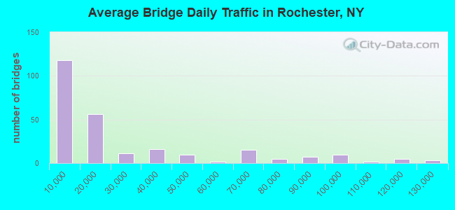
- 6,865,152Total average daily traffic
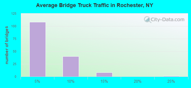
- 99,631Total average daily truck traffic
- National Bridge Inventory (NBI) Registered Bridges for Rochester
- No street view available for this location

- New bridges - historical statistics
- 11Before 1900
- 151900-1909
- 91910-1919
- 41920-1929
- 91930-1939
- 21940-1949
- 251950-1959
- 491960-1969
- 671970-1979
- 261980-1989
- 331990-1999
- 232000-2009
- 12010-2019
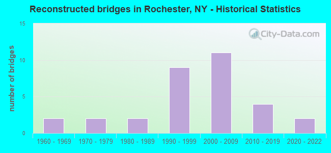
- Reconstructed bridges - Historical Statistics
- 21960-1969
- 21970-1979
- 21980-1989
- 91990-1999
- 112000-2009
- 42010-2019
- 22020-2022
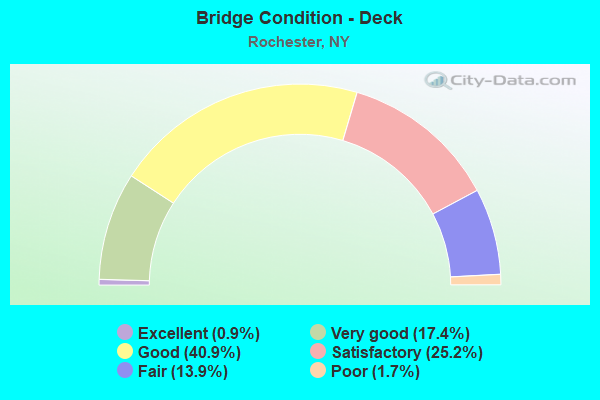
- Bridge Condition - Deck
- 0.9%Excellent
- 17.4%Very good
- 40.9%Good
- 25.2%Satisfactory
- 13.9%Fair
- 1.7%Poor

- Bridge Condition - Superstructure
- 1.7%Excellent
- 15.5%Very good
- 39.7%Good
- 28.4%Satisfactory
- 12.9%Fair
- 1.7%Poor
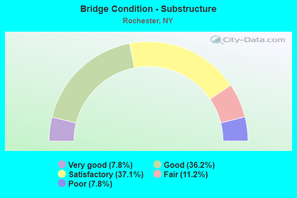
- Bridge Condition - Substructure
- 7.8%Very good
- 36.2%Good
- 37.1%Satisfactory
- 11.2%Fair
- 7.8%Poor
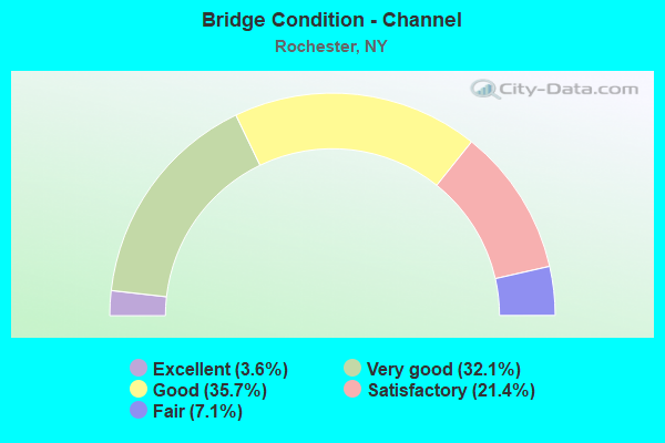
- Bridge Condition - Channel
- 3.6%Excellent
- 32.1%Very good
- 35.7%Good
- 21.4%Satisfactory
- 7.1%Fair
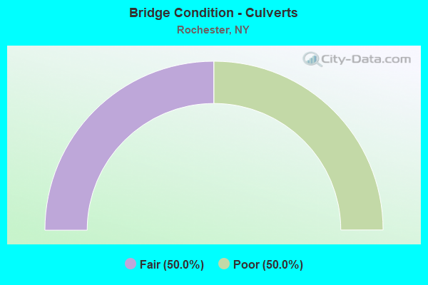
- Bridge Condition - Culverts
- 50.0%Fair
- 50.0%Poor
Find on map >> Show street view
Structure Number: 105217, Location: 0.6MI E JCT104+GENESEE R (Lat: 43.191400, Lng: -77.608675), Route carried "on" structure: City street , Year Built: 1969, Status: Open, Structure Length: 4.79m (15.72ft), Average Daily Traffic: 7,918 (year 2017), Truck Traffic: 3%, Average Future Daily Traffic: 9,796 (year 2040), Design Load: HS 20+Mod, Features Intersected: 104 104 43032029 WB, RTE, Facility Carried by Structure: SENECA AVENUE
Minimum Vertical Clearance: 30+ m (98+ ft), Kilometerpoint: 0.547, Lanes on structure: 4, Lanes under structure: 8, Owner: State Highway Agency, Approaching Roadway Width: 18.9m (62.0ft), Skew: 20 degrees, Material/Design: Steel, Design/Construction: Stringer/Multi-beam, Number Of Spans In Main Unit: 2, Length of Maximum Span: 22.8m (74.8ft), Curb or Sidewalk Widths: Left: 2.0m (6.6ft), Right: 2.0m (6.6ft), Curb-To-Curb Width: 18.9m (62.0ft), Out-to-Out Width: 23.9m (78.4ft)
Condition: Deck: Good, Superstructure: Satisfactory, Substructure: Satisfactory, Operating Rating: 60.8 metric tons, Method Used To Determine Operating Rating: Load Factor (LF), Inventory Rating: 36.3 metric tons, Method Used To Determine Inventory Rating: Load Factor (LF), Structural Evaluation: Equal to present minimum criteria, Deck Geometry: Equal to present minimum criteria, Underclear: High priority of corrective action, Approach Roadway Alignment: Equal to present minimum criteria, Length Of Structure Improvement: 4.78m (15.68ft), Designated Inspection Frequency: Every 24 months, Inspection Date: December 2021, Bridge Improvement Cost: $3,248,000, Roadway Improvement Cost: $1,902,000, Total Project Cost: $5,150,000 ( Estimate for 2021), Deck Structure Type: Concrete Cast-file-Place, Wearing Surface/Protective System: Wearing Surface: Bituminous
Find on map >> Show street view
Structure Number: 1052189, Location: 1.0MI E JCT104+GENESEE R (Lat: 43.191914, Lng: -77.599881), Route carried "on" structure: US 104, Year Built: 1969, Status: Open, Structure Length: 4.79m (15.72ft), Average Daily Traffic: 50,186 (year 2019), Truck Traffic: 3%, Average Future Daily Traffic: 52,349 (year 2040), Design Load: HS 20+Mod, Features Intersected: HUDSON AVENUE
Minimum Vertical Clearance: 30+ m (98+ ft), Kilometerpoint: 33.596, Lanes on structure: 8, Lanes under structure: 5, Base Highway Network: Yes, Owner: State Highway Agency, Approaching Roadway Width: 35.4m (116.1ft), Skew: 20 degrees, Material/Design: Steel, Design/Construction: Stringer/Multi-beam, Number Of Spans In Main Unit: 3, Length of Maximum Span: 22.5m (73.8ft), Curb-To-Curb Width: 33.3m (109.3ft), Out-to-Out Width: 35.6m (116.8ft)
Condition: Deck: Satisfactory, Superstructure: Fair, Substructure: Fair, Operating Rating: 60.8 metric tons, Method Used To Determine Operating Rating: Load Factor (LF), Inventory Rating: 36.3 metric tons, Method Used To Determine Inventory Rating: Load Factor (LF), Structural Evaluation: Somewhat better than minimum adequacy, Deck Geometry: Meets minimum limits, Underclear: High priority of corrective action, Approach Roadway Alignment: Equal to present minimum criteria, Length Of Structure Improvement: 4.78m (15.68ft), Designated Inspection Frequency: Every 24 months, Inspection Date: September 2020, Bridge Improvement Cost: $4,112,000, Roadway Improvement Cost: $2,408,000, Total Project Cost: $6,521,000 ( Estimate for 2021), Deck Structure Type: Concrete Cast-file-Place, Wearing Surface/Protective System: Wearing Surface: Bituminous, Membrane: Preformed Fabric
Find on map >> Show street view
Structure Number: 1052191, Location: 1.4MI E JCT104+GENESEE R (Lat: 43.193508, Lng: -77.592203), Route carried "on" structure: US 104, Year Built: 1969, Status: Open, Structure Length: 4.79m (15.72ft), Average Daily Traffic: 35,224 (year 2020), Truck Traffic: 3%, Average Future Daily Traffic: 36,742 (year 2040), Design Load: HS 20+Mod, Features Intersected: CARTER STREET
Minimum Vertical Clearance: 30+ m (98+ ft), Kilometerpoint: 34.240, Lanes on structure: 3, Lanes under structure: 4, Base Highway Network: Yes, Owner: State Highway Agency, Approaching Roadway Width: 11.0m (36.1ft), Skew: 1 degrees, Material/Design: Steel, Design/Construction: Stringer/Multi-beam, Number Of Spans In Main Unit: 3, Length of Maximum Span: 19.2m (63.0ft), Curb-To-Curb Width: 12.2m (40.0ft), Out-to-Out Width: 13.7m (44.9ft)
Condition: Deck: Satisfactory, Superstructure: Satisfactory, Substructure: Good, Operating Rating: 80.7 metric tons, Method Used To Determine Operating Rating: Load Factor (LF), Inventory Rating: 48.1 metric tons, Method Used To Determine Inventory Rating: Load Factor (LF), Structural Evaluation: Equal to present minimum criteria, Deck Geometry: High priority of replacement, Underclear: Superior to present desirable criteria, Approach Roadway Alignment: Equal to present minimum criteria, Length Of Structure Improvement: 4.78m (15.68ft), Designated Inspection Frequency: Every 24 months, Inspection Date: November 2021, Bridge Improvement Cost: $1,549,000, Roadway Improvement Cost: $907,000, Total Project Cost: $2,456,000 ( Estimate for 2021), Deck Structure Type: Concrete Cast-file-Place, Wearing Surface/Protective System: Wearing Surface: Bituminous, Membrane: Preformed Fabric, Deck Protection: Other Coated Reinforcing
Find on map >> Show street view
Structure Number: 1052192, Location: 1.4MI E JCT104+GENESEE R (Lat: 43.193306, Lng: -77.592194), Route carried "on" structure: US 104, Year Built: 1969, Status: Open, Structure Length: 4.48m (14.70ft), Average Daily Traffic: 35,224 (year 2020), Truck Traffic: 3%, Average Future Daily Traffic: 36,742 (year 2040), Design Load: HS 20+Mod, Features Intersected: CARTER STREET
Minimum Vertical Clearance: 30+ m (98+ ft), Kilometerpoint: 34.240, Lanes on structure: 3, Lanes under structure: 4, Base Highway Network: Yes, Owner: State Highway Agency, Approaching Roadway Width: 11.0m (36.1ft), Skew: 1 degrees, Material/Design: Steel, Design/Construction: Stringer/Multi-beam, Number Of Spans In Main Unit: 3, Length of Maximum Span: 19.2m (63.0ft), Curb-To-Curb Width: 12.2m (40.0ft), Out-to-Out Width: 13.7m (44.9ft)
Condition: Deck: Fair, Superstructure: Poor, Substructure: Satisfactory, Operating Rating: 81.6 metric tons, Method Used To Determine Operating Rating: Load Factor (LF), Inventory Rating: 49.0 metric tons, Method Used To Determine Inventory Rating: Load Factor (LF), Structural Evaluation: Meets minimum limits, Deck Geometry: High priority of replacement, Underclear: Equal to present minimum criteria, Approach Roadway Alignment: Equal to present minimum criteria, Length Of Structure Improvement: 4.48m (14.70ft), Designated Inspection Frequency: Every 24 months, Inspection Date: November 2021, Bridge Improvement Cost: $1,462,000, Roadway Improvement Cost: $856,000, Total Project Cost: $2,318,000 ( Estimate for 2021), Deck Structure Type: Concrete Cast-file-Place, Wearing Surface/Protective System: Wearing Surface: Bituminous, Membrane: Preformed Fabric, Deck Protection: Other Coated Reinforcing
Find on map >> Show street view
Structure Number: 1052221, Location: 3.0MI E JCT104+GENESEE R (Lat: 43.196039, Lng: -77.561386), Route carried "on" structure: State highway 104, Year Built: 1967, Status: Open, Structure Length: 3.63m (11.91ft), Average Daily Traffic: 22,047 (year 2020), Truck Traffic: 3%, Average Future Daily Traffic: 22,997 (year 2040), Design Load: HS 20, Features Intersected: CULVER ROAD
Minimum Vertical Clearance: 30+ m (98+ ft), Kilometerpoint: 36.798, Lanes on structure: 3, Lanes under structure: 5, Base Highway Network: Yes, Owner: State Highway Agency, Approaching Roadway Width: 11.0m (36.1ft), Material/Design: Steel, Design/Construction: Stringer/Multi-beam, Number Of Spans In Main Unit: 1, Length of Maximum Span: 35.0m (114.8ft), Curb or Sidewalk Widths: Left: 0.5m (1.6ft), Right: 0.5m (1.6ft), Curb-To-Curb Width: 12.2m (40.0ft), Out-to-Out Width: 13.7m (44.9ft)
Condition: Deck: Good, Superstructure: Very good, Substructure: Satisfactory, Operating Rating: 43.1 metric tons, Method Used To Determine Operating Rating: Load and Resistance Factor Rating (LRFR) rating reported by rating factor(RF) method using HL-93 loadings, Inventory Rating: 33.4 metric tons, Method Used To Determine Inventory Rating: Load and Resistance Factor Rating (LRFR) rating reported by rating factor(RF) method using HL-93 loadings, Structural Evaluation: Equal to present minimum criteria, Deck Geometry: High priority of replacement, Underclear: Meets minimum limits, Approach Roadway Alignment: Equal to present minimum criteria, Length Of Structure Improvement: 3.62m (11.88ft), Designated Inspection Frequency: Every 24 months, Inspection Date: April 2021, Bridge Improvement Cost: $1,351,000, Roadway Improvement Cost: $791,000, Total Project Cost: $2,142,000 ( Estimate for 2021), Deck Structure Type: Concrete Cast-file-Place, Wearing Surface/Protective System: Wearing Surface: Bituminous
Find on map >> Show street view
Structure Number: 1052222, Location: 3.0MI E JCT104+GENESEE R (Lat: 43.195828, Lng: -77.561378), Route carried "on" structure: State highway 104, Year Built: 1967, Status: Open, Structure Length: 3.63m (11.91ft), Average Daily Traffic: 22,047 (year 2020), Truck Traffic: 3%, Average Future Daily Traffic: 22,997 (year 2040), Design Load: HS 20, Features Intersected: CULVER ROAD
Minimum Vertical Clearance: 30+ m (98+ ft), Kilometerpoint: 36.798, Lanes on structure: 3, Lanes under structure: 5, Base Highway Network: Yes, Owner: State Highway Agency, Approaching Roadway Width: 15.8m (51.8ft), Material/Design: Steel, Design/Construction: Stringer/Multi-beam, Number Of Spans In Main Unit: 1, Length of Maximum Span: 35.0m (114.8ft), Curb or Sidewalk Widths: Left: 0.5m (1.6ft), Right: 0.5m (1.6ft), Curb-To-Curb Width: 12.2m (40.0ft), Out-to-Out Width: 13.7m (44.9ft)
Condition: Deck: Satisfactory, Superstructure: Very good, Substructure: Satisfactory, Operating Rating: 43.1 metric tons, Method Used To Determine Operating Rating: Load and Resistance Factor Rating (LRFR) rating reported by rating factor(RF) method using HL-93 loadings, Inventory Rating: 33.4 metric tons, Method Used To Determine Inventory Rating: Load and Resistance Factor Rating (LRFR) rating reported by rating factor(RF) method using HL-93 loadings, Structural Evaluation: Equal to present minimum criteria, Deck Geometry: High priority of replacement, Underclear: Meets minimum limits, Approach Roadway Alignment: Equal to present minimum criteria, Length Of Structure Improvement: 3.62m (11.88ft), Designated Inspection Frequency: Every 24 months, Inspection Date: April 2021, Bridge Improvement Cost: $1,386,000, Roadway Improvement Cost: $811,000, Total Project Cost: $2,197,000 ( Estimate for 2021), Deck Structure Type: Concrete Cast-file-Place, Wearing Surface/Protective System: Wearing Surface: Bituminous
Find on map >> Show street view
Structure Number: 1062349, Location: 2.7MI E JCT ROL+I490 WEST (Lat: 43.157258, Lng: -77.626364), Route carried "on" structure: Interstate 490, Year Built: 1971, Status: Open, Structure Length: 6.95m (22.80ft), Average Daily Traffic: 69,450 (year 2019), Truck Traffic: 5%, Average Future Daily Traffic: 96,584 (year 2040), Design Load: HS 20, Features Intersected: BROWN STREET
Minimum Vertical Clearance: 30+ m (98+ ft), Kilometerpoint: 32.936, Lanes on structure: 6, Lanes under structure: 2, Base Highway Network: Yes, Owner: State Highway Agency, Approaching Roadway Width: 29.3m (96.1ft), Skew: 22 degrees, Material/Design: Steel, Design/Construction: Stringer/Multi-beam, Number Of Spans In Main Unit: 3, Length of Maximum Span: 28.0m (91.9ft), Curb-To-Curb Width: 29.9m (98.1ft), Out-to-Out Width: 34.9m (114.5ft)
Condition: Deck: Good, Superstructure: Satisfactory, Substructure: Good, Operating Rating: 65.3 metric tons, Method Used To Determine Operating Rating: Load Factor (LF), Inventory Rating: 39.0 metric tons, Method Used To Determine Inventory Rating: Load Factor (LF), Structural Evaluation: Equal to present minimum criteria, Deck Geometry: Superior to present desirable criteria, Underclear: Somewhat better than minimum adequacy, Approach Roadway Alignment: Equal to present minimum criteria, Length Of Structure Improvement: 6.94m (22.77ft), Designated Inspection Frequency: Every 24 months, Inspection Date: October 2021, Bridge Improvement Cost: $6,446,000, Roadway Improvement Cost: $3,775,000, Total Project Cost: $10,221,000 ( Estimate for 2021), Deck Structure Type: Concrete Cast-file-Place, Wearing Surface/Protective System: Wearing Surface: Latex Concrete
Find on map >> Show street view
Structure Number: 1062359, Location: JCT I490EAST + RTE 31 (Lat: 43.157631, Lng: -77.624686), Route carried "on" structure: Interstate 490, Year Built: 1971, Status: Open, Structure Length: 4.08m (13.39ft), Average Daily Traffic: 64,396 (year 2019), Truck Traffic: 5%, Average Future Daily Traffic: 89,555 (year 2040), Design Load: HS 20+Mod, Features Intersected: RTE 31X BROAD ST, Roches
Minimum Vertical Clearance: 30+ m (98+ ft), Kilometerpoint: 33.065, Lanes on structure: 6, Lanes under structure: 4, Base Highway Network: Yes, Owner: State Highway Agency, Approaching Roadway Width: 36.0m (118.1ft), Skew: 22 degrees, Material/Design: Steel, Design/Construction: Stringer/Multi-beam, Number Of Spans In Main Unit: 1, Length of Maximum Span: 39.3m (128.9ft), Curb or Sidewalk Widths: Left: 0.5m (1.6ft), Right: 0.0m, Curb-To-Curb Width: 31.4m (103.0ft), Out-to-Out Width: 36.5m (119.8ft)
Condition: Deck: Good, Superstructure: Good, Substructure: Satisfactory, Operating Rating: 97.1 metric tons, Method Used To Determine Operating Rating: Load Factor (LF), Inventory Rating: 58.1 metric tons, Method Used To Determine Inventory Rating: Load Factor (LF), Structural Evaluation: Equal to present minimum criteria, Deck Geometry: Superior to present desirable criteria, Underclear: Somewhat better than minimum adequacy, Approach Roadway Alignment: Equal to present desirable criteria, Length Of Structure Improvement: 4.08m (13.39ft), Designated Inspection Frequency: Every 24 months, Inspection Date: July 2021, Bridge Improvement Cost: $5,592,000, Roadway Improvement Cost: $3,275,000, Total Project Cost: $8,867,000 ( Estimate for 2021), Deck Structure Type: Concrete Cast-file-Place, Wearing Surface/Protective System: Wearing Surface: Latex Concrete
Find on map >> Show street view
Structure Number: 1062361, Location: .3 MI W JCT I490 & W MAIN (Lat: 43.157342, Lng: -77.622558), Route carried "on" structure: Interstate 490, Year Built: 1969, Status: Open, Structure Length: 2.93m (9.61ft), Average Daily Traffic: 49,007 (year 2014), Truck Traffic: 5%, Design Load: HS 20+Mod, Features Intersected: PLATT STREET
Minimum Vertical Clearance: 30+ m (98+ ft), Kilometerpoint: 33.242, Lanes on structure: 4, Lanes under structure: 2, Base Highway Network: Yes, Owner: State Highway Agency, Approaching Roadway Width: 15.2m (49.9ft), Skew: 1 degrees, Material/Design: Steel, Design/Construction: Stringer/Multi-beam, Number Of Spans In Main Unit: 1, Length of Maximum Span: 27.7m (90.9ft), Curb-To-Curb Width: 15.2m (49.9ft), Out-to-Out Width: 16.9m (55.4ft)
Condition: Deck: Good, Superstructure: Good, Substructure: Good, Operating Rating: 88.9 metric tons, Method Used To Determine Operating Rating: Load Factor (LF), Inventory Rating: 53.5 metric tons, Method Used To Determine Inventory Rating: Load Factor (LF), Structural Evaluation: Better than present minimum criteria, Deck Geometry: High priority of replacement, Underclear: Somewhat better than minimum adequacy, Approach Roadway Alignment: Equal to present desirable criteria, Length Of Structure Improvement: 2.92m (9.58ft), Designated Inspection Frequency: Every 24 months, Inspection Date: November 2021, Bridge Improvement Cost: $1,557,000, Roadway Improvement Cost: $912,000, Total Project Cost: $2,468,000 ( Estimate for 2021), Deck Structure Type: Concrete Cast-file-Place, Wearing Surface/Protective System: Wearing Surface: Latex Concrete
Find on map >> Show street view
Structure Number: 1062362, Location: .3 MI W JCT I490 & W MAIN (Lat: 43.157139, Lng: -77.622733), Route carried "on" structure: Interstate 490, Year Built: 1969, Status: Open, Structure Length: 2.93m (9.61ft), Average Daily Traffic: 32,198 (year 2019), Truck Traffic: 5%, Average Future Daily Traffic: 44,778 (year 2040), Design Load: HS 20+Mod, Features Intersected: PLATT STREET
Minimum Vertical Clearance: 30+ m (98+ ft), Kilometerpoint: 33.242, Lanes on structure: 4, Lanes under structure: 2, Base Highway Network: Yes, Owner: State Highway Agency, Approaching Roadway Width: 19.2m (63.0ft), Material/Design: Steel, Design/Construction: Stringer/Multi-beam, Number Of Spans In Main Unit: 1, Length of Maximum Span: 27.7m (90.9ft), Curb-To-Curb Width: 19.4m (63.6ft), Out-to-Out Width: 20.7m (67.9ft)
Condition: Deck: Good, Superstructure: Good, Substructure: Good, Operating Rating: 91.6 metric tons, Method Used To Determine Operating Rating: Load Factor (LF), Inventory Rating: 54.4 metric tons, Method Used To Determine Inventory Rating: Load Factor (LF), Structural Evaluation: Better than present minimum criteria, Deck Geometry: Somewhat better than minimum adequacy, Underclear: Meets minimum limits, Approach Roadway Alignment: Equal to present desirable criteria, Length Of Structure Improvement: 2.92m (9.58ft), Designated Inspection Frequency: Every 24 months, Inspection Date: November 2021, Bridge Improvement Cost: $1,904,000, Roadway Improvement Cost: $1,115,000, Total Project Cost: $3,019,000 ( Estimate for 2021), Deck Structure Type: Concrete Cast-file-Place, Wearing Surface/Protective System: Wearing Surface: Latex Concrete
Find on map >> Show street view
Structure Number: 1062389, Location: 1.3MI E JCT RTS I490+ROL (Lat: 43.156992, Lng: -77.654128), Route carried "on" structure: Interstate 490, Year Built: 1971, Year Reconstructed: 2010, Status: Open, Structure Length: 3.17m (10.40ft), Average Daily Traffic: 66,335 (year 2019), Truck Traffic: 4%, Average Future Daily Traffic: 92,252 (year 2040), Features Intersected: GLIDE STREET
Minimum Vertical Clearance: 30+ m (98+ ft), Kilometerpoint: 30.668, Lanes on structure: 8, Lanes under structure: 2, Base Highway Network: Yes, Owner: State Highway Agency, Approaching Roadway Width: 37.5m (123.0ft), Skew: 20 degrees, Material/Design: Steel, Design/Construction: Stringer/Multi-beam, Number Of Spans In Main Unit: 1, Length of Maximum Span: 30.5m (100.1ft), Curb-To-Curb Width: 37.5m (123.0ft), Out-to-Out Width: 40.5m (132.9ft)
Condition: Deck: Good, Superstructure: Satisfactory, Substructure: Good, Operating Rating: 31.4 metric tons, Method Used To Determine Operating Rating: Load and Resistance Factor Rating (LRFR) rating reported by rating factor(RF) method using HL-93 loadings, Inventory Rating: 24.3 metric tons, Method Used To Determine Inventory Rating: Load and Resistance Factor Rating (LRFR) rating reported by rating factor(RF) method using HL-93 loadings, Structural Evaluation: Equal to present minimum criteria, Deck Geometry: Superior to present desirable criteria, Underclear: Meets minimum limits, Approach Roadway Alignment: Equal to present desirable criteria, Length Of Structure Improvement: 3.16m (10.37ft), Designated Inspection Frequency: Every 24 months, Inspection Date: May 2021, Bridge Improvement Cost: $4,035,000, Roadway Improvement Cost: $2,363,000, Total Project Cost: $6,398,000 ( Estimate for 2021), Deck Structure Type: Concrete Cast-file-Place, Wearing Surface/Protective System: Wearing Surface: Integral Concrete, Deck Protection: Epoxy Coated Reinforcing
Find on map >> Show street view
Structure Number: 1062399, Location: 1.6 MI E JCT I490 & R.O.L (Lat: 43.157206, Lng: -77.649228), Route carried "on" structure: Interstate 490, Year Built: 1971, Status: Open, Structure Length: 7.56m (24.80ft), Average Daily Traffic: 66,335 (year 2019), Truck Traffic: 4%, Average Future Daily Traffic: 92,252 (year 2040), Design Load: HS 20, Features Intersected: CSX TRANS/AMTRAK
Minimum Vertical Clearance: 30+ m (98+ ft), Kilometerpoint: 31.022, Lanes on structure: 8, Base Highway Network: Yes, Owner: State Highway Agency, Approaching Roadway Width: 31.1m (102.0ft), Skew: 21 degrees, Material/Design: Steel, Design/Construction: Stringer/Multi-beam, Number Of Spans In Main Unit: 3, Length of Maximum Span: 28.6m (93.8ft), Curb-To-Curb Width: 32.5m (106.6ft), Out-to-Out Width: 35.2m (115.5ft)
Condition: Deck: Satisfactory, Superstructure: Fair, Substructure: Poor, Operating Rating: 64.4 metric tons, Method Used To Determine Operating Rating: Load Factor (LF), Inventory Rating: 38.1 metric tons, Method Used To Determine Inventory Rating: Load Factor (LF), Structural Evaluation: Meets minimum limits, Deck Geometry: Meets minimum limits, Underclear: Better than present minimum criteria, Approach Roadway Alignment: Better than present minimum criteria, Length Of Structure Improvement: 7.55m (24.77ft), Designated Inspection Frequency: Every 24 months, Inspection Date: December 2021, Bridge Improvement Cost: $8,719,000, Roadway Improvement Cost: $5,106,000, Total Project Cost: $13,825,000 ( Estimate for 2021), Deck Structure Type: Concrete Cast-file-Place, Wearing Surface/Protective System: Wearing Surface: Bituminous
Find on map >> Show street view
Structure Number: 10624, Location: 1.9MI E JCT RTS I490+ROL (Lat: 43.157047, Lng: -77.643964), Route carried "on" structure: City street , Year Built: 1971, Year Reconstructed: 2003, Status: Open, Structure Length: 4.11m (13.48ft), Average Daily Traffic: 6,824 (year 2020), Truck Traffic: 2%, Average Future Daily Traffic: 8,443 (year 2040), Design Load: HS 20, Features Intersected: 490I490I43022015 WB, RTE, Facility Carried by Structure: AMES STREET
Minimum Vertical Clearance: 30+ m (98+ ft), Kilometerpoint: 0.788, Lanes on structure: 3, Lanes under structure: 6, Owner: State Highway Agency, Approaching Roadway Width: 11.0m (36.1ft), Material/Design: Steel continuous, Design/Construction: Stringer/Multi-beam, Number Of Spans In Main Unit: 2, Length of Maximum Span: 21.0m (68.9ft), Curb or Sidewalk Widths: Left: 2.5m (8.2ft), Right: 2.5m (8.2ft), Curb-To-Curb Width: 11.0m (36.1ft), Out-to-Out Width: 16.6m (54.5ft)
Condition: Deck: Good, Superstructure: Good, Substructure: Good, Operating Rating: 75.3 metric tons, Method Used To Determine Operating Rating: Load Factor (LF), Inventory Rating: 44.5 metric tons, Method Used To Determine Inventory Rating: Load Factor (LF), Structural Evaluation: Better than present minimum criteria, Deck Geometry: High priority of replacement, Underclear: High priority of corrective action, Approach Roadway Alignment: Equal to present minimum criteria, Length Of Structure Improvement: 4.11m (13.48ft), Designated Inspection Frequency: Every 24 months, Inspection Date: November 2021, Bridge Improvement Cost: $2,047,000, Roadway Improvement Cost: $1,199,000, Total Project Cost: $3,246,000 ( Estimate for 2021), Deck Structure Type: Concrete Cast-file-Place, Wearing Surface/Protective System: Wearing Surface: Integral Concrete, Deck Protection: Epoxy Coated Reinforcing
Find on map >> Show street view
Structure Number: 106242, Location: 2.2 MI E JCT I490 & ROL (Lat: 43.156692, Lng: -77.638881), Route carried "on" structure: City street , Year Built: 1971, Year Reconstructed: 2004, Status: Open, Structure Length: 5.00m (16.40ft), Average Daily Traffic: 5,615 (year 2017), Truck Traffic: 5%, Average Future Daily Traffic: 6,947 (year 2040), Design Load: HS 20, Features Intersected: 490I490I43022017, RTE I4, Facility Carried by Structure: CHILD STREET
Minimum Vertical Clearance: 30+ m (98+ ft), Kilometerpoint: 0.531, Lanes on structure: 3, Lanes under structure: 7, Owner: State Highway Agency, Approaching Roadway Width: 11.0m (36.1ft), Skew: 20 degrees, Material/Design: Steel continuous, Design/Construction: Stringer/Multi-beam, Number Of Spans In Main Unit: 2, Length of Maximum Span: 28.6m (93.8ft), Curb or Sidewalk Widths: Left: 2.5m (8.2ft), Right: 2.5m (8.2ft), Curb-To-Curb Width: 11.0m (36.1ft), Out-to-Out Width: 16.6m (54.5ft)
Condition: Deck: Good, Superstructure: Satisfactory, Substructure: Good, Operating Rating: 68.9 metric tons, Method Used To Determine Operating Rating: Load Factor (LF), Inventory Rating: 40.8 metric tons, Method Used To Determine Inventory Rating: Load Factor (LF), Structural Evaluation: Equal to present minimum criteria, Deck Geometry: High priority of replacement, Underclear: High priority of corrective action, Approach Roadway Alignment: Equal to present desirable criteria, Length Of Structure Improvement: 4.99m (16.37ft), Designated Inspection Frequency: Every 24 months, Inspection Date: August 2020, Bridge Improvement Cost: $1,954,000, Roadway Improvement Cost: $1,144,000, Total Project Cost: $3,098,000 ( Estimate for 2021), Deck Structure Type: Concrete Cast-file-Place, Wearing Surface/Protective System: Wearing Surface: Integral Concrete, Deck Protection: Epoxy Coated Reinforcing
Find on map >> Show street view
Structure Number: 106243, Location: 2.5MI E JCT RTS I490+ROL (Lat: 43.156508, Lng: -77.632314), Route carried "on" structure: City street , Year Built: 1971, Year Reconstructed: 2003, Status: Open, Structure Length: 4.94m (16.21ft), Average Daily Traffic: 2,297 (year 2016), Truck Traffic: 5%, Average Future Daily Traffic: 3,216 (year 2036), Design Load: HS 20, Features Intersected: 490I490I43022021 WB, RTE, Facility Carried by Structure: SAXTON STREET
Minimum Vertical Clearance: 30+ m (98+ ft), Kilometerpoint: 0.354, Lanes on structure: 2, Lanes under structure: 8, Owner: State Highway Agency, Approaching Roadway Width: 9.1m (29.9ft), Material/Design: Steel continuous, Design/Construction: Stringer/Multi-beam, Number Of Spans In Main Unit: 2, Length of Maximum Span: 24.0m (78.7ft), Curb or Sidewalk Widths: Left: 2.1m (6.9ft), Right: 2.1m (6.9ft), Curb-To-Curb Width: 9.1m (29.9ft), Out-to-Out Width: 14.2m (46.6ft)
Condition: Deck: Very good, Superstructure: Good, Substructure: Good, Operating Rating: 71.7 metric tons, Method Used To Determine Operating Rating: Load Factor (LF), Inventory Rating: 42.6 metric tons, Method Used To Determine Inventory Rating: Load Factor (LF), Structural Evaluation: Better than present minimum criteria, Deck Geometry: Meets minimum limits, Underclear: High priority of corrective action, Approach Roadway Alignment: Equal to present desirable criteria, Length Of Structure Improvement: 4.93m (16.17ft), Designated Inspection Frequency: Every 24 months, Inspection Date: April 2021, Bridge Improvement Cost: $1,722,000, Roadway Improvement Cost: $1,008,000, Total Project Cost: $2,730,000 ( Estimate for 2021), Deck Structure Type: Concrete Cast-file-Place, Wearing Surface/Protective System: Wearing Surface: Integral Concrete, Deck Protection: Epoxy Coated Reinforcing
Find on map >> Show street view
Structure Number: 106244, Location: 2.7MI E JCT RTS I490+ROL (Lat: 43.156717, Lng: -77.629056), Route carried "on" structure: City street , Year Built: 1971, Status: Open, Structure Length: 6.16m (20.21ft), Average Daily Traffic: 2,186 (year 2020), Truck Traffic: 1%, Average Future Daily Traffic: 2,704 (year 2040), Design Load: HS 20, Features Intersected: 490I490I43022022 WB, RTE, Facility Carried by Structure: GRAPE STREET
Minimum Vertical Clearance: 30+ m (98+ ft), Kilometerpoint: 0.016, Lanes on structure: 2, Lanes under structure: 8, Owner: State Highway Agency, Approaching Roadway Width: 9.1m (29.9ft), Skew: 1 degrees, Material/Design: Steel continuous, Design/Construction: Stringer/Multi-beam, Number Of Spans In Main Unit: 2, Length of Maximum Span: 31.3m (102.7ft), Curb or Sidewalk Widths: Left: 2.1m (6.9ft), Right: 2.1m (6.9ft), Curb-To-Curb Width: 9.1m (29.9ft), Out-to-Out Width: 14.2m (46.6ft)
Condition: Deck: Good, Superstructure: Good, Substructure: Satisfactory, Operating Rating: 42.8 metric tons, Method Used To Determine Operating Rating: Load and Resistance Factor Rating (LRFR) rating reported by rating factor(RF) method using HL-93 loadings, Inventory Rating: 33.0 metric tons, Method Used To Determine Inventory Rating: Load and Resistance Factor Rating (LRFR) rating reported by rating factor(RF) method using HL-93 loadings, Structural Evaluation: Equal to present minimum criteria, Deck Geometry: Meets minimum limits, Underclear: High priority of corrective action, Approach Roadway Alignment: Equal to present minimum criteria, Length Of Structure Improvement: 6.15m (20.18ft), Designated Inspection Frequency: Every 24 months, Inspection Date: October 2021, Bridge Improvement Cost: $2,391,000, Roadway Improvement Cost: $1,400,000, Total Project Cost: $3,791,000 ( Estimate for 2021), Deck Structure Type: Concrete Cast-file-Place, Wearing Surface/Protective System: Wearing Surface: Bituminous
Find on map >> Show street view
Structure Number: 106251, Location: 1.2MI S JCT ROL + 104 (Lat: 43.191281, Lng: -77.683086), Route carried "on" structure: County highway , Year Built: 1971, Year Reconstructed: 1992, Status: Open, Structure Length: 5.88m (19.29ft), Average Daily Traffic: 18,366 (year 2018), Truck Traffic: 2%, Average Future Daily Traffic: 22,311 (year 2040), Design Load: HS 20, Features Intersected: 390 390 43011023, RTE 39, Facility Carried by Structure: RIDGEWAY AVENUE
Minimum Vertical Clearance: 30+ m (98+ ft), Kilometerpoint: 4.216, Lanes on structure: 4, Lanes under structure: 7, Owner: State Highway Agency, Approaching Roadway Width: 17.1m (56.1ft), Skew: 2 degrees, Material/Design: Steel, Design/Construction: Stringer/Multi-beam, Number Of Spans In Main Unit: 2, Length of Maximum Span: 30.4m (99.7ft), Curb or Sidewalk Widths: Left: 0.0m, Right: 1.5m (4.9ft), Curb-To-Curb Width: 17.1m (56.1ft), Out-to-Out Width: 19.3m (63.3ft)
Condition: Deck: Fair, Superstructure: Good, Substructure: Fair, Operating Rating: 81.6 metric tons, Method Used To Determine Operating Rating: Load Factor (LF), Inventory Rating: 49.0 metric tons, Method Used To Determine Inventory Rating: Load Factor (LF), Structural Evaluation: Somewhat better than minimum adequacy, Deck Geometry: Somewhat better than minimum adequacy, Underclear: High priority of corrective action, Approach Roadway Alignment: Equal to present desirable criteria, Length Of Structure Improvement: 5.88m (19.29ft), Designated Inspection Frequency: Every 24 months, Inspection Date: November 2020, Bridge Improvement Cost: $3,675,000, Roadway Improvement Cost: $2,152,000, Total Project Cost: $5,828,000 ( Estimate for 2021), Deck Structure Type: Concrete Cast-file-Place, Wearing Surface/Protective System: Wearing Surface: Bituminous, Deck Protection: Other Coated Reinforcing
Find on map >> Show street view
Structure Number: 106386, Location: 0.3MI E JCT RTE104+GEN R (Lat: 43.191283, Lng: -77.615297), Route carried "on" structure: City street , Year Built: 1968, Status: Open, Structure Length: 4.85m (15.91ft), Average Daily Traffic: 2,113 (year 2018), Truck Traffic: 4%, Average Future Daily Traffic: 2,958 (year 2038), Design Load: HS 20, Features Intersected: 104 104 43032026 WB, RTE, Facility Carried by Structure: HOLLENBECK STREET
Minimum Vertical Clearance: 30+ m (98+ ft), Kilometerpoint: 1.207, Lanes on structure: 2, Lanes under structure: 8, Owner: State Highway Agency, Approaching Roadway Width: 7.9m (25.9ft), Skew: 1 degrees, Material/Design: Steel, Design/Construction: Stringer/Multi-beam, Number Of Spans In Main Unit: 2, Length of Maximum Span: 24.6m (80.7ft), Curb or Sidewalk Widths: Left: 1.9m (6.2ft), Right: 1.9m (6.2ft), Curb-To-Curb Width: 7.9m (25.9ft), Out-to-Out Width: 12.8m (42.0ft)
Condition: Deck: Satisfactory, Superstructure: Satisfactory, Substructure: Poor, Operating Rating: 78.9 metric tons, Method Used To Determine Operating Rating: Load Factor (LF), Inventory Rating: 47.2 metric tons, Method Used To Determine Inventory Rating: Load Factor (LF), Structural Evaluation: Meets minimum limits, Deck Geometry: High priority of corrective action, Underclear: High priority of corrective action, Approach Roadway Alignment: Equal to present desirable criteria, Length Of Structure Improvement: 4.84m (15.88ft), Designated Inspection Frequency: Every 24 months, Inspection Date: November 2021, Bridge Improvement Cost: $1,966,000, Roadway Improvement Cost: $1,152,000, Total Project Cost: $3,118,000 ( Estimate for 2021), Deck Structure Type: Concrete Cast-file-Place, Wearing Surface/Protective System: Wearing Surface: Latex Concrete, Deck Protection: Other Coated Reinforcing
Find on map >> Show street view
Structure Number: 106387, Location: SOUTH AVE TO EB I490 RAMP (Lat: 43.149386, Lng: -77.606417), Route carried "on" structure: Alternate US 15, Year Built: 1971, Year Reconstructed: 2001, Status: Open, Structure Length: 2.93m (9.61ft), Average Daily Traffic: 4,658 (year 2020), Truck Traffic: 5%, Average Future Daily Traffic: 4,679 (year 2040), Design Load: HS 20, Features Intersected: RTE I490
Minimum Vertical Clearance: 30+ m (98+ ft), Kilometerpoint: 0.821, Lanes on structure: 4, Lanes under structure: 1, Owner: State Highway Agency, Approaching Roadway Width: 14.6m (47.9ft), Skew: 35 degrees, Material/Design: Steel, Design/Construction: Stringer/Multi-beam, Number Of Spans In Main Unit: 1, Length of Maximum Span: 26.8m (87.9ft), Curb or Sidewalk Widths: Left: 3.7m (12.1ft), Right: 3.7m (12.1ft), Curb-To-Curb Width: 15.8m (51.8ft), Out-to-Out Width: 24.5m (80.4ft)
Condition: Deck: Very good, Superstructure: Good, Substructure: Fair, Operating Rating: 50.9 metric tons, Method Used To Determine Operating Rating: Load and Resistance Factor Rating (LRFR) rating reported by rating factor(RF) method using HL-93 loadings, Inventory Rating: 39.2 metric tons, Method Used To Determine Inventory Rating: Load and Resistance Factor Rating (LRFR) rating reported by rating factor(RF) method using HL-93 loadings, Structural Evaluation: Somewhat better than minimum adequacy, Deck Geometry: Meets minimum limits, Underclear: High priority of corrective action, Approach Roadway Alignment: Equal to present minimum criteria, Length Of Structure Improvement: 2.92m (9.58ft), Designated Inspection Frequency: Every 24 months, Inspection Date: April 2021, Bridge Improvement Cost: $3,792,000, Roadway Improvement Cost: $2,220,000, Total Project Cost: $6,012,000 ( Estimate for 2021), Deck Structure Type: Concrete Cast-file-Place, Wearing Surface/Protective System: Wearing Surface: Other
Find on map >> Show street view
Structure Number: 1064009, Location: JCT INNER LOOP+PLYMOUTH (Lat: 43.157525, Lng: -77.617608), Route carried "on" structure: State highway 940T, Year Built: 1971, Status: Open, Structure Length: 2.96m (9.71ft), Average Daily Traffic: 43,203 (year 2020), Truck Traffic: 4%, Average Future Daily Traffic: 45,065 (year 2040), Design Load: HS 20+Mod, Features Intersected: PLYMOUTH AVENUE
Minimum Vertical Clearance: 30+ m (98+ ft), Kilometerpoint: 0.644, Lanes on structure: 4, Lanes under structure: 4, Base Highway Network: Yes, Owner: State Highway Agency, Approaching Roadway Width: 17.7m (58.1ft), Skew: 20 degrees, Material/Design: Steel, Design/Construction: Stringer/Multi-beam, Number Of Spans In Main Unit: 1, Length of Maximum Span: 28.3m (92.8ft), Curb-To-Curb Width: 17.7m (58.1ft), Out-to-Out Width: 19.4m (63.6ft)
Condition: Deck: Very good, Superstructure: Good, Substructure: Satisfactory, Operating Rating: 89.8 metric tons, Method Used To Determine Operating Rating: Load Factor (LF), Inventory Rating: 54.4 metric tons, Method Used To Determine Inventory Rating: Load Factor (LF), Structural Evaluation: Equal to present minimum criteria, Deck Geometry: Meets minimum limits, Underclear: Somewhat better than minimum adequacy, Approach Roadway Alignment: Equal to present minimum criteria, Length Of Structure Improvement: 2.95m (9.68ft), Designated Inspection Frequency: Every 24 months, Inspection Date: June 2020, Bridge Improvement Cost: $2,574,000, Roadway Improvement Cost: $1,507,000, Total Project Cost: $4,081,000 ( Estimate for 2021), Deck Structure Type: Concrete Cast-file-Place, Wearing Surface/Protective System: Wearing Surface: Integral Concrete, Deck Protection: Epoxy Coated Reinforcing
Find on map >> Show street view
Structure Number: 10707, Location: .4 MI.E JCT RTS 20 I88 (Lat: 42.762528, Lng: -74.114492), Route carried "on" structure: State highway 915, Year Built: 1981, Year Reconstructed: 2011, Status: Open, Structure Length: 9.20m (30.18ft), Average Daily Traffic: 2,383 (year 2017), Truck Traffic: 10%, Average Future Daily Traffic: 2,485 (year 2040), Design Load: HS 20, Features Intersected: 88I 88I16081088-WB, RTE
Minimum Vertical Clearance: 30+ m (98+ ft), Kilometerpoint: 0.193, Lanes on structure: 4, Lanes under structure: 5, Owner: State Highway Agency, Approaching Roadway Width: 22.9m (75.1ft), Skew: 21 degrees, Material/Design: Steel continuous, Design/Construction: Stringer/Multi-beam, Number Of Spans In Main Unit: 2, Length of Maximum Span: 45.4m (149.0ft), Curb-To-Curb Width: 22.9m (75.1ft), Out-to-Out Width: 24.1m (79.1ft)
Condition: Deck: Good, Superstructure: Satisfactory, Substructure: Good, Operating Rating: 53.1 metric tons, Method Used To Determine Operating Rating: Load and Resistance Factor Rating (LRFR) rating reported by rating factor(RF) method using HL-93 loadings, Inventory Rating: 40.2 metric tons, Method Used To Determine Inventory Rating: Load and Resistance Factor Rating (LRFR) rating reported by rating factor(RF) method using HL-93 loadings, Structural Evaluation: Equal to present minimum criteria, Deck Geometry: Superior to present desirable criteria, Underclear: High priority of corrective action, Approach Roadway Alignment: Equal to present desirable criteria, Length Of Structure Improvement: 9.20m (30.18ft), Designated Inspection Frequency: Every 24 months, Inspection Date: April 2021, Bridge Improvement Cost: $5,036,000, Roadway Improvement Cost: $2,949,000, Total Project Cost: $7,985,000 ( Estimate for 2021), Deck Structure Type: Concrete Cast-file-Place, Wearing Surface/Protective System: Wearing Surface: Integral Concrete, Deck Protection: Epoxy Coated Reinforcing
Find on map >> Show street view
Structure Number: 10709, Location: JCT RTS I-390 & 15A (Lat: 43.107819, Lng: -77.615931), Route carried "on" structure: Alternate State highway 15A, Year Built: 1981, Year Reconstructed: 2016, Status: Open, Structure Length: 5.82m (19.09ft), Average Daily Traffic: 24,732 (year 2019), Truck Traffic: 3%, Average Future Daily Traffic: 30,044 (year 2040), Design Load: HS 20, Features Intersected: 390I390I43031142, RTE I3
Minimum Vertical Clearance: 30+ m (98+ ft), Kilometerpoint: 20.402, Lanes on structure: 6, Lanes under structure: 7, Base Highway Network: Yes, Owner: State Highway Agency, Approaching Roadway Width: 21.9m (71.9ft), Skew: 1 degrees, Material/Design: Steel, Design/Construction: Stringer/Multi-beam, Number Of Spans In Main Unit: 1, Length of Maximum Span: 56.9m (186.7ft), Curb or Sidewalk Widths: Left: 1.4m (4.6ft), Right: 2.4m (7.9ft), Curb-To-Curb Width: 21.9m (71.9ft), Out-to-Out Width: 26.4m (86.6ft)
Condition: Deck: Good, Superstructure: Good, Substructure: Good, Inventory Rating: 63.5 metric tons, Method Used To Determine Inventory Rating: Load Factor (LF), Structural Evaluation: Better than present minimum criteria, Deck Geometry: High priority of corrective action, Underclear: High priority of corrective action, Approach Roadway Alignment: Equal to present desirable criteria, Length Of Structure Improvement: 5.82m (19.09ft), Designated Inspection Frequency: Every 24 months, Inspection Date: December 2021, Bridge Improvement Cost: $4,861,000, Roadway Improvement Cost: $2,847,000, Total Project Cost: $7,708,000 ( Estimate for 2021), Deck Structure Type: Concrete Cast-file-Place, Wearing Surface/Protective System: Wearing Surface: Integral Concrete, Deck Protection: Epoxy Coated Reinforcing
Find on map >> Show street view
Structure Number: 10718, Location: 1.8MI E GENESEO LIV CO (Lat: 42.794333, Lng: -77.761894), Route carried "on" structure: Other road , Year Built: 1982, Status: Open, Structure Length: 8.72m (28.61ft), Average Daily Traffic: 827 (year 2017), Truck Traffic: 2%, Average Future Daily Traffic: 1,158 (year 2037), Design Load: HS 20, Features Intersected: 390I390I42021240 NB, RTE, Facility Carried by Structure: RESERVOIR ROAD
Minimum Vertical Clearance: 30+ m (98+ ft), Kilometerpoint: 2.430, Lanes on structure: 2, Lanes under structure: 4, Owner: State Highway Agency, Approaching Roadway Width: 10.7m (35.1ft), Skew: 2 degrees, Material/Design: Steel continuous, Design/Construction: Stringer/Multi-beam, Number Of Spans In Main Unit: 2, Length of Maximum Span: 43.2m (141.7ft), Curb-To-Curb Width: 10.7m (35.1ft), Out-to-Out Width: 11.6m (38.1ft)
Condition: Deck: Good, Superstructure: Good, Substructure: Good, Operating Rating: 86.2 metric tons, Method Used To Determine Operating Rating: Load Factor (LF), Inventory Rating: 51.7 metric tons, Method Used To Determine Inventory Rating: Load Factor (LF), Structural Evaluation: Better than present minimum criteria, Deck Geometry: Equal to present minimum criteria, Underclear: Meets minimum limits, Approach Roadway Alignment: Equal to present desirable criteria, Length Of Structure Improvement: 8.71m (28.58ft), Designated Inspection Frequency: Every 24 months, Inspection Date: August 2020, Bridge Improvement Cost: $2,445,000, Roadway Improvement Cost: $1,432,000, Total Project Cost: $3,877,000 ( Estimate for 2021), Deck Structure Type: Concrete Cast-file-Place, Wearing Surface/Protective System: Wearing Surface: Bituminous, Deck Protection: Epoxy Coated Reinforcing
Find on map >> Show street view
Structure Number: 1072409, Location: 0.2 MI SW JCT RTS390&LOSP (Lat: 43.267025, Lng: -77.665533), Route carried "on" structure: State highway 390, Year Built: 1983, Status: Open, Structure Length: 3.51m (11.52ft), Average Daily Traffic: 18,662 (year 2020), Truck Traffic: 1%, Average Future Daily Traffic: 19,466 (year 2040), Design Load: HS 20, Features Intersected: JANES ROAD
Minimum Vertical Clearance: 30+ m (98+ ft), Kilometerpoint: 12.550, Lanes on structure: 4, Lanes under structure: 2, Base Highway Network: Yes, Owner: State Highway Agency, Approaching Roadway Width: 24.4m (80.1ft), Skew: 31 degrees, Material/Design: Steel, Design/Construction: Stringer/Multi-beam, Number Of Spans In Main Unit: 1, Length of Maximum Span: 33.8m (110.9ft), Curb-To-Curb Width: 26.6m (87.3ft), Out-to-Out Width: 27.6m (90.6ft)
Condition: Deck: Fair, Superstructure: Very good, Substructure: Satisfactory, Operating Rating: 82.6 metric tons, Method Used To Determine Operating Rating: Load Factor (LF), Inventory Rating: 49.0 metric tons, Method Used To Determine Inventory Rating: Load Factor (LF), Structural Evaluation: Equal to present minimum criteria, Deck Geometry: Superior to present desirable criteria, Underclear: Equal to present minimum criteria, Approach Roadway Alignment: Equal to present desirable criteria, Length Of Structure Improvement: 3.50m (11.48ft), Designated Inspection Frequency: Every 24 months, Inspection Date: August 2021, Bridge Improvement Cost: $2,705,000, Roadway Improvement Cost: $1,584,000, Total Project Cost: $4,289,000 ( Estimate for 2021), Deck Structure Type: Concrete Cast-file-Place, Wearing Surface/Protective System: Wearing Surface: Integral Concrete, Deck Protection: Epoxy Coated Reinforcing
Find on map >> Show street view
Structure Number: 107241, Location: 0.1MI E INTER RT 390&LOSP (Lat: 43.267836, Lng: -77.661414), Route carried "on" structure: Other road , Year Built: 1983, Status: Open, Structure Length: 4.60m (15.09ft), Average Daily Traffic: 1,879 (year 2017), Truck Traffic: 4%, Average Future Daily Traffic: 2,324 (year 2040), Design Load: HS 20, Features Intersected: LOSP Multi-Use Trail, 94, Facility Carried by Structure: ISLAND COTTAGE RD
Minimum Vertical Clearance: 30+ m (98+ ft), Kilometerpoint: 1.754, Lanes on structure: 2, Lanes under structure: 5, Owner: State Highway Agency, Approaching Roadway Width: 13.4m (44.0ft), Material/Design: Steel, Design/Construction: Stringer/Multi-beam, Number Of Spans In Main Unit: 1, Length of Maximum Span: 44.5m (146.0ft), Curb-To-Curb Width: 13.4m (44.0ft), Out-to-Out Width: 14.3m (46.9ft)
Condition: Deck: Good, Superstructure: Good, Substructure: Good, Operating Rating: 92.5 metric tons, Method Used To Determine Operating Rating: Load Factor (LF), Inventory Rating: 55.3 metric tons, Method Used To Determine Inventory Rating: Load Factor (LF), Structural Evaluation: Better than present minimum criteria, Deck Geometry: Equal to present desirable criteria, Underclear: Meets minimum limits, Approach Roadway Alignment: Equal to present desirable criteria, Length Of Structure Improvement: 4.60m (15.09ft), Designated Inspection Frequency: Every 24 months, Inspection Date: April 2021, Bridge Improvement Cost: $2,148,000, Roadway Improvement Cost: $1,258,000, Total Project Cost: $3,406,000 ( Estimate for 2021), Deck Structure Type: Concrete Cast-file-Place, Wearing Surface/Protective System: Wearing Surface: Integral Concrete, Deck Protection: Epoxy Coated Reinforcing
Find on map >> Show street view
Structure Number: 107383, Location: .1MI NW INTER.IN.LP & 33 (Lat: 43.160889, Lng: -77.596856), Route carried "on" structure: Ramp Other road 940T, Year Built: 1988, Status: Open, Structure Length: 4.91m (16.11ft), Average Daily Traffic: 8,510 (year 2018), Truck Traffic: 4%, Average Future Daily Traffic: 8,876 (year 2040), Design Load: HS 20, Features Intersected: RTE 940T
Minimum Vertical Clearance: 30+ m (98+ ft), Kilometerpoint: 0.097, Lanes on structure: 1, Lanes under structure: 2, Owner: State Highway Agency, Approaching Roadway Width: 6.7m (22.0ft), Skew: 7 degrees, Material/Design: Steel, Design/Construction: Stringer/Multi-beam, Number Of Spans In Main Unit: 1, Length of Maximum Span: 44.1m (144.7ft), Curb-To-Curb Width: 6.7m (22.0ft), Out-to-Out Width: 7.7m (25.3ft)
Condition: Deck: Good, Superstructure: Good, Substructure: Satisfactory, Operating Rating: 70.3 metric tons, Method Used To Determine Operating Rating: Load and Resistance Factor Rating (LRFR) rating reported by rating factor(RF) method using HL-93 loadings, Inventory Rating: 54.1 metric tons, Method Used To Determine Inventory Rating: Load and Resistance Factor Rating (LRFR) rating reported by rating factor(RF) method using HL-93 loadings, Structural Evaluation: Equal to present minimum criteria, Deck Geometry: Equal to present minimum criteria, Underclear: High priority of corrective action, Approach Roadway Alignment: Equal to present desirable criteria, Length Of Structure Improvement: 4.90m (16.08ft), Designated Inspection Frequency: Every 24 months, Inspection Date: September 2020, Bridge Improvement Cost: $2,062,000, Roadway Improvement Cost: $1,207,000, Total Project Cost: $3,269,000 ( Estimate for 2021), Deck Structure Type: Concrete Cast-file-Place, Wearing Surface/Protective System: Wearing Surface: Integral Concrete, Deck Protection: Epoxy Coated Reinforcing
Find on map >> Show street view
Structure Number: 107406, Location: JCT I590 NB & I490, I590 (Lat: 43.142764, Lng: -77.551072), Route carried "on" structure: Ramp Interstate , Year Built: 1990, Status: Open, Structure Length: 17.95m (58.89ft), Average Daily Traffic: 7,719 (year 2019), Truck Traffic: 11%, Average Future Daily Traffic: 10,734 (year 2040), Design Load: HS 20, Features Intersected: 590I590I43012004 SB, RTE, Facility Carried by Structure: RAMP NEW
Minimum Vertical Clearance: 30+ m (98+ ft), Kilometerpoint: 0.338, Lanes on structure: 2, Lanes under structure: 5, Owner: State Highway Agency, Approaching Roadway Width: 10.4m (34.1ft), Material/Design: Steel continuous, Design/Construction: Stringer/Multi-beam, Number Of Spans In Main Unit: 4, Length of Maximum Span: 54.8m (179.8ft), Curb-To-Curb Width: 10.2m (33.5ft), Out-to-Out Width: 11.2m (36.7ft)
Condition: Deck: Good, Superstructure: Good, Substructure: Good, Operating Rating: 46.0 metric tons, Method Used To Determine Operating Rating: Load and Resistance Factor Rating (LRFR) rating reported by rating factor(RF) method using HL-93 loadings, Inventory Rating: 35.6 metric tons, Method Used To Determine Inventory Rating: Load and Resistance Factor Rating (LRFR) rating reported by rating factor(RF) method using HL-93 loadings, Structural Evaluation: Better than present minimum criteria, Deck Geometry: Equal to present minimum criteria, Underclear: High priority of corrective action, Approach Roadway Alignment: Equal to present desirable criteria, Length Of Structure Improvement: 17.95m (58.89ft), Designated Inspection Frequency: Every 24 months, Inspection Date: November 2020, Bridge Improvement Cost: $4,868,000, Roadway Improvement Cost: $2,850,000, Total Project Cost: $7,718,000 ( Estimate for 2021), Deck Structure Type: Concrete Cast-file-Place, Wearing Surface/Protective System: Wearing Surface: Integral Concrete, Deck Protection: Epoxy Coated Reinforcing
Find on map >> Show street view
Structure Number: 107407, Location: JCT I490 EB & I590 NB&SB (Lat: 43.142564, Lng: -77.550381), Route carried "on" structure: Ramp Interstate , Year Built: 1990, Status: Open, Structure Length: 7.28m (23.88ft), Average Daily Traffic: 7,719 (year 2019), Truck Traffic: 11%, Average Future Daily Traffic: 10,734 (year 2040), Design Load: HS 20, Features Intersected: 590I590I43012005 NB, RTE, Facility Carried by Structure: RAMP 490E to 590N
Minimum Vertical Clearance: 30+ m (98+ ft), Kilometerpoint: 0.145, Lanes on structure: 1, Lanes under structure: 5, Owner: State Highway Agency, Approaching Roadway Width: 11.3m (37.1ft), Skew: 1 degrees, Material/Design: Steel continuous, Design/Construction: Stringer/Multi-beam, Number Of Spans In Main Unit: 2, Length of Maximum Span: 38.1m (125.0ft), Curb-To-Curb Width: 11.1m (36.4ft), Out-to-Out Width: 12.1m (39.7ft)
Condition: Deck: Good, Superstructure: Good, Substructure: Good, Operating Rating: 96.3 metric tons, Method Used To Determine Operating Rating: Field evaluation and documented engineering judgment, Inventory Rating: 32.7 metric tons, Method Used To Determine Inventory Rating: Field evaluation and documented engineering judgment, Structural Evaluation: Better than present minimum criteria, Deck Geometry: Superior to present desirable criteria, Underclear: High priority of corrective action, Approach Roadway Alignment: Equal to present desirable criteria, Length Of Structure Improvement: 7.28m (23.88ft), Designated Inspection Frequency: Every 24 months, Inspection Date: July 2020, Bridge Improvement Cost: $2,602,000, Roadway Improvement Cost: $1,524,000, Total Project Cost: $4,126,000 ( Estimate for 2021), Deck Structure Type: Concrete Cast-file-Place, Wearing Surface/Protective System: Wearing Surface: Bituminous, Deck Protection: Epoxy Coated Reinforcing
Find on map >> Show street view
Structure Number: 107408, Location: OVER I490 NEAR EAST AVE (Lat: 43.143967, Lng: -77.551253), Route carried "on" structure: Ramp Interstate , Year Built: 1990, Status: Open, Structure Length: 13.75m (45.11ft), Average Daily Traffic: 5,133 (year 2019), Truck Traffic: 11%, Average Future Daily Traffic: 7,138 (year 2040), Design Load: HS 20, Features Intersected: 490I490I43022067, RTE I4, Facility Carried by Structure: RAMP NW
Minimum Vertical Clearance: 30+ m (98+ ft), Kilometerpoint: 0.611, Lanes on structure: 1, Lanes under structure: 6, Owner: State Highway Agency, Approaching Roadway Width: 8.2m (26.9ft), Material/Design: Steel continuous, Design/Construction: Stringer/Multi-beam, Number Of Spans In Main Unit: 3, Length of Maximum Span: 52.1m (170.9ft), Curb-To-Curb Width: 7.4m (24.3ft), Out-to-Out Width: 8.4m (27.6ft)
Condition: Deck: Satisfactory, Superstructure: Satisfactory, Substructure: Satisfactory, Operating Rating: 71.7 metric tons, Method Used To Determine Operating Rating: Load Factor (LF), Inventory Rating: 32.7 metric tons, Method Used To Determine Inventory Rating: Load Factor (LF), Structural Evaluation: Equal to present minimum criteria, Deck Geometry: Better than present minimum criteria, Underclear: High priority of corrective action, Approach Roadway Alignment: Equal to present desirable criteria, Length Of Structure Improvement: 13.74m (45.08ft), Designated Inspection Frequency: Every 24 months, Inspection Date: August 2020, Bridge Improvement Cost: $2,968,000, Roadway Improvement Cost: $1,738,000, Total Project Cost: $4,707,000 ( Estimate for 2021), Deck Structure Type: Concrete Cast-file-Place, Wearing Surface/Protective System: Wearing Surface: Integral Concrete, Deck Protection: Epoxy Coated Reinforcing
Find on map >> Show street view
Structure Number: 107409, Location: 490I WB RAMP OVER EAST AV (Lat: 43.144636, Lng: -77.551819), Route carried "on" structure: Ramp Other road , Year Built: 1991, Status: Open, Structure Length: 5.91m (19.39ft), Average Daily Traffic: 4,072 (year 2019), Truck Traffic: 11%, Average Future Daily Traffic: 5,662 (year 2040), Design Load: HS 20, Features Intersected: EAST AVENUE, Facility Carried by Structure: RAMP UAW
Minimum Vertical Clearance: 30+ m (98+ ft), Kilometerpoint: 0.322, Lanes on structure: 1, Lanes under structure: 4, Owner: State Highway Agency, Approaching Roadway Width: 7.6m (24.9ft), Skew: 2 degrees, Material/Design: Steel, Design/Construction: Stringer/Multi-beam, Number Of Spans In Main Unit: 1, Length of Maximum Span: 57.6m (189.0ft), Curb-To-Curb Width: 7.4m (24.3ft), Out-to-Out Width: 8.4m (27.6ft)
Condition: Deck: Very good, Superstructure: Very good, Substructure: Good, Operating Rating: 49.9 metric tons, Method Used To Determine Operating Rating: Load and Resistance Factor Rating (LRFR) rating reported by rating factor(RF) method using HL-93 loadings, Inventory Rating: 38.6 metric tons, Method Used To Determine Inventory Rating: Load and Resistance Factor Rating (LRFR) rating reported by rating factor(RF) method using HL-93 loadings, Structural Evaluation: Better than present minimum criteria, Deck Geometry: Better than present minimum criteria, Underclear: Meets minimum limits, Approach Roadway Alignment: Equal to present desirable criteria, Length Of Structure Improvement: 5.91m (19.39ft), Designated Inspection Frequency: Every 24 months, Inspection Date: April 2021, Bridge Improvement Cost: $1,587,000, Roadway Improvement Cost: $929,000, Total Project Cost: $2,516,000 ( Estimate for 2021), Deck Structure Type: Concrete Cast-file-Place, Wearing Surface/Protective System: Wearing Surface: Integral Concrete, Deck Protection: Epoxy Coated Reinforcing
Find on map >> Show street view
Structure Number: 10741, Location: INT.590I & EAST AVENUE (Lat: 43.142928, Lng: -77.548131), Route carried "on" structure: State highway 96, Year Built: 1989, Status: Open, Structure Length: 5.61m (18.41ft), Average Daily Traffic: 6,091 (year 2020), Truck Traffic: 4%, Average Future Daily Traffic: 7,399 (year 2040), Design Load: HS 20, Features Intersected: 590I590I43012006 SB, RAM
Minimum Vertical Clearance: 4.88m (16.01ft), Kilometerpoint: 16.074, Lanes on structure: 5, Lanes under structure: 11, Base Highway Network: Yes, Owner: State Highway Agency, Approaching Roadway Width: 18.0m (59.1ft), Skew: 2 degrees, Material/Design: Steel continuous, Design/Construction: Stringer/Multi-beam, Number Of Spans In Main Unit: 2, Length of Maximum Span: 27.7m (90.9ft), Curb or Sidewalk Widths: Left: 1.5m (4.9ft), Right: 1.5m (4.9ft), Curb-To-Curb Width: 18.0m (59.1ft), Out-to-Out Width: 21.6m (70.9ft)
Condition: Deck: Good, Superstructure: Good, Substructure: Good, Operating Rating: 60.8 metric tons, Method Used To Determine Operating Rating: Load Factor (LF), Inventory Rating: 36.3 metric tons, Method Used To Determine Inventory Rating: Load Factor (LF), Structural Evaluation: Better than present minimum criteria, Deck Geometry: High priority of replacement, Underclear: High priority of corrective action, Approach Roadway Alignment: Equal to present desirable criteria, Length Of Structure Improvement: 5.60m (18.37ft), Designated Inspection Frequency: Every 24 months, Inspection Date: November 2020, Bridge Improvement Cost: $3,851,000, Roadway Improvement Cost: $2,255,000, Total Project Cost: $6,106,000 ( Estimate for 2021), Deck Structure Type: Concrete Cast-file-Place, Wearing Surface/Protective System: Wearing Surface: Integral Concrete, Deck Protection: Epoxy Coated Reinforcing
Find on map >> Show street view
Structure Number: 1074111, Location: INT. 490I&590I IN ROCHEST (Lat: 43.143561, Lng: -77.548750), Route carried "on" structure: Interstate 490, Year Built: 1990, Status: Open, Structure Length: 22.59m (74.11ft), Average Daily Traffic: 45,853 (year 2004), Truck Traffic: 6%, Average Future Daily Traffic: 51,950 (year 2029), Design Load: HS 20+Mod, Features Intersected: 590 590 43011001 NB, RTE
Minimum Vertical Clearance: 30+ m (98+ ft), Kilometerpoint: 40.064, Lanes on structure: 4, Lanes under structure: 12, Base Highway Network: Yes, Owner: State Highway Agency, Approaching Roadway Width: 18.3m (60.0ft), Material/Design: Steel continuous, Design/Construction: Stringer/Multi-beam, Number Of Spans In Main Unit: 3, Length of Maximum Span: 76.8m (252.0ft), Curb-To-Curb Width: 18.5m (60.7ft), Out-to-Out Width: 19.2m (63.0ft)
Condition: Deck: Good, Superstructure: Good, Substructure: Good, Operating Rating: 71.7 metric tons, Method Used To Determine Operating Rating: Load Factor (LF), Inventory Rating: 34.5 metric tons, Method Used To Determine Inventory Rating: Load Factor (LF), Structural Evaluation: Better than present minimum criteria, Deck Geometry: Meets minimum limits, Underclear: High priority of corrective action, Approach Roadway Alignment: Equal to present desirable criteria, Length Of Structure Improvement: 22.58m (74.08ft), Designated Inspection Frequency: Every 24 months, Inspection Date: December 2020, Bridge Improvement Cost: $10,959,000, Roadway Improvement Cost: $6,417,000, Total Project Cost: $17,376,000 ( Estimate for 2021), Deck Structure Type: Concrete Cast-file-Place, Wearing Surface/Protective System: Wearing Surface: Integral Concrete, Deck Protection: Epoxy Coated Reinforcing
Find on map >> Show street view
Structure Number: 1074112, Location: INT.490I&590I IN ROCHESTE (Lat: 43.143322, Lng: -77.548519), Route carried "on" structure: Interstate 490, Year Built: 1990, Status: Open, Structure Length: 16.15m (52.99ft), Average Daily Traffic: 23,217 (year 2019), Truck Traffic: 4%, Average Future Daily Traffic: 32,287 (year 2040), Design Load: HS 20, Features Intersected: 590I590I43012006 NB, RTE
Minimum Vertical Clearance: 30+ m (98+ ft), Kilometerpoint: 40.080, Lanes on structure: 4, Lanes under structure: 10, Base Highway Network: Yes, Owner: State Highway Agency, Approaching Roadway Width: 18.3m (60.0ft), Material/Design: Steel continuous, Design/Construction: Stringer/Multi-beam, Number Of Spans In Main Unit: 2, Length of Maximum Span: 80.2m (263.1ft), Curb-To-Curb Width: 19.4m (63.6ft), Out-to-Out Width: 20.2m (66.3ft)
Condition: Deck: Good, Superstructure: Good, Substructure: Good, Operating Rating: 68.0 metric tons, Method Used To Determine Operating Rating: Load Factor (LF), Inventory Rating: 32.7 metric tons, Method Used To Determine Inventory Rating: Load Factor (LF), Structural Evaluation: Better than present minimum criteria, Deck Geometry: Somewhat better than minimum adequacy, Underclear: High priority of corrective action, Approach Roadway Alignment: Equal to present desirable criteria, Length Of Structure Improvement: 16.15m (52.99ft), Designated Inspection Frequency: Every 24 months, Inspection Date: December 2020, Bridge Improvement Cost: $8,781,000, Roadway Improvement Cost: $5,142,000, Total Project Cost: $13,923,000 ( Estimate for 2021), Deck Structure Type: Concrete Cast-file-Place, Wearing Surface/Protective System: Wearing Surface: Integral Concrete, Deck Protection: Epoxy Coated Reinforcing
Find on map >> Show street view
Structure Number: 107758, Location: EXIT 16 OF I490 (Lat: 43.149172, Lng: -77.604117), Route carried "on" structure: State highway 15, Year Built: 1971, Year Reconstructed: 2001, Status: Open, Structure Length: 9.78m (32.09ft), Average Daily Traffic: 11,689 (year 2020), Truck Traffic: 4%, Average Future Daily Traffic: 11,743 (year 2040), Design Load: HS 20, Features Intersected: 490I490I43022038 WB, Ram
Minimum Vertical Clearance: 30+ m (98+ ft), Kilometerpoint: 25.068, Lanes on structure: 2, Lanes under structure: 9, Base Highway Network: Yes, Owner: State Highway Agency, Approaching Roadway Width: 14.6m (47.9ft), Material/Design: Steel, Design/Construction: Stringer/Multi-beam, Number Of Spans In Main Unit: 4, Length of Maximum Span: 29.2m (95.8ft), Curb-To-Curb Width: 8.6m (28.2ft), Out-to-Out Width: 9.5m (31.2ft)
Condition: Deck: Good, Superstructure: Good, Substructure: Satisfactory, Operating Rating: 90.7 metric tons, Method Used To Determine Operating Rating: Load Factor (LF), Inventory Rating: 54.4 metric tons, Method Used To Determine Inventory Rating: Load Factor (LF), Structural Evaluation: Equal to present minimum criteria, Deck Geometry: High priority of corrective action, Underclear: High priority of corrective action, Approach Roadway Alignment: Equal to present desirable criteria, Length Of Structure Improvement: 9.78m (32.09ft), Designated Inspection Frequency: Every 24 months, Inspection Date: December 2021, Bridge Improvement Cost: $2,550,000, Roadway Improvement Cost: $1,493,000, Total Project Cost: $4,043,000 ( Estimate for 2021), Deck Structure Type: Concrete Cast-file-Place, Wearing Surface/Protective System: Wearing Surface: Monolithic Concrete, Deck Protection: Epoxy Coated Reinforcing
Find on map >> Show street view
Structure Number: 107759, Location: JCT ROCH INNER L+SCLINTON (Lat: 43.150989, Lng: -77.604325), Route carried "on" structure: City street 15, Year Built: 1971, Year Reconstructed: 2001, Status: Open, Structure Length: 12.37m (40.58ft), Average Daily Traffic: 11,689 (year 2020), Truck Traffic: 4%, Average Future Daily Traffic: 11,743 (year 2040), Design Load: HS 20, Features Intersected: 940T940T43011023 WB, RTE
Minimum Vertical Clearance: 30+ m (98+ ft), Kilometerpoint: 25.261, Lanes on structure: 4, Lanes under structure: 4, Base Highway Network: Yes, Owner: State Highway Agency, Approaching Roadway Width: 14.6m (47.9ft), Material/Design: Steel, Design/Construction: Stringer/Multi-beam, Number Of Spans In Main Unit: 3, Length of Maximum Span: 49.3m (161.7ft), Curb or Sidewalk Widths: Left: 0.0m, Right: 3.0m (9.8ft), Curb-To-Curb Width: 15.0m (49.2ft), Out-to-Out Width: 18.4m (60.4ft)
Condition: Deck: Very good, Superstructure: Very good, Substructure: Satisfactory, Operating Rating: 52.5 metric tons, Method Used To Determine Operating Rating: Load and Resistance Factor Rating (LRFR) rating reported by rating factor(RF) method using HL-93 loadings, Inventory Rating: 40.5 metric tons, Method Used To Determine Inventory Rating: Load and Resistance Factor Rating (LRFR) rating reported by rating factor(RF) method using HL-93 loadings, Structural Evaluation: Equal to present minimum criteria, Deck Geometry: High priority of replacement, Underclear: High priority of corrective action, Approach Roadway Alignment: Equal to present desirable criteria, Length Of Structure Improvement: 12.37m (40.58ft), Designated Inspection Frequency: Every 24 months, Inspection Date: November 2021, Bridge Improvement Cost: $5,836,000, Roadway Improvement Cost: $3,418,000, Total Project Cost: $9,254,000 ( Estimate for 2021), Deck Structure Type: Concrete Cast-file-Place, Wearing Surface/Protective System: Wearing Surface: Monolithic Concrete, Deck Protection: Epoxy Coated Reinforcing
Find on map >> Show street view
Structure Number: 10781, Location: 1 MI S JCT 17K & Drury La (Lat: 41.511536, Lng: -74.127328), Route carried "on" structure: Ramp Other road 84, Year Built: 2007, Status: Open, Structure Length: 3.41m (11.19ft), Average Daily Traffic: 46,873 (year 2009), Truck Traffic: 20%, Average Future Daily Traffic: 65,622 (year 2029), Design Load: HS 25 or greater, Features Intersected: Catskill Aqueduct
Minimum Vertical Clearance: 30+ m (98+ ft), Kilometerpoint: 53.113, Lanes on structure: 2, Base Highway Network: Yes, Owner: State Highway Agency, Approaching Roadway Width: 10.4m (34.1ft), Material/Design: Prestressed concrete, Design/Construction: Box Beam or Girders - Multiple, Number Of Spans In Main Unit: 1, Length of Maximum Span: 31.1m (102.0ft), Curb-To-Curb Width: 10.2m (33.5ft), Out-to-Out Width: 11.1m (36.4ft)
Condition: Deck: Satisfactory, Superstructure: Good, Substructure: Good, Inventory Rating: 45.4 metric tons, Method Used To Determine Inventory Rating: Load Factor (LF), Structural Evaluation: Better than present minimum criteria, Deck Geometry: Equal to present minimum criteria, Approach Roadway Alignment: Equal to present desirable criteria, Length Of Structure Improvement: 3.41m (11.19ft), Designated Inspection Frequency: Every 24 months, Inspection Date: December 2021, Bridge Improvement Cost: $1,067,000, Roadway Improvement Cost: $625,000, Total Project Cost: $1,692,000 ( Estimate for 2021), Deck Structure Type: Concrete Cast-file-Place, Wearing Surface/Protective System: Wearing Surface: Monolithic Concrete, Deck Protection: Galvanized Reinforcing