Bridge Statistics for Rochester, New York (NY)
Condition, Traffic, Stress, Structural Evaluation, Project Costs
- National Bridge Inventory (NBI) Statistics
- 274Number of bridges
- 3,383ft / 1,031mTotal length
- $1,289,899,000Total costs
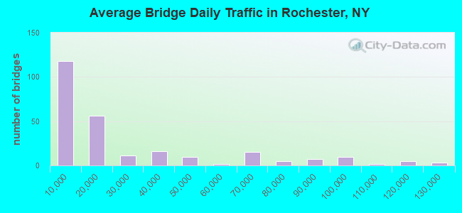
- 6,865,152Total average daily traffic
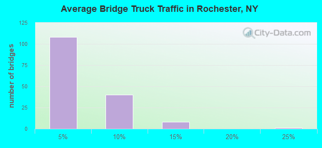
- 99,631Total average daily truck traffic
- National Bridge Inventory (NBI) Registered Bridges for Rochester
- No street view available for this location

- New bridges - historical statistics
- 11Before 1900
- 151900-1909
- 91910-1919
- 41920-1929
- 91930-1939
- 21940-1949
- 251950-1959
- 491960-1969
- 671970-1979
- 261980-1989
- 331990-1999
- 232000-2009
- 12010-2019
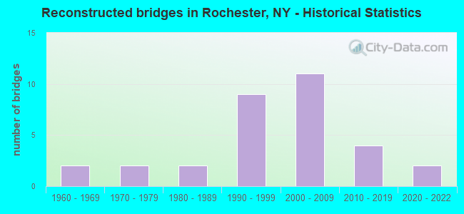
- Reconstructed bridges - Historical Statistics
- 21960-1969
- 21970-1979
- 21980-1989
- 91990-1999
- 112000-2009
- 42010-2019
- 22020-2022
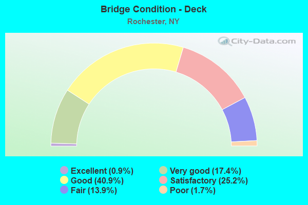
- Bridge Condition - Deck
- 0.9%Excellent
- 17.4%Very good
- 40.9%Good
- 25.2%Satisfactory
- 13.9%Fair
- 1.7%Poor

- Bridge Condition - Superstructure
- 1.7%Excellent
- 15.5%Very good
- 39.7%Good
- 28.4%Satisfactory
- 12.9%Fair
- 1.7%Poor
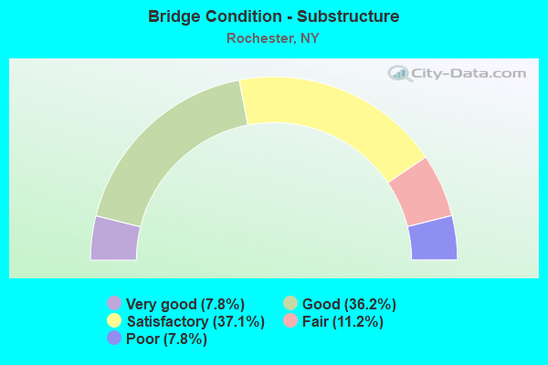
- Bridge Condition - Substructure
- 7.8%Very good
- 36.2%Good
- 37.1%Satisfactory
- 11.2%Fair
- 7.8%Poor
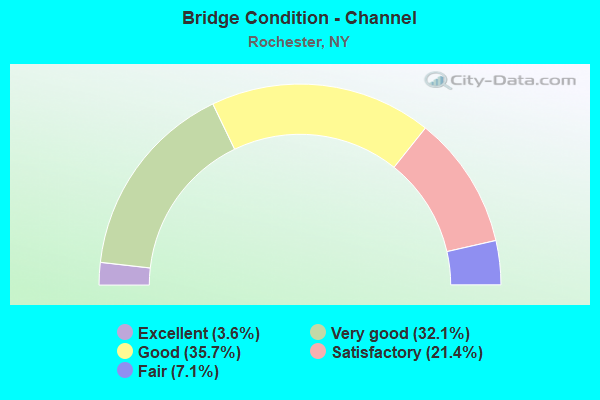
- Bridge Condition - Channel
- 3.6%Excellent
- 32.1%Very good
- 35.7%Good
- 21.4%Satisfactory
- 7.1%Fair
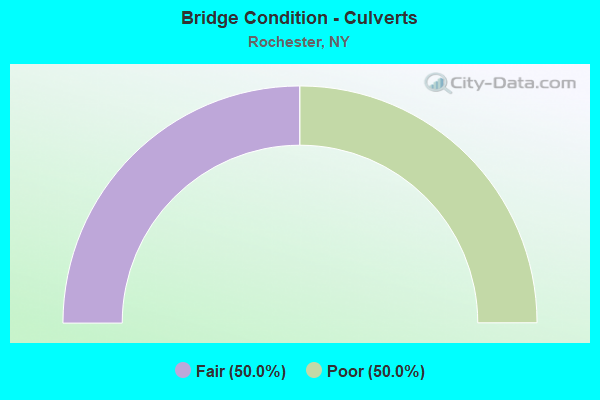
- Bridge Condition - Culverts
- 50.0%Fair
- 50.0%Poor
Find on map >> Show street view
Structure Number: 336165, Location: ONTARIO BEACH (Lat: 43.269317, Lng: -77.626503), Route carried "on" structure: County highway , Year Built: 1992, Status: Open, Structure Length: 0.88m (2.89ft), Average Daily Traffic: 1,667 (year 2018), Truck Traffic: 3%, Average Future Daily Traffic: 2,062 (year 2040), Design Load: HS 20, Features Intersected: Slater Creek, Facility Carried by Structure: Beach Avenue
Minimum Vertical Clearance: 30+ m (98+ ft), Kilometerpoint: 1.303, Lanes on structure: 2, Owner: County Highway Agency, Approaching Roadway Width: 11.6m (38.1ft), Material/Design: Prestressed concrete, Design/Construction: Box Beam or Girders - Multiple, Number Of Spans In Main Unit: 1, Length of Maximum Span: 8.5m (27.9ft), Curb or Sidewalk Widths: Left: 2.2m (7.2ft), Right: 2.2m (7.2ft), Curb-To-Curb Width: 12.2m (40.0ft), Out-to-Out Width: 16.6m (54.5ft)
Condition: Deck: Good, Superstructure: Good, Substructure: Satisfactory, Channel: Good, Operating Rating: 39.0 metric tons, Method Used To Determine Operating Rating: Load Factor (LF), Inventory Rating: 23.6 metric tons, Method Used To Determine Inventory Rating: Load Factor (LF), Structural Evaluation: Equal to present minimum criteria, Deck Geometry: Better than present minimum criteria, Waterway Adequacy: Equal to present minimum criteria, Approach Roadway Alignment: Equal to present desirable criteria, Length Of Structure Improvement: 0.88m (2.89ft), Designated Inspection Frequency: Every 24 months, Underwater Inspection Frequency: Every 60 months, Inspection Date: June 2020, Underwater Inspection Date: August 2017, Bridge Improvement Cost: $1,080,000, Roadway Improvement Cost: $632,000, Total Project Cost: $1,712,000 ( Estimate for 2021), Wearing Surface/Protective System: Wearing Surface: Bituminous, Membrane: Other
Find on map >> Show street view
Structure Number: 336818, Location: RTE 204 @ AIRPORT (Lat: 43.130739, Lng: -77.672889), Route carried "on" structure: Ramp Other road , Year Built: 1991, Status: Open, Structure Length: 4.57m (14.99ft), Truck Traffic: 6%, Design Load: HS 20, Features Intersected: RTE 204, Facility Carried by Structure: AIRPORT ACCESS RD
Minimum Vertical Clearance: 30+ m (98+ ft), Kilometerpoint: 0.290, Lanes on structure: 2, Lanes under structure: 2, Owner: County Highway Agency, Approaching Roadway Width: 11.9m (39.0ft), Material/Design: Steel, Design/Construction: Stringer/Multi-beam, Number Of Spans In Main Unit: 1, Length of Maximum Span: 44.2m (145.0ft), Curb-To-Curb Width: 11.4m (37.4ft), Out-to-Out Width: 12.4m (40.7ft)
Condition: Deck: Good, Superstructure: Good, Substructure: Satisfactory, Inventory Rating: 32.7 metric tons, Method Used To Determine Inventory Rating: Field evaluation and documented engineering judgment, Structural Evaluation: Equal to present minimum criteria, Deck Geometry: Superior to present desirable criteria, Underclear: Equal to present minimum criteria, Approach Roadway Alignment: Equal to present desirable criteria, Length Of Structure Improvement: 4.57m (14.99ft), Designated Inspection Frequency: Every 24 months, Inspection Date: July 2020, Bridge Improvement Cost: $1,990,000, Roadway Improvement Cost: $1,165,000, Total Project Cost: $3,155,000 ( Estimate for 2021), Deck Structure Type: Concrete Cast-file-Place, Wearing Surface/Protective System: Wearing Surface: Integral Concrete, Deck Protection: Epoxy Coated Reinforcing
Find on map >> Show street view
Structure Number: 336845, Location: 1 MI W JCT I390 & SH 204 (Lat: 43.128033, Lng: -77.665131), Route carried "on" structure: Ramp Other road , Year Built: 1990, Status: Open, Structure Length: 42.55m (139.60ft), Average Daily Traffic: 2,100 (year 2019), Truck Traffic: 7%, Average Future Daily Traffic: 2,940 (year 2039), Design Load: HS 20, Features Intersected: ARRIVAL ROADWAY, Facility Carried by Structure: DEPARTURE VIADUCT
Minimum Vertical Clearance: 30+ m (98+ ft), Kilometerpoint: 0.933, Lanes on structure: 3, Lanes under structure: 4, Owner: County Highway Agency, Approaching Roadway Width: 8.5m (27.9ft), Material/Design: Concrete continuous, Design/Construction: Girder and Floorbeam System, Number Of Spans In Main Unit: 19, Number Of Approach Spans: 14, Length of Maximum Span: 13.7m (44.9ft), Curb or Sidewalk Widths: Left: 2.4m (7.9ft), Right: 6.9m (22.6ft), Curb-To-Curb Width: 8.5m (27.9ft), Out-to-Out Width: 25.3m (83.0ft)
Condition: Deck: Satisfactory, Superstructure: Fair, Substructure: Satisfactory, Operating Rating: 77.3 metric tons, Method Used To Determine Operating Rating: Field evaluation and documented engineering judgment, Inventory Rating: 32.7 metric tons, Method Used To Determine Inventory Rating: Field evaluation and documented engineering judgment, Structural Evaluation: Somewhat better than minimum adequacy, Deck Geometry: High priority of replacement, Underclear: High priority of corrective action, Approach Roadway Alignment: Better than present minimum criteria, Length Of Structure Improvement: 42.55m (139.60ft), Designated Inspection Frequency: Every 24 months, Inspection Date: July 2021, Bridge Improvement Cost: $23,212,000, Roadway Improvement Cost: $13,593,000, Total Project Cost: $36,805,000 ( Estimate for 2021), Deck Structure Type: Concrete Cast-file-Place, Wearing Surface/Protective System: Wearing Surface: Monolithic Concrete
Find on map >> Show street view
Structure Number: 402589, Location: JCT RTE 47+GEN R ROCH (Lat: 43.124364, Lng: -77.633164), Route carried "on" structure: City street , Year Built: 1934, Year Reconstructed: 1984, Status: Open, Structure Length: 13.53m (44.39ft), Average Daily Traffic: 15,471 (year 2020), Truck Traffic: 2%, Average Future Daily Traffic: 15,543 (year 2040), Features Intersected: GENESEE RIVER, Facility Carried by Structure: ELMWOOD AVENUE
Minimum Vertical Clearance: 30+ m (98+ ft), Kilometerpoint: 0.499, Lanes on structure: 4, Owner: City or Municipal Highway Agency, Approaching Roadway Width: 17.7m (58.1ft), Skew: 21 degrees, Navigation Control: Yes ( Vertical Clearance: 6.0m (19.7ft), Horizontal Clearance: 28.3m (92.8ft)), Material/Design: Steel continuous, Design/Construction: Girder and Floorbeam System, Number Of Spans In Main Unit: 5, Length of Maximum Span: 32.9m (107.9ft), Curb or Sidewalk Widths: Left: 2.4m (7.9ft), Right: 2.4m (7.9ft), Curb-To-Curb Width: 17.7m (58.1ft), Out-to-Out Width: 23.2m (76.1ft)
Condition: Deck: Very good, Superstructure: Satisfactory, Substructure: Good, Channel: Very good, Operating Rating: 75.3 metric tons, Method Used To Determine Operating Rating: Load Factor (LF), Inventory Rating: 45.4 metric tons, Method Used To Determine Inventory Rating: Load Factor (LF), Structural Evaluation: Equal to present minimum criteria, Deck Geometry: Somewhat better than minimum adequacy, Waterway Adequacy: Equal to present desirable criteria, Approach Roadway Alignment: Equal to present minimum criteria, Length Of Structure Improvement: 13.53m (44.39ft), Designated Inspection Frequency: Every 24 months, Underwater Inspection Frequency: Every 60 months, Inspection Date: August 2020, Underwater Inspection Date: July 2017, Bridge Improvement Cost: $8,334,000, Roadway Improvement Cost: $4,880,000, Total Project Cost: $13,214,000 ( Estimate for 2021), Deck Structure Type: Concrete Cast-file-Place, Wearing Surface/Protective System: Wearing Surface: Monolithic Concrete, Deck Protection: Epoxy Coated Reinforcing
Find on map >> Show street view
Structure Number: 4050129, Location: JCT INNER LOOP+GENESEE R (Lat: 43.151189, Lng: -77.609817), Route carried "on" structure: Interstate 490, Year Built: 2006, Status: Open, Structure Length: 14.17m (46.49ft), Average Daily Traffic: 56,409 (year 2019), Truck Traffic: 5%, Average Future Daily Traffic: 78,447 (year 2040), Design Load: HS 25 or greater, Features Intersected: Genesee River
Minimum Vertical Clearance: 8.25m (27.07ft), Kilometerpoint: 34.610, Lanes on structure: 8, Base Highway Network: Yes, Owner: State Highway Agency, Approaching Roadway Width: 34.7m (113.8ft), Skew: 20 degrees, Navigation Control: Yes ( Vertical Clearance: 4.8m (15.7ft), Horizontal Clearance: 25.0m (82.0ft)), Material/Design: Steel, Design/Construction: Arch - Thru, Number Of Spans In Main Unit: 1, Length of Maximum Span: 132.0m (433.1ft), Curb-To-Curb Width: 34.9m (114.5ft), Out-to-Out Width: 37.2m (122.0ft)
Condition: Deck: Very good, Superstructure: Good, Substructure: Very good, Channel: Very good, Inventory Rating: 40.8 metric tons, Method Used To Determine Inventory Rating: Field evaluation and documented engineering judgment, Structural Evaluation: Better than present minimum criteria, Deck Geometry: Equal to present minimum criteria, Waterway Adequacy: Superior to present desirable criteria, Approach Roadway Alignment: Better than present minimum criteria, Length Of Structure Improvement: 14.17m (46.49ft), Designated Inspection Frequency: Every 24 months, Critical Feature Inspection Frequency: Every 24 months, Inspection Date: December 2021, Critical Feature Inspection Date: December 2021, Bridge Improvement Cost: $27,884,000, Roadway Improvement Cost: $16,329,000, Total Project Cost: $44,212,000 ( Estimate for 2021), Deck Structure Type: Concrete Cast-file-Place, Wearing Surface/Protective System: Wearing Surface: Integral Concrete, Deck Protection: Epoxy Coated Reinforcing
Find on map >> Show street view
Structure Number: 4070541, Location: JCT RTE I390 & GENESEE R (Lat: 43.120758, Lng: -77.643586), Route carried "on" structure: Interstate 390, Year Built: 1981, Status: Open, Structure Length: 62.61m (205.41ft), Truck Traffic: 6%, Design Load: HS 20+Mod, Features Intersected: GENESEE RIVER, RED CREEK
Minimum Vertical Clearance: 30+ m (98+ ft), Kilometerpoint: 25.133, Lanes on structure: 3, Base Highway Network: Yes, Owner: State Highway Agency, Approaching Roadway Width: 16.5m (54.1ft), Material/Design: Prestressed concrete continuous, Design/Construction: Segmental Box Girder, Number Of Spans In Main Unit: 11, Length of Maximum Span: 131.0m (429.8ft), Curb-To-Curb Width: 16.6m (54.5ft), Out-to-Out Width: 17.6m (57.7ft)
Condition: Deck: Satisfactory, Superstructure: Satisfactory, Substructure: Satisfactory, Channel: Satisfactory, Operating Rating: 82.6 metric tons, Method Used To Determine Operating Rating: Field evaluation and documented engineering judgment, Inventory Rating: 32.7 metric tons, Method Used To Determine Inventory Rating: Field evaluation and documented engineering judgment, Structural Evaluation: Equal to present minimum criteria, Deck Geometry: Equal to present minimum criteria, Waterway Adequacy: Equal to present desirable criteria, Approach Roadway Alignment: Equal to present desirable criteria, Length Of Structure Improvement: 62.60m (205.38ft), Designated Inspection Frequency: Every 24 months, Inspection Date: November 2020, Bridge Improvement Cost: $96,662,000, Roadway Improvement Cost: $56,605,000, Total Project Cost: $153,266,000 ( Estimate for 2021), Deck Structure Type: Concrete Cast-file-Place, Wearing Surface/Protective System: Wearing Surface: Monolithic Concrete
Find on map >> Show street view
Structure Number: 4070542, Location: JCT RTE I390 & GENESEE R (Lat: 43.120636, Lng: -77.643894), Route carried "on" structure: Interstate 390, Year Built: 1981, Status: Open, Structure Length: 63.89m (209.61ft), Average Daily Traffic: 37,863 (year 2008), Truck Traffic: 7%, Design Load: HS 20+Mod, Features Intersected: HAWTHORNE DRIVE, GENESEE
Minimum Vertical Clearance: 30+ m (98+ ft), Kilometerpoint: 25.213, Lanes on structure: 3, Base Highway Network: Yes, Owner: State Highway Agency, Approaching Roadway Width: 16.5m (54.1ft), Material/Design: Prestressed concrete continuous, Design/Construction: Segmental Box Girder, Number Of Spans In Main Unit: 11, Length of Maximum Span: 131.0m (429.8ft), Curb-To-Curb Width: 16.6m (54.5ft), Out-to-Out Width: 17.6m (57.7ft)
Condition: Deck: Good, Superstructure: Good, Substructure: Good, Channel: Very good, Operating Rating: 82.6 metric tons, Method Used To Determine Operating Rating: Field evaluation and documented engineering judgment, Inventory Rating: 32.7 metric tons, Method Used To Determine Inventory Rating: Field evaluation and documented engineering judgment, Structural Evaluation: Better than present minimum criteria, Deck Geometry: Equal to present minimum criteria, Waterway Adequacy: Equal to present desirable criteria, Approach Roadway Alignment: Equal to present desirable criteria, Length Of Structure Improvement: 63.88m (209.58ft), Designated Inspection Frequency: Every 24 months, Inspection Date: November 2020, Bridge Improvement Cost: $98,659,000, Roadway Improvement Cost: $57,774,000, Total Project Cost: $156,433,000 ( Estimate for 2021), Deck Structure Type: Concrete Cast-file-Place, Wearing Surface/Protective System: Wearing Surface: Monolithic Concrete
Find on map >> Show street view
Structure Number: 4318, Location: .2 MI SE JCT I390&GEN RVR (Lat: 43.119169, Lng: -77.640058), Route carried "on" structure: Other road , Year Built: 1981, Status: Open, Structure Length: 3.14m (10.30ft), Truck Traffic: 10%, Design Load: HS 15, Features Intersected: RED CREEK, Facility Carried by Structure: GENESEE PARK ROAD
Minimum Vertical Clearance: 30+ m (98+ ft), Kilometerpoint: 0.837, Lanes on structure: 2, Owner: City or Municipal Highway Agency, Maintenance Responsibility: Private, Approaching Roadway Width: 6.1m (20.0ft), Skew: 1 degrees, Material/Design: Prestressed concrete, Design/Construction: Box Beam or Girders - Multiple, Number Of Spans In Main Unit: 1, Length of Maximum Span: 30.4m (99.7ft), Curb or Sidewalk Widths: Left: 0.0m, Right: 1.2m (3.9ft), Curb-To-Curb Width: 6.1m (20.0ft), Out-to-Out Width: 8.1m (26.6ft)
Condition: Deck: Fair, Superstructure: Satisfactory, Substructure: Good, Channel: Very good, Operating Rating: 91.0 metric tons, Method Used To Determine Operating Rating: Load and Resistance Factor Rating (LRFR) rating reported by rating factor(RF) method using HL-93 loadings, Inventory Rating: 46.0 metric tons, Method Used To Determine Inventory Rating: Load and Resistance Factor Rating (LRFR) rating reported by rating factor(RF) method using HL-93 loadings, Structural Evaluation: Equal to present minimum criteria, Deck Geometry: Somewhat better than minimum adequacy, Waterway Adequacy: Equal to present desirable criteria, Approach Roadway Alignment: Equal to present minimum criteria, Length Of Structure Improvement: 3.13m (10.27ft), Designated Inspection Frequency: Every 24 months, Inspection Date: May 2020, Bridge Improvement Cost: $588,000, Roadway Improvement Cost: $345,000, Total Project Cost: $933,000 ( Estimate for 2021), Wearing Surface/Protective System: Wearing Surface: Integral Concrete
Find on map >> Show street view
Structure Number: 444335, Location: JCT BARGE CANAL & RTE 33 (Lat: 43.149969, Lng: -77.671628), Route carried "on" structure: State highway 33, Year Built: 1994, Status: Open, Structure Length: 5.06m (16.60ft), Average Daily Traffic: 8,973 (year 2020), Truck Traffic: 8%, Average Future Daily Traffic: 10,900 (year 2040), Design Load: HS 25 or greater, Features Intersected: ERIE CANAL
Minimum Vertical Clearance: 30+ m (98+ ft), Kilometerpoint: 22.671, Lanes on structure: 4, Base Highway Network: Yes, Owner: State Highway Agency, Approaching Roadway Width: 16.5m (54.1ft), Skew: 1 degrees, Navigation Control: Yes ( Vertical Clearance: 7.0m (23.0ft), Horizontal Clearance: 27.4m (89.9ft)), Material/Design: Steel, Design/Construction: Stringer/Multi-beam, Number Of Spans In Main Unit: 1, Length of Maximum Span: 48.8m (160.1ft), Curb or Sidewalk Widths: Left: 1.5m (4.9ft), Right: 1.5m (4.9ft), Curb-To-Curb Width: 15.8m (51.8ft), Out-to-Out Width: 19.5m (64.0ft)
Condition: Deck: Good, Superstructure: Very good, Substructure: Good, Channel: Excellent, Inventory Rating: 60.8 metric tons, Method Used To Determine Inventory Rating: Load Factor (LF), Structural Evaluation: Better than present minimum criteria, Deck Geometry: Meets minimum limits, Waterway Adequacy: Equal to present desirable criteria, Approach Roadway Alignment: Equal to present desirable criteria, Length Of Structure Improvement: 5.05m (16.57ft), Designated Inspection Frequency: Every 24 months, Inspection Date: April 2020, Bridge Improvement Cost: $2,607,000, Roadway Improvement Cost: $1,527,000, Total Project Cost: $4,134,000 ( Estimate for 2021), Deck Structure Type: Concrete Cast-file-Place, Wearing Surface/Protective System: Wearing Surface: Integral Concrete, Deck Protection: Epoxy Coated Reinforcing
Find on map >> Show street view
Structure Number: 44438, Location: CITY OF ROCHESTER (Lat: 43.142372, Lng: -77.615581), Route carried "on" structure: City street , Year Built: 1898, Year Reconstructed: 2001, Status: Open, Structure Length: 14.08m (46.19ft), Average Daily Traffic: 16,517 (year 2019), Truck Traffic: 2%, Average Future Daily Traffic: 16,594 (year 2040), Design Load: HS 25 or greater, Features Intersected: GENESEE RIVER, Facility Carried by Structure: FORD STREET
Minimum Vertical Clearance: 30+ m (98+ ft), Kilometerpoint: 0.129, Lanes on structure: 4, Owner: City or Municipal Highway Agency, Approaching Roadway Width: 15.2m (49.9ft), Navigation Control: Yes ( Vertical Clearance: 5.1m (16.7ft), Horizontal Clearance: 117.9m (386.8ft)), Material/Design: Steel continuous, Design/Construction: Stringer/Multi-beam, Number Of Spans In Main Unit: 3, Number Of Approach Spans: 1, Length of Maximum Span: 39.3m (128.9ft), Curb or Sidewalk Widths: Left: 2.4m (7.9ft), Right: 2.4m (7.9ft), Curb-To-Curb Width: 15.2m (49.9ft), Out-to-Out Width: 22.7m (74.5ft)
Condition: Deck: Good, Superstructure: Good, Substructure: Very good, Channel: Good, Operating Rating: 40.5 metric tons, Method Used To Determine Operating Rating: Load and Resistance Factor Rating (LRFR) rating reported by rating factor(RF) method using HL-93 loadings, Inventory Rating: 31.4 metric tons, Method Used To Determine Inventory Rating: Load and Resistance Factor Rating (LRFR) rating reported by rating factor(RF) method using HL-93 loadings, Structural Evaluation: Better than present minimum criteria, Deck Geometry: High priority of corrective action, Waterway Adequacy: Equal to present desirable criteria, Approach Roadway Alignment: Equal to present desirable criteria, Length Of Structure Improvement: 14.08m (46.19ft), Designated Inspection Frequency: Every 24 months, Underwater Inspection Frequency: Every 60 months, Inspection Date: September 2021, Underwater Inspection Date: August 2017, Bridge Improvement Cost: $8,392,000, Roadway Improvement Cost: $4,914,000, Total Project Cost: $13,307,000 ( Estimate for 2021), Deck Structure Type: Concrete Cast-file-Place, Wearing Surface/Protective System: Wearing Surface: Integral Concrete, Deck Protection: Galvanized Reinforcing
Find on map >> Show street view
Structure Number: 444382, Location: MAIN DR. (PARK) OVR CANAL (Lat: 43.118019, Lng: -77.636503), Route carried "on" structure: City street , Year Built: 1981, Status: Open, Structure Length: 12.31m (40.39ft), Average Daily Traffic: 1,095 (year 2020), Truck Traffic: 2%, Average Future Daily Traffic: 1,533 (year 2040), Design Load: HS 20, Features Intersected: 390I390I43012001 NB, Can, Facility Carried by Structure: MOORE DRIVE
Minimum Vertical Clearance: 30+ m (98+ ft), Kilometerpoint: 0.676, Lanes on structure: 2, Lanes under structure: 7, Owner: State Highway Agency, Approaching Roadway Width: 6.7m (22.0ft), Navigation Control: Yes ( Vertical Clearance: 6.0m (19.7ft), Horizontal Clearance: 22.8m (74.8ft)), Material/Design: Steel continuous, Design/Construction: Stringer/Multi-beam, Number Of Spans In Main Unit: 2, Length of Maximum Span: 61.3m (201.1ft), Curb or Sidewalk Widths: Left: 1.5m (4.9ft), Right: 1.5m (4.9ft), Curb-To-Curb Width: 6.7m (22.0ft), Out-to-Out Width: 10.4m (34.1ft)
Condition: Deck: Good, Superstructure: Good, Substructure: Satisfactory, Channel: Very good, Operating Rating: 92.5 metric tons, Method Used To Determine Operating Rating: Load Factor (LF), Inventory Rating: 55.3 metric tons, Method Used To Determine Inventory Rating: Load Factor (LF), Structural Evaluation: Equal to present minimum criteria, Deck Geometry: High priority of corrective action, Underclear: Meets minimum limits, Waterway Adequacy: Equal to present minimum criteria, Approach Roadway Alignment: Equal to present desirable criteria, Length Of Structure Improvement: 12.31m (40.39ft), Designated Inspection Frequency: Every 24 months, Inspection Date: September 2020, Bridge Improvement Cost: $2,989,000, Roadway Improvement Cost: $1,750,000, Total Project Cost: $4,739,000 ( Estimate for 2021), Deck Structure Type: Concrete Cast-file-Place, Wearing Surface/Protective System: Wearing Surface: Integral Concrete, Deck Protection: Epoxy Coated Reinforcing
Find on map >> Show street view
Structure Number: 101482, Location: 2.3MI E JCT RTS 104 & 47 (Lat: 43.199117, Lng: -77.635886), Route carried "under" structure: ServiceOther road , Year Built: 1960, Structure Length: 0. m, Average Daily Traffic: 50 (year 2021), Features Intersected: KODAK PARK RR, KODAK IND, Facility Carried by Structure: RTE 104
Minimum Vertical Clearance: 4.29m (14.07ft), Kilometerpoint: 0.000, Lanes on structure: 6, Lanes under structure: 2, Material/Design: Steel, Design/Construction: Stringer/Multi-beam, Length of Maximum Span: 17.0m (55.8ft)
Find on map >> Show street view
Structure Number: 101483, Location: JCT RTE 104 + GENESEE R (Lat: 43.192486, Lng: -77.620153), Route carried "under" structure: Other road , Year Built: 1931, Structure Length: 0. m, Average Daily Traffic: 5,562 (year 2015), Features Intersected: GENESEE RIVER, BRIDGE VI, Facility Carried by Structure: RTE 104
Minimum Vertical Clearance: 4.57m (14.99ft), Kilometerpoint: 0.000, Lanes on structure: 8, Lanes under structure: 3, Material/Design: Concrete, Design/Construction: Arch - Deck, Length of Maximum Span: 91.4m (299.9ft)
Find on map >> Show street view
Structure Number: 102164, Location: JCT S.H.31 & I490 (Lat: 43.142278, Lng: -77.586217), Route carried "under" structure: Interstate 490, Year Built: 1959, Structure Length: 0. m, Average Daily Traffic: 113,671 (year 2002), Features Intersected: 490I490I43022049 EB, RTE, Facility Carried by Structure: RTE 31
Minimum Vertical Clearance: 4.80m (15.75ft), Kilometerpoint: 2.237, Lanes on structure: 4, Lanes under structure: 3, Material/Design: Steel, Design/Construction: Stringer/Multi-beam, Length of Maximum Span: 24.9m (81.7ft)
Find on map >> Show street view
Structure Number: 102598, Location: .5MI S OF JCT 590I & 490I (Lat: 43.137042, Lng: -77.552997), Route carried "under" structure: Interstate 590, Year Built: 1991, Structure Length: 0. m, Average Daily Traffic: 88,614 (year 2009), Features Intersected: 590I590I43012000 NB, RTE, Facility Carried by Structure: HIGHLAND AVENUE
Minimum Vertical Clearance: 4.45m (14.60ft), Kilometerpoint: 0.000, Lanes on structure: 4, Lanes under structure: 3, Material/Design: Prestressed concrete, Design/Construction: Box Beam or Girders - Multiple, Length of Maximum Span: 25.9m (85.0ft)
Find on map >> Show street view
Structure Number: 102606, Location: 0.6MI N JCT ROL+RTE286 (Lat: 43.165839, Lng: -77.538894), Route carried "under" structure: State highway 590, Year Built: 1960, Structure Length: 0. m, Average Daily Traffic: 98,500 (year 2012), Features Intersected: 590 590 43012006 NB, RTE, Facility Carried by Structure: TRYON PARK
Minimum Vertical Clearance: 4.42m (14.50ft), Kilometerpoint: 0.965, Lanes on structure: 2, Lanes under structure: 3, Material/Design: Steel, Design/Construction: Stringer/Multi-beam, Length of Maximum Span: 17.9m (58.7ft)
Find on map >> Show street view
Structure Number: 103597, Location: INTERSEC RTS 390 & LOSP (Lat: 43.269528, Lng: -77.663894), Route carried "under" structure: Other road 947A, Year Built: 1958, Structure Length: 0. m, Average Daily Traffic: 16,556 (year 2002), Features Intersected: 947A947A43021197 WB, RTE, Facility Carried by Structure: RTE 390
Minimum Vertical Clearance: 4.57m (14.99ft), Kilometerpoint: 31.826, Lanes on structure: 2, Lanes under structure: 2, Material/Design: Concrete, Design/Construction: Slab, Length of Maximum Span: 16.2m (53.1ft)
Find on map >> Show street view
Structure Number: 1035999, Location: 6.1MI E JCT LOSP+RTE 261 (Lat: 43.261633, Lng: -77.646731), Route carried "under" structure: County highway , Year Built: 1956, Structure Length: 0. m, Average Daily Traffic: 6,776 (year 2015), Features Intersected: DEWEY AVE CR 132, Facility Carried by Structure: RTE 947A
Minimum Vertical Clearance: 4.95m (16.24ft), Kilometerpoint: 0.000, Lanes on structure: 6, Lanes under structure: 2, Material/Design: Concrete, Design/Construction: Box Beam or Girders - Multiple, Length of Maximum Span: 22.9m (75.1ft)
Find on map >> Show street view
Structure Number: 103601, Location: 2.0MI E JCT LOSP+NY 390 (Lat: 43.255678, Lng: -77.628317), Route carried "under" structure: Interstate 947A, Year Built: 1960, Structure Length: 0. m, Average Daily Traffic: 10,976 (year 2002), Features Intersected: 947A947A43011218 WB, RTE, Facility Carried by Structure: GREENLEAF ROAD
Minimum Vertical Clearance: 4.29m (14.07ft), Kilometerpoint: 35.108, Lanes on structure: 2, Lanes under structure: 2, Material/Design: Concrete continuous, Design/Construction: Frame, Length of Maximum Span: 16.7m (54.8ft)
Find on map >> Show street view
Structure Number: 1036469, Location: 3.5MI E Jct Rts 104+386 (Lat: 43.204228, Lng: -77.659106), Route carried "under" structure: State highway 940K, Year Built: 2003, Structure Length: 0. m, Average Daily Traffic: 17,597 (year 2002), Features Intersected: 940K 940K43011036 NB, RT, Facility Carried by Structure: RTE 104
Minimum Vertical Clearance: 4.60m (15.09ft), Kilometerpoint: 5.857, Lanes on structure: 6, Lanes under structure: 2, Material/Design: Steel continuous, Design/Construction: Stringer/Multi-beam, Length of Maximum Span: 27.0m (88.6ft)
Find on map >> Show street view
Structure Number: 1048729, Location: JCT I490 & MT READ BLVD (Lat: 43.157214, Lng: -77.659417), Route carried "under" structure: State highway 940K, Year Built: 2009, Structure Length: 0. m, Average Daily Traffic: 15,025 (year 2002), Features Intersected: 940K940K43011004, Ramp t, Facility Carried by Structure: RTE I490
Minimum Vertical Clearance: 4.93m (16.17ft), Kilometerpoint: 0.611, Lanes on structure: 3, Lanes under structure: 6, Material/Design: Steel, Design/Construction: Stringer/Multi-beam, Length of Maximum Span: 38.0m (124.7ft)
Find on map >> Show street view
Structure Number: 104876, Location: 0.5MI W JCT GOODMAN& I490 (Lat: 43.146356, Lng: -77.601031), Route carried "under" structure: Interstate 490, Year Built: 1959, Structure Length: 0. m, Average Daily Traffic: 119,626 (year 2002), Features Intersected: 490I490I43022040 WB, RTE, Facility Carried by Structure: ALEXANDER STREET
Minimum Vertical Clearance: 5.03m (16.50ft), Kilometerpoint: 0.772, Lanes on structure: 2, Lanes under structure: 4, Material/Design: Steel continuous, Design/Construction: Stringer/Multi-beam, Length of Maximum Span: 27.4m (89.9ft)
Find on map >> Show street view
Structure Number: 104877, Location: JCT I490 EAST + AVERILL (Lat: 43.145169, Lng: -77.600081), Route carried "under" structure: Interstate 490, Year Built: 1959, Structure Length: 0. m, Average Daily Traffic: 119,626 (year 2002), Features Intersected: 490I490I43022040 WB, RTE, Facility Carried by Structure: AVERILL AVENUE
Minimum Vertical Clearance: 5.13m (16.83ft), Kilometerpoint: 6.597, Lanes on structure: 2, Lanes under structure: 4, Material/Design: Steel continuous, Design/Construction: Stringer/Multi-beam, Length of Maximum Span: 27.4m (89.9ft)
Find on map >> Show street view
Structure Number: 104878, Location: JCT I490 EAST +MEIGS ST (Lat: 43.142597, Lng: -77.597456), Route carried "under" structure: Interstate 490, Year Built: 1959, Structure Length: 0. m, Average Daily Traffic: 79,368 (year 2002), Features Intersected: 490I490I43022040 WB, RTE, Facility Carried by Structure: MEIGS STREET
Minimum Vertical Clearance: 5.38m (17.65ft), Kilometerpoint: 2.912, Lanes on structure: 2, Lanes under structure: 4, Material/Design: Steel continuous, Design/Construction: Stringer/Multi-beam, Length of Maximum Span: 23.4m (76.8ft)
Find on map >> Show street view
Structure Number: 104879, Location: JCT I490 EAST + GOODMAN (Lat: 43.141811, Lng: -77.594783), Route carried "under" structure: Interstate 490, Year Built: 1959, Structure Length: 0. m, Average Daily Traffic: 113,671 (year 2002), Features Intersected: 490I490I43022045 WB, RTE, Facility Carried by Structure: SOUTH GOODMAN ST
Minimum Vertical Clearance: 4.88m (16.01ft), Kilometerpoint: 7.241, Lanes on structure: 4, Lanes under structure: 3, Material/Design: Steel, Design/Construction: Stringer/Multi-beam, Length of Maximum Span: 17.9m (58.7ft)
Find on map >> Show street view
Structure Number: 10488, Location: 2.2MI W JCT I490EAST+441 (Lat: 43.143133, Lng: -77.575275), Route carried "under" structure: Interstate 490, Year Built: 1959, Structure Length: 0. m, Average Daily Traffic: 86,110 (year 2005), Features Intersected: 490I490I43022055 WB, RTE, Facility Carried by Structure: CULVER ROAD
Minimum Vertical Clearance: 4.32m (14.17ft), Kilometerpoint: 0.885, Lanes on structure: 3, Lanes under structure: 3, Material/Design: Steel, Design/Construction: Stringer/Multi-beam, Length of Maximum Span: 20.1m (65.9ft)
Find on map >> Show street view
Structure Number: 104881, Location: 2.3 MI W JCT I490 & SH441 (Lat: 43.144608, Lng: -77.563014), Route carried "under" structure: Interstate , Year Built: 1991, Structure Length: 0. m, Average Daily Traffic: 500 (year 2021), Features Intersected: 490I490I43022061WB, RTE, Facility Carried by Structure: COLBY ST PEDESTRN
Minimum Vertical Clearance: 4.62m (15.16ft), Kilometerpoint: 4.135, Lanes under structure: 2, Material/Design: Prestressed concrete continuous, Design/Construction: Box Beam or Girders - Multiple, Length of Maximum Span: 24.9m (81.7ft)
Find on map >> Show street view
Structure Number: 104881, Location: 2.3 MI W JCT I490 & SH441 (Lat: 43.144608, Lng: -77.563014), Route carried "under" structure: Interstate 490, Year Built: 1991, Structure Length: 0. m, Average Daily Traffic: 79,368 (year 2002), Features Intersected: 490I490I43022061WB, RTE, Facility Carried by Structure: COLBY ST PEDESTRN
Minimum Vertical Clearance: 4.97m (16.31ft), Kilometerpoint: 4.135, Lanes under structure: 3, Material/Design: Prestressed concrete continuous, Design/Construction: Box Beam or Girders - Multiple, Length of Maximum Span: 24.9m (81.7ft)
Find on map >> Show street view
Structure Number: 1048829, Location: 1.2MI.W.JCT 490I & 441 (Lat: 43.144581, Lng: -77.555778), Route carried "under" structure: Interstate 490, Year Built: 1989, Structure Length: 0. m, Average Daily Traffic: 88,020 (year 2009), Features Intersected: 490I490I43022065 WB, RTE, Facility Carried by Structure: SOUTH WINTON ROAD
Minimum Vertical Clearance: 4.44m (14.57ft), Kilometerpoint: 10.459, Lanes on structure: 6, Lanes under structure: 4, Material/Design: Prestressed concrete continuous, Design/Construction: Box Beam or Girders - Multiple, Length of Maximum Span: 23.4m (76.8ft)
Find on map >> Show street view
Structure Number: 104977, Location: 0.7MI S JCT MT READ + 104 (Lat: 43.193911, Lng: -77.659275), Route carried "under" structure: State highway 940K, Year Built: 1954, Structure Length: 0. m, Average Daily Traffic: 16,577 (year 2002), Features Intersected: 940K940K43011029 SB, RTE, Facility Carried by Structure: RIDGEWAY AVENUE
Minimum Vertical Clearance: 4.37m (14.34ft), Kilometerpoint: 4.763, Lanes on structure: 4, Lanes under structure: 2, Material/Design: Steel, Design/Construction: Stringer/Multi-beam, Length of Maximum Span: 20.4m (66.9ft)
Find on map >> Show street view
Structure Number: 1049789, Location: .5 MI S JCT MT READ&SH104 (Lat: 43.198094, Lng: -77.659267), Route carried "under" structure: Other road , Year Built: 2006, Structure Length: 0. m, Average Daily Traffic: 25 (year 2021), Features Intersected: KODAK RAILROAD, KODAK SE, Facility Carried by Structure: RTE 940K
Minimum Vertical Clearance: 5.05m (16.57ft), Kilometerpoint: 0.000, Lanes on structure: 6, Lanes under structure: 2, Material/Design: Steel, Design/Construction: Stringer/Multi-beam, Length of Maximum Span: 18.9m (62.0ft)
Find on map >> Show street view
Structure Number: 105006, Location: JCT OF NORTH ST&I.L. (Lat: 43.162222, Lng: -77.602469), Route carried "under" structure: State highway 940T, Year Built: 1962, Structure Length: 0. m, Average Daily Traffic: 37,003 (year 2002), Features Intersected: 940T940T43011011, RTE 94, Facility Carried by Structure: NORTH STREET
Minimum Vertical Clearance: 4.83m (15.85ft), Kilometerpoint: 1.770, Lanes on structure: 4, Lanes under structure: 3, Material/Design: Steel, Design/Construction: Stringer/Multi-beam, Length of Maximum Span: 20.7m (67.9ft)
Find on map >> Show street view
Structure Number: 105007, Location: 1ST BR.E JCT CLINTON&I.L. (Lat: 43.161500, Lng: -77.607519), Route carried "under" structure: State highway 940T, Year Built: 1962, Structure Length: 0. m, Average Daily Traffic: 37,003 (year 2002), Features Intersected: 940T940T43011008 WB, RTE, Facility Carried by Structure: JOSEPH AVENUE
Minimum Vertical Clearance: 4.42m (14.50ft), Kilometerpoint: 0.129, Lanes on structure: 3, Lanes under structure: 2, Material/Design: Steel, Design/Construction: Stringer/Multi-beam, Length of Maximum Span: 21.9m (71.9ft)
Find on map >> Show street view
Structure Number: 105008, Location: JCT N. CLINTON AVE & I.L. (Lat: 43.161561, Lng: -77.608228), Route carried "under" structure: State highway 940T, Year Built: 1962, Structure Length: 0. m, Average Daily Traffic: 37,860 (year 2002), Features Intersected: 940T940T43011007 WB, RTE, Facility Carried by Structure: N CLINTON AVENUE
Minimum Vertical Clearance: 5.33m (17.49ft), Kilometerpoint: 0.113, Lanes on structure: 3, Lanes under structure: 2, Material/Design: Steel, Design/Construction: Stringer/Multi-beam, Length of Maximum Span: 26.2m (86.0ft)
Find on map >> Show street view
Structure Number: 1050099, Location: JCT OF ST PAUL ST&I.L. (Lat: 43.161517, Lng: -77.610617), Route carried "under" structure: State highway 940T, Year Built: 1962, Structure Length: 0. m, Average Daily Traffic: 31,012 (year 2014), Features Intersected: 940T940T43011006, RTE 94, Facility Carried by Structure: ST PAUL STREET
Minimum Vertical Clearance: 5.35m (17.55ft), Kilometerpoint: 0.692, Lanes on structure: 6, Lanes under structure: 2, Material/Design: Steel, Design/Construction: Stringer/Multi-beam, Length of Maximum Span: 23.4m (76.8ft)
Find on map >> Show street view
Structure Number: 1050119, Location: JCT OF I.L.& STATE ST. (Lat: 43.158658, Lng: -77.615731), Route carried "under" structure: City street , Year Built: 1952, Structure Length: 0. m, Average Daily Traffic: 13,986 (year 2009), Truck Traffic: 6%, Features Intersected: STATE STREET, Facility Carried by Structure: RTE 940T
Minimum Vertical Clearance: 4.60m (15.09ft), Kilometerpoint: 0.000, Lanes on structure: 4, Lanes under structure: 6, Material/Design: Prestressed concrete, Design/Construction: Box Beam or Girders - Multiple, Length of Maximum Span: 30.7m (100.7ft)
Find on map >> Show street view
Structure Number: 1050121, Location: WB&Ramp LA over South Ave (Lat: 43.151075, Lng: -77.607444), Route carried "under" structure: City street , Year Built: 2007, Structure Length: 0. m, Average Daily Traffic: 7,858 (year 1987), Features Intersected: Ramp Z, South Ave., Facility Carried by Structure: RTE I490
Minimum Vertical Clearance: 5.31m (17.42ft), Kilometerpoint: 0.000, Lanes on structure: 5, Lanes under structure: 2, Material/Design: Steel, Design/Construction: Stringer/Multi-beam, Length of Maximum Span: 29.9m (98.1ft)
Find on map >> Show street view
Structure Number: 1050122, Location: I 490 EB over South Avenu (Lat: 43.150894, Lng: -77.607392), Route carried "under" structure: City street , Year Built: 2006, Structure Length: 0. m, Average Daily Traffic: 4,309 (year 2015), Features Intersected: Ramp Z, South Ave, Facility Carried by Structure: RTE I490
Minimum Vertical Clearance: 4.62m (15.16ft), Kilometerpoint: 0.000, Lanes on structure: 3, Lanes under structure: 2, Material/Design: Steel continuous, Design/Construction: Stringer/Multi-beam, Length of Maximum Span: 29.8m (97.8ft)
Find on map >> Show street view
Structure Number: 105012A, Location: INNER LOOP RAMP TO I490EB (Lat: 43.150589, Lng: -77.607169), Route carried "under" structure: Interstate , Year Built: 1974, Structure Length: 0. m, Average Daily Traffic: 5,000 (year 1981), Features Intersected: Genesee Riverway Trail,, Facility Carried by Structure: RAMPS LE AND LS
Minimum Vertical Clearance: 4.90m (16.08ft), Kilometerpoint: 5.487, Lanes on structure: 2, Lanes under structure: 2, Material/Design: Steel, Design/Construction: Stringer/Multi-beam, Length of Maximum Span: 34.9m (114.5ft)
Find on map >> Show street view
Structure Number: 105012B, Location: LA RAMP I490WB TO I490EB (Lat: 43.151872, Lng: -77.607617), Route carried "under" structure: City street , Year Built: 1974, Structure Length: 0. m, Features Intersected: RAMPZ TO I490EB, J & S M, Facility Carried by Structure: RTE 940
Minimum Vertical Clearance: 4.95m (16.24ft), Kilometerpoint: 0.241, Lanes on structure: 1, Lanes under structure: 1, Material/Design: Prestressed concrete continuous, Design/Construction: Segmental Box Girder, Length of Maximum Span: 33.8m (110.9ft)
Find on map >> Show street view
Structure Number: 1050139, Location: RAMP FROM IL TO ACCESS RD (Lat: 43.151094, Lng: -77.604539), Route carried "under" structure: State highway , Year Built: 1974, Structure Length: 0. m, Average Daily Traffic: 62,500 (year 1976), Features Intersected: RAMP LB, Facility Carried by Structure: RTE 940T
Minimum Vertical Clearance: 4.37m (14.34ft), Kilometerpoint: 0.000, Lanes on structure: 4, Lanes under structure: 1, Material/Design: Steel, Design/Construction: Stringer/Multi-beam, Length of Maximum Span: 26.2m (86.0ft)
Find on map >> Show street view
Structure Number: 105016, Location: JCT E MAIN ST & I.L. (Lat: 43.159508, Lng: -77.595733), Route carried "under" structure: State highway 940T, Year Built: 1965, Structure Length: 0. m, Average Daily Traffic: 62,500 (year 1976), Features Intersected: 940T940T43011015, RTE 94, Facility Carried by Structure: EAST MAIN STREET
Minimum Vertical Clearance: 4.78m (15.68ft), Kilometerpoint: 4.280, Lanes on structure: 6, Lanes under structure: 2, Material/Design: Steel, Design/Construction: Stringer/Multi-beam, Length of Maximum Span: 13.7m (44.9ft)
Find on map >> Show street view
Structure Number: 105017, Location: .3 MI E JCT NORTH ST & IL (Lat: 43.161314, Lng: -77.597653), Route carried "under" structure: State highway 940T, Year Built: 1965, Structure Length: 0. m, Average Daily Traffic: 62,500 (year 1976), Features Intersected: 940T940T43011013 WB, RTE, Facility Carried by Structure: SCIO STREET
Minimum Vertical Clearance: 4.47m (14.67ft), Kilometerpoint: 2.092, Lanes on structure: 2, Lanes under structure: 3, Material/Design: Steel, Design/Construction: Stringer/Multi-beam, Length of Maximum Span: 24.9m (81.7ft)
Find on map >> Show street view
Structure Number: 105213, Location: INT LOSP+RTE 237 (Lat: 43.191464, Lng: -77.618014), Route carried "under" structure: State highway 104, Year Built: 1970, Structure Length: 0. m, Average Daily Traffic: 64,000 (year 2002), Features Intersected: 104 104 43032025 WB, RTE, Facility Carried by Structure: ST PAUL STREET
Minimum Vertical Clearance: 4.67m (15.32ft), Kilometerpoint: 3.894, Lanes on structure: 4, Lanes under structure: 4, Material/Design: Steel, Design/Construction: Stringer/Multi-beam, Length of Maximum Span: 20.1m (65.9ft)
Find on map >> Show street view
Structure Number: 105216, Location: 0.4MI E JCT104+GENESEE R (Lat: 43.191319, Lng: -77.612856), Route carried "under" structure: State highway 104, Year Built: 1968, Structure Length: 0. m, Average Daily Traffic: 66,527 (year 2002), Features Intersected: 104 104 43032027 WB, RTE, Facility Carried by Structure: CLINTON AVENUE
Minimum Vertical Clearance: 4.45m (14.60ft), Kilometerpoint: 4.312, Lanes on structure: 4, Lanes under structure: 3, Material/Design: Steel, Design/Construction: Stringer/Multi-beam, Length of Maximum Span: 17.0m (55.8ft)
Find on map >> Show street view
Structure Number: 105217, Location: 0.6MI E JCT104+GENESEE R (Lat: 43.191400, Lng: -77.608675), Route carried "under" structure: State highway 104, Year Built: 1969, Structure Length: 0. m, Average Daily Traffic: 66,527 (year 2002), Features Intersected: 104 104 43032029 WB, RTE, Facility Carried by Structure: SENECA AVENUE
Minimum Vertical Clearance: 4.42m (14.50ft), Kilometerpoint: 4.650, Lanes on structure: 4, Lanes under structure: 4, Material/Design: Steel, Design/Construction: Stringer/Multi-beam, Length of Maximum Span: 22.8m (74.8ft)
Find on map >> Show street view
Structure Number: 1052189, Location: 1.0MI E JCT104+GENESEE R (Lat: 43.191914, Lng: -77.599881), Route carried "under" structure: City street , Year Built: 1969, Structure Length: 0. m, Average Daily Traffic: 12,372 (year 2019), Truck Traffic: 1%, Features Intersected: HUDSON AVENUE, Facility Carried by Structure: RTE 104
Minimum Vertical Clearance: 5.72m (18.77ft), Kilometerpoint: 3.073, Lanes on structure: 8, Lanes under structure: 5, Material/Design: Steel, Design/Construction: Stringer/Multi-beam, Length of Maximum Span: 22.5m (73.8ft)
Find on map >> Show street view
Structure Number: 1052191, Location: 1.4MI E JCT104+GENESEE R (Lat: 43.193508, Lng: -77.592203), Route carried "under" structure: City street , Year Built: 1969, Structure Length: 0. m, Average Daily Traffic: 4,162 (year 2018), Truck Traffic: 2%, Features Intersected: CARTER STREET, Facility Carried by Structure: RTE 104
Minimum Vertical Clearance: 5.59m (18.34ft), Kilometerpoint: 1.979, Lanes on structure: 3, Lanes under structure: 4, Material/Design: Steel, Design/Construction: Stringer/Multi-beam, Length of Maximum Span: 19.2m (63.0ft)
Find on map >> Show street view
Structure Number: 1052192, Location: 1.4MI E JCT104+GENESEE R (Lat: 43.193306, Lng: -77.592194), Route carried "under" structure: City street , Year Built: 1969, Structure Length: 0. m, Average Daily Traffic: 4,162 (year 2018), Truck Traffic: 2%, Features Intersected: CARTER STREET, Facility Carried by Structure: RTE 104
Minimum Vertical Clearance: 4.60m (15.09ft), Kilometerpoint: 1.947, Lanes on structure: 3, Lanes under structure: 4, Material/Design: Steel, Design/Construction: Stringer/Multi-beam, Length of Maximum Span: 19.2m (63.0ft)
Find on map >> Show street view
Structure Number: 1052221, Location: 3.0MI E JCT104+GENESEE R (Lat: 43.196039, Lng: -77.561386), Route carried "under" structure: City street , Year Built: 1967, Structure Length: 0. m, Average Daily Traffic: 7,388 (year 2019), Truck Traffic: 3%, Features Intersected: CULVER ROAD, Facility Carried by Structure: RTE 104
Minimum Vertical Clearance: 4.59m (15.06ft), Kilometerpoint: 0.853, Lanes on structure: 3, Lanes under structure: 5, Material/Design: Steel, Design/Construction: Stringer/Multi-beam, Length of Maximum Span: 35.0m (114.8ft)
Find on map >> Show street view
Structure Number: 1052222, Location: 3.0MI E JCT104+GENESEE R (Lat: 43.195828, Lng: -77.561378), Route carried "under" structure: City street , Year Built: 1967, Structure Length: 0. m, Average Daily Traffic: 7,388 (year 2019), Truck Traffic: 3%, Features Intersected: CULVER ROAD, Facility Carried by Structure: RTE 104
Minimum Vertical Clearance: 4.34m (14.24ft), Kilometerpoint: 0.000, Lanes on structure: 3, Lanes under structure: 5, Material/Design: Steel, Design/Construction: Stringer/Multi-beam, Length of Maximum Span: 35.0m (114.8ft)
Find on map >> Show street view
Structure Number: 1062349, Location: 2.7MI E JCT ROL+I490 WEST (Lat: 43.157258, Lng: -77.626364), Route carried "under" structure: City street , Year Built: 1971, Structure Length: 0. m, Average Daily Traffic: 6,108 (year 2019), Truck Traffic: 3%, Features Intersected: BROWN STREET, Facility Carried by Structure: RTE I490
Minimum Vertical Clearance: 4.78m (15.68ft), Kilometerpoint: 0.981, Lanes on structure: 6, Lanes under structure: 2, Material/Design: Steel, Design/Construction: Stringer/Multi-beam, Length of Maximum Span: 28.0m (91.9ft)
Find on map >> Show street view
Structure Number: 1062359, Location: JCT I490EAST + RTE 31 (Lat: 43.157631, Lng: -77.624686), Route carried "under" structure: State highway , Year Built: 1971, Structure Length: 0. m, Average Daily Traffic: 8,515 (year 2013), Features Intersected: RTE 31X BROAD ST, Roches, Facility Carried by Structure: RTE I490
Minimum Vertical Clearance: 4.55m (14.93ft), Kilometerpoint: 4.553, Lanes on structure: 6, Lanes under structure: 4, Material/Design: Steel, Design/Construction: Stringer/Multi-beam, Length of Maximum Span: 39.3m (128.9ft)
Find on map >> Show street view
Structure Number: 1062361, Location: .3 MI W JCT I490 & W MAIN (Lat: 43.157342, Lng: -77.622558), Route carried "under" structure: City street , Year Built: 1969, Structure Length: 0. m, Average Daily Traffic: 1,762 (year 2020), Truck Traffic: 3%, Features Intersected: PLATT STREET, Facility Carried by Structure: RTE I490
Minimum Vertical Clearance: 4.60m (15.09ft), Kilometerpoint: 0.064, Lanes on structure: 4, Lanes under structure: 2, Material/Design: Steel, Design/Construction: Stringer/Multi-beam, Length of Maximum Span: 27.7m (90.9ft)
Find on map >> Show street view
Structure Number: 1062362, Location: .3 MI W JCT I490 & W MAIN (Lat: 43.157139, Lng: -77.622733), Route carried "under" structure: City street , Year Built: 1969, Structure Length: 0. m, Average Daily Traffic: 1,762 (year 2020), Truck Traffic: 3%, Features Intersected: PLATT STREET, Facility Carried by Structure: RTE I490
Minimum Vertical Clearance: 4.47m (14.67ft), Kilometerpoint: 0.000, Lanes on structure: 4, Lanes under structure: 2, Material/Design: Steel, Design/Construction: Stringer/Multi-beam, Length of Maximum Span: 27.7m (90.9ft)
Find on map >> Show street view
Structure Number: 1062389, Location: 1.3MI E JCT RTS I490+ROL (Lat: 43.156992, Lng: -77.654128), Route carried "under" structure: City street , Year Built: 1971, Structure Length: 0. m, Average Daily Traffic: 5,048 (year 2020), Truck Traffic: 5%, Features Intersected: GLIDE STREET, Facility Carried by Structure: RTE I490
Minimum Vertical Clearance: 4.27m (14.01ft), Kilometerpoint: 0.000, Lanes on structure: 8, Lanes under structure: 2, Material/Design: Steel, Design/Construction: Stringer/Multi-beam, Length of Maximum Span: 30.5m (100.1ft)
Find on map >> Show street view
Structure Number: 10624, Location: 1.9MI E JCT RTS I490+ROL (Lat: 43.157047, Lng: -77.643964), Route carried "under" structure: Interstate 490, Year Built: 1971, Structure Length: 0. m, Average Daily Traffic: 106,370 (year 2002), Features Intersected: 490I490I43022015 WB, RTE, Facility Carried by Structure: AMES STREET
Minimum Vertical Clearance: 5.00m (16.40ft), Kilometerpoint: 2.462, Lanes on structure: 3, Lanes under structure: 3, Material/Design: Steel continuous, Design/Construction: Stringer/Multi-beam, Length of Maximum Span: 21.0m (68.9ft)
Find on map >> Show street view
Structure Number: 106241, Location: 2 MI E JCT I490 & R.O.L. (Lat: 43.156706, Lng: -77.641189), Route carried "under" structure: Interstate 490, Year Built: 1971, Structure Length: 0. m, Average Daily Traffic: 106,370 (year 2002), Features Intersected: 490I490I43022016, RTE I4, Facility Carried by Structure: COLVIN ST PEDESTR
Minimum Vertical Clearance: 4.72m (15.49ft), Kilometerpoint: 2.655, Lanes under structure: 7, Material/Design: Steel continuous, Design/Construction: Stringer/Multi-beam, Length of Maximum Span: 30.1m (98.8ft)
Find on map >> Show street view
Structure Number: 106241, Location: 2 MI E JCT I490 & R.O.L. (Lat: 43.156706, Lng: -77.641189), Route carried "under" structure: Interstate , Year Built: 1971, Structure Length: 0. m, Features Intersected: 490I490I43022016, RTE I4, Facility Carried by Structure: COLVIN ST PEDESTR
Minimum Vertical Clearance: 4.72m (15.49ft), Kilometerpoint: 2.655, Lanes under structure: 4, Material/Design: Steel continuous, Design/Construction: Stringer/Multi-beam, Length of Maximum Span: 30.1m (98.8ft)
Find on map >> Show street view
Structure Number: 106242, Location: 2.2 MI E JCT I490 & ROL (Lat: 43.156692, Lng: -77.638881), Route carried "under" structure: Interstate 490, Year Built: 1971, Structure Length: 0. m, Average Daily Traffic: 95,332 (year 2002), Features Intersected: 490I490I43022017, RTE I4, Facility Carried by Structure: CHILD STREET
Minimum Vertical Clearance: 4.57m (14.99ft), Kilometerpoint: 2.848, Lanes on structure: 3, Lanes under structure: 3, Material/Design: Steel continuous, Design/Construction: Stringer/Multi-beam, Length of Maximum Span: 28.6m (93.8ft)
Find on map >> Show street view
Structure Number: 106243, Location: 2.5MI E JCT RTS I490+ROL (Lat: 43.156508, Lng: -77.632314), Route carried "under" structure: Interstate 490, Year Built: 1971, Structure Length: 0. m, Average Daily Traffic: 95,332 (year 2002), Features Intersected: 490I490I43022021 WB, RTE, Facility Carried by Structure: SAXTON STREET
Minimum Vertical Clearance: 4.60m (15.09ft), Kilometerpoint: 3.363, Lanes on structure: 2, Lanes under structure: 4, Material/Design: Steel continuous, Design/Construction: Stringer/Multi-beam, Length of Maximum Span: 24.0m (78.7ft)
Find on map >> Show street view
Structure Number: 106244, Location: 2.7MI E JCT RTS I490+ROL (Lat: 43.156717, Lng: -77.629056), Route carried "under" structure: Interstate 490, Year Built: 1971, Structure Length: 0. m, Average Daily Traffic: 95,332 (year 2002), Features Intersected: 490I490I43022022 WB, RTE, Facility Carried by Structure: GRAPE STREET
Minimum Vertical Clearance: 4.65m (15.26ft), Kilometerpoint: 3.652, Lanes on structure: 2, Lanes under structure: 4, Material/Design: Steel continuous, Design/Construction: Stringer/Multi-beam, Length of Maximum Span: 31.3m (102.7ft)
Find on map >> Show street view
Structure Number: 106251, Location: 1.2MI S JCT ROL + 104 (Lat: 43.191281, Lng: -77.683086), Route carried "under" structure: State highway 390, Year Built: 1971, Structure Length: 0. m, Average Daily Traffic: 88,393 (year 2015), Features Intersected: 390 390 43011023, RTE 39, Facility Carried by Structure: RIDGEWAY AVENUE
Minimum Vertical Clearance: 4.50m (14.76ft), Kilometerpoint: 3.749, Lanes on structure: 4, Lanes under structure: 4, Material/Design: Steel, Design/Construction: Stringer/Multi-beam, Length of Maximum Span: 30.4m (99.7ft)
Find on map >> Show street view
Structure Number: 106386, Location: 0.3MI E JCT RTE104+GEN R (Lat: 43.191283, Lng: -77.615297), Route carried "under" structure: State highway 104, Year Built: 1968, Structure Length: 0. m, Average Daily Traffic: 64,000 (year 2002), Features Intersected: 104 104 43032026 WB, RTE, Facility Carried by Structure: HOLLENBECK STREET
Minimum Vertical Clearance: 4.32m (14.17ft), Kilometerpoint: 4.119, Lanes on structure: 2, Lanes under structure: 4, Material/Design: Steel, Design/Construction: Stringer/Multi-beam, Length of Maximum Span: 24.6m (80.7ft)
Find on map >> Show street view
Structure Number: 106387, Location: SOUTH AVE TO EB I490 RAMP (Lat: 43.149386, Lng: -77.606417), Route carried "under" structure: Ramp Interstate 490, Year Built: 1971, Structure Length: 0. m, Average Daily Traffic: 20,000 (year 1974), Features Intersected: RTE I490, Facility Carried by Structure: RTE 15
Minimum Vertical Clearance: 4.39m (14.40ft), Kilometerpoint: 5.519, Lanes on structure: 4, Lanes under structure: 1, Material/Design: Steel, Design/Construction: Stringer/Multi-beam, Length of Maximum Span: 26.8m (87.9ft)
Find on map >> Show street view
Structure Number: 1064009, Location: JCT INNER LOOP+PLYMOUTH (Lat: 43.157525, Lng: -77.617608), Route carried "under" structure: City street , Year Built: 1971, Structure Length: 0. m, Average Daily Traffic: 15,000 (year 1972), Features Intersected: PLYMOUTH AVENUE, Facility Carried by Structure: RTE 940T
Minimum Vertical Clearance: 4.65m (15.26ft), Kilometerpoint: 0.000, Lanes on structure: 4, Lanes under structure: 4, Material/Design: Steel, Design/Construction: Stringer/Multi-beam, Length of Maximum Span: 28.3m (92.8ft)
Find on map >> Show street view
Structure Number: 107033, Location: .5 MI SE JCT I390 & GN RV (Lat: 43.117289, Lng: -77.635042), Route carried "under" structure: Interstate , Year Built: 1981, Structure Length: 0. m, Features Intersected: 390I 390I43031153, RTE I, Facility Carried by Structure: U OF R PEDESTRIAN
Minimum Vertical Clearance: 5.16m (16.93ft), Kilometerpoint: 0.000, Lanes under structure: 4, Material/Design: Steel continuous, Design/Construction: Stringer/Multi-beam, Length of Maximum Span: 35.7m (117.1ft)
Find on map >> Show street view
Structure Number: 107033, Location: .5 MI SE JCT I390 & GN RV (Lat: 43.117289, Lng: -77.635042), Route carried "under" structure: Interstate 390, Year Built: 1981, Structure Length: 0. m, Average Daily Traffic: 81,458 (year 2002), Features Intersected: 390I 390I43031153, RTE I, Facility Carried by Structure: U OF R PEDESTRIAN
Minimum Vertical Clearance: 4.80m (15.75ft), Kilometerpoint: 0.000, Lanes under structure: 4, Material/Design: Steel continuous, Design/Construction: Stringer/Multi-beam, Length of Maximum Span: 35.7m (117.1ft)
Find on map >> Show street view
Structure Number: 1072409, Location: 0.2 MI SW JCT RTS390&LOSP (Lat: 43.267025, Lng: -77.665533), Route carried "under" structure: Other road , Year Built: 1983, Structure Length: 0. m, Average Daily Traffic: 1,793 (year 2019), Truck Traffic: 4%, Features Intersected: JANES ROAD, Facility Carried by Structure: RTE 390
Minimum Vertical Clearance: 4.65m (15.26ft), Kilometerpoint: 0.000, Lanes on structure: 4, Lanes under structure: 2, Material/Design: Steel, Design/Construction: Stringer/Multi-beam, Length of Maximum Span: 33.8m (110.9ft)
Find on map >> Show street view
Structure Number: 107241, Location: 0.1MI E INTER RT 390&LOSP (Lat: 43.267836, Lng: -77.661414), Route carried "under" structure: State highway 947A, Year Built: 1983, Structure Length: 0. m, Average Daily Traffic: 16,556 (year 2002), Features Intersected: LOSP Multi-Use Trail, 94, Facility Carried by Structure: ISLAND COTTAGE RD
Minimum Vertical Clearance: 4.75m (15.58ft), Kilometerpoint: 32.116, Lanes on structure: 2, Lanes under structure: 3, Material/Design: Steel, Design/Construction: Stringer/Multi-beam, Length of Maximum Span: 44.5m (146.0ft)
Find on map >> Show street view
Structure Number: 107383, Location: .1MI NW INTER.IN.LP & 33 (Lat: 43.160889, Lng: -77.596856), Route carried "under" structure: Interstate 940T, Year Built: 1988, Structure Length: 0. m, Average Daily Traffic: 5,944 (year 2014), Features Intersected: RTE 940T
Minimum Vertical Clearance: 4.52m (14.83ft), Kilometerpoint: 2.735, Lanes on structure: 1, Lanes under structure: 2, Material/Design: Steel, Design/Construction: Stringer/Multi-beam, Length of Maximum Span: 44.1m (144.7ft)
Find on map >> Show street view
Structure Number: 107406, Location: JCT I590 NB & I490, I590 (Lat: 43.142764, Lng: -77.551072), Route carried "under" structure: Interstate 590, Year Built: 1990, Structure Length: 0. m, Average Daily Traffic: 43,759 (year 2009), Features Intersected: 590I590I43012004 SB, RTE, Facility Carried by Structure: RAMP NEW
Minimum Vertical Clearance: 7.62m (25.00ft), Kilometerpoint: 0.000, Lanes on structure: 2, Lanes under structure: 2, Material/Design: Steel continuous, Design/Construction: Stringer/Multi-beam, Length of Maximum Span: 54.8m (179.8ft)
Find on map >> Show street view
Structure Number: 107406, Location: JCT I590 NB & I490, I590 (Lat: 43.142764, Lng: -77.551072), Route carried "under" structure: Interstate , Year Built: 1990, Structure Length: 0. m, Average Daily Traffic: 10,101 (year 2009), Features Intersected: 590I590I43012004 SB, RTE, Facility Carried by Structure: RAMP NEW
Minimum Vertical Clearance: 5.03m (16.50ft), Kilometerpoint: 0.000, Lanes on structure: 2, Lanes under structure: 1, Material/Design: Steel continuous, Design/Construction: Stringer/Multi-beam, Length of Maximum Span: 54.8m (179.8ft)
Find on map >> Show street view
Structure Number: 107407, Location: JCT I490 EB & I590 NB&SB (Lat: 43.142564, Lng: -77.550381), Route carried "under" structure: Interstate 590, Year Built: 1990, Structure Length: 0. m, Average Daily Traffic: 44,765 (year 2015), Features Intersected: 590I590I43012005 NB, RTE
Minimum Vertical Clearance: 5.00m (16.40ft), Kilometerpoint: 0.805, Lanes on structure: 1, Lanes under structure: 3, Material/Design: Steel continuous, Design/Construction: Stringer/Multi-beam, Length of Maximum Span: 38.1m (125.0ft)
Find on map >> Show street view
Structure Number: 107408, Location: OVER I490 NEAR EAST AVE (Lat: 43.143967, Lng: -77.551253), Route carried "under" structure: Interstate 490, Year Built: 1990, Structure Length: 0. m, Average Daily Traffic: 44,408 (year 2009), Features Intersected: 490I490I43022067, RTE I4, Facility Carried by Structure: RAMP NW
Minimum Vertical Clearance: 4.62m (15.16ft), Kilometerpoint: 55.967, Lanes on structure: 1, Lanes under structure: 3, Material/Design: Steel continuous, Design/Construction: Stringer/Multi-beam, Length of Maximum Span: 52.1m (170.9ft)