Bridge Statistics for Salt Lake City, Utah (UT)
Condition, Traffic, Stress, Structural Evaluation, Project Costs
- National Bridge Inventory (NBI) Statistics
- 320Number of bridges
- 5,259ft / 1,603mTotal length
- $3,818,000Total costs
- 13,297,491Total average daily traffic
- 1,807,931Total average daily truck traffic
- National Bridge Inventory (NBI) Registered Bridges for Salt Lake City
- No street view available for this location
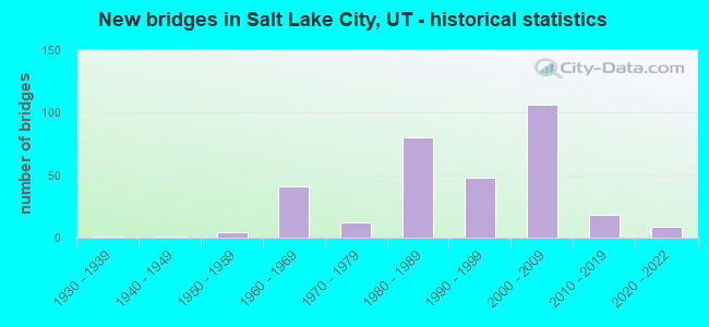
- New bridges - historical statistics
- 11930-1939
- 11940-1949
- 41950-1959
- 411960-1969
- 121970-1979
- 801980-1989
- 481990-1999
- 1062000-2009
- 182010-2019
- 92020-2022
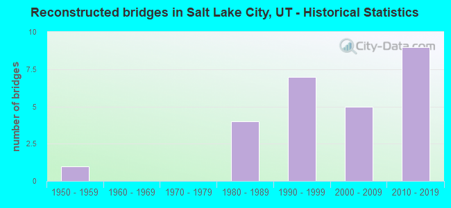
- Reconstructed bridges - Historical Statistics
- 11950-1959
- 01960-1969
- 01970-1979
- 41980-1989
- 71990-1999
- 52000-2009
- 92010-2019

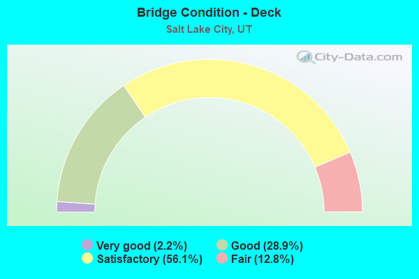
- Bridge Condition - Deck
- 2.2%Very good
- 28.9%Good
- 56.1%Satisfactory
- 12.8%Fair
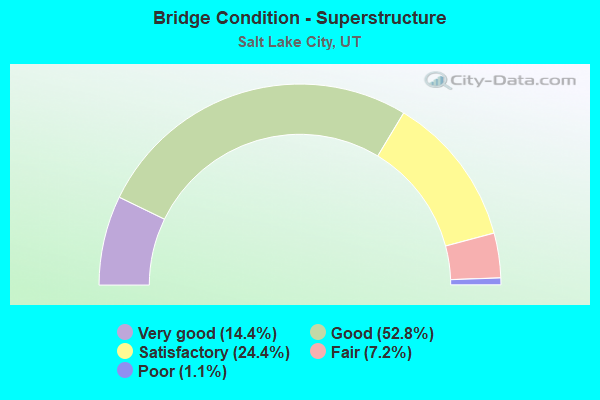
- Bridge Condition - Superstructure
- 14.4%Very good
- 52.8%Good
- 24.4%Satisfactory
- 7.2%Fair
- 1.1%Poor
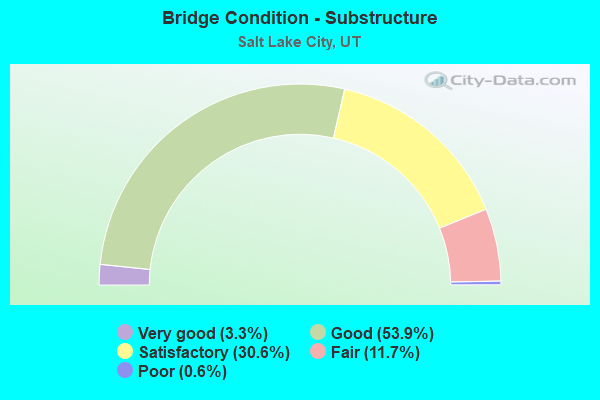
- Bridge Condition - Substructure
- 3.3%Very good
- 53.9%Good
- 30.6%Satisfactory
- 11.7%Fair
- 0.6%Poor
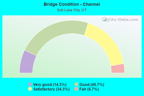
- Bridge Condition - Channel
- 14.3%Very good
- 45.7%Good
- 34.3%Satisfactory
- 5.7%Fair
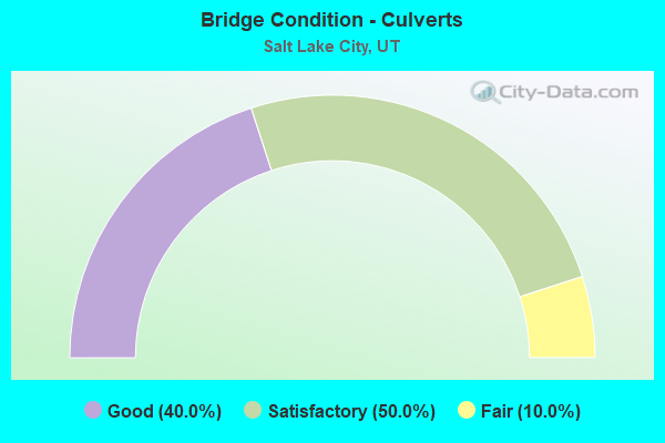
- Bridge Condition - Culverts
- 40.0%Good
- 50.0%Satisfactory
- 10.0%Fair
Find on map >> Show street view
Structure Number: C 422, Location: MOUTH OF PARLEYS CANYON (Lat: 40.714561, Lng: -111.807125), Route carried "on" structure: State highway 186, Year Built: 1966, Year Reconstructed: 2000, Status: Open, Structure Length: 5.17m (16.96ft), Average Daily Traffic: 13,623 (year 2020), Truck Traffic: 7%, Average Future Daily Traffic: 17,029 (year 2040), Design Load: HS 20+Mod, Features Intersected: I-80 (SR-80) EBL AND WB
Minimum Vertical Clearance: 30+ m (98+ ft), Kilometerpoint: 0.499, Lanes on structure: 5, Lanes under structure: 5, Base Highway Network: Yes (Inventory Route: 186PR0, Subroute: 6), Owner: State Highway Agency, Approaching Roadway Width: 24.4m (80.1ft), Skew: 33 degrees, Material/Design: Steel, Design/Construction: Stringer/Multi-beam, Number Of Spans In Main Unit: 4, Length of Maximum Span: 28.4m (93.2ft), Curb-To-Curb Width: 23.6m (77.4ft), Out-to-Out Width: 41.7m (136.8ft)
Condition: Deck: Fair, Superstructure: Good, Substructure: Fair, Operating Rating: 50.9 metric tons, Method Used To Determine Operating Rating: Load and Resistance Factor Rating (LRFR) rating reported by rating factor(RF) method using HL-93 loadings, Inventory Rating: 34.3 metric tons, Method Used To Determine Inventory Rating: Load Factor (LF) rating reported by rating factor (RF) method using MS18 loading, Structural Evaluation: Somewhat better than minimum adequacy, Deck Geometry: Better than present minimum criteria, Underclear: High priority of corrective action, Approach Roadway Alignment: Equal to present desirable criteria, Designated Inspection Frequency: Every 26 months, Inspection Date: June 2020, Deck Structure Type: Concrete Cast-file-Place, Wearing Surface/Protective System: Wearing Surface: Bituminous
Find on map >> Show street view
Structure Number: C 46, Location: 2000 W. 850 SO. IN SLC (Lat: 40.751211, Lng: -111.948494), Route carried "on" structure: Interstate 215, Year Built: 1988, Status: Open, Structure Length: 6.91m (22.67ft), Average Daily Traffic: 87,424 (year 2020), Truck Traffic: 14%, Average Future Daily Traffic: 109,280 (year 2040), Design Load: HS 20+Mod, Features Intersected: INDIANA AVE and UPRR S
Minimum Vertical Clearance: 30+ m (98+ ft), Kilometerpoint: 34.347, Lanes on structure: 10, Lanes under structure: 3, Base Highway Network: Yes, Owner: State Highway Agency, Approaching Roadway Width: 47.9m (157.2ft), Skew: 31 degrees, Material/Design: Steel continuous, Design/Construction: Stringer/Multi-beam, Number Of Spans In Main Unit: 3, Length of Maximum Span: 46.9m (153.9ft), Curb-To-Curb Width: 47.9m (157.2ft), Out-to-Out Width: 49.5m (162.4ft)
Condition: Deck: Satisfactory, Superstructure: Good, Substructure: Satisfactory, Operating Rating: 32.4 metric tons, Method Used To Determine Operating Rating: Load Factor (LF) rating reported by rating factor (RF) method using MS18 loading, Inventory Rating: 25.6 metric tons, Method Used To Determine Inventory Rating: Load Factor (LF) rating reported by rating factor (RF) method using MS18 loading, Structural Evaluation: Equal to present minimum criteria, Deck Geometry: Superior to present desirable criteria, Underclear: Superior to present desirable criteria, Approach Roadway Alignment: Equal to present desirable criteria, Designated Inspection Frequency: Every 24 months, Inspection Date: December 2020, Deck Structure Type: Concrete Cast-file-Place, Wearing Surface/Protective System: Wearing Surface: Bituminous, Membrane: Preformed Fabric, Deck Protection: Epoxy Coated Reinforcing
Find on map >> Show street view
Structure Number: C 518, Location: 3900 SO. & WASATCH BL (Lat: 40.687314, Lng: -111.797636), Route carried "on" structure: Interstate 215, Year Built: 1971, Year Reconstructed: 2004, Status: Open, Structure Length: 5.66m (18.57ft), Average Daily Traffic: 62,877 (year 2020), Truck Traffic: 12%, Average Future Daily Traffic: 78,596 (year 2040), Design Load: HS 20+Mod, Features Intersected: 3900 SOUTH STREET
Minimum Vertical Clearance: 30+ m (98+ ft), Kilometerpoint: 4.383, Lanes on structure: 7, Lanes under structure: 6, Base Highway Network: Yes, Owner: State Highway Agency, Approaching Roadway Width: 31.7m (104.0ft), Skew: 30 degrees, Material/Design: Steel continuous, Design/Construction: Stringer/Multi-beam, Number Of Spans In Main Unit: 3, Length of Maximum Span: 40.1m (131.6ft), Curb-To-Curb Width: 40.2m (131.9ft), Out-to-Out Width: 42.0m (137.8ft)
Condition: Deck: Satisfactory, Superstructure: Satisfactory, Substructure: Satisfactory, Operating Rating: 55.4 metric tons, Method Used To Determine Operating Rating: Load and Resistance Factor Rating (LRFR) rating reported by rating factor(RF) method using HL-93 loadings, Inventory Rating: 52.8 metric tons, Method Used To Determine Inventory Rating: Load Factor (LF) rating reported by rating factor (RF) method using MS18 loading, Structural Evaluation: Equal to present minimum criteria, Deck Geometry: Superior to present desirable criteria, Underclear: Equal to present desirable criteria, Approach Roadway Alignment: Equal to present desirable criteria, Designated Inspection Frequency: Every 24 months, Inspection Date: September 2020, Deck Structure Type: Concrete Precast Panels, Wearing Surface/Protective System: Wearing Surface: Epoxy Overlay, Deck Protection: Epoxy Coated Reinforcing
Find on map >> Show street view
Structure Number: C 635, Location: 7200 WEST INTERCHANGE (Lat: 40.770603, Lng: -112.063058), Route carried "on" structure: ServiceInterstate 80, Year Built: 1982, Status: Open, Structure Length: 7.32m (24.02ft), Average Daily Traffic: 7,905 (year 2020), Truck Traffic: 58%, Average Future Daily Traffic: 9,881 (year 2040), Design Load: HS 20+Mod, Features Intersected: I-80 (SR-80), Facility Carried by Structure: CO. RD. INT X-ROAD
Minimum Vertical Clearance: 5.07m (16.63ft), Kilometerpoint: 0.121, Lanes on structure: 2, Lanes under structure: 4, Owner: State Highway Agency, Approaching Roadway Width: 17.1m (56.1ft), Skew: 20 degrees, Material/Design: Steel continuous, Design/Construction: Stringer/Multi-beam, Number Of Spans In Main Unit: 2, Length of Maximum Span: 37.2m (122.0ft), Curb-To-Curb Width: 17.9m (58.7ft), Out-to-Out Width: 18.9m (62.0ft)
Condition: Deck: Satisfactory, Superstructure: Good, Substructure: Good, Operating Rating: 42.4 metric tons, Method Used To Determine Operating Rating: Load and Resistance Factor Rating (LRFR) rating reported by rating factor(RF) method using HL-93 loadings, Inventory Rating: 31.8 metric tons, Method Used To Determine Inventory Rating: Load Factor (LF) rating reported by rating factor (RF) method using MS18 loading, Structural Evaluation: Better than present minimum criteria, Deck Geometry: Superior to present desirable criteria, Underclear: Equal to present minimum criteria, Approach Roadway Alignment: Equal to present desirable criteria, Designated Inspection Frequency: Every 24 months, Inspection Date: November 2020, Deck Structure Type: Concrete Cast-file-Place, Wearing Surface/Protective System: Wearing Surface: Monolithic Concrete, Deck Protection: Epoxy Coated Reinforcing
Find on map >> Show street view
Structure Number: C 669, Location: 5600 WEST INTERCHANGE (Lat: 40.770683, Lng: -112.025061), Route carried "on" structure: State highway 172, Year Built: 1980, Status: Open, Structure Length: 7.64m (25.07ft), Average Daily Traffic: 18,661 (year 2020), Truck Traffic: 33%, Average Future Daily Traffic: 23,326 (year 2040), Design Load: HS 20+Mod, Features Intersected: I-80 (SR-80) EBL & W
Minimum Vertical Clearance: 30+ m (98+ ft), Kilometerpoint: 14.668, Lanes on structure: 4, Lanes under structure: 5, Base Highway Network: Yes, Owner: State Highway Agency, Approaching Roadway Width: 24.4m (80.1ft), Skew: 20 degrees, Material/Design: Steel continuous, Design/Construction: Stringer/Multi-beam, Number Of Spans In Main Unit: 2, Length of Maximum Span: 38.4m (126.0ft), Curb-To-Curb Width: 25.2m (82.7ft), Out-to-Out Width: 26.3m (86.3ft)
Condition: Deck: Fair, Superstructure: Good, Substructure: Satisfactory, Operating Rating: 54.1 metric tons, Method Used To Determine Operating Rating: Load and Resistance Factor Rating (LRFR) rating reported by rating factor(RF) method using HL-93 loadings, Inventory Rating: 43.7 metric tons, Method Used To Determine Inventory Rating: Load Factor (LF) rating reported by rating factor (RF) method using MS18 loading, Structural Evaluation: Equal to present minimum criteria, Deck Geometry: Superior to present desirable criteria, Underclear: Better than present minimum criteria, Approach Roadway Alignment: Equal to present desirable criteria, Designated Inspection Frequency: Every 24 months, Inspection Date: November 2020, Deck Structure Type: Concrete Cast-file-Place, Wearing Surface/Protective System: Wearing Surface: Epoxy Overlay, Deck Protection: Epoxy Coated Reinforcing
Find on map >> Show street view
Structure Number: C 688, Location: 500 SO.2000 WEST, SLC. (Lat: 40.757783, Lng: -111.950092), Route carried "on" structure: Interstate 215, Year Built: 1987, Status: Open, Structure Length: 5.05m (16.57ft), Average Daily Traffic: 87,424 (year 2020), Truck Traffic: 14%, Average Future Daily Traffic: 109,280 (year 2040), Design Load: HS 20+Mod, Features Intersected: 500 SOUTH STREET
Minimum Vertical Clearance: 30+ m (98+ ft), Kilometerpoint: 35.096, Lanes on structure: 6, Lanes under structure: 2, Base Highway Network: Yes, Owner: State Highway Agency, Approaching Roadway Width: 36.3m (119.1ft), Skew: 31 degrees, Material/Design: Steel, Design/Construction: Stringer/Multi-beam, Number Of Spans In Main Unit: 1, Length of Maximum Span: 49.7m (163.1ft), Curb-To-Curb Width: 41.1m (134.8ft), Out-to-Out Width: 43.8m (143.7ft)
Condition: Deck: Satisfactory, Superstructure: Good, Substructure: Good, Operating Rating: 52.5 metric tons, Method Used To Determine Operating Rating: Load and Resistance Factor Rating (LRFR) rating reported by rating factor(RF) method using HL-93 loadings, Inventory Rating: 31.4 metric tons, Method Used To Determine Inventory Rating: Load and Resistance Factor Rating (LRFR) rating reported by rating factor(RF) method using HL-93 loadings, Structural Evaluation: Better than present minimum criteria, Deck Geometry: Superior to present desirable criteria, Underclear: Superior to present desirable criteria, Approach Roadway Alignment: Equal to present desirable criteria, Designated Inspection Frequency: Every 24 months, Inspection Date: December 2020, Deck Structure Type: Concrete Cast-file-Place, Wearing Surface/Protective System: Wearing Surface: Bituminous, Membrane: Preformed Fabric, Deck Protection: Epoxy Coated Reinforcing
Find on map >> Show street view
Structure Number: C 689, Location: NO.OF 500 S0.AT 2000 W. (Lat: 40.759644, Lng: -111.950628), Route carried "on" structure: Interstate 215, Year Built: 1987, Status: Open, Structure Length: 6.60m (21.65ft), Average Daily Traffic: 87,424 (year 2020), Truck Traffic: 14%, Average Future Daily Traffic: 109,280 (year 2040), Design Load: HS 20+Mod, Features Intersected: UNION PACIFIC RAILROAD
Minimum Vertical Clearance: 30+ m (98+ ft), Kilometerpoint: 35.309, Lanes on structure: 6, Base Highway Network: Yes, Owner: State Highway Agency, Approaching Roadway Width: 35.4m (116.1ft), Skew: 31 degrees, Material/Design: Steel continuous, Design/Construction: Stringer/Multi-beam, Number Of Spans In Main Unit: 3, Length of Maximum Span: 46.9m (153.9ft), Curb-To-Curb Width: 41.1m (134.8ft), Out-to-Out Width: 43.8m (143.7ft)
Condition: Deck: Good, Superstructure: Satisfactory, Substructure: Good, Operating Rating: 54.4 metric tons, Method Used To Determine Operating Rating: Load and Resistance Factor Rating (LRFR) rating reported by rating factor(RF) method using HL-93 loadings, Inventory Rating: 37.9 metric tons, Method Used To Determine Inventory Rating: Load Factor (LF) rating reported by rating factor (RF) method using MS18 loading, Structural Evaluation: Equal to present minimum criteria, Deck Geometry: Superior to present desirable criteria, Underclear: Somewhat better than minimum adequacy, Approach Roadway Alignment: Equal to present desirable criteria, Designated Inspection Frequency: Every 24 months, Inspection Date: December 2020, Deck Structure Type: Concrete Cast-file-Place, Wearing Surface/Protective System: Wearing Surface: Bituminous, Membrane: Preformed Fabric, Deck Protection: Epoxy Coated Reinforcing
Find on map >> Show street view
Structure Number: C 692, Location: I215-I80 INTCHG.W.OF SLC. (Lat: 40.765061, Lng: -111.950469), Route carried "on" structure: Interstate 215, Year Built: 1985, Status: Open, Structure Length: 10.20m (33.46ft), Average Daily Traffic: 81,324 (year 2020), Truck Traffic: 14%, Average Future Daily Traffic: 101,655 (year 2040), Design Load: HS 20+Mod, Features Intersected: I-80 (SR-80)
Minimum Vertical Clearance: 30+ m (98+ ft), Kilometerpoint: 35.914, Lanes on structure: 6, Lanes under structure: 10, Base Highway Network: Yes, Owner: State Highway Agency, Approaching Roadway Width: 39.6m (129.9ft), Skew: 31 degrees, Material/Design: Steel continuous, Design/Construction: Stringer/Multi-beam, Number Of Spans In Main Unit: 2, Length of Maximum Span: 52.3m (171.6ft), Curb-To-Curb Width: 40.3m (132.2ft), Out-to-Out Width: 42.2m (138.5ft)
Condition: Deck: Satisfactory, Superstructure: Good, Substructure: Fair, Operating Rating: 48.9 metric tons, Method Used To Determine Operating Rating: Load and Resistance Factor Rating (LRFR) rating reported by rating factor(RF) method using HL-93 loadings, Inventory Rating: 24.0 metric tons, Method Used To Determine Inventory Rating: Load Factor (LF) rating reported by rating factor (RF) method using MS18 loading, Structural Evaluation: Somewhat better than minimum adequacy, Deck Geometry: Superior to present desirable criteria, Underclear: Equal to present minimum criteria, Approach Roadway Alignment: Equal to present desirable criteria, Designated Inspection Frequency: Every 24 months, Inspection Date: December 2020, Deck Structure Type: Concrete Cast-file-Place, Wearing Surface/Protective System: Wearing Surface: Bituminous, Membrane: Preformed Fabric, Deck Protection: Epoxy Coated Reinforcing
Find on map >> Show street view
Structure Number: C 693, Location: 2050 W.NO.TEMPLE ST. SLC. (Lat: 40.771172, Lng: -111.949097), Route carried "on" structure: Interstate 215, Year Built: 1983, Status: Open, Structure Length: 5.96m (19.55ft), Average Daily Traffic: 81,324 (year 2020), Truck Traffic: 14%, Average Future Daily Traffic: 101,655 (year 2040), Design Load: HS 20+Mod, Features Intersected: NORTH TEMPLE ST.in SLC
Minimum Vertical Clearance: 30+ m (98+ ft), Kilometerpoint: 36.603, Lanes on structure: 8, Lanes under structure: 5, Base Highway Network: Yes, Owner: State Highway Agency, Approaching Roadway Width: 49.4m (162.1ft), Skew: 30 degrees, Material/Design: Steel continuous, Design/Construction: Stringer/Multi-beam, Number Of Spans In Main Unit: 2, Length of Maximum Span: 31.2m (102.4ft), Curb-To-Curb Width: 54.6m (179.1ft), Out-to-Out Width: 61.5m (201.8ft)
Condition: Deck: Satisfactory, Superstructure: Satisfactory, Substructure: Good, Operating Rating: 38.9 metric tons, Method Used To Determine Operating Rating: Load and Resistance Factor Rating (LRFR) rating reported by rating factor(RF) method using HL-93 loadings, Inventory Rating: 33.0 metric tons, Method Used To Determine Inventory Rating: Load Factor (LF) rating reported by rating factor (RF) method using MS18 loading, Structural Evaluation: Equal to present minimum criteria, Deck Geometry: Superior to present desirable criteria, Underclear: High priority of corrective action, Approach Roadway Alignment: Equal to present desirable criteria, Designated Inspection Frequency: Every 24 months, Inspection Date: December 2020, Deck Structure Type: Concrete Cast-file-Place, Wearing Surface/Protective System: Wearing Surface: Bituminous, Membrane: Preformed Fabric, Deck Protection: Epoxy Coated Reinforcing
Find on map >> Show street view
Structure Number: C 704, Location: I215-I80 INTCHG.W.OF SLC. (Lat: 40.762111, Lng: -111.950894), Route carried "on" structure: Interstate 215, Year Built: 1985, Status: Open, Structure Length: 16.14m (52.95ft), Average Daily Traffic: 87,424 (year 2020), Truck Traffic: 14%, Average Future Daily Traffic: 109,280 (year 2040), Design Load: HS 20, Features Intersected: RP.I80W-I215S,I80E-I215N
Minimum Vertical Clearance: 30+ m (98+ ft), Kilometerpoint: 35.584, Lanes on structure: 6, Lanes under structure: 3, Base Highway Network: Yes, Owner: State Highway Agency, Approaching Roadway Width: 40.3m (132.2ft), Skew: 34 degrees, Material/Design: Steel continuous, Design/Construction: Stringer/Multi-beam, Number Of Spans In Main Unit: 2, Length of Maximum Span: 85.6m (280.8ft), Curb-To-Curb Width: 20.2m (66.3ft), Out-to-Out Width: 42.1m (138.1ft)
Condition: Deck: Satisfactory, Superstructure: Fair, Substructure: Fair, Operating Rating: 45.0 metric tons, Method Used To Determine Operating Rating: Load and Resistance Factor Rating (LRFR) rating reported by rating factor(RF) method using HL-93 loadings, Inventory Rating: 29.2 metric tons, Method Used To Determine Inventory Rating: Load and Resistance Factor Rating (LRFR) rating reported by rating factor(RF) method using HL-93 loadings, Structural Evaluation: Somewhat better than minimum adequacy, Deck Geometry: High priority of replacement, Underclear: Equal to present minimum criteria, Approach Roadway Alignment: Equal to present desirable criteria, Designated Inspection Frequency: Every 24 months, Inspection Date: December 2020, Deck Structure Type: Concrete Cast-file-Place, Wearing Surface/Protective System: Wearing Surface: Bituminous, Deck Protection: Epoxy Coated Reinforcing
Find on map >> Show street view
Structure Number: C 709, Location: 3200 W. 2100 SO. SLC (Lat: 40.726647, Lng: -111.968942), Route carried "on" structure: State highway 201, Year Built: 1980, Status: Open, Structure Length: 9.98m (32.74ft), Average Daily Traffic: 87,931 (year 2020), Truck Traffic: 20%, Average Future Daily Traffic: 109,914 (year 2040), Design Load: HS 20+Mod, Features Intersected: 3200 WEST ST. INT. X-RD.
Minimum Vertical Clearance: 30+ m (98+ ft), Kilometerpoint: 22.167, Lanes on structure: 6, Lanes under structure: 4, Base Highway Network: Yes, Owner: State Highway Agency, Approaching Roadway Width: 26.8m (87.9ft), Skew: 30 degrees, Material/Design: Steel continuous, Design/Construction: Stringer/Multi-beam, Number Of Spans In Main Unit: 3, Length of Maximum Span: 50.3m (165.0ft), Curb-To-Curb Width: 32.6m (107.0ft), Out-to-Out Width: 34.7m (113.8ft)
Condition: Deck: Satisfactory, Superstructure: Good, Substructure: Satisfactory, Operating Rating: 35.0 metric tons, Method Used To Determine Operating Rating: Load Factor (LF) rating reported by rating factor (RF) method using MS18 loading, Inventory Rating: 23.3 metric tons, Method Used To Determine Inventory Rating: Load Factor (LF) rating reported by rating factor (RF) method using MS18 loading, Structural Evaluation: Somewhat better than minimum adequacy, Deck Geometry: Superior to present desirable criteria, Underclear: Superior to present desirable criteria, Approach Roadway Alignment: Better than present minimum criteria, Designated Inspection Frequency: Every 24 months, Inspection Date: December 2020, Deck Structure Type: Concrete Cast-file-Place, Wearing Surface/Protective System: Wearing Surface: Bituminous, Membrane: Preformed Fabric, Deck Protection: Epoxy Coated Reinforcing
Find on map >> Show street view
Structure Number: C 752, Location: CALIFORNIA AVE.INTERCHG. (Lat: 40.739994, Lng: -111.949133), Route carried "on" structure: Interstate 215, Year Built: 1988, Status: Open, Structure Length: 8.41m (27.59ft), Average Daily Traffic: 87,424 (year 2020), Truck Traffic: 14%, Average Future Daily Traffic: 109,280 (year 2040), Design Load: HS 20+Mod, Features Intersected: CALIFORNIA AVE (1330 S)
Minimum Vertical Clearance: 30+ m (98+ ft), Kilometerpoint: 33.101, Lanes on structure: 8, Lanes under structure: 4, Base Highway Network: Yes, Owner: State Highway Agency, Approaching Roadway Width: 37.8m (124.0ft), Skew: 30 degrees, Material/Design: Steel, Design/Construction: Stringer/Multi-beam, Number Of Spans In Main Unit: 1, Length of Maximum Span: 83.2m (273.0ft), Curb-To-Curb Width: 47.5m (155.8ft), Out-to-Out Width: 49.4m (162.1ft)
Condition: Deck: Fair, Superstructure: Good, Substructure: Satisfactory, Operating Rating: 97.2 metric tons, Method Used To Determine Operating Rating: Load and Resistance Factor Rating (LRFR) rating reported by rating factor(RF) method using HL-93 loadings, Inventory Rating: 52.8 metric tons, Method Used To Determine Inventory Rating: Load and Resistance Factor Rating (LRFR) rating reported by rating factor(RF) method using HL-93 loadings, Structural Evaluation: Equal to present minimum criteria, Deck Geometry: Superior to present desirable criteria, Underclear: Meets minimum limits, Approach Roadway Alignment: Equal to present desirable criteria, Designated Inspection Frequency: Every 24 months, Inspection Date: December 2020, Deck Structure Type: Concrete Cast-file-Place, Wearing Surface/Protective System: Wearing Surface: Epoxy Overlay, Deck Protection: Epoxy Coated Reinforcing
Find on map >> Show street view
Structure Number: C 806, Location: 400 W.TO 600 W.ON 6TH NO. (Lat: 40.782389, Lng: -111.906639), Route carried "on" structure: State highway 268, Year Built: 1998, Status: Open, Structure Length: 29.85m (97.93ft), Average Daily Traffic: 12,890 (year 2020), Truck Traffic: 13%, Average Future Daily Traffic: 16,113 (year 2040), Design Load: HS 20+Mod, Features Intersected: 5TH & 6TH W. STS. &a
Minimum Vertical Clearance: 30.18m (99.02ft), Kilometerpoint: 0.620, Lanes on structure: 5, Lanes under structure: 4, Owner: State Highway Agency, Approaching Roadway Width: 26.7m (87.6ft), Skew: 30 degrees, Material/Design: Steel continuous, Design/Construction: Stringer/Multi-beam, Number Of Spans In Main Unit: 4, Number Of Approach Spans: 1, Length of Maximum Span: 68.0m (223.1ft), Curb or Sidewalk Widths: Left: 2.0m (6.6ft), Right: 0.0m, Curb-To-Curb Width: 26.7m (87.6ft), Out-to-Out Width: 30.7m (100.7ft)
Condition: Deck: Satisfactory, Superstructure: Good, Substructure: Satisfactory, Operating Rating: 45.0 metric tons, Method Used To Determine Operating Rating: Load and Resistance Factor Rating (LRFR) rating reported by rating factor(RF) method using HL-93 loadings, Inventory Rating: 44.1 metric tons, Method Used To Determine Inventory Rating: Load Factor (LF) rating reported by rating factor (RF) method using MS18 loading, Structural Evaluation: Equal to present minimum criteria, Deck Geometry: Superior to present desirable criteria, Underclear: Somewhat better than minimum adequacy, Approach Roadway Alignment: Equal to present desirable criteria, Designated Inspection Frequency: Every 26 months, Inspection Date: May 2020, Deck Structure Type: Concrete Cast-file-Place, Wearing Surface/Protective System: Wearing Surface: Epoxy Overlay, Deck Protection: Epoxy Coated Reinforcing
Find on map >> Show street view
Structure Number: C 816, Location: 600 NO.INTERCHANGE IN SLC (Lat: 40.782372, Lng: -111.911247), Route carried "on" structure: State highway 268, Year Built: 1998, Status: Open, Structure Length: 6.52m (21.39ft), Average Daily Traffic: 12,890 (year 2020), Truck Traffic: 13%, Average Future Daily Traffic: 16,113 (year 2040), Design Load: HS 20+Mod, Features Intersected: I-15 (SR-15) NBL & S
Minimum Vertical Clearance: 5.61m (18.41ft), Kilometerpoint: 0.231, Lanes on structure: 6, Lanes under structure: 12, Owner: State Highway Agency, Approaching Roadway Width: 45.0m (147.6ft), Skew: 1 degrees, Material/Design: Steel continuous, Design/Construction: Stringer/Multi-beam, Number Of Spans In Main Unit: 2, Length of Maximum Span: 32.2m (105.6ft), Curb or Sidewalk Widths: Left: 0.0m, Right: 1.9m (6.2ft), Curb-To-Curb Width: 55.0m (180.4ft), Out-to-Out Width: 72.6m (238.2ft)
Condition: Deck: Satisfactory, Superstructure: Good, Substructure: Good, Operating Rating: 72.3 metric tons, Method Used To Determine Operating Rating: Load and Resistance Factor Rating (LRFR) rating reported by rating factor(RF) method using HL-93 loadings, Inventory Rating: 53.8 metric tons, Method Used To Determine Inventory Rating: Load and Resistance Factor Rating (LRFR) rating reported by rating factor(RF) method using HL-93 loadings, Structural Evaluation: Better than present minimum criteria, Deck Geometry: Superior to present desirable criteria, Underclear: Somewhat better than minimum adequacy, Approach Roadway Alignment: Equal to present desirable criteria, Designated Inspection Frequency: Every 26 months, Inspection Date: May 2020, Deck Structure Type: Concrete Cast-file-Place, Wearing Surface/Protective System: Wearing Surface: Epoxy Overlay, Deck Protection: Epoxy Coated Reinforcing
Find on map >> Show street view
Structure Number: C 968, Location: At 3300 So.Int.with I-215 (Lat: 40.699844, Lng: -111.795589), Route carried "on" structure: State highway 171, Year Built: 2008, Status: Open, Structure Length: 4.71m (15.45ft), Average Daily Traffic: 22,583 (year 2020), Truck Traffic: 5%, Average Future Daily Traffic: 28,229 (year 2040), Design Load: HL 93, Features Intersected: I-215 NB AND SB
Minimum Vertical Clearance: 30+ m (98+ ft), Kilometerpoint: 25.111, Lanes on structure: 4, Lanes under structure: 6, Owner: State Highway Agency, Approaching Roadway Width: 17.6m (57.7ft), Material/Design: Steel, Design/Construction: Stringer/Multi-beam, Number Of Spans In Main Unit: 1, Length of Maximum Span: 46.6m (152.9ft), Curb or Sidewalk Widths: Left: 0.0m, Right: 1.8m (5.9ft), Curb-To-Curb Width: 17.6m (57.7ft), Out-to-Out Width: 21.9m (71.9ft)
Condition: Deck: Good, Superstructure: Very good, Substructure: Good, Operating Rating: 46.7 metric tons, Method Used To Determine Operating Rating: Load and Resistance Factor Rating (LRFR) rating reported by rating factor(RF) method using HL-93 loadings, Inventory Rating: 32.7 metric tons, Method Used To Determine Inventory Rating: Load and Resistance Factor Rating (LRFR) rating reported by rating factor(RF) method using HL-93 loadings, Structural Evaluation: Better than present minimum criteria, Deck Geometry: Somewhat better than minimum adequacy, Underclear: High priority of corrective action, Approach Roadway Alignment: Equal to present desirable criteria, Designated Inspection Frequency: Every 26 months, Inspection Date: June 2020, Deck Structure Type: Concrete Cast-file-Place, Wearing Surface/Protective System: Wearing Surface: Epoxy Overlay, Deck Protection: Epoxy Coated Reinforcing
Find on map >> Show street view
Structure Number: D 48, Location: 1300 SO. REDWOOD ROAD-S (Lat: 40.740008, Lng: -111.938881), Route carried "on" structure: State highway 68, Year Built: 1936, Year Reconstructed: 1959, Status: Open, Structure Length: 3.47m (11.38ft), Average Daily Traffic: 31,979 (year 2020), Truck Traffic: 16%, Average Future Daily Traffic: 39,974 (year 2040), Design Load: H 15, Features Intersected: SURPLUS CANAL
Minimum Vertical Clearance: 30.18m (99.02ft), Kilometerpoint: 92.215, Lanes on structure: 5, Owner: State Highway Agency, Approaching Roadway Width: 25.0m (82.0ft), Skew: 23 degrees, Material/Design: Concrete continuous, Design/Construction: Tee Beam, Number Of Spans In Main Unit: 3, Length of Maximum Span: 11.6m (38.1ft), Curb or Sidewalk Widths: Left: 1.6m (5.2ft), Right: 1.6m (5.2ft), Curb-To-Curb Width: 24.8m (81.4ft), Out-to-Out Width: 28.0m (91.9ft)
Condition: Deck: Good, Superstructure: Good, Substructure: Fair, Channel: Satisfactory, Operating Rating: 35.6 metric tons, Method Used To Determine Operating Rating: Load Factor (LF) rating reported by rating factor (RF) method using MS18 loading, Inventory Rating: 22.7 metric tons, Method Used To Determine Inventory Rating: Load Factor (LF) rating reported by rating factor (RF) method using MS18 loading, Structural Evaluation: Somewhat better than minimum adequacy, Deck Geometry: Superior to present desirable criteria, Waterway Adequacy: Equal to present minimum criteria, Approach Roadway Alignment: Equal to present desirable criteria, Designated Inspection Frequency: Every 17 months, Underwater Inspection Frequency: Every 60 months, Inspection Date: July 2021, Underwater Inspection Date: July 2019, Deck Structure Type: Concrete Cast-file-Place, Wearing Surface/Protective System: Wearing Surface: Bituminous
Find on map >> Show street view
Structure Number: D 564, Location: 2.5 MI.NO.OF NO.TEMPLE ST (Lat: 40.808122, Lng: -111.938997), Route carried "on" structure: State highway 68, Year Built: 1953, Status: Open, Structure Length: 2.68m (8.79ft), Average Daily Traffic: 11,280 (year 2020), Truck Traffic: 14%, Average Future Daily Traffic: 14,100 (year 2040), Design Load: H 15, Features Intersected: JORDAN RIVER
Minimum Vertical Clearance: 30+ m (98+ ft), Kilometerpoint: 99.926, Lanes on structure: 2, Owner: State Highway Agency, Approaching Roadway Width: 9.1m (29.9ft), Skew: 3 degrees, Material/Design: Concrete continuous, Design/Construction: Frame, Number Of Spans In Main Unit: 2, Length of Maximum Span: 12.2m (40.0ft), Curb or Sidewalk Widths: Left: 0.6m (2.0ft), Right: 0.6m (2.0ft), Curb-To-Curb Width: 9.2m (30.2ft), Out-to-Out Width: 11.0m (36.1ft)
Condition: Deck: Fair, Superstructure: Fair, Substructure: Satisfactory, Channel: Satisfactory, Operating Rating: 36.0 metric tons, Method Used To Determine Operating Rating: Load and Resistance Factor Rating (LRFR) rating reported by rating factor(RF) method using HL-93 loadings, Inventory Rating: 21.7 metric tons, Method Used To Determine Inventory Rating: Load and Resistance Factor Rating (LRFR) rating reported by rating factor(RF) method using HL-93 loadings, Structural Evaluation: Somewhat better than minimum adequacy, Deck Geometry: High priority of corrective action, Waterway Adequacy: Equal to present minimum criteria, Approach Roadway Alignment: Equal to present desirable criteria, Designated Inspection Frequency: Every 24 months, Inspection Date: November 2020, Deck Structure Type: Concrete Cast-file-Place, Wearing Surface/Protective System: Wearing Surface: Bituminous
Find on map >> Show street view
Structure Number: E1324, Location: 1 MI.NO.2200 NO.INTCHG. (Lat: 40.828325, Lng: -111.946853), Route carried "on" structure: Interstate 67, Year Built: 1964, Status: Open, Structure Length: 0.80m (2.62ft), Average Daily Traffic: 19,728 (year 2020), Truck Traffic: 18%, Average Future Daily Traffic: 24,660 (year 2040), Design Load: HS 20+Mod, Features Intersected: DRAINAGE CANAL, Facility Carried by Structure: I-215 (SR-215)
Minimum Vertical Clearance: 30+ m (98+ ft), Kilometerpoint: 0.067, Lanes on structure: 4, Base Highway Network: Yes, Owner: State Highway Agency, Approaching Roadway Width: 23.2m (76.1ft), Skew: 22 degrees, Material/Design: Concrete continuous, Design/Construction: Culvert, Number Of Spans In Main Unit: 2, Length of Maximum Span: 3.7m (12.1ft)
Condition: Channel: Satisfactory, Culverts: Good, Operating Rating: 68.4 metric tons, Method Used To Determine Operating Rating: Load and Resistance Factor Rating (LRFR) rating reported by rating factor(RF) method using HL-93 loadings, Inventory Rating: 68.0 metric tons, Method Used To Determine Inventory Rating: Load and Resistance Factor Rating (LRFR) rating reported by rating factor(RF) method using HL-93 loadings, Structural Evaluation: Better than present minimum criteria, Waterway Adequacy: Equal to present minimum criteria, Approach Roadway Alignment: Equal to present desirable criteria, Designated Inspection Frequency: Every 24 months, Inspection Date: December 2020
Find on map >> Show street view
Structure Number: E1709, Location: CAMPUS DRIVE.UNIV.UTAH (Lat: 40.760733, Lng: -111.850400), Route carried "on" structure: State highway 282, Year Built: 1969, Status: Open, Structure Length: 0.67m (2.20ft), Average Daily Traffic: 6,270 (year 2020), Truck Traffic: 10%, Average Future Daily Traffic: 7,838 (year 2040), Design Load: HS 20+Mod, Features Intersected: PEDESTRIAN WALKWAY
Minimum Vertical Clearance: 30+ m (98+ ft), Kilometerpoint: 0.304, Lanes on structure: 4, Owner: State Highway Agency, Maintenance Responsibility: State Agenciy, Approaching Roadway Width: 20.1m (65.9ft), Material/Design: Concrete, Design/Construction: Culvert, Number Of Spans In Main Unit: 1, Length of Maximum Span: 6.1m (20.0ft)
Condition: Culverts: Good, Operating Rating: 36.3 metric tons, Method Used To Determine Operating Rating: Load Factor (LF) rating reported by rating factor (RF) method using MS18 loading, Inventory Rating: 22.0 metric tons, Method Used To Determine Inventory Rating: Load Factor (LF) rating reported by rating factor (RF) method using MS18 loading, Structural Evaluation: Somewhat better than minimum adequacy, Approach Roadway Alignment: Equal to present desirable criteria, Designated Inspection Frequency: Every 26 months, Inspection Date: June 2020
Find on map >> Show street view
Structure Number: E1908, Location: 2800 WEST 2100 SOUTH SLC (Lat: 40.725850, Lng: -111.961728), Route carried "on" structure: State highway 201, Year Built: 1972, Status: Open, Structure Length: 0.64m (2.10ft), Average Daily Traffic: 114,489 (year 2020), Truck Traffic: 20%, Average Future Daily Traffic: 143,111 (year 2040), Design Load: HS 20+Mod, Features Intersected: BRIGHTON-NO.POINT CANAL
Minimum Vertical Clearance: 30+ m (98+ ft), Kilometerpoint: 22.784, Lanes on structure: 14, Base Highway Network: Yes, Owner: State Highway Agency, Approaching Roadway Width: 39.0m (128.0ft), Skew: 25 degrees, Material/Design: Concrete, Design/Construction: Culvert, Number Of Spans In Main Unit: 1, Length of Maximum Span: 3.7m (12.1ft)
Condition: Channel: Good, Culverts: Satisfactory, Operating Rating: 57.7 metric tons, Method Used To Determine Operating Rating: Load Factor (LF) rating reported by rating factor (RF) method using MS18 loading, Inventory Rating: 32.1 metric tons, Method Used To Determine Inventory Rating: Load Factor (LF) rating reported by rating factor (RF) method using MS18 loading, Structural Evaluation: Equal to present minimum criteria, Waterway Adequacy: Equal to present desirable criteria, Approach Roadway Alignment: Equal to present desirable criteria, Designated Inspection Frequency: Every 24 months, Inspection Date: December 2020, Deck Structure Type: Concrete Cast-file-Place, Wearing Surface/Protective System: Wearing Surface: Bituminous
Find on map >> Show street view
Structure Number: E2704, Location: Social Hall Ped Underpass (Lat: 40.768197, Lng: -111.888228), Route carried "on" structure: State highway 186, Year Built: 1991, Status: Open, Structure Length: 1.34m (4.40ft), Average Daily Traffic: 27,771 (year 2020), Truck Traffic: 11%, Average Future Daily Traffic: 34,714 (year 2040), Features Intersected: City Creek Ped Underpass
Minimum Vertical Clearance: 30+ m (98+ ft), Kilometerpoint: 3.523, Lanes on structure: 6, Base Highway Network: Yes, Owner: State Highway Agency, Approaching Roadway Width: 27.7m (90.9ft), Skew: 30 degrees, Material/Design: Concrete, Design/Construction: Culvert, Number Of Spans In Main Unit: 3, Length of Maximum Span: 5.3m (17.4ft), Curb or Sidewalk Widths: Left: 5.3m (17.4ft), Right: 0.0m
Condition: Culverts: Good, Operating Rating: 43.7 metric tons, Method Used To Determine Operating Rating: Load and Resistance Factor Rating (LRFR) rating reported by rating factor(RF) method using HL-93 loadings, Inventory Rating: 38.6 metric tons, Method Used To Determine Inventory Rating: Load and Resistance Factor Rating (LRFR) rating reported by rating factor(RF) method using HL-93 loadings, Structural Evaluation: Better than present minimum criteria, Approach Roadway Alignment: Better than present minimum criteria, Designated Inspection Frequency: Every 24 months, Inspection Date: May 2020
Find on map >> Show street view
Structure Number: F 6, Location: 250 SOUTH 1400 WEST, SLC (Lat: 40.764831, Lng: -111.929781), Route carried "on" structure: Interstate 80, Year Built: 1967, Year Reconstructed: 1990, Status: Open, Structure Length: 3.88m (12.73ft), Average Daily Traffic: 56,191 (year 2020), Truck Traffic: 15%, Average Future Daily Traffic: 70,239 (year 2040), Design Load: HS 20+Mod, Features Intersected: NAVAJO STREET
Minimum Vertical Clearance: 30.18m (99.02ft), Kilometerpoint: 190.913, Lanes on structure: 6, Lanes under structure: 2, Base Highway Network: Yes, Owner: State Highway Agency, Approaching Roadway Width: 32.9m (107.9ft), Skew: 31 degrees, Material/Design: Prestressed concrete continuous, Design/Construction: Stringer/Multi-beam, Number Of Spans In Main Unit: 3, Length of Maximum Span: 14.5m (47.6ft), Curb-To-Curb Width: 33.5m (109.9ft), Out-to-Out Width: 35.4m (116.1ft)
Condition: Deck: Satisfactory, Superstructure: Good, Substructure: Satisfactory, Operating Rating: 59.0 metric tons, Method Used To Determine Operating Rating: Load and Resistance Factor Rating (LRFR) rating reported by rating factor(RF) method using HL-93 loadings, Inventory Rating: 27.9 metric tons, Method Used To Determine Inventory Rating: Load Factor (LF) rating reported by rating factor (RF) method using MS18 loading, Structural Evaluation: Equal to present minimum criteria, Deck Geometry: Superior to present desirable criteria, Underclear: Somewhat better than minimum adequacy, Approach Roadway Alignment: Equal to present desirable criteria, Designated Inspection Frequency: Every 24 months, Inspection Date: December 2020, Deck Structure Type: Concrete Cast-file-Place, Wearing Surface/Protective System: Wearing Surface: Monolithic Concrete, Deck Protection: Epoxy Coated Reinforcing
Find on map >> Show street view
Structure Number: F 7, Location: 1200 WEST 250 SOUTH, SLC (Lat: 40.764517, Lng: -111.926886), Route carried "on" structure: Interstate 80, Year Built: 1963, Year Reconstructed: 1989, Status: Open, Structure Length: 2.55m (8.37ft), Average Daily Traffic: 56,191 (year 2020), Truck Traffic: 15%, Average Future Daily Traffic: 70,239 (year 2040), Design Load: HS 20+Mod, Features Intersected: JORDAN RIVER
Minimum Vertical Clearance: 30+ m (98+ ft), Kilometerpoint: 191.160, Lanes on structure: 6, Base Highway Network: Yes, Owner: State Highway Agency, Approaching Roadway Width: 32.9m (107.9ft), Skew: 30 degrees, Material/Design: Prestressed concrete, Design/Construction: Stringer/Multi-beam, Number Of Spans In Main Unit: 1, Length of Maximum Span: 24.4m (80.1ft), Curb-To-Curb Width: 33.5m (109.9ft), Out-to-Out Width: 35.4m (116.1ft)
Condition: Deck: Fair, Superstructure: Satisfactory, Substructure: Fair, Channel: Satisfactory, Operating Rating: 51.8 metric tons, Method Used To Determine Operating Rating: Load and Resistance Factor Rating (LRFR) rating reported by rating factor(RF) method using HL-93 loadings, Inventory Rating: 30.8 metric tons, Method Used To Determine Inventory Rating: Load Factor (LF) rating reported by rating factor (RF) method using MS18 loading, Structural Evaluation: Somewhat better than minimum adequacy, Deck Geometry: Superior to present desirable criteria, Waterway Adequacy: Equal to present desirable criteria, Approach Roadway Alignment: Equal to present desirable criteria, Designated Inspection Frequency: Every 24 months, Inspection Date: December 2020, Deck Structure Type: Concrete Cast-file-Place, Wearing Surface/Protective System: Wearing Surface: Bituminous, Membrane: Preformed Fabric, Deck Protection: Epoxy Coated Reinforcing
Find on map >> Show street view
Structure Number: F 33, Location: 200 SOUTH REDWOOD RD. SLC (Lat: 40.763808, Lng: -111.939092), Route carried "on" structure: State highway 68, Year Built: 1972, Year Reconstructed: 2007, Status: Open, Structure Length: 5.66m (18.57ft), Average Daily Traffic: 21,692 (year 2020), Truck Traffic: 13%, Average Future Daily Traffic: 27,115 (year 2040), Design Load: HS 20+Mod, Features Intersected: UNION PACIFIC RAILROAD
Minimum Vertical Clearance: 30+ m (98+ ft), Kilometerpoint: 95.006, Lanes on structure: 4, Owner: State Highway Agency, Approaching Roadway Width: 25.6m (84.0ft), Skew: 32 degrees, Material/Design: Prestressed concrete, Design/Construction: Stringer/Multi-beam, Number Of Spans In Main Unit: 3, Length of Maximum Span: 28.4m (93.2ft), Curb or Sidewalk Widths: Left: 1.2m (3.9ft), Right: 1.2m (3.9ft), Curb-To-Curb Width: 25.1m (82.3ft), Out-to-Out Width: 29.1m (95.5ft)
Condition: Deck: Satisfactory, Superstructure: Satisfactory, Substructure: Fair, Operating Rating: 32.4 metric tons, Method Used To Determine Operating Rating: Load Factor (LF) rating reported by rating factor (RF) method using MS18 loading, Inventory Rating: 18.1 metric tons, Method Used To Determine Inventory Rating: Load Factor (LF) rating reported by rating factor (RF) method using MS18 loading, Structural Evaluation: Meets minimum limits, Deck Geometry: Superior to present desirable criteria, Underclear: Somewhat better than minimum adequacy, Approach Roadway Alignment: Equal to present desirable criteria, Designated Inspection Frequency: Every 24 months, Inspection Date: December 2020, Deck Structure Type: Concrete Cast-file-Place, Wearing Surface/Protective System: Wearing Surface: Integral Concrete, Deck Protection: Epoxy Coated Reinforcing
Find on map >> Show street view
Structure Number: F 34, Location: 200 SOUTH REDWOOD RD. SLC (Lat: 40.764681, Lng: -111.939114), Route carried "on" structure: State highway 68, Year Built: 1972, Year Reconstructed: 2006, Status: Open, Structure Length: 4.61m (15.12ft), Average Daily Traffic: 21,692 (year 2020), Truck Traffic: 13%, Average Future Daily Traffic: 27,115 (year 2040), Design Load: HS 20+Mod, Features Intersected: 200 SOUTH STREET
Minimum Vertical Clearance: 30+ m (98+ ft), Kilometerpoint: 95.103, Lanes on structure: 4, Lanes under structure: 2, Owner: State Highway Agency, Approaching Roadway Width: 25.6m (84.0ft), Skew: 20 degrees, Material/Design: Prestressed concrete, Design/Construction: Stringer/Multi-beam, Number Of Spans In Main Unit: 3, Length of Maximum Span: 18.0m (59.1ft), Curb or Sidewalk Widths: Left: 1.2m (3.9ft), Right: 1.2m (3.9ft), Curb-To-Curb Width: 25.1m (82.3ft), Out-to-Out Width: 29.1m (95.5ft)
Condition: Deck: Satisfactory, Superstructure: Satisfactory, Substructure: Fair, Operating Rating: 51.8 metric tons, Method Used To Determine Operating Rating: Load and Resistance Factor Rating (LRFR) rating reported by rating factor(RF) method using HL-93 loadings, Inventory Rating: 22.0 metric tons, Method Used To Determine Inventory Rating: Load Factor (LF) rating reported by rating factor (RF) method using MS18 loading, Structural Evaluation: Somewhat better than minimum adequacy, Deck Geometry: Superior to present desirable criteria, Underclear: Meets minimum limits, Approach Roadway Alignment: Equal to present desirable criteria, Designated Inspection Frequency: Every 24 months, Inspection Date: December 2020, Deck Structure Type: Concrete Cast-file-Place, Wearing Surface/Protective System: Wearing Surface: Integral Concrete
Find on map >> Show street view
Structure Number: F 35, Location: 170 SOUTH REDWOOD RD. SLC (Lat: 40.765808, Lng: -111.939119), Route carried "on" structure: State highway 68, Year Built: 1972, Year Reconstructed: 2006, Status: Open, Structure Length: 6.68m (21.92ft), Average Daily Traffic: 21,692 (year 2020), Truck Traffic: 13%, Average Future Daily Traffic: 27,115 (year 2040), Design Load: HS 20+Mod, Features Intersected: I-80 (SR-80),EBL & W
Minimum Vertical Clearance: 30+ m (98+ ft), Kilometerpoint: 95.228, Lanes on structure: 4, Lanes under structure: 6, Owner: State Highway Agency, Approaching Roadway Width: 25.6m (84.0ft), Skew: 20 degrees, Material/Design: Prestressed concrete, Design/Construction: Stringer/Multi-beam, Number Of Spans In Main Unit: 4, Length of Maximum Span: 23.2m (76.1ft), Curb or Sidewalk Widths: Left: 1.0m (3.3ft), Right: 1.0m (3.3ft), Curb-To-Curb Width: 25.0m (82.0ft), Out-to-Out Width: 29.1m (95.5ft)
Condition: Deck: Satisfactory, Superstructure: Good, Substructure: Fair, Operating Rating: 56.4 metric tons, Method Used To Determine Operating Rating: Load and Resistance Factor Rating (LRFR) rating reported by rating factor(RF) method using HL-93 loadings, Inventory Rating: 29.5 metric tons, Method Used To Determine Inventory Rating: Load and Resistance Factor Rating (LRFR) rating reported by rating factor(RF) method using HL-93 loadings, Structural Evaluation: Somewhat better than minimum adequacy, Deck Geometry: Superior to present desirable criteria, Underclear: Equal to present minimum criteria, Approach Roadway Alignment: Equal to present desirable criteria, Designated Inspection Frequency: Every 24 months, Inspection Date: December 2020, Deck Structure Type: Concrete Cast-file-Place, Wearing Surface/Protective System: Wearing Surface: Monolithic Concrete
Find on map >> Show street view
Structure Number: F 48, Location: 1300 EAST INTERCHANGE SLC (Lat: 40.719047, Lng: -111.853631), Route carried "on" structure: City street 2076, Year Built: 1964, Year Reconstructed: 1999, Status: Open, Structure Length: 6.28m (20.60ft), Average Daily Traffic: 27,890 (year 2020), Average Future Daily Traffic: 34,863 (year 2040), Design Load: HS 20+Mod, Features Intersected: I-80 (SR-80) EBL & W, Facility Carried by Structure: 1300 EAST
Minimum Vertical Clearance: 30+ m (98+ ft), Kilometerpoint: 6.713, Lanes on structure: 6, Lanes under structure: 6, Owner: State Highway Agency, Approaching Roadway Width: 31.1m (102.0ft), Skew: 20 degrees, Material/Design: Prestressed concrete, Design/Construction: Stringer/Multi-beam, Number Of Spans In Main Unit: 4, Length of Maximum Span: 23.0m (75.5ft), Curb or Sidewalk Widths: Left: 1.5m (4.9ft), Right: 1.5m (4.9ft), Curb-To-Curb Width: 26.8m (87.9ft), Out-to-Out Width: 31.7m (104.0ft)
Condition: Deck: Fair, Superstructure: Fair, Substructure: Fair, Operating Rating: 62.5 metric tons, Method Used To Determine Operating Rating: Load Factor (LF) rating reported by rating factor (RF) method using MS18 loading, Inventory Rating: 42.4 metric tons, Method Used To Determine Inventory Rating: Load Factor (LF) rating reported by rating factor (RF) method using MS18 loading, Structural Evaluation: Somewhat better than minimum adequacy, Deck Geometry: Better than present minimum criteria, Underclear: High priority of corrective action, Approach Roadway Alignment: Equal to present desirable criteria, Designated Inspection Frequency: Every 26 months, Inspection Date: June 2020, Deck Structure Type: Concrete Cast-file-Place, Wearing Surface/Protective System: Wearing Surface: Bituminous
Find on map >> Show street view
Structure Number: F 49, Location: 2400 SO & 1700 EAST (Lat: 40.718450, Lng: -111.842111), Route carried "on" structure: City street 2272, Year Built: 1964, Status: Open, Structure Length: 6.41m (21.03ft), Average Daily Traffic: 5,280 (year 2020), Average Future Daily Traffic: 6,600 (year 2040), Design Load: HS 20+Mod, Features Intersected: I-80 (SR-80) EBL & W, Facility Carried by Structure: 1700 EAST STREET
Minimum Vertical Clearance: 30.18m (99.02ft), Kilometerpoint: 0.638, Lanes on structure: 2, Lanes under structure: 6, Owner: State Highway Agency, Approaching Roadway Width: 14.6m (47.9ft), Skew: 1 degrees, Material/Design: Prestressed concrete, Design/Construction: Stringer/Multi-beam, Number Of Spans In Main Unit: 4, Length of Maximum Span: 22.1m (72.5ft), Curb or Sidewalk Widths: Left: 1.5m (4.9ft), Right: 0.0m, Curb-To-Curb Width: 14.6m (47.9ft), Out-to-Out Width: 17.4m (57.1ft)
Condition: Deck: Satisfactory, Superstructure: Poor, Substructure: Fair, Operating Rating: 50.5 metric tons, Method Used To Determine Operating Rating: Load Factor (LF) rating reported by rating factor (RF) method using MS18 loading, Inventory Rating: 32.7 metric tons, Method Used To Determine Inventory Rating: Load Factor (LF) rating reported by rating factor (RF) method using MS18 loading, Structural Evaluation: Meets minimum limits, Deck Geometry: Superior to present desirable criteria, Underclear: Meets minimum limits, Approach Roadway Alignment: Equal to present desirable criteria, Designated Inspection Frequency: Every 26 months, Inspection Date: June 2020, Deck Structure Type: Concrete Cast-file-Place, Wearing Surface/Protective System: Wearing Surface: Bituminous, Membrane: Preformed Fabric
Find on map >> Show street view
Structure Number: F 52, Location: MOUTH OF PARLEYS CANYON (Lat: 40.717208, Lng: -111.809294), Route carried "on" structure: State highway 186, Year Built: 1966, Status: Open, Structure Length: 5.16m (16.93ft), Average Daily Traffic: 13,623 (year 2020), Truck Traffic: 7%, Average Future Daily Traffic: 17,029 (year 2040), Design Load: HS 20+Mod, Features Intersected: PARLEYS WAY WB.RAMP
Minimum Vertical Clearance: 30+ m (98+ ft), Kilometerpoint: 0.151, Lanes on structure: 4, Lanes under structure: 2, Base Highway Network: Yes (Inventory Route: 186PR0, Subroute: 6), Owner: State Highway Agency, Approaching Roadway Width: 23.2m (76.1ft), Skew: 36 degrees, Material/Design: Prestressed concrete, Design/Construction: Stringer/Multi-beam, Number Of Spans In Main Unit: 3, Length of Maximum Span: 17.2m (56.4ft), Curb-To-Curb Width: 21.9m (71.9ft), Out-to-Out Width: 24.2m (79.4ft)
Condition: Deck: Good, Superstructure: Satisfactory, Substructure: Satisfactory, Operating Rating: 34.7 metric tons, Method Used To Determine Operating Rating: Load Factor (LF) rating reported by rating factor (RF) method using MS18 loading, Inventory Rating: 28.2 metric tons, Method Used To Determine Inventory Rating: Load Factor (LF) rating reported by rating factor (RF) method using MS18 loading, Structural Evaluation: Equal to present minimum criteria, Deck Geometry: Superior to present desirable criteria, Underclear: Somewhat better than minimum adequacy, Approach Roadway Alignment: Equal to present desirable criteria, Designated Inspection Frequency: Every 26 months, Inspection Date: June 2020, Deck Structure Type: Concrete Cast-file-Place, Wearing Surface/Protective System: Wearing Surface: Epoxy Overlay
Find on map >> Show street view
Structure Number: F 344, Location: SO. OF 5600 W.-I-80 INT. (Lat: 40.768367, Lng: -112.025042), Route carried "on" structure: State highway 172, Year Built: 1980, Status: Open, Structure Length: 3.87m (12.70ft), Average Daily Traffic: 18,661 (year 2020), Truck Traffic: 33%, Average Future Daily Traffic: 23,326 (year 2040), Design Load: HS 20+Mod, Features Intersected: SL&GWRR & BRIGHT
Minimum Vertical Clearance: 30+ m (98+ ft), Kilometerpoint: 14.411, Lanes on structure: 6, Base Highway Network: Yes, Owner: State Highway Agency, Approaching Roadway Width: 24.4m (80.1ft), Skew: 20 degrees, Material/Design: Prestressed concrete, Design/Construction: Stringer/Multi-beam, Number Of Spans In Main Unit: 1, Length of Maximum Span: 37.8m (124.0ft), Curb-To-Curb Width: 28.3m (92.8ft), Out-to-Out Width: 29.3m (96.1ft)
Condition: Deck: Satisfactory, Superstructure: Satisfactory, Substructure: Satisfactory, Channel: Very good, Operating Rating: 36.9 metric tons, Method Used To Determine Operating Rating: Load and Resistance Factor Rating (LRFR) rating reported by rating factor(RF) method using HL-93 loadings, Inventory Rating: 30.8 metric tons, Method Used To Determine Inventory Rating: Load and Resistance Factor Rating (LRFR) rating reported by rating factor(RF) method using HL-93 loadings, Structural Evaluation: Equal to present minimum criteria, Deck Geometry: Superior to present desirable criteria, Underclear: Equal to present minimum criteria, Waterway Adequacy: Superior to present desirable criteria, Approach Roadway Alignment: Better than present minimum criteria, Designated Inspection Frequency: Every 24 months, Inspection Date: November 2020, Deck Structure Type: Concrete Cast-file-Place, Wearing Surface/Protective System: Wearing Surface: Monolithic Concrete, Deck Protection: Epoxy Coated Reinforcing
Find on map >> Show street view
Structure Number: F 41, Location: 2000 W. 1100 SO. IN SLC (Lat: 40.746122, Lng: -111.948775), Route carried "on" structure: Interstate 215, Year Built: 1988, Status: Open, Structure Length: 12.29m (40.32ft), Average Daily Traffic: 25,500 (year 2020), Truck Traffic: 15%, Average Future Daily Traffic: 31,875 (year 2040), Design Load: HS 20+Mod, Features Intersected: SURPLUS CANAL AND RR
Minimum Vertical Clearance: 30+ m (98+ ft), Kilometerpoint: 0.696, Lanes on structure: 9, Lanes under structure: 2, Base Highway Network: Yes (Inventory Route: 215PR0, Subroute: 2), Owner: State Highway Agency, Approaching Roadway Width: 43.9m (144.0ft), Skew: 33 degrees, Material/Design: Prestressed concrete continuous, Design/Construction: Stringer/Multi-beam, Number Of Spans In Main Unit: 3, Length of Maximum Span: 42.7m (140.1ft), Curb-To-Curb Width: 50.0m (164.0ft), Out-to-Out Width: 51.9m (170.3ft)
Condition: Deck: Satisfactory, Superstructure: Good, Substructure: Satisfactory, Channel: Very good, Operating Rating: 53.1 metric tons, Method Used To Determine Operating Rating: Load and Resistance Factor Rating (LRFR) rating reported by rating factor(RF) method using HL-93 loadings, Inventory Rating: 42.4 metric tons, Method Used To Determine Inventory Rating: Load Factor (LF) rating reported by rating factor (RF) method using MS18 loading, Structural Evaluation: Equal to present minimum criteria, Deck Geometry: Superior to present desirable criteria, Underclear: Superior to present desirable criteria, Waterway Adequacy: Equal to present minimum criteria, Approach Roadway Alignment: Equal to present desirable criteria, Designated Inspection Frequency: Every 24 months, Inspection Date: December 2020, Deck Structure Type: Concrete Cast-file-Place, Wearing Surface/Protective System: Wearing Surface: Epoxy Overlay, Deck Protection: Epoxy Coated Reinforcing
Find on map >> Show street view
Structure Number: F 419, Location: 1 MI.EAST AIRPORT INTCHG. (Lat: 40.764547, Lng: -111.966503), Route carried "on" structure: Interstate 80, Year Built: 1984, Year Reconstructed: 2019, Status: Open, Structure Length: 5.14m (16.86ft), Average Daily Traffic: 63,914 (year 2020), Truck Traffic: 28%, Average Future Daily Traffic: 79,893 (year 2040), Design Load: HS 20+Mod, Features Intersected: SURPLUS CANAL
Minimum Vertical Clearance: 5.69m (18.67ft), Kilometerpoint: 187.792, Lanes on structure: 7, Base Highway Network: Yes, Owner: State Highway Agency, Approaching Roadway Width: 37.8m (124.0ft), Skew: 33 degrees, Material/Design: Prestressed concrete continuous, Design/Construction: Stringer/Multi-beam, Number Of Spans In Main Unit: 2, Length of Maximum Span: 19.5m (64.0ft), Curb-To-Curb Width: 45.2m (148.3ft), Out-to-Out Width: 52.8m (173.2ft)
Condition: Deck: Good, Superstructure: Good, Substructure: Fair, Channel: Good, Operating Rating: 47.6 metric tons, Method Used To Determine Operating Rating: Load and Resistance Factor Rating (LRFR) rating reported by rating factor(RF) method using HL-93 loadings, Inventory Rating: 30.8 metric tons, Method Used To Determine Inventory Rating: Load Factor (LF) rating reported by rating factor (RF) method using MS18 loading, Structural Evaluation: Somewhat better than minimum adequacy, Deck Geometry: Superior to present desirable criteria, Waterway Adequacy: Meets minimum limits, Approach Roadway Alignment: Equal to present desirable criteria, Designated Inspection Frequency: Every 24 months, Underwater Inspection Frequency: Every 60 months, Inspection Date: March 2020, Underwater Inspection Date: Febuary 2020, Deck Structure Type: Concrete Cast-file-Place, Wearing Surface/Protective System: Wearing Surface: Bituminous, Membrane: Preformed Fabric, Deck Protection: Epoxy Coated Reinforcing
Find on map >> Show street view
Structure Number: F 431, Location: 2200 NORTH INTCHG.IN SLC. (Lat: 40.813106, Lng: -111.949772), Route carried "on" structure: City street 2374, Year Built: 1986, Status: Open, Structure Length: 7.06m (23.16ft), Average Daily Traffic: 4,776 (year 2020), Average Future Daily Traffic: 5,970 (year 2040), Design Load: HS 20+Mod, Features Intersected: I-215 (SR-215) NBL &, Facility Carried by Structure: INTCHG. X-ROAD.
Minimum Vertical Clearance: 30+ m (98+ ft), Kilometerpoint: 4.094, Lanes on structure: 2, Lanes under structure: 5, Owner: State Highway Agency, Approaching Roadway Width: 16.7m (54.8ft), Material/Design: Prestressed concrete continuous, Design/Construction: Stringer/Multi-beam, Number Of Spans In Main Unit: 2, Length of Maximum Span: 35.2m (115.5ft), Curb-To-Curb Width: 16.7m (54.8ft), Out-to-Out Width: 17.7m (58.1ft)
Condition: Deck: Good, Superstructure: Good, Substructure: Satisfactory, Operating Rating: 58.6 metric tons, Method Used To Determine Operating Rating: Load and Resistance Factor Rating (LRFR) rating reported by rating factor(RF) method using HL-93 loadings, Inventory Rating: 43.4 metric tons, Method Used To Determine Inventory Rating: Load Factor (LF) rating reported by rating factor (RF) method using MS18 loading, Structural Evaluation: Equal to present minimum criteria, Deck Geometry: Superior to present desirable criteria, Underclear: Equal to present minimum criteria, Approach Roadway Alignment: Equal to present minimum criteria, Designated Inspection Frequency: Every 24 months, Inspection Date: November 2020, Deck Structure Type: Concrete Cast-file-Place, Wearing Surface/Protective System: Wearing Surface: Monolithic Concrete, Membrane: Preformed Fabric, Deck Protection: Epoxy Coated Reinforcing
Find on map >> Show street view
Structure Number: F 47, Location: 2000 W.1700 NORTH, SLC. (Lat: 40.805653, Lng: -111.949664), Route carried "on" structure: City street 2380, Year Built: 1986, Status: Open, Structure Length: 10.88m (35.70ft), Average Daily Traffic: 499 (year 2020), Average Future Daily Traffic: 624 (year 2040), Design Load: HS 20+Mod, Features Intersected: I-215(SR-215) and DR.C, Facility Carried by Structure: 1700 NORTH STREET
Minimum Vertical Clearance: 30+ m (98+ ft), Kilometerpoint: 0.329, Lanes on structure: 2, Lanes under structure: 6, Owner: State Highway Agency, Approaching Roadway Width: 13.1m (43.0ft), Material/Design: Prestressed concrete continuous, Design/Construction: Stringer/Multi-beam, Number Of Spans In Main Unit: 3, Length of Maximum Span: 39.9m (130.9ft), Curb-To-Curb Width: 13.1m (43.0ft), Out-to-Out Width: 14.0m (45.9ft)
Condition: Deck: Satisfactory, Superstructure: Good, Substructure: Satisfactory, Channel: Good, Operating Rating: 33.7 metric tons, Method Used To Determine Operating Rating: Load and Resistance Factor Rating (LRFR) rating reported by rating factor(RF) method using HL-93 loadings, Inventory Rating: 23.0 metric tons, Method Used To Determine Inventory Rating: Load and Resistance Factor Rating (LRFR) rating reported by rating factor(RF) method using HL-93 loadings, Structural Evaluation: Equal to present minimum criteria, Deck Geometry: Superior to present desirable criteria, Underclear: Equal to present minimum criteria, Waterway Adequacy: Equal to present desirable criteria, Approach Roadway Alignment: Equal to present minimum criteria, Designated Inspection Frequency: Every 24 months, Inspection Date: December 2020, Deck Structure Type: Concrete Cast-file-Place, Wearing Surface/Protective System: Wearing Surface: Bituminous, Deck Protection: Epoxy Coated Reinforcing
Find on map >> Show street view
Structure Number: F 477, Location: 2400 W.1700 SOUTH, SLC (Lat: 40.732867, Lng: -111.949481), Route carried "on" structure: Interstate 215, Year Built: 1988, Status: Open, Structure Length: 4.34m (14.24ft), Average Daily Traffic: 102,578 (year 2020), Truck Traffic: 13%, Average Future Daily Traffic: 128,223 (year 2040), Design Load: HS 20+Mod, Features Intersected: 1700 SOUTH STREET
Minimum Vertical Clearance: 30.18m (99.02ft), Kilometerpoint: 32.308, Lanes on structure: 10, Lanes under structure: 4, Base Highway Network: Yes, Owner: State Highway Agency, Approaching Roadway Width: 54.9m (180.1ft), Skew: 30 degrees, Material/Design: Prestressed concrete, Design/Construction: Stringer/Multi-beam, Number Of Spans In Main Unit: 1, Length of Maximum Span: 42.7m (140.1ft), Curb-To-Curb Width: 27.4m (89.9ft), Out-to-Out Width: 56.7m (186.0ft)
Condition: Deck: Satisfactory, Superstructure: Good, Substructure: Satisfactory, Operating Rating: 54.4 metric tons, Method Used To Determine Operating Rating: Load and Resistance Factor Rating (LRFR) rating reported by rating factor(RF) method using HL-93 loadings, Inventory Rating: 48.6 metric tons, Method Used To Determine Inventory Rating: Load and Resistance Factor Rating (LRFR) rating reported by rating factor(RF) method using HL-93 loadings, Structural Evaluation: Equal to present minimum criteria, Deck Geometry: High priority of replacement, Underclear: Superior to present desirable criteria, Approach Roadway Alignment: Equal to present desirable criteria, Designated Inspection Frequency: Every 24 months, Inspection Date: December 2020, Deck Structure Type: Concrete Cast-file-Place, Wearing Surface/Protective System: Wearing Surface: Monolithic Concrete, Deck Protection: Epoxy Coated Reinforcing
Find on map >> Show street view
Structure Number: F 5, Location: 2000 W.700 NO.INTCHG.,SLC (Lat: 40.784519, Lng: -111.948967), Route carried "on" structure: Interstate 215, Year Built: 1984, Status: Open, Structure Length: 4.34m (14.24ft), Average Daily Traffic: 68,995 (year 2020), Truck Traffic: 15%, Average Future Daily Traffic: 86,244 (year 2040), Design Load: HS 20+Mod, Features Intersected: 700 NORTH STREET
Minimum Vertical Clearance: 30+ m (98+ ft), Kilometerpoint: 38.085, Lanes on structure: 6, Lanes under structure: 5, Base Highway Network: Yes, Owner: State Highway Agency, Approaching Roadway Width: 34.1m (111.9ft), Skew: 30 degrees, Material/Design: Prestressed concrete, Design/Construction: Stringer/Multi-beam, Number Of Spans In Main Unit: 1, Length of Maximum Span: 42.7m (140.1ft), Curb-To-Curb Width: 41.1m (134.8ft), Out-to-Out Width: 42.2m (138.5ft)
Condition: Deck: Good, Superstructure: Satisfactory, Substructure: Satisfactory, Operating Rating: 46.7 metric tons, Method Used To Determine Operating Rating: Load and Resistance Factor Rating (LRFR) rating reported by rating factor(RF) method using HL-93 loadings, Inventory Rating: 41.8 metric tons, Method Used To Determine Inventory Rating: Load and Resistance Factor Rating (LRFR) rating reported by rating factor(RF) method using HL-93 loadings, Structural Evaluation: Equal to present minimum criteria, Deck Geometry: Superior to present desirable criteria, Underclear: Better than present minimum criteria, Approach Roadway Alignment: Equal to present desirable criteria, Designated Inspection Frequency: Every 24 months, Inspection Date: November 2020, Deck Structure Type: Concrete Cast-file-Place, Wearing Surface/Protective System: Wearing Surface: Epoxy Overlay, Deck Protection: Epoxy Coated Reinforcing
Find on map >> Show street view
Structure Number: F 687, Location: 500 TO 700 W. ON 400 S.ST (Lat: 40.760639, Lng: -111.910756), Route carried "on" structure: City street 2250, Year Built: 1999, Status: Open, Structure Length: 32.09m (105.28ft), Average Daily Traffic: 6,272 (year 2020), Average Future Daily Traffic: 7,840 (year 2040), Design Load: HS 25 or greater, Features Intersected: UPRR TRACKS AND 700 W., Facility Carried by Structure: 400 SOUTH STREET
Minimum Vertical Clearance: 30+ m (98+ ft), Kilometerpoint: 9.853, Lanes on structure: 6, Lanes under structure: 2, Owner: City or Municipal Highway Agency, Approaching Roadway Width: 28.2m (92.5ft), Skew: 20 degrees, Material/Design: Prestressed concrete continuous, Design/Construction: Stringer/Multi-beam, Number Of Spans In Main Unit: 7, Length of Maximum Span: 79.3m (260.2ft), Curb or Sidewalk Widths: Left: 1.8m (5.9ft), Right: 0.0m, Curb-To-Curb Width: 28.2m (92.5ft), Out-to-Out Width: 31.1m (102.0ft)
Condition: Deck: Satisfactory, Superstructure: Good, Substructure: Good, Operating Rating: 39.9 metric tons, Method Used To Determine Operating Rating: Load and Resistance Factor Rating (LRFR) rating reported by rating factor(RF) method using HL-93 loadings, Inventory Rating: 32.4 metric tons, Method Used To Determine Inventory Rating: Load Factor (LF) rating reported by rating factor (RF) method using MS18 loading, Structural Evaluation: Better than present minimum criteria, Deck Geometry: Superior to present desirable criteria, Underclear: High priority of corrective action, Approach Roadway Alignment: Equal to present desirable criteria, Designated Inspection Frequency: Every 24 months, Inspection Date: December 2021, Deck Structure Type: Concrete Cast-file-Place, Wearing Surface/Protective System: Deck Protection: Epoxy Coated Reinforcing
Find on map >> Show street view
Structure Number: F 791, Location: 1000 North 900 West - SLC (Lat: 40.793836, Lng: -111.917417), Route carried "on" structure: City street , Year Built: 2010, Status: Open, Structure Length: 8.96m (29.40ft), Average Daily Traffic: 5,000 (year 2020), Average Future Daily Traffic: 7,000 (year 2040), Design Load: HL 93, Features Intersected: I-15, (SR-15), Facility Carried by Structure: INTCHG. X-ROAD
Minimum Vertical Clearance: 30+ m (98+ ft), Kilometerpoint: 0.009, Lanes on structure: 2, Lanes under structure: 8, Owner: State Highway Agency, Approaching Roadway Width: 12.2m (40.0ft), Skew: 4 degrees, Material/Design: Prestressed concrete continuous, Design/Construction: Stringer/Multi-beam, Number Of Spans In Main Unit: 2, Length of Maximum Span: 43.1m (141.4ft), Curb-To-Curb Width: 12.2m (40.0ft), Out-to-Out Width: 13.1m (43.0ft)
Condition: Deck: Good, Superstructure: Very good, Substructure: Good, Operating Rating: 62.2 metric tons, Method Used To Determine Operating Rating: Load and Resistance Factor Rating (LRFR) rating reported by rating factor(RF) method using HL-93 loadings, Inventory Rating: 43.7 metric tons, Method Used To Determine Inventory Rating: Load and Resistance Factor Rating (LRFR) rating reported by rating factor(RF) method using HL-93 loadings, Structural Evaluation: Better than present minimum criteria, Deck Geometry: Equal to present minimum criteria, Underclear: Equal to present minimum criteria, Approach Roadway Alignment: Better than present minimum criteria, Designated Inspection Frequency: Every 26 months, Inspection Date: June 2020, Deck Structure Type: Concrete Cast-file-Place, Wearing Surface/Protective System: Wearing Surface: Epoxy Overlay, Deck Protection: Epoxy Coated Reinforcing