Bridge Statistics for Salt Lake City, Utah (UT)
Condition, Traffic, Stress, Structural Evaluation, Project Costs
- National Bridge Inventory (NBI) Statistics
- 320Number of bridges
- 5,259ft / 1,603mTotal length
- $3,818,000Total costs
- 13,297,491Total average daily traffic
- 1,807,931Total average daily truck traffic
- National Bridge Inventory (NBI) Registered Bridges for Salt Lake City
- No street view available for this location
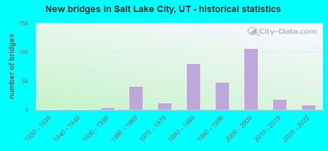
- New bridges - historical statistics
- 11930-1939
- 11940-1949
- 41950-1959
- 411960-1969
- 121970-1979
- 801980-1989
- 481990-1999
- 1062000-2009
- 182010-2019
- 92020-2022
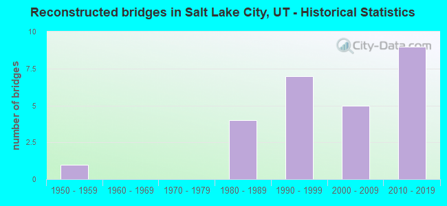
- Reconstructed bridges - Historical Statistics
- 11950-1959
- 01960-1969
- 01970-1979
- 41980-1989
- 71990-1999
- 52000-2009
- 92010-2019

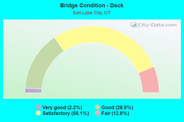
- Bridge Condition - Deck
- 2.2%Very good
- 28.9%Good
- 56.1%Satisfactory
- 12.8%Fair
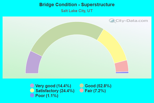
- Bridge Condition - Superstructure
- 14.4%Very good
- 52.8%Good
- 24.4%Satisfactory
- 7.2%Fair
- 1.1%Poor
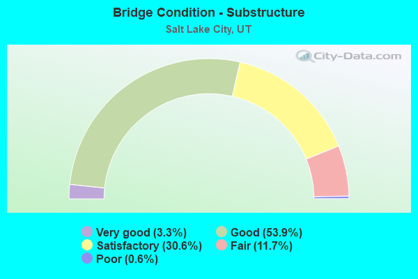
- Bridge Condition - Substructure
- 3.3%Very good
- 53.9%Good
- 30.6%Satisfactory
- 11.7%Fair
- 0.6%Poor
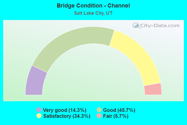
- Bridge Condition - Channel
- 14.3%Very good
- 45.7%Good
- 34.3%Satisfactory
- 5.7%Fair
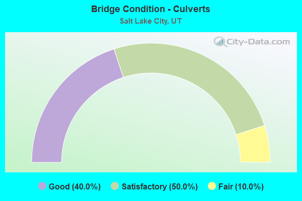
- Bridge Condition - Culverts
- 40.0%Good
- 50.0%Satisfactory
- 10.0%Fair
Find on map >> Show street view
Structure Number: 3F 632, Location: 2100 SOUTH INTERCHANGE (Lat: 40.725800, Lng: -111.905036), Route carried "on" structure: Interstate 15, Year Built: 1999, Status: Open, Structure Length: 4.63m (15.19ft), Average Daily Traffic: 23,546 (year 2020), Truck Traffic: 25%, Average Future Daily Traffic: 29,433 (year 2040), Design Load: HS 25 or greater, Features Intersected: 2100 SOUTH STREET
Minimum Vertical Clearance: 11.06m (36.29ft), Kilometerpoint: 2.383, Lanes on structure: 2, Lanes under structure: 7, Owner: State Highway Agency, Approaching Roadway Width: 11.7m (38.4ft), Material/Design: Prestressed concrete, Design/Construction: Stringer/Multi-beam, Number Of Spans In Main Unit: 1, Length of Maximum Span: 45.4m (149.0ft), Curb-To-Curb Width: 12.0m (39.4ft), Out-to-Out Width: 12.9m (42.3ft)
Condition: Deck: Good, Superstructure: Good, Substructure: Good, Operating Rating: 51.2 metric tons, Method Used To Determine Operating Rating: Load and Resistance Factor Rating (LRFR) rating reported by rating factor(RF) method using HL-93 loadings, Inventory Rating: 43.7 metric tons, Method Used To Determine Inventory Rating: Load Factor (LF) rating reported by rating factor (RF) method using MS18 loading, Structural Evaluation: Better than present minimum criteria, Deck Geometry: Equal to present minimum criteria, Underclear: Meets minimum limits, Approach Roadway Alignment: Equal to present desirable criteria, Designated Inspection Frequency: Every 26 months, Inspection Date: May 2020, Deck Structure Type: Concrete Cast-file-Place, Wearing Surface/Protective System: Deck Protection: Epoxy Coated Reinforcing
Find on map >> Show street view
Structure Number: 3F 633S, Location: 400 WEST 1700 SOUTH, SLC. (Lat: 40.733864, Lng: -111.904892), Route carried "on" structure: Interstate 15, Year Built: 1999, Status: Open, Structure Length: 4.22m (13.85ft), Average Daily Traffic: 247,095 (year 2020), Truck Traffic: 7%, Average Future Daily Traffic: 308,869 (year 2040), Design Load: HS 25 or greater, Features Intersected: 1700 SOUTH STREET
Minimum Vertical Clearance: 30+ m (98+ ft), Kilometerpoint: 492.493, Lanes on structure: 5, Lanes under structure: 4, Base Highway Network: Yes, Owner: State Highway Agency, Approaching Roadway Width: 25.1m (82.3ft), Skew: 30 degrees, Material/Design: Prestressed concrete, Design/Construction: Stringer/Multi-beam, Number Of Spans In Main Unit: 1, Length of Maximum Span: 41.3m (135.5ft), Curb-To-Curb Width: 25.1m (82.3ft), Out-to-Out Width: 25.9m (85.0ft)
Condition: Deck: Satisfactory, Superstructure: Satisfactory, Substructure: Good, Operating Rating: 52.8 metric tons, Method Used To Determine Operating Rating: Load and Resistance Factor Rating (LRFR) rating reported by rating factor(RF) method using HL-93 loadings, Inventory Rating: 45.4 metric tons, Method Used To Determine Inventory Rating: Load Factor (LF) rating reported by rating factor (RF) method using MS18 loading, Structural Evaluation: Equal to present minimum criteria, Deck Geometry: Better than present minimum criteria, Underclear: Meets minimum limits, Approach Roadway Alignment: Equal to present desirable criteria, Designated Inspection Frequency: Every 26 months, Inspection Date: May 2020, Deck Structure Type: Concrete Cast-file-Place, Wearing Surface/Protective System: Wearing Surface: Monolithic Concrete, Deck Protection: Epoxy Coated Reinforcing
Find on map >> Show street view
Structure Number: 3F 635, Location: 400 WEST 1700 SO.ST.,SLC. (Lat: 40.733858, Lng: -111.905167), Route carried "on" structure: Interstate 15, Year Built: 1999, Status: Open, Structure Length: 4.22m (13.85ft), Average Daily Traffic: 23,546 (year 2020), Truck Traffic: 25%, Average Future Daily Traffic: 29,433 (year 2040), Design Load: HS 25 or greater, Features Intersected: 1700 SOUTH STREET
Minimum Vertical Clearance: 30+ m (98+ ft), Kilometerpoint: 1.488, Lanes on structure: 4, Lanes under structure: 4, Owner: State Highway Agency, Approaching Roadway Width: 20.4m (66.9ft), Material/Design: Prestressed concrete, Design/Construction: Stringer/Multi-beam, Number Of Spans In Main Unit: 1, Length of Maximum Span: 41.3m (135.5ft), Curb-To-Curb Width: 20.4m (66.9ft), Out-to-Out Width: 21.3m (69.9ft)
Condition: Deck: Good, Superstructure: Satisfactory, Substructure: Good, Operating Rating: 51.8 metric tons, Method Used To Determine Operating Rating: Load and Resistance Factor Rating (LRFR) rating reported by rating factor(RF) method using HL-93 loadings, Inventory Rating: 43.4 metric tons, Method Used To Determine Inventory Rating: Load Factor (LF) rating reported by rating factor (RF) method using MS18 loading, Structural Evaluation: Equal to present minimum criteria, Deck Geometry: Equal to present minimum criteria, Underclear: Meets minimum limits, Approach Roadway Alignment: Equal to present desirable criteria, Designated Inspection Frequency: Every 26 months, Inspection Date: May 2020, Deck Structure Type: Concrete Cast-file-Place, Wearing Surface/Protective System: Wearing Surface: Monolithic Concrete, Deck Protection: Epoxy Coated Reinforcing
Find on map >> Show street view
Structure Number: 3F 636S, Location: APPROX.450 W.1200 SO.SLC. (Lat: 40.745586, Lng: -111.905086), Route carried "on" structure: Interstate 15, Year Built: 2000, Status: Open, Structure Length: 7.27m (23.85ft), Average Daily Traffic: 219,387 (year 2020), Truck Traffic: 7%, Average Future Daily Traffic: 274,234 (year 2040), Design Load: HS 25 or greater, Features Intersected: SR-270, SBL
Minimum Vertical Clearance: 30+ m (98+ ft), Kilometerpoint: 493.808, Lanes on structure: 5, Lanes under structure: 2, Base Highway Network: Yes, Owner: State Highway Agency, Approaching Roadway Width: 26.3m (86.3ft), Skew: 35 degrees, Material/Design: Prestressed concrete continuous, Design/Construction: Stringer/Multi-beam, Number Of Spans In Main Unit: 3, Length of Maximum Span: 31.9m (104.7ft), Curb-To-Curb Width: 26.3m (86.3ft), Out-to-Out Width: 27.1m (88.9ft)
Condition: Deck: Satisfactory, Superstructure: Good, Substructure: Good, Operating Rating: 64.2 metric tons, Method Used To Determine Operating Rating: Load and Resistance Factor Rating (LRFR) rating reported by rating factor(RF) method using HL-93 loadings, Inventory Rating: 46.3 metric tons, Method Used To Determine Inventory Rating: Load and Resistance Factor Rating (LRFR) rating reported by rating factor(RF) method using HL-93 loadings, Structural Evaluation: Better than present minimum criteria, Deck Geometry: Superior to present desirable criteria, Underclear: Somewhat better than minimum adequacy, Approach Roadway Alignment: Equal to present desirable criteria, Designated Inspection Frequency: Every 26 months, Inspection Date: May 2020, Deck Structure Type: Concrete Cast-file-Place, Wearing Surface/Protective System: Wearing Surface: Epoxy Overlay, Deck Protection: Epoxy Coated Reinforcing
Find on map >> Show street view
Structure Number: 3F 637S, Location: APPROX.450 W.1000 SO.SLC. (Lat: 40.747497, Lng: -111.907114), Route carried "on" structure: Interstate 15, Year Built: 2001, Status: Open, Structure Length: 6.49m (21.29ft), Average Daily Traffic: 219,387 (year 2020), Truck Traffic: 7%, Average Future Daily Traffic: 274,234 (year 2040), Design Load: HS 20+Mod, Features Intersected: UPRR & 500 WEST ST.
Minimum Vertical Clearance: 30+ m (98+ ft), Kilometerpoint: 494.083, Lanes on structure: 7, Lanes under structure: 2, Base Highway Network: Yes, Owner: State Highway Agency, Approaching Roadway Width: 43.7m (143.4ft), Skew: 32 degrees, Material/Design: Prestressed concrete continuous, Design/Construction: Stringer/Multi-beam, Number Of Spans In Main Unit: 3, Length of Maximum Span: 34.5m (113.2ft), Curb-To-Curb Width: 43.9m (144.0ft), Out-to-Out Width: 44.9m (147.3ft)
Condition: Deck: Satisfactory, Superstructure: Good, Substructure: Good, Operating Rating: 76.8 metric tons, Method Used To Determine Operating Rating: Load and Resistance Factor Rating (LRFR) rating reported by rating factor(RF) method using HL-93 loadings, Inventory Rating: 45.7 metric tons, Method Used To Determine Inventory Rating: Load Factor (LF) rating reported by rating factor (RF) method using MS18 loading, Structural Evaluation: Better than present minimum criteria, Deck Geometry: Superior to present desirable criteria, Underclear: Somewhat better than minimum adequacy, Approach Roadway Alignment: Equal to present desirable criteria, Designated Inspection Frequency: Every 26 months, Inspection Date: May 2020, Deck Structure Type: Concrete Cast-file-Place, Wearing Surface/Protective System: Wearing Surface: Epoxy Overlay, Deck Protection: Epoxy Coated Reinforcing
Find on map >> Show street view
Structure Number: 3F 655S, Location: 450 WEST 1300 SO.ST.,SLC. (Lat: 40.741978, Lng: -111.904314), Route carried "on" structure: Interstate 15, Year Built: 2001, Status: Open, Structure Length: 5.66m (18.57ft), Average Daily Traffic: 247,095 (year 2020), Truck Traffic: 7%, Average Future Daily Traffic: 308,869 (year 2040), Design Load: HS 25 or greater, Features Intersected: 1300 SOUTH STREET
Minimum Vertical Clearance: 5.22m (17.13ft), Kilometerpoint: 493.395, Lanes on structure: 5, Lanes under structure: 8, Base Highway Network: Yes, Owner: State Highway Agency, Approaching Roadway Width: 25.1m (82.3ft), Skew: 30 degrees, Material/Design: Prestressed concrete continuous, Design/Construction: Stringer/Multi-beam, Number Of Spans In Main Unit: 3, Length of Maximum Span: 34.3m (112.5ft), Curb-To-Curb Width: 25.1m (82.3ft), Out-to-Out Width: 25.9m (85.0ft)
Condition: Deck: Satisfactory, Superstructure: Good, Substructure: Good, Operating Rating: 53.1 metric tons, Method Used To Determine Operating Rating: Load and Resistance Factor Rating (LRFR) rating reported by rating factor(RF) method using HL-93 loadings, Inventory Rating: 45.0 metric tons, Method Used To Determine Inventory Rating: Load Factor (LF) rating reported by rating factor (RF) method using MS18 loading, Structural Evaluation: Better than present minimum criteria, Deck Geometry: Better than present minimum criteria, Underclear: Meets minimum limits, Approach Roadway Alignment: Equal to present desirable criteria, Designated Inspection Frequency: Every 25 months, Inspection Date: June 2020, Deck Structure Type: Concrete Cast-file-Place, Wearing Surface/Protective System: Wearing Surface: Latex Concrete, Deck Protection: Epoxy Coated Reinforcing
Find on map >> Show street view
Structure Number: 3F 657, Location: 500 WEST 1300 SO.ST.,SLC. (Lat: 40.741978, Lng: -111.904639), Route carried "on" structure: Interstate 15, Year Built: 2001, Status: Open, Structure Length: 5.58m (18.31ft), Average Daily Traffic: 23,546 (year 2020), Truck Traffic: 25%, Average Future Daily Traffic: 29,433 (year 2040), Design Load: HS 25 or greater, Features Intersected: 1300 SOUTH STREET
Minimum Vertical Clearance: 30+ m (98+ ft), Kilometerpoint: 0.585, Lanes on structure: 4, Lanes under structure: 8, Owner: State Highway Agency, Approaching Roadway Width: 20.2m (66.3ft), Material/Design: Prestressed concrete continuous, Design/Construction: Stringer/Multi-beam, Number Of Spans In Main Unit: 3, Length of Maximum Span: 34.2m (112.2ft), Curb-To-Curb Width: 20.4m (66.9ft), Out-to-Out Width: 21.3m (69.9ft)
Condition: Deck: Satisfactory, Superstructure: Good, Substructure: Satisfactory, Operating Rating: 82.9 metric tons, Method Used To Determine Operating Rating: Load and Resistance Factor Rating (LRFR) rating reported by rating factor(RF) method using HL-93 loadings, Inventory Rating: 56.7 metric tons, Method Used To Determine Inventory Rating: Load Factor (LF) rating reported by rating factor (RF) method using MS18 loading, Structural Evaluation: Equal to present minimum criteria, Deck Geometry: Equal to present minimum criteria, Underclear: Meets minimum limits, Approach Roadway Alignment: Equal to present desirable criteria, Designated Inspection Frequency: Every 25 months, Inspection Date: June 2020, Deck Structure Type: Concrete Cast-file-Place, Wearing Surface/Protective System: Wearing Surface: Latex Concrete, Deck Protection: Epoxy Coated Reinforcing
Find on map >> Show street view
Structure Number: 3F 658S, Location: 550 WEST 800 SO.ST.,SLC. (Lat: 40.752314, Lng: -111.911019), Route carried "on" structure: Interstate 15, Year Built: 2001, Status: Open, Structure Length: 5.10m (16.73ft), Average Daily Traffic: 219,387 (year 2020), Truck Traffic: 7%, Average Future Daily Traffic: 274,234 (year 2040), Design Load: HS 25 or greater, Features Intersected: 800 SOUTH STREET
Minimum Vertical Clearance: 30+ m (98+ ft), Kilometerpoint: 494.727, Lanes on structure: 7, Lanes under structure: 5, Base Highway Network: Yes, Owner: State Highway Agency, Approaching Roadway Width: 33.9m (111.2ft), Skew: 31 degrees, Material/Design: Prestressed concrete continuous, Design/Construction: Stringer/Multi-beam, Number Of Spans In Main Unit: 3, Length of Maximum Span: 30.8m (101.0ft), Curb-To-Curb Width: 33.9m (111.2ft), Out-to-Out Width: 34.7m (113.8ft)
Condition: Deck: Good, Superstructure: Very good, Substructure: Good, Operating Rating: 57.0 metric tons, Method Used To Determine Operating Rating: Load and Resistance Factor Rating (LRFR) rating reported by rating factor(RF) method using HL-93 loadings, Inventory Rating: 29.2 metric tons, Method Used To Determine Inventory Rating: Load Factor (LF) rating reported by rating factor (RF) method using MS18 loading, Structural Evaluation: Better than present minimum criteria, Deck Geometry: Superior to present desirable criteria, Underclear: Meets minimum limits, Approach Roadway Alignment: Equal to present desirable criteria, Designated Inspection Frequency: Every 25 months, Inspection Date: June 2020, Deck Structure Type: Concrete Precast Panels, Wearing Surface/Protective System: Wearing Surface: Latex Concrete, Deck Protection: Epoxy Coated Reinforcing
Find on map >> Show street view
Structure Number: 3F 660S, Location: 700 WEST 200 SO. ST.SLC (Lat: 40.765336, Lng: -111.913675), Route carried "on" structure: Interstate 15, Year Built: 2001, Status: Open, Structure Length: 4.89m (16.04ft), Average Daily Traffic: 23,546 (year 2020), Truck Traffic: 25%, Average Future Daily Traffic: 29,433 (year 2040), Design Load: HS 25 or greater, Features Intersected: 200 SOUTH STREET
Minimum Vertical Clearance: 30+ m (98+ ft), Kilometerpoint: 0.014, Lanes on structure: 5, Lanes under structure: 4, Base Highway Network: Yes (Inventory Route: 15NR3, Subroute: 3), Owner: State Highway Agency, Approaching Roadway Width: 25.0m (82.0ft), Skew: 1 degrees, Material/Design: Prestressed concrete continuous, Design/Construction: Stringer/Multi-beam, Number Of Spans In Main Unit: 3, Length of Maximum Span: 30.0m (98.4ft), Curb-To-Curb Width: 27.2m (89.2ft), Out-to-Out Width: 28.1m (92.2ft)
Condition: Deck: Good, Superstructure: Satisfactory, Substructure: Good, Operating Rating: 77.1 metric tons, Method Used To Determine Operating Rating: Load and Resistance Factor Rating (LRFR) rating reported by rating factor(RF) method using HL-93 loadings, Inventory Rating: 36.0 metric tons, Method Used To Determine Inventory Rating: Load Factor (LF) rating reported by rating factor (RF) method using MS18 loading, Structural Evaluation: Equal to present minimum criteria, Deck Geometry: Superior to present desirable criteria, Underclear: Meets minimum limits, Approach Roadway Alignment: Equal to present desirable criteria, Designated Inspection Frequency: Every 26 months, Inspection Date: May 2020, Deck Structure Type: Concrete Cast-file-Place, Wearing Surface/Protective System: Wearing Surface: Epoxy Overlay, Deck Protection: Epoxy Coated Reinforcing
Find on map >> Show street view
Structure Number: 3F 661S, Location: 700 WEST NO.TEMPLE ST.SLC (Lat: 40.771981, Lng: -111.910925), Route carried "on" structure: Interstate 15, Year Built: 2001, Status: Open, Structure Length: 7.62m (25.00ft), Average Daily Traffic: 138,982 (year 2020), Truck Traffic: 9%, Average Future Daily Traffic: 173,728 (year 2040), Design Load: HS 25 or greater, Features Intersected: NO.TEMPLE ST.&UTA TR
Minimum Vertical Clearance: 30+ m (98+ ft), Kilometerpoint: 497.013, Lanes on structure: 5, Lanes under structure: 6, Base Highway Network: Yes, Owner: State Highway Agency, Approaching Roadway Width: 24.4m (80.1ft), Skew: 31 degrees, Material/Design: Prestressed concrete continuous, Design/Construction: Stringer/Multi-beam, Number Of Spans In Main Unit: 3, Length of Maximum Span: 48.3m (158.5ft), Curb-To-Curb Width: 24.6m (80.7ft), Out-to-Out Width: 26.0m (85.3ft)
Condition: Deck: Good, Superstructure: Very good, Substructure: Good, Operating Rating: 54.8 metric tons, Method Used To Determine Operating Rating: Load and Resistance Factor Rating (LRFR) rating reported by rating factor(RF) method using HL-93 loadings, Inventory Rating: 47.3 metric tons, Method Used To Determine Inventory Rating: Load Factor (LF) rating reported by rating factor (RF) method using MS18 loading, Structural Evaluation: Better than present minimum criteria, Deck Geometry: Better than present minimum criteria, Underclear: Meets minimum limits, Approach Roadway Alignment: Equal to present desirable criteria, Designated Inspection Frequency: Every 26 months, Inspection Date: May 2020, Deck Structure Type: Concrete Cast-file-Place, Wearing Surface/Protective System: Wearing Surface: Epoxy Overlay, Deck Protection: Epoxy Coated Reinforcing
Find on map >> Show street view
Structure Number: 3F 662S, Location: 600 WEST 300 NORTH,SLC. (Lat: 40.776186, Lng: -111.910736), Route carried "on" structure: Interstate 15, Year Built: 2001, Status: Open, Structure Length: 3.93m (12.89ft), Average Daily Traffic: 138,982 (year 2020), Truck Traffic: 9%, Average Future Daily Traffic: 173,728 (year 2040), Design Load: HS 25 or greater, Features Intersected: 300 NORTH STREET
Minimum Vertical Clearance: 30+ m (98+ ft), Kilometerpoint: 497.480, Lanes on structure: 5, Lanes under structure: 2, Base Highway Network: Yes, Owner: State Highway Agency, Approaching Roadway Width: 25.2m (82.7ft), Material/Design: Prestressed concrete continuous, Design/Construction: Stringer/Multi-beam, Number Of Spans In Main Unit: 3, Length of Maximum Span: 24.0m (78.7ft), Curb-To-Curb Width: 25.2m (82.7ft), Out-to-Out Width: 26.0m (85.3ft)
Condition: Deck: Satisfactory, Superstructure: Satisfactory, Substructure: Good, Operating Rating: 56.4 metric tons, Method Used To Determine Operating Rating: Load and Resistance Factor Rating (LRFR) rating reported by rating factor(RF) method using HL-93 loadings, Inventory Rating: 24.6 metric tons, Method Used To Determine Inventory Rating: Load Factor (LF) rating reported by rating factor (RF) method using MS18 loading, Structural Evaluation: Equal to present minimum criteria, Deck Geometry: Better than present minimum criteria, Underclear: Meets minimum limits, Approach Roadway Alignment: Equal to present desirable criteria, Designated Inspection Frequency: Every 26 months, Inspection Date: May 2020, Deck Structure Type: Concrete Cast-file-Place, Wearing Surface/Protective System: Wearing Surface: Epoxy Overlay, Deck Protection: Epoxy Coated Reinforcing
Find on map >> Show street view
Structure Number: 3F 666, Location: 2100 SOUTH INTERCHANGE (Lat: 40.725797, Lng: -111.905217), Route carried "on" structure: Ramp Interstate 15, Year Built: 1999, Status: Open, Structure Length: 4.49m (14.73ft), Average Daily Traffic: 23,546 (year 2020), Truck Traffic: 25%, Average Future Daily Traffic: 29,433 (year 2040), Design Load: HS 25 or greater, Features Intersected: 2100 SOUTH STREET
Minimum Vertical Clearance: 10.96m (35.96ft), Kilometerpoint: 0.357, Lanes on structure: 1, Lanes under structure: 6, Owner: State Highway Agency, Approaching Roadway Width: 8.7m (28.5ft), Material/Design: Prestressed concrete, Design/Construction: Stringer/Multi-beam, Number Of Spans In Main Unit: 1, Length of Maximum Span: 44.0m (144.4ft), Curb-To-Curb Width: 9.0m (29.5ft), Out-to-Out Width: 9.9m (32.5ft)
Condition: Deck: Good, Superstructure: Satisfactory, Substructure: Good, Operating Rating: 49.6 metric tons, Method Used To Determine Operating Rating: Load and Resistance Factor Rating (LRFR) rating reported by rating factor(RF) method using HL-93 loadings, Inventory Rating: 47.0 metric tons, Method Used To Determine Inventory Rating: Load Factor (LF) rating reported by rating factor (RF) method using MS18 loading, Structural Evaluation: Equal to present minimum criteria, Deck Geometry: Superior to present desirable criteria, Underclear: Meets minimum limits, Approach Roadway Alignment: Equal to present desirable criteria, Designated Inspection Frequency: Every 26 months, Inspection Date: May 2020, Deck Structure Type: Concrete Cast-file-Place, Wearing Surface/Protective System: Wearing Surface: Monolithic Concrete, Deck Protection: Epoxy Coated Reinforcing
Find on map >> Show street view
Structure Number: 3F 774, Location: 2300 No.Becks St. in SLC (Lat: 40.817333, Lng: -111.918858), Route carried "on" structure: Interstate 15, Year Built: 2010, Status: Open, Structure Length: 18.73m (61.45ft), Average Daily Traffic: 117,063 (year 2020), Truck Traffic: 11%, Average Future Daily Traffic: 146,329 (year 2040), Design Load: HL 93, Features Intersected: US-89SB,UPRR & UTA
Minimum Vertical Clearance: 30+ m (98+ ft), Kilometerpoint: 502.413, Lanes on structure: 4, Lanes under structure: 4, Base Highway Network: Yes, Owner: State Highway Agency, Approaching Roadway Width: 21.3m (69.9ft), Skew: 4 degrees, Material/Design: Prestressed concrete continuous, Design/Construction: Stringer/Multi-beam, Number Of Spans In Main Unit: 4, Length of Maximum Span: 59.9m (196.5ft), Curb-To-Curb Width: 21.3m (69.9ft), Out-to-Out Width: 22.8m (74.8ft)
Condition: Deck: Good, Superstructure: Very good, Substructure: Good, Operating Rating: 33.7 metric tons, Method Used To Determine Operating Rating: Load and Resistance Factor Rating (LRFR) rating reported by rating factor(RF) method using HL-93 loadings, Inventory Rating: 24.6 metric tons, Method Used To Determine Inventory Rating: Load and Resistance Factor Rating (LRFR) rating reported by rating factor(RF) method using HL-93 loadings, Structural Evaluation: Equal to present minimum criteria, Deck Geometry: Better than present minimum criteria, Underclear: High priority of corrective action, Approach Roadway Alignment: Equal to present desirable criteria, Designated Inspection Frequency: Every 26 months, Inspection Date: May 2020, Deck Structure Type: Concrete Cast-file-Place, Wearing Surface/Protective System: Wearing Surface: Epoxy Overlay, Deck Protection: Epoxy Coated Reinforcing
Find on map >> Show street view
Structure Number: 4C 4, Location: 1000 SO.400 WEST,SLC (Lat: 40.747153, Lng: -111.903158), Route carried "on" structure: State highway 15, Year Built: 1967, Year Reconstructed: 2001, Status: Open, Structure Length: 4.86m (15.94ft), Average Daily Traffic: 23,546 (year 2020), Truck Traffic: 25%, Average Future Daily Traffic: 29,433 (year 2040), Design Load: HS 20+Mod, Features Intersected: 400 WEST STREET
Minimum Vertical Clearance: 30.18m (99.02ft), Kilometerpoint: 0.985, Lanes on structure: 2, Lanes under structure: 2, Owner: State Highway Agency, Approaching Roadway Width: 9.5m (31.2ft), Skew: 11 degrees, Material/Design: Steel, Design/Construction: Stringer/Multi-beam, Number Of Spans In Main Unit: 3, Length of Maximum Span: 18.8m (61.7ft), Curb-To-Curb Width: 9.5m (31.2ft), Out-to-Out Width: 10.4m (34.1ft)
Condition: Deck: Satisfactory, Superstructure: Good, Substructure: Fair, Operating Rating: 35.3 metric tons, Method Used To Determine Operating Rating: Load Factor (LF) rating reported by rating factor (RF) method using MS18 loading, Inventory Rating: 22.4 metric tons, Method Used To Determine Inventory Rating: Load Factor (LF) rating reported by rating factor (RF) method using MS18 loading, Structural Evaluation: Somewhat better than minimum adequacy, Deck Geometry: High priority of replacement, Underclear: Superior to present desirable criteria, Approach Roadway Alignment: Equal to present minimum criteria, Designated Inspection Frequency: Every 26 months, Inspection Date: May 2020, Deck Structure Type: Concrete Cast-file-Place, Wearing Surface/Protective System: Wearing Surface: Bituminous, Membrane: Built-up, Deck Protection: Epoxy Coated Reinforcing
Find on map >> Show street view
Structure Number: 4C 402, Location: 980 SO.200 WEST, SLC. (Lat: 40.747597, Lng: -111.896417), Route carried "on" structure: State highway 15, Year Built: 1967, Year Reconstructed: 2018, Status: Open, Structure Length: 5.53m (18.14ft), Average Daily Traffic: 23,546 (year 2020), Truck Traffic: 25%, Average Future Daily Traffic: 29,433 (year 2040), Design Load: HS 20+Mod, Features Intersected: 200 W.ST.& UTA. TRAC
Minimum Vertical Clearance: 30+ m (98+ ft), Kilometerpoint: 0.331, Lanes on structure: 2, Lanes under structure: 2, Owner: State Highway Agency, Approaching Roadway Width: 9.8m (32.2ft), Skew: 10 degrees, Material/Design: Steel, Design/Construction: Stringer/Multi-beam, Number Of Spans In Main Unit: 3, Length of Maximum Span: 21.6m (70.9ft), Curb-To-Curb Width: 8.5m (27.9ft), Out-to-Out Width: 10.1m (33.1ft)
Condition: Deck: Satisfactory, Superstructure: Good, Substructure: Good, Operating Rating: 48.6 metric tons, Method Used To Determine Operating Rating: Load and Resistance Factor Rating (LRFR) rating reported by rating factor(RF) method using HL-93 loadings, Inventory Rating: 36.6 metric tons, Method Used To Determine Inventory Rating: Load Factor (LF) rating reported by rating factor (RF) method using MS18 loading, Structural Evaluation: Better than present minimum criteria, Deck Geometry: High priority of replacement, Underclear: Superior to present desirable criteria, Approach Roadway Alignment: Equal to present desirable criteria, Designated Inspection Frequency: Every 26 months, Inspection Date: June 2020, Deck Structure Type: Concrete Cast-file-Place, Wearing Surface/Protective System: Wearing Surface: Bituminous, Membrane: Preformed Fabric, Deck Protection: Epoxy Coated Reinforcing
Find on map >> Show street view
Structure Number: 4C 71, Location: 0.6 MI.W.OF 5600 W.INTCHG (Lat: 40.771189, Lng: -112.038819), Route carried "on" structure: Interstate 80, Year Built: 1981, Status: Open, Structure Length: 4.75m (15.58ft), Average Daily Traffic: 23,579 (year 2020), Truck Traffic: 22%, Average Future Daily Traffic: 29,474 (year 2040), Design Load: HS 20+Mod, Features Intersected: SL&GW RAILWAY
Minimum Vertical Clearance: 30+ m (98+ ft), Kilometerpoint: 181.481, Lanes on structure: 2, Base Highway Network: Yes, Owner: State Highway Agency, Approaching Roadway Width: 11.6m (38.1ft), Material/Design: Steel continuous, Design/Construction: Stringer/Multi-beam, Number Of Spans In Main Unit: 3, Length of Maximum Span: 31.7m (104.0ft), Curb-To-Curb Width: 12.4m (40.7ft), Out-to-Out Width: 13.5m (44.3ft)
Condition: Deck: Fair, Superstructure: Good, Substructure: Good, Operating Rating: 40.2 metric tons, Method Used To Determine Operating Rating: Load and Resistance Factor Rating (LRFR) rating reported by rating factor(RF) method using HL-93 loadings, Inventory Rating: 32.4 metric tons, Method Used To Determine Inventory Rating: Load Factor (LF) rating reported by rating factor (RF) method using MS18 loading, Structural Evaluation: Better than present minimum criteria, Deck Geometry: Better than present minimum criteria, Underclear: Better than present minimum criteria, Approach Roadway Alignment: Equal to present desirable criteria, Designated Inspection Frequency: Every 24 months, Inspection Date: November 2020, Deck Structure Type: Concrete Cast-file-Place, Wearing Surface/Protective System: Deck Protection: Epoxy Coated Reinforcing
Find on map >> Show street view
Structure Number: 4C 873, Location: 5TH SOUTH VIADUCT in SLC. (Lat: 40.757922, Lng: -111.910178), Route carried "on" structure: Ramp State highway 15, Year Built: 2000, Status: Open, Structure Length: 41.51m (136.19ft), Average Daily Traffic: 23,546 (year 2020), Truck Traffic: 25%, Average Future Daily Traffic: 29,433 (year 2040), Design Load: HS 25 or greater, Features Intersected: I-15 (SR-15) & UPRR, Facility Carried by Structure: SR-269,SB.ON-RAMP
Minimum Vertical Clearance: 5.28m (17.32ft), Kilometerpoint: 0.414, Lanes on structure: 2, Lanes under structure: 13, Owner: State Highway Agency, Approaching Roadway Width: 12.0m (39.4ft), Material/Design: Steel continuous, Design/Construction: Stringer/Multi-beam, Number Of Spans In Main Unit: 7, Length of Maximum Span: 81.5m (267.4ft), Curb-To-Curb Width: 12.0m (39.4ft), Out-to-Out Width: 12.9m (42.3ft)
Condition: Deck: Satisfactory, Superstructure: Good, Substructure: Satisfactory, Operating Rating: 59.9 metric tons, Method Used To Determine Operating Rating: Load and Resistance Factor Rating (LRFR) rating reported by rating factor(RF) method using HL-93 loadings, Inventory Rating: 20.4 metric tons, Method Used To Determine Inventory Rating: Load and Resistance Factor Rating (LRFR) rating reported by rating factor(RF) method using HL-93 loadings, Structural Evaluation: Somewhat better than minimum adequacy, Deck Geometry: Superior to present desirable criteria, Underclear: Equal to present minimum criteria, Approach Roadway Alignment: Equal to present desirable criteria, Designated Inspection Frequency: Every 26 months, Inspection Date: June 2020, Deck Structure Type: Concrete Cast-file-Place, Wearing Surface/Protective System: Wearing Surface: Epoxy Overlay, Deck Protection: Epoxy Coated Reinforcing
Find on map >> Show street view
Structure Number: 4C 874, Location: 500 SOUTH VIADUCT in SLC (Lat: 40.758028, Lng: -111.910217), Route carried "on" structure: Ramp Interstate 15, Year Built: 2000, Status: Open, Structure Length: 13.96m (45.80ft), Average Daily Traffic: 23,546 (year 2020), Truck Traffic: 25%, Average Future Daily Traffic: 29,433 (year 2040), Design Load: HS 25 or greater, Features Intersected: UPRR & 700 W
Minimum Vertical Clearance: 30.18m (99.02ft), Kilometerpoint: 0.030, Lanes on structure: 2, Owner: State Highway Agency, Approaching Roadway Width: 12.0m (39.4ft), Material/Design: Steel continuous, Design/Construction: Stringer/Multi-beam, Number Of Spans In Main Unit: 3, Length of Maximum Span: 54.0m (177.2ft), Curb-To-Curb Width: 12.0m (39.4ft), Out-to-Out Width: 12.9m (42.3ft)
Condition: Deck: Satisfactory, Superstructure: Good, Substructure: Satisfactory, Operating Rating: 60.6 metric tons, Method Used To Determine Operating Rating: Load and Resistance Factor Rating (LRFR) rating reported by rating factor(RF) method using HL-93 loadings, Inventory Rating: 49.9 metric tons, Method Used To Determine Inventory Rating: Load and Resistance Factor Rating (LRFR) rating reported by rating factor(RF) method using HL-93 loadings, Structural Evaluation: Equal to present minimum criteria, Deck Geometry: Superior to present desirable criteria, Underclear: Better than present minimum criteria, Approach Roadway Alignment: Equal to present desirable criteria, Designated Inspection Frequency: Every 26 months, Inspection Date: June 2020, Deck Structure Type: Concrete Cast-file-Place, Wearing Surface/Protective System: Wearing Surface: Epoxy Overlay, Deck Protection: Epoxy Coated Reinforcing
Find on map >> Show street view
Structure Number: 4C 883, Location: 225 SOUTH 1000 WEST, SLC. (Lat: 40.764642, Lng: -111.919314), Route carried "on" structure: Interstate 80, Year Built: 2000, Status: Open, Structure Length: 4.09m (13.42ft), Average Daily Traffic: 56,191 (year 2020), Truck Traffic: 15%, Average Future Daily Traffic: 70,239 (year 2040), Design Load: HS 25 or greater, Features Intersected: 1000 WEST STREET
Minimum Vertical Clearance: 30+ m (98+ ft), Kilometerpoint: 191.729, Lanes on structure: 4, Lanes under structure: 4, Base Highway Network: Yes, Owner: State Highway Agency, Approaching Roadway Width: 20.2m (66.3ft), Material/Design: Steel, Design/Construction: Stringer/Multi-beam, Number Of Spans In Main Unit: 1, Length of Maximum Span: 40.0m (131.2ft), Curb-To-Curb Width: 20.4m (66.9ft), Out-to-Out Width: 21.0m (68.9ft)
Condition: Deck: Satisfactory, Superstructure: Good, Substructure: Good, Operating Rating: 97.2 metric tons, Method Used To Determine Operating Rating: Load and Resistance Factor Rating (LRFR) rating reported by rating factor(RF) method using HL-93 loadings, Inventory Rating: 87.2 metric tons, Method Used To Determine Inventory Rating: Load Factor (LF) rating reported by rating factor (RF) method using MS18 loading, Structural Evaluation: Better than present minimum criteria, Deck Geometry: Equal to present minimum criteria, Underclear: Somewhat better than minimum adequacy, Approach Roadway Alignment: Equal to present desirable criteria, Designated Inspection Frequency: Every 24 months, Inspection Date: December 2020, Deck Structure Type: Concrete Cast-file-Place, Wearing Surface/Protective System: Wearing Surface: Epoxy Overlay, Deck Protection: Epoxy Coated Reinforcing
Find on map >> Show street view
Structure Number: 4C 885, Location: 220 SOUTH 900 WEST, SLC (Lat: 40.764583, Lng: -111.916439), Route carried "on" structure: Interstate 80, Year Built: 2000, Status: Open, Structure Length: 4.09m (13.42ft), Average Daily Traffic: 56,191 (year 2020), Truck Traffic: 15%, Average Future Daily Traffic: 70,239 (year 2040), Design Load: HS 25 or greater, Features Intersected: 900 WEST STREET
Minimum Vertical Clearance: 30+ m (98+ ft), Kilometerpoint: 191.972, Lanes on structure: 3, Lanes under structure: 4, Base Highway Network: Yes, Owner: State Highway Agency, Approaching Roadway Width: 16.8m (55.1ft), Material/Design: Steel, Design/Construction: Stringer/Multi-beam, Number Of Spans In Main Unit: 1, Length of Maximum Span: 40.0m (131.2ft), Curb-To-Curb Width: 16.8m (55.1ft), Out-to-Out Width: 17.7m (58.1ft)
Condition: Deck: Satisfactory, Superstructure: Good, Substructure: Satisfactory, Operating Rating: 72.6 metric tons, Method Used To Determine Operating Rating: Load and Resistance Factor Rating (LRFR) rating reported by rating factor(RF) method using HL-93 loadings, Inventory Rating: 49.6 metric tons, Method Used To Determine Inventory Rating: Load Factor (LF) rating reported by rating factor (RF) method using MS18 loading, Structural Evaluation: Equal to present minimum criteria, Deck Geometry: Equal to present minimum criteria, Underclear: Somewhat better than minimum adequacy, Approach Roadway Alignment: Equal to present desirable criteria, Designated Inspection Frequency: Every 25 months, Inspection Date: June 2020, Deck Structure Type: Concrete Cast-file-Place, Wearing Surface/Protective System: Wearing Surface: Epoxy Overlay, Deck Protection: Epoxy Coated Reinforcing
Find on map >> Show street view
Structure Number: 4C 917, Location: AIRPORT INTCHG., SLC (Lat: 40.765411, Lng: -111.979850), Route carried "on" structure: Ramp Interstate 80, Year Built: 2001, Status: Open, Structure Length: 10.40m (34.12ft), Average Daily Traffic: 7,905 (year 2020), Truck Traffic: 58%, Average Future Daily Traffic: 9,881 (year 2040), Design Load: HS 20+Mod, Features Intersected: RP.SR-186WB to I-80WB
Minimum Vertical Clearance: 30+ m (98+ ft), Kilometerpoint: 0.675, Lanes on structure: 1, Lanes under structure: 1, Owner: State Highway Agency, Approaching Roadway Width: 8.5m (27.9ft), Skew: 5 degrees, Material/Design: Steel continuous, Design/Construction: Stringer/Multi-beam, Number Of Spans In Main Unit: 3, Length of Maximum Span: 49.0m (160.8ft), Curb-To-Curb Width: 8.5m (27.9ft), Out-to-Out Width: 9.5m (31.2ft)
Condition: Deck: Good, Superstructure: Very good, Substructure: Very good, Operating Rating: 97.2 metric tons, Method Used To Determine Operating Rating: Load and Resistance Factor Rating (LRFR) rating reported by rating factor(RF) method using HL-93 loadings, Inventory Rating: 85.5 metric tons, Method Used To Determine Inventory Rating: Load and Resistance Factor Rating (LRFR) rating reported by rating factor(RF) method using HL-93 loadings, Structural Evaluation: Equal to present desirable criteria, Deck Geometry: Superior to present desirable criteria, Underclear: Equal to present desirable criteria, Approach Roadway Alignment: Equal to present desirable criteria, Designated Inspection Frequency: Every 24 months, Inspection Date: December 2020, Deck Structure Type: Concrete Cast-file-Place, Wearing Surface/Protective System: Wearing Surface: Monolithic Concrete, Deck Protection: Epoxy Coated Reinforcing
Find on map >> Show street view
Structure Number: 4C 937, Location: MP 15.90 (Lat: 40.724708, Lng: -111.938581), Route carried "on" structure: Ramp US 201, Year Built: 2006, Status: Open, Structure Length: 5.42m (17.78ft), Average Daily Traffic: 15,981 (year 2020), Truck Traffic: 19%, Average Future Daily Traffic: 19,976 (year 2040), Design Load: HL 93, Features Intersected: SR-68, REDWOOD ROAD
Minimum Vertical Clearance: 30+ m (98+ ft), Kilometerpoint: 0.577, Lanes on structure: 2, Lanes under structure: 6, Owner: State Highway Agency, Approaching Roadway Width: 11.0m (36.1ft), Material/Design: Steel, Design/Construction: Stringer/Multi-beam, Number Of Spans In Main Unit: 1, Length of Maximum Span: 53.1m (174.2ft), Curb-To-Curb Width: 11.0m (36.1ft), Out-to-Out Width: 13.1m (43.0ft)
Condition: Deck: Satisfactory, Superstructure: Very good, Substructure: Good, Operating Rating: 55.7 metric tons, Method Used To Determine Operating Rating: Load and Resistance Factor Rating (LRFR) rating reported by rating factor(RF) method using HL-93 loadings, Inventory Rating: 37.6 metric tons, Method Used To Determine Inventory Rating: Load and Resistance Factor Rating (LRFR) rating reported by rating factor(RF) method using HL-93 loadings, Structural Evaluation: Better than present minimum criteria, Deck Geometry: Better than present minimum criteria, Underclear: High priority of corrective action, Approach Roadway Alignment: Equal to present desirable criteria, Designated Inspection Frequency: Every 24 months, Inspection Date: December 2020, Deck Structure Type: Concrete Cast-file-Place, Wearing Surface/Protective System: Wearing Surface: Epoxy Overlay, Deck Protection: Epoxy Coated Reinforcing
Find on map >> Show street view
Structure Number: 4C 957, Location: 2400 South 500 East, SLC (Lat: 40.718369, Lng: -111.876511), Route carried "on" structure: Interstate 80, Year Built: 2008, Status: Open, Structure Length: 3.41m (11.19ft), Average Daily Traffic: 117,829 (year 2020), Truck Traffic: 15%, Average Future Daily Traffic: 147,286 (year 2040), Design Load: HL 93, Features Intersected: 500 EAST STREET in SLC
Minimum Vertical Clearance: 30+ m (98+ ft), Kilometerpoint: 199.709, Lanes on structure: 5, Lanes under structure: 2, Base Highway Network: Yes, Owner: State Highway Agency, Approaching Roadway Width: 24.4m (80.1ft), Skew: 30 degrees, Material/Design: Steel, Design/Construction: Stringer/Multi-beam, Number Of Spans In Main Unit: 1, Length of Maximum Span: 32.9m (107.9ft), Curb-To-Curb Width: 25.6m (84.0ft), Out-to-Out Width: 26.5m (86.9ft)
Condition: Deck: Satisfactory, Superstructure: Good, Substructure: Good, Operating Rating: 79.4 metric tons, Method Used To Determine Operating Rating: Load and Resistance Factor Rating (LRFR) rating reported by rating factor(RF) method using HL-93 loadings, Inventory Rating: 61.2 metric tons, Method Used To Determine Inventory Rating: Load and Resistance Factor Rating (LRFR) rating reported by rating factor(RF) method using HL-93 loadings, Structural Evaluation: Better than present minimum criteria, Deck Geometry: Better than present minimum criteria, Underclear: Equal to present minimum criteria, Approach Roadway Alignment: Equal to present desirable criteria, Designated Inspection Frequency: Every 25 months, Inspection Date: June 2020, Deck Structure Type: Concrete Cast-file-Place, Wearing Surface/Protective System: Wearing Surface: Epoxy Overlay, Deck Protection: Epoxy Coated Reinforcing
Find on map >> Show street view
Structure Number: 4C 958, Location: At the 700 E. Int. in SLC (Lat: 40.718911, Lng: -111.870797), Route carried "on" structure: Interstate 80, Year Built: 2008, Status: Open, Structure Length: 5.28m (17.32ft), Average Daily Traffic: 117,829 (year 2020), Truck Traffic: 15%, Average Future Daily Traffic: 147,286 (year 2040), Design Load: HL 93, Features Intersected: SR-71, 700 EAST ST.
Minimum Vertical Clearance: 30+ m (98+ ft), Kilometerpoint: 200.196, Lanes on structure: 4, Lanes under structure: 10, Base Highway Network: Yes, Owner: State Highway Agency, Approaching Roadway Width: 20.7m (67.9ft), Skew: 31 degrees, Material/Design: Steel, Design/Construction: Stringer/Multi-beam, Number Of Spans In Main Unit: 1, Length of Maximum Span: 51.5m (169.0ft), Curb-To-Curb Width: 22.0m (72.2ft), Out-to-Out Width: 22.8m (74.8ft)
Condition: Deck: Good, Superstructure: Good, Substructure: Very good, Operating Rating: 78.7 metric tons, Method Used To Determine Operating Rating: Load and Resistance Factor Rating (LRFR) rating reported by rating factor(RF) method using HL-93 loadings, Inventory Rating: 46.7 metric tons, Method Used To Determine Inventory Rating: Load and Resistance Factor Rating (LRFR) rating reported by rating factor(RF) method using HL-93 loadings, Structural Evaluation: Better than present minimum criteria, Deck Geometry: Better than present minimum criteria, Underclear: Somewhat better than minimum adequacy, Approach Roadway Alignment: Equal to present desirable criteria, Designated Inspection Frequency: Every 26 months, Inspection Date: June 2020, Deck Structure Type: Concrete Cast-file-Place, Wearing Surface/Protective System: Wearing Surface: Latex Concrete, Deck Protection: Epoxy Coated Reinforcing
Find on map >> Show street view
Structure Number: 4C 959, Location: 2400 So. 900 East , SLC (Lat: 40.719525, Lng: -111.865028), Route carried "on" structure: Interstate 80, Year Built: 2008, Status: Open, Structure Length: 3.69m (12.11ft), Average Daily Traffic: 110,237 (year 2020), Truck Traffic: 16%, Average Future Daily Traffic: 137,796 (year 2040), Design Load: HL 93, Features Intersected: 900 EAST STREET in SLC
Minimum Vertical Clearance: 30+ m (98+ ft), Kilometerpoint: 200.689, Lanes on structure: 6, Lanes under structure: 2, Base Highway Network: Yes, Owner: State Highway Agency, Approaching Roadway Width: 26.2m (86.0ft), Skew: 30 degrees, Material/Design: Steel, Design/Construction: Stringer/Multi-beam, Number Of Spans In Main Unit: 1, Length of Maximum Span: 35.7m (117.1ft), Curb-To-Curb Width: 26.5m (86.9ft), Out-to-Out Width: 28.4m (93.2ft)
Condition: Deck: Good, Superstructure: Very good, Substructure: Good, Operating Rating: 82.9 metric tons, Method Used To Determine Operating Rating: Load and Resistance Factor Rating (LRFR) rating reported by rating factor(RF) method using HL-93 loadings, Inventory Rating: 62.2 metric tons, Method Used To Determine Inventory Rating: Load and Resistance Factor Rating (LRFR) rating reported by rating factor(RF) method using HL-93 loadings, Structural Evaluation: Better than present minimum criteria, Deck Geometry: Somewhat better than minimum adequacy, Underclear: Equal to present minimum criteria, Approach Roadway Alignment: Equal to present desirable criteria, Designated Inspection Frequency: Every 26 months, Inspection Date: June 2020, Deck Structure Type: Concrete Cast-file-Place, Wearing Surface/Protective System: Wearing Surface: Latex Concrete, Deck Protection: Epoxy Coated Reinforcing
Find on map >> Show street view
Structure Number: 4C 96, Location: 2400 So. 600 East in SLC (Lat: 40.718475, Lng: -111.873683), Route carried "on" structure: Interstate 80, Year Built: 2008, Status: Open, Structure Length: 2.59m (8.50ft), Average Daily Traffic: 117,829 (year 2020), Truck Traffic: 15%, Average Future Daily Traffic: 147,286 (year 2040), Design Load: HL 93, Features Intersected: 600 EAST STREET in SLC
Minimum Vertical Clearance: 30+ m (98+ ft), Kilometerpoint: 199.948, Lanes on structure: 4, Lanes under structure: 2, Base Highway Network: Yes, Owner: State Highway Agency, Approaching Roadway Width: 20.7m (67.9ft), Skew: 30 degrees, Material/Design: Steel, Design/Construction: Stringer/Multi-beam, Number Of Spans In Main Unit: 1, Length of Maximum Span: 24.5m (80.4ft), Curb-To-Curb Width: 22.0m (72.2ft), Out-to-Out Width: 22.8m (74.8ft)
Condition: Deck: Good, Superstructure: Very good, Substructure: Good, Operating Rating: 68.0 metric tons, Method Used To Determine Operating Rating: Load and Resistance Factor Rating (LRFR) rating reported by rating factor(RF) method using HL-93 loadings, Inventory Rating: 54.1 metric tons, Method Used To Determine Inventory Rating: Load and Resistance Factor Rating (LRFR) rating reported by rating factor(RF) method using HL-93 loadings, Structural Evaluation: Better than present minimum criteria, Deck Geometry: Better than present minimum criteria, Underclear: Better than present minimum criteria, Approach Roadway Alignment: Equal to present desirable criteria, Designated Inspection Frequency: Every 25 months, Inspection Date: June 2020, Deck Structure Type: Concrete Cast-file-Place, Wearing Surface/Protective System: Wearing Surface: Epoxy Overlay, Deck Protection: Epoxy Coated Reinforcing
Find on map >> Show street view
Structure Number: 4C 961, Location: 2400 So. 600 East, SLC (Lat: 40.718647, Lng: -111.873706), Route carried "on" structure: Ramp Interstate 80, Year Built: 2008, Status: Open, Structure Length: 2.59m (8.50ft), Average Daily Traffic: 7,905 (year 2020), Truck Traffic: 58%, Average Future Daily Traffic: 9,881 (year 2040), Design Load: HL 93, Features Intersected: 600 EAST STREET in SLC
Minimum Vertical Clearance: 30.18m (99.02ft), Kilometerpoint: 0.261, Lanes on structure: 2, Lanes under structure: 2, Owner: State Highway Agency, Approaching Roadway Width: 12.2m (40.0ft), Material/Design: Steel, Design/Construction: Stringer/Multi-beam, Number Of Spans In Main Unit: 1, Length of Maximum Span: 24.6m (80.7ft), Curb-To-Curb Width: 12.2m (40.0ft), Out-to-Out Width: 13.1m (43.0ft)
Condition: Deck: Good, Superstructure: Good, Substructure: Good, Operating Rating: 69.3 metric tons, Method Used To Determine Operating Rating: Load and Resistance Factor Rating (LRFR) rating reported by rating factor(RF) method using HL-93 loadings, Inventory Rating: 53.1 metric tons, Method Used To Determine Inventory Rating: Load and Resistance Factor Rating (LRFR) rating reported by rating factor(RF) method using HL-93 loadings, Structural Evaluation: Better than present minimum criteria, Deck Geometry: Superior to present desirable criteria, Underclear: Equal to present minimum criteria, Approach Roadway Alignment: Equal to present desirable criteria, Designated Inspection Frequency: Every 25 months, Inspection Date: June 2020, Deck Structure Type: Concrete Cast-file-Place, Wearing Surface/Protective System: Wearing Surface: Epoxy Overlay, Deck Protection: Epoxy Coated Reinforcing
Find on map >> Show street view
Structure Number: 4C 963, Location: 2400 South Highland Drive (Lat: 40.719767, Lng: -111.857075), Route carried "on" structure: Interstate 80, Year Built: 2008, Status: Open, Structure Length: 4.31m (14.14ft), Average Daily Traffic: 110,237 (year 2020), Truck Traffic: 16%, Average Future Daily Traffic: 137,796 (year 2040), Design Load: HL 93, Features Intersected: HIGHLAND DRIVE in SLC
Minimum Vertical Clearance: 30+ m (98+ ft), Kilometerpoint: 201.362, Lanes on structure: 5, Lanes under structure: 4, Base Highway Network: Yes, Owner: State Highway Agency, Approaching Roadway Width: 24.4m (80.1ft), Skew: 21 degrees, Material/Design: Steel, Design/Construction: Stringer/Multi-beam, Number Of Spans In Main Unit: 1, Length of Maximum Span: 41.8m (137.1ft), Curb-To-Curb Width: 25.6m (84.0ft), Out-to-Out Width: 26.5m (86.9ft)
Condition: Deck: Good, Superstructure: Very good, Substructure: Very good, Operating Rating: 72.9 metric tons, Method Used To Determine Operating Rating: Load and Resistance Factor Rating (LRFR) rating reported by rating factor(RF) method using HL-93 loadings, Inventory Rating: 50.5 metric tons, Method Used To Determine Inventory Rating: Load and Resistance Factor Rating (LRFR) rating reported by rating factor(RF) method using HL-93 loadings, Structural Evaluation: Equal to present desirable criteria, Deck Geometry: Better than present minimum criteria, Underclear: Superior to present desirable criteria, Approach Roadway Alignment: Equal to present desirable criteria, Designated Inspection Frequency: Every 26 months, Inspection Date: June 2020, Deck Structure Type: Concrete Cast-file-Place, Wearing Surface/Protective System: Wearing Surface: Epoxy Overlay, Deck Protection: Epoxy Coated Reinforcing
Find on map >> Show street view
Structure Number: 4F 36, Location: 1 MI.EAST AIRPORT INTCHG. (Lat: 40.764986, Lng: -111.965808), Route carried "on" structure: Ramp Interstate 80, Year Built: 1967, Year Reconstructed: 1986, Status: Open, Structure Length: 4.41m (14.47ft), Average Daily Traffic: 7,905 (year 2020), Truck Traffic: 58%, Average Future Daily Traffic: 9,881 (year 2040), Design Load: HS 20+Mod, Features Intersected: SURPLUS CANAL
Minimum Vertical Clearance: 30+ m (98+ ft), Kilometerpoint: 1.852, Lanes on structure: 2, Owner: State Highway Agency, Approaching Roadway Width: 11.6m (38.1ft), Skew: 13 degrees, Material/Design: Prestressed concrete, Design/Construction: Stringer/Multi-beam, Number Of Spans In Main Unit: 2, Length of Maximum Span: 22.1m (72.5ft), Curb-To-Curb Width: 11.6m (38.1ft), Out-to-Out Width: 12.5m (41.0ft)
Condition: Deck: Satisfactory, Superstructure: Fair, Substructure: Satisfactory, Channel: Good, Operating Rating: 51.5 metric tons, Method Used To Determine Operating Rating: Load Factor (LF) rating reported by rating factor (RF) method using MS18 loading, Inventory Rating: 26.9 metric tons, Method Used To Determine Inventory Rating: Load Factor (LF) rating reported by rating factor (RF) method using MS18 loading, Structural Evaluation: Somewhat better than minimum adequacy, Deck Geometry: Superior to present desirable criteria, Waterway Adequacy: Equal to present minimum criteria, Approach Roadway Alignment: Equal to present desirable criteria, Designated Inspection Frequency: Every 24 months, Inspection Date: March 2020, Deck Structure Type: Concrete Cast-file-Place, Wearing Surface/Protective System: Wearing Surface: Bituminous
Find on map >> Show street view
Structure Number: 4F 5, Location: 2400 SO. & 2000 EAST (Lat: 40.716264, Lng: -111.833058), Route carried "on" structure: Interstate 80, Year Built: 1964, Year Reconstructed: 1999, Status: Open, Structure Length: 5.32m (17.45ft), Average Daily Traffic: 90,775 (year 2020), Truck Traffic: 18%, Average Future Daily Traffic: 113,469 (year 2040), Design Load: HS 20+Mod, Features Intersected: 2000 EAST STREET
Minimum Vertical Clearance: 30+ m (98+ ft), Kilometerpoint: 203.460, Lanes on structure: 3, Lanes under structure: 4, Base Highway Network: Yes, Owner: State Highway Agency, Approaching Roadway Width: 15.9m (52.2ft), Skew: 12 degrees, Material/Design: Prestressed concrete, Design/Construction: Stringer/Multi-beam, Number Of Spans In Main Unit: 3, Length of Maximum Span: 20.3m (66.6ft), Curb-To-Curb Width: 15.9m (52.2ft), Out-to-Out Width: 16.9m (55.4ft)
Condition: Deck: Fair, Superstructure: Fair, Substructure: Satisfactory, Operating Rating: 42.1 metric tons, Method Used To Determine Operating Rating: Load and Resistance Factor Rating (LRFR) rating reported by rating factor(RF) method using HL-93 loadings, Inventory Rating: 40.8 metric tons, Method Used To Determine Inventory Rating: Load Factor (LF) rating reported by rating factor (RF) method using MS18 loading, Structural Evaluation: Somewhat better than minimum adequacy, Deck Geometry: Somewhat better than minimum adequacy, Underclear: High priority of corrective action, Approach Roadway Alignment: Equal to present desirable criteria, Designated Inspection Frequency: Every 26 months, Inspection Date: June 2020, Deck Structure Type: Concrete Cast-file-Place, Wearing Surface/Protective System: Wearing Surface: Bituminous, Membrane: Preformed Fabric
Find on map >> Show street view
Structure Number: 4F 415, Location: 1 MI.EAST AIRPORT INTCHG. (Lat: 40.764808, Lng: -111.965483), Route carried "on" structure: Ramp Interstate 80, Year Built: 1984, Status: Open, Structure Length: 3.97m (13.02ft), Average Daily Traffic: 63,914 (year 2020), Truck Traffic: 28%, Average Future Daily Traffic: 79,893 (year 2040), Design Load: HS 20+Mod, Features Intersected: SURPLUS CANAL, Facility Carried by Structure: WB.RP.to AIRPORT
Minimum Vertical Clearance: 30+ m (98+ ft), Kilometerpoint: 187.809, Lanes on structure: 2, Owner: State Highway Agency, Approaching Roadway Width: 11.0m (36.1ft), Skew: 1 degrees, Material/Design: Prestressed concrete continuous, Design/Construction: Stringer/Multi-beam, Number Of Spans In Main Unit: 2, Length of Maximum Span: 19.6m (64.3ft), Curb-To-Curb Width: 11.8m (38.7ft), Out-to-Out Width: 12.8m (42.0ft)
Condition: Deck: Fair, Superstructure: Good, Substructure: Satisfactory, Channel: Good, Operating Rating: 58.3 metric tons, Method Used To Determine Operating Rating: Load and Resistance Factor Rating (LRFR) rating reported by rating factor(RF) method using HL-93 loadings, Inventory Rating: 34.0 metric tons, Method Used To Determine Inventory Rating: Load and Resistance Factor Rating (LRFR) rating reported by rating factor(RF) method using HL-93 loadings, Structural Evaluation: Equal to present minimum criteria, Deck Geometry: Superior to present desirable criteria, Waterway Adequacy: Equal to present minimum criteria, Approach Roadway Alignment: Equal to present desirable criteria, Designated Inspection Frequency: Every 24 months, Inspection Date: March 2020, Deck Structure Type: Concrete Cast-file-Place, Wearing Surface/Protective System: Wearing Surface: Epoxy Overlay, Deck Protection: Bituminous
Find on map >> Show street view
Structure Number: 4F 641, Location: 550 to 700 W.,500 SO.SLC. (Lat: 40.758481, Lng: -111.906700), Route carried "on" structure: Ramp State highway 15, Year Built: 2000, Status: Open, Structure Length: 28.50m (93.50ft), Average Daily Traffic: 23,546 (year 2020), Truck Traffic: 25%, Average Future Daily Traffic: 29,433 (year 2040), Design Load: HS 25 or greater, Features Intersected: 600 WEST STREET & UP, Facility Carried by Structure: SR-269,WB ON-RAMP
Minimum Vertical Clearance: 30+ m (98+ ft), Kilometerpoint: 0.111, Lanes on structure: 4, Lanes under structure: 2, Base Highway Network: Yes (Inventory Route: 15NR3, Subroute: 3), Owner: State Highway Agency, Approaching Roadway Width: 19.0m (62.3ft), Material/Design: Prestressed concrete, Design/Construction: Stringer/Multi-beam, Number Of Spans In Main Unit: 3, Number Of Approach Spans: 1, Length of Maximum Span: 79.3m (260.2ft), Curb-To-Curb Width: 19.2m (63.0ft), Out-to-Out Width: 20.1m (65.9ft)
Condition: Deck: Satisfactory, Superstructure: Good, Substructure: Satisfactory, Operating Rating: 46.0 metric tons, Method Used To Determine Operating Rating: Load and Resistance Factor Rating (LRFR) rating reported by rating factor(RF) method using HL-93 loadings, Inventory Rating: 29.8 metric tons, Method Used To Determine Inventory Rating: Load and Resistance Factor Rating (LRFR) rating reported by rating factor(RF) method using HL-93 loadings, Structural Evaluation: Equal to present minimum criteria, Deck Geometry: Superior to present desirable criteria, Underclear: Meets minimum limits, Approach Roadway Alignment: Equal to present desirable criteria, Designated Inspection Frequency: Every 24 months, Inspection Date: June 2020, Deck Structure Type: Concrete Cast-file-Place, Wearing Surface/Protective System: Wearing Surface: Epoxy Overlay, Deck Protection: Epoxy Coated Reinforcing
Find on map >> Show street view
Structure Number: 4F 642, Location: 700 WEST 400 SOUTH, SLC (Lat: 40.761247, Lng: -111.913308), Route carried "on" structure: Interstate 80, Year Built: 2000, Status: Open, Structure Length: 9.83m (32.25ft), Average Daily Traffic: 56,191 (year 2020), Truck Traffic: 15%, Average Future Daily Traffic: 70,239 (year 2040), Design Load: HS 25 or greater, Features Intersected: SR-267, 400 SOUTH ST.
Minimum Vertical Clearance: 30+ m (98+ ft), Kilometerpoint: 192.514, Lanes on structure: 4, Lanes under structure: 8, Base Highway Network: Yes, Owner: State Highway Agency, Approaching Roadway Width: 20.1m (65.9ft), Skew: 1 degrees, Material/Design: Prestressed concrete continuous, Design/Construction: Stringer/Multi-beam, Number Of Spans In Main Unit: 3, Length of Maximum Span: 45.8m (150.3ft), Curb-To-Curb Width: 20.4m (66.9ft), Out-to-Out Width: 21.3m (69.9ft)
Condition: Deck: Satisfactory, Superstructure: Satisfactory, Substructure: Fair, Operating Rating: 37.3 metric tons, Method Used To Determine Operating Rating: Load and Resistance Factor Rating (LRFR) rating reported by rating factor(RF) method using HL-93 loadings, Inventory Rating: 24.3 metric tons, Method Used To Determine Inventory Rating: Load and Resistance Factor Rating (LRFR) rating reported by rating factor(RF) method using HL-93 loadings, Structural Evaluation: Somewhat better than minimum adequacy, Deck Geometry: Equal to present minimum criteria, Underclear: Somewhat better than minimum adequacy, Approach Roadway Alignment: Equal to present desirable criteria, Designated Inspection Frequency: Every 26 months, Inspection Date: May 2020, Deck Structure Type: Concrete Cast-file-Place, Wearing Surface/Protective System: Wearing Surface: Epoxy Overlay, Deck Protection: Epoxy Coated Reinforcing
Find on map >> Show street view
Structure Number: 4F 793, Location: _ (Lat: 40.713133, Lng: -111.822164), Route carried "on" structure: Interstate 80, Year Built: 2010, Status: Open, Structure Length: 2.48m (8.14ft), Average Daily Traffic: 90,775 (year 2020), Truck Traffic: 18%, Average Future Daily Traffic: 113,469 (year 2040), Design Load: HL 93, Features Intersected: SR-195NB,Ramp to I-80WB
Minimum Vertical Clearance: 30+ m (98+ ft), Kilometerpoint: 204.445, Lanes on structure: 3, Lanes under structure: 1, Base Highway Network: Yes, Owner: State Highway Agency, Approaching Roadway Width: 18.3m (60.0ft), Skew: 11 degrees, Material/Design: Prestressed concrete, Design/Construction: Stringer/Multi-beam, Number Of Spans In Main Unit: 1, Length of Maximum Span: 24.4m (80.1ft), Curb-To-Curb Width: 18.3m (60.0ft), Out-to-Out Width: 19.2m (63.0ft)
Condition: Deck: Good, Superstructure: Very good, Substructure: Satisfactory, Operating Rating: 59.0 metric tons, Method Used To Determine Operating Rating: Load and Resistance Factor Rating (LRFR) rating reported by rating factor(RF) method using HL-93 loadings, Inventory Rating: 30.8 metric tons, Method Used To Determine Inventory Rating: Load and Resistance Factor Rating (LRFR) rating reported by rating factor(RF) method using HL-93 loadings, Structural Evaluation: Equal to present minimum criteria, Deck Geometry: Better than present minimum criteria, Underclear: Meets minimum limits, Approach Roadway Alignment: Equal to present desirable criteria, Designated Inspection Frequency: Every 26 months, Inspection Date: June 2020, Deck Structure Type: Concrete Cast-file-Place, Wearing Surface/Protective System: Wearing Surface: Epoxy Overlay, Deck Protection: Epoxy Coated Reinforcing
Find on map >> Show street view
Structure Number: 35205E, Location: 1300 E OVER PARLEYS TRAIL (Lat: 40.724325, Lng: -111.853814), Route carried "on" structure: City street 2076, Year Built: 2014, Status: Open, Structure Length: 0.84m (2.76ft), Average Daily Traffic: 52,479 (year 2020), Average Future Daily Traffic: 65,599 (year 2040), Design Load: HL 93, Features Intersected: PARLEYS TRAIL, Facility Carried by Structure: 1300 EAST
Minimum Vertical Clearance: 30+ m (98+ ft), Kilometerpoint: 7.300, Lanes on structure: 7, Owner: City or Municipal Highway Agency, Approaching Roadway Width: 26.0m (85.3ft), Skew: 31 degrees, Material/Design: Concrete, Design/Construction: Culvert, Number Of Spans In Main Unit: 1, Length of Maximum Span: 7.5m (24.6ft), Curb or Sidewalk Widths: Left: 7.7m (25.3ft), Right: 4.6m (15.1ft), Curb-To-Curb Width: 26.0m (85.3ft), Out-to-Out Width: 41.3m (135.5ft)
Condition: Culverts: Satisfactory, Operating Rating: 45.7 metric tons, Method Used To Determine Operating Rating: Load and Resistance Factor Rating (LRFR) rating reported by rating factor(RF) method using HL-93 loadings, Inventory Rating: 40.8 metric tons, Method Used To Determine Inventory Rating: Load and Resistance Factor Rating (LRFR) rating reported by rating factor(RF) method using HL-93 loadings, Structural Evaluation: Equal to present minimum criteria, Deck Geometry: Meets minimum limits, Approach Roadway Alignment: Equal to present desirable criteria, Designated Inspection Frequency: Every 24 months, Inspection Date: December 2021, Deck Structure Type: Concrete Cast-file-Place, Wearing Surface/Protective System: Wearing Surface: Epoxy Overlay, Membrane: Epoxy, Deck Protection: Epoxy Coated Reinforcing
Find on map >> Show street view
Structure Number: F 9, Location: SR-172 over UPRR (Lat: 40.751853, Lng: -112.024953), Route carried "on" structure: State highway 172, Year Built: 2021, Status: Open, Structure Length: 14.30m (46.92ft), Average Daily Traffic: 18,661 (year 2020), Truck Traffic: 33%, Average Future Daily Traffic: 23,326 (year 2040), Design Load: HL 93, Features Intersected: UPRR
Minimum Vertical Clearance: 30.48m (100.00ft), Kilometerpoint: 12.553, Lanes on structure: 4, Base Highway Network: Yes, Owner: State Highway Agency, Approaching Roadway Width: 26.2m (86.0ft), Skew: 1 degrees, Material/Design: Prestressed concrete, Design/Construction: Stringer/Multi-beam, Number Of Spans In Main Unit: 3, Length of Maximum Span: 54.1m (177.5ft), Curb or Sidewalk Widths: Left: 3.0m (9.8ft), Right: 0.0m, Curb-To-Curb Width: 26.2m (86.0ft), Out-to-Out Width: 30.4m (99.7ft)
Condition: Deck: Very good, Superstructure: Good, Substructure: Very good, Operating Rating: 40.2 metric tons, Method Used To Determine Operating Rating: Load and Resistance Factor Rating (LRFR) rating reported by rating factor(RF) method using HL-93 loadings, Inventory Rating: 33.0 metric tons, Method Used To Determine Inventory Rating: Load and Resistance Factor Rating (LRFR) rating reported by rating factor(RF) method using HL-93 loadings, Structural Evaluation: Better than present minimum criteria, Deck Geometry: Superior to present desirable criteria, Underclear: Superior to present desirable criteria, Approach Roadway Alignment: Equal to present desirable criteria, Designated Inspection Frequency: Every 24 months, Inspection Date: July 2021, Deck Structure Type: Concrete Cast-file-Place, Wearing Surface/Protective System: Wearing Surface: Epoxy Overlay, Deck Protection: Epoxy Coated Reinforcing
Find on map >> Show street view
Structure Number: 1F 917, Location: SR-85 (MVC) over 1730 S (Lat: 40.732311, Lng: -112.028875), Route carried "on" structure: State highway 85, Year Built: 2021, Status: Open, Structure Length: 2.09m (6.86ft), Average Daily Traffic: 8,787 (year 2020), Truck Traffic: 16%, Average Future Daily Traffic: 10,984 (year 2040), Design Load: HL 93, Features Intersected: 1730 S
Minimum Vertical Clearance: 30+ m (98+ ft), Kilometerpoint: 38.318, Lanes on structure: 2, Lanes under structure: 2, Base Highway Network: Yes, Owner: State Highway Agency, Approaching Roadway Width: 16.5m (54.1ft), Skew: 19 degrees, Material/Design: Concrete, Design/Construction: Stringer/Multi-beam, Number Of Spans In Main Unit: 1, Length of Maximum Span: 20.9m (68.6ft), Curb-To-Curb Width: 16.5m (54.1ft), Out-to-Out Width: 17.3m (56.8ft)
Condition: Deck: Very good, Superstructure: Very good, Substructure: Good, Operating Rating: 45.4 metric tons, Method Used To Determine Operating Rating: Load and Resistance Factor Rating (LRFR) rating reported by rating factor(RF) method using HL-93 loadings, Inventory Rating: 32.4 metric tons, Method Used To Determine Inventory Rating: Load and Resistance Factor Rating (LRFR) rating reported by rating factor(RF) method using HL-93 loadings, Structural Evaluation: Better than present minimum criteria, Deck Geometry: Superior to present desirable criteria, Underclear: Meets minimum limits, Approach Roadway Alignment: Equal to present desirable criteria, Designated Inspection Frequency: Every 18 months, Inspection Date: May 2021, Deck Structure Type: Concrete Cast-file-Place, Wearing Surface/Protective System: Wearing Surface: Epoxy Overlay, Membrane: Epoxy, Deck Protection: Epoxy Coated Reinforcing
Find on map >> Show street view
Structure Number: 3E275, Location: SR-85 SB to SR-201 WB (Lat: 40.727747, Lng: -112.029736), Route carried "on" structure: State highway 85, Year Built: 2021, Status: Open, Structure Length: 1.41m (4.63ft), Average Daily Traffic: 8,787 (year 2020), Truck Traffic: 16%, Average Future Daily Traffic: 10,984 (year 2040), Design Load: HL 93, Features Intersected: SUP
Minimum Vertical Clearance: 30.48m (100.00ft), Kilometerpoint: 37.659, Lanes on structure: 1, Base Highway Network: Yes, Owner: State Highway Agency, Approaching Roadway Width: 9.3m (30.5ft), Skew: 5 degrees, Material/Design: Concrete, Design/Construction: Culvert, Number Of Spans In Main Unit: 1, Length of Maximum Span: 6.2m (20.3ft), Curb-To-Curb Width: 9.3m (30.5ft), Out-to-Out Width: 14.1m (46.3ft)
Condition: Culverts: Good, Operating Rating: 61.6 metric tons, Method Used To Determine Operating Rating: Load and Resistance Factor Rating (LRFR) rating reported by rating factor(RF) method using HL-93 loadings, Inventory Rating: 48.6 metric tons, Method Used To Determine Inventory Rating: Load and Resistance Factor Rating (LRFR) rating reported by rating factor(RF) method using HL-93 loadings, Structural Evaluation: Better than present minimum criteria, Deck Geometry: High priority of corrective action, Approach Roadway Alignment: Equal to present desirable criteria, Designated Inspection Frequency: Every 18 months, Inspection Date: May 2021, Deck Structure Type: Concrete Cast-file-Place, Wearing Surface/Protective System: Wearing Surface: Epoxy Overlay, Deck Protection: Epoxy Coated Reinforcing