Bridge Statistics for Salt Lake City, Utah (UT)
Condition, Traffic, Stress, Structural Evaluation, Project Costs
- National Bridge Inventory (NBI) Statistics
- 320Number of bridges
- 5,259ft / 1,603mTotal length
- $3,818,000Total costs
- 13,297,491Total average daily traffic
- 1,807,931Total average daily truck traffic
- National Bridge Inventory (NBI) Registered Bridges for Salt Lake City
- No street view available for this location
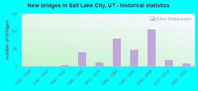
- New bridges - historical statistics
- 11930-1939
- 11940-1949
- 41950-1959
- 411960-1969
- 121970-1979
- 801980-1989
- 481990-1999
- 1062000-2009
- 182010-2019
- 92020-2022
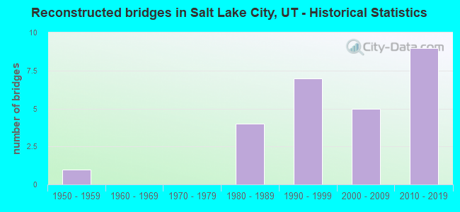
- Reconstructed bridges - Historical Statistics
- 11950-1959
- 01960-1969
- 01970-1979
- 41980-1989
- 71990-1999
- 52000-2009
- 92010-2019

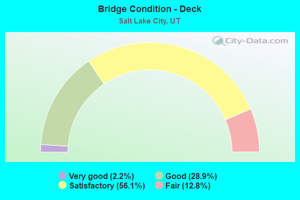
- Bridge Condition - Deck
- 2.2%Very good
- 28.9%Good
- 56.1%Satisfactory
- 12.8%Fair
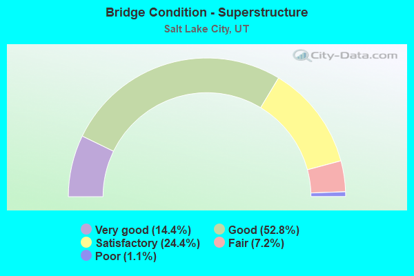
- Bridge Condition - Superstructure
- 14.4%Very good
- 52.8%Good
- 24.4%Satisfactory
- 7.2%Fair
- 1.1%Poor
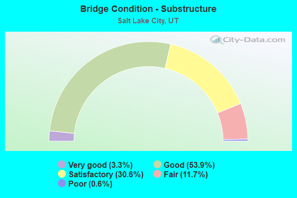
- Bridge Condition - Substructure
- 3.3%Very good
- 53.9%Good
- 30.6%Satisfactory
- 11.7%Fair
- 0.6%Poor
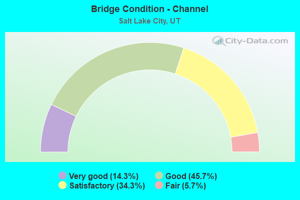
- Bridge Condition - Channel
- 14.3%Very good
- 45.7%Good
- 34.3%Satisfactory
- 5.7%Fair
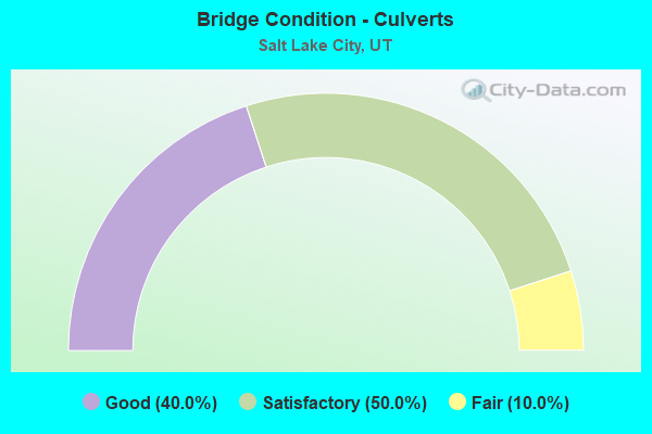
- Bridge Condition - Culverts
- 40.0%Good
- 50.0%Satisfactory
- 10.0%Fair
Find on map >> Show street view
Structure Number: 3F 916, Location: SR-85 (MVC) over SR-201 (Lat: 40.726628, Lng: -112.029339), Route carried "on" structure: State highway 85, Year Built: 2021, Status: Open, Structure Length: 6.46m (21.19ft), Average Daily Traffic: 8,787 (year 2020), Truck Traffic: 16%, Average Future Daily Traffic: 10,984 (year 2040), Design Load: HL 93, Features Intersected: SR-201
Minimum Vertical Clearance: 30+ m (98+ ft), Kilometerpoint: 37.498, Lanes on structure: 2, Lanes under structure: 6, Base Highway Network: Yes, Owner: State Highway Agency, Approaching Roadway Width: 12.8m (42.0ft), Skew: 19 degrees, Material/Design: Concrete, Design/Construction: Stringer/Multi-beam, Number Of Spans In Main Unit: 2, Length of Maximum Span: 37.2m (122.0ft), Curb-To-Curb Width: 12.8m (42.0ft), Out-to-Out Width: 13.7m (44.9ft)
Condition: Deck: Very good, Superstructure: Very good, Substructure: Very good, Operating Rating: 45.4 metric tons, Method Used To Determine Operating Rating: Load and Resistance Factor Rating (LRFR) rating reported by rating factor(RF) method using HL-93 loadings, Inventory Rating: 32.4 metric tons, Method Used To Determine Inventory Rating: Load and Resistance Factor Rating (LRFR) rating reported by rating factor(RF) method using HL-93 loadings, Structural Evaluation: Equal to present desirable criteria, Deck Geometry: Equal to present desirable criteria, Underclear: High priority of corrective action, Approach Roadway Alignment: Equal to present desirable criteria, Designated Inspection Frequency: Every 18 months, Inspection Date: May 2021, Deck Structure Type: Concrete Cast-file-Place, Wearing Surface/Protective System: Wearing Surface: Epoxy Overlay, Deck Protection: Epoxy Coated Reinforcing
Find on map >> Show street view
Structure Number: 3F 917, Location: SR-85 (MVC) over 1730 S (Lat: 40.732586, Lng: -112.029403), Route carried "on" structure: State highway 85, Year Built: 2021, Status: Open, Structure Length: 2.09m (6.86ft), Average Daily Traffic: 8,787 (year 2020), Truck Traffic: 16%, Average Future Daily Traffic: 10,984 (year 2040), Design Load: HL 93, Features Intersected: 1730 S
Minimum Vertical Clearance: 30+ m (98+ ft), Kilometerpoint: 38.318, Lanes on structure: 2, Lanes under structure: 2, Base Highway Network: Yes, Owner: State Highway Agency, Approaching Roadway Width: 12.8m (42.0ft), Skew: 19 degrees, Material/Design: Concrete, Design/Construction: Stringer/Multi-beam, Number Of Spans In Main Unit: 1, Length of Maximum Span: 20.9m (68.6ft), Curb-To-Curb Width: 12.8m (42.0ft), Out-to-Out Width: 17.3m (56.8ft)
Condition: Deck: Very good, Superstructure: Very good, Substructure: Good, Operating Rating: 32.7 metric tons, Method Used To Determine Operating Rating: Load and Resistance Factor Rating (LRFR) rating reported by rating factor(RF) method using HL-93 loadings, Inventory Rating: 32.4 metric tons, Method Used To Determine Inventory Rating: Load and Resistance Factor Rating (LRFR) rating reported by rating factor(RF) method using HL-93 loadings, Structural Evaluation: Better than present minimum criteria, Deck Geometry: Equal to present desirable criteria, Underclear: Somewhat better than minimum adequacy, Approach Roadway Alignment: Equal to present desirable criteria, Designated Inspection Frequency: Every 18 months, Inspection Date: May 2021, Deck Structure Type: Concrete Cast-file-Place, Wearing Surface/Protective System: Wearing Surface: Epoxy Overlay, Membrane: Epoxy, Deck Protection: Epoxy Coated Reinforcing
Find on map >> Show street view
Structure Number: 35122F, Location: SO.OF 7200 W.I-80 INTCHG. (Lat: 40.769117, Lng: -112.063025), Route carried "under" structure: ServiceOther road , Year Built: 1982, Structure Length: 0. m, Average Daily Traffic: 5 (year 2020), Features Intersected: PRIVATE ACCESS ROAD, Facility Carried by Structure: 7200 WEST STREET
Minimum Vertical Clearance: 7.14m (23.43ft), Kilometerpoint: 0.000, Lanes on structure: 5, Lanes under structure: 2, Material/Design: Prestressed concrete, Design/Construction: Stringer/Multi-beam, Length of Maximum Span: 34.4m (112.9ft)
Find on map >> Show street view
Structure Number: 35191C, Location: Salt Lake City Airport (Lat: 40.773386, Lng: -111.985892), Route carried "under" structure: City street 2370, Year Built: 2006, Structure Length: 0. m, Average Daily Traffic: 20,284 (year 2020), Features Intersected: NB.ENTRANCE TO AIRPORT, Facility Carried by Structure: EXIT FROM AIRPORT
Minimum Vertical Clearance: 5.55m (18.21ft), Kilometerpoint: 0.089, Lanes on structure: 2, Lanes under structure: 4, Material/Design: Steel, Design/Construction: Stringer/Multi-beam, Length of Maximum Span: 40.6m (133.2ft)
Find on map >> Show street view
Structure Number: 35192F, Location: Salt Lake City Airport (Lat: 40.774167, Lng: -111.986267), Route carried "under" structure: Alternate City street , Year Built: 2006, Structure Length: 0. m, Average Daily Traffic: 600 (year 2020), Truck Traffic: 1%, Features Intersected: AIRPORT ROAD, Facility Carried by Structure: SB to NB RETURN RD
Minimum Vertical Clearance: 4.60m (15.09ft), Kilometerpoint: 0.000, Lanes on structure: 2, Lanes under structure: 1, Material/Design: Prestressed concrete, Design/Construction: Girder and Floorbeam System, Length of Maximum Span: 23.4m (76.8ft)
Find on map >> Show street view
Structure Number: 35193C, Location: SW of Airport (Lat: 40.777147, Lng: -111.990906), Route carried "under" structure: City street 2370, Year Built: 2005, Structure Length: 0. m, Average Daily Traffic: 20,284 (year 2020), Features Intersected: SB.EXIT FROM AIRPORT, Facility Carried by Structure: ACCESS to PARKING
Minimum Vertical Clearance: 4.70m (15.42ft), Kilometerpoint: 3.360, Lanes on structure: 1, Lanes under structure: 6, Material/Design: Steel, Design/Construction: Stringer/Multi-beam, Length of Maximum Span: 37.5m (123.0ft)
Find on map >> Show street view
Structure Number: 35194C, Location: SLC international airport (Lat: 40.773383, Lng: -111.987303), Route carried "under" structure: Other road 2370, Year Built: 2005, Structure Length: 0. m, Average Daily Traffic: 20,284 (year 2020), Features Intersected: SB. EXIT FROM AIRPORT, Facility Carried by Structure: X-BAR ROAD
Minimum Vertical Clearance: 5.49m (18.01ft), Kilometerpoint: 3.895, Lanes on structure: 2, Lanes under structure: 3, Material/Design: Steel, Design/Construction: Stringer/Multi-beam, Length of Maximum Span: 45.0m (147.6ft)
Find on map >> Show street view
Structure Number: 35195C, Location: SALT LAKE AIRPORT (Lat: 40.777800, Lng: -111.980600), Route carried "under" structure: City street 2370, Year Built: 2006, Structure Length: 0. m, Average Daily Traffic: 20,284 (year 2020), Features Intersected: NB LANES TO AIRPORT, Facility Carried by Structure: AIRPORT SHUTTLE RD
Minimum Vertical Clearance: 4.90m (16.08ft), Kilometerpoint: 0.764, Lanes on structure: 1, Lanes under structure: 5, Material/Design: Steel, Design/Construction: Stringer/Multi-beam, Length of Maximum Span: 38.9m (127.6ft)
Find on map >> Show street view
Structure Number: 35214C, Location: 500 TO 600 W. N.TEMPLE ST (Lat: 40.771467, Lng: -111.906467), Route carried "under" structure: ServiceCity street 2330, Year Built: 2011, Structure Length: 0. m, Average Daily Traffic: 23,197 (year 2020), Features Intersected: UPRR AND UTA-FRONT RUN, Facility Carried by Structure: NORTH TEMPLE ST.
Minimum Vertical Clearance: 5.58m (18.31ft), Kilometerpoint: 4.458, Lanes on structure: 4, Lanes under structure: 2, Material/Design: Steel continuous, Design/Construction: Stringer/Multi-beam, Length of Maximum Span: 59.4m (194.9ft)
Find on map >> Show street view
Structure Number: 35235V, Location: City Creek/Main St Plaza (Lat: 40.769347, Lng: -111.890378), Route carried "under" structure: Business Other road 2328, Year Built: 2007, Structure Length: 0. m, Average Daily Traffic: 12,231 (year 2020), Features Intersected: Parking, Facility Carried by Structure: South Temple
Minimum Vertical Clearance: 3.57m (11.71ft), Kilometerpoint: 1.025, Lanes on structure: 4, Lanes under structure: 2, Toll: Toll bridge, Material/Design: Concrete, Design/Construction: Culvert, Length of Maximum Span: 7.2m (23.6ft)
Find on map >> Show street view
Structure Number: C 369, Location: 1400 WEST 200 SOUTH, SLC (Lat: 40.765350, Lng: -111.932908), Route carried "under" structure: City street 2322, Year Built: 1965, Structure Length: 0. m, Average Daily Traffic: 2,094 (year 2020), Features Intersected: 200 SOUTH STREET, Facility Carried by Structure: I-80 (SR-80)
Minimum Vertical Clearance: 6.63m (21.75ft), Kilometerpoint: 0.000, Lanes on structure: 6, Lanes under structure: 2, Material/Design: Steel continuous, Design/Construction: Stringer/Multi-beam, Length of Maximum Span: 28.7m (94.2ft)
Find on map >> Show street view
Structure Number: C 422, Location: MOUTH OF PARLEYS CANYON (Lat: 40.714561, Lng: -111.807125), Route carried "under" structure: Interstate 80, Year Built: 1966, Structure Length: 0. m, Average Daily Traffic: 37,353 (year 2020), Truck Traffic: 21%, Features Intersected: I-80 (SR-80) EBL AND WB, Facility Carried by Structure: SR-186,FOOTHILL DR
Minimum Vertical Clearance: 5.43m (17.81ft), Kilometerpoint: 205.444, Lanes on structure: 5, Lanes under structure: 5, Material/Design: Steel, Design/Construction: Stringer/Multi-beam, Length of Maximum Span: 28.4m (93.2ft)
Find on map >> Show street view
Structure Number: C 635, Location: 7200 WEST INTERCHANGE (Lat: 40.770603, Lng: -112.063058), Route carried "under" structure: Interstate 80, Year Built: 1982, Structure Length: 0. m, Average Daily Traffic: 25,347 (year 2020), Truck Traffic: 20%, Features Intersected: I-80 (SR-80), Facility Carried by Structure: CO. RD. INT X-ROAD
Minimum Vertical Clearance: 5.05m (16.57ft), Kilometerpoint: 178.961, Lanes on structure: 2, Lanes under structure: 4, Material/Design: Steel continuous, Design/Construction: Stringer/Multi-beam, Length of Maximum Span: 37.2m (122.0ft)
Find on map >> Show street view
Structure Number: C 669, Location: 5600 WEST INTERCHANGE (Lat: 40.770683, Lng: -112.025061), Route carried "under" structure: Interstate 80, Year Built: 1980, Structure Length: 0. m, Average Daily Traffic: 23,579 (year 2020), Truck Traffic: 22%, Features Intersected: I-80 (SR-80) EBL & W, Facility Carried by Structure: SR-172 (5600 W ST)
Minimum Vertical Clearance: 5.26m (17.26ft), Kilometerpoint: 182.300, Lanes on structure: 4, Lanes under structure: 5, Material/Design: Steel continuous, Design/Construction: Stringer/Multi-beam, Length of Maximum Span: 38.4m (126.0ft)
Find on map >> Show street view
Structure Number: C 692, Location: I215-I80 INTCHG.W.OF SLC. (Lat: 40.765061, Lng: -111.950469), Route carried "under" structure: Interstate 80, Year Built: 1985, Structure Length: 0. m, Average Daily Traffic: 63,914 (year 2020), Truck Traffic: 28%, Features Intersected: I-80 (SR-80), Facility Carried by Structure: I-215 (SR-215)
Minimum Vertical Clearance: 5.11m (16.77ft), Kilometerpoint: 188.715, Lanes on structure: 6, Lanes under structure: 10, Material/Design: Steel continuous, Design/Construction: Stringer/Multi-beam, Length of Maximum Span: 52.3m (171.6ft)
Find on map >> Show street view
Structure Number: C 693, Location: 2050 W.NO.TEMPLE ST. SLC. (Lat: 40.771172, Lng: -111.949097), Route carried "under" structure: City street , Year Built: 1983, Structure Length: 0. m, Features Intersected: NORTH TEMPLE ST.in SLC, Facility Carried by Structure: I-215 (SR-215)
Minimum Vertical Clearance: 5.15m (16.90ft), Kilometerpoint: 0.000, Lanes on structure: 8, Lanes under structure: 5, Material/Design: Steel continuous, Design/Construction: Stringer/Multi-beam, Length of Maximum Span: 31.2m (102.4ft)
Find on map >> Show street view
Structure Number: C 704, Location: I215-I80 INTCHG.W.OF SLC. (Lat: 40.762111, Lng: -111.950894), Route carried "under" structure: Ramp Interstate 80, Year Built: 1985, Structure Length: 0. m, Average Daily Traffic: 63,914 (year 2020), Truck Traffic: 28%, Features Intersected: RP.I80W-I215S,I80E-I215N, Facility Carried by Structure: I-215 (SR-215)
Minimum Vertical Clearance: 5.13m (16.83ft), Kilometerpoint: 188.660, Lanes on structure: 6, Lanes under structure: 3, Material/Design: Steel continuous, Design/Construction: Stringer/Multi-beam, Length of Maximum Span: 85.6m (280.8ft)
Find on map >> Show street view
Structure Number: C 774, Location: NO.OF MT. DELL,I-80 INT. (Lat: 40.754256, Lng: -111.711028), Route carried "under" structure: City street 65, Year Built: 1989, Structure Length: 0. m, Average Daily Traffic: 1,617 (year 2020), Truck Traffic: 13%, Features Intersected: SR 65, Facility Carried by Structure: Pedestrian Bridge
Minimum Vertical Clearance: 4.81m (15.78ft), Kilometerpoint: 0.504, Lanes under structure: 2, Material/Design: Steel, Design/Construction: Truss - Thru, Length of Maximum Span: 29.9m (98.1ft)
Find on map >> Show street view
Structure Number: C 816, Location: 600 NO.INTERCHANGE IN SLC (Lat: 40.782372, Lng: -111.911247), Route carried "under" structure: Interstate 15, Year Built: 1998, Structure Length: 0. m, Average Daily Traffic: 138,982 (year 2020), Truck Traffic: 9%, Features Intersected: I-15 (SR-15) NBL & S, Facility Carried by Structure: SR-268 (600 NORTH)
Minimum Vertical Clearance: 5.62m (18.44ft), Kilometerpoint: 497.439, Lanes on structure: 6, Lanes under structure: 12, Material/Design: Steel continuous, Design/Construction: Stringer/Multi-beam, Length of Maximum Span: 32.2m (105.6ft)
Find on map >> Show street view
Structure Number: C 891, Location: NEAR MOUTH OF PARLEYS CYN (Lat: 40.708403, Lng: -111.796089), Route carried "under" structure: Ramp Interstate 80, Year Built: 1999, Structure Length: 0. m, Average Daily Traffic: 35,149 (year 2020), Truck Traffic: 22%, Features Intersected: RAMP,I-80WB TO I-215SB, Facility Carried by Structure: PEDESTRIAN O'P
Minimum Vertical Clearance: 5.22m (17.13ft), Kilometerpoint: 206.302, Lanes under structure: 2, Material/Design: Steel, Design/Construction: Box Beam or Girders - Single/Spread, Length of Maximum Span: 35.0m (114.8ft)
Find on map >> Show street view
Structure Number: C 921, Location: 350 SO. WASATCH DRIVE (Lat: 40.765167, Lng: -111.836814), Route carried "under" structure: State highway 282, Year Built: 2001, Structure Length: 0. m, Average Daily Traffic: 32,415 (year 2020), Truck Traffic: 10%, Features Intersected: SR-282, Facility Carried by Structure: PEDESTRIAN WALKWAY
Minimum Vertical Clearance: 5.76m (18.90ft), Kilometerpoint: 2.630, Lanes under structure: 6, Material/Design: Steel continuous, Design/Construction: Stayed Girder, Length of Maximum Span: 51.8m (169.9ft)
Find on map >> Show street view
Structure Number: C 968, Location: At 3300 So.Int.with I-215 (Lat: 40.699844, Lng: -111.795589), Route carried "under" structure: Interstate 215, Year Built: 2008, Structure Length: 0. m, Average Daily Traffic: 78,343 (year 2020), Truck Traffic: 13%, Features Intersected: I-215 NB AND SB, Facility Carried by Structure: SR-171 ,3300 SOUTH
Minimum Vertical Clearance: 5.32m (17.45ft), Kilometerpoint: 2.972, Lanes on structure: 4, Lanes under structure: 6, Material/Design: Steel, Design/Construction: Stringer/Multi-beam, Length of Maximum Span: 46.6m (152.9ft)
Find on map >> Show street view
Structure Number: C1031, Location: U of U Campus (Lat: 40.767414, Lng: -111.847258), Route carried "under" structure: State highway 282, Year Built: 2015, Structure Length: 0. m, Average Daily Traffic: 11,506 (year 2020), Truck Traffic: 10%, Features Intersected: SR-282, N Campus Dr, Facility Carried by Structure: Pedestrians
Minimum Vertical Clearance: 6.09m (19.98ft), Kilometerpoint: 4.719, Lanes under structure: 4, Material/Design: Steel, Design/Construction: Truss - Thru, Length of Maximum Span: 32.7m (107.3ft)
Find on map >> Show street view
Structure Number: F 34, Location: 200 SOUTH REDWOOD RD. SLC (Lat: 40.764681, Lng: -111.939114), Route carried "under" structure: City street 2322, Year Built: 1972, Structure Length: 0. m, Average Daily Traffic: 2,094 (year 2020), Features Intersected: 200 SOUTH STREET, Facility Carried by Structure: SR-68, REDWOOD RD.
Minimum Vertical Clearance: 7.77m (25.49ft), Kilometerpoint: 0.000, Lanes on structure: 4, Lanes under structure: 2, Material/Design: Prestressed concrete, Design/Construction: Stringer/Multi-beam, Length of Maximum Span: 18.0m (59.1ft)
Find on map >> Show street view
Structure Number: F 35, Location: 170 SOUTH REDWOOD RD. SLC (Lat: 40.765808, Lng: -111.939119), Route carried "under" structure: Interstate 80, Year Built: 1972, Structure Length: 0. m, Average Daily Traffic: 56,187 (year 2020), Truck Traffic: 17%, Features Intersected: I-80 (SR-80),EBL & W, Facility Carried by Structure: SR-68, REDWOOD RD.
Minimum Vertical Clearance: 5.41m (17.75ft), Kilometerpoint: 189.681, Lanes on structure: 4, Lanes under structure: 6, Material/Design: Prestressed concrete, Design/Construction: Stringer/Multi-beam, Length of Maximum Span: 23.2m (76.1ft)
Find on map >> Show street view
Structure Number: F 48, Location: 1300 EAST INTERCHANGE SLC (Lat: 40.719047, Lng: -111.853631), Route carried "under" structure: Interstate 80, Year Built: 1964, Structure Length: 0. m, Average Daily Traffic: 110,237 (year 2020), Truck Traffic: 16%, Features Intersected: I-80 (SR-80) EBL & W, Facility Carried by Structure: 1300 EAST
Minimum Vertical Clearance: 4.82m (15.81ft), Kilometerpoint: 201.282, Lanes on structure: 6, Lanes under structure: 6, Material/Design: Prestressed concrete, Design/Construction: Stringer/Multi-beam, Length of Maximum Span: 23.0m (75.5ft)
Find on map >> Show street view
Structure Number: F 49, Location: 2400 SO & 1700 EAST (Lat: 40.718450, Lng: -111.842111), Route carried "under" structure: Interstate 80, Year Built: 1964, Structure Length: 0. m, Average Daily Traffic: 90,775 (year 2020), Truck Traffic: 18%, Features Intersected: I-80 (SR-80) EBL & W, Facility Carried by Structure: 1700 EAST STREET
Minimum Vertical Clearance: 4.60m (15.09ft), Kilometerpoint: 202.267, Lanes on structure: 2, Lanes under structure: 6, Material/Design: Prestressed concrete, Design/Construction: Stringer/Multi-beam, Length of Maximum Span: 22.1m (72.5ft)
Find on map >> Show street view
Structure Number: F 431, Location: 2200 NORTH INTCHG.IN SLC. (Lat: 40.813106, Lng: -111.949772), Route carried "under" structure: Interstate 215, Year Built: 1986, Structure Length: 0. m, Average Daily Traffic: 64,958 (year 2020), Truck Traffic: 16%, Features Intersected: I-215 (SR-215) NBL &, Facility Carried by Structure: INTCHG. X-ROAD.
Minimum Vertical Clearance: 5.08m (16.67ft), Kilometerpoint: 41.223, Lanes on structure: 2, Lanes under structure: 5, Material/Design: Prestressed concrete continuous, Design/Construction: Stringer/Multi-beam, Length of Maximum Span: 35.2m (115.5ft)
Find on map >> Show street view
Structure Number: F 47, Location: 2000 W.1700 NORTH, SLC. (Lat: 40.805653, Lng: -111.949664), Route carried "under" structure: Interstate 215, Year Built: 1986, Structure Length: 0. m, Average Daily Traffic: 68,995 (year 2020), Truck Traffic: 15%, Features Intersected: I-215(SR-215) and DR.C, Facility Carried by Structure: 1700 NORTH STREET
Minimum Vertical Clearance: 5.28m (17.32ft), Kilometerpoint: 40.419, Lanes on structure: 2, Lanes under structure: 6, Material/Design: Prestressed concrete continuous, Design/Construction: Stringer/Multi-beam, Length of Maximum Span: 39.9m (130.9ft)
Find on map >> Show street view
Structure Number: F 477, Location: 2400 W.1700 SOUTH, SLC (Lat: 40.732867, Lng: -111.949481), Route carried "under" structure: City street 2254, Year Built: 1988, Structure Length: 0. m, Average Daily Traffic: 7,178 (year 2020), Features Intersected: 1700 SOUTH STREET, Facility Carried by Structure: I-215 (SR-215)
Minimum Vertical Clearance: 5.07m (16.63ft), Kilometerpoint: 0.000, Lanes on structure: 10, Lanes under structure: 4, Material/Design: Prestressed concrete, Design/Construction: Stringer/Multi-beam, Length of Maximum Span: 42.7m (140.1ft)
Find on map >> Show street view
Structure Number: F 5, Location: 2000 W.700 NO.INTCHG.,SLC (Lat: 40.784519, Lng: -111.948967), Route carried "under" structure: City street 2354, Year Built: 1984, Structure Length: 0. m, Average Daily Traffic: 7,508 (year 2020), Features Intersected: 700 NORTH STREET, Facility Carried by Structure: I-215 (SR-215)
Minimum Vertical Clearance: 4.93m (16.17ft), Kilometerpoint: 0.000, Lanes on structure: 6, Lanes under structure: 4, Material/Design: Prestressed concrete, Design/Construction: Stringer/Multi-beam, Length of Maximum Span: 42.7m (140.1ft)
Find on map >> Show street view
Structure Number: F 791, Location: 1000 North 900 West - SLC (Lat: 40.793836, Lng: -111.917417), Route carried "under" structure: Interstate 15, Year Built: 2010, Structure Length: 0. m, Average Daily Traffic: 117,697 (year 2020), Truck Traffic: 10%, Features Intersected: I-15, (SR-15), Facility Carried by Structure: INTCHG. X-ROAD
Minimum Vertical Clearance: 5.36m (17.59ft), Kilometerpoint: 499.254, Lanes on structure: 2, Lanes under structure: 8, Material/Design: Prestressed concrete continuous, Design/Construction: Stringer/Multi-beam, Length of Maximum Span: 43.1m (141.4ft)
Find on map >> Show street view
Structure Number: 1C 628, Location: AIRPORT INTERCHANGE-SLC (Lat: 40.763539, Lng: -111.986675), Route carried "under" structure: Interstate 80, Year Built: 1986, Structure Length: 0. m, Average Daily Traffic: 55,886 (year 2020), Truck Traffic: 26%, Features Intersected: I-80 (SR-80) EBL & W, Facility Carried by Structure: SR-154NB,(BNGTR.H)
Minimum Vertical Clearance: 5.18m (16.99ft), Kilometerpoint: 185.678, Lanes on structure: 3, Lanes under structure: 11, Material/Design: Steel continuous, Design/Construction: Stringer/Multi-beam, Length of Maximum Span: 73.5m (241.1ft)
Find on map >> Show street view
Structure Number: 1C 698, Location: 500 SO.2000 WEST, SLC. (Lat: 40.757861, Lng: -111.949839), Route carried "under" structure: City street , Year Built: 1987, Structure Length: 0. m, Average Daily Traffic: 6,600 (year 2020), Features Intersected: 500 SO.ST. AND UPRR, Facility Carried by Structure: RP.I215NB TO I80EB
Minimum Vertical Clearance: 6.86m (22.51ft), Kilometerpoint: 0.000, Lanes on structure: 2, Lanes under structure: 4, Material/Design: Steel, Design/Construction: Stringer/Multi-beam, Length of Maximum Span: 45.6m (149.6ft)
Find on map >> Show street view
Structure Number: 1C 7, Location: I215-I80,INTCHG.W.OF SLC. (Lat: 40.763014, Lng: -111.950028), Route carried "under" structure: Interstate 80, Year Built: 1985, Structure Length: 0. m, Average Daily Traffic: 61,595 (year 2014), Truck Traffic: 20%, Features Intersected: I-215,I-80 & 4 INT.R
Minimum Vertical Clearance: 5.17m (16.96ft), Kilometerpoint: 188.374, Lanes on structure: 1, Lanes under structure: 10, Material/Design: Steel continuous, Design/Construction: Stringer/Multi-beam, Length of Maximum Span: 54.4m (178.5ft)
Find on map >> Show street view
Structure Number: 1C 7, Location: I215-I80,INTCHG.W.OF SLC. (Lat: 40.763014, Lng: -111.950028), Route carried "under" structure: Interstate 215, Year Built: 1985, Structure Length: 0. m, Average Daily Traffic: 87,424 (year 2020), Truck Traffic: 14%, Features Intersected: I-215,I-80 & 4 INT.R
Minimum Vertical Clearance: 5.17m (16.96ft), Kilometerpoint: 35.752, Lanes on structure: 1, Lanes under structure: 17, Material/Design: Steel continuous, Design/Construction: Stringer/Multi-beam, Length of Maximum Span: 54.4m (178.5ft)
Find on map >> Show street view
Structure Number: 1C 701, Location: I215-I80 INTCHG.W.OF SLC. (Lat: 40.764331, Lng: -111.948403), Route carried "under" structure: Ramp Interstate 80, Year Built: 1985, Structure Length: 0. m, Average Daily Traffic: 63,914 (year 2020), Truck Traffic: 28%, Features Intersected: I-80 (SR-80)EBL OFF-RAMP
Minimum Vertical Clearance: 5.28m (17.32ft), Kilometerpoint: 188.744, Lanes on structure: 2, Lanes under structure: 1, Material/Design: Steel continuous, Design/Construction: Stringer/Multi-beam, Length of Maximum Span: 32.3m (106.0ft)
Find on map >> Show street view
Structure Number: 1C 738, Location: 700 SOUTH 4000 WEST, SLC (Lat: 40.754381, Lng: -111.986764), Route carried "under" structure: City street , Year Built: 1985, Structure Length: 0. m, Average Daily Traffic: 1,400 (year 2020), Features Intersected: 700 SOUTH STREET, Facility Carried by Structure: SR-154NB,(BNGTR.H)
Minimum Vertical Clearance: 9.88m (32.41ft), Kilometerpoint: 0.000, Lanes on structure: 2, Lanes under structure: 2, Material/Design: Steel continuous, Design/Construction: Stringer/Multi-beam, Length of Maximum Span: 38.3m (125.7ft)
Find on map >> Show street view
Structure Number: 1C 868N, Location: 650 WEST 900 SO.ST.,SLC. (Lat: 40.748914, Lng: -111.908317), Route carried "under" structure: City street , Year Built: 1999, Structure Length: 0. m, Average Daily Traffic: 10,000 (year 2020), Features Intersected: 900 South & UPRR, Facility Carried by Structure: I-15 (SR-15) NBL
Minimum Vertical Clearance: 7.34m (24.08ft), Kilometerpoint: 0.000, Lanes on structure: 7, Lanes under structure: 2, Material/Design: Steel, Design/Construction: Stringer/Multi-beam, Length of Maximum Span: 47.6m (156.2ft)
Find on map >> Show street view
Structure Number: 1C 875N, Location: 700 WEST 400 SOUTH ST. (Lat: 40.759961, Lng: -111.913872), Route carried "under" structure: State highway 267, Year Built: 1999, Structure Length: 0. m, Average Daily Traffic: 6,800 (year 2020), Features Intersected: SR-267, 400 SO. ST., Facility Carried by Structure: I-15 (SR-15) NBL
Minimum Vertical Clearance: 5.31m (17.42ft), Kilometerpoint: 0.222, Lanes on structure: 4, Lanes under structure: 7, Material/Design: Steel continuous, Design/Construction: Stringer/Multi-beam, Length of Maximum Span: 69.1m (226.7ft)
Find on map >> Show street view
Structure Number: 1C 880N, Location: APPROX.600 W.SO.TEMP.SLC. (Lat: 40.767758, Lng: -111.912003), Route carried "under" structure: City street , Year Built: 1999, Structure Length: 0. m, Features Intersected: UPRR & SOUTH TEMPLE, Facility Carried by Structure: I-15 (SR-15) NBL
Minimum Vertical Clearance: 7.70m (25.26ft), Kilometerpoint: 0.000, Lanes on structure: 6, Lanes under structure: 2, Material/Design: Steel continuous, Design/Construction: Stringer/Multi-beam, Length of Maximum Span: 55.5m (182.1ft)
Find on map >> Show street view
Structure Number: 1C 931, Location: 3300 E. 3800 SO. SLC (Lat: 40.689014, Lng: -111.797297), Route carried "under" structure: City street 2192, Year Built: 2004, Structure Length: 0. m, Average Daily Traffic: 2,232 (year 2020), Features Intersected: 3800 SOUTH STREET, Facility Carried by Structure: I-215 (SR-215) NB
Minimum Vertical Clearance: 5.00m (16.40ft), Kilometerpoint: 0.000, Lanes on structure: 3, Lanes under structure: 2, Material/Design: Steel, Design/Construction: Stringer/Multi-beam, Length of Maximum Span: 32.0m (105.0ft)
Find on map >> Show street view
Structure Number: 1D 672, Location: BECK STREET INTERCHANGE (Lat: 40.818372, Lng: -111.916339), Route carried "under" structure: Ramp Interstate 15, Year Built: 1961, Structure Length: 0. m, Average Daily Traffic: 23,546 (year 2020), Truck Traffic: 25%, Features Intersected: RAMP,I-15NB to US-89NB
Minimum Vertical Clearance: 4.67m (15.32ft), Kilometerpoint: 0.370, Lanes on structure: 1, Lanes under structure: 1, Material/Design: Concrete continuous, Design/Construction: Box Beam or Girders - Multiple, Length of Maximum Span: 31.7m (104.0ft)
Find on map >> Show street view
Structure Number: 1F 633N, Location: 400 WEST 1700 SOUTH, SLC. (Lat: 40.733186, Lng: -111.904544), Route carried "under" structure: City street , Year Built: 2000, Structure Length: 0. m, Features Intersected: 1700 SOUTH STREET, Facility Carried by Structure: I-15 (SR-15) NBL
Minimum Vertical Clearance: 5.13m (16.83ft), Kilometerpoint: 0.000, Lanes on structure: 5, Lanes under structure: 4, Material/Design: Prestressed concrete, Design/Construction: Stringer/Multi-beam, Length of Maximum Span: 41.3m (135.5ft)
Find on map >> Show street view
Structure Number: 1F 634, Location: 400 WEST 1700 SOUTH, SLC. (Lat: 40.733214, Lng: -111.904214), Route carried "under" structure: City street , Year Built: 1999, Structure Length: 0. m, Features Intersected: 1700 SOUTH STREET, Facility Carried by Structure: I-15 NB COL-DIST.
Minimum Vertical Clearance: 5.11m (16.77ft), Kilometerpoint: 0.000, Lanes on structure: 4, Lanes under structure: 4, Material/Design: Prestressed concrete, Design/Construction: Stringer/Multi-beam, Length of Maximum Span: 41.3m (135.5ft)
Find on map >> Show street view
Structure Number: 1F 636N, Location: APPROX.450 W.1200 SO.SLC. (Lat: 40.745117, Lng: -111.904311), Route carried "under" structure: Ramp State highway 270, Year Built: 1999, Structure Length: 0. m, Average Daily Traffic: 26,175 (year 2020), Truck Traffic: 7%, Features Intersected: SR-270, SBL, Facility Carried by Structure: I-15 (SR-15) NBL
Minimum Vertical Clearance: 5.64m (18.50ft), Kilometerpoint: 0.805, Lanes on structure: 7, Lanes under structure: 2, Material/Design: Prestressed concrete continuous, Design/Construction: Stringer/Multi-beam, Length of Maximum Span: 26.2m (86.0ft)
Find on map >> Show street view
Structure Number: 1F 637N, Location: APPROX.450 W.1000 SO.SLC. (Lat: 40.747117, Lng: -111.906142), Route carried "under" structure: City street , Year Built: 1999, Structure Length: 0. m, Features Intersected: 500 WEST STREET & UP, Facility Carried by Structure: I-15 (SR-15) NBL
Minimum Vertical Clearance: 8.35m (27.40ft), Kilometerpoint: 0.000, Lanes on structure: 6, Lanes under structure: 2, Material/Design: Prestressed concrete continuous, Design/Construction: Stringer/Multi-beam, Length of Maximum Span: 34.2m (112.2ft)
Find on map >> Show street view
Structure Number: 1F 655N, Location: 1300 SOUTH INTCHG.IN SLC. (Lat: 40.741189, Lng: -111.904083), Route carried "under" structure: City street , Year Built: 1999, Structure Length: 0. m, Features Intersected: 1300 SOUTH STREET, Facility Carried by Structure: I-15 (SR-15) NBL
Minimum Vertical Clearance: 5.36m (17.59ft), Kilometerpoint: 0.000, Lanes on structure: 5, Lanes under structure: 8, Material/Design: Prestressed concrete continuous, Design/Construction: Stringer/Multi-beam, Length of Maximum Span: 34.3m (112.5ft)
Find on map >> Show street view
Structure Number: 1F 656, Location: 450 WEST 1300 SO.ST.,SLC. (Lat: 40.741217, Lng: -111.903303), Route carried "under" structure: City street , Year Built: 2000, Structure Length: 0. m, Features Intersected: 1300 SOUTH STREET, Facility Carried by Structure: I-15NB RP.to SR270
Minimum Vertical Clearance: 5.15m (16.90ft), Kilometerpoint: 0.000, Lanes on structure: 2, Lanes under structure: 6, Material/Design: Prestressed concrete continuous, Design/Construction: Stringer/Multi-beam, Length of Maximum Span: 34.2m (112.2ft)
Find on map >> Show street view
Structure Number: 1F 658N, Location: 550 WEST 800 SO.ST.,SLC. (Lat: 40.751589, Lng: -111.910453), Route carried "under" structure: City street , Year Built: 1999, Structure Length: 0. m, Features Intersected: 800 SOUTH STREET, Facility Carried by Structure: I-15 (SR-15) NBL
Minimum Vertical Clearance: 5.18m (16.99ft), Kilometerpoint: 0.000, Lanes on structure: 7, Lanes under structure: 4, Material/Design: Prestressed concrete continuous, Design/Construction: Stringer/Multi-beam, Length of Maximum Span: 30.9m (101.4ft)
Find on map >> Show street view
Structure Number: 1F 659, Location: APPROX.300 SO.700 W.,SLC (Lat: 40.763142, Lng: -111.913925), Route carried "under" structure: Interstate 80, Year Built: 1999, Structure Length: 0. m, Average Daily Traffic: 56,191 (year 2020), Truck Traffic: 15%, Features Intersected: I-80 (SR-80) WBL, Facility Carried by Structure: I-15 (SR-15) NBL
Minimum Vertical Clearance: 5.36m (17.59ft), Kilometerpoint: 192.194, Lanes on structure: 6, Lanes under structure: 3, Material/Design: Prestressed concrete continuous, Design/Construction: Stringer/Multi-beam, Length of Maximum Span: 34.0m (111.5ft)
Find on map >> Show street view
Structure Number: 1F 660N, Location: 700 WEST 200 SOUTH ST.SLC (Lat: 40.764567, Lng: -111.913406), Route carried "under" structure: City street 2322, Year Built: 1999, Structure Length: 0. m, Average Daily Traffic: 2,094 (year 2020), Features Intersected: 200 SOUTH STREET, Facility Carried by Structure: I-15 (SR-15) NBL
Minimum Vertical Clearance: 5.92m (19.42ft), Kilometerpoint: 0.000, Lanes on structure: 6, Lanes under structure: 5, Material/Design: Prestressed concrete continuous, Design/Construction: Stringer/Multi-beam, Length of Maximum Span: 30.0m (98.4ft)
Find on map >> Show street view
Structure Number: 1F 661N, Location: 700 West, No.Temple Str. (Lat: 40.771053, Lng: -111.910594), Route carried "under" structure: City street , Year Built: 1999, Structure Length: 0. m, Features Intersected: No. Temple & UTA Tracks, Facility Carried by Structure: I-15 (SR-15) NBL
Minimum Vertical Clearance: 5.08m (16.67ft), Kilometerpoint: 0.000, Lanes on structure: 5, Lanes under structure: 6, Material/Design: Prestressed concrete continuous, Design/Construction: Stringer/Multi-beam, Length of Maximum Span: 47.1m (154.5ft)
Find on map >> Show street view
Structure Number: 1F 662N, Location: 600 WEST 300 NORTH ST SLC (Lat: 40.775536, Lng: -111.910236), Route carried "under" structure: City street 2364, Year Built: 1999, Structure Length: 0. m, Average Daily Traffic: 3,376 (year 2020), Features Intersected: 300 NORTH STREET, Facility Carried by Structure: I-15 (SR-15) NBL
Minimum Vertical Clearance: 5.36m (17.59ft), Kilometerpoint: 0.000, Lanes on structure: 5, Lanes under structure: 2, Material/Design: Prestressed concrete continuous, Design/Construction: Stringer/Multi-beam, Length of Maximum Span: 24.0m (78.7ft)
Find on map >> Show street view
Structure Number: 1F 774, Location: 2300 No.Becks St.in SLC (Lat: 40.815825, Lng: -111.920472), Route carried "under" structure: US 89, Year Built: 2010, Structure Length: 0. m, Average Daily Traffic: 20,947 (year 2020), Features Intersected: US-89SB,UPRR&UTA, Facility Carried by Structure: I-15 (SR-15) NB
Minimum Vertical Clearance: 5.69m (18.67ft), Kilometerpoint: 617.480, Lanes on structure: 5, Lanes under structure: 2, Material/Design: Prestressed concrete continuous, Design/Construction: Stringer/Multi-beam, Length of Maximum Span: 59.9m (196.5ft)
Find on map >> Show street view
Structure Number: 2C 4, Location: 1000 SO 400 WEST SLC (Lat: 40.747456, Lng: -111.902442), Route carried "under" structure: City street , Year Built: 1967, Structure Length: 0. m, Features Intersected: 400 WEST STREET, Facility Carried by Structure: I-15Ramp to SR-270
Minimum Vertical Clearance: 7.16m (23.49ft), Kilometerpoint: 0.000, Lanes on structure: 2, Lanes under structure: 2, Material/Design: Steel, Design/Construction: Stringer/Multi-beam, Length of Maximum Span: 19.3m (63.3ft)
Find on map >> Show street view
Structure Number: 2C 402, Location: 990 SO 200 WEST SLC (Lat: 40.747361, Lng: -111.897225), Route carried "under" structure: City street , Year Built: 1967, Structure Length: 0. m, Features Intersected: 200 W. and WEST TEMPLE, Facility Carried by Structure: I-15Ramp to SR-270
Minimum Vertical Clearance: 4.52m (14.83ft), Kilometerpoint: 0.000, Lanes on structure: 2, Lanes under structure: 4, Material/Design: Steel, Design/Construction: Stringer/Multi-beam, Length of Maximum Span: 21.1m (69.2ft)
Find on map >> Show street view
Structure Number: 2C 421, Location: I-215 INT. PARLEYS CANYON (Lat: 40.712675, Lng: -111.818464), Route carried "under" structure: Interstate 215, Year Built: 1967, Structure Length: 0. m, Average Daily Traffic: 25,500 (year 2020), Truck Traffic: 15%, Features Intersected: SR-215(SR-215)WBL, Facility Carried by Structure: I-80(SR-80)EBL
Minimum Vertical Clearance: 4.75m (15.58ft), Kilometerpoint: 0.002, Lanes on structure: 2, Lanes under structure: 2, Material/Design: Steel, Design/Construction: Stringer/Multi-beam, Length of Maximum Span: 23.4m (76.8ft)
Find on map >> Show street view
Structure Number: 2C 624, Location: 1 MI.EAST SL.AIRPORT INT. (Lat: 40.763925, Lng: -111.966261), Route carried "under" structure: Interstate 80, Year Built: 1984, Structure Length: 0. m, Average Daily Traffic: 63,914 (year 2020), Truck Traffic: 28%, Features Intersected: I-80,RAMP and SURPLUS
Minimum Vertical Clearance: 5.13m (16.83ft), Kilometerpoint: 187.344, Lanes on structure: 2, Lanes under structure: 10, Material/Design: Steel continuous, Design/Construction: Stringer/Multi-beam, Length of Maximum Span: 62.2m (204.1ft)
Find on map >> Show street view
Structure Number: 2C 631, Location: AIRPORT INTERCHANGE, SLC. (Lat: 40.763800, Lng: -111.982989), Route carried "under" structure: Ramp State highway 154, Year Built: 1986, Structure Length: 0. m, Average Daily Traffic: 28,445 (year 2020), Truck Traffic: 16%, Features Intersected: RP.SR-154NB TO I-80EB, Facility Carried by Structure: RP.I80EtoN.Tpl.RP
Minimum Vertical Clearance: 5.11m (16.77ft), Kilometerpoint: 35.000, Lanes on structure: 1, Lanes under structure: 1, Material/Design: Steel, Design/Construction: Stringer/Multi-beam, Length of Maximum Span: 75.9m (249.0ft)
Find on map >> Show street view
Structure Number: 2C 633, Location: I-80, Airport Int. (Lat: 40.769958, Lng: -111.986714), Route carried "under" structure: State highway 154, Year Built: 1986, Structure Length: 0. m, Average Daily Traffic: 19,143 (year 2020), Truck Traffic: 15%, Features Intersected: SR-154 NBL (40TH W.)
Minimum Vertical Clearance: 5.08m (16.67ft), Kilometerpoint: 36.675, Lanes on structure: 2, Lanes under structure: 2, Material/Design: Steel continuous, Design/Construction: Stringer/Multi-beam, Length of Maximum Span: 81.1m (266.1ft)
Find on map >> Show street view
Structure Number: 2C 637, Location: I-80, AIRPORT INTERCHANGE (Lat: 40.765606, Lng: -111.983150), Route carried "under" structure: Interstate 80, Year Built: 1986, Structure Length: 0. m, Average Daily Traffic: 55,886 (year 2020), Truck Traffic: 26%, Features Intersected: I-80 (SR-80) & RAMPS
Minimum Vertical Clearance: 5.19m (17.03ft), Kilometerpoint: 185.895, Lanes on structure: 2, Lanes under structure: 9, Material/Design: Steel continuous, Design/Construction: Stringer/Multi-beam, Length of Maximum Span: 104.9m (344.2ft)
Find on map >> Show street view
Structure Number: 2C 702, Location: I215-I80 INTCHG.W.OF SLC. (Lat: 40.764650, Lng: -111.949714), Route carried "under" structure: Interstate 80, Year Built: 1985, Structure Length: 0. m, Average Daily Traffic: 63,914 (year 2020), Truck Traffic: 28%, Features Intersected: I-80 (SR-80) EBL and W
Minimum Vertical Clearance: 5.66m (18.57ft), Kilometerpoint: 188.795, Lanes on structure: 1, Lanes under structure: 9, Material/Design: Steel continuous, Design/Construction: Stringer/Multi-beam, Length of Maximum Span: 51.2m (168.0ft)
Find on map >> Show street view
Structure Number: 2C 732, Location: I-80, 4800 WEST INTCHG. (Lat: 40.770383, Lng: -112.005689), Route carried "under" structure: Interstate 80, Year Built: 1987, Structure Length: 0. m, Average Daily Traffic: 38,151 (year 2020), Truck Traffic: 24%, Features Intersected: I-80 (SR-80) EBL & WBL
Minimum Vertical Clearance: 5.21m (17.09ft), Kilometerpoint: 183.951, Lanes on structure: 2, Lanes under structure: 7, Material/Design: Steel continuous, Design/Construction: Stringer/Multi-beam, Length of Maximum Span: 70.7m (232.0ft)
Find on map >> Show street view
Structure Number: 2C 871, Location: 6TH SO.,I-15 INT. in SLC. (Lat: 40.757797, Lng: -111.914522), Route carried "under" structure: Ramp State highway 269, Year Built: 2000, Structure Length: 0. m, Average Daily Traffic: 44,626 (year 2020), Truck Traffic: 24%, Features Intersected: I-15, I-15 RAMPS, UPRR
Minimum Vertical Clearance: 5.31m (17.42ft), Kilometerpoint: 0.414, Lanes on structure: 2, Lanes under structure: 2, Material/Design: Steel continuous, Design/Construction: Stringer/Multi-beam, Length of Maximum Span: 68.9m (226.0ft)
Find on map >> Show street view
Structure Number: 2C 876, Location: 700 WEST 400 SOUTH, SLC. (Lat: 40.761378, Lng: -111.915283), Route carried "under" structure: State highway 267, Year Built: 2000, Structure Length: 0. m, Average Daily Traffic: 6,800 (year 2020), Features Intersected: SR-267, 400 SOUTH ST., Facility Carried by Structure: I-80 (SR-80) EBL
Minimum Vertical Clearance: 5.36m (17.59ft), Kilometerpoint: 0.220, Lanes on structure: 3, Lanes under structure: 6, Material/Design: Steel continuous, Design/Construction: Stringer/Multi-beam, Length of Maximum Span: 50.4m (165.4ft)
Find on map >> Show street view
Structure Number: 2C 884, Location: 200 SOUTH INTERCHANGE,SLC (Lat: 40.763900, Lng: -111.917450), Route carried "under" structure: Interstate 15, Year Built: 2000, Structure Length: 0. m, Average Daily Traffic: 192,683 (year 2020), Truck Traffic: 10%, Features Intersected: I-80,I-15,900 W.& 20
Minimum Vertical Clearance: 5.18m (16.99ft), Kilometerpoint: 490.369, Lanes on structure: 1, Lanes under structure: 20, Material/Design: Steel continuous, Design/Construction: Stringer/Multi-beam, Length of Maximum Span: 100.0m (328.1ft)
Find on map >> Show street view
Structure Number: 2C 884, Location: 200 SOUTH INTERCHANGE,SLC (Lat: 40.763900, Lng: -111.917450), Route carried "under" structure: Interstate 80, Year Built: 2000, Structure Length: 0. m, Average Daily Traffic: 61,660 (year 2014), Truck Traffic: 15%, Features Intersected: I-80,I-15,900 W.& 20
Minimum Vertical Clearance: 5.33m (17.49ft), Kilometerpoint: 191.423, Lanes on structure: 1, Lanes under structure: 20, Material/Design: Steel continuous, Design/Construction: Stringer/Multi-beam, Length of Maximum Span: 100.0m (328.1ft)
Find on map >> Show street view
Structure Number: 2C 887, Location: 270 SOUTH 900 WEST, SLC. (Lat: 40.764317, Lng: -111.917300), Route carried "under" structure: City street , Year Built: 2000, Structure Length: 0. m, Average Daily Traffic: 12,000 (year 2020), Features Intersected: 900 WEST STREET, Facility Carried by Structure: I-80 (SR-80) EBL
Minimum Vertical Clearance: 5.28m (17.32ft), Kilometerpoint: 0.000, Lanes on structure: 3, Lanes under structure: 4, Material/Design: Steel, Design/Construction: Stringer/Multi-beam, Length of Maximum Span: 48.5m (159.1ft)
Find on map >> Show street view
Structure Number: 2C 958, Location: At 700 E.Int. at 2400 So. (Lat: 40.718550, Lng: -111.871658), Route carried "under" structure: State highway 71, Year Built: 2008, Structure Length: 0. m, Average Daily Traffic: 31,271 (year 2020), Truck Traffic: 10%, Features Intersected: SR-71,700 EAST ST.in SLC, Facility Carried by Structure: I-80, (SR-80) EBL
Minimum Vertical Clearance: 5.74m (18.83ft), Kilometerpoint: 27.562, Lanes on structure: 4, Lanes under structure: 10, Material/Design: Steel, Design/Construction: Stringer/Multi-beam, Length of Maximum Span: 51.5m (169.0ft)
Find on map >> Show street view
Structure Number: 2C 959, Location: 2400 So. 900 East. in SLC (Lat: 40.719281, Lng: -111.865728), Route carried "under" structure: City street , Year Built: 2008, Structure Length: 0. m, Average Daily Traffic: 9,200 (year 2020), Features Intersected: 900 EAST STREET in SLC, Facility Carried by Structure: I-80, (SR-80) EBL
Minimum Vertical Clearance: 4.82m (15.81ft), Kilometerpoint: 0.000, Lanes on structure: 5, Lanes under structure: 2, Material/Design: Steel, Design/Construction: Stringer/Multi-beam, Length of Maximum Span: 35.7m (117.1ft)
Find on map >> Show street view
Structure Number: 2C 96, Location: 2400 So. 600 East in SLC (Lat: 40.718236, Lng: -111.874258), Route carried "under" structure: City street , Year Built: 2008, Structure Length: 0. m, Features Intersected: 600 EAST STREET IN SLC, Facility Carried by Structure: I-80 (SR-80) EBL
Minimum Vertical Clearance: 5.46m (17.91ft), Kilometerpoint: 0.000, Lanes on structure: 4, Lanes under structure: 2, Material/Design: Steel, Design/Construction: Stringer/Multi-beam, Length of Maximum Span: 24.5m (80.4ft)
Find on map >> Show street view
Structure Number: 2C 962, Location: 2400 South 600 East (Lat: 40.718061, Lng: -111.874242), Route carried "under" structure: City street , Year Built: 2009, Structure Length: 0. m, Average Daily Traffic: 500 (year 2020), Truck Traffic: 1%, Features Intersected: 600 EAST ST. IN SLC., Facility Carried by Structure: I-80EB, OFF RAMP
Minimum Vertical Clearance: 6.04m (19.82ft), Kilometerpoint: 0.000, Lanes on structure: 2, Lanes under structure: 2, Material/Design: Steel, Design/Construction: Stringer/Multi-beam, Length of Maximum Span: 24.4m (80.1ft)
Find on map >> Show street view
Structure Number: 2C 963, Location: 2400 South Highland Drive (Lat: 40.719547, Lng: -111.857747), Route carried "under" structure: City street , Year Built: 2008, Structure Length: 0. m, Average Daily Traffic: 11,000 (year 2020), Features Intersected: HIGHLAND DRIVE in SLC, Facility Carried by Structure: I-80, (SR-80) EBL
Minimum Vertical Clearance: 5.28m (17.32ft), Kilometerpoint: 0.000, Lanes on structure: 4, Lanes under structure: 2, Material/Design: Steel, Design/Construction: Stringer/Multi-beam, Length of Maximum Span: 41.8m (137.1ft)
Find on map >> Show street view
Structure Number: 2C 964, Location: 2400 So.Highland Dr.in SL (Lat: 40.719372, Lng: -111.858175), Route carried "under" structure: City street , Year Built: 2010, Structure Length: 0. m, Average Daily Traffic: 11,000 (year 2020), Features Intersected: HIGHLAND DRIVE, Facility Carried by Structure: I-80EB, OFF-RAMP
Minimum Vertical Clearance: 5.11m (16.77ft), Kilometerpoint: 0.000, Lanes on structure: 2, Lanes under structure: 3, Material/Design: Steel continuous, Design/Construction: Stringer/Multi-beam, Length of Maximum Span: 41.8m (137.1ft)
Find on map >> Show street view
Structure Number: 2F 5, Location: 2400 SO & 2000 EAST (Lat: 40.716814, Lng: -111.834711), Route carried "under" structure: City street 2204, Year Built: 1964, Structure Length: 0. m, Average Daily Traffic: 11,126 (year 2020), Features Intersected: 2000 EAST STREET, Facility Carried by Structure: I-80 (SR-80) EBL
Minimum Vertical Clearance: 4.65m (15.26ft), Kilometerpoint: 0.000, Lanes on structure: 3, Lanes under structure: 4, Material/Design: Prestressed concrete, Design/Construction: Stringer/Multi-beam, Length of Maximum Span: 20.3m (66.6ft)
Find on map >> Show street view
Structure Number: 2F 64, Location: 550 TO 620 W.600 SO.,SLC. (Lat: 40.756192, Lng: -111.908608), Route carried "under" structure: City street , Year Built: 1999, Structure Length: 0. m, Features Intersected: 600 WEST STREET and U.P., Facility Carried by Structure: SR-269,6TH SO.VIA.
Minimum Vertical Clearance: 7.49m (24.57ft), Kilometerpoint: 0.000, Lanes on structure: 5, Lanes under structure: 3, Material/Design: Prestressed concrete continuous, Design/Construction: Stringer/Multi-beam, Length of Maximum Span: 34.6m (113.5ft)
Find on map >> Show street view
Structure Number: 2F 643, Location: 225 SOUTH 1000 W., SLC (Lat: 40.764453, Lng: -111.920161), Route carried "under" structure: City street , Year Built: 2000, Structure Length: 0. m, Features Intersected: 1000 WEST STREET, Facility Carried by Structure: I-80 (SR-80)EBL
Minimum Vertical Clearance: 5.94m (19.49ft), Kilometerpoint: 0.000, Lanes on structure: 3, Lanes under structure: 2, Material/Design: Prestressed concrete, Design/Construction: Stringer/Multi-beam, Length of Maximum Span: 40.0m (131.2ft)
Find on map >> Show street view
Structure Number: 2F 645, Location: 250 SO.1000 WEST IN SLC. (Lat: 40.764269, Lng: -111.920128), Route carried "under" structure: City street , Year Built: 1999, Structure Length: 0. m, Features Intersected: 1000 WEST STREET, Facility Carried by Structure: RAMP,I80EB to I15N
Minimum Vertical Clearance: 5.43m (17.81ft), Kilometerpoint: 0.000, Lanes on structure: 1, Lanes under structure: 3, Material/Design: Prestressed concrete, Design/Construction: Stringer/Multi-beam, Length of Maximum Span: 38.1m (125.0ft)
Find on map >> Show street view
Structure Number: 2F 793, Location: At 2300 E. Int.with I-80 (Lat: 40.712967, Lng: -111.822675), Route carried "under" structure: Ramp City street 195, Year Built: 2010, Structure Length: 0. m, Features Intersected: 2300 E.NB RAMP to I-80WB, Facility Carried by Structure: I-80 (SR-80) EBL
Minimum Vertical Clearance: 4.75m (15.58ft), Kilometerpoint: 0.000, Lanes on structure: 3, Lanes under structure: 1, Material/Design: Prestressed concrete, Design/Construction: Stringer/Multi-beam, Length of Maximum Span: 24.4m (80.1ft)
Find on map >> Show street view
Structure Number: 3C 423, Location: PARLEYS INTERCHANGE (Lat: 40.712439, Lng: -111.805047), Route carried "under" structure: Interstate 215, Year Built: 1967, Structure Length: 0. m, Average Daily Traffic: 63,891 (year 2020), Truck Traffic: 14%, Features Intersected: I-215 (SR-215) EB AND WB, Facility Carried by Structure: SR-186 SBL.
Minimum Vertical Clearance: 5.16m (16.93ft), Kilometerpoint: 1.384, Lanes on structure: 2, Lanes under structure: 4, Material/Design: Steel, Design/Construction: Stringer/Multi-beam, Length of Maximum Span: 30.5m (100.1ft)
Find on map >> Show street view
Structure Number: 3C 617, Location: 2100 SOUTH INTERCHANGE (Lat: 40.725689, Lng: -111.951300), Route carried "under" structure: State highway 201, Year Built: 1975, Structure Length: 0. m, Average Daily Traffic: 93,493 (year 2020), Truck Traffic: 20%, Features Intersected: SR-201, Facility Carried by Structure: I-215 (SR-215) SBL
Minimum Vertical Clearance: 5.08m (16.67ft), Kilometerpoint: 24.216, Lanes on structure: 5, Lanes under structure: 6, Material/Design: Steel continuous, Design/Construction: Stringer/Multi-beam, Length of Maximum Span: 35.0m (114.8ft)
Find on map >> Show street view
Structure Number: 3C 625, Location: AIRPORT INTERCHANGE-SLC (Lat: 40.765453, Lng: -111.987044), Route carried "under" structure: Interstate 80, Year Built: 1986, Structure Length: 0. m, Average Daily Traffic: 55,886 (year 2020), Truck Traffic: 26%, Features Intersected: I-80 (SR-80) EBL & W, Facility Carried by Structure: SR-154SB,(BNGTR.H)
Minimum Vertical Clearance: 5.43m (17.81ft), Kilometerpoint: 185.635, Lanes on structure: 3, Lanes under structure: 11, Material/Design: Steel continuous, Design/Construction: Stringer/Multi-beam, Length of Maximum Span: 69.2m (227.0ft)
Find on map >> Show street view
Structure Number: 3C 694, Location: 500 SO.2000 WEST, SLC. (Lat: 40.759344, Lng: -111.951503), Route carried "under" structure: City street , Year Built: 1987, Structure Length: 0. m, Average Daily Traffic: 6,600 (year 2020), Features Intersected: 500 SOUTH STREET, Facility Carried by Structure: RP.I80EB TO I215SB
Minimum Vertical Clearance: 7.34m (24.08ft), Kilometerpoint: 0.000, Lanes on structure: 2, Lanes under structure: 4, Material/Design: Steel, Design/Construction: Stringer/Multi-beam, Length of Maximum Span: 50.0m (164.0ft)
Find on map >> Show street view
Structure Number: 3C 696, Location: I215-I80,INTCHG.W.OF SLC. (Lat: 40.766136, Lng: -111.947203), Route carried "under" structure: Interstate 80, Year Built: 1986, Structure Length: 0. m, Average Daily Traffic: 63,914 (year 2020), Truck Traffic: 28%, Features Intersected: I-80 EBL & WBL &, Facility Carried by Structure: RP.SR-68 TO I215SB
Minimum Vertical Clearance: 5.74m (18.83ft), Kilometerpoint: 188.752, Lanes on structure: 1, Lanes under structure: 7, Material/Design: Steel continuous, Design/Construction: Stringer/Multi-beam, Length of Maximum Span: 64.8m (212.6ft)
Find on map >> Show street view
Structure Number: 3C 697, Location: I215-I80 INTCHG.W.OF SLC (Lat: 40.766919, Lng: -111.944750), Route carried "under" structure: Ramp Interstate 80, Year Built: 1989, Structure Length: 0. m, Average Daily Traffic: 63,914 (year 2020), Truck Traffic: 28%, Features Intersected: RAMP,I-80WB TO I-215NB, Facility Carried by Structure: RP.SR-68 TO I215SB
Minimum Vertical Clearance: 5.26m (17.26ft), Kilometerpoint: 188.953, Lanes on structure: 1, Lanes under structure: 1, Material/Design: Steel continuous, Design/Construction: Stringer/Multi-beam, Length of Maximum Span: 69.2m (227.0ft)
Find on map >> Show street view
Structure Number: 3C 703, Location: I215-I80 INTCHG.W.OF SLC. (Lat: 40.765944, Lng: -111.950936), Route carried "under" structure: Interstate 80, Year Built: 1985, Structure Length: 0. m, Average Daily Traffic: 63,914 (year 2020), Truck Traffic: 28%, Features Intersected: I-80 (SR-80) EBL AND WBL
Minimum Vertical Clearance: 5.31m (17.42ft), Kilometerpoint: 188.660, Lanes on structure: 1, Lanes under structure: 8, Material/Design: Steel continuous, Design/Construction: Stringer/Multi-beam, Length of Maximum Span: 51.6m (169.3ft)
Find on map >> Show street view
Structure Number: 3C 738, Location: 700 SOUTH 4000 WEST, SLC (Lat: 40.754953, Lng: -111.986881), Route carried "under" structure: City street , Year Built: 1985, Structure Length: 0. m, Average Daily Traffic: 1,400 (year 2020), Features Intersected: 700 SOUTH STREET, Facility Carried by Structure: SR-154SB,(BNGTR.H)
Minimum Vertical Clearance: 9.88m (32.41ft), Kilometerpoint: 0.000, Lanes on structure: 2, Lanes under structure: 2, Material/Design: Steel continuous, Design/Construction: Stringer/Multi-beam, Length of Maximum Span: 38.3m (125.7ft)
Find on map >> Show street view
Structure Number: 3C 739, Location: I215-I80 INTCHG.W OF SLC. (Lat: 40.766139, Lng: -111.946411), Route carried "under" structure: Interstate 80, Year Built: 1986, Structure Length: 0. m, Average Daily Traffic: 63,914 (year 2020), Truck Traffic: 28%, Features Intersected: I-80 EBL & WBL & RAMP
Minimum Vertical Clearance: 5.16m (16.93ft), Kilometerpoint: 188.792, Lanes on structure: 1, Lanes under structure: 7, Material/Design: Steel continuous, Design/Construction: Stringer/Multi-beam, Length of Maximum Span: 74.0m (242.8ft)
Find on map >> Show street view
Structure Number: 3C 842, Location: 2100 SOUTH INTCHG.in SLC. (Lat: 40.727022, Lng: -111.905411), Route carried "under" structure: City street 15, Year Built: 2000, Structure Length: 0. m, Average Daily Traffic: 23,546 (year 2020), Truck Traffic: 25%, Features Intersected: I15RPS,UPRR & 2100 S
Minimum Vertical Clearance: 5.33m (17.49ft), Kilometerpoint: 0.249, Lanes on structure: 1, Lanes under structure: 15, Material/Design: Steel continuous, Design/Construction: Stringer/Multi-beam, Length of Maximum Span: 66.0m (216.5ft)