Bridge Statistics for Southfield, Michigan (MI)
Condition, Traffic, Stress, Structural Evaluation, Project Costs
- National Bridge Inventory (NBI) Statistics
- 125Number of bridges
- 1,168ft / 356mTotal length
- $7,319,000Total costs
- 7,577,175Total average daily traffic
- 365,736Total average daily truck traffic
- National Bridge Inventory (NBI) Registered Bridges for Southfield
- No street view available for this location
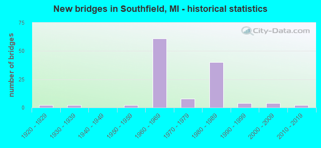
- New bridges - historical statistics
- 21920-1929
- 21930-1939
- 21950-1959
- 611960-1969
- 81970-1979
- 401980-1989
- 41990-1999
- 42000-2009
- 22010-2019
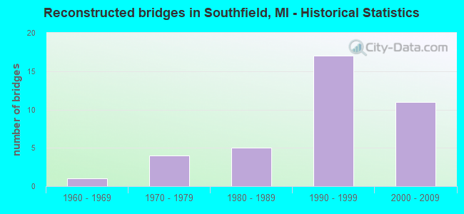
- Reconstructed bridges - Historical Statistics
- 11960-1969
- 41970-1979
- 51980-1989
- 171990-1999
- 112000-2009
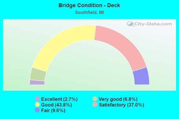
- Bridge Condition - Deck
- 2.7%Excellent
- 6.8%Very good
- 43.8%Good
- 37.0%Satisfactory
- 9.6%Fair
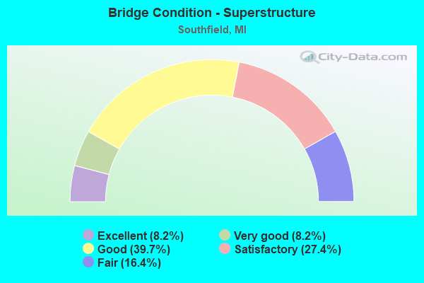
- Bridge Condition - Superstructure
- 8.2%Excellent
- 8.2%Very good
- 39.7%Good
- 27.4%Satisfactory
- 16.4%Fair
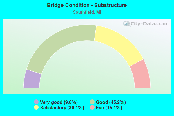
- Bridge Condition - Substructure
- 9.6%Very good
- 45.2%Good
- 30.1%Satisfactory
- 15.1%Fair
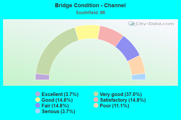
- Bridge Condition - Channel
- 3.7%Excellent
- 37.0%Very good
- 14.8%Good
- 14.8%Satisfactory
- 14.8%Fair
- 11.1%Poor
- 3.7%Serious
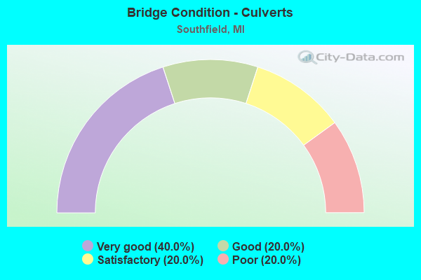
- Bridge Condition - Culverts
- 40.0%Very good
- 20.0%Good
- 20.0%Satisfactory
- 20.0%Poor
Find on map >> Show street view
Structure Number: 788, Location: 0.8 MI NE OF NEW BUFFALO (Lat: 41.801181, Lng: -86.704569), Route carried "on" structure: Interstate 94, Year Built: 1960, Year Reconstructed: 1998, Status: Open, Structure Length: 4.77m (15.65ft), Average Daily Traffic: 18,879 (year 2007), Truck Traffic: 31%, Average Future Daily Traffic: 25,386 (year 2018), Design Load: HS 25 or greater, Features Intersected: AMTRAK
Minimum Vertical Clearance: 30.48m (100.00ft), Kilometerpoint: 6.029, Lanes on structure: 4, Base Highway Network: Yes (Inventory Route: 136, Subroute: 4), Owner: State Highway Agency, Approaching Roadway Width: 16.5m (54.1ft), Skew: 1 degrees, Material/Design: Steel, Design/Construction: Stringer/Multi-beam, Number Of Spans In Main Unit: 3, Length of Maximum Span: 17.2m (56.4ft), Curb-To-Curb Width: 21.3m (69.9ft), Out-to-Out Width: 22.4m (73.5ft)
Condition: Deck: Good, Superstructure: Fair, Substructure: Satisfactory, Operating Rating: 78.7 metric tons, Method Used To Determine Operating Rating: Load Factor (LF) rating reported by rating factor (RF) method using MS18 loading, Inventory Rating: 47.0 metric tons, Method Used To Determine Inventory Rating: Load Factor (LF) rating reported by rating factor (RF) method using MS18 loading, Structural Evaluation: Somewhat better than minimum adequacy, Deck Geometry: Better than present minimum criteria, Approach Roadway Alignment: Better than present minimum criteria, Designated Inspection Frequency: Every 24 months, Inspection Date: July 2020, Deck Structure Type: Concrete Cast-file-Place, Wearing Surface/Protective System: Wearing Surface: Epoxy Overlay, Deck Protection: Epoxy Coated Reinforcing
Find on map >> Show street view
Structure Number: 789, Location: 0.8 MI NE OF NEW BUFFALO (Lat: 41.801586, Lng: -86.706333), Route carried "on" structure: Interstate 94, Year Built: 1960, Year Reconstructed: 1998, Status: Open, Structure Length: 4.77m (15.65ft), Average Daily Traffic: 18,879 (year 2007), Truck Traffic: 31%, Average Future Daily Traffic: 25,386 (year 2018), Design Load: HS 25 or greater, Features Intersected: AMTRAK
Minimum Vertical Clearance: 30.48m (100.00ft), Kilometerpoint: 6.000, Lanes on structure: 4, Base Highway Network: Yes (Inventory Route: 136, Subroute: 2), Owner: State Highway Agency, Approaching Roadway Width: 17.1m (56.1ft), Skew: 1 degrees, Material/Design: Steel, Design/Construction: Stringer/Multi-beam, Number Of Spans In Main Unit: 3, Length of Maximum Span: 17.2m (56.4ft), Curb-To-Curb Width: 21.0m (68.9ft), Out-to-Out Width: 21.8m (71.5ft)
Condition: Deck: Satisfactory, Superstructure: Fair, Substructure: Fair, Operating Rating: 87.5 metric tons, Method Used To Determine Operating Rating: Load Factor (LF) rating reported by rating factor (RF) method using MS18 loading, Inventory Rating: 52.5 metric tons, Method Used To Determine Inventory Rating: Load Factor (LF) rating reported by rating factor (RF) method using MS18 loading, Structural Evaluation: Somewhat better than minimum adequacy, Deck Geometry: Better than present minimum criteria, Approach Roadway Alignment: Equal to present desirable criteria, Designated Inspection Frequency: Every 24 months, Inspection Date: July 2020, Deck Structure Type: Concrete Cast-file-Place, Wearing Surface/Protective System: Wearing Surface: Epoxy Overlay, Deck Protection: Epoxy Coated Reinforcing
Find on map >> Show street view
Structure Number: 792, Location: 0.2 MI N OF BRIDGEMAN (Lat: 41.952311, Lng: -86.560903), Route carried "on" structure: Interstate 94, Year Built: 1961, Year Reconstructed: 1979, Status: Open, Structure Length: 0.94m (3.08ft), Average Daily Traffic: 22,675 (year 2015), Truck Traffic: 30%, Average Future Daily Traffic: 26,325 (year 2035), Design Load: HS 20, Features Intersected: CSX RR SPUR (ABN)
Minimum Vertical Clearance: 30.48m (100.00ft), Kilometerpoint: 27.712, Lanes on structure: 3, Base Highway Network: Yes (Inventory Route: 136, Subroute: 4), Owner: State Highway Agency, Approaching Roadway Width: 18.0m (59.1ft), Material/Design: Prestressed concrete, Design/Construction: Stringer/Multi-beam, Number Of Spans In Main Unit: 1, Length of Maximum Span: 9.4m (30.8ft), Curb-To-Curb Width: 18.0m (59.1ft), Out-to-Out Width: 18.8m (61.7ft)
Condition: Deck: Satisfactory, Superstructure: Good, Substructure: Good, Operating Rating: 54.1 metric tons, Method Used To Determine Operating Rating: Load Factor (LF) rating reported by rating factor (RF) method using MS18 loading, Inventory Rating: 32.4 metric tons, Method Used To Determine Inventory Rating: Load Factor (LF) rating reported by rating factor (RF) method using MS18 loading, Structural Evaluation: Better than present minimum criteria, Deck Geometry: Better than present minimum criteria, Approach Roadway Alignment: Equal to present desirable criteria, Length Of Structure Improvement: 0.95m (3.12ft), Designated Inspection Frequency: Every 24 months, Inspection Date: August 2020, Bridge Improvement Cost: $58,000, Roadway Improvement Cost: $6,000, Total Project Cost: $65,000, Deck Structure Type: Concrete Cast-file-Place, Wearing Surface/Protective System: Wearing Surface: Latex Concrete, Deck Protection: Epoxy Coated Reinforcing
Find on map >> Show street view
Structure Number: 793, Location: 0.2 MI N OF BRIDGEMAN (Lat: 41.952408, Lng: -86.561192), Route carried "on" structure: Interstate 94, Year Built: 1961, Year Reconstructed: 1979, Status: Open, Structure Length: 0.94m (3.08ft), Average Daily Traffic: 22,675 (year 2015), Truck Traffic: 30%, Average Future Daily Traffic: 26,325 (year 2035), Design Load: HS 20, Features Intersected: CSX RR SPUR (ABN)
Minimum Vertical Clearance: 30.48m (100.00ft), Kilometerpoint: 27.720, Lanes on structure: 3, Base Highway Network: Yes (Inventory Route: 136, Subroute: 2), Owner: State Highway Agency, Approaching Roadway Width: 18.0m (59.1ft), Material/Design: Prestressed concrete, Design/Construction: Stringer/Multi-beam, Number Of Spans In Main Unit: 1, Length of Maximum Span: 9.4m (30.8ft), Curb-To-Curb Width: 18.0m (59.1ft), Out-to-Out Width: 18.8m (61.7ft)
Condition: Deck: Good, Superstructure: Good, Substructure: Good, Operating Rating: 54.4 metric tons, Method Used To Determine Operating Rating: Load Factor (LF) rating reported by rating factor (RF) method using MS18 loading, Inventory Rating: 32.4 metric tons, Method Used To Determine Inventory Rating: Load Factor (LF) rating reported by rating factor (RF) method using MS18 loading, Structural Evaluation: Better than present minimum criteria, Deck Geometry: Better than present minimum criteria, Approach Roadway Alignment: Equal to present desirable criteria, Length Of Structure Improvement: 0.95m (3.12ft), Designated Inspection Frequency: Every 24 months, Inspection Date: August 2020, Bridge Improvement Cost: $58,000, Roadway Improvement Cost: $6,000, Total Project Cost: $65,000, Deck Structure Type: Concrete Cast-file-Place, Wearing Surface/Protective System: Wearing Surface: Latex Concrete, Deck Protection: Epoxy Coated Reinforcing
Find on map >> Show street view
Structure Number: 795, Location: 1.0 MI N OF STEVENSVILLE (Lat: 42.033217, Lng: -86.510828), Route carried "on" structure: Interstate 94, Year Built: 1960, Year Reconstructed: 1999, Status: Open, Structure Length: 5.97m (19.59ft), Average Daily Traffic: 22,145 (year 2007), Truck Traffic: 28%, Average Future Daily Traffic: 31,354 (year 2018), Design Load: HS 20, Features Intersected: CSX RR
Minimum Vertical Clearance: 30.48m (100.00ft), Kilometerpoint: 38.006, Lanes on structure: 3, Base Highway Network: Yes (Inventory Route: 136, Subroute: 2), Owner: State Highway Agency, Approaching Roadway Width: 17.7m (58.1ft), Skew: 4 degrees, Material/Design: Steel, Design/Construction: Stringer/Multi-beam, Number Of Spans In Main Unit: 3, Length of Maximum Span: 19.8m (65.0ft), Curb-To-Curb Width: 14.3m (46.9ft), Out-to-Out Width: 17.7m (58.1ft)
Condition: Deck: Satisfactory, Superstructure: Fair, Substructure: Satisfactory, Operating Rating: 74.0 metric tons, Method Used To Determine Operating Rating: Load Factor (LF), Inventory Rating: 44.4 metric tons, Method Used To Determine Inventory Rating: Load Factor (LF), Structural Evaluation: Somewhat better than minimum adequacy, Deck Geometry: Meets minimum limits, Underclear: Better than present minimum criteria, Approach Roadway Alignment: Equal to present desirable criteria, Designated Inspection Frequency: Every 24 months, Inspection Date: August 2020, Deck Structure Type: Concrete Cast-file-Place, Wearing Surface/Protective System: Wearing Surface: Latex Concrete
Find on map >> Show street view
Structure Number: 817, Location: N LTS OF STEVENSVILLE (Lat: 42.023439, Lng: -86.528644), Route carried "on" structure: Interstate 94, Year Built: 1961, Year Reconstructed: 1997, Status: Open, Structure Length: 4.71m (15.45ft), Average Daily Traffic: 22,675 (year 2015), Truck Traffic: 30%, Average Future Daily Traffic: 26,325 (year 2035), Design Load: HS 20+Mod, Features Intersected: PUETZ RD
Minimum Vertical Clearance: 30.48m (100.00ft), Kilometerpoint: 36.173, Lanes on structure: 3, Lanes under structure: 2, Base Highway Network: Yes (Inventory Route: 136, Subroute: 2), Owner: State Highway Agency, Approaching Roadway Width: 18.7m (61.4ft), Skew: 3 degrees, Material/Design: Steel, Design/Construction: Stringer/Multi-beam, Number Of Spans In Main Unit: 3, Length of Maximum Span: 16.7m (54.8ft), Curb-To-Curb Width: 17.1m (56.1ft), Out-to-Out Width: 17.9m (58.7ft)
Condition: Deck: Satisfactory, Superstructure: Fair, Substructure: Good, Operating Rating: 74.2 metric tons, Method Used To Determine Operating Rating: Load Factor (LF) rating reported by rating factor (RF) method using MS18 loading, Inventory Rating: 44.4 metric tons, Method Used To Determine Inventory Rating: Load Factor (LF) rating reported by rating factor (RF) method using MS18 loading, Structural Evaluation: Somewhat better than minimum adequacy, Deck Geometry: Equal to present minimum criteria, Underclear: Somewhat better than minimum adequacy, Approach Roadway Alignment: Equal to present desirable criteria, Designated Inspection Frequency: Every 24 months, Inspection Date: May 2020, Deck Structure Type: Concrete Cast-file-Place, Wearing Surface/Protective System: Wearing Surface: Latex Concrete, Deck Protection: Epoxy Coated Reinforcing
Find on map >> Show street view
Structure Number: 829, Location: 3.0 MI E OF BENTON HARBOR (Lat: 42.127183, Lng: -86.378894), Route carried "on" structure: Interstate 94, Year Built: 1960, Status: Open, Structure Length: 0.94m (3.08ft), Average Daily Traffic: 56,570 (year 2007), Truck Traffic: 26%, Average Future Daily Traffic: 71,820 (year 2018), Design Load: HS 20+Mod, Features Intersected: BLUE CREEK
Minimum Vertical Clearance: 30.48m (100.00ft), Kilometerpoint: 53.778, Lanes on structure: 6, Base Highway Network: Yes (Inventory Route: 136, Subroute: 4), Owner: State Highway Agency, Approaching Roadway Width: 33.8m (110.9ft), Skew: 21 degrees, Material/Design: Concrete, Design/Construction: Tee Beam, Number Of Spans In Main Unit: 1, Length of Maximum Span: 9.4m (30.8ft), Curb-To-Curb Width: 42.1m (138.1ft), Out-to-Out Width: 48.6m (159.4ft)
Condition: Deck: Satisfactory, Superstructure: Satisfactory, Substructure: Good, Operating Rating: 63.5 metric tons, Method Used To Determine Operating Rating: Load Factor (LF) rating reported by rating factor (RF) method using MS18 loading, Inventory Rating: 38.6 metric tons, Method Used To Determine Inventory Rating: Load Factor (LF) rating reported by rating factor (RF) method using MS18 loading, Structural Evaluation: Equal to present minimum criteria, Deck Geometry: Superior to present desirable criteria, Waterway Adequacy: Better than present minimum criteria, Approach Roadway Alignment: Equal to present desirable criteria, Designated Inspection Frequency: Every 24 months, Inspection Date: June 2020, Deck Structure Type: Concrete Cast-file-Place, Wearing Surface/Protective System: Wearing Surface: Bituminous, Membrane: Other
Find on map >> Show street view
Structure Number: 7811, Location: IN SOUTHFIELD (Lat: 42.477139, Lng: -83.284475), Route carried "on" structure: US 24, Year Built: 1953, Year Reconstructed: 1999, Status: Open, Structure Length: 3.66m (12.01ft), Average Daily Traffic: 39,209 (year 2007), Truck Traffic: 2%, Average Future Daily Traffic: 44,753 (year 2018), Design Load: HS 25 or greater, Features Intersected: ROUGE RIVER
Minimum Vertical Clearance: 30.48m (100.00ft), Kilometerpoint: 3.917, Lanes on structure: 4, Base Highway Network: Yes (Inventory Route: 71, Subroute: 6), Owner: State Highway Agency, Approaching Roadway Width: 14.6m (47.9ft), Material/Design: Prestressed concrete, Design/Construction: Stringer/Multi-beam, Number Of Spans In Main Unit: 3, Length of Maximum Span: 12.2m (40.0ft), Curb-To-Curb Width: 17.0m (55.8ft), Out-to-Out Width: 18.1m (59.4ft)
Condition: Deck: Good, Superstructure: Very good, Substructure: Fair, Channel: Very good, Operating Rating: 68.0 metric tons, Method Used To Determine Operating Rating: Load Factor (LF) rating reported by rating factor (RF) method using MS18 loading, Inventory Rating: 40.8 metric tons, Method Used To Determine Inventory Rating: Load Factor (LF) rating reported by rating factor (RF) method using MS18 loading, Structural Evaluation: Somewhat better than minimum adequacy, Deck Geometry: Somewhat better than minimum adequacy, Waterway Adequacy: Equal to present desirable criteria, Approach Roadway Alignment: Equal to present desirable criteria, Designated Inspection Frequency: Every 24 months, Other Special Inspection Frequency: Every 24 months, Inspection Date: December 2020, Other Special Inspection Date: December 2021, Deck Structure Type: Concrete Cast-file-Place, Wearing Surface/Protective System: Wearing Surface: Monolithic Concrete, Deck Protection: Epoxy Coated Reinforcing
Find on map >> Show street view
Structure Number: 7813, Location: IN SOUTHFIELD (Lat: 42.477033, Lng: -83.284867), Route carried "on" structure: US 24, Year Built: 1966, Year Reconstructed: 1999, Status: Open, Structure Length: 3.66m (12.01ft), Average Daily Traffic: 39,209 (year 2007), Truck Traffic: 2%, Average Future Daily Traffic: 44,753 (year 2018), Design Load: HS 25 or greater, Features Intersected: ROUGE RIVER
Minimum Vertical Clearance: 30.48m (100.00ft), Kilometerpoint: 3.904, Lanes on structure: 4, Base Highway Network: Yes (Inventory Route: 71, Subroute: 9), Owner: State Highway Agency, Approaching Roadway Width: 15.8m (51.8ft), Skew: 30 degrees, Material/Design: Steel, Design/Construction: Stringer/Multi-beam, Number Of Spans In Main Unit: 3, Length of Maximum Span: 12.2m (40.0ft), Curb-To-Curb Width: 16.8m (55.1ft), Out-to-Out Width: 17.8m (58.4ft)
Condition: Deck: Good, Superstructure: Fair, Substructure: Satisfactory, Channel: Good, Operating Rating: 80.4 metric tons, Method Used To Determine Operating Rating: Load Factor (LF) rating reported by rating factor (RF) method using MS18 loading, Inventory Rating: 48.0 metric tons, Method Used To Determine Inventory Rating: Load Factor (LF) rating reported by rating factor (RF) method using MS18 loading, Structural Evaluation: Somewhat better than minimum adequacy, Deck Geometry: Somewhat better than minimum adequacy, Waterway Adequacy: Equal to present desirable criteria, Approach Roadway Alignment: Better than present minimum criteria, Designated Inspection Frequency: Every 24 months, Inspection Date: December 2020, Deck Structure Type: Concrete Cast-file-Place, Wearing Surface/Protective System: Wearing Surface: Monolithic Concrete, Deck Protection: Epoxy Coated Reinforcing
Find on map >> Show street view
Structure Number: 787, Location: IN SOUTHFIELD (Lat: 42.486689, Lng: -83.280392), Route carried "on" structure: State highway 10, Year Built: 1964, Year Reconstructed: 2006, Status: Open, Structure Length: 4.84m (15.88ft), Average Daily Traffic: 69,850 (year 2007), Truck Traffic: 1%, Average Future Daily Traffic: 75,000 (year 2018), Design Load: HS 20+Mod, Features Intersected: ROUGE RIVER
Minimum Vertical Clearance: 30.48m (100.00ft), Kilometerpoint: 8.131, Lanes on structure: 5, Base Highway Network: Yes (Inventory Route: 71, Subroute: 10), Owner: State Highway Agency, Approaching Roadway Width: 19.5m (64.0ft), Material/Design: Prestressed concrete, Design/Construction: Stringer/Multi-beam, Number Of Spans In Main Unit: 3, Length of Maximum Span: 18.9m (62.0ft), Curb-To-Curb Width: 25.0m (82.0ft), Out-to-Out Width: 26.0m (85.3ft)
Condition: Deck: Good, Superstructure: Satisfactory, Substructure: Fair, Channel: Good, Operating Rating: 68.7 metric tons, Method Used To Determine Operating Rating: Load Factor (LF) rating reported by rating factor (RF) method using MS18 loading, Inventory Rating: 38.6 metric tons, Method Used To Determine Inventory Rating: Load Factor (LF) rating reported by rating factor (RF) method using MS18 loading, Structural Evaluation: Somewhat better than minimum adequacy, Deck Geometry: Better than present minimum criteria, Waterway Adequacy: Equal to present desirable criteria, Approach Roadway Alignment: Better than present minimum criteria, Designated Inspection Frequency: Every 24 months, Inspection Date: May 2021, Deck Structure Type: Concrete Cast-file-Place, Wearing Surface/Protective System: Wearing Surface: Monolithic Concrete, Deck Protection: Epoxy Coated Reinforcing
Find on map >> Show street view
Structure Number: 7871, Location: IN SOUTHFIELD (Lat: 42.488572, Lng: -83.276703), Route carried "on" structure: State highway 10, Year Built: 1929, Year Reconstructed: 1969, Status: Open, Structure Length: 1.82m (5.97ft), Average Daily Traffic: 69,850 (year 2007), Truck Traffic: 1%, Average Future Daily Traffic: 75,000 (year 2018), Design Load: H 20, Features Intersected: ROUGE RIVER
Minimum Vertical Clearance: 30.48m (100.00ft), Kilometerpoint: 8.279, Lanes on structure: 6, Base Highway Network: Yes (Inventory Route: 71, Subroute: 2), Owner: State Highway Agency, Approaching Roadway Width: 27.4m (89.9ft), Material/Design: Steel, Design/Construction: Stringer/Multi-beam, Number Of Spans In Main Unit: 1, Length of Maximum Span: 18.2m (59.7ft), Curb-To-Curb Width: 26.1m (85.6ft), Out-to-Out Width: 27.6m (90.6ft)
Condition: Deck: Fair, Superstructure: Satisfactory, Substructure: Fair, Channel: Satisfactory, Operating Rating: 74.8 metric tons, Method Used To Determine Operating Rating: Load Factor (LF) rating reported by rating factor (RF) method using MS18 loading, Inventory Rating: 44.7 metric tons, Method Used To Determine Inventory Rating: Load Factor (LF) rating reported by rating factor (RF) method using MS18 loading, Structural Evaluation: Somewhat better than minimum adequacy, Deck Geometry: Meets minimum limits, Waterway Adequacy: Equal to present desirable criteria, Approach Roadway Alignment: Better than present minimum criteria, Designated Inspection Frequency: Every 24 months, Inspection Date: May 2021, Deck Structure Type: Concrete Cast-file-Place, Wearing Surface/Protective System: Wearing Surface: Latex Concrete
Find on map >> Show street view
Structure Number: 7872, Location: 0.75 MILES N OF M-102 (Lat: 42.451678, Lng: -83.211083), Route carried "on" structure: City street , Year Built: 1964, Year Reconstructed: 1997, Status: Open, Structure Length: 3.50m (11.48ft), Average Daily Traffic: 9,000 (year 1995), Truck Traffic: 7%, Average Future Daily Traffic: 14,000 (year 2015), Design Load: H 20, Features Intersected: M-10, Facility Carried by Structure: J L HUDSON DRIVE
Minimum Vertical Clearance: 30.48m (100.00ft), Kilometerpoint: 0.023, Lanes on structure: 4, Lanes under structure: 6, Owner: State Highway Agency, Approaching Roadway Width: 17.0m (55.8ft), Skew: 20 degrees, Material/Design: Steel, Design/Construction: Stringer/Multi-beam, Number Of Spans In Main Unit: 2, Length of Maximum Span: 18.2m (59.7ft), Curb-To-Curb Width: 17.6m (57.7ft), Out-to-Out Width: 21.7m (71.2ft)
Condition: Deck: Good, Superstructure: Satisfactory, Substructure: Good, Operating Rating: 75.8 metric tons, Method Used To Determine Operating Rating: Load Factor (LF) rating reported by rating factor (RF) method using MS18 loading, Inventory Rating: 45.4 metric tons, Method Used To Determine Inventory Rating: Load Factor (LF) rating reported by rating factor (RF) method using MS18 loading, Structural Evaluation: Equal to present minimum criteria, Deck Geometry: Somewhat better than minimum adequacy, Underclear: High priority of corrective action, Approach Roadway Alignment: Equal to present desirable criteria, Designated Inspection Frequency: Every 24 months, Inspection Date: September 2020, Deck Structure Type: Concrete Cast-file-Place, Wearing Surface/Protective System: Wearing Surface: Monolithic Concrete, Deck Protection: Epoxy Coated Reinforcing
Find on map >> Show street view
Structure Number: 7873, Location: IN SOUTHFIELD (RAMP G) (Lat: 42.456264, Lng: -83.218608), Route carried "on" structure: Ramp State highway 39, Year Built: 1964, Year Reconstructed: 2006, Status: Open, Structure Length: 4.93m (16.17ft), Average Daily Traffic: 67,700 (year 1987), Truck Traffic: 6%, Average Future Daily Traffic: 67,700 (year 2007), Design Load: HS 20, Features Intersected: M-10 WB (RAMP G)
Minimum Vertical Clearance: 30.48m (100.00ft), Kilometerpoint: 0.328, Lanes on structure: 3, Lanes under structure: 1, Owner: State Highway Agency, Approaching Roadway Width: 12.2m (40.0ft), Skew: 4 degrees, Material/Design: Steel, Design/Construction: Stringer/Multi-beam, Number Of Spans In Main Unit: 3, Length of Maximum Span: 20.3m (66.6ft), Curb-To-Curb Width: 13.1m (43.0ft), Out-to-Out Width: 14.3m (46.9ft)
Condition: Deck: Fair, Superstructure: Fair, Substructure: Satisfactory, Operating Rating: 70.0 metric tons, Method Used To Determine Operating Rating: Load Factor (LF) rating reported by rating factor (RF) method using MS18 loading, Inventory Rating: 41.8 metric tons, Method Used To Determine Inventory Rating: Load Factor (LF) rating reported by rating factor (RF) method using MS18 loading, Structural Evaluation: Somewhat better than minimum adequacy, Deck Geometry: Somewhat better than minimum adequacy, Underclear: Better than present minimum criteria, Approach Roadway Alignment: Equal to present desirable criteria, Designated Inspection Frequency: Every 24 months, Inspection Date: June 2021, Deck Structure Type: Concrete Cast-file-Place, Wearing Surface/Protective System: Wearing Surface: Latex Concrete
Find on map >> Show street view
Structure Number: 7874, Location: IN SOUTHFIELD (RAMP A) (Lat: 42.456961, Lng: -83.217878), Route carried "on" structure: Ramp State highway 10, Year Built: 1964, Year Reconstructed: 2006, Status: Open, Structure Length: 5.97m (19.59ft), Average Daily Traffic: 67,700 (year 1987), Truck Traffic: 6%, Average Future Daily Traffic: 77,855 (year 2007), Design Load: HS 20, Features Intersected: M-10 RAMP
Minimum Vertical Clearance: 30.48m (100.00ft), Kilometerpoint: 0.267, Lanes on structure: 2, Lanes under structure: 1, Owner: State Highway Agency, Approaching Roadway Width: 9.7m (31.8ft), Skew: 6 degrees, Material/Design: Steel, Design/Construction: Stringer/Multi-beam, Number Of Spans In Main Unit: 3, Length of Maximum Span: 23.5m (77.1ft), Curb-To-Curb Width: 9.4m (30.8ft), Out-to-Out Width: 10.6m (34.8ft)
Condition: Deck: Satisfactory, Superstructure: Good, Substructure: Satisfactory, Operating Rating: 80.4 metric tons, Method Used To Determine Operating Rating: Load Factor (LF) rating reported by rating factor (RF) method using MS18 loading, Inventory Rating: 48.0 metric tons, Method Used To Determine Inventory Rating: Load Factor (LF) rating reported by rating factor (RF) method using MS18 loading, Structural Evaluation: Equal to present minimum criteria, Deck Geometry: Somewhat better than minimum adequacy, Underclear: Meets minimum limits, Approach Roadway Alignment: Equal to present desirable criteria, Designated Inspection Frequency: Every 24 months, Inspection Date: September 2020, Deck Structure Type: Concrete Cast-file-Place, Wearing Surface/Protective System: Wearing Surface: Latex Concrete
Find on map >> Show street view
Structure Number: 7875, Location: IN SOUTHFIELD RAMP H (Lat: 42.456683, Lng: -83.219650), Route carried "on" structure: Ramp State highway 10, Year Built: 1964, Year Reconstructed: 2006, Status: Open, Structure Length: 3.71m (12.17ft), Average Daily Traffic: 10,200 (year 1988), Truck Traffic: 2%, Average Future Daily Traffic: 6,300 (year 2027), Design Load: HS 20, Features Intersected: M-39
Minimum Vertical Clearance: 30.48m (100.00ft), Kilometerpoint: 0.230, Lanes on structure: 2, Lanes under structure: 3, Owner: State Highway Agency, Approaching Roadway Width: 9.8m (32.2ft), Skew: 1 degrees, Material/Design: Steel, Design/Construction: Stringer/Multi-beam, Number Of Spans In Main Unit: 3, Length of Maximum Span: 17.2m (56.4ft), Curb-To-Curb Width: 9.8m (32.2ft), Out-to-Out Width: 10.7m (35.1ft)
Condition: Deck: Satisfactory, Superstructure: Good, Substructure: Satisfactory, Operating Rating: 88.0 metric tons, Method Used To Determine Operating Rating: Load Factor (LF), Inventory Rating: 52.8 metric tons, Method Used To Determine Inventory Rating: Load Factor (LF), Structural Evaluation: Equal to present minimum criteria, Deck Geometry: Equal to present minimum criteria, Underclear: High priority of corrective action, Approach Roadway Alignment: Equal to present desirable criteria, Length Of Structure Improvement: 3.72m (12.20ft), Designated Inspection Frequency: Every 24 months, Inspection Date: June 2021, Bridge Improvement Cost: $49,000, Roadway Improvement Cost: $4,000, Total Project Cost: $50,000, Deck Structure Type: Concrete Cast-file-Place, Wearing Surface/Protective System: Wearing Surface: Monolithic Concrete, Deck Protection: Epoxy Coated Reinforcing
Find on map >> Show street view
Structure Number: 7876, Location: IN SOUTHFIELD (Lat: 42.457667, Lng: -83.219411), Route carried "on" structure: State highway 39, Year Built: 1964, Year Reconstructed: 2006, Status: Open, Structure Length: 8.32m (27.30ft), Average Daily Traffic: 45,241 (year 2007), Truck Traffic: 2%, Average Future Daily Traffic: 56,700 (year 2027), Design Load: HS 20, Features Intersected: M-10
Minimum Vertical Clearance: 30.48m (100.00ft), Kilometerpoint: 1.477, Lanes on structure: 3, Lanes under structure: 6, Base Highway Network: Yes (Inventory Route: 71, Subroute: 3), Owner: State Highway Agency, Approaching Roadway Width: 15.8m (51.8ft), Skew: 3 degrees, Material/Design: Steel, Design/Construction: Stringer/Multi-beam, Number Of Spans In Main Unit: 4, Length of Maximum Span: 29.7m (97.4ft), Curb-To-Curb Width: 13.4m (44.0ft), Out-to-Out Width: 14.4m (47.2ft)
Condition: Deck: Good, Superstructure: Good, Substructure: Good, Operating Rating: 86.2 metric tons, Method Used To Determine Operating Rating: Load Factor (LF) rating reported by rating factor (RF) method using MS18 loading, Inventory Rating: 51.5 metric tons, Method Used To Determine Inventory Rating: Load Factor (LF) rating reported by rating factor (RF) method using MS18 loading, Structural Evaluation: Better than present minimum criteria, Deck Geometry: Meets minimum limits, Underclear: High priority of corrective action, Approach Roadway Alignment: Equal to present desirable criteria, Designated Inspection Frequency: Every 24 months, Inspection Date: June 2021, Deck Structure Type: Concrete Cast-file-Place, Wearing Surface/Protective System: Wearing Surface: Monolithic Concrete, Deck Protection: Epoxy Coated Reinforcing
Find on map >> Show street view
Structure Number: 7877, Location: IN SOUTHFIELD (Lat: 42.458878, Lng: -83.219600), Route carried "on" structure: State highway 39, Year Built: 1998, Status: Open, Structure Length: 4.18m (13.71ft), Average Daily Traffic: 45,241 (year 2007), Truck Traffic: 5%, Average Future Daily Traffic: 52,851 (year 2018), Design Load: HS 25 or greater, Features Intersected: 9 MILE RD
Minimum Vertical Clearance: 30.48m (100.00ft), Kilometerpoint: 1.640, Lanes on structure: 5, Lanes under structure: 4, Base Highway Network: Yes (Inventory Route: 71, Subroute: 3), Owner: State Highway Agency, Approaching Roadway Width: 23.7m (77.8ft), Skew: 2 degrees, Material/Design: Prestressed concrete, Design/Construction: Box Beam or Girders - Single/Spread, Number Of Spans In Main Unit: 3, Length of Maximum Span: 23.0m (75.5ft), Curb-To-Curb Width: 25.7m (84.3ft), Out-to-Out Width: 27.3m (89.6ft)
Condition: Deck: Good, Superstructure: Good, Substructure: Good, Operating Rating: 63.8 metric tons, Method Used To Determine Operating Rating: Load Factor (LF) rating reported by rating factor (RF) method using MS18 loading, Inventory Rating: 30.8 metric tons, Method Used To Determine Inventory Rating: Load Factor (LF) rating reported by rating factor (RF) method using MS18 loading, Structural Evaluation: Better than present minimum criteria, Deck Geometry: Better than present minimum criteria, Underclear: Meets minimum limits, Approach Roadway Alignment: Equal to present desirable criteria, Designated Inspection Frequency: Every 24 months, Inspection Date: September 2020, Deck Structure Type: Concrete Cast-file-Place, Wearing Surface/Protective System: Wearing Surface: Monolithic Concrete, Deck Protection: Epoxy Coated Reinforcing
Find on map >> Show street view
Structure Number: 7878, Location: IN SOUTHFIELD (RAMP E) (Lat: 42.458792, Lng: -83.222278), Route carried "on" structure: City street 2059, Year Built: 1964, Year Reconstructed: 1998, Status: Open, Structure Length: 3.60m (11.81ft), Average Daily Traffic: 16,620 (year 1997), Truck Traffic: 3%, Average Future Daily Traffic: 17,540 (year 2015), Design Load: HS 20, Features Intersected: M-10 RAMP, Facility Carried by Structure: 9 MI RD
Minimum Vertical Clearance: 30.48m (100.00ft), Kilometerpoint: 7.843, Lanes on structure: 5, Lanes under structure: 2, Owner: State Highway Agency, Approaching Roadway Width: 17.7m (58.1ft), Skew: 2 degrees, Material/Design: Steel, Design/Construction: Stringer/Multi-beam, Number Of Spans In Main Unit: 3, Length of Maximum Span: 14.3m (46.9ft), Curb or Sidewalk Widths: Left: 0.0m, Right: 1.2m (3.9ft), Curb-To-Curb Width: 17.1m (56.1ft), Out-to-Out Width: 19.5m (64.0ft)
Condition: Deck: Good, Superstructure: Good, Substructure: Satisfactory, Operating Rating: 71.9 metric tons, Method Used To Determine Operating Rating: Load Factor (LF) rating reported by rating factor (RF) method using MS18 loading, Inventory Rating: 43.1 metric tons, Method Used To Determine Inventory Rating: Load Factor (LF) rating reported by rating factor (RF) method using MS18 loading, Structural Evaluation: Equal to present minimum criteria, Deck Geometry: High priority of replacement, Underclear: High priority of corrective action, Approach Roadway Alignment: Equal to present desirable criteria, Designated Inspection Frequency: Every 24 months, Inspection Date: October 2021, Deck Structure Type: Concrete Cast-file-Place, Wearing Surface/Protective System: Wearing Surface: Monolithic Concrete, Deck Protection: Epoxy Coated Reinforcing
Find on map >> Show street view
Structure Number: 7879, Location: SOUTHFIELD (M-39 SB & US (Lat: 42.458825, Lng: -83.221217), Route carried "on" structure: City street 2059, Year Built: 1964, Year Reconstructed: 1998, Status: Open, Structure Length: 7.65m (25.10ft), Average Daily Traffic: 16,620 (year 1997), Truck Traffic: 3%, Average Future Daily Traffic: 17,540 (year 2015), Design Load: HS 20, Features Intersected: M-10, Facility Carried by Structure: 9 MI RD
Minimum Vertical Clearance: 4.41m (14.47ft), Kilometerpoint: 7.915, Lanes on structure: 5, Lanes under structure: 4, Owner: State Highway Agency, Approaching Roadway Width: 18.3m (60.0ft), Skew: 4 degrees, Material/Design: Steel, Design/Construction: Stringer/Multi-beam, Number Of Spans In Main Unit: 4, Length of Maximum Span: 23.4m (76.8ft), Curb or Sidewalk Widths: Left: 0.0m, Right: 1.2m (3.9ft), Curb-To-Curb Width: 17.1m (56.1ft), Out-to-Out Width: 19.5m (64.0ft)
Condition: Deck: Good, Superstructure: Satisfactory, Substructure: Good, Operating Rating: 82.0 metric tons, Method Used To Determine Operating Rating: Load Factor (LF), Inventory Rating: 49.1 metric tons, Method Used To Determine Inventory Rating: Load Factor (LF), Structural Evaluation: Equal to present minimum criteria, Deck Geometry: High priority of replacement, Underclear: High priority of corrective action, Approach Roadway Alignment: Equal to present desirable criteria, Designated Inspection Frequency: Every 24 months, Inspection Date: October 2021, Deck Structure Type: Concrete Cast-file-Place, Wearing Surface/Protective System: Wearing Surface: Monolithic Concrete, Deck Protection: Epoxy Coated Reinforcing
Find on map >> Show street view
Structure Number: 788, Location: SOUTHFIELD (TOP LEVEL) (Lat: 42.458950, Lng: -83.221397), Route carried "on" structure: State highway 39, Year Built: 1964, Year Reconstructed: 1998, Status: Open, Structure Length: 11.28m (37.01ft), Average Daily Traffic: 45,241 (year 2007), Truck Traffic: 5%, Average Future Daily Traffic: 52,851 (year 2018), Design Load: HS 20, Features Intersected: 9 MILE RD
Minimum Vertical Clearance: 30.48m (100.00ft), Kilometerpoint: 1.653, Lanes on structure: 3, Lanes under structure: 4, Base Highway Network: Yes (Inventory Route: 71, Subroute: 3), Owner: State Highway Agency, Approaching Roadway Width: 12.2m (40.0ft), Skew: 4 degrees, Material/Design: Steel, Design/Construction: Stringer/Multi-beam, Number Of Spans In Main Unit: 3, Length of Maximum Span: 42.6m (139.8ft), Curb-To-Curb Width: 13.0m (42.7ft), Out-to-Out Width: 14.3m (46.9ft)
Condition: Deck: Good, Superstructure: Satisfactory, Substructure: Fair, Operating Rating: 83.6 metric tons, Method Used To Determine Operating Rating: Load Factor (LF) rating reported by rating factor (RF) method using MS18 loading, Inventory Rating: 49.9 metric tons, Method Used To Determine Inventory Rating: Load Factor (LF) rating reported by rating factor (RF) method using MS18 loading, Structural Evaluation: Somewhat better than minimum adequacy, Deck Geometry: Meets minimum limits, Underclear: High priority of corrective action, Approach Roadway Alignment: Better than present minimum criteria, Designated Inspection Frequency: Every 24 months, Inspection Date: October 2021, Deck Structure Type: Concrete Cast-file-Place, Wearing Surface/Protective System: Wearing Surface: Monolithic Concrete, Deck Protection: Epoxy Coated Reinforcing
Find on map >> Show street view
Structure Number: 7881, Location: IN SOUTHFIELD (RAMP C) (Lat: 42.459919, Lng: -83.221272), Route carried "on" structure: State highway 39, Year Built: 1964, Year Reconstructed: 2006, Status: Open, Structure Length: 3.39m (11.12ft), Average Daily Traffic: 45,241 (year 2007), Truck Traffic: 2%, Average Future Daily Traffic: 38,000 (year 2027), Design Load: HS 20, Features Intersected: M-10 RAMP C
Minimum Vertical Clearance: 30.48m (100.00ft), Kilometerpoint: 1.762, Lanes on structure: 3, Lanes under structure: 2, Base Highway Network: Yes (Inventory Route: 71, Subroute: 3), Owner: State Highway Agency, Approaching Roadway Width: 15.2m (49.9ft), Material/Design: Steel, Design/Construction: Stringer/Multi-beam, Number Of Spans In Main Unit: 3, Length of Maximum Span: 13.2m (43.3ft), Curb-To-Curb Width: 13.4m (44.0ft), Out-to-Out Width: 14.4m (47.2ft)
Condition: Deck: Good, Superstructure: Satisfactory, Substructure: Satisfactory, Operating Rating: 86.5 metric tons, Method Used To Determine Operating Rating: Load Factor (LF) rating reported by rating factor (RF) method using MS18 loading, Inventory Rating: 51.8 metric tons, Method Used To Determine Inventory Rating: Load Factor (LF) rating reported by rating factor (RF) method using MS18 loading, Structural Evaluation: Equal to present minimum criteria, Deck Geometry: High priority of replacement, Underclear: Meets minimum limits, Approach Roadway Alignment: Equal to present desirable criteria, Designated Inspection Frequency: Every 24 months, Inspection Date: October 2021, Deck Structure Type: Concrete Cast-file-Place, Wearing Surface/Protective System: Wearing Surface: Monolithic Concrete, Deck Protection: Epoxy Coated Reinforcing
Find on map >> Show street view
Structure Number: 7882, Location: IN SOUTHFIELD (M-10) (Lat: 42.465175, Lng: -83.230672), Route carried "on" structure: City street , Year Built: 1963, Year Reconstructed: 1997, Status: Open, Structure Length: 3.72m (12.20ft), Average Daily Traffic: 5,999 (year 2019), Truck Traffic: 3%, Average Future Daily Traffic: 6,628 (year 2039), Design Load: H 15, Features Intersected: M-10, Facility Carried by Structure: MOUNT VERNON ST
Minimum Vertical Clearance: 30.48m (100.00ft), Kilometerpoint: 0.029, Lanes on structure: 2, Lanes under structure: 6, Owner: State Highway Agency, Approaching Roadway Width: 9.1m (29.9ft), Material/Design: Steel, Design/Construction: Stringer/Multi-beam, Number Of Spans In Main Unit: 2, Length of Maximum Span: 18.6m (61.0ft), Curb or Sidewalk Widths: Left: 1.5m (4.9ft), Right: 1.5m (4.9ft), Curb-To-Curb Width: 7.9m (25.9ft), Out-to-Out Width: 11.7m (38.4ft)
Condition: Deck: Satisfactory, Superstructure: Very good, Substructure: Very good, Operating Rating: 52.5 metric tons, Method Used To Determine Operating Rating: Load Factor (LF) rating reported by rating factor (RF) method using MS18 loading, Inventory Rating: 31.4 metric tons, Method Used To Determine Inventory Rating: Load Factor (LF) rating reported by rating factor (RF) method using MS18 loading, Structural Evaluation: Better than present minimum criteria, Deck Geometry: High priority of replacement, Underclear: High priority of corrective action, Approach Roadway Alignment: Equal to present desirable criteria, Designated Inspection Frequency: Every 18 months, Inspection Date: December 2020, Deck Structure Type: Concrete Cast-file-Place, Wearing Surface/Protective System: Wearing Surface: Latex Concrete
Find on map >> Show street view
Structure Number: 7883, Location: IN SOUTHFIELD (Lat: 42.471775, Lng: -83.240447), Route carried "on" structure: City street 2059, Year Built: 1974, Status: Open, Structure Length: 5.33m (17.49ft), Average Daily Traffic: 11,011 (year 2018), Truck Traffic: 3%, Average Future Daily Traffic: 12,166 (year 2038), Design Load: HS 20, Features Intersected: M-10, Facility Carried by Structure: EVERGREEN RD (NB)
Minimum Vertical Clearance: 30.48m (100.00ft), Kilometerpoint: 3.079, Lanes on structure: 3, Lanes under structure: 6, Owner: State Highway Agency, Approaching Roadway Width: 14.6m (47.9ft), Skew: 4 degrees, Material/Design: Steel, Design/Construction: Stringer/Multi-beam, Number Of Spans In Main Unit: 2, Length of Maximum Span: 26.8m (87.9ft), Curb or Sidewalk Widths: Left: 0.0m, Right: 1.5m (4.9ft), Curb-To-Curb Width: 12.6m (41.3ft), Out-to-Out Width: 14.8m (48.6ft)
Condition: Deck: Satisfactory, Superstructure: Satisfactory, Substructure: Good, Operating Rating: 75.2 metric tons, Method Used To Determine Operating Rating: Load Factor (LF) rating reported by rating factor (RF) method using MS18 loading, Inventory Rating: 45.0 metric tons, Method Used To Determine Inventory Rating: Load Factor (LF) rating reported by rating factor (RF) method using MS18 loading, Structural Evaluation: Equal to present minimum criteria, Deck Geometry: Meets minimum limits, Underclear: High priority of corrective action, Approach Roadway Alignment: Equal to present desirable criteria, Designated Inspection Frequency: Every 18 months, Inspection Date: December 2020, Deck Structure Type: Concrete Cast-file-Place, Wearing Surface/Protective System: Wearing Surface: Latex Concrete
Find on map >> Show street view
Structure Number: 7884, Location: IN SOUTHFIELD (Lat: 42.471556, Lng: -83.240439), Route carried "on" structure: City street 25, Year Built: 1963, Year Reconstructed: 1997, Status: Open, Structure Length: 5.33m (17.49ft), Average Daily Traffic: 11,011 (year 2018), Truck Traffic: 3%, Average Future Daily Traffic: 12,166 (year 2038), Design Load: H 15, Features Intersected: M-10, Facility Carried by Structure: EVERGREEN RD (SB)
Minimum Vertical Clearance: 30.48m (100.00ft), Kilometerpoint: 0.179, Lanes on structure: 3, Lanes under structure: 6, Owner: State Highway Agency, Approaching Roadway Width: 14.6m (47.9ft), Skew: 4 degrees, Material/Design: Steel, Design/Construction: Stringer/Multi-beam, Number Of Spans In Main Unit: 2, Length of Maximum Span: 26.8m (87.9ft), Curb or Sidewalk Widths: Left: 0.0m, Right: 1.5m (4.9ft), Curb-To-Curb Width: 12.6m (41.3ft), Out-to-Out Width: 14.8m (48.6ft)
Condition: Deck: Satisfactory, Superstructure: Good, Substructure: Good, Operating Rating: 71.3 metric tons, Method Used To Determine Operating Rating: Load Factor (LF) rating reported by rating factor (RF) method using MS18 loading, Inventory Rating: 42.8 metric tons, Method Used To Determine Inventory Rating: Load Factor (LF) rating reported by rating factor (RF) method using MS18 loading, Structural Evaluation: Better than present minimum criteria, Deck Geometry: Meets minimum limits, Underclear: Meets minimum limits, Approach Roadway Alignment: Equal to present desirable criteria, Designated Inspection Frequency: Every 18 months, Inspection Date: December 2020, Deck Structure Type: Concrete Cast-file-Place, Wearing Surface/Protective System: Wearing Surface: Latex Concrete
Find on map >> Show street view
Structure Number: 7885, Location: IN SOUTHFIELD (Lat: 42.472861, Lng: -83.241956), Route carried "on" structure: County highway 2059, Year Built: 1963, Year Reconstructed: 1997, Status: Open, Structure Length: 5.09m (16.70ft), Average Daily Traffic: 19,360 (year 2018), Truck Traffic: 3%, Average Future Daily Traffic: 21,391 (year 2038), Design Load: H 15, Features Intersected: M-10, Facility Carried by Structure: 10 MI RD
Minimum Vertical Clearance: 30.48m (100.00ft), Kilometerpoint: 10.899, Lanes on structure: 4, Lanes under structure: 6, Owner: State Highway Agency, Approaching Roadway Width: 14.6m (47.9ft), Skew: 4 degrees, Material/Design: Steel, Design/Construction: Stringer/Multi-beam, Number Of Spans In Main Unit: 2, Length of Maximum Span: 25.5m (83.7ft), Curb or Sidewalk Widths: Left: 1.5m (4.9ft), Right: 1.5m (4.9ft), Curb-To-Curb Width: 14.6m (47.9ft), Out-to-Out Width: 18.4m (60.4ft)
Condition: Deck: Satisfactory, Superstructure: Good, Substructure: Good, Operating Rating: 58.6 metric tons, Method Used To Determine Operating Rating: Load Factor (LF) rating reported by rating factor (RF) method using MS18 loading, Inventory Rating: 31.1 metric tons, Method Used To Determine Inventory Rating: Load Factor (LF) rating reported by rating factor (RF) method using MS18 loading, Structural Evaluation: Better than present minimum criteria, Deck Geometry: High priority of replacement, Underclear: High priority of corrective action, Approach Roadway Alignment: Equal to present desirable criteria, Designated Inspection Frequency: Every 18 months, Inspection Date: December 2020, Deck Structure Type: Concrete Cast-file-Place, Wearing Surface/Protective System: Wearing Surface: Latex Concrete
Find on map >> Show street view
Structure Number: 7886, Location: IN SOUTHFIELD (Lat: 42.479550, Lng: -83.251156), Route carried "on" structure: City street , Year Built: 1989, Status: Open, Structure Length: 5.27m (17.29ft), Average Daily Traffic: 20,700 (year 1988), Average Future Daily Traffic: 20,700 (year 1977), Design Load: HS 20, Features Intersected: M-10, Facility Carried by Structure: 10.5 MI RD
Minimum Vertical Clearance: 30.48m (100.00ft), Kilometerpoint: 2.797, Lanes on structure: 4, Lanes under structure: 6, Owner: State Highway Agency, Approaching Roadway Width: 10.3m (33.8ft), Skew: 4 degrees, Material/Design: Steel, Design/Construction: Stringer/Multi-beam, Number Of Spans In Main Unit: 2, Length of Maximum Span: 26.8m (87.9ft), Curb or Sidewalk Widths: Left: 2.4m (7.9ft), Right: 3.6m (11.8ft), Curb-To-Curb Width: 32.3m (106.0ft), Out-to-Out Width: 39.4m (129.3ft)
Condition: Deck: Good, Superstructure: Satisfactory, Substructure: Satisfactory, Operating Rating: 66.4 metric tons, Method Used To Determine Operating Rating: Load Factor (LF) rating reported by rating factor (RF) method using MS18 loading, Inventory Rating: 39.5 metric tons, Method Used To Determine Inventory Rating: Load Factor (LF) rating reported by rating factor (RF) method using MS18 loading, Structural Evaluation: Equal to present minimum criteria, Deck Geometry: Superior to present desirable criteria, Underclear: High priority of corrective action, Approach Roadway Alignment: Equal to present desirable criteria, Designated Inspection Frequency: Every 24 months, Inspection Date: June 2021, Deck Structure Type: Concrete Cast-file-Place, Wearing Surface/Protective System: Wearing Surface: Monolithic Concrete, Deck Protection: Epoxy Coated Reinforcing
Find on map >> Show street view
Structure Number: 7887, Location: IN SOUTHFIELD (Lat: 42.483483, Lng: -83.261211), Route carried "on" structure: County highway 2059, Year Built: 1963, Year Reconstructed: 1998, Status: Open, Structure Length: 4.14m (13.58ft), Average Daily Traffic: 57,800 (year 1997), Truck Traffic: 8%, Average Future Daily Traffic: 68,000 (year 2020), Design Load: H 15, Features Intersected: M-10, Facility Carried by Structure: LAHSER RD
Minimum Vertical Clearance: 30.48m (100.00ft), Kilometerpoint: 4.452, Lanes on structure: 7, Lanes under structure: 6, Owner: State Highway Agency, Approaching Roadway Width: 26.8m (87.9ft), Skew: 2 degrees, Material/Design: Steel, Design/Construction: Stringer/Multi-beam, Number Of Spans In Main Unit: 2, Length of Maximum Span: 20.7m (67.9ft), Curb or Sidewalk Widths: Left: 1.5m (4.9ft), Right: 1.5m (4.9ft), Curb-To-Curb Width: 26.8m (87.9ft), Out-to-Out Width: 30.6m (100.4ft)
Condition: Deck: Good, Superstructure: Satisfactory, Substructure: Satisfactory, Operating Rating: 56.7 metric tons, Method Used To Determine Operating Rating: Load Factor (LF) rating reported by rating factor (RF) method using MS18 loading, Inventory Rating: 34.0 metric tons, Method Used To Determine Inventory Rating: Load Factor (LF) rating reported by rating factor (RF) method using MS18 loading, Structural Evaluation: Equal to present minimum criteria, Deck Geometry: Somewhat better than minimum adequacy, Underclear: High priority of corrective action, Approach Roadway Alignment: Equal to present desirable criteria, Designated Inspection Frequency: Every 24 months, Inspection Date: June 2021, Deck Structure Type: Concrete Cast-file-Place, Wearing Surface/Protective System: Wearing Surface: Monolithic Concrete, Deck Protection: Epoxy Coated Reinforcing
Find on map >> Show street view
Structure Number: 789, Location: IN SOUTHFIELD (Lat: 42.453000, Lng: -83.213028), Route carried "on" structure: ServiceCity street , Year Built: 1965, Year Reconstructed: 2006, Status: Open, Structure Length: 3.39m (11.12ft), Average Daily Traffic: 67,200 (year 1987), Truck Traffic: 3%, Average Future Daily Traffic: 67,200 (year 2027), Design Load: H 20, Features Intersected: M-10, Facility Carried by Structure: LEFT TURN STRUCT
Minimum Vertical Clearance: 30.48m (100.00ft), Kilometerpoint: 0.016, Lanes on structure: 1, Lanes under structure: 6, Owner: State Highway Agency, Approaching Roadway Width: 7.3m (24.0ft), Material/Design: Steel, Design/Construction: Stringer/Multi-beam, Number Of Spans In Main Unit: 2, Length of Maximum Span: 17.0m (55.8ft), Curb-To-Curb Width: 6.2m (20.3ft), Out-to-Out Width: 6.9m (22.6ft)
Condition: Deck: Good, Superstructure: Satisfactory, Substructure: Satisfactory, Operating Rating: 56.6 metric tons, Method Used To Determine Operating Rating: Load Factor (LF), Inventory Rating: 33.9 metric tons, Method Used To Determine Inventory Rating: Load Factor (LF), Structural Evaluation: Equal to present minimum criteria, Deck Geometry: High priority of replacement, Underclear: High priority of corrective action, Approach Roadway Alignment: Superior to present desirable criteria, Designated Inspection Frequency: Every 24 months, Inspection Date: June 2021, Deck Structure Type: Concrete Cast-file-Place, Wearing Surface/Protective System: Wearing Surface: Monolithic Concrete, Deck Protection: Epoxy Coated Reinforcing
Find on map >> Show street view
Structure Number: 7891, Location: IN SOUTHFIELD (Lat: 42.488228, Lng: -83.284561), Route carried "on" structure: US 24, Year Built: 1964, Year Reconstructed: 1975, Status: Open, Structure Length: 6.09m (19.98ft), Average Daily Traffic: 78,418 (year 2007), Truck Traffic: 2%, Average Future Daily Traffic: 89,507 (year 2018), Design Load: HS 20+Mod, Features Intersected: M-10 SB
Minimum Vertical Clearance: 30.48m (100.00ft), Kilometerpoint: 5.158, Lanes on structure: 6, Lanes under structure: 5, Base Highway Network: Yes (Inventory Route: 71, Subroute: 6), Owner: State Highway Agency, Approaching Roadway Width: 31.7m (104.0ft), Skew: 32 degrees, Material/Design: Steel, Design/Construction: Stringer/Multi-beam, Number Of Spans In Main Unit: 3, Length of Maximum Span: 26.2m (86.0ft), Curb-To-Curb Width: 35.5m (116.5ft), Out-to-Out Width: 37.5m (123.0ft)
Condition: Deck: Satisfactory, Superstructure: Fair, Substructure: Fair, Operating Rating: 59.6 metric tons, Method Used To Determine Operating Rating: Load Factor (LF) rating reported by rating factor (RF) method using MS18 loading, Inventory Rating: 35.6 metric tons, Method Used To Determine Inventory Rating: Load Factor (LF) rating reported by rating factor (RF) method using MS18 loading, Structural Evaluation: Somewhat better than minimum adequacy, Deck Geometry: Superior to present desirable criteria, Underclear: Meets minimum limits, Approach Roadway Alignment: Better than present minimum criteria, Designated Inspection Frequency: Every 24 months, Inspection Date: May 2021, Deck Structure Type: Concrete Cast-file-Place, Wearing Surface/Protective System: Wearing Surface: Latex Concrete
Find on map >> Show street view
Structure Number: 7892, Location: IN SOUTHFIELD (Lat: 42.491542, Lng: -83.284706), Route carried "on" structure: State highway 10, Year Built: 1964, Year Reconstructed: 2006, Status: Open, Structure Length: 5.76m (18.90ft), Average Daily Traffic: 69,850 (year 2007), Truck Traffic: 2%, Average Future Daily Traffic: 163,440 (year 2026), Design Load: HS 20+Mod, Features Intersected: US-24
Minimum Vertical Clearance: 30.48m (100.00ft), Kilometerpoint: 7.543, Lanes on structure: 6, Lanes under structure: 6, Base Highway Network: Yes (Inventory Route: 71, Subroute: 2), Owner: State Highway Agency, Approaching Roadway Width: 28.7m (94.2ft), Skew: 3 degrees, Material/Design: Steel, Design/Construction: Stringer/Multi-beam, Number Of Spans In Main Unit: 3, Length of Maximum Span: 33.8m (110.9ft), Curb-To-Curb Width: 28.3m (92.8ft), Out-to-Out Width: 29.4m (96.5ft)
Condition: Deck: Satisfactory, Superstructure: Fair, Substructure: Fair, Operating Rating: 75.8 metric tons, Method Used To Determine Operating Rating: Load Factor (LF) rating reported by rating factor (RF) method using MS18 loading, Inventory Rating: 45.4 metric tons, Method Used To Determine Inventory Rating: Load Factor (LF) rating reported by rating factor (RF) method using MS18 loading, Structural Evaluation: Somewhat better than minimum adequacy, Deck Geometry: Better than present minimum criteria, Underclear: Meets minimum limits, Approach Roadway Alignment: Equal to present desirable criteria, Designated Inspection Frequency: Every 24 months, Inspection Date: May 2021, Deck Structure Type: Concrete Cast-file-Place, Wearing Surface/Protective System: Wearing Surface: Monolithic Concrete, Deck Protection: Epoxy Coated Reinforcing
Find on map >> Show street view
Structure Number: 7905, Location: IN SOUTHFIELD (Lat: 42.490633, Lng: -83.319025), Route carried "on" structure: Interstate 696, Year Built: 1988, Status: Open, Structure Length: 3.76m (12.34ft), Average Daily Traffic: 172,600 (year 2008), Truck Traffic: 7%, Average Future Daily Traffic: 183,300 (year 2028), Design Load: HS 25 or greater, Features Intersected: INKSTER RD
Minimum Vertical Clearance: 30.48m (100.00ft), Kilometerpoint: 10.785, Lanes on structure: 4, Lanes under structure: 2, Base Highway Network: Yes (Inventory Route: 71, Subroute: 1), Owner: State Highway Agency, Approaching Roadway Width: 21.0m (68.9ft), Material/Design: Steel, Design/Construction: Stringer/Multi-beam, Number Of Spans In Main Unit: 1, Length of Maximum Span: 36.6m (120.1ft), Curb-To-Curb Width: 21.1m (69.2ft), Out-to-Out Width: 22.1m (72.5ft)
Condition: Deck: Satisfactory, Superstructure: Good, Substructure: Good, Inventory Rating: 68.0 metric tons, Method Used To Determine Inventory Rating: Load Factor (LF), Structural Evaluation: Better than present minimum criteria, Deck Geometry: Better than present minimum criteria, Underclear: Meets minimum limits, Approach Roadway Alignment: Equal to present desirable criteria, Designated Inspection Frequency: Every 24 months, Inspection Date: July 2020, Deck Structure Type: Concrete Cast-file-Place, Wearing Surface/Protective System: Wearing Surface: Integral Concrete, Membrane: Other, Deck Protection: Epoxy Coated Reinforcing
Find on map >> Show street view
Structure Number: 7906, Location: IN SOUTHFIELD (Lat: 42.490825, Lng: -83.319042), Route carried "on" structure: Interstate 696, Year Built: 1988, Status: Open, Structure Length: 3.76m (12.34ft), Average Daily Traffic: 172,600 (year 2008), Truck Traffic: 7%, Average Future Daily Traffic: 183,300 (year 2028), Design Load: HS 25 or greater, Features Intersected: INKSTER RD
Minimum Vertical Clearance: 30.48m (100.00ft), Kilometerpoint: 10.760, Lanes on structure: 4, Lanes under structure: 2, Base Highway Network: Yes (Inventory Route: 71, Subroute: 2), Owner: State Highway Agency, Approaching Roadway Width: 21.0m (68.9ft), Material/Design: Steel, Design/Construction: Stringer/Multi-beam, Number Of Spans In Main Unit: 1, Length of Maximum Span: 36.6m (120.1ft), Curb-To-Curb Width: 21.2m (69.6ft), Out-to-Out Width: 22.1m (72.5ft)
Condition: Deck: Satisfactory, Superstructure: Satisfactory, Substructure: Satisfactory, Inventory Rating: 68.0 metric tons, Method Used To Determine Inventory Rating: Load Factor (LF), Structural Evaluation: Equal to present minimum criteria, Deck Geometry: Better than present minimum criteria, Underclear: Meets minimum limits, Approach Roadway Alignment: Equal to present desirable criteria, Designated Inspection Frequency: Every 24 months, Inspection Date: July 2020, Deck Structure Type: Concrete Cast-file-Place, Wearing Surface/Protective System: Wearing Surface: Integral Concrete, Membrane: Other, Deck Protection: Epoxy Coated Reinforcing
Find on map >> Show street view
Structure Number: 7907, Location: IN SOUTHFIELD (Lat: 42.493442, Lng: -83.299589), Route carried "on" structure: City street , Year Built: 2006, Status: Open, Structure Length: 12.10m (39.70ft), Truck Traffic: 3%, Average Future Daily Traffic: 21,360 (year 2020), Design Load: HS 25 or greater, Features Intersected: I-696, Facility Carried by Structure: FRANKLIN RD
Minimum Vertical Clearance: 30.48m (100.00ft), Kilometerpoint: 1.007, Lanes on structure: 2, Lanes under structure: 8, Owner: State Highway Agency, Approaching Roadway Width: 25.1m (82.3ft), Skew: 2 degrees, Material/Design: Prestressed concrete, Design/Construction: Stringer/Multi-beam, Number Of Spans In Main Unit: 4, Length of Maximum Span: 44.2m (145.0ft), Curb or Sidewalk Widths: Left: 2.1m (6.9ft), Right: 3.0m (9.8ft), Curb-To-Curb Width: 19.2m (63.0ft), Out-to-Out Width: 25.1m (82.3ft)
Condition: Deck: Good, Superstructure: Good, Substructure: Very good, Operating Rating: 93.0 metric tons, Method Used To Determine Operating Rating: Load Factor (LF), Inventory Rating: 52.4 metric tons, Method Used To Determine Inventory Rating: Load Factor (LF), Structural Evaluation: Better than present minimum criteria, Deck Geometry: Superior to present desirable criteria, Underclear: Meets minimum limits, Approach Roadway Alignment: Equal to present desirable criteria, Designated Inspection Frequency: Every 24 months, Inspection Date: March 2020, Deck Structure Type: Concrete Cast-file-Place, Wearing Surface/Protective System: Wearing Surface: Integral Concrete, Deck Protection: Epoxy Coated Reinforcing
Find on map >> Show street view
Structure Number: 7908, Location: IN SOUTHFIELD (I-696) (Lat: 42.494358, Lng: -83.295306), Route carried "on" structure: State highway 10, Year Built: 1964, Year Reconstructed: 1988, Status: Open, Structure Length: 9.08m (29.79ft), Average Daily Traffic: 98,076 (year 2007), Truck Traffic: 1%, Average Future Daily Traffic: 62,744 (year 2018), Design Load: HS 20+Mod, Features Intersected: I-696
Minimum Vertical Clearance: 30.48m (100.00ft), Kilometerpoint: 6.621, Lanes on structure: 3, Lanes under structure: 5, Base Highway Network: Yes (Inventory Route: 71, Subroute: 10), Owner: State Highway Agency, Approaching Roadway Width: 12.2m (40.0ft), Skew: 3 degrees, Material/Design: Steel, Design/Construction: Stringer/Multi-beam, Number Of Spans In Main Unit: 2, Length of Maximum Span: 44.6m (146.3ft), Curb-To-Curb Width: 18.3m (60.0ft), Out-to-Out Width: 19.3m (63.3ft)
Condition: Deck: Fair, Superstructure: Fair, Substructure: Good, Operating Rating: 87.2 metric tons, Method Used To Determine Operating Rating: Load Factor (LF) rating reported by rating factor (RF) method using MS18 loading, Inventory Rating: 52.2 metric tons, Method Used To Determine Inventory Rating: Load Factor (LF) rating reported by rating factor (RF) method using MS18 loading, Structural Evaluation: Somewhat better than minimum adequacy, Deck Geometry: Better than present minimum criteria, Underclear: Meets minimum limits, Approach Roadway Alignment: Equal to present desirable criteria, Designated Inspection Frequency: Every 24 months, Inspection Date: May 2021, Deck Structure Type: Concrete Cast-file-Place, Wearing Surface/Protective System: Wearing Surface: Monolithic Concrete, Deck Protection: Epoxy Coated Reinforcing
Find on map >> Show street view
Structure Number: 7909, Location: IN SOUTHFIELD (I-696) (Lat: 42.490181, Lng: -83.285358), Route carried "on" structure: Ramp State highway 10, Year Built: 1967, Status: Open, Structure Length: 7.07m (23.20ft), Average Daily Traffic: 61,150 (year 2007), Truck Traffic: 6%, Average Future Daily Traffic: 7,020 (year 1977), Design Load: HS 20, Features Intersected: I-696
Minimum Vertical Clearance: 30.48m (100.00ft), Kilometerpoint: 0.138, Lanes on structure: 1, Lanes under structure: 6, Owner: State Highway Agency, Approaching Roadway Width: 7.9m (25.9ft), Material/Design: Steel, Design/Construction: Stringer/Multi-beam, Number Of Spans In Main Unit: 4, Length of Maximum Span: 18.6m (61.0ft), Curb-To-Curb Width: 7.0m (23.0ft), Out-to-Out Width: 8.0m (26.2ft)
Condition: Deck: Fair, Superstructure: Satisfactory, Substructure: Fair, Operating Rating: 82.3 metric tons, Method Used To Determine Operating Rating: Load Factor (LF) rating reported by rating factor (RF) method using MS18 loading, Inventory Rating: 49.2 metric tons, Method Used To Determine Inventory Rating: Load Factor (LF) rating reported by rating factor (RF) method using MS18 loading, Structural Evaluation: Somewhat better than minimum adequacy, Deck Geometry: Equal to present minimum criteria, Underclear: Equal to present minimum criteria, Approach Roadway Alignment: Equal to present desirable criteria, Designated Inspection Frequency: Every 24 months, Inspection Date: March 2020, Deck Structure Type: Concrete Cast-file-Place, Wearing Surface/Protective System: Wearing Surface: Epoxy Overlay
Find on map >> Show street view
Structure Number: 791, Location: IN SOUTHFIELD (I-696) (Lat: 42.489858, Lng: -83.284575), Route carried "on" structure: US 24, Year Built: 1967, Year Reconstructed: 1975, Status: Open, Structure Length: 8.53m (27.99ft), Average Daily Traffic: 93,410 (year 2007), Truck Traffic: 2%, Average Future Daily Traffic: 91,098 (year 2018), Design Load: HS 25 or greater, Features Intersected: I-696
Minimum Vertical Clearance: 30.48m (100.00ft), Kilometerpoint: 5.317, Lanes on structure: 6, Lanes under structure: 6, Base Highway Network: Yes (Inventory Route: 71, Subroute: 6), Owner: State Highway Agency, Approaching Roadway Width: 28.9m (94.8ft), Skew: 33 degrees, Material/Design: Steel, Design/Construction: Stringer/Multi-beam, Number Of Spans In Main Unit: 4, Length of Maximum Span: 21.6m (70.9ft), Curb-To-Curb Width: 34.1m (111.9ft), Out-to-Out Width: 36.1m (118.4ft)
Condition: Deck: Satisfactory, Superstructure: Fair, Substructure: Satisfactory, Operating Rating: 63.3 metric tons, Method Used To Determine Operating Rating: Load Factor (LF), Inventory Rating: 37.9 metric tons, Method Used To Determine Inventory Rating: Load Factor (LF), Structural Evaluation: Somewhat better than minimum adequacy, Deck Geometry: Superior to present desirable criteria, Underclear: Meets minimum limits, Approach Roadway Alignment: Equal to present desirable criteria, Designated Inspection Frequency: Every 24 months, Inspection Date: May 2021, Deck Structure Type: Concrete Cast-file-Place, Wearing Surface/Protective System: Wearing Surface: Monolithic Concrete, Deck Protection: Epoxy Coated Reinforcing
Find on map >> Show street view
Structure Number: 7911, Location: IN SOUTHFIELD (I-696) (Lat: 42.489650, Lng: -83.284075), Route carried "on" structure: Ramp US 24, Year Built: 1967, Status: Open, Structure Length: 7.68m (25.20ft), Average Daily Traffic: 38,700 (year 1988), Truck Traffic: 6%, Average Future Daily Traffic: 44,505 (year 2008), Design Load: HS 20, Features Intersected: I-696
Minimum Vertical Clearance: 30.48m (100.00ft), Kilometerpoint: 0.082, Lanes on structure: 1, Lanes under structure: 6, Owner: State Highway Agency, Approaching Roadway Width: 7.9m (25.9ft), Material/Design: Steel, Design/Construction: Stringer/Multi-beam, Number Of Spans In Main Unit: 4, Length of Maximum Span: 19.4m (63.6ft), Curb or Sidewalk Widths: Left: 0.2m (0.7ft), Right: 0.2m (0.7ft), Curb-To-Curb Width: 7.0m (23.0ft), Out-to-Out Width: 8.2m (26.9ft)
Condition: Deck: Fair, Superstructure: Satisfactory, Substructure: Good, Operating Rating: 57.7 metric tons, Method Used To Determine Operating Rating: Load Factor (LF) rating reported by rating factor (RF) method using MS18 loading, Inventory Rating: 34.3 metric tons, Method Used To Determine Inventory Rating: Load Factor (LF) rating reported by rating factor (RF) method using MS18 loading, Structural Evaluation: Equal to present minimum criteria, Deck Geometry: Equal to present minimum criteria, Underclear: Somewhat better than minimum adequacy, Approach Roadway Alignment: Equal to present desirable criteria, Designated Inspection Frequency: Every 24 months, Inspection Date: May 2021, Deck Structure Type: Concrete Cast-file-Place, Wearing Surface/Protective System: Wearing Surface: Latex Concrete
Find on map >> Show street view
Structure Number: 7912, Location: IN SOUTHFIELD (Lat: 42.492567, Lng: -83.287381), Route carried "on" structure: State highway 10, Year Built: 1964, Year Reconstructed: 1997, Status: Open, Structure Length: 3.12m (10.24ft), Average Daily Traffic: 121,266 (year 2007), Truck Traffic: 1%, Average Future Daily Traffic: 125,488 (year 2018), Design Load: HS 25 or greater, Features Intersected: I-696 RAMP D
Minimum Vertical Clearance: 30.48m (100.00ft), Kilometerpoint: 7.295, Lanes on structure: 5, Lanes under structure: 1, Base Highway Network: Yes (Inventory Route: 71, Subroute: 2), Owner: State Highway Agency, Approaching Roadway Width: 27.4m (89.9ft), Material/Design: Prestressed concrete, Design/Construction: Box Beam or Girders - Single/Spread, Number Of Spans In Main Unit: 3, Length of Maximum Span: 10.6m (34.8ft), Curb-To-Curb Width: 25.5m (83.7ft), Out-to-Out Width: 26.5m (86.9ft)
Condition: Deck: Good, Superstructure: Very good, Substructure: Good, Operating Rating: 51.9 metric tons, Method Used To Determine Operating Rating: Load Factor (LF), Inventory Rating: 31.1 metric tons, Method Used To Determine Inventory Rating: Load Factor (LF), Structural Evaluation: Better than present minimum criteria, Deck Geometry: Superior to present desirable criteria, Underclear: Meets minimum limits, Approach Roadway Alignment: Equal to present desirable criteria, Designated Inspection Frequency: Every 24 months, Inspection Date: May 2021, Deck Structure Type: Concrete Cast-file-Place, Wearing Surface/Protective System: Wearing Surface: Monolithic Concrete, Deck Protection: Epoxy Coated Reinforcing