Bridge Statistics for Southfield, Michigan (MI)
Condition, Traffic, Stress, Structural Evaluation, Project Costs
- National Bridge Inventory (NBI) Statistics
- 125Number of bridges
- 1,168ft / 356mTotal length
- $7,319,000Total costs
- 7,577,175Total average daily traffic
- 365,736Total average daily truck traffic
- National Bridge Inventory (NBI) Registered Bridges for Southfield
- No street view available for this location
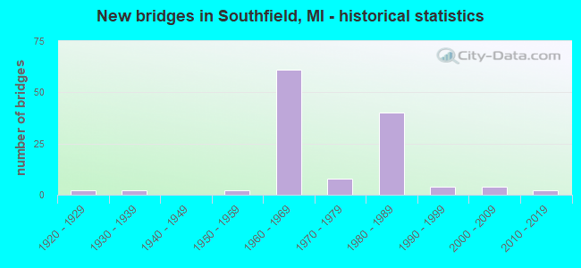
- New bridges - historical statistics
- 21920-1929
- 21930-1939
- 21950-1959
- 611960-1969
- 81970-1979
- 401980-1989
- 41990-1999
- 42000-2009
- 22010-2019
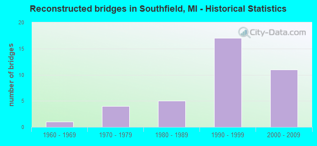
- Reconstructed bridges - Historical Statistics
- 11960-1969
- 41970-1979
- 51980-1989
- 171990-1999
- 112000-2009
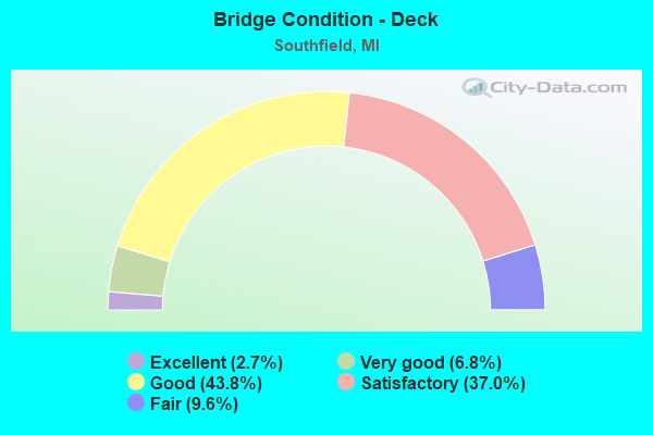
- Bridge Condition - Deck
- 2.7%Excellent
- 6.8%Very good
- 43.8%Good
- 37.0%Satisfactory
- 9.6%Fair
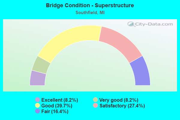
- Bridge Condition - Superstructure
- 8.2%Excellent
- 8.2%Very good
- 39.7%Good
- 27.4%Satisfactory
- 16.4%Fair
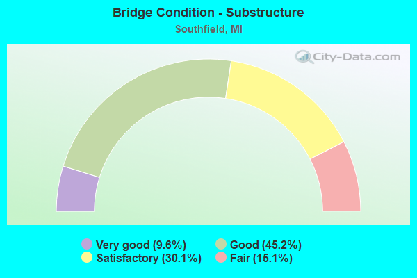
- Bridge Condition - Substructure
- 9.6%Very good
- 45.2%Good
- 30.1%Satisfactory
- 15.1%Fair
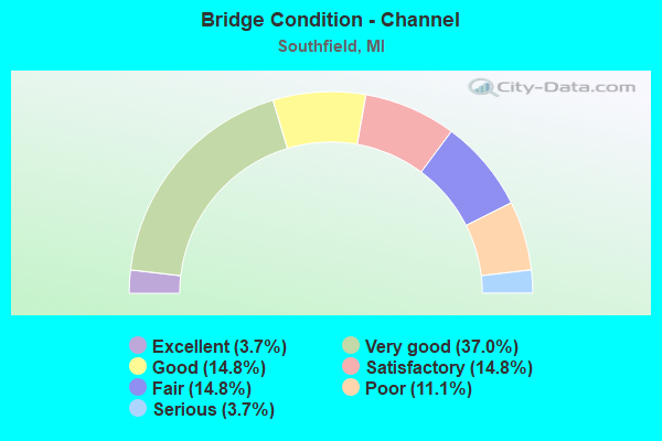
- Bridge Condition - Channel
- 3.7%Excellent
- 37.0%Very good
- 14.8%Good
- 14.8%Satisfactory
- 14.8%Fair
- 11.1%Poor
- 3.7%Serious
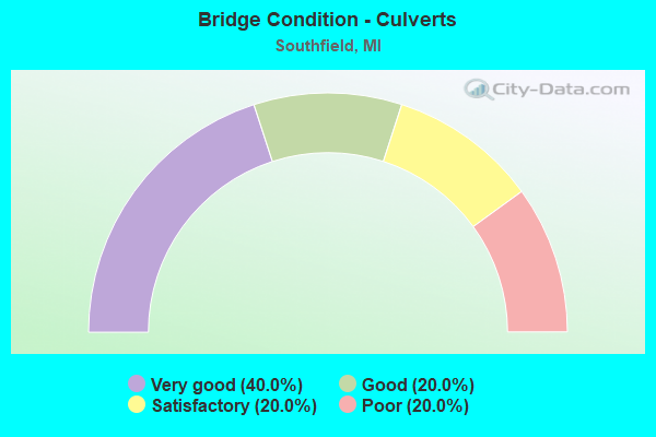
- Bridge Condition - Culverts
- 40.0%Very good
- 20.0%Good
- 20.0%Satisfactory
- 20.0%Poor
Find on map >> Show street view
Structure Number: 7913, Location: IN SOUTHFIELD (Lat: 42.487325, Lng: -83.278589), Route carried "on" structure: Interstate 696, Year Built: 1967, Year Reconstructed: 1988, Status: Open, Structure Length: 7.22m (23.69ft), Average Daily Traffic: 56,238 (year 2017), Truck Traffic: 7%, Average Future Daily Traffic: 62,138 (year 2037), Design Load: HS 20+Mod, Features Intersected: ROUGE RIVER
Minimum Vertical Clearance: 30.48m (100.00ft), Kilometerpoint: 14.407, Lanes on structure: 4, Base Highway Network: Yes (Inventory Route: 71, Subroute: 1), Owner: State Highway Agency, Approaching Roadway Width: 19.5m (64.0ft), Skew: 3 degrees, Material/Design: Steel, Design/Construction: Stringer/Multi-beam, Number Of Spans In Main Unit: 3, Length of Maximum Span: 24.1m (79.1ft), Curb-To-Curb Width: 20.0m (65.6ft), Out-to-Out Width: 21.0m (68.9ft)
Condition: Deck: Satisfactory, Superstructure: Very good, Substructure: Good, Channel: Very good, Operating Rating: 60.3 metric tons, Method Used To Determine Operating Rating: Load Factor (LF) rating reported by rating factor (RF) method using MS18 loading, Inventory Rating: 36.0 metric tons, Method Used To Determine Inventory Rating: Load Factor (LF) rating reported by rating factor (RF) method using MS18 loading, Structural Evaluation: Better than present minimum criteria, Deck Geometry: Equal to present minimum criteria, Waterway Adequacy: Equal to present desirable criteria, Approach Roadway Alignment: Equal to present desirable criteria, Designated Inspection Frequency: Every 24 months, Inspection Date: March 2020, Deck Structure Type: Concrete Cast-file-Place, Wearing Surface/Protective System: Wearing Surface: Epoxy Overlay, Deck Protection: Epoxy Coated Reinforcing
Find on map >> Show street view
Structure Number: 7914, Location: IN SOUTHFIELD (Lat: 42.487414, Lng: -83.278364), Route carried "on" structure: Interstate 696, Year Built: 1967, Year Reconstructed: 1988, Status: Open, Structure Length: 7.22m (23.69ft), Average Daily Traffic: 56,238 (year 2017), Truck Traffic: 7%, Average Future Daily Traffic: 62,138 (year 2037), Design Load: HS 20+Mod, Features Intersected: ROUGE RIVER
Minimum Vertical Clearance: 30.48m (100.00ft), Kilometerpoint: 14.406, Lanes on structure: 3, Base Highway Network: Yes (Inventory Route: 71, Subroute: 2), Owner: State Highway Agency, Approaching Roadway Width: 14.3m (46.9ft), Skew: 3 degrees, Material/Design: Steel, Design/Construction: Stringer/Multi-beam, Number Of Spans In Main Unit: 3, Length of Maximum Span: 24.1m (79.1ft), Curb-To-Curb Width: 16.6m (54.5ft), Out-to-Out Width: 17.7m (58.1ft)
Condition: Deck: Good, Superstructure: Good, Substructure: Satisfactory, Channel: Very good, Operating Rating: 61.9 metric tons, Method Used To Determine Operating Rating: Load Factor (LF) rating reported by rating factor (RF) method using MS18 loading, Inventory Rating: 36.9 metric tons, Method Used To Determine Inventory Rating: Load Factor (LF) rating reported by rating factor (RF) method using MS18 loading, Structural Evaluation: Equal to present minimum criteria, Deck Geometry: Equal to present minimum criteria, Waterway Adequacy: Equal to present desirable criteria, Approach Roadway Alignment: Equal to present desirable criteria, Designated Inspection Frequency: Every 24 months, Inspection Date: March 2020, Deck Structure Type: Concrete Cast-file-Place, Wearing Surface/Protective System: Wearing Surface: Epoxy Overlay, Deck Protection: Epoxy Coated Reinforcing
Find on map >> Show street view
Structure Number: 7917, Location: IN SOUTHFIELD (Lat: 42.487211, Lng: -83.281792), Route carried "on" structure: Ramp Interstate 696, Year Built: 1967, Year Reconstructed: 1988, Status: Open, Structure Length: 4.84m (15.88ft), Average Daily Traffic: 17,000 (year 1982), Truck Traffic: 5%, Average Future Daily Traffic: 17,000 (year 1977), Design Load: HS 20+Mod, Features Intersected: M-10 SB
Minimum Vertical Clearance: 30.48m (100.00ft), Kilometerpoint: 0.146, Lanes on structure: 1, Lanes under structure: 4, Owner: State Highway Agency, Approaching Roadway Width: 7.9m (25.9ft), Skew: 3 degrees, Material/Design: Steel, Design/Construction: Stringer/Multi-beam, Number Of Spans In Main Unit: 3, Length of Maximum Span: 25.4m (83.3ft), Curb or Sidewalk Widths: Left: 0.2m (0.7ft), Right: 0.2m (0.7ft), Curb-To-Curb Width: 7.0m (23.0ft), Out-to-Out Width: 8.2m (26.9ft)
Condition: Deck: Satisfactory, Superstructure: Good, Substructure: Good, Operating Rating: 61.6 metric tons, Method Used To Determine Operating Rating: Load Factor (LF) rating reported by rating factor (RF) method using MS18 loading, Inventory Rating: 36.9 metric tons, Method Used To Determine Inventory Rating: Load Factor (LF) rating reported by rating factor (RF) method using MS18 loading, Structural Evaluation: Better than present minimum criteria, Deck Geometry: Equal to present minimum criteria, Underclear: Meets minimum limits, Approach Roadway Alignment: Equal to present desirable criteria, Designated Inspection Frequency: Every 24 months, Inspection Date: March 2020, Deck Structure Type: Concrete Cast-file-Place, Wearing Surface/Protective System: Wearing Surface: Latex Concrete, Deck Protection: Epoxy Coated Reinforcing
Find on map >> Show street view
Structure Number: 7918, Location: IN SOUTHFIELD (Lat: 42.485467, Lng: -83.266747), Route carried "on" structure: Interstate 696, Year Built: 1967, Year Reconstructed: 1988, Status: Open, Structure Length: 9.23m (30.28ft), Average Daily Traffic: 122,300 (year 2007), Truck Traffic: 7%, Average Future Daily Traffic: 118,082 (year 2018), Design Load: HS 20+Mod, Features Intersected: M-10
Minimum Vertical Clearance: 30.48m (100.00ft), Kilometerpoint: 15.423, Lanes on structure: 6, Lanes under structure: 4, Base Highway Network: Yes (Inventory Route: 71, Subroute: 1), Owner: State Highway Agency, Approaching Roadway Width: 20.7m (67.9ft), Skew: 36 degrees, Material/Design: Steel, Design/Construction: Stringer/Multi-beam, Number Of Spans In Main Unit: 3, Length of Maximum Span: 47.8m (156.8ft), Curb-To-Curb Width: 36.2m (118.8ft), Out-to-Out Width: 38.1m (125.0ft)
Condition: Deck: Good, Superstructure: Fair, Substructure: Fair, Operating Rating: 68.0 metric tons, Method Used To Determine Operating Rating: Load Factor (LF) rating reported by rating factor (RF) method using MS18 loading, Inventory Rating: 40.8 metric tons, Method Used To Determine Inventory Rating: Load Factor (LF) rating reported by rating factor (RF) method using MS18 loading, Structural Evaluation: Somewhat better than minimum adequacy, Deck Geometry: Superior to present desirable criteria, Underclear: High priority of corrective action, Approach Roadway Alignment: Equal to present desirable criteria, Designated Inspection Frequency: Every 24 months, Inspection Date: April 2021, Deck Structure Type: Concrete Cast-file-Place, Wearing Surface/Protective System: Wearing Surface: Latex Concrete, Deck Protection: Epoxy Coated Reinforcing
Find on map >> Show street view
Structure Number: 7919, Location: CITY OF SOUTHFIELD (Lat: 42.485519, Lng: -83.261303), Route carried "on" structure: County highway 2059, Year Built: 1984, Status: Open, Structure Length: 7.35m (24.11ft), Average Daily Traffic: 15,000 (year 1982), Truck Traffic: 3%, Average Future Daily Traffic: 15,000 (year 1977), Design Load: HS 25 or greater, Features Intersected: I-696, Facility Carried by Structure: LAHSER ROAD
Minimum Vertical Clearance: 30.48m (100.00ft), Kilometerpoint: 4.703, Lanes on structure: 5, Lanes under structure: 8, Owner: State Highway Agency, Approaching Roadway Width: 14.6m (47.9ft), Material/Design: Prestressed concrete, Design/Construction: Stringer/Multi-beam, Number Of Spans In Main Unit: 3, Length of Maximum Span: 31.4m (103.0ft), Curb or Sidewalk Widths: Left: 2.4m (7.9ft), Right: 2.4m (7.9ft), Curb-To-Curb Width: 26.8m (87.9ft), Out-to-Out Width: 32.5m (106.6ft)
Condition: Deck: Good, Superstructure: Satisfactory, Substructure: Fair, Operating Rating: 56.1 metric tons, Method Used To Determine Operating Rating: Load Factor (LF) rating reported by rating factor (RF) method using MS18 loading, Inventory Rating: 23.0 metric tons, Method Used To Determine Inventory Rating: Load Factor (LF) rating reported by rating factor (RF) method using MS18 loading, Structural Evaluation: Somewhat better than minimum adequacy, Deck Geometry: Superior to present desirable criteria, Underclear: Somewhat better than minimum adequacy, Approach Roadway Alignment: Equal to present desirable criteria, Designated Inspection Frequency: Every 24 months, Inspection Date: July 2020, Deck Structure Type: Concrete Cast-file-Place, Wearing Surface/Protective System: Wearing Surface: Monolithic Concrete, Deck Protection: Epoxy Coated Reinforcing
Find on map >> Show street view
Structure Number: 792, Location: 0.4 MI EAST OF LASHER (Lat: 42.486600, Lng: -83.252581), Route carried "on" structure: City street , Year Built: 1985, Status: Open, Structure Length: 11.28m (37.01ft), Average Daily Traffic: 1,500 (year 1982), Truck Traffic: 3%, Average Future Daily Traffic: 1,500 (year 1977), Design Load: HS 25 or greater, Features Intersected: I-696, Facility Carried by Structure: 11 MILE ROAD
Minimum Vertical Clearance: 30.48m (100.00ft), Kilometerpoint: 0.193, Lanes on structure: 2, Lanes under structure: 8, Owner: State Highway Agency, Approaching Roadway Width: 14.6m (47.9ft), Skew: 9 degrees, Material/Design: Steel continuous, Design/Construction: Stringer/Multi-beam, Number Of Spans In Main Unit: 2, Length of Maximum Span: 57.9m (190.0ft), Curb or Sidewalk Widths: Left: 0.2m (0.7ft), Right: 2.4m (7.9ft), Curb-To-Curb Width: 9.5m (31.2ft), Out-to-Out Width: 13.0m (42.7ft)
Condition: Deck: Good, Superstructure: Good, Substructure: Good, Operating Rating: 71.0 metric tons, Method Used To Determine Operating Rating: Load Factor (LF) rating reported by rating factor (RF) method using MS18 loading, Inventory Rating: 42.4 metric tons, Method Used To Determine Inventory Rating: Load Factor (LF) rating reported by rating factor (RF) method using MS18 loading, Structural Evaluation: Better than present minimum criteria, Deck Geometry: Somewhat better than minimum adequacy, Underclear: Somewhat better than minimum adequacy, Approach Roadway Alignment: Equal to present desirable criteria, Designated Inspection Frequency: Every 24 months, Inspection Date: July 2020, Deck Structure Type: Concrete Cast-file-Place, Wearing Surface/Protective System: Wearing Surface: Monolithic Concrete, Deck Protection: Epoxy Coated Reinforcing
Find on map >> Show street view
Structure Number: 7921, Location: IN SOUTHFIELD (Lat: 42.487192, Lng: -83.241186), Route carried "on" structure: City street 2059, Year Built: 1985, Status: Open, Structure Length: 3.96m (12.99ft), Average Daily Traffic: 15,000 (year 1988), Truck Traffic: 3%, Average Future Daily Traffic: 17,250 (year 2008), Design Load: HS 25 or greater, Features Intersected: I-696, Facility Carried by Structure: EVERGREEN ROAD
Minimum Vertical Clearance: 30.48m (100.00ft), Kilometerpoint: 4.828, Lanes on structure: 7, Lanes under structure: 6, Owner: State Highway Agency, Approaching Roadway Width: 26.8m (87.9ft), Material/Design: Prestressed concrete, Design/Construction: Stringer/Multi-beam, Number Of Spans In Main Unit: 2, Length of Maximum Span: 19.8m (65.0ft), Curb or Sidewalk Widths: Left: 2.4m (7.9ft), Right: 2.4m (7.9ft), Curb-To-Curb Width: 26.8m (87.9ft), Out-to-Out Width: 32.5m (106.6ft)
Condition: Deck: Satisfactory, Superstructure: Satisfactory, Substructure: Good, Operating Rating: 67.0 metric tons, Method Used To Determine Operating Rating: Load Factor (LF), Inventory Rating: 36.2 metric tons, Method Used To Determine Inventory Rating: Load Factor (LF), Structural Evaluation: Equal to present minimum criteria, Deck Geometry: Somewhat better than minimum adequacy, Underclear: Equal to present minimum criteria, Approach Roadway Alignment: Equal to present desirable criteria, Designated Inspection Frequency: Every 24 months, Inspection Date: July 2020, Deck Structure Type: Concrete Cast-file-Place, Wearing Surface/Protective System: Wearing Surface: Monolithic Concrete, Deck Protection: Epoxy Coated Reinforcing
Find on map >> Show street view
Structure Number: 7926, Location: IN SOUTHFIELD (Lat: 42.487681, Lng: -83.212522), Route carried "on" structure: City street 2059, Year Built: 1987, Year Reconstructed: 2009, Status: Open, Structure Length: 8.71m (28.58ft), Average Daily Traffic: 450 (year 1982), Truck Traffic: 3%, Average Future Daily Traffic: 450 (year 1977), Design Load: HS 25 or greater, Features Intersected: I-696, Facility Carried by Structure: E B 11 MILE SER RO
Minimum Vertical Clearance: 30.48m (100.00ft), Kilometerpoint: 3.473, Lanes on structure: 2, Lanes under structure: 6, Owner: State Highway Agency, Approaching Roadway Width: 14.6m (47.9ft), Material/Design: Steel continuous, Design/Construction: Stringer/Multi-beam, Number Of Spans In Main Unit: 2, Length of Maximum Span: 45.6m (149.6ft), Curb or Sidewalk Widths: Left: 0.2m (0.7ft), Right: 2.4m (7.9ft), Curb-To-Curb Width: 8.9m (29.2ft), Out-to-Out Width: 12.2m (40.0ft)
Condition: Deck: Good, Superstructure: Very good, Substructure: Satisfactory, Operating Rating: 75.5 metric tons, Method Used To Determine Operating Rating: Load Factor (LF) rating reported by rating factor (RF) method using MS18 loading, Inventory Rating: 45.4 metric tons, Method Used To Determine Inventory Rating: Load Factor (LF) rating reported by rating factor (RF) method using MS18 loading, Structural Evaluation: Equal to present minimum criteria, Deck Geometry: Somewhat better than minimum adequacy, Underclear: Equal to present minimum criteria, Approach Roadway Alignment: Equal to present desirable criteria, Designated Inspection Frequency: Every 24 months, Inspection Date: July 2020, Deck Structure Type: Concrete Cast-file-Place, Wearing Surface/Protective System: Wearing Surface: Monolithic Concrete, Deck Protection: Epoxy Coated Reinforcing
Find on map >> Show street view
Structure Number: 7927, Location: CITY OF SOUTHFIELD (Lat: 42.480997, Lng: -83.207081), Route carried "on" structure: City street , Year Built: 1987, Status: Open, Structure Length: 5.61m (18.41ft), Average Daily Traffic: 1,500 (year 1982), Truck Traffic: 3%, Average Future Daily Traffic: 1,500 (year 1977), Design Load: HS 25 or greater, Features Intersected: I-696, Facility Carried by Structure: LINCOLN DRIVE
Minimum Vertical Clearance: 30.48m (100.00ft), Kilometerpoint: 1.972, Lanes on structure: 2, Lanes under structure: 10, Owner: State Highway Agency, Approaching Roadway Width: 14.6m (47.9ft), Material/Design: Prestressed concrete, Design/Construction: Stringer/Multi-beam, Number Of Spans In Main Unit: 2, Length of Maximum Span: 28.0m (91.9ft), Curb or Sidewalk Widths: Left: 2.4m (7.9ft), Right: 2.4m (7.9ft), Curb-To-Curb Width: 9.8m (32.2ft), Out-to-Out Width: 15.5m (50.9ft)
Condition: Deck: Good, Superstructure: Good, Substructure: Good, Operating Rating: 63.8 metric tons, Method Used To Determine Operating Rating: Load Factor (LF) rating reported by rating factor (RF) method using MS18 loading, Inventory Rating: 33.0 metric tons, Method Used To Determine Inventory Rating: Load Factor (LF) rating reported by rating factor (RF) method using MS18 loading, Structural Evaluation: Better than present minimum criteria, Deck Geometry: Somewhat better than minimum adequacy, Underclear: Equal to present minimum criteria, Approach Roadway Alignment: Equal to present desirable criteria, Designated Inspection Frequency: Every 24 months, Inspection Date: July 2020, Deck Structure Type: Concrete Cast-file-Place, Wearing Surface/Protective System: Wearing Surface: Monolithic Concrete, Deck Protection: Epoxy Coated Reinforcing
Find on map >> Show street view
Structure Number: 7928, Location: CITY OF SOUTHFIELD (Lat: 42.477461, Lng: -83.203150), Route carried "on" structure: Ramp County highway 2059, Year Built: 1987, Status: Open, Structure Length: 4.72m (15.49ft), Average Daily Traffic: 3,000 (year 1984), Truck Traffic: 3%, Average Future Daily Traffic: 3,000 (year 1977), Design Load: HS 20, Features Intersected: I-696, Facility Carried by Structure: U-TURN W.OF GRNFLD
Minimum Vertical Clearance: 30.48m (100.00ft), Kilometerpoint: 0.023, Lanes on structure: 2, Lanes under structure: 8, Owner: State Highway Agency, Approaching Roadway Width: 14.6m (47.9ft), Material/Design: Prestressed concrete, Design/Construction: Stringer/Multi-beam, Number Of Spans In Main Unit: 2, Length of Maximum Span: 23.7m (77.8ft), Curb-To-Curb Width: 9.3m (30.5ft), Out-to-Out Width: 10.6m (34.8ft)
Condition: Deck: Satisfactory, Superstructure: Satisfactory, Substructure: Good, Operating Rating: 59.6 metric tons, Method Used To Determine Operating Rating: Load Factor (LF) rating reported by rating factor (RF) method using MS18 loading, Inventory Rating: 31.4 metric tons, Method Used To Determine Inventory Rating: Load Factor (LF) rating reported by rating factor (RF) method using MS18 loading, Structural Evaluation: Equal to present minimum criteria, Deck Geometry: Somewhat better than minimum adequacy, Underclear: Somewhat better than minimum adequacy, Approach Roadway Alignment: Equal to present desirable criteria, Designated Inspection Frequency: Every 24 months, Inspection Date: July 2020, Deck Structure Type: Concrete Cast-file-Place, Wearing Surface/Protective System: Wearing Surface: Monolithic Concrete, Deck Protection: Epoxy Coated Reinforcing
Find on map >> Show street view
Structure Number: 7929, Location: 1/4 MI.N. OF 10 MILE (Lat: 42.476939, Lng: -83.201872), Route carried "on" structure: County highway 2059, Year Built: 1987, Status: Open, Structure Length: 4.92m (16.14ft), Average Daily Traffic: 50,100 (year 1995), Truck Traffic: 3%, Average Future Daily Traffic: 59,000 (year 2010), Design Load: HS 20, Features Intersected: I-696, Facility Carried by Structure: GREENFIELD ROAD
Minimum Vertical Clearance: 30.48m (100.00ft), Kilometerpoint: 3.571, Lanes on structure: 6, Lanes under structure: 8, Base Highway Network: Yes (Inventory Route: 64, Subroute: 7), Owner: State Highway Agency, Approaching Roadway Width: 20.1m (65.9ft), Skew: 31 degrees, Material/Design: Prestressed concrete, Design/Construction: Stringer/Multi-beam, Number Of Spans In Main Unit: 2, Length of Maximum Span: 24.6m (80.7ft), Curb or Sidewalk Widths: Left: 2.1m (6.9ft), Right: 2.1m (6.9ft), Curb-To-Curb Width: 22.6m (74.1ft), Out-to-Out Width: 35.6m (116.8ft)
Condition: Deck: Satisfactory, Superstructure: Good, Substructure: Good, Operating Rating: 39.2 metric tons, Method Used To Determine Operating Rating: Load and Resistance Factor Rating (LRFR) rating reported by rating factor(RF) method using HL-93 loadings, Inventory Rating: 30.8 metric tons, Method Used To Determine Inventory Rating: Load and Resistance Factor Rating (LRFR) rating reported by rating factor(RF) method using HL-93 loadings, Structural Evaluation: Better than present minimum criteria, Deck Geometry: Meets minimum limits, Underclear: Equal to present minimum criteria, Approach Roadway Alignment: Equal to present desirable criteria, Designated Inspection Frequency: Every 24 months, Inspection Date: July 2020, Deck Structure Type: Concrete Cast-file-Place, Wearing Surface/Protective System: Wearing Surface: Monolithic Concrete, Deck Protection: Epoxy Coated Reinforcing
Find on map >> Show street view
Structure Number: 793, Location: IN ROYAL OAK TOWNSHIP (Lat: 42.477008, Lng: -83.200589), Route carried "on" structure: Ramp County highway 2059, Year Built: 1987, Status: Open, Structure Length: 4.74m (15.55ft), Average Daily Traffic: 4,000 (year 1984), Truck Traffic: 3%, Average Future Daily Traffic: 4,000 (year 1977), Design Load: HS 20, Features Intersected: I-696, Facility Carried by Structure: U-TURN E.OF GRNFLD
Minimum Vertical Clearance: 30.48m (100.00ft), Kilometerpoint: 0.019, Lanes on structure: 2, Lanes under structure: 8, Owner: State Highway Agency, Approaching Roadway Width: 14.6m (47.9ft), Material/Design: Prestressed concrete, Design/Construction: Stringer/Multi-beam, Number Of Spans In Main Unit: 2, Length of Maximum Span: 23.7m (77.8ft), Curb or Sidewalk Widths: Left: 0.2m (0.7ft), Right: 0.2m (0.7ft), Curb-To-Curb Width: 9.3m (30.5ft), Out-to-Out Width: 10.6m (34.8ft)
Condition: Deck: Good, Superstructure: Good, Substructure: Good, Operating Rating: 60.9 metric tons, Method Used To Determine Operating Rating: Load Factor (LF) rating reported by rating factor (RF) method using MS18 loading, Inventory Rating: 32.1 metric tons, Method Used To Determine Inventory Rating: Load Factor (LF) rating reported by rating factor (RF) method using MS18 loading, Structural Evaluation: Better than present minimum criteria, Deck Geometry: Somewhat better than minimum adequacy, Underclear: Equal to present minimum criteria, Approach Roadway Alignment: Equal to present desirable criteria, Designated Inspection Frequency: Every 24 months, Inspection Date: July 2020, Deck Structure Type: Concrete Cast-file-Place, Wearing Surface/Protective System: Wearing Surface: Monolithic Concrete, Deck Protection: Epoxy Coated Reinforcing
Find on map >> Show street view
Structure Number: 7945, Location: 0.2 MI EAST OF LASHER (Lat: 42.485561, Lng: -83.257800), Route carried "on" structure: City street , Year Built: 1985, Status: Open, Structure Length: 7.19m (23.59ft), Average Daily Traffic: 1,500 (year 1982), Truck Traffic: 3%, Average Future Daily Traffic: 1,500 (year 1977), Design Load: HS 25 or greater, Features Intersected: I-696, Facility Carried by Structure: CORPORATE DR
Minimum Vertical Clearance: 30.48m (100.00ft), Kilometerpoint: 0.343, Lanes on structure: 2, Lanes under structure: 6, Owner: State Highway Agency, Approaching Roadway Width: 8.5m (27.9ft), Material/Design: Prestressed concrete, Design/Construction: Stringer/Multi-beam, Number Of Spans In Main Unit: 2, Length of Maximum Span: 36.9m (121.1ft), Curb or Sidewalk Widths: Left: 2.4m (7.9ft), Right: 2.4m (7.9ft), Curb-To-Curb Width: 8.5m (27.9ft), Out-to-Out Width: 14.2m (46.6ft)
Condition: Deck: Good, Superstructure: Good, Substructure: Satisfactory, Operating Rating: 73.2 metric tons, Method Used To Determine Operating Rating: Load Factor (LF) rating reported by rating factor (RF) method using MS18 loading, Inventory Rating: 31.4 metric tons, Method Used To Determine Inventory Rating: Load Factor (LF) rating reported by rating factor (RF) method using MS18 loading, Structural Evaluation: Equal to present minimum criteria, Deck Geometry: Somewhat better than minimum adequacy, Underclear: Somewhat better than minimum adequacy, Approach Roadway Alignment: Equal to present desirable criteria, Designated Inspection Frequency: Every 24 months, Inspection Date: July 2020, Deck Structure Type: Concrete Cast-file-Place, Wearing Surface/Protective System: Wearing Surface: Monolithic Concrete, Deck Protection: Epoxy Coated Reinforcing
Find on map >> Show street view
Structure Number: 7946, Location: SOUTHFIELD,W/CENT PK BLVD (Lat: 42.486842, Lng: -83.249425), Route carried "on" structure: City street 2059, Year Built: 1987, Status: Open, Structure Length: 5.34m (17.52ft), Average Daily Traffic: 2,400 (year 1993), Truck Traffic: 3%, Average Future Daily Traffic: 1,500 (year 1977), Design Load: HS 20, Features Intersected: I-696, Facility Carried by Structure: HARVARD
Minimum Vertical Clearance: 30.48m (100.00ft), Kilometerpoint: 0.029, Lanes on structure: 2, Lanes under structure: 8, Owner: State Highway Agency, Approaching Roadway Width: 14.6m (47.9ft), Skew: 30 degrees, Material/Design: Prestressed concrete, Design/Construction: Stringer/Multi-beam, Number Of Spans In Main Unit: 2, Length of Maximum Span: 29.3m (96.1ft), Curb or Sidewalk Widths: Left: 0.2m (0.7ft), Right: 2.4m (7.9ft), Curb-To-Curb Width: 12.8m (42.0ft), Out-to-Out Width: 18.9m (62.0ft)
Condition: Deck: Good, Superstructure: Good, Substructure: Satisfactory, Operating Rating: 68.4 metric tons, Method Used To Determine Operating Rating: Load Factor (LF) rating reported by rating factor (RF) method using MS18 loading, Inventory Rating: 31.1 metric tons, Method Used To Determine Inventory Rating: Load Factor (LF) rating reported by rating factor (RF) method using MS18 loading, Structural Evaluation: Equal to present minimum criteria, Deck Geometry: Equal to present minimum criteria, Underclear: Meets minimum limits, Approach Roadway Alignment: Equal to present desirable criteria, Designated Inspection Frequency: Every 24 months, Inspection Date: July 2020, Deck Structure Type: Concrete Cast-file-Place, Wearing Surface/Protective System: Wearing Surface: Monolithic Concrete, Deck Protection: Epoxy Coated Reinforcing
Find on map >> Show street view
Structure Number: 7947, Location: IN SOUTHFIELD (Lat: 42.487111, Lng: -83.244664), Route carried "on" structure: City street , Year Built: 1986, Status: Open, Structure Length: 3.96m (12.99ft), Average Daily Traffic: 1,500 (year 1982), Truck Traffic: 3%, Average Future Daily Traffic: 1,500 (year 1977), Design Load: HS 25 or greater, Features Intersected: I-696, Facility Carried by Structure: CENTRAL PARK BLVD
Minimum Vertical Clearance: 30.48m (100.00ft), Kilometerpoint: 0.793, Lanes on structure: 2, Lanes under structure: 4, Owner: State Highway Agency, Approaching Roadway Width: 14.6m (47.9ft), Material/Design: Prestressed concrete, Design/Construction: Stringer/Multi-beam, Number Of Spans In Main Unit: 2, Length of Maximum Span: 19.8m (65.0ft), Curb or Sidewalk Widths: Left: 2.4m (7.9ft), Right: 2.4m (7.9ft), Curb-To-Curb Width: 19.8m (65.0ft), Out-to-Out Width: 25.5m (83.7ft)
Condition: Deck: Satisfactory, Superstructure: Good, Substructure: Satisfactory, Operating Rating: 64.2 metric tons, Method Used To Determine Operating Rating: Load Factor (LF) rating reported by rating factor (RF) method using MS18 loading, Inventory Rating: 34.0 metric tons, Method Used To Determine Inventory Rating: Load Factor (LF) rating reported by rating factor (RF) method using MS18 loading, Structural Evaluation: Equal to present minimum criteria, Deck Geometry: Superior to present desirable criteria, Underclear: Equal to present minimum criteria, Approach Roadway Alignment: Equal to present desirable criteria, Designated Inspection Frequency: Every 24 months, Inspection Date: July 2020, Deck Structure Type: Concrete Cast-file-Place, Wearing Surface/Protective System: Wearing Surface: Monolithic Concrete, Deck Protection: Epoxy Coated Reinforcing
Find on map >> Show street view
Structure Number: 7948, Location: 0.1 M W OF EVERGREEN (Lat: 42.487336, Lng: -83.242878), Route carried "on" structure: City street , Year Built: 1986, Status: Open, Structure Length: 3.96m (12.99ft), Average Daily Traffic: 1,500 (year 1982), Truck Traffic: 3%, Average Future Daily Traffic: 1,500 (year 1977), Design Load: HS 25 or greater, Features Intersected: I-696, Facility Carried by Structure: MEADOWLARK U EAST
Minimum Vertical Clearance: 30.48m (100.00ft), Kilometerpoint: 0.024, Lanes on structure: 2, Lanes under structure: 6, Owner: State Highway Agency, Approaching Roadway Width: 14.6m (47.9ft), Material/Design: Prestressed concrete, Design/Construction: Stringer/Multi-beam, Number Of Spans In Main Unit: 2, Length of Maximum Span: 19.8m (65.0ft), Curb or Sidewalk Widths: Left: 0.2m (0.7ft), Right: 0.2m (0.7ft), Curb-To-Curb Width: 9.3m (30.5ft), Out-to-Out Width: 10.6m (34.8ft)
Condition: Deck: Satisfactory, Superstructure: Good, Substructure: Good, Operating Rating: 61.2 metric tons, Method Used To Determine Operating Rating: Load Factor (LF) rating reported by rating factor (RF) method using MS18 loading, Inventory Rating: 35.3 metric tons, Method Used To Determine Inventory Rating: Load Factor (LF) rating reported by rating factor (RF) method using MS18 loading, Structural Evaluation: Better than present minimum criteria, Deck Geometry: Somewhat better than minimum adequacy, Underclear: Equal to present minimum criteria, Approach Roadway Alignment: Equal to present desirable criteria, Designated Inspection Frequency: Every 24 months, Inspection Date: July 2020, Deck Structure Type: Concrete Cast-file-Place, Wearing Surface/Protective System: Wearing Surface: Monolithic Concrete, Deck Protection: Epoxy Coated Reinforcing
Find on map >> Show street view
Structure Number: 7949, Location: E OF EVERGREEN (Lat: 42.487428, Lng: -83.239533), Route carried "on" structure: City street , Year Built: 1987, Status: Open, Structure Length: 3.96m (12.99ft), Average Daily Traffic: 5,800 (year 1982), Truck Traffic: 3%, Average Future Daily Traffic: 5,800 (year 1977), Design Load: HS 25 or greater, Features Intersected: I-696, Facility Carried by Structure: RED RIVER AVE U-T
Minimum Vertical Clearance: 30.48m (100.00ft), Kilometerpoint: 0.026, Lanes on structure: 4, Lanes under structure: 6, Owner: State Highway Agency, Approaching Roadway Width: 14.6m (47.9ft), Skew: 30 degrees, Material/Design: Prestressed concrete, Design/Construction: Stringer/Multi-beam, Number Of Spans In Main Unit: 2, Length of Maximum Span: 19.8m (65.0ft), Curb or Sidewalk Widths: Left: 0.2m (0.7ft), Right: 0.2m (0.7ft), Curb-To-Curb Width: 15.3m (50.2ft), Out-to-Out Width: 19.6m (64.3ft)
Condition: Deck: Satisfactory, Superstructure: Good, Substructure: Good, Operating Rating: 59.9 metric tons, Method Used To Determine Operating Rating: Load Factor (LF) rating reported by rating factor (RF) method using MS18 loading, Inventory Rating: 36.0 metric tons, Method Used To Determine Inventory Rating: Load Factor (LF) rating reported by rating factor (RF) method using MS18 loading, Structural Evaluation: Better than present minimum criteria, Deck Geometry: High priority of corrective action, Underclear: Equal to present minimum criteria, Approach Roadway Alignment: Equal to present desirable criteria, Designated Inspection Frequency: Every 24 months, Inspection Date: July 2020, Deck Structure Type: Concrete Cast-file-Place, Wearing Surface/Protective System: Wearing Surface: Monolithic Concrete, Deck Protection: Epoxy Coated Reinforcing
Find on map >> Show street view
Structure Number: 795, Location: IN LATHRUP VILLAGE (Lat: 42.487592, Lng: -83.230514), Route carried "on" structure: County highway 2059, Year Built: 1987, Status: Open, Structure Length: 4.69m (15.39ft), Average Daily Traffic: 1,500 (year 1982), Truck Traffic: 3%, Average Future Daily Traffic: 1,500 (year 1977), Design Load: HS 25 or greater, Features Intersected: I-696, Facility Carried by Structure: SANTA BARBARA U EA
Minimum Vertical Clearance: 30.48m (100.00ft), Kilometerpoint: 1.440, Lanes on structure: 1, Lanes under structure: 6, Owner: State Highway Agency, Approaching Roadway Width: 14.6m (47.9ft), Material/Design: Prestressed concrete, Design/Construction: Stringer/Multi-beam, Number Of Spans In Main Unit: 2, Length of Maximum Span: 23.5m (77.1ft), Curb or Sidewalk Widths: Left: 0.2m (0.7ft), Right: 2.4m (7.9ft), Curb-To-Curb Width: 6.4m (21.0ft), Out-to-Out Width: 9.9m (32.5ft)
Condition: Deck: Satisfactory, Superstructure: Satisfactory, Substructure: Good, Operating Rating: 62.9 metric tons, Method Used To Determine Operating Rating: Load Factor (LF) rating reported by rating factor (RF) method using MS18 loading, Inventory Rating: 35.0 metric tons, Method Used To Determine Inventory Rating: Load Factor (LF) rating reported by rating factor (RF) method using MS18 loading, Structural Evaluation: Equal to present minimum criteria, Deck Geometry: High priority of replacement, Underclear: Somewhat better than minimum adequacy, Approach Roadway Alignment: Equal to present desirable criteria, Designated Inspection Frequency: Every 24 months, Inspection Date: July 2020, Deck Structure Type: Concrete Cast-file-Place, Wearing Surface/Protective System: Wearing Surface: Monolithic Concrete, Deck Protection: Epoxy Coated Reinforcing
Find on map >> Show street view
Structure Number: 7994, Location: IN SOUTHFIELD (Lat: 42.451286, Lng: -83.219856), Route carried "on" structure: City street , Year Built: 1963, Year Reconstructed: 2000, Status: Open, Structure Length: 3.32m (10.89ft), Average Daily Traffic: 1,500 (year 1984), Truck Traffic: 3%, Average Future Daily Traffic: 320 (year 1977), Design Load: HS 20, Features Intersected: M-39, Facility Carried by Structure: CORNELL RD
Minimum Vertical Clearance: 30.48m (100.00ft), Kilometerpoint: 0.045, Lanes on structure: 3, Lanes under structure: 6, Owner: State Highway Agency, Approaching Roadway Width: 6.1m (20.0ft), Skew: 30 degrees, Material/Design: Prestressed concrete, Design/Construction: Stringer/Multi-beam, Number Of Spans In Main Unit: 2, Length of Maximum Span: 16.4m (53.8ft), Curb or Sidewalk Widths: Left: 1.9m (6.2ft), Right: 1.9m (6.2ft), Curb-To-Curb Width: 13.4m (44.0ft), Out-to-Out Width: 17.9m (58.7ft)
Condition: Deck: Good, Superstructure: Good, Substructure: Satisfactory, Operating Rating: 74.8 metric tons, Method Used To Determine Operating Rating: Load Factor (LF) rating reported by rating factor (RF) method using MS18 loading, Inventory Rating: 45.4 metric tons, Method Used To Determine Inventory Rating: Load Factor (LF) rating reported by rating factor (RF) method using MS18 loading, Structural Evaluation: Equal to present minimum criteria, Deck Geometry: Somewhat better than minimum adequacy, Underclear: High priority of corrective action, Approach Roadway Alignment: Equal to present desirable criteria, Length Of Structure Improvement: 3.32m (10.89ft), Designated Inspection Frequency: Every 24 months, Inspection Date: June 2021, Bridge Improvement Cost: $151,000, Roadway Improvement Cost: $7,000, Total Project Cost: $77,000, Deck Structure Type: Concrete Cast-file-Place, Wearing Surface/Protective System: Wearing Surface: Monolithic Concrete
Find on map >> Show street view
Structure Number: 8147, Location: BET 9 AND 10 MILE RDS (Lat: 42.467650, Lng: -83.260525), Route carried "on" structure: County highway 2059, Year Built: 1983, Status: Open, Structure Length: 2.19m (7.19ft), Average Daily Traffic: 17,080 (year 1994), Average Future Daily Traffic: 20,100 (year 2014), Design Load: HS 20+Mod, Features Intersected: ROUGE RIVER, Facility Carried by Structure: LAHSER RD
Minimum Vertical Clearance: 30.48m (100.00ft), Kilometerpoint: 2.717, Lanes on structure: 5, Owner: County Highway Agency, Approaching Roadway Width: 19.5m (64.0ft), Skew: 3 degrees, Material/Design: Prestressed concrete, Design/Construction: Stringer/Multi-beam, Number Of Spans In Main Unit: 1, Length of Maximum Span: 21.0m (68.9ft), Curb or Sidewalk Widths: Left: 3.0m (9.8ft), Right: 1.8m (5.9ft), Curb-To-Curb Width: 19.2m (63.0ft), Out-to-Out Width: 24.5m (80.4ft)
Condition: Deck: Satisfactory, Superstructure: Good, Substructure: Good, Channel: Satisfactory, Operating Rating: 86.0 metric tons, Method Used To Determine Operating Rating: Load Factor (LF), Inventory Rating: 46.4 metric tons, Method Used To Determine Inventory Rating: Load Factor (LF), Structural Evaluation: Better than present minimum criteria, Deck Geometry: Meets minimum limits, Waterway Adequacy: Equal to present desirable criteria, Approach Roadway Alignment: Equal to present desirable criteria, Designated Inspection Frequency: Every 24 months, Inspection Date: July 2020, Deck Structure Type: Concrete Cast-file-Place, Wearing Surface/Protective System: Wearing Surface: Monolithic Concrete, Deck Protection: Epoxy Coated Reinforcing
Find on map >> Show street view
Structure Number: 8164, Location: BET INKSTER AND BEECH (Lat: 42.471347, Lng: -83.303883), Route carried "on" structure: County highway 2059, Year Built: 1984, Status: Open, Structure Length: 1.34m (4.40ft), Average Daily Traffic: 10,737 (year 1990), Average Future Daily Traffic: 12,600 (year 2010), Design Load: HS 20+Mod, Features Intersected: PEBBLE CREEK, Facility Carried by Structure: 10 MILE RD
Minimum Vertical Clearance: 30.48m (100.00ft), Kilometerpoint: 5.834, Lanes on structure: 2, Owner: County Highway Agency, Approaching Roadway Width: 12.2m (40.0ft), Material/Design: Prestressed concrete, Design/Construction: Box Beam or Girders - Multiple, Number Of Spans In Main Unit: 1, Length of Maximum Span: 12.2m (40.0ft), Curb-To-Curb Width: 12.2m (40.0ft), Out-to-Out Width: 26.6m (87.3ft)
Condition: Deck: Good, Superstructure: Good, Substructure: Good, Channel: Poor, Operating Rating: 77.8 metric tons, Method Used To Determine Operating Rating: Load Factor (LF) rating reported by rating factor (RF) method using MS18 loading, Inventory Rating: 34.7 metric tons, Method Used To Determine Inventory Rating: Load Factor (LF) rating reported by rating factor (RF) method using MS18 loading, Structural Evaluation: Better than present minimum criteria, Deck Geometry: Somewhat better than minimum adequacy, Waterway Adequacy: Equal to present desirable criteria, Approach Roadway Alignment: Equal to present desirable criteria, Designated Inspection Frequency: Every 24 months, Inspection Date: July 2020, Wearing Surface/Protective System: Wearing Surface: Bituminous
Find on map >> Show street view
Structure Number: 8165, Location: BET TELEGRAPH AND BEECH (Lat: 42.471728, Lng: -83.288572), Route carried "on" structure: County highway 2059, Year Built: 1995, Status: Open, Structure Length: 2.16m (7.09ft), Average Daily Traffic: 16,418 (year 1995), Truck Traffic: 5%, Average Future Daily Traffic: 19,000 (year 2015), Design Load: HS 20+Mod, Features Intersected: ROUGE RIVER, Facility Carried by Structure: 10 MILE RD
Minimum Vertical Clearance: 30.48m (100.00ft), Kilometerpoint: 7.093, Lanes on structure: 2, Owner: County Highway Agency, Approaching Roadway Width: 12.0m (39.4ft), Material/Design: Prestressed concrete, Design/Construction: Box Beam or Girders - Multiple, Number Of Spans In Main Unit: 1, Length of Maximum Span: 21.6m (70.9ft), Curb or Sidewalk Widths: Left: 0.0m, Right: 1.6m (5.2ft), Curb-To-Curb Width: 21.0m (68.9ft), Out-to-Out Width: 23.8m (78.1ft)
Condition: Deck: Good, Superstructure: Good, Substructure: Good, Channel: Fair, Operating Rating: 53.9 metric tons, Method Used To Determine Operating Rating: Load Factor (LF), Inventory Rating: 20.2 metric tons, Method Used To Determine Inventory Rating: Load Factor (LF), Structural Evaluation: Somewhat better than minimum adequacy, Deck Geometry: Superior to present desirable criteria, Waterway Adequacy: Better than present minimum criteria, Approach Roadway Alignment: Equal to present desirable criteria, Designated Inspection Frequency: Every 24 months, Inspection Date: July 2020, Deck Structure Type: Concrete Cast-file-Place, Wearing Surface/Protective System: Wearing Surface: Monolithic Concrete, Deck Protection: Epoxy Coated Reinforcing
Find on map >> Show street view
Structure Number: 8166, Location: WEST OF NORTHWESTERN (Lat: 42.472725, Lng: -83.247922), Route carried "on" structure: County highway 2059, Year Built: 1982, Status: Open, Structure Length: 1.22m (4.00ft), Average Daily Traffic: 1,997 (year 1997), Truck Traffic: 5%, Average Future Daily Traffic: 40,000 (year 2017), Design Load: HS 20+Mod, Features Intersected: CLAIRE DRAIN, Facility Carried by Structure: 10 MILE ROAD
Minimum Vertical Clearance: 30.48m (100.00ft), Kilometerpoint: 10.437, Lanes on structure: 5, Owner: County Highway Agency, Approaching Roadway Width: 19.5m (64.0ft), Material/Design: Concrete, Design/Construction: Culvert, Number Of Spans In Main Unit: 2, Length of Maximum Span: 5.4m (17.7ft), Curb or Sidewalk Widths: Left: 1.5m (4.9ft), Right: 1.5m (4.9ft), Curb-To-Curb Width: 19.5m (64.0ft), Out-to-Out Width: 32.2m (105.6ft)
Condition: Channel: Poor, Culverts: Good, Operating Rating: 55.4 metric tons, Method Used To Determine Operating Rating: Load Factor (LF) rating reported by rating factor (RF) method using MS18 loading, Inventory Rating: 33.4 metric tons, Method Used To Determine Inventory Rating: Load Factor (LF) rating reported by rating factor (RF) method using MS18 loading, Structural Evaluation: Better than present minimum criteria, Deck Geometry: Meets minimum limits, Waterway Adequacy: Equal to present minimum criteria, Approach Roadway Alignment: Equal to present desirable criteria, Designated Inspection Frequency: Every 24 months, Inspection Date: July 2020, Deck Structure Type: Concrete Cast-file-Place, Wearing Surface/Protective System: Wearing Surface: Bituminous, Deck Protection: Epoxy Coated Reinforcing
Find on map >> Show street view
Structure Number: 8169, Location: BET TELEGRAPH AND LAHSER (Lat: 42.501183, Lng: -83.278728), Route carried "on" structure: County highway 2059, Year Built: 1972, Status: Posted for load, Structure Length: 3.51m (11.52ft), Average Daily Traffic: 19,870 (year 2012), Truck Traffic: 3%, Average Future Daily Traffic: 26,800 (year 2032), Design Load: HS 20+Mod, Features Intersected: ROUGE RIVER, Facility Carried by Structure: 12 MILE RD (WEST)
Minimum Vertical Clearance: 30.48m (100.00ft), Kilometerpoint: 19.551, Lanes on structure: 5, Base Highway Network: Yes (Inventory Route: 446, Subroute: 80), Owner: County Highway Agency, Approaching Roadway Width: 18.9m (62.0ft), Material/Design: Concrete continuous, Design/Construction: Slab, Number Of Spans In Main Unit: 3, Length of Maximum Span: 13.4m (44.0ft), Curb or Sidewalk Widths: Left: 1.7m (5.6ft), Right: 1.7m (5.6ft), Curb-To-Curb Width: 18.6m (61.0ft), Out-to-Out Width: 22.7m (74.5ft)
Condition: Deck: Good, Superstructure: Good, Substructure: Good, Channel: Fair, Operating Rating: 42.3 metric tons, Method Used To Determine Operating Rating: Load Factor (LF), Inventory Rating: 25.3 metric tons, Method Used To Determine Inventory Rating: Load Factor (LF), Structural Evaluation: Equal to present minimum criteria, Deck Geometry: High priority of corrective action, Waterway Adequacy: Somewhat better than minimum adequacy, Approach Roadway Alignment: Equal to present desirable criteria, Bridge Posting: Required (Relationship of Operating Rating to Maximum Legal Load: 10.0 - 19.9% below), Designated Inspection Frequency: Every 24 months, Inspection Date: March 2020, Deck Structure Type: Concrete Cast-file-Place, Wearing Surface/Protective System: Wearing Surface: Epoxy Overlay
Find on map >> Show street view
Structure Number: 817, Location: BET TELEGRAPH AND LAHSER (Lat: 42.501272, Lng: -83.273736), Route carried "on" structure: County highway 2059, Year Built: 1972, Status: Posted for load, Structure Length: 3.51m (11.52ft), Average Daily Traffic: 19,870 (year 2012), Truck Traffic: 3%, Average Future Daily Traffic: 26,800 (year 2032), Design Load: HS 20+Mod, Features Intersected: ROUGE RIVER, Facility Carried by Structure: 12 MILE RD (EAST)
Minimum Vertical Clearance: 30.48m (100.00ft), Kilometerpoint: 19.961, Lanes on structure: 5, Base Highway Network: Yes (Inventory Route: 446, Subroute: 80), Owner: County Highway Agency, Approaching Roadway Width: 18.9m (62.0ft), Material/Design: Concrete continuous, Design/Construction: Slab, Number Of Spans In Main Unit: 3, Length of Maximum Span: 13.4m (44.0ft), Curb or Sidewalk Widths: Left: 1.7m (5.6ft), Right: 1.7m (5.6ft), Curb-To-Curb Width: 18.6m (61.0ft), Out-to-Out Width: 22.7m (74.5ft)
Condition: Deck: Good, Superstructure: Good, Substructure: Good, Channel: Fair, Operating Rating: 42.3 metric tons, Method Used To Determine Operating Rating: Load Factor (LF), Inventory Rating: 25.3 metric tons, Method Used To Determine Inventory Rating: Load Factor (LF), Structural Evaluation: Equal to present minimum criteria, Deck Geometry: High priority of corrective action, Waterway Adequacy: Equal to present desirable criteria, Approach Roadway Alignment: Equal to present desirable criteria, Bridge Posting: Required (Relationship of Operating Rating to Maximum Legal Load: 10.0 - 19.9% below), Designated Inspection Frequency: Every 24 months, Inspection Date: March 2020, Deck Structure Type: Concrete Cast-file-Place, Wearing Surface/Protective System: Wearing Surface: Epoxy Overlay
Find on map >> Show street view
Structure Number: 829, Location: W OF BEECH RD (Lat: 42.456844, Lng: -83.305878), Route carried "on" structure: City street 2059, Year Built: 1930, Year Reconstructed: 2006, Status: Open, Structure Length: 3.14m (10.30ft), Average Daily Traffic: 7,976 (year 2011), Truck Traffic: 1%, Average Future Daily Traffic: 8,215 (year 2013), Design Load: HS 25 or greater, Features Intersected: RIVER ROUGE, Facility Carried by Structure: NINE MILE RD
Minimum Vertical Clearance: 30.48m (100.00ft), Kilometerpoint: 0.964, Lanes on structure: 2, Owner: City or Municipal Highway Agency, Approaching Roadway Width: 12.2m (40.0ft), Material/Design: Prestressed concrete, Design/Construction: Stringer/Multi-beam, Number Of Spans In Main Unit: 1, Length of Maximum Span: 30.4m (99.7ft), Curb or Sidewalk Widths: Left: 4.3m (14.1ft), Right: 0.0m, Curb-To-Curb Width: 12.2m (40.0ft), Out-to-Out Width: 17.8m (58.4ft)
Condition: Deck: Very good, Superstructure: Excellent, Substructure: Very good, Channel: Excellent, Operating Rating: 71.6 metric tons, Method Used To Determine Operating Rating: Load and Resistance Factor Rating (LRFR) rating reported by rating factor(RF) method using HL-93 loadings, Inventory Rating: 55.1 metric tons, Method Used To Determine Inventory Rating: Load and Resistance Factor Rating (LRFR) rating reported by rating factor(RF) method using HL-93 loadings, Structural Evaluation: Equal to present desirable criteria, Deck Geometry: Somewhat better than minimum adequacy, Waterway Adequacy: Better than present minimum criteria, Approach Roadway Alignment: Equal to present desirable criteria, Designated Inspection Frequency: Every 24 months, Inspection Date: September 2021, Deck Structure Type: Concrete Cast-file-Place, Wearing Surface/Protective System: Wearing Surface: Monolithic Concrete, Deck Protection: Epoxy Coated Reinforcing
Find on map >> Show street view
Structure Number: 8291, Location: IN SOUTHFIELD (Lat: 42.457708, Lng: -83.267397), Route carried "on" structure: City street 2059, Year Built: 2019, Status: Open, Structure Length: 3.78m (12.40ft), Average Daily Traffic: 13,604 (year 2018), Truck Traffic: 2%, Average Future Daily Traffic: 14,735 (year 2038), Design Load: Greater than HL93, Features Intersected: EVANS BRANCH OF ROUGE RI, Facility Carried by Structure: NINE MILE RD
Minimum Vertical Clearance: 30.48m (100.00ft), Kilometerpoint: 4.130, Lanes on structure: 3, Owner: City or Municipal Highway Agency, Approaching Roadway Width: 11.9m (39.0ft), Material/Design: Prestressed concrete, Design/Construction: Stringer/Multi-beam, Number Of Spans In Main Unit: 1, Length of Maximum Span: 36.7m (120.4ft), Curb or Sidewalk Widths: Left: 2.4m (7.9ft), Right: 2.4m (7.9ft), Curb-To-Curb Width: 12.8m (42.0ft), Out-to-Out Width: 19.2m (63.0ft)
Condition: Deck: Very good, Superstructure: Excellent, Substructure: Very good, Channel: Very good, Operating Rating: 71.0 metric tons, Method Used To Determine Operating Rating: Load and Resistance Factor Rating (LRFR) rating reported by rating factor(RF) method using HL-93 loadings, Inventory Rating: 54.8 metric tons, Method Used To Determine Inventory Rating: Load and Resistance Factor Rating (LRFR) rating reported by rating factor(RF) method using HL-93 loadings, Structural Evaluation: Equal to present desirable criteria, Deck Geometry: Meets minimum limits, Waterway Adequacy: Superior to present desirable criteria, Approach Roadway Alignment: Equal to present desirable criteria, Length Of Structure Improvement: 9.15m (30.02ft), Designated Inspection Frequency: Every 24 months, Inspection Date: September 2021, Bridge Improvement Cost: $3,184,000, Roadway Improvement Cost: $572,000, Total Project Cost: $4,943,000 ( Estimate for 2017), Deck Structure Type: Concrete Cast-file-Place, Wearing Surface/Protective System: Wearing Surface: Monolithic Concrete, Deck Protection: Epoxy Coated Reinforcing
Find on map >> Show street view
Structure Number: 8292, Location: IN SOUTHFIELD (Lat: 42.485817, Lng: -83.308603), Route carried "on" structure: City street 2059, Year Built: 1972, Status: Open, Structure Length: 0.82m (2.69ft), Average Daily Traffic: 10,483 (year 2011), Truck Traffic: 2%, Average Future Daily Traffic: 10,798 (year 2013), Design Load: HS 20+Mod, Features Intersected: PEBBLE CREEK, Facility Carried by Structure: ELEVEN MILE RD
Minimum Vertical Clearance: 30.48m (100.00ft), Kilometerpoint: 5.662, Lanes on structure: 2, Owner: City or Municipal Highway Agency, Approaching Roadway Width: 21.0m (68.9ft), Skew: 1 degrees, Material/Design: Concrete, Design/Construction: Culvert, Number Of Spans In Main Unit: 2, Length of Maximum Span: 7.6m (24.9ft)
Condition: Channel: Very good, Culverts: Very good, Operating Rating: 56.1 metric tons, Method Used To Determine Operating Rating: Load Factor (LF) rating reported by rating factor (RF) method using MS18 loading, Inventory Rating: 33.4 metric tons, Method Used To Determine Inventory Rating: Load Factor (LF) rating reported by rating factor (RF) method using MS18 loading, Structural Evaluation: Equal to present desirable criteria, Waterway Adequacy: Equal to present desirable criteria, Approach Roadway Alignment: Equal to present desirable criteria, Designated Inspection Frequency: Every 24 months, Inspection Date: September 2021
Find on map >> Show street view
Structure Number: 8294, Location: IN SOUTHFIELD (Lat: 42.447817, Lng: -83.297650), Route carried "on" structure: City street 2059, Year Built: 2012, Status: Open, Structure Length: 2.19m (7.19ft), Average Daily Traffic: 6,637 (year 2012), Truck Traffic: 4%, Average Future Daily Traffic: 7,300 (year 2032), Design Load: Greater than HL93, Features Intersected: ROUGE RIVER, Facility Carried by Structure: BEECH RD
Minimum Vertical Clearance: 30.48m (100.00ft), Kilometerpoint: 0.613, Lanes on structure: 2, Owner: City or Municipal Highway Agency, Approaching Roadway Width: 12.2m (40.0ft), Skew: 1 degrees, Material/Design: Prestressed concrete, Design/Construction: Stringer/Multi-beam, Number Of Spans In Main Unit: 1, Length of Maximum Span: 20.7m (67.9ft), Curb or Sidewalk Widths: Left: 0.5m (1.6ft), Right: 2.3m (7.5ft), Curb-To-Curb Width: 12.2m (40.0ft), Out-to-Out Width: 15.0m (49.2ft)
Condition: Deck: Very good, Superstructure: Excellent, Substructure: Very good, Channel: Very good, Operating Rating: 79.1 metric tons, Method Used To Determine Operating Rating: Load and Resistance Factor Rating (LRFR) rating reported by rating factor(RF) method using HL-93 loadings, Inventory Rating: 60.9 metric tons, Method Used To Determine Inventory Rating: Load and Resistance Factor Rating (LRFR) rating reported by rating factor(RF) method using HL-93 loadings, Structural Evaluation: Equal to present desirable criteria, Deck Geometry: Somewhat better than minimum adequacy, Waterway Adequacy: Equal to present desirable criteria, Approach Roadway Alignment: Equal to present desirable criteria, Designated Inspection Frequency: Every 24 months, Inspection Date: September 2021, Deck Structure Type: Concrete Cast-file-Place, Wearing Surface/Protective System: Wearing Surface: Monolithic Concrete, Deck Protection: Epoxy Coated Reinforcing
Find on map >> Show street view
Structure Number: 8295, Location: IN SOUTHFIELD (Lat: 42.467228, Lng: -83.298575), Route carried "on" structure: City street 2059, Year Built: 1952, Status: Open, Structure Length: 1.67m (5.48ft), Average Daily Traffic: 5,629 (year 2011), Truck Traffic: 4%, Average Future Daily Traffic: 5,798 (year 2013), Design Load: HS 20+Mod, Features Intersected: ROUGE RIVER, Facility Carried by Structure: BEECH RD
Minimum Vertical Clearance: 30.48m (100.00ft), Kilometerpoint: 2.770, Lanes on structure: 2, Owner: City or Municipal Highway Agency, Approaching Roadway Width: 9.1m (29.9ft), Material/Design: Steel, Design/Construction: Stringer/Multi-beam, Number Of Spans In Main Unit: 1, Length of Maximum Span: 16.1m (52.8ft), Curb or Sidewalk Widths: Left: 0.7m (2.3ft), Right: 0.7m (2.3ft), Curb-To-Curb Width: 7.3m (24.0ft), Out-to-Out Width: 8.9m (29.2ft)
Condition: Deck: Fair, Superstructure: Fair, Substructure: Satisfactory, Channel: Good, Operating Rating: 46.7 metric tons, Method Used To Determine Operating Rating: Load and Resistance Factor Rating (LRFR) rating reported by rating factor(RF) method using HL-93 loadings, Inventory Rating: 36.0 metric tons, Method Used To Determine Inventory Rating: Load and Resistance Factor Rating (LRFR) rating reported by rating factor(RF) method using HL-93 loadings, Structural Evaluation: Somewhat better than minimum adequacy, Deck Geometry: High priority of replacement, Waterway Adequacy: Better than present minimum criteria, Approach Roadway Alignment: Equal to present desirable criteria, Length Of Structure Improvement: 1.67m (5.48ft), Designated Inspection Frequency: Every 18 months, Inspection Date: September 2021, Bridge Improvement Cost: $47,000, Roadway Improvement Cost: $12,000, Total Project Cost: $73,000, Deck Structure Type: Concrete Cast-file-Place, Wearing Surface/Protective System: Wearing Surface: Bituminous
Find on map >> Show street view
Structure Number: 8296, Location: IN SOUTHFIELD (Lat: 42.484381, Lng: -83.288867), Route carried "on" structure: City street 2059, Year Built: 1992, Status: Open, Structure Length: 0.67m (2.20ft), Average Daily Traffic: 19,439 (year 2010), Truck Traffic: 12%, Average Future Daily Traffic: 20,022 (year 2013), Design Load: HS 20+Mod, Features Intersected: PERNICK CREEK, Facility Carried by Structure: FRANKLIN RD
Minimum Vertical Clearance: 30.48m (100.00ft), Kilometerpoint: 2.350, Lanes on structure: 5, Owner: City or Municipal Highway Agency, Approaching Roadway Width: 18.9m (62.0ft), Material/Design: Concrete, Design/Construction: Culvert, Number Of Spans In Main Unit: 1, Length of Maximum Span: 6.1m (20.0ft), Curb or Sidewalk Widths: Left: 0.0m, Right: 0.1m (0.3ft)
Condition: Channel: Very good, Culverts: Very good, Operating Rating: 54.1 metric tons, Method Used To Determine Operating Rating: Load Factor (LF) rating reported by rating factor (RF) method using MS18 loading, Inventory Rating: 32.4 metric tons, Method Used To Determine Inventory Rating: Load Factor (LF) rating reported by rating factor (RF) method using MS18 loading, Structural Evaluation: Equal to present desirable criteria, Waterway Adequacy: Equal to present desirable criteria, Approach Roadway Alignment: Equal to present desirable criteria, Designated Inspection Frequency: Every 24 months, Inspection Date: September 2021
Find on map >> Show street view
Structure Number: 8297, Location: E OF TELEGRAPH RD (Lat: 42.488836, Lng: -83.276528), Route carried "on" structure: City street 2059, Year Built: 2004, Status: Open, Structure Length: 3.15m (10.33ft), Average Daily Traffic: 6,216 (year 2011), Truck Traffic: 1%, Average Future Daily Traffic: 6,403 (year 2013), Design Load: HS 25 or greater, Features Intersected: RIVER ROUGE, Facility Carried by Structure: ELEVEN MILE RD
Minimum Vertical Clearance: 30.48m (100.00ft), Kilometerpoint: 1.201, Lanes on structure: 2, Owner: City or Municipal Highway Agency, Approaching Roadway Width: 12.5m (41.0ft), Material/Design: Prestressed concrete, Design/Construction: Stringer/Multi-beam, Number Of Spans In Main Unit: 1, Length of Maximum Span: 30.5m (100.1ft), Curb or Sidewalk Widths: Left: 0.0m, Right: 2.7m (8.9ft), Curb-To-Curb Width: 12.5m (41.0ft), Out-to-Out Width: 16.4m (53.8ft)
Condition: Deck: Very good, Superstructure: Excellent, Substructure: Good, Channel: Satisfactory, Operating Rating: 60.9 metric tons, Method Used To Determine Operating Rating: Load and Resistance Factor Rating (LRFR) rating reported by rating factor(RF) method using HL-93 loadings, Inventory Rating: 47.0 metric tons, Method Used To Determine Inventory Rating: Load and Resistance Factor Rating (LRFR) rating reported by rating factor(RF) method using HL-93 loadings, Structural Evaluation: Better than present minimum criteria, Deck Geometry: Somewhat better than minimum adequacy, Waterway Adequacy: Equal to present minimum criteria, Approach Roadway Alignment: Equal to present desirable criteria, Designated Inspection Frequency: Every 24 months, Inspection Date: September 2021, Deck Structure Type: Concrete Cast-file-Place, Wearing Surface/Protective System: Wearing Surface: Monolithic Concrete, Deck Protection: Epoxy Coated Reinforcing
Find on map >> Show street view
Structure Number: 8299, Location: IN SOUTHFIELD (Lat: 42.479153, Lng: -83.284422), Route carried "on" structure: City street , Year Built: 1983, Status: Open, Structure Length: 3.84m (12.60ft), Average Daily Traffic: 9,592 (year 2010), Truck Traffic: 7%, Average Future Daily Traffic: 9,880 (year 2013), Design Load: HS 20+Mod, Features Intersected: ROUGE RIVER, Facility Carried by Structure: CIVIC CENTER DRIVE
Minimum Vertical Clearance: 30.48m (100.00ft), Kilometerpoint: 0.084, Lanes on structure: 5, Owner: City or Municipal Highway Agency, Approaching Roadway Width: 18.9m (62.0ft), Material/Design: Prestressed concrete, Design/Construction: Stringer/Multi-beam, Number Of Spans In Main Unit: 1, Length of Maximum Span: 38.4m (126.0ft), Curb or Sidewalk Widths: Left: 2.4m (7.9ft), Right: 2.4m (7.9ft), Curb-To-Curb Width: 18.9m (62.0ft), Out-to-Out Width: 24.7m (81.0ft)
Condition: Deck: Good, Superstructure: Good, Substructure: Satisfactory, Channel: Very good, Operating Rating: 72.3 metric tons, Method Used To Determine Operating Rating: Load and Resistance Factor Rating (LRFR) rating reported by rating factor(RF) method using HL-93 loadings, Inventory Rating: 55.7 metric tons, Method Used To Determine Inventory Rating: Load and Resistance Factor Rating (LRFR) rating reported by rating factor(RF) method using HL-93 loadings, Structural Evaluation: Equal to present minimum criteria, Deck Geometry: Meets minimum limits, Waterway Adequacy: Superior to present desirable criteria, Approach Roadway Alignment: Superior to present desirable criteria, Length Of Structure Improvement: 1.60m (5.25ft), Designated Inspection Frequency: Every 24 months, Inspection Date: September 2021, Bridge Improvement Cost: $25,000, Total Project Cost: $30,000, Deck Structure Type: Concrete Cast-file-Place, Wearing Surface/Protective System: Wearing Surface: Integral Concrete, Deck Protection: Epoxy Coated Reinforcing
Find on map >> Show street view
Structure Number: 83, Location: IN SOUTHFIELD (Lat: 42.444028, Lng: -83.268750), Route carried "on" structure: City street , Year Built: 1970, Status: Open, Structure Length: 1.22m (4.00ft), Average Daily Traffic: 2,205 (year 2011), Truck Traffic: 2%, Average Future Daily Traffic: 2,271 (year 2013), Design Load: HS 20+Mod, Features Intersected: EVANS BRANCH ROUGE RIVER, Facility Carried by Structure: BERG ROAD
Minimum Vertical Clearance: 30.48m (100.00ft), Kilometerpoint: 0.080, Lanes on structure: 2, Owner: City or Municipal Highway Agency, Approaching Roadway Width: 11.6m (38.1ft), Material/Design: Steel, Design/Construction: Stringer/Multi-beam, Number Of Spans In Main Unit: 1, Length of Maximum Span: 11.8m (38.7ft), Curb or Sidewalk Widths: Left: 0.4m (1.3ft), Right: 0.4m (1.3ft), Curb-To-Curb Width: 10.1m (33.1ft), Out-to-Out Width: 11.5m (37.7ft)
Condition: Deck: Fair, Superstructure: Satisfactory, Substructure: Satisfactory, Channel: Fair, Operating Rating: 58.0 metric tons, Method Used To Determine Operating Rating: Load and Resistance Factor Rating (LRFR) rating reported by rating factor(RF) method using HL-93 loadings, Inventory Rating: 44.7 metric tons, Method Used To Determine Inventory Rating: Load and Resistance Factor Rating (LRFR) rating reported by rating factor(RF) method using HL-93 loadings, Structural Evaluation: Equal to present minimum criteria, Deck Geometry: Meets minimum limits, Waterway Adequacy: Equal to present desirable criteria, Approach Roadway Alignment: Equal to present desirable criteria, Designated Inspection Frequency: Every 24 months, Inspection Date: September 2021, Deck Structure Type: Concrete Cast-file-Place, Wearing Surface/Protective System: Wearing Surface: Monolithic Concrete
Find on map >> Show street view
Structure Number: 8302, Location: IN SOUTHFIELD (Lat: 42.508597, Lng: -83.236025), Route carried "on" structure: City street , Year Built: 1925, Year Reconstructed: 2004, Status: Open, Structure Length: 0.73m (2.40ft), Average Daily Traffic: 934 (year 2011), Truck Traffic: 2%, Average Future Daily Traffic: 962 (year 2013), Design Load: HS 25 or greater, Features Intersected: NORTH CREEK, Facility Carried by Structure: HICKORY LEAF RD
Minimum Vertical Clearance: 30.48m (100.00ft), Kilometerpoint: 0.515, Lanes on structure: 2, Owner: City or Municipal Highway Agency, Approaching Roadway Width: 6.1m (20.0ft), Material/Design: Prestressed concrete, Design/Construction: Slab, Number Of Spans In Main Unit: 1, Length of Maximum Span: 6.8m (22.3ft), Curb or Sidewalk Widths: Left: 1.5m (4.9ft), Right: 1.5m (4.9ft), Curb-To-Curb Width: 6.1m (20.0ft), Out-to-Out Width: 18.3m (60.0ft)
Condition: Deck: Excellent, Superstructure: Very good, Substructure: Very good, Channel: Very good, Operating Rating: 66.4 metric tons, Method Used To Determine Operating Rating: Load and Resistance Factor Rating (LRFR) rating reported by rating factor(RF) method using HL-93 loadings, Inventory Rating: 51.2 metric tons, Method Used To Determine Inventory Rating: Load and Resistance Factor Rating (LRFR) rating reported by rating factor(RF) method using HL-93 loadings, Structural Evaluation: Equal to present desirable criteria, Deck Geometry: High priority of corrective action, Waterway Adequacy: Equal to present desirable criteria, Approach Roadway Alignment: Equal to present desirable criteria, Designated Inspection Frequency: Every 24 months, Inspection Date: September 2021, Deck Structure Type: Concrete Cast-file-Place, Wearing Surface/Protective System: Wearing Surface: Monolithic Concrete, Membrane: Other, Deck Protection: Epoxy Coated Reinforcing
Find on map >> Show street view
Structure Number: 8304, Location: IN SOUTHFIELD (Lat: 42.466536, Lng: -83.252444), Route carried "on" structure: City street , Year Built: 1987, Status: Open, Structure Length: 1.43m (4.69ft), Average Daily Traffic: 370 (year 2011), Truck Traffic: 2%, Average Future Daily Traffic: 381 (year 2013), Design Load: HS 20+Mod, Features Intersected: EVANSBRANCHOFROUGE, Facility Carried by Structure: TAMARACK TRAIL
Minimum Vertical Clearance: 30.48m (100.00ft), Kilometerpoint: 0.185, Lanes on structure: 2, Owner: City or Municipal Highway Agency, Approaching Roadway Width: 9.1m (29.9ft), Material/Design: Wood or Timber, Design/Construction: Stringer/Multi-beam, Number Of Spans In Main Unit: 2, Length of Maximum Span: 7.3m (24.0ft), Curb-To-Curb Width: 9.1m (29.9ft), Out-to-Out Width: 9.7m (31.8ft)
Condition: Deck: Satisfactory, Superstructure: Satisfactory, Substructure: Good, Channel: Serious, Operating Rating: 48.0 metric tons, Method Used To Determine Operating Rating: Load and Resistance Factor Rating (LRFR) rating reported by rating factor(RF) method using HL-93 loadings, Inventory Rating: 36.9 metric tons, Method Used To Determine Inventory Rating: Load and Resistance Factor Rating (LRFR) rating reported by rating factor(RF) method using HL-93 loadings, Structural Evaluation: Equal to present minimum criteria, Deck Geometry: Equal to present minimum criteria, Waterway Adequacy: Equal to present desirable criteria, Approach Roadway Alignment: Equal to present desirable criteria, Designated Inspection Frequency: Every 24 months, Inspection Date: September 2021, Deck Structure Type: Wood or Timber, Wearing Surface/Protective System: Wearing Surface: Bituminous, Deck Protection: Other
Find on map >> Show street view
Structure Number: 8305, Location: N OF 8 MILE RD (Lat: 42.443422, Lng: -83.285197), Route carried "on" structure: City street , Year Built: 1972, Year Reconstructed: 2001, Status: Open, Structure Length: 6.31m (20.70ft), Average Daily Traffic: 1,248 (year 2011), Truck Traffic: 2%, Average Future Daily Traffic: 1,286 (year 2013), Design Load: HS 25 or greater, Features Intersected: RIVER ROUGE, Facility Carried by Structure: BRIDGE STREET
Minimum Vertical Clearance: 30.48m (100.00ft), Kilometerpoint: 0.058, Lanes on structure: 1, Owner: City or Municipal Highway Agency, Approaching Roadway Width: 6.1m (20.0ft), Skew: 11 degrees, Material/Design: Prestressed concrete, Design/Construction: Tee Beam, Number Of Spans In Main Unit: 3, Length of Maximum Span: 20.5m (67.3ft), Curb or Sidewalk Widths: Left: 0.0m, Right: 1.5m (4.9ft), Curb-To-Curb Width: 6.1m (20.0ft), Out-to-Out Width: 8.5m (27.9ft)
Condition: Deck: Excellent, Superstructure: Excellent, Substructure: Fair, Channel: Good, Inventory Rating: 66.0 metric tons, Method Used To Determine Inventory Rating: Load Factor (LF), Structural Evaluation: Somewhat better than minimum adequacy, Deck Geometry: High priority of replacement, Waterway Adequacy: Superior to present desirable criteria, Approach Roadway Alignment: Equal to present desirable criteria, Designated Inspection Frequency: Every 24 months, Inspection Date: September 2021, Deck Structure Type: Concrete Cast-file-Place, Wearing Surface/Protective System: Wearing Surface: Latex Concrete, Deck Protection: Other