Bridge Statistics for Southfield, Michigan (MI)
Condition, Traffic, Stress, Structural Evaluation, Project Costs
- National Bridge Inventory (NBI) Statistics
- 125Number of bridges
- 1,168ft / 356mTotal length
- $7,319,000Total costs
- 7,577,175Total average daily traffic
- 365,736Total average daily truck traffic
- National Bridge Inventory (NBI) Registered Bridges for Southfield
- No street view available for this location
- New bridges - historical statistics
- 21920-1929
- 21930-1939
- 21950-1959
- 611960-1969
- 81970-1979
- 401980-1989
- 41990-1999
- 42000-2009
- 22010-2019
- Reconstructed bridges - Historical Statistics
- 11960-1969
- 41970-1979
- 51980-1989
- 171990-1999
- 112000-2009
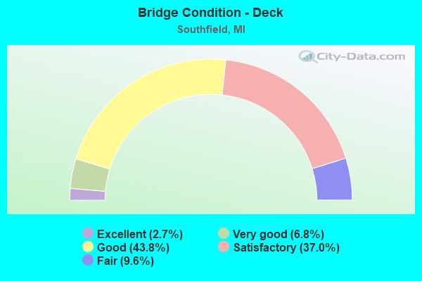
- Bridge Condition - Deck
- 2.7%Excellent
- 6.8%Very good
- 43.8%Good
- 37.0%Satisfactory
- 9.6%Fair
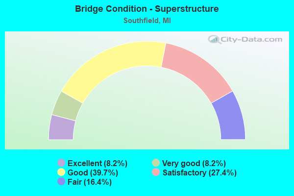
- Bridge Condition - Superstructure
- 8.2%Excellent
- 8.2%Very good
- 39.7%Good
- 27.4%Satisfactory
- 16.4%Fair
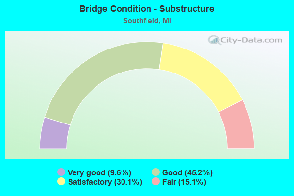
- Bridge Condition - Substructure
- 9.6%Very good
- 45.2%Good
- 30.1%Satisfactory
- 15.1%Fair
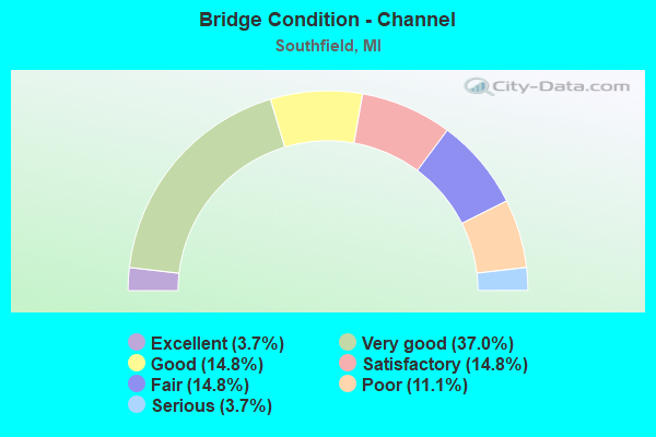
- Bridge Condition - Channel
- 3.7%Excellent
- 37.0%Very good
- 14.8%Good
- 14.8%Satisfactory
- 14.8%Fair
- 11.1%Poor
- 3.7%Serious
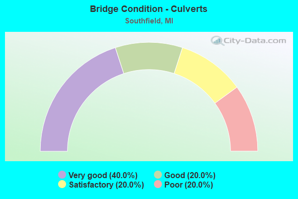
- Bridge Condition - Culverts
- 40.0%Very good
- 20.0%Good
- 20.0%Satisfactory
- 20.0%Poor
Find on map >> Show street view
Structure Number: 12736, Location: IN SOUTHFIELD (Lat: 42.456475, Lng: -83.315267), Route carried "on" structure: City street 2059, Year Built: 1930, Status: Open, Structure Length: 0.85m (2.79ft), Average Daily Traffic: 7,595 (year 2011), Truck Traffic: 2%, Average Future Daily Traffic: 7,822 (year 2013), Design Load: HS 20+Mod, Features Intersected: RAVINES BRANCH OF ROUGE, Facility Carried by Structure: NINE MILE ROAD
Minimum Vertical Clearance: 30.48m (100.00ft), Kilometerpoint: 0.182, Lanes on structure: 2, Owner: City or Municipal Highway Agency, Approaching Roadway Width: 12.2m (40.0ft), Material/Design: Concrete, Design/Construction: Culvert, Number Of Spans In Main Unit: 1, Length of Maximum Span: 8.0m (26.2ft)
Condition: Channel: Satisfactory, Culverts: Satisfactory, Operating Rating: 54.1 metric tons, Method Used To Determine Operating Rating: Load Factor (LF) rating reported by rating factor (RF) method using MS18 loading, Inventory Rating: 32.4 metric tons, Method Used To Determine Inventory Rating: Load Factor (LF) rating reported by rating factor (RF) method using MS18 loading, Structural Evaluation: Equal to present minimum criteria, Waterway Adequacy: Better than present minimum criteria, Approach Roadway Alignment: Equal to present minimum criteria, Length Of Structure Improvement: 1.60m (5.25ft), Designated Inspection Frequency: Every 24 months, Inspection Date: September 2021, Bridge Improvement Cost: $124,000, Total Project Cost: $161,000
Find on map >> Show street view
Structure Number: 13086, Location: N OF 8 MILE RD (Lat: 42.446267, Lng: -83.284264), Route carried "on" structure: City street , Year Built: 2001, Status: Open, Structure Length: 6.28m (20.60ft), Average Daily Traffic: 1,234 (year 2011), Truck Traffic: 3%, Average Future Daily Traffic: 1,271 (year 2013), Design Load: HS 25 or greater, Features Intersected: ROUGE RIVER, Facility Carried by Structure: BRIDGE STREET
Minimum Vertical Clearance: 30.48m (100.00ft), Kilometerpoint: 0.406, Lanes on structure: 1, Owner: City or Municipal Highway Agency, Approaching Roadway Width: 6.1m (20.0ft), Skew: 11 degrees, Material/Design: Prestressed concrete, Design/Construction: Tee Beam, Number Of Spans In Main Unit: 3, Length of Maximum Span: 20.5m (67.3ft), Curb or Sidewalk Widths: Left: 0.0m, Right: 1.5m (4.9ft), Curb-To-Curb Width: 6.1m (20.0ft), Out-to-Out Width: 8.5m (27.9ft)
Condition: Deck: Very good, Superstructure: Excellent, Substructure: Very good, Channel: Very good, Operating Rating: 54.8 metric tons, Method Used To Determine Operating Rating: Load and Resistance Factor Rating (LRFR) rating reported by rating factor(RF) method using HL-93 loadings, Inventory Rating: 42.4 metric tons, Method Used To Determine Inventory Rating: Load and Resistance Factor Rating (LRFR) rating reported by rating factor(RF) method using HL-93 loadings, Structural Evaluation: Equal to present desirable criteria, Deck Geometry: High priority of replacement, Waterway Adequacy: Superior to present desirable criteria, Approach Roadway Alignment: Equal to present desirable criteria, Designated Inspection Frequency: Every 24 months, Inspection Date: September 2021, Deck Structure Type: Concrete Cast-file-Place, Wearing Surface/Protective System: Wearing Surface: Monolithic Concrete, Deck Protection: Epoxy Coated Reinforcing
Find on map >> Show street view
Structure Number: 13497, Location: IN SOUTHFIELD (Lat: 42.457325, Lng: -83.317536), Route carried "on" structure: City street , Year Built: 1970, Status: Open, Structure Length: 1.01m (3.31ft), Average Daily Traffic: 7,324 (year 2011), Truck Traffic: 1%, Average Future Daily Traffic: 7,544 (year 2013), Features Intersected: ROUGE RIVER, Facility Carried by Structure: INKSTER ROAD
Minimum Vertical Clearance: 30.48m (100.00ft), Kilometerpoint: 1.719, Lanes on structure: 2, Owner: City or Municipal Highway Agency, Approaching Roadway Width: 7.9m (25.9ft), Material/Design: Steel, Design/Construction: Culvert, Number Of Spans In Main Unit: 2, Length of Maximum Span: 4.4m (14.4ft), Curb-To-Curb Width: 10.4m (34.1ft), Out-to-Out Width: 14.8m (48.6ft)
Condition: Channel: Poor, Culverts: Poor, Operating Rating: 54.1 metric tons, Method Used To Determine Operating Rating: Load Factor (LF) rating reported by rating factor (RF) method using MS18 loading, Inventory Rating: 32.4 metric tons, Method Used To Determine Inventory Rating: Load Factor (LF) rating reported by rating factor (RF) method using MS18 loading, Structural Evaluation: Meets minimum limits, Deck Geometry: Meets minimum limits, Waterway Adequacy: Better than present minimum criteria, Approach Roadway Alignment: Equal to present minimum criteria, Length Of Structure Improvement: 1.83m (6.00ft), Designated Inspection Frequency: Every 18 months, Inspection Date: March 2021, Bridge Improvement Cost: $1,110,000, Roadway Improvement Cost: $320,000, Total Project Cost: $1,855,000, Wearing Surface/Protective System: Wearing Surface: Bituminous
Find on map >> Show street view
Structure Number: 7872, Location: 0.75 MILES N OF M-102 (Lat: 42.451678, Lng: -83.211083), Route carried "under" structure: State highway 10, Year Built: 1964, Structure Length: 0. m, Average Daily Traffic: 69,400 (year 2007), Truck Traffic: 4%, Features Intersected: M-10, Facility Carried by Structure: J L HUDSON DRIVE
Minimum Vertical Clearance: 4.65m (15.26ft), Kilometerpoint: 15.212, Lanes on structure: 4, Lanes under structure: 6, Material/Design: Steel, Design/Construction: Stringer/Multi-beam, Length of Maximum Span: 18.2m (59.7ft)
Find on map >> Show street view
Structure Number: 7873, Location: IN SOUTHFIELD (RAMP G) (Lat: 42.456264, Lng: -83.218608), Route carried "under" structure: Ramp State highway 10, Year Built: 1964, Structure Length: 0. m, Average Daily Traffic: 8,350 (year 1977), Features Intersected: M-10 WB (RAMP G), Facility Carried by Structure: M-39 (RAMP H)
Minimum Vertical Clearance: 5.16m (16.93ft), Kilometerpoint: 0.209, Lanes on structure: 3, Lanes under structure: 1, Material/Design: Steel, Design/Construction: Stringer/Multi-beam, Length of Maximum Span: 20.3m (66.6ft)
Find on map >> Show street view
Structure Number: 7874, Location: IN SOUTHFIELD (RAMP A) (Lat: 42.456961, Lng: -83.217878), Route carried "under" structure: Ramp State highway 10, Year Built: 1964, Structure Length: 0. m, Average Daily Traffic: 2,200 (year 0000), Features Intersected: M-10 RAMP
Minimum Vertical Clearance: 4.65m (15.26ft), Kilometerpoint: 0.135, Lanes on structure: 2, Lanes under structure: 1, Material/Design: Steel, Design/Construction: Stringer/Multi-beam, Length of Maximum Span: 23.5m (77.1ft)
Find on map >> Show street view
Structure Number: 7875, Location: IN SOUTHFIELD RAMP H (Lat: 42.456683, Lng: -83.219650), Route carried "under" structure: State highway 39, Year Built: 1964, Structure Length: 0. m, Average Daily Traffic: 90,482 (year 2007), Truck Traffic: 5%, Features Intersected: M-39, Facility Carried by Structure: M-10 RAMP H
Minimum Vertical Clearance: 4.78m (15.68ft), Kilometerpoint: 1.392, Lanes on structure: 2, Lanes under structure: 3, Material/Design: Steel, Design/Construction: Stringer/Multi-beam, Length of Maximum Span: 17.2m (56.4ft)
Find on map >> Show street view
Structure Number: 7876, Location: IN SOUTHFIELD (Lat: 42.457667, Lng: -83.219411), Route carried "under" structure: State highway 10, Year Built: 1964, Structure Length: 0. m, Average Daily Traffic: 69,400 (year 2007), Truck Traffic: 2%, Features Intersected: M-10, Facility Carried by Structure: M-39 NB
Minimum Vertical Clearance: 5.74m (18.83ft), Kilometerpoint: 14.275, Lanes on structure: 3, Lanes under structure: 6, Material/Design: Steel, Design/Construction: Stringer/Multi-beam, Length of Maximum Span: 29.7m (97.4ft)
Find on map >> Show street view
Structure Number: 7877, Location: IN SOUTHFIELD (Lat: 42.458878, Lng: -83.219600), Route carried "under" structure: City street 2059, Year Built: 1998, Structure Length: 0. m, Average Daily Traffic: 1,510 (year 0000), Features Intersected: 9 MILE RD, Facility Carried by Structure: M-39 NB
Minimum Vertical Clearance: 4.70m (15.42ft), Kilometerpoint: 8.055, Lanes on structure: 5, Lanes under structure: 4, Material/Design: Prestressed concrete, Design/Construction: Box Beam or Girders - Single/Spread, Length of Maximum Span: 23.0m (75.5ft)
Find on map >> Show street view
Structure Number: 7878, Location: IN SOUTHFIELD (RAMP E) (Lat: 42.458792, Lng: -83.222278), Route carried "under" structure: Ramp State highway 10, Year Built: 1964, Structure Length: 0. m, Average Daily Traffic: 68,690 (year 1998), Truck Traffic: 3%, Features Intersected: M-10 RAMP, Facility Carried by Structure: 9 MI RD
Minimum Vertical Clearance: 4.70m (15.42ft), Kilometerpoint: 0.212, Lanes on structure: 5, Lanes under structure: 2, Material/Design: Steel, Design/Construction: Stringer/Multi-beam, Length of Maximum Span: 14.3m (46.9ft)
Find on map >> Show street view
Structure Number: 7879, Location: SOUTHFIELD (M-39 SB & US (Lat: 42.458825, Lng: -83.221217), Route carried "under" structure: State highway 10, Year Built: 1964, Structure Length: 0. m, Average Daily Traffic: 69,400 (year 2007), Truck Traffic: 4%, Features Intersected: M-10, Facility Carried by Structure: 9 MI RD
Minimum Vertical Clearance: 4.80m (15.75ft), Kilometerpoint: 14.052, Lanes on structure: 5, Lanes under structure: 4, Material/Design: Steel, Design/Construction: Stringer/Multi-beam, Length of Maximum Span: 23.4m (76.8ft)
Find on map >> Show street view
Structure Number: 788, Location: SOUTHFIELD (TOP LEVEL) (Lat: 42.458950, Lng: -83.221397), Route carried "under" structure: City street 2059, Year Built: 1964, Structure Length: 0. m, Average Daily Traffic: 1,510 (year 1974), Features Intersected: 9 MILE RD, Facility Carried by Structure: M-39 SB
Minimum Vertical Clearance: 4.50m (14.76ft), Kilometerpoint: 13.962, Lanes on structure: 3, Lanes under structure: 4, Material/Design: Steel, Design/Construction: Stringer/Multi-beam, Length of Maximum Span: 42.6m (139.8ft)
Find on map >> Show street view
Structure Number: 7881, Location: IN SOUTHFIELD (RAMP C) (Lat: 42.459919, Lng: -83.221272), Route carried "under" structure: Ramp State highway 39, Year Built: 1964, Structure Length: 0. m, Average Daily Traffic: 19,700 (year 1977), Truck Traffic: 2%, Features Intersected: M-10 RAMP C
Minimum Vertical Clearance: 4.65m (15.26ft), Kilometerpoint: 0.180, Lanes on structure: 3, Lanes under structure: 2, Material/Design: Steel, Design/Construction: Stringer/Multi-beam, Length of Maximum Span: 13.2m (43.3ft)
Find on map >> Show street view
Structure Number: 7882, Location: IN SOUTHFIELD (M-10) (Lat: 42.465175, Lng: -83.230672), Route carried "under" structure: State highway 10, Year Built: 1963, Structure Length: 0. m, Average Daily Traffic: 115,545 (year 2018), Truck Traffic: 1%, Features Intersected: M-10, Facility Carried by Structure: MOUNT VERNON ST
Minimum Vertical Clearance: 4.57m (14.99ft), Kilometerpoint: 13.010, Lanes on structure: 2, Lanes under structure: 6, Material/Design: Steel, Design/Construction: Stringer/Multi-beam, Length of Maximum Span: 18.6m (61.0ft)
Find on map >> Show street view
Structure Number: 7883, Location: IN SOUTHFIELD (Lat: 42.471775, Lng: -83.240447), Route carried "under" structure: State highway 10, Year Built: 1974, Structure Length: 0. m, Average Daily Traffic: 115,545 (year 2018), Truck Traffic: 1%, Features Intersected: M-10, Facility Carried by Structure: EVERGREEN RD (NB)
Minimum Vertical Clearance: 4.72m (15.49ft), Kilometerpoint: 11.955, Lanes on structure: 3, Lanes under structure: 6, Material/Design: Steel, Design/Construction: Stringer/Multi-beam, Length of Maximum Span: 26.8m (87.9ft)
Find on map >> Show street view
Structure Number: 7884, Location: IN SOUTHFIELD (Lat: 42.471556, Lng: -83.240439), Route carried "under" structure: State highway 10, Year Built: 1963, Structure Length: 0. m, Average Daily Traffic: 115,545 (year 2018), Truck Traffic: 1%, Features Intersected: M-10, Facility Carried by Structure: EVERGREEN RD (SB)
Minimum Vertical Clearance: 5.23m (17.16ft), Kilometerpoint: 11.929, Lanes on structure: 3, Lanes under structure: 6, Material/Design: Steel, Design/Construction: Stringer/Multi-beam, Length of Maximum Span: 26.8m (87.9ft)
Find on map >> Show street view
Structure Number: 7885, Location: IN SOUTHFIELD (Lat: 42.472861, Lng: -83.241956), Route carried "under" structure: State highway 10, Year Built: 1963, Structure Length: 0. m, Average Daily Traffic: 115,545 (year 2018), Truck Traffic: 1%, Features Intersected: M-10
Minimum Vertical Clearance: 5.13m (16.83ft), Kilometerpoint: 11.731, Lanes on structure: 4, Lanes under structure: 6, Material/Design: Steel, Design/Construction: Stringer/Multi-beam, Length of Maximum Span: 25.5m (83.7ft)
Find on map >> Show street view
Structure Number: 7886, Location: IN SOUTHFIELD (Lat: 42.479550, Lng: -83.251156), Route carried "under" structure: State highway 10, Year Built: 1989, Structure Length: 0. m, Average Daily Traffic: 105,800 (year 2007), Truck Traffic: 2%, Features Intersected: M-10
Minimum Vertical Clearance: 4.88m (16.01ft), Kilometerpoint: 10.674, Lanes on structure: 4, Lanes under structure: 6, Material/Design: Steel, Design/Construction: Stringer/Multi-beam, Length of Maximum Span: 26.8m (87.9ft)
Find on map >> Show street view
Structure Number: 7887, Location: IN SOUTHFIELD (Lat: 42.483483, Lng: -83.261211), Route carried "under" structure: State highway 10, Year Built: 1963, Structure Length: 0. m, Average Daily Traffic: 139,700 (year 2007), Truck Traffic: 2%, Features Intersected: M-10, Facility Carried by Structure: LAHSER RD
Minimum Vertical Clearance: 4.57m (14.99ft), Kilometerpoint: 9.771, Lanes on structure: 7, Lanes under structure: 6, Material/Design: Steel, Design/Construction: Stringer/Multi-beam, Length of Maximum Span: 20.7m (67.9ft)
Find on map >> Show street view
Structure Number: 7888, Location: IN SOUTHFIELD (Lat: 42.446686, Lng: -83.205092), Route carried "under" structure: State highway 10, Year Built: 1965, Structure Length: 0. m, Average Daily Traffic: 69,400 (year 2007), Truck Traffic: 4%, Features Intersected: M-10, Facility Carried by Structure: NORTHLAND DR EB
Minimum Vertical Clearance: 4.62m (15.16ft), Kilometerpoint: 15.951, Lanes on structure: 2, Lanes under structure: 10, Material/Design: Steel, Design/Construction: Stringer/Multi-beam, Length of Maximum Span: 18.9m (62.0ft)
Find on map >> Show street view
Structure Number: 7889, Location: IN SOUTHFIELD (Lat: 42.446894, Lng: -83.205308), Route carried "under" structure: State highway 10, Year Built: 1965, Structure Length: 0. m, Average Daily Traffic: 69,400 (year 2007), Truck Traffic: 4%, Features Intersected: M-10, Facility Carried by Structure: NORTHLAND DR WB
Minimum Vertical Clearance: 4.55m (14.93ft), Kilometerpoint: 15.922, Lanes on structure: 3, Lanes under structure: 10, Material/Design: Steel, Design/Construction: Stringer/Multi-beam, Length of Maximum Span: 20.1m (65.9ft)
Find on map >> Show street view
Structure Number: 789, Location: IN SOUTHFIELD (Lat: 42.453000, Lng: -83.213028), Route carried "under" structure: State highway 10, Year Built: 1965, Structure Length: 0. m, Average Daily Traffic: 69,400 (year 2007), Truck Traffic: 2%, Features Intersected: M-10, Facility Carried by Structure: LEFT TURN STRUCT
Minimum Vertical Clearance: 4.75m (15.58ft), Kilometerpoint: 14.996, Lanes on structure: 1, Lanes under structure: 6, Material/Design: Steel, Design/Construction: Stringer/Multi-beam, Length of Maximum Span: 17.0m (55.8ft)
Find on map >> Show street view
Structure Number: 7891, Location: IN SOUTHFIELD (Lat: 42.488228, Lng: -83.284561), Route carried "under" structure: State highway 10, Year Built: 1964, Structure Length: 0. m, Average Daily Traffic: 69,850 (year 2007), Truck Traffic: 1%, Features Intersected: M-10 SB, Facility Carried by Structure: US-24
Minimum Vertical Clearance: 4.90m (16.08ft), Kilometerpoint: 7.748, Lanes on structure: 6, Lanes under structure: 5, Material/Design: Steel, Design/Construction: Stringer/Multi-beam, Length of Maximum Span: 26.2m (86.0ft)
Find on map >> Show street view
Structure Number: 7892, Location: IN SOUTHFIELD (Lat: 42.491542, Lng: -83.284706), Route carried "under" structure: US 24, Year Built: 1964, Structure Length: 0. m, Average Daily Traffic: 139,700 (year 2007), Truck Traffic: 2%, Features Intersected: US-24, Facility Carried by Structure: M-10 WB
Minimum Vertical Clearance: 4.65m (15.26ft), Kilometerpoint: 5.527, Lanes on structure: 6, Lanes under structure: 6, Material/Design: Steel, Design/Construction: Stringer/Multi-beam, Length of Maximum Span: 33.8m (110.9ft)
Find on map >> Show street view
Structure Number: 7905, Location: IN SOUTHFIELD (Lat: 42.490633, Lng: -83.319025), Route carried "under" structure: City street 2059, Year Built: 1988, Structure Length: 0. m, Average Daily Traffic: 14,850 (year 2008), Features Intersected: INKSTER RD, Facility Carried by Structure: I-696 EB
Minimum Vertical Clearance: 4.32m (14.17ft), Kilometerpoint: 5.419, Lanes on structure: 4, Lanes under structure: 2, Material/Design: Steel, Design/Construction: Stringer/Multi-beam, Length of Maximum Span: 36.6m (120.1ft)
Find on map >> Show street view
Structure Number: 7906, Location: IN SOUTHFIELD (Lat: 42.490825, Lng: -83.319042), Route carried "under" structure: City street 2059, Year Built: 1988, Structure Length: 0. m, Average Daily Traffic: 14,850 (year 2008), Features Intersected: INKSTER RD, Facility Carried by Structure: I-696 WB
Minimum Vertical Clearance: 4.29m (14.07ft), Kilometerpoint: 5.441, Lanes on structure: 4, Lanes under structure: 2, Material/Design: Steel, Design/Construction: Stringer/Multi-beam, Length of Maximum Span: 36.6m (120.1ft)
Find on map >> Show street view
Structure Number: 7907, Location: IN SOUTHFIELD (Lat: 42.493442, Lng: -83.299589), Route carried "under" structure: Interstate 696, Year Built: 2006, Structure Length: 0. m, Average Daily Traffic: 158,700 (year 2007), Truck Traffic: 6%, Features Intersected: I-696, Facility Carried by Structure: FRANKLIN RD
Minimum Vertical Clearance: 5.38m (17.65ft), Kilometerpoint: 12.429, Lanes on structure: 2, Lanes under structure: 8, Material/Design: Prestressed concrete, Design/Construction: Stringer/Multi-beam, Length of Maximum Span: 44.2m (145.0ft)
Find on map >> Show street view
Structure Number: 7908, Location: IN SOUTHFIELD (I-696) (Lat: 42.494358, Lng: -83.295306), Route carried "under" structure: Interstate 696, Year Built: 1964, Structure Length: 0. m, Average Daily Traffic: 158,700 (year 2007), Truck Traffic: 10%, Features Intersected: I-696, Facility Carried by Structure: M-10 SB NWESTERN
Minimum Vertical Clearance: 5.74m (18.83ft), Kilometerpoint: 12.798, Lanes on structure: 3, Lanes under structure: 5, Material/Design: Steel, Design/Construction: Stringer/Multi-beam, Length of Maximum Span: 44.6m (146.3ft)
Find on map >> Show street view
Structure Number: 7909, Location: IN SOUTHFIELD (I-696) (Lat: 42.490181, Lng: -83.285358), Route carried "under" structure: Interstate 696, Year Built: 1967, Structure Length: 0. m, Average Daily Traffic: 98,076 (year 2007), Truck Traffic: 10%, Features Intersected: I-696, Facility Carried by Structure: RAMP P TO M-10
Minimum Vertical Clearance: 5.49m (18.01ft), Kilometerpoint: 13.768, Lanes on structure: 1, Lanes under structure: 6, Material/Design: Steel, Design/Construction: Stringer/Multi-beam, Length of Maximum Span: 18.6m (61.0ft)
Find on map >> Show street view
Structure Number: 791, Location: IN SOUTHFIELD (I-696) (Lat: 42.489858, Lng: -83.284575), Route carried "under" structure: Interstate 696, Year Built: 1967, Structure Length: 0. m, Average Daily Traffic: 122,300 (year 2007), Truck Traffic: 7%, Features Intersected: I-696, Facility Carried by Structure: US-24,TELEGRAPH RD
Minimum Vertical Clearance: 5.56m (18.24ft), Kilometerpoint: 13.850, Lanes on structure: 6, Lanes under structure: 6, Material/Design: Steel, Design/Construction: Stringer/Multi-beam, Length of Maximum Span: 21.6m (70.9ft)
Find on map >> Show street view
Structure Number: 7911, Location: IN SOUTHFIELD (I-696) (Lat: 42.489650, Lng: -83.284075), Route carried "under" structure: Interstate 696, Year Built: 1967, Structure Length: 0. m, Average Daily Traffic: 122,300 (year 2007), Truck Traffic: 7%, Features Intersected: I-696, Facility Carried by Structure: US-24 N TO M-10 W
Minimum Vertical Clearance: 6.50m (21.33ft), Kilometerpoint: 13.889, Lanes on structure: 1, Lanes under structure: 6, Material/Design: Steel, Design/Construction: Stringer/Multi-beam, Length of Maximum Span: 19.4m (63.6ft)
Find on map >> Show street view
Structure Number: 7912, Location: IN SOUTHFIELD (Lat: 42.492567, Lng: -83.287381), Route carried "under" structure: Ramp Interstate 696, Year Built: 1964, Structure Length: 0. m, Average Daily Traffic: 3,500 (year 1977), Features Intersected: I-696 RAMP D, Facility Carried by Structure: M-10 NWESTERN HWY
Minimum Vertical Clearance: 4.57m (14.99ft), Kilometerpoint: 0.138, Lanes on structure: 5, Lanes under structure: 1, Material/Design: Prestressed concrete, Design/Construction: Box Beam or Girders - Single/Spread, Length of Maximum Span: 10.6m (34.8ft)
Find on map >> Show street view
Structure Number: 7915, Location: IN SOUTHFIELD (Lat: 42.485892, Lng: -83.209061), Route carried "under" structure: Interstate 696, Year Built: 1986, Structure Length: 0. m, Average Daily Traffic: 180,660 (year 2007), Truck Traffic: 5%, Features Intersected: I-696, Facility Carried by Structure: MEADOWOOD
Minimum Vertical Clearance: 5.79m (19.00ft), Kilometerpoint: 20.238, Lanes under structure: 8, Material/Design: Prestressed concrete, Design/Construction: Stringer/Multi-beam, Length of Maximum Span: 32.9m (107.9ft)
Find on map >> Show street view
Structure Number: 7917, Location: IN SOUTHFIELD (Lat: 42.487211, Lng: -83.281792), Route carried "under" structure: State highway 10, Year Built: 1967, Structure Length: 0. m, Average Daily Traffic: 69,850 (year 2007), Truck Traffic: 1%, Features Intersected: M-10 SB, Facility Carried by Structure: US-24 NB TO 696 EB
Minimum Vertical Clearance: 4.80m (15.75ft), Kilometerpoint: 8.002, Lanes on structure: 1, Lanes under structure: 4, Material/Design: Steel, Design/Construction: Stringer/Multi-beam, Length of Maximum Span: 25.4m (83.3ft)
Find on map >> Show street view
Structure Number: 7918, Location: IN SOUTHFIELD (Lat: 42.485467, Lng: -83.266747), Route carried "under" structure: State highway 10, Year Built: 1967, Structure Length: 0. m, Average Daily Traffic: 139,700 (year 2007), Truck Traffic: 1%, Features Intersected: M-10, Facility Carried by Structure: I-696
Minimum Vertical Clearance: 4.80m (15.75ft), Kilometerpoint: 9.169, Lanes on structure: 6, Lanes under structure: 4, Material/Design: Steel, Design/Construction: Stringer/Multi-beam, Length of Maximum Span: 47.8m (156.8ft)
Find on map >> Show street view
Structure Number: 7919, Location: CITY OF SOUTHFIELD (Lat: 42.485519, Lng: -83.261303), Route carried "under" structure: Interstate 696, Year Built: 1984, Structure Length: 0. m, Average Daily Traffic: 168,000 (year 2007), Truck Traffic: 5%, Features Intersected: I-696, Facility Carried by Structure: LAHSER ROAD
Minimum Vertical Clearance: 5.51m (18.08ft), Kilometerpoint: 15.870, Lanes on structure: 5, Lanes under structure: 8, Material/Design: Prestressed concrete, Design/Construction: Stringer/Multi-beam, Length of Maximum Span: 31.4m (103.0ft)
Find on map >> Show street view
Structure Number: 792, Location: 0.4 MI EAST OF LASHER (Lat: 42.486600, Lng: -83.252581), Route carried "under" structure: Interstate 696, Year Built: 1985, Structure Length: 0. m, Average Daily Traffic: 168,000 (year 2007), Truck Traffic: 5%, Features Intersected: I-696, Facility Carried by Structure: 11 MILE ROAD
Minimum Vertical Clearance: 5.28m (17.32ft), Kilometerpoint: 16.601, Lanes on structure: 2, Lanes under structure: 8, Material/Design: Steel continuous, Design/Construction: Stringer/Multi-beam, Length of Maximum Span: 57.9m (190.0ft)
Find on map >> Show street view
Structure Number: 7921, Location: IN SOUTHFIELD (Lat: 42.487192, Lng: -83.241186), Route carried "under" structure: Interstate 696, Year Built: 1985, Structure Length: 0. m, Average Daily Traffic: 178,100 (year 2007), Truck Traffic: 5%, Features Intersected: I-696, Facility Carried by Structure: EVERGREEN ROAD
Minimum Vertical Clearance: 6.10m (20.01ft), Kilometerpoint: 17.541, Lanes on structure: 7, Lanes under structure: 6, Material/Design: Prestressed concrete, Design/Construction: Stringer/Multi-beam, Length of Maximum Span: 19.8m (65.0ft)
Find on map >> Show street view
Structure Number: 7926, Location: IN SOUTHFIELD (Lat: 42.487681, Lng: -83.212522), Route carried "under" structure: Interstate 696, Year Built: 1987, Structure Length: 0. m, Average Daily Traffic: 180,660 (year 2007), Truck Traffic: 5%, Features Intersected: I-696, Facility Carried by Structure: E B 11 MILE SER RO
Minimum Vertical Clearance: 59.89m (196.49ft), Kilometerpoint: 19.879, Lanes on structure: 2, Lanes under structure: 6, Material/Design: Steel continuous, Design/Construction: Stringer/Multi-beam, Length of Maximum Span: 45.6m (149.6ft)
Find on map >> Show street view
Structure Number: 7927, Location: CITY OF SOUTHFIELD (Lat: 42.480997, Lng: -83.207081), Route carried "under" structure: Interstate 696, Year Built: 1987, Structure Length: 0. m, Average Daily Traffic: 180,660 (year 2007), Truck Traffic: 5%, Features Intersected: I-696, Facility Carried by Structure: LINCOLN DRIVE
Minimum Vertical Clearance: 6.07m (19.91ft), Kilometerpoint: 20.800, Lanes on structure: 2, Lanes under structure: 10, Material/Design: Prestressed concrete, Design/Construction: Stringer/Multi-beam, Length of Maximum Span: 28.0m (91.9ft)
Find on map >> Show street view
Structure Number: 7928, Location: CITY OF SOUTHFIELD (Lat: 42.477461, Lng: -83.203150), Route carried "under" structure: Interstate 696, Year Built: 1987, Structure Length: 0. m, Average Daily Traffic: 180,660 (year 2007), Truck Traffic: 5%, Features Intersected: I-696, Facility Carried by Structure: U-TURN W.OF GRNFLD
Minimum Vertical Clearance: 5.79m (19.00ft), Kilometerpoint: 21.352, Lanes on structure: 2, Lanes under structure: 8, Material/Design: Prestressed concrete, Design/Construction: Stringer/Multi-beam, Length of Maximum Span: 23.7m (77.8ft)
Find on map >> Show street view
Structure Number: 7929, Location: 1/4 MI.N. OF 10 MILE (Lat: 42.476939, Lng: -83.201872), Route carried "under" structure: Interstate 696, Year Built: 1987, Structure Length: 0. m, Average Daily Traffic: 188,900 (year 2007), Truck Traffic: 4%, Features Intersected: I-696, Facility Carried by Structure: GREENFIELD ROAD
Minimum Vertical Clearance: 5.84m (19.16ft), Kilometerpoint: 21.482, Lanes on structure: 6, Lanes under structure: 8, Material/Design: Prestressed concrete, Design/Construction: Stringer/Multi-beam, Length of Maximum Span: 24.6m (80.7ft)
Find on map >> Show street view
Structure Number: 793, Location: IN ROYAL OAK TOWNSHIP (Lat: 42.477008, Lng: -83.200589), Route carried "under" structure: Interstate 696, Year Built: 1987, Structure Length: 0. m, Average Daily Traffic: 188,900 (year 2007), Truck Traffic: 4%, Features Intersected: I-696, Facility Carried by Structure: U-TURN E.OF GRNFLD
Minimum Vertical Clearance: 5.66m (18.57ft), Kilometerpoint: 0.000, Lanes on structure: 2, Lanes under structure: 8, Material/Design: Prestressed concrete, Design/Construction: Stringer/Multi-beam, Length of Maximum Span: 23.7m (77.8ft)
Find on map >> Show street view
Structure Number: 7945, Location: 0.2 MI EAST OF LASHER (Lat: 42.485561, Lng: -83.257800), Route carried "under" structure: Interstate 696, Year Built: 1985, Structure Length: 0. m, Average Daily Traffic: 168,000 (year 2007), Truck Traffic: 5%, Features Intersected: I-696, Facility Carried by Structure: CORPORATE DR
Minimum Vertical Clearance: 5.69m (18.67ft), Kilometerpoint: 16.158, Lanes on structure: 2, Lanes under structure: 6, Material/Design: Prestressed concrete, Design/Construction: Stringer/Multi-beam, Length of Maximum Span: 36.9m (121.1ft)
Find on map >> Show street view
Structure Number: 7946, Location: SOUTHFIELD,W/CENT PK BLVD (Lat: 42.486842, Lng: -83.249425), Route carried "under" structure: Interstate 696, Year Built: 1987, Structure Length: 0. m, Average Daily Traffic: 168,000 (year 2007), Truck Traffic: 5%, Features Intersected: I-696, Facility Carried by Structure: HARVARD
Minimum Vertical Clearance: 5.21m (17.09ft), Kilometerpoint: 16.863, Lanes on structure: 2, Lanes under structure: 8, Material/Design: Prestressed concrete, Design/Construction: Stringer/Multi-beam, Length of Maximum Span: 29.3m (96.1ft)
Find on map >> Show street view
Structure Number: 7947, Location: IN SOUTHFIELD (Lat: 42.487111, Lng: -83.244664), Route carried "under" structure: Interstate 696, Year Built: 1986, Structure Length: 0. m, Average Daily Traffic: 168,000 (year 2007), Truck Traffic: 5%, Features Intersected: I-696, Facility Carried by Structure: CENTRAL PARK BLVD
Minimum Vertical Clearance: 5.26m (17.26ft), Kilometerpoint: 17.256, Lanes on structure: 2, Lanes under structure: 4, Material/Design: Prestressed concrete, Design/Construction: Stringer/Multi-beam, Length of Maximum Span: 19.8m (65.0ft)
Find on map >> Show street view
Structure Number: 7948, Location: 0.1 M W OF EVERGREEN (Lat: 42.487336, Lng: -83.242878), Route carried "under" structure: Interstate 696, Year Built: 1986, Structure Length: 0. m, Average Daily Traffic: 168,000 (year 2007), Truck Traffic: 5%, Features Intersected: I-696, Facility Carried by Structure: MEADOWLARK U EAST
Minimum Vertical Clearance: 5.38m (17.65ft), Kilometerpoint: 17.402, Lanes on structure: 2, Lanes under structure: 6, Material/Design: Prestressed concrete, Design/Construction: Stringer/Multi-beam, Length of Maximum Span: 19.8m (65.0ft)
Find on map >> Show street view
Structure Number: 7949, Location: E OF EVERGREEN (Lat: 42.487428, Lng: -83.239533), Route carried "under" structure: Interstate 696, Year Built: 1987, Structure Length: 0. m, Average Daily Traffic: 178,100 (year 2007), Truck Traffic: 5%, Features Intersected: I-696, Facility Carried by Structure: RED RIVER AVE U-T
Minimum Vertical Clearance: 5.59m (18.34ft), Kilometerpoint: 17.678, Lanes on structure: 4, Lanes under structure: 6, Material/Design: Prestressed concrete, Design/Construction: Stringer/Multi-beam, Length of Maximum Span: 19.8m (65.0ft)
Find on map >> Show street view
Structure Number: 795, Location: IN LATHRUP VILLAGE (Lat: 42.487592, Lng: -83.230514), Route carried "under" structure: Interstate 696, Year Built: 1987, Structure Length: 0. m, Average Daily Traffic: 178,100 (year 2007), Truck Traffic: 5%, Features Intersected: I-696, Facility Carried by Structure: SANTA BARBARA U EA
Minimum Vertical Clearance: 5.28m (17.32ft), Kilometerpoint: 18.420, Lanes on structure: 1, Lanes under structure: 6, Material/Design: Prestressed concrete, Design/Construction: Stringer/Multi-beam, Length of Maximum Span: 23.5m (77.1ft)
Find on map >> Show street view
Structure Number: 7994, Location: IN SOUTHFIELD (Lat: 42.451286, Lng: -83.219856), Route carried "under" structure: State highway 39, Year Built: 1963, Structure Length: 0. m, Average Daily Traffic: 90,482 (year 2007), Truck Traffic: 5%, Features Intersected: M-39, Facility Carried by Structure: CORNELL RD
Minimum Vertical Clearance: 4.57m (14.99ft), Kilometerpoint: 0.790, Lanes on structure: 3, Lanes under structure: 6, Material/Design: Prestressed concrete, Design/Construction: Stringer/Multi-beam, Length of Maximum Span: 16.4m (53.8ft)