Bridge Statistics for St. Louis, Michigan (MI)
Condition, Traffic, Stress, Structural Evaluation, Project Costs
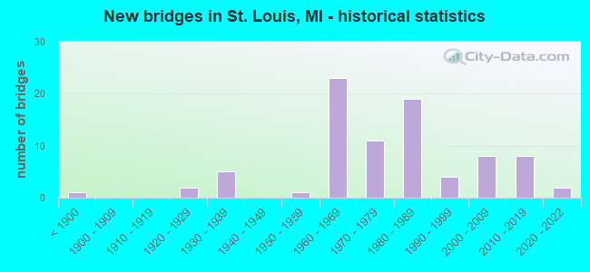
- New bridges - historical statistics
- 1Before 1900
- 21920-1929
- 51930-1939
- 11950-1959
- 231960-1969
- 111970-1979
- 191980-1989
- 41990-1999
- 82000-2009
- 82010-2019
- 22020-2022
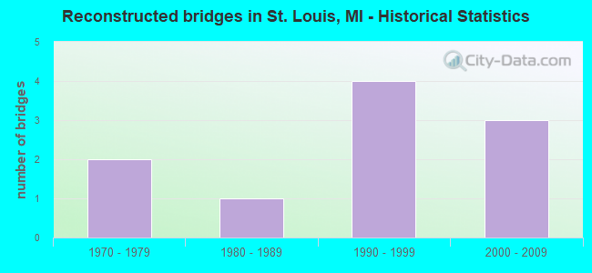
- Reconstructed bridges - Historical Statistics
- 21970-1979
- 11980-1989
- 41990-1999
- 32000-2009
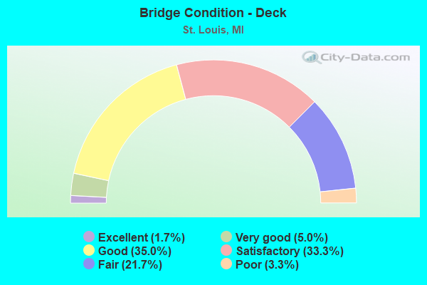
- Bridge Condition - Deck
- 1.7%Excellent
- 5.0%Very good
- 35.0%Good
- 33.3%Satisfactory
- 21.7%Fair
- 3.3%Poor

- Bridge Condition - Superstructure
- 3.3%Excellent
- 8.3%Very good
- 18.3%Good
- 28.3%Satisfactory
- 33.3%Fair
- 8.3%Poor
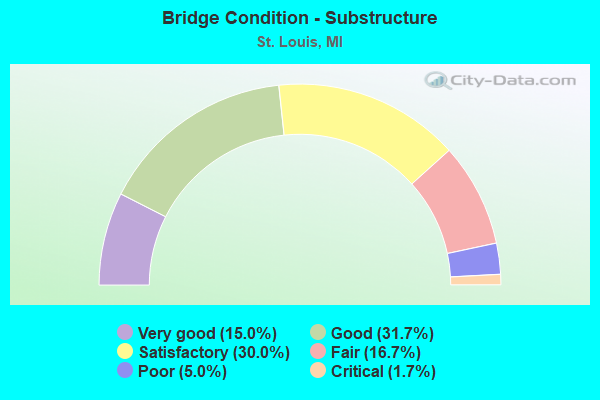
- Bridge Condition - Substructure
- 15.0%Very good
- 31.7%Good
- 30.0%Satisfactory
- 16.7%Fair
- 5.0%Poor
- 1.7%Critical
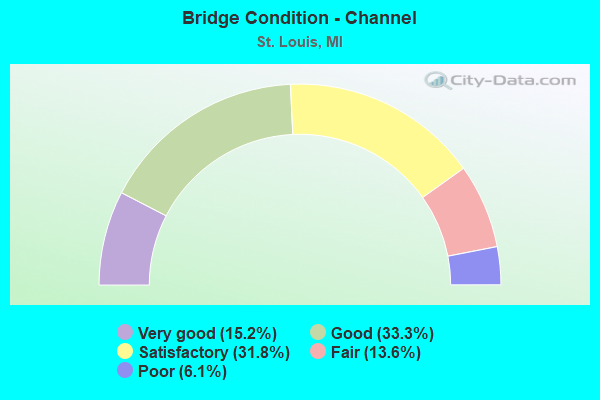
- Bridge Condition - Channel
- 15.2%Very good
- 33.3%Good
- 31.8%Satisfactory
- 13.6%Fair
- 6.1%Poor
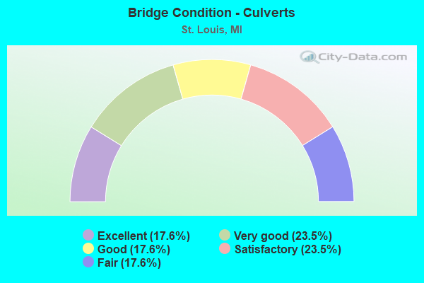
- Bridge Condition - Culverts
- 17.6%Excellent
- 23.5%Very good
- 17.6%Good
- 23.5%Satisfactory
- 17.6%Fair
Find on map >> Show street view
Structure Number: 10046, Location: SEC. 18 ST. CLAIR TWP. (Lat: 42.860267, Lng: -82.613481), Route carried "on" structure: County highway 7746, Year Built: 2021, Status: Open, Structure Length: 0.61m (2.00ft), Average Daily Traffic: 4,263 (year 2014), Truck Traffic: 14%, Average Future Daily Traffic: 6,335 (year 2034), Design Load: Greater than HL93, Features Intersected: UNNAMED CREEK, Facility Carried by Structure: GRATIOT ROAD
Minimum Vertical Clearance: 30.48m (100.00ft), Kilometerpoint: 12.275, Lanes on structure: 2, Owner: County Highway Agency, Approaching Roadway Width: 15.2m (49.9ft), Material/Design: Concrete, Design/Construction: Culvert, Number Of Spans In Main Unit: 1, Length of Maximum Span: 6.1m (20.0ft), Curb-To-Curb Width: 14.0m (45.9ft), Out-to-Out Width: 17.1m (56.1ft)
Condition: Channel: Good, Culverts: Excellent, Operating Rating: 48.6 metric tons, Method Used To Determine Operating Rating: Load and Resistance Factor Rating (LRFR) rating reported by rating factor(RF) method using HL-93 loadings, Inventory Rating: 35.6 metric tons, Method Used To Determine Inventory Rating: Load and Resistance Factor Rating (LRFR) rating reported by rating factor(RF) method using HL-93 loadings, Structural Evaluation: Superior to present desirable criteria, Deck Geometry: Superior to present desirable criteria, Waterway Adequacy: Equal to present minimum criteria, Approach Roadway Alignment: Equal to present desirable criteria, Length Of Structure Improvement: 1.83m (6.00ft), Designated Inspection Frequency: Every 24 months, Inspection Date: August 2021, Bridge Improvement Cost: $600,000, Roadway Improvement Cost: $150,000, Total Project Cost: $750,000, Wearing Surface/Protective System: Wearing Surface: Bituminous
Find on map >> Show street view
Structure Number: 10049, Location: SEC. 17 ST. CLAIR TWP. (Lat: 42.863519, Lng: -82.596689), Route carried "on" structure: County highway 7748, Year Built: 1977, Status: Open, Structure Length: 1.22m (4.00ft), Average Daily Traffic: 1,888 (year 2001), Truck Traffic: 5%, Average Future Daily Traffic: 3,400 (year 2021), Design Load: HS 20, Features Intersected: RATTLE RUN CREEK, Facility Carried by Structure: RATTLE RUN ROAD
Minimum Vertical Clearance: 30.48m (100.00ft), Kilometerpoint: 12.537, Lanes on structure: 2, Owner: County Highway Agency, Approaching Roadway Width: 10.4m (34.1ft), Material/Design: Prestressed concrete, Design/Construction: Tee Beam, Number Of Spans In Main Unit: 1, Length of Maximum Span: 11.0m (36.1ft), Curb-To-Curb Width: 10.1m (33.1ft), Out-to-Out Width: 10.9m (35.8ft)
Condition: Deck: Satisfactory, Superstructure: Fair, Substructure: Very good, Channel: Fair, Operating Rating: 60.9 metric tons, Method Used To Determine Operating Rating: Load Factor (LF) rating reported by rating factor (RF) method using MS18 loading, Inventory Rating: 36.6 metric tons, Method Used To Determine Inventory Rating: Load Factor (LF) rating reported by rating factor (RF) method using MS18 loading, Structural Evaluation: Somewhat better than minimum adequacy, Deck Geometry: Somewhat better than minimum adequacy, Waterway Adequacy: Superior to present desirable criteria, Approach Roadway Alignment: Equal to present minimum criteria, Designated Inspection Frequency: Every 24 months, Inspection Date: January 2022, Deck Structure Type: Concrete Cast-file-Place, Wearing Surface/Protective System: Wearing Surface: Bituminous, Membrane: Other
Find on map >> Show street view
Structure Number: 10059, Location: SEC. 22 WALES TWP. (Lat: 42.941050, Lng: -82.683175), Route carried "on" structure: County highway , Year Built: 2019, Status: Open, Structure Length: 1.10m (3.61ft), Average Daily Traffic: 483 (year 1994), Truck Traffic: 5%, Average Future Daily Traffic: 870 (year 2014), Design Load: Greater than HL93, Features Intersected: SPENCER DRAIN, Facility Carried by Structure: LAMBS ROAD
Minimum Vertical Clearance: 30.48m (100.00ft), Kilometerpoint: 3.875, Lanes on structure: 2, Owner: County Highway Agency, Approaching Roadway Width: 7.3m (24.0ft), Material/Design: Aluminum, Iron, Design/Construction: Culvert, Number Of Spans In Main Unit: 1, Length of Maximum Span: 7.7m (25.3ft), Curb-To-Curb Width: 9.1m (29.9ft), Out-to-Out Width: 9.1m (29.9ft)
Condition: Channel: Satisfactory, Culverts: Very good, Operating Rating: 45.7 metric tons, Method Used To Determine Operating Rating: Load and Resistance Factor Rating (LRFR) rating reported by rating factor(RF) method using HL-93 loadings, Inventory Rating: 33.0 metric tons, Method Used To Determine Inventory Rating: Load and Resistance Factor Rating (LRFR) rating reported by rating factor(RF) method using HL-93 loadings, Structural Evaluation: Equal to present desirable criteria, Deck Geometry: Equal to present minimum criteria, Waterway Adequacy: Equal to present minimum criteria, Approach Roadway Alignment: Equal to present minimum criteria, Designated Inspection Frequency: Every 24 months, Inspection Date: November 2021, Wearing Surface/Protective System: Wearing Surface: Bituminous
Find on map >> Show street view
Structure Number: 10062, Location: SEC. 7 KIMBALL TWP. (Lat: 42.968800, Lng: -82.619400), Route carried "on" structure: County highway 7768, Year Built: 1988, Status: Posted for load, Structure Length: 4.17m (13.68ft), Average Daily Traffic: 1,390 (year 2003), Truck Traffic: 4%, Average Future Daily Traffic: 2,510 (year 2023), Design Load: HS 20+Mod, Features Intersected: PINE RIVER, Facility Carried by Structure: SPARLING ROAD
Minimum Vertical Clearance: 30.48m (100.00ft), Kilometerpoint: 12.346, Lanes on structure: 2, Owner: County Highway Agency, Approaching Roadway Width: 10.4m (34.1ft), Material/Design: Concrete, Design/Construction: Tee Beam, Number Of Spans In Main Unit: 1, Number Of Approach Spans: 2, Length of Maximum Span: 13.0m (42.7ft), Curb-To-Curb Width: 11.2m (36.7ft), Out-to-Out Width: 11.9m (39.0ft)
Condition: Deck: Fair, Superstructure: Poor, Substructure: Fair, Channel: Satisfactory, Operating Rating: 51.5 metric tons, Method Used To Determine Operating Rating: Load Factor (LF) rating reported by rating factor (RF) method using MS18 loading, Inventory Rating: 30.8 metric tons, Method Used To Determine Inventory Rating: Load Factor (LF) rating reported by rating factor (RF) method using MS18 loading, Structural Evaluation: Meets minimum limits, Deck Geometry: Equal to present minimum criteria, Waterway Adequacy: Equal to present desirable criteria, Approach Roadway Alignment: Equal to present minimum criteria, Bridge Posting: Required (Relationship of Operating Rating to Maximum Legal Load: 10.0 - 19.9% below), Designated Inspection Frequency: Every 12 months, Inspection Date: December 2021, Deck Structure Type: Concrete Precast Panels, Wearing Surface/Protective System: Wearing Surface: Bituminous, Membrane: Preformed Fabric
Find on map >> Show street view
Structure Number: 10065, Location: SEC. 36 MUSSEY TWP. (Lat: 42.983969, Lng: -82.874875), Route carried "on" structure: County highway , Year Built: 1987, Status: Open, Structure Length: 1.52m (4.99ft), Average Daily Traffic: 555 (year 1994), Truck Traffic: 3%, Average Future Daily Traffic: 654 (year 2014), Design Load: HS 20+Mod, Features Intersected: COX-DOTY DRAIN, Facility Carried by Structure: BURT ROAD
Minimum Vertical Clearance: 30.48m (100.00ft), Kilometerpoint: 9.109, Lanes on structure: 2, Owner: County Highway Agency, Approaching Roadway Width: 8.5m (27.9ft), Skew: 3 degrees, Material/Design: Prestressed concrete, Design/Construction: Tee Beam, Number Of Spans In Main Unit: 2, Length of Maximum Span: 7.6m (24.9ft), Curb-To-Curb Width: 10.1m (33.1ft), Out-to-Out Width: 11.0m (36.1ft)
Condition: Deck: Satisfactory, Superstructure: Satisfactory, Substructure: Fair, Channel: Satisfactory, Operating Rating: 95.3 metric tons, Method Used To Determine Operating Rating: Load Factor (LF) rating reported by rating factor (RF) method using MS18 loading, Inventory Rating: 55.4 metric tons, Method Used To Determine Inventory Rating: Load Factor (LF) rating reported by rating factor (RF) method using MS18 loading, Structural Evaluation: Somewhat better than minimum adequacy, Deck Geometry: Equal to present minimum criteria, Waterway Adequacy: Better than present minimum criteria, Approach Roadway Alignment: Equal to present desirable criteria, Designated Inspection Frequency: Every 24 months, Inspection Date: November 2020, Deck Structure Type: Concrete Cast-file-Place, Wearing Surface/Protective System: Wearing Surface: Bituminous, Deck Protection: Epoxy Coated Reinforcing
Find on map >> Show street view
Structure Number: 10066, Location: SEC. 17 CLYDE TWP. (Lat: 43.044944, Lng: -82.613939), Route carried "on" structure: County highway 7773, Year Built: 1989, Status: Open, Structure Length: 2.21m (7.25ft), Average Daily Traffic: 960 (year 1994), Truck Traffic: 5%, Average Future Daily Traffic: 990 (year 2014), Design Load: HS 20+Mod, Features Intersected: MILL CREEK, Facility Carried by Structure: ABBOTSFORD ROAD
Minimum Vertical Clearance: 30.48m (100.00ft), Kilometerpoint: 7.688, Lanes on structure: 2, Owner: County Highway Agency, Approaching Roadway Width: 8.5m (27.9ft), Material/Design: Prestressed concrete, Design/Construction: Box Beam or Girders - Multiple, Number Of Spans In Main Unit: 1, Length of Maximum Span: 21.4m (70.2ft), Curb-To-Curb Width: 10.4m (34.1ft), Out-to-Out Width: 11.4m (37.4ft)
Condition: Deck: Good, Superstructure: Satisfactory, Substructure: Satisfactory, Channel: Satisfactory, Operating Rating: 69.7 metric tons, Method Used To Determine Operating Rating: Load Factor (LF) rating reported by rating factor (RF) method using MS18 loading, Inventory Rating: 13.3 metric tons, Method Used To Determine Inventory Rating: Load Factor (LF) rating reported by rating factor (RF) method using MS18 loading, Structural Evaluation: Meets minimum limits, Deck Geometry: Equal to present minimum criteria, Waterway Adequacy: Equal to present desirable criteria, Approach Roadway Alignment: Somewhat better than minimum adequacy, Designated Inspection Frequency: Every 24 months, Inspection Date: April 2021, Deck Structure Type: Concrete Cast-file-Place, Wearing Surface/Protective System: Wearing Surface: Bituminous
Find on map >> Show street view
Structure Number: 10067, Location: SEC. 17-18 KENOCKEE TWP (Lat: 43.031914, Lng: -82.733300), Route carried "on" structure: County highway , Year Built: 1979, Status: Posted for load, Structure Length: 0.70m (2.30ft), Average Daily Traffic: 195 (year 1994), Truck Traffic: 3%, Average Future Daily Traffic: 230 (year 2014), Design Load: HS 20+Mod, Features Intersected: WHACKENBUSH DRAIN, Facility Carried by Structure: BRICKER ROAD
Minimum Vertical Clearance: 30.48m (100.00ft), Kilometerpoint: 5.792, Lanes on structure: 2, Owner: County Highway Agency, Approaching Roadway Width: 7.3m (24.0ft), Material/Design: Steel, Design/Construction: Culvert, Number Of Spans In Main Unit: 2, Length of Maximum Span: 6.1m (20.0ft), Out-to-Out Width: 8.0m (26.2ft)
Condition: Channel: Satisfactory, Culverts: Fair, Operating Rating: 13.3 metric tons, Method Used To Determine Operating Rating: Load Factor (LF) rating reported by rating factor (RF) method using MS18 loading, Inventory Rating: 10.0 metric tons, Method Used To Determine Inventory Rating: Load Factor (LF) rating reported by rating factor (RF) method using MS18 loading, Structural Evaluation: High priority of corrective action, Waterway Adequacy: Better than present minimum criteria, Approach Roadway Alignment: Better than present minimum criteria, Bridge Posting: Required (Relationship of Operating Rating to Maximum Legal Load: 30.0 - 39.9% below), Designated Inspection Frequency: Every 24 months, Inspection Date: March 2021, Wearing Surface/Protective System: Wearing Surface: Gravel
Find on map >> Show street view
Structure Number: 10072, Location: SEC 27-34 LYNN TWP (Lat: 43.084011, Lng: -82.925033), Route carried "on" structure: County highway 7786, Year Built: 1975, Status: Open, Structure Length: 2.25m (7.38ft), Average Daily Traffic: 151 (year 1994), Truck Traffic: 3%, Average Future Daily Traffic: 162 (year 2014), Design Load: HS 20+Mod, Features Intersected: S BR MILL CREEK DRAIN, Facility Carried by Structure: NORMAN ROAD
Minimum Vertical Clearance: 30.48m (100.00ft), Kilometerpoint: 5.440, Lanes on structure: 2, Owner: County Highway Agency, Approaching Roadway Width: 6.1m (20.0ft), Skew: 4 degrees, Material/Design: Prestressed concrete, Design/Construction: Box Beam or Girders - Multiple, Number Of Spans In Main Unit: 5, Length of Maximum Span: 10.6m (34.8ft), Curb-To-Curb Width: 10.1m (33.1ft), Out-to-Out Width: 11.1m (36.4ft)
Condition: Deck: Good, Superstructure: Fair, Substructure: Good, Channel: Good, Operating Rating: 60.6 metric tons, Method Used To Determine Operating Rating: Load Factor (LF) rating reported by rating factor (RF) method using MS18 loading, Inventory Rating: 36.3 metric tons, Method Used To Determine Inventory Rating: Load Factor (LF) rating reported by rating factor (RF) method using MS18 loading, Structural Evaluation: Somewhat better than minimum adequacy, Deck Geometry: Better than present minimum criteria, Waterway Adequacy: Equal to present desirable criteria, Approach Roadway Alignment: Equal to present desirable criteria, Designated Inspection Frequency: Every 24 months, Inspection Date: November 2020, Roadway Improvement Cost: $5,000, Total Project Cost: $6,000, Deck Structure Type: Concrete Cast-file-Place, Wearing Surface/Protective System: Wearing Surface: Bituminous
Find on map >> Show street view
Structure Number: 10073, Location: SEC. 26-35 BROCKWAY TWP. (Lat: 43.086867, Lng: -82.777958), Route carried "on" structure: County highway 7786, Year Built: 1996, Status: Open, Structure Length: 10.67m (35.01ft), Average Daily Traffic: 250 (year 1995), Average Future Daily Traffic: 600 (year 2015), Design Load: HS 20, Features Intersected: MILL CREEK, Facility Carried by Structure: NORMAN ROAD
Minimum Vertical Clearance: 30.48m (100.00ft), Kilometerpoint: 17.422, Lanes on structure: 2, Owner: County Highway Agency, Approaching Roadway Width: 9.1m (29.9ft), Skew: 9 degrees, Material/Design: Prestressed concrete, Design/Construction: Stringer/Multi-beam, Number Of Spans In Main Unit: 5, Length of Maximum Span: 21.3m (69.9ft), Curb-To-Curb Width: 9.3m (30.5ft), Out-to-Out Width: 10.0m (32.8ft)
Condition: Deck: Good, Superstructure: Very good, Substructure: Satisfactory, Channel: Very good, Operating Rating: 82.6 metric tons, Method Used To Determine Operating Rating: Load Factor (LF) rating reported by rating factor (RF) method using MS18 loading, Inventory Rating: 48.3 metric tons, Method Used To Determine Inventory Rating: Load Factor (LF) rating reported by rating factor (RF) method using MS18 loading, Structural Evaluation: Equal to present minimum criteria, Deck Geometry: Equal to present minimum criteria, Waterway Adequacy: Equal to present desirable criteria, Approach Roadway Alignment: Equal to present minimum criteria, Designated Inspection Frequency: Every 24 months, Inspection Date: January 2021, Deck Structure Type: Concrete Cast-file-Place, Wearing Surface/Protective System: Wearing Surface: Monolithic Concrete, Deck Protection: Epoxy Coated Reinforcing
Find on map >> Show street view
Structure Number: 10082, Location: SEC. 15-16 LYNN TWP. (Lat: 43.114236, Lng: -82.933192), Route carried "on" structure: County highway 7707, Year Built: 2006, Status: Open, Structure Length: 2.29m (7.51ft), Average Daily Traffic: 2,050 (year 2005), Truck Traffic: 10%, Average Future Daily Traffic: 4,490 (year 2025), Design Load: HS 20, Features Intersected: N. BR. MILL CREEK DRAIN, Facility Carried by Structure: CAPAC ROAD
Minimum Vertical Clearance: 30.48m (100.00ft), Kilometerpoint: 25.630, Lanes on structure: 2, Owner: County Highway Agency, Approaching Roadway Width: 12.2m (40.0ft), Skew: 2 degrees, Material/Design: Prestressed concrete, Design/Construction: Box Beam or Girders - Multiple, Number Of Spans In Main Unit: 1, Length of Maximum Span: 21.3m (69.9ft), Curb-To-Curb Width: 12.5m (41.0ft), Out-to-Out Width: 13.3m (43.6ft)
Condition: Deck: Satisfactory, Superstructure: Good, Substructure: Very good, Channel: Good, Operating Rating: 97.2 metric tons, Method Used To Determine Operating Rating: Load Factor (LF) rating reported by rating factor (RF) method using MS18 loading, Inventory Rating: 54.8 metric tons, Method Used To Determine Inventory Rating: Load Factor (LF) rating reported by rating factor (RF) method using MS18 loading, Structural Evaluation: Better than present minimum criteria, Deck Geometry: Equal to present minimum criteria, Waterway Adequacy: Equal to present minimum criteria, Approach Roadway Alignment: Equal to present desirable criteria, Designated Inspection Frequency: Every 24 months, Inspection Date: November 2020, Deck Structure Type: Concrete Cast-file-Place, Wearing Surface/Protective System: Wearing Surface: Integral Concrete, Deck Protection: Epoxy Coated Reinforcing
Find on map >> Show street view
Structure Number: 10084, Location: SEC. 13-14 LYNN TWP. (Lat: 43.123314, Lng: -82.893944), Route carried "on" structure: County highway , Year Built: 1985, Year Reconstructed: 2011, Status: Open, Structure Length: 2.56m (8.40ft), Average Daily Traffic: 1,110 (year 1994), Truck Traffic: 7%, Average Future Daily Traffic: 1,420 (year 2014), Design Load: HL 93, Features Intersected: N. BR. MILL CREEK DRAIN, Facility Carried by Structure: MASON ROAD
Minimum Vertical Clearance: 30.48m (100.00ft), Kilometerpoint: 1.096, Lanes on structure: 2, Owner: County Highway Agency, Approaching Roadway Width: 9.7m (31.8ft), Material/Design: Wood or Timber, Design/Construction: Slab, Number Of Spans In Main Unit: 3, Length of Maximum Span: 8.5m (27.9ft), Curb-To-Curb Width: 12.2m (40.0ft), Out-to-Out Width: 12.8m (42.0ft)
Condition: Deck: Good, Superstructure: Good, Substructure: Fair, Channel: Very good, Operating Rating: 71.6 metric tons, Method Used To Determine Operating Rating: Load and Resistance Factor Rating (LRFR) rating reported by rating factor(RF) method using HL-93 loadings, Inventory Rating: 55.4 metric tons, Method Used To Determine Inventory Rating: Load and Resistance Factor Rating (LRFR) rating reported by rating factor(RF) method using HL-93 loadings, Structural Evaluation: Somewhat better than minimum adequacy, Deck Geometry: Better than present minimum criteria, Waterway Adequacy: Better than present minimum criteria, Approach Roadway Alignment: Equal to present minimum criteria, Designated Inspection Frequency: Every 24 months, Inspection Date: October 2021, Deck Structure Type: Wood or Timber, Wearing Surface/Protective System: Wearing Surface: Bituminous, Membrane: Other, Deck Protection: Epoxy Coated Reinforcing
Find on map >> Show street view
Structure Number: 10085, Location: SEC. 17-18 RILEY TWP. (Lat: 42.945586, Lng: -82.841969), Route carried "on" structure: County highway , Year Built: 2013, Status: Open, Structure Length: 2.74m (8.99ft), Average Daily Traffic: 2,130 (year 2012), Truck Traffic: 6%, Average Future Daily Traffic: 3,165 (year 2032), Design Load: Greater than HL93, Features Intersected: BELLE RIVER, Facility Carried by Structure: RILEY CENTER ROAD
Minimum Vertical Clearance: 30.48m (100.00ft), Kilometerpoint: 5.583, Lanes on structure: 2, Owner: County Highway Agency, Approaching Roadway Width: 12.2m (40.0ft), Skew: 1 degrees, Material/Design: Prestressed concrete, Design/Construction: Box Beam or Girders - Multiple, Number Of Spans In Main Unit: 1, Length of Maximum Span: 26.8m (87.9ft), Curb-To-Curb Width: 12.4m (40.7ft), Out-to-Out Width: 13.4m (44.0ft)
Condition: Deck: Good, Superstructure: Good, Substructure: Good, Channel: Fair, Operating Rating: 66.7 metric tons, Method Used To Determine Operating Rating: Load and Resistance Factor Rating (LRFR) rating reported by rating factor(RF) method using HL-93 loadings, Inventory Rating: 50.5 metric tons, Method Used To Determine Inventory Rating: Load and Resistance Factor Rating (LRFR) rating reported by rating factor(RF) method using HL-93 loadings, Structural Evaluation: Better than present minimum criteria, Deck Geometry: Equal to present minimum criteria, Waterway Adequacy: Somewhat better than minimum adequacy, Approach Roadway Alignment: Equal to present minimum criteria, Designated Inspection Frequency: Every 24 months, Inspection Date: November 2021, Deck Structure Type: Concrete Cast-file-Place, Wearing Surface/Protective System: Wearing Surface: Monolithic Concrete, Deck Protection: Epoxy Coated Reinforcing
Find on map >> Show street view
Structure Number: 10092, Location: SEC. 15 KENOCKEE TWP. (Lat: 43.042644, Lng: -82.693431), Route carried "on" structure: County highway 7747, Year Built: 1974, Status: Open, Structure Length: 7.31m (23.98ft), Average Daily Traffic: 1,095 (year 2017), Truck Traffic: 8%, Average Future Daily Traffic: 1,630 (year 2037), Design Load: HS 20+Mod, Features Intersected: MILL CREEK, Facility Carried by Structure: KILGORE ROAD
Minimum Vertical Clearance: 30.48m (100.00ft), Kilometerpoint: 7.154, Lanes on structure: 2, Owner: County Highway Agency, Approaching Roadway Width: 9.7m (31.8ft), Material/Design: Steel, Design/Construction: Stringer/Multi-beam, Number Of Spans In Main Unit: 3, Length of Maximum Span: 26.8m (87.9ft), Curb-To-Curb Width: 12.2m (40.0ft), Out-to-Out Width: 12.9m (42.3ft)
Condition: Deck: Good, Superstructure: Satisfactory, Substructure: Fair, Channel: Very good, Operating Rating: 62.2 metric tons, Method Used To Determine Operating Rating: Load Factor (LF) rating reported by rating factor (RF) method using MS18 loading, Inventory Rating: 37.3 metric tons, Method Used To Determine Inventory Rating: Load Factor (LF) rating reported by rating factor (RF) method using MS18 loading, Structural Evaluation: Somewhat better than minimum adequacy, Deck Geometry: Better than present minimum criteria, Waterway Adequacy: Equal to present desirable criteria, Approach Roadway Alignment: Equal to present minimum criteria, Length Of Structure Improvement: 2.29m (7.51ft), Designated Inspection Frequency: Every 24 months, Inspection Date: April 2021, Roadway Improvement Cost: $6,000, Total Project Cost: $7,000, Deck Structure Type: Concrete Cast-file-Place, Wearing Surface/Protective System: Wearing Surface: Monolithic Concrete
Find on map >> Show street view
Structure Number: 10173, Location: SEC. 10-11 GRANT TWP. (Lat: 43.152947, Lng: -82.563633), Route carried "on" structure: ServiceCounty highway , Year Built: 1980, Status: Open, Structure Length: 0.61m (2.00ft), Average Daily Traffic: 162 (year 1994), Truck Traffic: 3%, Average Future Daily Traffic: 185 (year 2014), Design Load: H 20, Features Intersected: BURTCH CREEK, Facility Carried by Structure: VINCENT ROAD
Minimum Vertical Clearance: 30.48m (100.00ft), Kilometerpoint: 1.642, Lanes on structure: 2, Owner: County Highway Agency, Approaching Roadway Width: 6.1m (20.0ft), Skew: 1 degrees, Material/Design: Steel, Design/Construction: Culvert, Number Of Spans In Main Unit: 1, Length of Maximum Span: 6.1m (20.0ft), Curb-To-Curb Width: 9.2m (30.2ft), Out-to-Out Width: 18.3m (60.0ft)
Condition: Channel: Satisfactory, Culverts: Very good, Operating Rating: 59.3 metric tons, Method Used To Determine Operating Rating: Load and Resistance Factor Rating (LRFR) rating reported by rating factor(RF) method using HL-93 loadings, Inventory Rating: 46.0 metric tons, Method Used To Determine Inventory Rating: Load and Resistance Factor Rating (LRFR) rating reported by rating factor(RF) method using HL-93 loadings, Structural Evaluation: Equal to present desirable criteria, Deck Geometry: Equal to present minimum criteria, Waterway Adequacy: Better than present minimum criteria, Approach Roadway Alignment: Equal to present minimum criteria, Designated Inspection Frequency: Every 24 months, Inspection Date: Febuary 2021
Find on map >> Show street view
Structure Number: 10185, Location: SEC. 3-10 IRA TWP. (Lat: 42.708467, Lng: -82.651608), Route carried "on" structure: ServiceCounty highway , Year Built: 1975, Status: Posted for load, Structure Length: 1.18m (3.87ft), Average Daily Traffic: 137 (year 2021), Truck Traffic: 6%, Average Future Daily Traffic: 204 (year 2041), Design Load: HS 20, Features Intersected: SWAN CREEK, Facility Carried by Structure: ARNOLD ROAD
Minimum Vertical Clearance: 30.48m (100.00ft), Kilometerpoint: 6.368, Lanes on structure: 2, Owner: County Highway Agency, Approaching Roadway Width: 6.1m (20.0ft), Material/Design: Prestressed concrete, Design/Construction: Box Beam or Girders - Multiple, Number Of Spans In Main Unit: 1, Length of Maximum Span: 10.3m (33.8ft), Curb-To-Curb Width: 6.4m (21.0ft), Out-to-Out Width: 6.4m (21.0ft)
Condition: Deck: Good, Superstructure: Satisfactory, Substructure: Satisfactory, Channel: Fair, Operating Rating: 53.5 metric tons, Method Used To Determine Operating Rating: Load Factor (LF) rating reported by rating factor (RF) method using MS18 loading, Inventory Rating: 30.5 metric tons, Method Used To Determine Inventory Rating: Load Factor (LF) rating reported by rating factor (RF) method using MS18 loading, Structural Evaluation: Equal to present minimum criteria, Deck Geometry: Meets minimum limits, Waterway Adequacy: Meets minimum limits, Approach Roadway Alignment: Equal to present minimum criteria, Bridge Posting: Required (Relationship of Operating Rating to Maximum Legal Load: 0.1 - 9.9% below), Length Of Structure Improvement: 3.45m (11.32ft), Designated Inspection Frequency: Every 24 months, Inspection Date: March 2020, Roadway Improvement Cost: $130,000, Total Project Cost: $14,000, Deck Structure Type: Concrete Cast-file-Place, Wearing Surface/Protective System: Wearing Surface: Bituminous
Find on map >> Show street view
Structure Number: 10186, Location: SEC. 2-3 IRA TWP. (Lat: 42.709253, Lng: -82.650442), Route carried "on" structure: ServiceCounty highway , Year Built: 2017, Status: Open, Structure Length: 1.35m (4.43ft), Average Daily Traffic: 150 (year 2017), Truck Traffic: 12%, Average Future Daily Traffic: 180 (year 2037), Design Load: Greater than HL93, Features Intersected: SWAN CREEK, Facility Carried by Structure: HESSEN ROAD
Minimum Vertical Clearance: 30.48m (100.00ft), Kilometerpoint: 0.082, Lanes on structure: 2, Owner: County Highway Agency, Approaching Roadway Width: 8.9m (29.2ft), Material/Design: Concrete, Design/Construction: Culvert, Number Of Spans In Main Unit: 1, Length of Maximum Span: 12.8m (42.0ft), Curb or Sidewalk Widths: Left: 0.8m (2.6ft), Right: 0.8m (2.6ft), Curb-To-Curb Width: 9.1m (29.9ft), Out-to-Out Width: 10.6m (34.8ft)
Condition: Channel: Good, Culverts: Very good, Operating Rating: 97.2 metric tons, Method Used To Determine Operating Rating: Load and Resistance Factor Rating (LRFR) rating reported by rating factor(RF) method using HL-93 loadings, Inventory Rating: 97.2 metric tons, Method Used To Determine Inventory Rating: Load and Resistance Factor Rating (LRFR) rating reported by rating factor(RF) method using HL-93 loadings, Structural Evaluation: Equal to present desirable criteria, Deck Geometry: Equal to present minimum criteria, Waterway Adequacy: Equal to present minimum criteria, Approach Roadway Alignment: Equal to present minimum criteria, Designated Inspection Frequency: Every 24 months, Inspection Date: October 2021, Wearing Surface/Protective System: Wearing Surface: Bituminous
Find on map >> Show street view
Structure Number: 10188, Location: SEC. 22 IRA TWP (Lat: 42.678231, Lng: -82.658486), Route carried "on" structure: ServiceCounty highway , Year Built: 1982, Status: Posted for load, Structure Length: 1.15m (3.77ft), Average Daily Traffic: 350 (year 2020), Truck Traffic: 5%, Average Future Daily Traffic: 425 (year 2040), Design Load: H 20, Features Intersected: UNNAMED CANAL, Facility Carried by Structure: LONG ISLAND COURT
Minimum Vertical Clearance: 30.48m (100.00ft), Kilometerpoint: 0.219, Lanes on structure: 2, Owner: County Highway Agency, Approaching Roadway Width: 6.1m (20.0ft), Material/Design: Wood or Timber, Design/Construction: Slab, Number Of Spans In Main Unit: 2, Length of Maximum Span: 5.7m (18.7ft), Curb-To-Curb Width: 5.8m (19.0ft), Out-to-Out Width: 6.3m (20.7ft)
Condition: Deck: Fair, Superstructure: Fair, Substructure: Critical, Channel: Satisfactory, Operating Rating: 48.6 metric tons, Method Used To Determine Operating Rating: Load Factor (LF) rating reported by rating factor (RF) method using MS18 loading, Inventory Rating: 35.6 metric tons, Method Used To Determine Inventory Rating: Load Factor (LF) rating reported by rating factor (RF) method using MS18 loading, Structural Evaluation: High priority of replacement, Deck Geometry: High priority of corrective action, Waterway Adequacy: Somewhat better than minimum adequacy, Approach Roadway Alignment: Somewhat better than minimum adequacy, Bridge Posting: Required (Relationship of Operating Rating to Maximum Legal Load: 10.0 - 19.9% below), Designated Inspection Frequency: Every 12 months, Underwater Inspection Frequency: Every 60 months, Inspection Date: March 2021, Underwater Inspection Date: October 2017, Deck Structure Type: Wood or Timber, Wearing Surface/Protective System: Wearing Surface: Bituminous
Find on map >> Show street view
Structure Number: 10191, Location: SEC 25-36 KENOCKEE TWP (Lat: 43.004756, Lng: -82.651728), Route carried "on" structure: ServiceCounty highway , Year Built: 2015, Status: Open, Structure Length: 0.82m (2.69ft), Average Daily Traffic: 75 (year 2015), Truck Traffic: 16%, Average Future Daily Traffic: 112 (year 2035), Design Load: Greater than HL93, Features Intersected: OLOUGHLIN DRAIN, Facility Carried by Structure: RYNN ROAD
Minimum Vertical Clearance: 30.48m (100.00ft), Kilometerpoint: 6.504, Lanes on structure: 2, Owner: County Highway Agency, Approaching Roadway Width: 9.1m (29.9ft), Skew: 2 degrees, Material/Design: Aluminum, Iron, Design/Construction: Culvert, Number Of Spans In Main Unit: 1, Length of Maximum Span: 8.2m (26.9ft), Curb-To-Curb Width: 9.1m (29.9ft), Out-to-Out Width: 15.1m (49.5ft)
Condition: Channel: Good, Culverts: Very good, Operating Rating: 72.9 metric tons, Method Used To Determine Operating Rating: Load and Resistance Factor Rating (LRFR) rating reported by rating factor(RF) method using HL-93 loadings, Inventory Rating: 56.1 metric tons, Method Used To Determine Inventory Rating: Load and Resistance Factor Rating (LRFR) rating reported by rating factor(RF) method using HL-93 loadings, Structural Evaluation: Equal to present desirable criteria, Deck Geometry: Better than present minimum criteria, Waterway Adequacy: Better than present minimum criteria, Approach Roadway Alignment: Equal to present desirable criteria, Designated Inspection Frequency: Every 24 months, Inspection Date: January 2022, Wearing Surface/Protective System: Wearing Surface: Bituminous
Find on map >> Show street view
Structure Number: 10194, Location: SEC 19 KENOCKEE TWP (Lat: 43.023333, Lng: -82.740756), Route carried "on" structure: ServiceCounty highway , Year Built: 1989, Status: Open, Structure Length: 0.88m (2.89ft), Average Daily Traffic: 51 (year 1994), Average Future Daily Traffic: 60 (year 2014), Design Load: HS 20+Mod, Features Intersected: SULLIVAN DRAIN, Facility Carried by Structure: BRENNAN ROAD
Minimum Vertical Clearance: 30.48m (100.00ft), Kilometerpoint: 0.652, Lanes on structure: 2, Owner: County Highway Agency, Approaching Roadway Width: 6.1m (20.0ft), Material/Design: Prestressed concrete, Design/Construction: Tee Beam, Number Of Spans In Main Unit: 1, Length of Maximum Span: 8.2m (26.9ft), Curb-To-Curb Width: 9.1m (29.9ft), Out-to-Out Width: 9.8m (32.2ft)
Condition: Deck: Good, Superstructure: Good, Substructure: Good, Channel: Satisfactory, Operating Rating: 77.4 metric tons, Method Used To Determine Operating Rating: Load Factor (LF) rating reported by rating factor (RF) method using MS18 loading, Inventory Rating: 46.3 metric tons, Method Used To Determine Inventory Rating: Load Factor (LF) rating reported by rating factor (RF) method using MS18 loading, Structural Evaluation: Better than present minimum criteria, Deck Geometry: Better than present minimum criteria, Waterway Adequacy: Better than present minimum criteria, Approach Roadway Alignment: Better than present minimum criteria, Designated Inspection Frequency: Every 24 months, Inspection Date: March 2021, Deck Structure Type: Concrete Cast-file-Place, Wearing Surface/Protective System: Wearing Surface: Bituminous
Find on map >> Show street view
Structure Number: 10198, Location: SEC. 19-20 KENOCKEE TWP. (Lat: 43.021983, Lng: -82.732694), Route carried "on" structure: ServiceCounty highway , Year Built: 2000, Status: Open, Structure Length: 1.05m (3.44ft), Average Daily Traffic: 211 (year 1999), Truck Traffic: 3%, Average Future Daily Traffic: 450 (year 2019), Design Load: HS 20, Features Intersected: SULLIVAN DRAIN, Facility Carried by Structure: BRICKER ROAD
Minimum Vertical Clearance: 30.48m (100.00ft), Kilometerpoint: 4.688, Lanes on structure: 2, Owner: County Highway Agency, Approaching Roadway Width: 9.6m (31.5ft), Material/Design: Prestressed concrete, Design/Construction: Box Beam or Girders - Multiple, Number Of Spans In Main Unit: 1, Length of Maximum Span: 9.0m (29.5ft), Curb-To-Curb Width: 10.1m (33.1ft), Out-to-Out Width: 10.5m (34.4ft)
Condition: Deck: Good, Superstructure: Very good, Substructure: Very good, Channel: Good, Operating Rating: 59.0 metric tons, Method Used To Determine Operating Rating: Load Factor (LF) rating reported by rating factor (RF) method using MS18 loading, Inventory Rating: 35.3 metric tons, Method Used To Determine Inventory Rating: Load Factor (LF) rating reported by rating factor (RF) method using MS18 loading, Structural Evaluation: Equal to present desirable criteria, Deck Geometry: Better than present minimum criteria, Waterway Adequacy: Equal to present desirable criteria, Approach Roadway Alignment: Equal to present desirable criteria, Designated Inspection Frequency: Every 24 months, Inspection Date: March 2021, Deck Structure Type: Concrete Precast Panels, Wearing Surface/Protective System: Wearing Surface: Bituminous, Membrane: Preformed Fabric, Deck Protection: Epoxy Coated Reinforcing
Find on map >> Show street view
Structure Number: 10203, Location: SEC 22-23 KENOCKEE TWP (Lat: 43.020153, Lng: -82.672900), Route carried "on" structure: ServiceCounty highway , Year Built: 1988, Status: Open, Structure Length: 1.46m (4.79ft), Average Daily Traffic: 80 (year 1994), Average Future Daily Traffic: 102 (year 2014), Design Load: HS 20+Mod, Features Intersected: PINE RIVER, Facility Carried by Structure: DUCE ROAD
Minimum Vertical Clearance: 30.48m (100.00ft), Kilometerpoint: 3.410, Lanes on structure: 2, Owner: County Highway Agency, Approaching Roadway Width: 9.1m (29.9ft), Material/Design: Prestressed concrete, Design/Construction: Tee Beam, Number Of Spans In Main Unit: 1, Length of Maximum Span: 14.0m (45.9ft), Curb-To-Curb Width: 9.2m (30.2ft), Out-to-Out Width: 9.9m (32.5ft)
Condition: Deck: Satisfactory, Superstructure: Satisfactory, Substructure: Very good, Channel: Good, Operating Rating: 54.8 metric tons, Method Used To Determine Operating Rating: Load Factor (LF) rating reported by rating factor (RF) method using MS18 loading, Inventory Rating: 33.0 metric tons, Method Used To Determine Inventory Rating: Load Factor (LF) rating reported by rating factor (RF) method using MS18 loading, Structural Evaluation: Equal to present minimum criteria, Deck Geometry: Better than present minimum criteria, Waterway Adequacy: Equal to present desirable criteria, Approach Roadway Alignment: Equal to present desirable criteria, Designated Inspection Frequency: Every 24 months, Inspection Date: March 2021, Deck Structure Type: Concrete Precast Panels, Wearing Surface/Protective System: Wearing Surface: Bituminous, Membrane: Preformed Fabric, Deck Protection: Epoxy Coated Reinforcing
Find on map >> Show street view
Structure Number: 10206, Location: SEC. 23-24 KENOCKEE TWP. (Lat: 43.021556, Lng: -82.653189), Route carried "on" structure: ServiceCounty highway , Year Built: 1980, Status: Open, Structure Length: 0.94m (3.08ft), Average Daily Traffic: 106 (year 1994), Truck Traffic: 3%, Average Future Daily Traffic: 121 (year 2014), Design Load: HS 20+Mod, Features Intersected: PINE RIVER, Facility Carried by Structure: FARGO ROAD
Minimum Vertical Clearance: 30.48m (100.00ft), Kilometerpoint: 3.489, Lanes on structure: 2, Owner: County Highway Agency, Approaching Roadway Width: 6.1m (20.0ft), Material/Design: Prestressed concrete, Design/Construction: Box Beam or Girders - Multiple, Number Of Spans In Main Unit: 1, Length of Maximum Span: 8.2m (26.9ft), Curb-To-Curb Width: 9.3m (30.5ft), Out-to-Out Width: 9.4m (30.8ft)
Condition: Deck: Satisfactory, Superstructure: Fair, Substructure: Good, Channel: Fair, Operating Rating: 56.7 metric tons, Method Used To Determine Operating Rating: Load Factor (LF) rating reported by rating factor (RF) method using MS18 loading, Inventory Rating: 33.7 metric tons, Method Used To Determine Inventory Rating: Load Factor (LF) rating reported by rating factor (RF) method using MS18 loading, Structural Evaluation: Somewhat better than minimum adequacy, Deck Geometry: Equal to present minimum criteria, Waterway Adequacy: Equal to present minimum criteria, Approach Roadway Alignment: Equal to present minimum criteria, Designated Inspection Frequency: Every 24 months, Inspection Date: April 2021, Roadway Improvement Cost: $6,000, Total Project Cost: $7,000, Deck Structure Type: Concrete Cast-file-Place, Wearing Surface/Protective System: Wearing Surface: Monolithic Concrete
Find on map >> Show street view
Structure Number: 10209, Location: SEC. 16-21 KIMBALL TWP. (Lat: 42.947517, Lng: -82.567158), Route carried "on" structure: ServiceCounty highway , Year Built: 1981, Status: Open, Structure Length: 3.66m (12.01ft), Average Daily Traffic: 475 (year 1994), Truck Traffic: 3%, Average Future Daily Traffic: 860 (year 2014), Design Load: HS 20, Features Intersected: PINE RIVER, Facility Carried by Structure: DOVE ROAD
Minimum Vertical Clearance: 30.48m (100.00ft), Kilometerpoint: 2.913, Lanes on structure: 2, Owner: County Highway Agency, Approaching Roadway Width: 7.3m (24.0ft), Material/Design: Prestressed concrete, Design/Construction: Tee Beam, Number Of Spans In Main Unit: 1, Number Of Approach Spans: 2, Length of Maximum Span: 11.5m (37.7ft), Curb-To-Curb Width: 9.4m (30.8ft), Out-to-Out Width: 10.0m (32.8ft)
Condition: Deck: Good, Superstructure: Satisfactory, Substructure: Good, Channel: Satisfactory, Operating Rating: 58.0 metric tons, Method Used To Determine Operating Rating: Load Factor (LF) rating reported by rating factor (RF) method using MS18 loading, Inventory Rating: 34.7 metric tons, Method Used To Determine Inventory Rating: Load Factor (LF) rating reported by rating factor (RF) method using MS18 loading, Structural Evaluation: Equal to present minimum criteria, Deck Geometry: Equal to present minimum criteria, Waterway Adequacy: Superior to present desirable criteria, Approach Roadway Alignment: Equal to present minimum criteria, Designated Inspection Frequency: Every 24 months, Underwater Inspection Frequency: Every 60 months, Inspection Date: December 2021, Underwater Inspection Date: October 2017, Deck Structure Type: Concrete Precast Panels, Wearing Surface/Protective System: Wearing Surface: Bituminous, Membrane: Other
Find on map >> Show street view
Structure Number: 10214, Location: SEC 23 LYNN TWP (Lat: 43.108658, Lng: -82.897672), Route carried "on" structure: ServiceCounty highway , Year Built: 1979, Status: Open, Structure Length: 1.98m (6.50ft), Average Daily Traffic: 72 (year 1994), Average Future Daily Traffic: 122 (year 2014), Design Load: HS 20+Mod, Features Intersected: S BR MILL CREEK DRAIN, Facility Carried by Structure: FULTON ROAD
Minimum Vertical Clearance: 30.48m (100.00ft), Kilometerpoint: 0.529, Lanes on structure: 2, Owner: County Highway Agency, Approaching Roadway Width: 7.3m (24.0ft), Skew: 3 degrees, Material/Design: Prestressed concrete, Design/Construction: Box Beam or Girders - Multiple, Number Of Spans In Main Unit: 1, Length of Maximum Span: 19.4m (63.6ft), Curb-To-Curb Width: 9.3m (30.5ft), Out-to-Out Width: 9.4m (30.8ft)
Condition: Deck: Fair, Superstructure: Fair, Substructure: Good, Channel: Good, Operating Rating: 81.6 metric tons, Method Used To Determine Operating Rating: Load Factor (LF) rating reported by rating factor (RF) method using MS18 loading, Inventory Rating: 47.6 metric tons, Method Used To Determine Inventory Rating: Load Factor (LF) rating reported by rating factor (RF) method using MS18 loading, Structural Evaluation: Somewhat better than minimum adequacy, Deck Geometry: Better than present minimum criteria, Waterway Adequacy: Equal to present desirable criteria, Approach Roadway Alignment: Equal to present desirable criteria, Designated Inspection Frequency: Every 24 months, Inspection Date: November 2020, Deck Structure Type: Concrete Cast-file-Place, Wearing Surface/Protective System: Wearing Surface: Bituminous
Find on map >> Show street view
Structure Number: 10215, Location: SEC 17-18 LYNN TWP (Lat: 43.117433, Lng: -82.972989), Route carried "on" structure: ServiceCounty highway , Year Built: 1994, Status: Open, Structure Length: 2.04m (6.69ft), Average Daily Traffic: 121 (year 1994), Average Future Daily Traffic: 152 (year 2014), Design Load: HS 20+Mod, Features Intersected: N BR MILL CREEK DRAIN, Facility Carried by Structure: MARTIN ROAD
Minimum Vertical Clearance: 30.48m (100.00ft), Kilometerpoint: 5.380, Lanes on structure: 2, Owner: County Highway Agency, Approaching Roadway Width: 6.1m (20.0ft), Skew: 2 degrees, Material/Design: Prestressed concrete, Design/Construction: Box Beam or Girders - Multiple, Number Of Spans In Main Unit: 1, Length of Maximum Span: 20.1m (65.9ft), Curb-To-Curb Width: 9.7m (31.8ft), Out-to-Out Width: 10.4m (34.1ft)
Condition: Deck: Satisfactory, Superstructure: Satisfactory, Substructure: Satisfactory, Channel: Very good, Operating Rating: 81.0 metric tons, Method Used To Determine Operating Rating: Load Factor (LF) rating reported by rating factor (RF) method using MS18 loading, Inventory Rating: 48.3 metric tons, Method Used To Determine Inventory Rating: Load Factor (LF) rating reported by rating factor (RF) method using MS18 loading, Structural Evaluation: Equal to present minimum criteria, Deck Geometry: Equal to present minimum criteria, Waterway Adequacy: Equal to present desirable criteria, Approach Roadway Alignment: Equal to present desirable criteria, Designated Inspection Frequency: Every 24 months, Inspection Date: November 2020, Deck Structure Type: Concrete Precast Panels, Wearing Surface/Protective System: Wearing Surface: Bituminous, Membrane: Preformed Fabric
Find on map >> Show street view
Structure Number: 10216, Location: SEC 15 LYNN TWP (Lat: 43.119528, Lng: -82.923522), Route carried "on" structure: ServiceCounty highway , Year Built: 1964, Status: Posted for load, Structure Length: 1.46m (4.79ft), Average Daily Traffic: 22 (year 2021), Truck Traffic: 18%, Average Future Daily Traffic: 33 (year 2041), Design Load: H 20, Features Intersected: N BR MILL CREEK DRAIN, Facility Carried by Structure: MILLARD ROAD
Minimum Vertical Clearance: 30.48m (100.00ft), Kilometerpoint: 0.711, Lanes on structure: 2, Owner: County Highway Agency, Approaching Roadway Width: 7.9m (25.9ft), Material/Design: Steel, Design/Construction: Stringer/Multi-beam, Number Of Spans In Main Unit: 1, Length of Maximum Span: 14.0m (45.9ft), Curb-To-Curb Width: 7.3m (24.0ft), Out-to-Out Width: 7.3m (24.0ft)
Condition: Deck: Fair, Superstructure: Fair, Substructure: Satisfactory, Channel: Good, Operating Rating: 56.7 metric tons, Method Used To Determine Operating Rating: Load Factor (LF) rating reported by rating factor (RF) method using MS18 loading, Inventory Rating: 34.0 metric tons, Method Used To Determine Inventory Rating: Load Factor (LF) rating reported by rating factor (RF) method using MS18 loading, Structural Evaluation: Somewhat better than minimum adequacy, Deck Geometry: Equal to present minimum criteria, Waterway Adequacy: Better than present minimum criteria, Approach Roadway Alignment: Equal to present minimum criteria, Bridge Posting: Required (Relationship of Operating Rating to Maximum Legal Load: 0.1 - 9.9% below), Designated Inspection Frequency: Every 24 months, Inspection Date: November 2020, Bridge Improvement Cost: $20,000, Roadway Improvement Cost: $2,000, Total Project Cost: $20,000, Deck Structure Type: Concrete Cast-file-Place, Wearing Surface/Protective System: Wearing Surface: Bituminous
Find on map >> Show street view
Structure Number: 10217, Location: SEC 13-24 LYNN TWP (Lat: 43.113503, Lng: -82.892233), Route carried "on" structure: ServiceCounty highway , Year Built: 2010, Status: Open, Structure Length: 3.35m (10.99ft), Average Daily Traffic: 109 (year 2008), Truck Traffic: 7%, Average Future Daily Traffic: 162 (year 2028), Features Intersected: S BR MILL CREEK DRAIN, Facility Carried by Structure: SPEAKER ROAD
Minimum Vertical Clearance: 30.48m (100.00ft), Kilometerpoint: 8.240, Lanes on structure: 2, Owner: County Highway Agency, Approaching Roadway Width: 8.8m (28.9ft), Skew: 4 degrees, Material/Design: Prestressed concrete, Design/Construction: Box Beam or Girders - Multiple, Number Of Spans In Main Unit: 1, Length of Maximum Span: 32.8m (107.6ft), Curb-To-Curb Width: 8.8m (28.9ft), Out-to-Out Width: 9.5m (31.2ft)
Condition: Deck: Very good, Superstructure: Very good, Substructure: Very good, Channel: Very good, Operating Rating: 85.2 metric tons, Method Used To Determine Operating Rating: Load and Resistance Factor Rating (LRFR) rating reported by rating factor(RF) method using HL-93 loadings, Inventory Rating: 66.4 metric tons, Method Used To Determine Inventory Rating: Load and Resistance Factor Rating (LRFR) rating reported by rating factor(RF) method using HL-93 loadings, Structural Evaluation: Equal to present desirable criteria, Deck Geometry: Equal to present minimum criteria, Waterway Adequacy: Better than present minimum criteria, Approach Roadway Alignment: Equal to present minimum criteria, Designated Inspection Frequency: Every 24 months, Inspection Date: October 2020, Deck Structure Type: Concrete Cast-file-Place, Wearing Surface/Protective System: Wearing Surface: Bituminous, Membrane: Preformed Fabric, Deck Protection: Epoxy Coated Reinforcing
Find on map >> Show street view
Structure Number: 10218, Location: SEC. 36 MUSSEY TWP. (Lat: 42.991253, Lng: -82.871103), Route carried "on" structure: ServiceCounty highway , Year Built: 2011, Status: Open, Structure Length: 1.10m (3.61ft), Average Daily Traffic: 175 (year 1994), Truck Traffic: 3%, Average Future Daily Traffic: 192 (year 2014), Features Intersected: COX-DOTY DRAIN, Facility Carried by Structure: KOEHN ROAD
Minimum Vertical Clearance: 30.48m (100.00ft), Kilometerpoint: 4.632, Lanes on structure: 2, Owner: County Highway Agency, Approaching Roadway Width: 7.3m (24.0ft), Material/Design: Concrete, Design/Construction: Culvert, Number Of Spans In Main Unit: 1, Length of Maximum Span: 11.0m (36.1ft), Curb-To-Curb Width: 8.6m (28.2ft), Out-to-Out Width: 10.4m (34.1ft)
Condition: Channel: Very good, Culverts: Good, Operating Rating: 62.5 metric tons, Method Used To Determine Operating Rating: Load and Resistance Factor Rating (LRFR) rating reported by rating factor(RF) method using HL-93 loadings, Inventory Rating: 48.0 metric tons, Method Used To Determine Inventory Rating: Load and Resistance Factor Rating (LRFR) rating reported by rating factor(RF) method using HL-93 loadings, Structural Evaluation: Better than present minimum criteria, Deck Geometry: Equal to present minimum criteria, Waterway Adequacy: Equal to present minimum criteria, Approach Roadway Alignment: Equal to present minimum criteria, Designated Inspection Frequency: Every 24 months, Inspection Date: January 2021, Deck Structure Type: Concrete Precast Panels, Wearing Surface/Protective System: Wearing Surface: Gravel
Find on map >> Show street view
Structure Number: 10219, Location: SEC. 5 MUSSEY TWP. (Lat: 43.063225, Lng: -82.954881), Route carried "on" structure: ServiceCounty highway , Year Built: 2016, Status: Open, Structure Length: 1.22m (4.00ft), Average Daily Traffic: 140 (year 2015), Truck Traffic: 10%, Average Future Daily Traffic: 210 (year 2035), Design Load: Greater than HL93, Features Intersected: S. BR. MILL CREEK DRAIN, Facility Carried by Structure: BILES ROAD
Minimum Vertical Clearance: 30.48m (100.00ft), Kilometerpoint: 1.630, Lanes on structure: 2, Owner: County Highway Agency, Approaching Roadway Width: 9.1m (29.9ft), Skew: 1 degrees, Material/Design: Concrete, Design/Construction: Culvert, Number Of Spans In Main Unit: 1, Length of Maximum Span: 11.5m (37.7ft), Curb-To-Curb Width: 9.1m (29.9ft), Out-to-Out Width: 14.5m (47.6ft)
Condition: Channel: Good, Culverts: Excellent, Operating Rating: 45.4 metric tons, Method Used To Determine Operating Rating: Load and Resistance Factor Rating (LRFR) rating reported by rating factor(RF) method using HL-93 loadings, Inventory Rating: 32.4 metric tons, Method Used To Determine Inventory Rating: Load and Resistance Factor Rating (LRFR) rating reported by rating factor(RF) method using HL-93 loadings, Structural Evaluation: Equal to present desirable criteria, Deck Geometry: Equal to present minimum criteria, Waterway Adequacy: Equal to present minimum criteria, Approach Roadway Alignment: Equal to present minimum criteria, Designated Inspection Frequency: Every 24 months, Inspection Date: October 2020, Wearing Surface/Protective System: Wearing Surface: Monolithic Concrete
Find on map >> Show street view
Structure Number: 10221, Location: SEC. 7 RILEY TWP. (Lat: 42.955511, Lng: -82.866550), Route carried "on" structure: ServiceCounty highway , Year Built: 1981, Status: Open, Structure Length: 2.59m (8.50ft), Average Daily Traffic: 270 (year 1994), Truck Traffic: 3%, Average Future Daily Traffic: 360 (year 2014), Design Load: HS 20+Mod, Features Intersected: BELLE RIVER, Facility Carried by Structure: MILLER ROAD
Minimum Vertical Clearance: 30.48m (100.00ft), Kilometerpoint: 0.158, Lanes on structure: 2, Owner: County Highway Agency, Approaching Roadway Width: 7.3m (24.0ft), Material/Design: Prestressed concrete, Design/Construction: Box Beam or Girders - Multiple, Number Of Spans In Main Unit: 2, Length of Maximum Span: 12.8m (42.0ft), Curb-To-Curb Width: 9.3m (30.5ft), Out-to-Out Width: 9.4m (30.8ft)
Condition: Deck: Good, Superstructure: Good, Substructure: Very good, Channel: Satisfactory, Operating Rating: 82.3 metric tons, Method Used To Determine Operating Rating: Load Factor (LF) rating reported by rating factor (RF) method using MS18 loading, Inventory Rating: 49.2 metric tons, Method Used To Determine Inventory Rating: Load Factor (LF) rating reported by rating factor (RF) method using MS18 loading, Structural Evaluation: Better than present minimum criteria, Deck Geometry: Equal to present minimum criteria, Waterway Adequacy: Equal to present minimum criteria, Approach Roadway Alignment: Equal to present minimum criteria, Designated Inspection Frequency: Every 24 months, Inspection Date: January 2021, Deck Structure Type: Concrete Cast-file-Place, Wearing Surface/Protective System: Wearing Surface: Bituminous, Membrane: Preformed Fabric
Find on map >> Show street view
Structure Number: 10224, Location: SEC. 5-8 ST. CLAIR TWP (Lat: 42.888333, Lng: -82.583736), Route carried "on" structure: ServiceCounty highway , Year Built: 1934, Year Reconstructed: 1970, Status: Open, Structure Length: 0.79m (2.59ft), Average Daily Traffic: 130 (year 1994), Truck Traffic: 3%, Average Future Daily Traffic: 255 (year 2014), Design Load: HS 20+Mod, Features Intersected: SMITHS CREEK, Facility Carried by Structure: FRITH ROAD
Minimum Vertical Clearance: 30.48m (100.00ft), Kilometerpoint: 7.828, Lanes on structure: 2, Owner: County Highway Agency, Approaching Roadway Width: 6.7m (22.0ft), Material/Design: Prestressed concrete, Design/Construction: Box Beam or Girders - Multiple, Number Of Spans In Main Unit: 1, Length of Maximum Span: 7.0m (23.0ft), Curb-To-Curb Width: 5.5m (18.0ft), Out-to-Out Width: 5.5m (18.0ft)
Condition: Deck: Satisfactory, Superstructure: Satisfactory, Substructure: Fair, Channel: Poor, Operating Rating: 67.7 metric tons, Method Used To Determine Operating Rating: Load Factor (LF) rating reported by rating factor (RF) method using MS18 loading, Inventory Rating: 40.5 metric tons, Method Used To Determine Inventory Rating: Load Factor (LF) rating reported by rating factor (RF) method using MS18 loading, Structural Evaluation: Somewhat better than minimum adequacy, Deck Geometry: High priority of corrective action, Waterway Adequacy: Meets minimum limits, Approach Roadway Alignment: High priority of corrective action, Length Of Structure Improvement: 1.52m (4.99ft), Designated Inspection Frequency: Every 24 months, Inspection Date: January 2022, Bridge Improvement Cost: $300,000, Roadway Improvement Cost: $50,000, Total Project Cost: $350,000, Deck Structure Type: Concrete Precast Panels, Wearing Surface/Protective System: Wearing Surface: Gravel
Find on map >> Show street view
Structure Number: 1055, Location: SEC 2-3 ARBELA TWP (Lat: 43.303183, Lng: -83.622928), Route carried "on" structure: ServiceCounty highway , Year Built: 1967, Status: Open, Structure Length: 1.01m (3.31ft), Average Daily Traffic: 80 (year 2009), Average Future Daily Traffic: 150 (year 2029), Design Load: H 15, Features Intersected: PERRY CREEK, Facility Carried by Structure: BUELL ROAD
Minimum Vertical Clearance: 30.48m (100.00ft), Kilometerpoint: 5.725, Lanes on structure: 2, Owner: County Highway Agency, Approaching Roadway Width: 9.1m (29.9ft), Material/Design: Steel, Design/Construction: Stringer/Multi-beam, Number Of Spans In Main Unit: 1, Length of Maximum Span: 9.6m (31.5ft), Curb-To-Curb Width: 7.6m (24.9ft), Out-to-Out Width: 8.0m (26.2ft)
Condition: Deck: Good, Superstructure: Satisfactory, Substructure: Good, Channel: Fair, Operating Rating: 50.2 metric tons, Method Used To Determine Operating Rating: Load Factor (LF) rating reported by rating factor (RF) method using MS18 loading, Inventory Rating: 30.1 metric tons, Method Used To Determine Inventory Rating: Load Factor (LF) rating reported by rating factor (RF) method using MS18 loading, Structural Evaluation: Equal to present minimum criteria, Deck Geometry: Equal to present minimum criteria, Waterway Adequacy: Better than present minimum criteria, Approach Roadway Alignment: Equal to present desirable criteria, Designated Inspection Frequency: Every 24 months, Inspection Date: June 2021, Deck Structure Type: Concrete Cast-file-Place, Wearing Surface/Protective System: Wearing Surface: Bituminous
Find on map >> Show street view
Structure Number: 10561, Location: SEC 11-14 COLUMBIA TWP (Lat: 43.640428, Lng: -83.383097), Route carried "on" structure: ServiceCounty highway , Year Built: 1972, Status: Open, Structure Length: 1.28m (4.20ft), Average Daily Traffic: 30 (year 2009), Average Future Daily Traffic: 55 (year 2029), Design Load: HS 20, Features Intersected: STATE I/C DRAIN EXTN, Facility Carried by Structure: ACKERMAN ROAD
Minimum Vertical Clearance: 30.48m (100.00ft), Kilometerpoint: 6.695, Lanes on structure: 2, Owner: County Highway Agency, Approaching Roadway Width: 7.3m (24.0ft), Material/Design: Prestressed concrete, Design/Construction: Tee Beam, Number Of Spans In Main Unit: 1, Length of Maximum Span: 12.0m (39.4ft), Curb-To-Curb Width: 9.1m (29.9ft), Out-to-Out Width: 9.8m (32.2ft)
Condition: Deck: Satisfactory, Superstructure: Satisfactory, Substructure: Good, Channel: Satisfactory, Operating Rating: 46.0 metric tons, Method Used To Determine Operating Rating: Load Factor (LF) rating reported by rating factor (RF) method using MS18 loading, Inventory Rating: 27.9 metric tons, Method Used To Determine Inventory Rating: Load Factor (LF) rating reported by rating factor (RF) method using MS18 loading, Structural Evaluation: Equal to present minimum criteria, Deck Geometry: Better than present minimum criteria, Waterway Adequacy: Better than present minimum criteria, Approach Roadway Alignment: Equal to present minimum criteria, Designated Inspection Frequency: Every 24 months, Inspection Date: May 2021, Deck Structure Type: Concrete Precast Panels, Wearing Surface/Protective System: Wearing Surface: Bituminous
Find on map >> Show street view
Structure Number: 10563, Location: SEC 14-15 COLUMBIA TWP (Lat: 43.632422, Lng: -83.392717), Route carried "on" structure: ServiceCounty highway , Year Built: 1972, Status: Open, Structure Length: 1.71m (5.61ft), Average Daily Traffic: 75 (year 2009), Average Future Daily Traffic: 135 (year 2029), Design Load: HS 20, Features Intersected: STATE I/C DRAIN EXTN, Facility Carried by Structure: ASHMORE ROAD
Minimum Vertical Clearance: 30.48m (100.00ft), Kilometerpoint: 7.155, Lanes on structure: 2, Owner: County Highway Agency, Approaching Roadway Width: 7.9m (25.9ft), Skew: 4 degrees, Material/Design: Prestressed concrete, Design/Construction: Tee Beam, Number Of Spans In Main Unit: 1, Length of Maximum Span: 16.0m (52.5ft), Curb-To-Curb Width: 9.1m (29.9ft), Out-to-Out Width: 9.8m (32.2ft)
Condition: Deck: Satisfactory, Superstructure: Satisfactory, Substructure: Good, Channel: Satisfactory, Operating Rating: 55.1 metric tons, Method Used To Determine Operating Rating: Load Factor (LF) rating reported by rating factor (RF) method using MS18 loading, Inventory Rating: 33.4 metric tons, Method Used To Determine Inventory Rating: Load Factor (LF) rating reported by rating factor (RF) method using MS18 loading, Structural Evaluation: Equal to present minimum criteria, Deck Geometry: Better than present minimum criteria, Waterway Adequacy: Better than present minimum criteria, Approach Roadway Alignment: Equal to present desirable criteria, Designated Inspection Frequency: Every 24 months, Inspection Date: May 2021, Deck Structure Type: Concrete Precast Panels, Wearing Surface/Protective System: Wearing Surface: Bituminous
Find on map >> Show street view
Structure Number: 10991, Location: BRIDGEWATER TWP SEC 14 (Lat: 42.125997, Lng: -83.915361), Route carried "on" structure: County highway , Year Built: 1968, Status: Open, Structure Length: 0.91m (2.99ft), Average Daily Traffic: 236 (year 2018), Truck Traffic: 20%, Average Future Daily Traffic: 261 (year 2038), Design Load: HS 20+Mod, Features Intersected: SALINE RIVER, Facility Carried by Structure: MCCOLLUM ROAD
Minimum Vertical Clearance: 30.48m (100.00ft), Kilometerpoint: 3.618, Lanes on structure: 2, Owner: County Highway Agency, Approaching Roadway Width: 6.6m (21.7ft), Skew: 1 degrees, Material/Design: Prestressed concrete, Design/Construction: Box Beam or Girders - Multiple, Number Of Spans In Main Unit: 1, Length of Maximum Span: 9.1m (29.9ft), Curb-To-Curb Width: 8.2m (26.9ft), Out-to-Out Width: 8.3m (27.2ft)
Condition: Deck: Satisfactory, Superstructure: Satisfactory, Substructure: Good, Channel: Fair, Operating Rating: 69.3 metric tons, Method Used To Determine Operating Rating: Load Factor (LF), Inventory Rating: 41.5 metric tons, Method Used To Determine Inventory Rating: Load Factor (LF), Structural Evaluation: Equal to present minimum criteria, Deck Geometry: Somewhat better than minimum adequacy, Waterway Adequacy: Equal to present desirable criteria, Approach Roadway Alignment: Equal to present desirable criteria, Length Of Structure Improvement: 1.28m (4.20ft), Designated Inspection Frequency: Every 24 months, Inspection Date: April 2021, Bridge Improvement Cost: $160,000, Roadway Improvement Cost: $40,000, Total Project Cost: $210,000, Deck Structure Type: Concrete Precast Panels, Wearing Surface/Protective System: Wearing Surface: Bituminous, Membrane: Preformed Fabric
Find on map >> Show street view
Structure Number: 1103, Location: ANN ARBOR TWP SEC 7 (Lat: 42.316928, Lng: -83.778111), Route carried "on" structure: County highway , Year Built: 1876, Year Reconstructed: 2003, Status: Posted for load, Structure Length: 4.57m (14.99ft), Average Daily Traffic: 1,963 (year 2004), Truck Traffic: 2%, Average Future Daily Traffic: 3,545 (year 2024), Design Load: HS 20+Mod, Features Intersected: HURON RIVER, Facility Carried by Structure: MAPLE ROAD
Minimum Vertical Clearance: 4.27m (14.01ft), Kilometerpoint: 0.151, Lanes on structure: 1, Owner: County Highway Agency, Approaching Roadway Width: 7.0m (23.0ft), Material/Design: Steel, Design/Construction: Truss - Thru, Number Of Spans In Main Unit: 1, Number Of Approach Spans: 2, Length of Maximum Span: 36.5m (119.8ft), Curb-To-Curb Width: 4.9m (16.1ft), Out-to-Out Width: 4.9m (16.1ft)
Condition: Deck: Satisfactory, Superstructure: Fair, Substructure: Satisfactory, Channel: Good, Operating Rating: 22.0 metric tons, Method Used To Determine Operating Rating: Load Factor (LF), Inventory Rating: 16.0 metric tons, Method Used To Determine Inventory Rating: Load Factor (LF), Structural Evaluation: Meets minimum limits, Deck Geometry: High priority of replacement, Waterway Adequacy: Equal to present desirable criteria, Approach Roadway Alignment: High priority of replacement, Bridge Posting: Required (Relationship of Operating Rating to Maximum Legal Load: > 39.9% below), Length Of Structure Improvement: 5.79m (19.00ft), Designated Inspection Frequency: Every 12 months, Critical Feature Inspection Frequency: Every 24 months, Underwater Inspection Frequency: Every 60 months, Inspection Date: May 2021, Critical Feature Inspection Date: August 2020, Underwater Inspection Date: October 2018, Bridge Improvement Cost: $485,000, Roadway Improvement Cost: $40,000, Total Project Cost: $728,000, Deck Structure Type: Wood or Timber, Wearing Surface/Protective System: Wearing Surface: Bituminous
Find on map >> Show street view
Structure Number: 11046, Location: SALINE TWP SEC 4 & 5 (Lat: 42.162208, Lng: -83.855769), Route carried "on" structure: County highway , Year Built: 1961, Year Reconstructed: 1988, Status: Open, Structure Length: 0.91m (2.99ft), Average Daily Traffic: 133 (year 2003), Average Future Daily Traffic: 230 (year 2023), Design Load: HS 20+Mod, Features Intersected: BAUERDRAIN, Facility Carried by Structure: GRASS RD
Minimum Vertical Clearance: 30.48m (100.00ft), Kilometerpoint: 0.169, Lanes on structure: 2, Owner: County Highway Agency, Approaching Roadway Width: 7.0m (23.0ft), Material/Design: Wood or Timber, Design/Construction: Slab, Number Of Spans In Main Unit: 1, Length of Maximum Span: 9.1m (29.9ft), Curb-To-Curb Width: 6.1m (20.0ft), Out-to-Out Width: 6.4m (21.0ft)
Condition: Deck: Fair, Superstructure: Fair, Substructure: Poor, Channel: Satisfactory, Operating Rating: 50.0 metric tons, Method Used To Determine Operating Rating: Allowable Stress (AS), Inventory Rating: 35.5 metric tons, Method Used To Determine Inventory Rating: Allowable Stress (AS), Structural Evaluation: Meets minimum limits, Deck Geometry: Meets minimum limits, Waterway Adequacy: Better than present minimum criteria, Approach Roadway Alignment: Better than present minimum criteria, Length Of Structure Improvement: 1.68m (5.51ft), Designated Inspection Frequency: Every 12 months, Inspection Date: July 2021, Bridge Improvement Cost: $70,000, Roadway Improvement Cost: $30,000, Total Project Cost: $150,000, Deck Structure Type: Wood or Timber, Wearing Surface/Protective System: Wearing Surface: Bituminous
Find on map >> Show street view
Structure Number: 1392, Location: JASPER TWP SEC 29/32 (Lat: 43.480000, Lng: -84.585278), Route carried "on" structure: County highway , Year Built: 1970, Status: Open, Structure Length: 0.69m (2.26ft), Average Daily Traffic: 1,089 (year 2015), Average Future Daily Traffic: 1,618 (year 2035), Design Load: HS 20, Features Intersected: LITTLE SALT RIVER, Facility Carried by Structure: REDSTONE ROAD
Minimum Vertical Clearance: 30.48m (100.00ft), Kilometerpoint: 1.774, Lanes on structure: 2, Owner: County Highway Agency, Approaching Roadway Width: 7.3m (24.0ft), Material/Design: Wood or Timber, Design/Construction: Culvert, Number Of Spans In Main Unit: 3, Length of Maximum Span: 2.3m (7.5ft), Curb-To-Curb Width: 7.3m (24.0ft), Out-to-Out Width: 12.8m (42.0ft)
Condition: Channel: Fair, Culverts: Satisfactory, Operating Rating: 41.0 metric tons, Method Used To Determine Operating Rating: Allowable Stress (AS), Inventory Rating: 28.0 metric tons, Method Used To Determine Inventory Rating: Allowable Stress (AS), Structural Evaluation: Equal to present minimum criteria, Deck Geometry: Meets minimum limits, Waterway Adequacy: High priority of corrective action, Approach Roadway Alignment: Equal to present desirable criteria, Designated Inspection Frequency: Every 24 months, Inspection Date: November 2021, Wearing Surface/Protective System: Wearing Surface: Bituminous