Bridge Statistics for St. Louis, Michigan (MI)
Condition, Traffic, Stress, Structural Evaluation, Project Costs
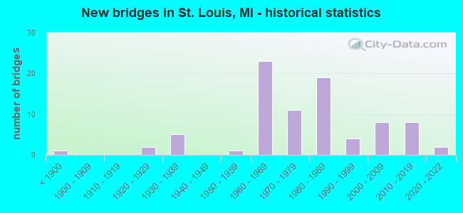
- New bridges - historical statistics
- 1Before 1900
- 21920-1929
- 51930-1939
- 11950-1959
- 231960-1969
- 111970-1979
- 191980-1989
- 41990-1999
- 82000-2009
- 82010-2019
- 22020-2022
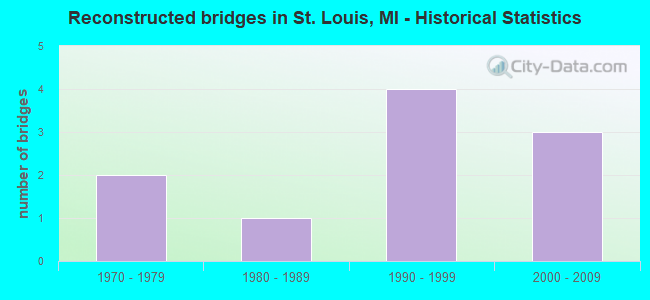
- Reconstructed bridges - Historical Statistics
- 21970-1979
- 11980-1989
- 41990-1999
- 32000-2009
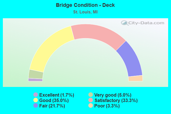
- Bridge Condition - Deck
- 1.7%Excellent
- 5.0%Very good
- 35.0%Good
- 33.3%Satisfactory
- 21.7%Fair
- 3.3%Poor

- Bridge Condition - Superstructure
- 3.3%Excellent
- 8.3%Very good
- 18.3%Good
- 28.3%Satisfactory
- 33.3%Fair
- 8.3%Poor
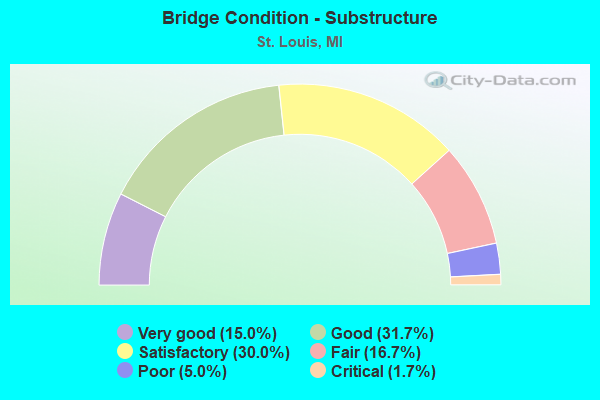
- Bridge Condition - Substructure
- 15.0%Very good
- 31.7%Good
- 30.0%Satisfactory
- 16.7%Fair
- 5.0%Poor
- 1.7%Critical
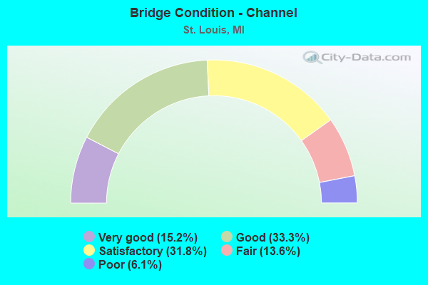
- Bridge Condition - Channel
- 15.2%Very good
- 33.3%Good
- 31.8%Satisfactory
- 13.6%Fair
- 6.1%Poor
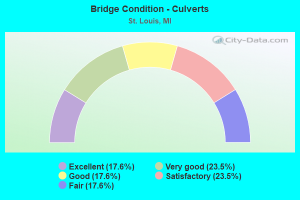
- Bridge Condition - Culverts
- 17.6%Excellent
- 23.5%Very good
- 17.6%Good
- 23.5%Satisfactory
- 17.6%Fair
Find on map >> Show street view
Structure Number: 3098, Location: 2.0 MI S OF ST LOUIS (Lat: 43.378811, Lng: -84.602725), Route carried "under" structure: Business US 127, Year Built: 1961, Structure Length: 0. m, Average Daily Traffic: 6,579 (year 2007), Truck Traffic: 7%, Features Intersected: US-127 BR
Minimum Vertical Clearance: 4.90m (16.08ft), Kilometerpoint: 18.869, Lanes on structure: 3, Lanes under structure: 3, Material/Design: Steel, Design/Construction: Stringer/Multi-beam, Length of Maximum Span: 19.1m (62.7ft)
Find on map >> Show street view
Structure Number: 3099, Location: 2.0 MI S OF ST LOUIS (Lat: 43.378817, Lng: -84.603167), Route carried "under" structure: Business US 127, Year Built: 1961, Structure Length: 0. m, Average Daily Traffic: 6,579 (year 2007), Truck Traffic: 7%, Features Intersected: US-127 BR
Minimum Vertical Clearance: 4.47m (14.67ft), Kilometerpoint: 18.906, Lanes on structure: 2, Lanes under structure: 3, Material/Design: Steel, Design/Construction: Stringer/Multi-beam, Length of Maximum Span: 19.3m (63.3ft)
Find on map >> Show street view
Structure Number: 31, Location: 1.5 MI S OF ST LOUIS (Lat: 43.382108, Lng: -84.607106), Route carried "under" structure: Business US 127, Year Built: 1961, Structure Length: 0. m, Average Daily Traffic: 4,158 (year 2007), Truck Traffic: 5%, Features Intersected: US-127 BR
Minimum Vertical Clearance: 4.52m (14.83ft), Kilometerpoint: 11.657, Lanes on structure: 2, Lanes under structure: 3, Material/Design: Steel, Design/Construction: Stringer/Multi-beam, Length of Maximum Span: 16.2m (53.1ft)
Find on map >> Show street view
Structure Number: 3101, Location: 1.5 MI S OF ST LOUIS (Lat: 43.381789, Lng: -84.607111), Route carried "under" structure: Business US 127, Year Built: 1961, Structure Length: 0. m, Average Daily Traffic: 4,158 (year 2007), Truck Traffic: 5%, Features Intersected: US-127 BR
Minimum Vertical Clearance: 4.72m (15.49ft), Kilometerpoint: 11.621, Lanes on structure: 3, Lanes under structure: 3, Material/Design: Steel, Design/Construction: Stringer/Multi-beam, Length of Maximum Span: 16.2m (53.1ft)
Find on map >> Show street view
Structure Number: 3102, Location: NE LTS OF ALMA (Lat: 43.393239, Lng: -84.626250), Route carried "under" structure: City street 2033, Year Built: 1961, Structure Length: 0. m, Average Daily Traffic: 5,031 (year 1989), Features Intersected: MICHIGAN AVE, Facility Carried by Structure: US-127 NB
Minimum Vertical Clearance: 5.13m (16.83ft), Kilometerpoint: 2.641, Lanes on structure: 2, Lanes under structure: 2, Material/Design: Steel, Design/Construction: Stringer/Multi-beam, Length of Maximum Span: 19.5m (64.0ft)
Find on map >> Show street view
Structure Number: 3103, Location: NE LTS OF ALMA (Lat: 43.393078, Lng: -84.626528), Route carried "under" structure: City street 2033, Year Built: 1961, Structure Length: 0. m, Average Daily Traffic: 5,031 (year 1989), Features Intersected: MICHIGAN AVE, Facility Carried by Structure: US-127 SB
Minimum Vertical Clearance: 4.44m (14.57ft), Kilometerpoint: 2.610, Lanes on structure: 2, Lanes under structure: 2, Material/Design: Steel, Design/Construction: Stringer/Multi-beam, Length of Maximum Span: 19.5m (64.0ft)
Find on map >> Show street view
Structure Number: 3114, Location: 2.0 MI S OF ISABELLA COL (Lat: 43.436903, Lng: -84.677078), Route carried "under" structure: US 127, Year Built: 1964, Structure Length: 0. m, Average Daily Traffic: 20,238 (year 2007), Truck Traffic: 9%, Features Intersected: US-127, Facility Carried by Structure: JEFFERSON RD
Minimum Vertical Clearance: 4.44m (14.57ft), Kilometerpoint: 39.630, Lanes on structure: 2, Lanes under structure: 4, Material/Design: Prestressed concrete, Design/Construction: Stringer/Multi-beam, Length of Maximum Span: 21.9m (71.9ft)