Bridge Statistics for Tukwila, Washington (WA)
Condition, Traffic, Stress, Structural Evaluation, Project Costs
- National Bridge Inventory (NBI) Statistics
- 107Number of bridges
- 1,811ft / 552mTotal length
- $510,613,000Total costs
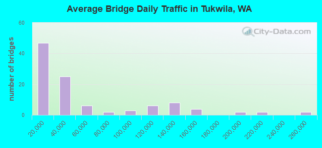
- 5,471,184Total average daily traffic
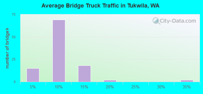
- 407,932Total average daily truck traffic
- National Bridge Inventory (NBI) Registered Bridges for Tukwila
- No street view available for this location
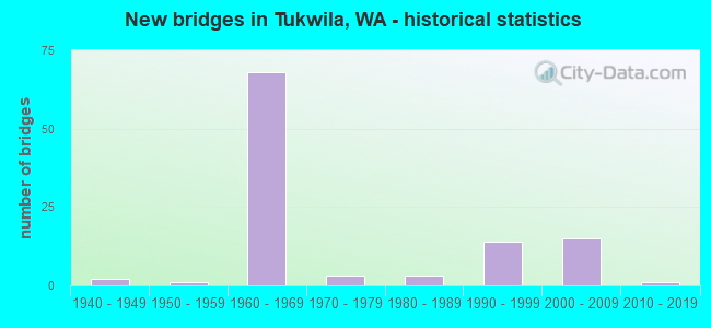
- New bridges - historical statistics
- 21940-1949
- 11950-1959
- 681960-1969
- 31970-1979
- 31980-1989
- 141990-1999
- 152000-2009
- 12010-2019
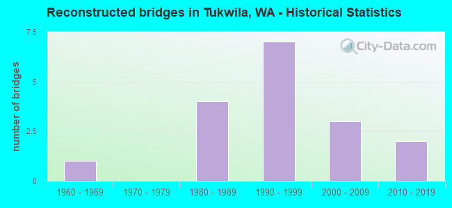
- Reconstructed bridges - Historical Statistics
- 11960-1969
- 01970-1979
- 41980-1989
- 71990-1999
- 32000-2009
- 22010-2019
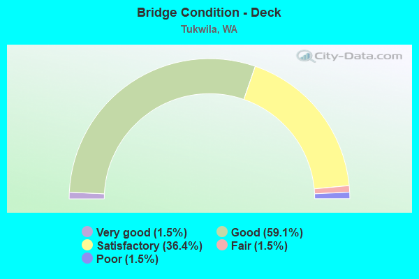
- Bridge Condition - Deck
- 1.5%Very good
- 59.1%Good
- 36.4%Satisfactory
- 1.5%Fair
- 1.5%Poor
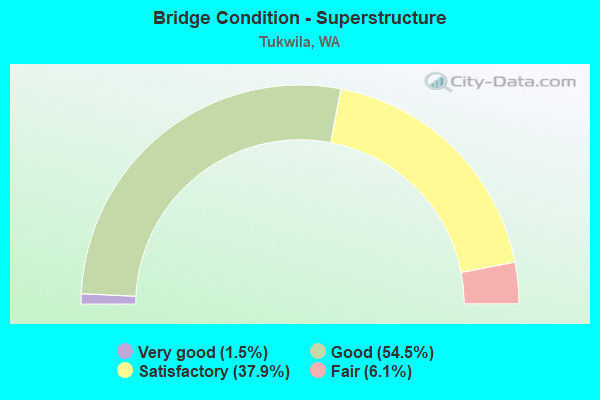
- Bridge Condition - Superstructure
- 1.5%Very good
- 54.5%Good
- 37.9%Satisfactory
- 6.1%Fair
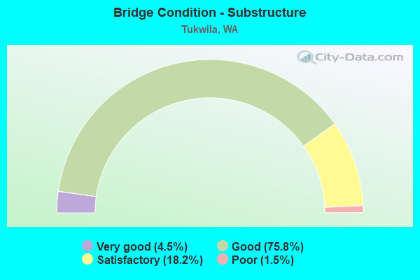
- Bridge Condition - Substructure
- 4.5%Very good
- 75.8%Good
- 18.2%Satisfactory
- 1.5%Poor
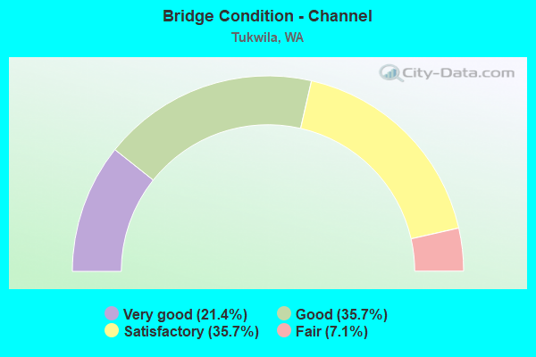
- Bridge Condition - Channel
- 21.4%Very good
- 35.7%Good
- 35.7%Satisfactory
- 7.1%Fair
Find on map >> Show street view
Structure Number: 7967C, Location: JCT SR 99 (Lat: 47.497889, Lng: -122.295889), Route carried "on" structure: Ramp State highway 99, Year Built: 1966, Status: Posted for load, Structure Length: 5.97m (19.59ft), Average Daily Traffic: 1,262 (year 2019), Truck Traffic: 5%, Average Future Daily Traffic: 1,781 (year 2039), Design Load: HS 20+Mod, Features Intersected: S 116TH WAY, Facility Carried by Structure: S-S RAMP
Minimum Vertical Clearance: 30+ m (98+ ft), Kilometerpoint: 0.435, Lanes on structure: 1, Lanes under structure: 4, Owner: State Highway Agency, Approaching Roadway Width: 7.9m (25.9ft), Skew: 2 degrees, Material/Design: Prestressed concrete, Design/Construction: Stringer/Multi-beam, Number Of Spans In Main Unit: 3, Length of Maximum Span: 25.9m (85.0ft), Curb or Sidewalk Widths: Left: 0.2m (0.7ft), Right: 0.2m (0.7ft), Curb-To-Curb Width: 7.0m (23.0ft), Out-to-Out Width: 8.0m (26.2ft)
Condition: Deck: Good, Superstructure: Satisfactory, Substructure: Good, Operating Rating: 15.6 metric tons, Method Used To Determine Operating Rating: Load and Resistance Factor Rating (LRFR) rating reported by rating factor(RF) method using HL-93 loadings, Inventory Rating: 12.0 metric tons, Method Used To Determine Inventory Rating: Load and Resistance Factor Rating (LRFR) rating reported by rating factor(RF) method using HL-93 loadings, Structural Evaluation: High priority of corrective action, Deck Geometry: Equal to present minimum criteria, Underclear: High priority of corrective action, Approach Roadway Alignment: Equal to present desirable criteria, Bridge Posting: Required (Relationship of Operating Rating to Maximum Legal Load: 20.0 - 29.9% below), Length Of Structure Improvement: 5.97m (19.59ft), Designated Inspection Frequency: Every 24 months, Inspection Date: May 2020, Bridge Improvement Cost: $1,098,000, Roadway Improvement Cost: $220,000, Total Project Cost: $2,195,000 ( Estimate for 2014), Deck Structure Type: Concrete Cast-file-Place, Wearing Surface/Protective System: Wearing Surface: Bituminous, Membrane: Preformed Fabric
Find on map >> Show street view
Structure Number: 7967D, Location: 1.8 N JCT I-5 (Lat: 47.497778, Lng: -122.294972), Route carried "on" structure: State highway 99, Year Built: 1966, Status: Posted for load, Structure Length: 7.19m (23.59ft), Average Daily Traffic: 18,669 (year 2019), Truck Traffic: 13%, Average Future Daily Traffic: 26,360 (year 2039), Design Load: HS 20+Mod, Features Intersected: TUKWILA INT'L BLVD
Minimum Vertical Clearance: 30+ m (98+ ft), Kilometerpoint: 36.967, Lanes on structure: 2, Lanes under structure: 6, Base Highway Network: Yes, Owner: State Highway Agency, Approaching Roadway Width: 12.2m (40.0ft), Skew: 3 degrees, Material/Design: Prestressed concrete, Design/Construction: Stringer/Multi-beam, Number Of Spans In Main Unit: 3, Length of Maximum Span: 37.8m (124.0ft), Curb or Sidewalk Widths: Left: 0.2m (0.7ft), Right: 0.2m (0.7ft), Curb-To-Curb Width: 11.6m (38.1ft), Out-to-Out Width: 12.7m (41.7ft)
Condition: Deck: Good, Superstructure: Satisfactory, Substructure: Good, Operating Rating: 19.8 metric tons, Method Used To Determine Operating Rating: Load and Resistance Factor Rating (LRFR) rating reported by rating factor(RF) method using HL-93 loadings, Inventory Rating: 15.2 metric tons, Method Used To Determine Inventory Rating: Load and Resistance Factor Rating (LRFR) rating reported by rating factor(RF) method using HL-93 loadings, Structural Evaluation: High priority of corrective action, Deck Geometry: Equal to present minimum criteria, Underclear: Meets minimum limits, Approach Roadway Alignment: Equal to present desirable criteria, Bridge Posting: Required (Relationship of Operating Rating to Maximum Legal Load: 0.1 - 9.9% below), Length Of Structure Improvement: 7.19m (23.59ft), Designated Inspection Frequency: Every 24 months, Inspection Date: May 2020, Bridge Improvement Cost: $1,982,000, Roadway Improvement Cost: $396,000, Total Project Cost: $3,965,000 ( Estimate for 2014), Deck Structure Type: Concrete Cast-file-Place, Wearing Surface/Protective System: Wearing Surface: Bituminous, Membrane: Preformed Fabric
Find on map >> Show street view
Structure Number: 8103A, Location: 0.6 N JCT I-5 (Lat: 47.488917, Lng: -122.280111), Route carried "on" structure: State highway 599, Year Built: 1968, Status: Open, Structure Length: 7.13m (23.39ft), Average Daily Traffic: 24,924 (year 2019), Truck Traffic: 12%, Average Future Daily Traffic: 35,192 (year 2039), Design Load: HS 20+Mod, Features Intersected: 42ND AVE S / MACADAM RD
Minimum Vertical Clearance: 30+ m (98+ ft), Kilometerpoint: 1.046, Lanes on structure: 2, Lanes under structure: 2, Base Highway Network: Yes, Owner: State Highway Agency, Approaching Roadway Width: 11.6m (38.1ft), Skew: 4 degrees, Material/Design: Prestressed concrete, Design/Construction: Stringer/Multi-beam, Number Of Spans In Main Unit: 3, Length of Maximum Span: 30.5m (100.1ft), Curb or Sidewalk Widths: Left: 0.2m (0.7ft), Right: 0.2m (0.7ft), Curb-To-Curb Width: 11.1m (36.4ft), Out-to-Out Width: 12.2m (40.0ft)
Condition: Deck: Good, Superstructure: Satisfactory, Substructure: Good, Operating Rating: 60.8 metric tons, Method Used To Determine Operating Rating: Load Factor (LF), Inventory Rating: 35.4 metric tons, Method Used To Determine Inventory Rating: Load Factor (LF), Structural Evaluation: Equal to present minimum criteria, Deck Geometry: Somewhat better than minimum adequacy, Underclear: Superior to present desirable criteria, Approach Roadway Alignment: Equal to present desirable criteria, Length Of Structure Improvement: 7.13m (23.39ft), Designated Inspection Frequency: Every 24 months, Inspection Date: March 2020, Bridge Improvement Cost: $1,872,000, Roadway Improvement Cost: $374,000, Total Project Cost: $3,744,000 ( Estimate for 2014), Deck Structure Type: Concrete Cast-file-Place, Wearing Surface/Protective System: Wearing Surface: Monolithic Concrete
Find on map >> Show street view
Structure Number: 8103B, Location: 0.6 N JCT I-5 (Lat: 47.488667, Lng: -122.280167), Route carried "on" structure: State highway 599, Year Built: 1968, Status: Open, Structure Length: 6.71m (22.01ft), Average Daily Traffic: 24,924 (year 2019), Truck Traffic: 12%, Average Future Daily Traffic: 35,192 (year 2039), Design Load: HS 20+Mod, Features Intersected: 42ND AVE S
Minimum Vertical Clearance: 30+ m (98+ ft), Kilometerpoint: 1.046, Lanes on structure: 2, Lanes under structure: 2, Base Highway Network: Yes, Owner: State Highway Agency, Approaching Roadway Width: 11.0m (36.1ft), Skew: 4 degrees, Material/Design: Prestressed concrete, Design/Construction: Stringer/Multi-beam, Number Of Spans In Main Unit: 3, Length of Maximum Span: 30.5m (100.1ft), Curb or Sidewalk Widths: Left: 0.2m (0.7ft), Right: 0.2m (0.7ft), Curb-To-Curb Width: 11.1m (36.4ft), Out-to-Out Width: 12.2m (40.0ft)
Condition: Deck: Good, Superstructure: Satisfactory, Substructure: Good, Operating Rating: 58.0 metric tons, Method Used To Determine Operating Rating: Load Factor (LF), Inventory Rating: 34.5 metric tons, Method Used To Determine Inventory Rating: Load Factor (LF), Structural Evaluation: Equal to present minimum criteria, Deck Geometry: Somewhat better than minimum adequacy, Underclear: Better than present minimum criteria, Approach Roadway Alignment: Equal to present desirable criteria, Length Of Structure Improvement: 6.71m (22.01ft), Designated Inspection Frequency: Every 48 months, Inspection Date: May 2018, Bridge Improvement Cost: $1,672,000, Roadway Improvement Cost: $334,000, Total Project Cost: $3,344,000 ( Estimate for 2014), Deck Structure Type: Concrete Cast-file-Place, Wearing Surface/Protective System: Wearing Surface: Latex Concrete
Find on map >> Show street view
Structure Number: 8103C, Location: 1.4 N JCT I-5 (Lat: 47.497164, Lng: -122.287083), Route carried "on" structure: City street , Year Built: 1967, Status: Open, Structure Length: 7.32m (24.02ft), Average Daily Traffic: 5,600 (year 2002), Truck Traffic: 7%, Average Future Daily Traffic: 9,789 (year 2036), Design Load: HS 20+Mod, Features Intersected: SR 599, Facility Carried by Structure: E MARGINAL WAY
Minimum Vertical Clearance: 30+ m (98+ ft), Kilometerpoint: 0.064, Lanes on structure: 2, Lanes under structure: 4, Owner: State Highway Agency, Approaching Roadway Width: 12.8m (42.0ft), Skew: 2 degrees, Material/Design: Prestressed concrete continuous, Design/Construction: Stringer/Multi-beam, Number Of Spans In Main Unit: 4, Length of Maximum Span: 22.3m (73.2ft), Curb or Sidewalk Widths: Left: 0.9m (3.0ft), Right: 0.9m (3.0ft), Curb-To-Curb Width: 9.1m (29.9ft), Out-to-Out Width: 11.6m (38.1ft)
Condition: Deck: Good, Superstructure: Good, Substructure: Good, Operating Rating: 45.4 metric tons, Method Used To Determine Operating Rating: Load Factor (LF), Inventory Rating: 27.2 metric tons, Method Used To Determine Inventory Rating: Load Factor (LF), Structural Evaluation: Equal to present minimum criteria, Deck Geometry: Meets minimum limits, Underclear: Somewhat better than minimum adequacy, Approach Roadway Alignment: Equal to present desirable criteria, Length Of Structure Improvement: 7.32m (24.02ft), Designated Inspection Frequency: Every 24 months, Inspection Date: November 2020, Bridge Improvement Cost: $2,112,000, Roadway Improvement Cost: $422,000, Total Project Cost: $4,224,000 ( Estimate for 2014), Deck Structure Type: Concrete Cast-file-Place, Wearing Surface/Protective System: Wearing Surface: Bituminous, Membrane: Preformed Fabric
Find on map >> Show street view
Structure Number: 13354A, Location: 0.8 N JCT I-5 (Lat: 47.462889, Lng: -122.249667), Route carried "on" structure: City street , Year Built: 1990, Status: Open, Structure Length: 6.25m (20.51ft), Average Daily Traffic: 12,000 (year 2010), Truck Traffic: 3%, Average Future Daily Traffic: 19,368 (year 2032), Design Load: HS 20+Mod, Features Intersected: I-405, Facility Carried by Structure: 66TH AVE S
Minimum Vertical Clearance: 30+ m (98+ ft), Kilometerpoint: 5.617, Lanes on structure: 5, Lanes under structure: 10, Owner: State Highway Agency, Approaching Roadway Width: 18.9m (62.0ft), Material/Design: Prestressed concrete continuous, Design/Construction: Stringer/Multi-beam, Number Of Spans In Main Unit: 2, Length of Maximum Span: 31.7m (104.0ft), Curb or Sidewalk Widths: Left: 2.0m (6.6ft), Right: 0.0m, Curb-To-Curb Width: 18.9m (62.0ft), Out-to-Out Width: 21.6m (70.9ft)
Condition: Deck: Good, Superstructure: Good, Substructure: Good, Operating Rating: 64.4 metric tons, Method Used To Determine Operating Rating: Load Factor (LF), Inventory Rating: 38.1 metric tons, Method Used To Determine Inventory Rating: Load Factor (LF), Structural Evaluation: Better than present minimum criteria, Deck Geometry: Meets minimum limits, Underclear: High priority of corrective action, Approach Roadway Alignment: Equal to present desirable criteria, Length Of Structure Improvement: 6.25m (20.51ft), Designated Inspection Frequency: Every 48 months, Inspection Date: April 2018, Bridge Improvement Cost: $2,624,000, Roadway Improvement Cost: $525,000, Total Project Cost: $5,248,000 ( Estimate for 2014), Deck Structure Type: Concrete Cast-file-Place, Wearing Surface/Protective System: Wearing Surface: Monolithic Concrete, Deck Protection: Epoxy Coated Reinforcing
Find on map >> Show street view
Structure Number: 14269A, Location: 0.9 N JCT I-5 (Lat: 47.463861, Lng: -122.247556), Route carried "on" structure: Ramp Interstate 405, Year Built: 1994, Status: Open, Structure Length: 5.64m (18.50ft), Average Daily Traffic: 7,257 (year 2019), Truck Traffic: 5%, Average Future Daily Traffic: 10,246 (year 2039), Design Load: HS 25 or greater, Features Intersected: SOUTHCENTER BLVD
Minimum Vertical Clearance: 30+ m (98+ ft), Kilometerpoint: 0.209, Lanes on structure: 1, Lanes under structure: 5, Owner: State Highway Agency, Approaching Roadway Width: 10.4m (34.1ft), Skew: 2 degrees, Material/Design: Concrete continuous, Design/Construction: Box Beam or Girders - Multiple, Number Of Spans In Main Unit: 3, Length of Maximum Span: 25.6m (84.0ft), Curb-To-Curb Width: 10.5m (34.4ft), Out-to-Out Width: 11.1m (36.4ft)
Condition: Deck: Good, Superstructure: Good, Substructure: Very good, Operating Rating: 89.8 metric tons, Method Used To Determine Operating Rating: Load Factor (LF), Inventory Rating: 75.3 metric tons, Method Used To Determine Inventory Rating: Load Factor (LF), Structural Evaluation: Better than present minimum criteria, Deck Geometry: Superior to present desirable criteria, Underclear: Equal to present minimum criteria, Approach Roadway Alignment: Equal to present minimum criteria, Length Of Structure Improvement: 5.64m (18.50ft), Designated Inspection Frequency: Every 48 months, Inspection Date: June 2021, Bridge Improvement Cost: $1,332,000, Roadway Improvement Cost: $266,000, Total Project Cost: $2,664,000 ( Estimate for 2014), Deck Structure Type: Concrete Cast-file-Place, Wearing Surface/Protective System: Wearing Surface: Monolithic Concrete, Deck Protection: Epoxy Coated Reinforcing
Find on map >> Show street view
Structure Number: 14269B, Location: 0.9 N JCT I-5 (Lat: 47.463972, Lng: -122.247139), Route carried "on" structure: Ramp Interstate 405, Year Built: 1994, Status: Open, Structure Length: 6.00m (19.69ft), Average Daily Traffic: 9,236 (year 2019), Truck Traffic: 5%, Average Future Daily Traffic: 13,041 (year 2039), Design Load: HS 25 or greater, Features Intersected: SOUTHCENTER BLVD
Minimum Vertical Clearance: 30+ m (98+ ft), Kilometerpoint: 0.225, Lanes on structure: 1, Lanes under structure: 5, Owner: State Highway Agency, Approaching Roadway Width: 7.3m (24.0ft), Skew: 2 degrees, Material/Design: Concrete continuous, Design/Construction: Box Beam or Girders - Multiple, Number Of Spans In Main Unit: 3, Length of Maximum Span: 27.7m (90.9ft), Curb-To-Curb Width: 7.5m (24.6ft), Out-to-Out Width: 8.4m (27.6ft)
Condition: Deck: Good, Superstructure: Good, Substructure: Good, Operating Rating: 80.7 metric tons, Method Used To Determine Operating Rating: Load Factor (LF), Inventory Rating: 48.1 metric tons, Method Used To Determine Inventory Rating: Load Factor (LF), Structural Evaluation: Better than present minimum criteria, Deck Geometry: Better than present minimum criteria, Underclear: Meets minimum limits, Approach Roadway Alignment: Equal to present desirable criteria, Length Of Structure Improvement: 6.00m (19.69ft), Designated Inspection Frequency: Every 48 months, Inspection Date: June 2021, Bridge Improvement Cost: $1,024,000, Roadway Improvement Cost: $205,000, Total Project Cost: $2,049,000 ( Estimate for 2014), Deck Structure Type: Concrete Cast-file-Place, Wearing Surface/Protective System: Wearing Surface: Monolithic Concrete, Deck Protection: Epoxy Coated Reinforcing
Find on map >> Show street view
Structure Number: 14269C, Location: 0.1 N I-405 (Lat: 47.464889, Lng: -122.248222), Route carried "on" structure: Ramp Interstate 405, Year Built: 1994, Status: Open, Structure Length: 7.07m (23.20ft), Average Daily Traffic: 7,257 (year 2019), Truck Traffic: 5%, Average Future Daily Traffic: 10,246 (year 2039), Design Load: HS 25 or greater, Features Intersected: GREEN RIVER, Facility Carried by Structure: RAMP ACCESS ROAD
Minimum Vertical Clearance: 30+ m (98+ ft), Kilometerpoint: 0.097, Lanes on structure: 4, Owner: State Highway Agency, Approaching Roadway Width: 23.2m (76.1ft), Skew: 33 degrees, Material/Design: Prestressed concrete continuous, Design/Construction: Stringer/Multi-beam, Number Of Spans In Main Unit: 3, Length of Maximum Span: 32.9m (107.9ft), Curb-To-Curb Width: 23.8m (78.1ft), Out-to-Out Width: 24.3m (79.7ft)
Condition: Deck: Good, Superstructure: Good, Substructure: Good, Channel: Very good, Operating Rating: 66.2 metric tons, Method Used To Determine Operating Rating: Load Factor (LF), Inventory Rating: 39.9 metric tons, Method Used To Determine Inventory Rating: Load Factor (LF), Structural Evaluation: Better than present minimum criteria, Deck Geometry: Superior to present desirable criteria, Waterway Adequacy: Equal to present desirable criteria, Approach Roadway Alignment: Equal to present minimum criteria, Length Of Structure Improvement: 7.07m (23.20ft), Designated Inspection Frequency: Every 48 months, Inspection Date: July 2018, Bridge Improvement Cost: $3,619,000, Roadway Improvement Cost: $724,000, Total Project Cost: $7,238,000 ( Estimate for 2014), Deck Structure Type: Concrete Cast-file-Place, Wearing Surface/Protective System: Wearing Surface: Monolithic Concrete, Deck Protection: Epoxy Coated Reinforcing
Find on map >> Show street view
Structure Number: 14269D, Location: 0.12 MI E INTRURBAN AVE S (Lat: 47.463636, Lng: -122.248781), Route carried "on" structure: City street 1147, Year Built: 1994, Status: Open, Structure Length: 7.47m (24.51ft), Average Daily Traffic: 10,616 (year 2018), Truck Traffic: 4%, Average Future Daily Traffic: 29,000 (year 2038), Design Load: HS 20+Mod, Features Intersected: GREEN RIVER, Facility Carried by Structure: SOUTHCENTER BLVD
Minimum Vertical Clearance: 30+ m (98+ ft), Kilometerpoint: 0.001, Lanes on structure: 5, Owner: City or Municipal Highway Agency, Approaching Roadway Width: 18.9m (62.0ft), Skew: 2 degrees, Material/Design: Prestressed concrete continuous, Design/Construction: Stringer/Multi-beam, Number Of Spans In Main Unit: 3, Length of Maximum Span: 35.1m (115.2ft), Curb or Sidewalk Widths: Left: 2.4m (7.9ft), Right: 0.0m, Curb-To-Curb Width: 18.9m (62.0ft), Out-to-Out Width: 21.9m (71.9ft)
Condition: Deck: Satisfactory, Superstructure: Satisfactory, Substructure: Satisfactory, Channel: Good, Operating Rating: 71.9 metric tons, Method Used To Determine Operating Rating: Load Factor (LF) rating reported by rating factor (RF) method using MS18 loading, Inventory Rating: 43.1 metric tons, Method Used To Determine Inventory Rating: Load Factor (LF) rating reported by rating factor (RF) method using MS18 loading, Structural Evaluation: Equal to present minimum criteria, Deck Geometry: Meets minimum limits, Waterway Adequacy: Equal to present desirable criteria, Approach Roadway Alignment: Equal to present desirable criteria, Length Of Structure Improvement: 7.47m (24.51ft), Designated Inspection Frequency: Every 24 months, Inspection Date: August 2020, Bridge Improvement Cost: $3,136,000, Roadway Improvement Cost: $627,000, Total Project Cost: $6,272,000 ( Estimate for 2014), Deck Structure Type: Concrete Cast-file-Place, Wearing Surface/Protective System: Wearing Surface: Monolithic Concrete, Deck Protection: Epoxy Coated Reinforcing
Find on map >> Show street view
Structure Number: 14543A, Location: 0.1 N JCT SR 599 (Lat: 47.483417, Lng: -122.270722), Route carried "on" structure: Interstate 5, Year Built: 1996, Status: Open, Structure Length: 4.82m (15.81ft), Average Daily Traffic: 10,699 (year 2019), Truck Traffic: 7%, Average Future Daily Traffic: 15,106 (year 2039), Design Load: HS 25 or greater, Features Intersected: INTERURBAN AVE
Minimum Vertical Clearance: 30+ m (98+ ft), Kilometerpoint: 0.016, Lanes on structure: 1, Lanes under structure: 4, Base Highway Network: Yes, Owner: State Highway Agency, Approaching Roadway Width: 7.9m (25.9ft), Skew: 1 degrees, Material/Design: Prestressed concrete continuous, Design/Construction: Stringer/Multi-beam, Number Of Spans In Main Unit: 3, Length of Maximum Span: 19.8m (65.0ft), Curb-To-Curb Width: 7.9m (25.9ft), Out-to-Out Width: 8.5m (27.9ft)
Condition: Deck: Good, Superstructure: Very good, Substructure: Very good, Operating Rating: 51.5 metric tons, Method Used To Determine Operating Rating: Load and Resistance Factor Rating (LRFR) rating reported by rating factor(RF) method using HL-93 loadings, Inventory Rating: 39.5 metric tons, Method Used To Determine Inventory Rating: Load and Resistance Factor Rating (LRFR) rating reported by rating factor(RF) method using HL-93 loadings, Structural Evaluation: Equal to present desirable criteria, Deck Geometry: High priority of replacement, Underclear: High priority of corrective action, Approach Roadway Alignment: Equal to present desirable criteria, Length Of Structure Improvement: 4.82m (15.81ft), Designated Inspection Frequency: Every 48 months, Inspection Date: September 2018, Bridge Improvement Cost: $885,000, Roadway Improvement Cost: $177,000, Total Project Cost: $1,770,000 ( Estimate for 2014), Deck Structure Type: Concrete Cast-file-Place, Wearing Surface/Protective System: Wearing Surface: Monolithic Concrete, Deck Protection: Epoxy Coated Reinforcing
Find on map >> Show street view
Structure Number: 14621A, Location: JCT I-405 (Lat: 47.457444, Lng: -122.263917), Route carried "on" structure: Interstate 5, Year Built: 1996, Status: Open, Structure Length: 5.21m (17.09ft), Average Daily Traffic: 7,078 (year 2019), Truck Traffic: 10%, Average Future Daily Traffic: 9,994 (year 2039), Design Load: HS 25 or greater, Features Intersected: KLICKITAT DR
Minimum Vertical Clearance: 30+ m (98+ ft), Kilometerpoint: 0.756, Lanes on structure: 1, Lanes under structure: 4, Base Highway Network: Yes, Owner: State Highway Agency, Approaching Roadway Width: 7.9m (25.9ft), Skew: 1 degrees, Material/Design: Prestressed concrete continuous, Design/Construction: Stringer/Multi-beam, Number Of Spans In Main Unit: 3, Length of Maximum Span: 21.0m (68.9ft), Curb-To-Curb Width: 7.9m (25.9ft), Out-to-Out Width: 8.8m (28.9ft)
Condition: Deck: Good, Superstructure: Good, Substructure: Good, Operating Rating: 86.2 metric tons, Method Used To Determine Operating Rating: Load Factor (LF), Inventory Rating: 51.7 metric tons, Method Used To Determine Inventory Rating: Load Factor (LF), Structural Evaluation: Better than present minimum criteria, Deck Geometry: High priority of replacement, Underclear: High priority of corrective action, Approach Roadway Alignment: Equal to present desirable criteria, Length Of Structure Improvement: 5.21m (17.09ft), Designated Inspection Frequency: Every 48 months, Inspection Date: May 2021, Bridge Improvement Cost: $958,000, Roadway Improvement Cost: $192,000, Total Project Cost: $1,915,000 ( Estimate for 2014), Deck Structure Type: Concrete Cast-file-Place, Wearing Surface/Protective System: Wearing Surface: Monolithic Concrete, Deck Protection: Epoxy Coated Reinforcing
Find on map >> Show street view
Structure Number: 14621B, Location: 5.2 N JCT SR 516 (Lat: 47.461083, Lng: -122.263917), Route carried "on" structure: Interstate 5, Year Built: 1996, Status: Open, Structure Length: 27.25m (89.40ft), Average Daily Traffic: 7,295 (year 2019), Truck Traffic: 12%, Average Future Daily Traffic: 10,300 (year 2039), Design Load: HS 25 or greater, Features Intersected: I-405 NB, RAMPS
Minimum Vertical Clearance: 5.18m (16.99ft), Kilometerpoint: 0.290, Lanes on structure: 2, Lanes under structure: 4, Base Highway Network: Yes, Owner: State Highway Agency, Approaching Roadway Width: 15.8m (51.8ft), Skew: 30 degrees, Material/Design: Prestressed concrete continuous, Design/Construction: Stringer/Multi-beam, Number Of Spans In Main Unit: 8, Length of Maximum Span: 39.0m (128.0ft), Curb-To-Curb Width: 15.8m (51.8ft), Out-to-Out Width: 17.4m (57.1ft)
Condition: Deck: Good, Superstructure: Good, Substructure: Good, Operating Rating: 86.2 metric tons, Method Used To Determine Operating Rating: Load Factor (LF), Inventory Rating: 51.7 metric tons, Method Used To Determine Inventory Rating: Load Factor (LF), Structural Evaluation: Better than present minimum criteria, Deck Geometry: Equal to present desirable criteria, Underclear: High priority of corrective action, Approach Roadway Alignment: Equal to present desirable criteria, Length Of Structure Improvement: 27.25m (89.40ft), Designated Inspection Frequency: Every 24 months, Inspection Date: July 2021, Bridge Improvement Cost: $9,655,000, Roadway Improvement Cost: $1,931,000, Total Project Cost: $19,310,000 ( Estimate for 2014), Deck Structure Type: Concrete Cast-file-Place, Wearing Surface/Protective System: Wearing Surface: Monolithic Concrete, Deck Protection: Epoxy Coated Reinforcing
Find on map >> Show street view
Structure Number: 14621C, Location: JCT I-405 & SR 518 (Lat: 47.464806, Lng: -122.266222), Route carried "on" structure: Interstate 5, Year Built: 1996, Status: Open, Structure Length: 3.96m (12.99ft), Average Daily Traffic: 7,295 (year 2019), Truck Traffic: 12%, Average Future Daily Traffic: 10,300 (year 2039), Design Load: HS 25 or greater, Features Intersected: SOUTHCENTER BLVD
Minimum Vertical Clearance: 30+ m (98+ ft), Kilometerpoint: 0.724, Lanes on structure: 2, Lanes under structure: 4, Base Highway Network: Yes, Owner: State Highway Agency, Approaching Roadway Width: 7.9m (25.9ft), Skew: 2 degrees, Material/Design: Prestressed concrete, Design/Construction: Stringer/Multi-beam, Number Of Spans In Main Unit: 1, Length of Maximum Span: 38.1m (125.0ft), Curb-To-Curb Width: 7.9m (25.9ft), Out-to-Out Width: 8.8m (28.9ft)
Condition: Deck: Good, Superstructure: Good, Substructure: Good, Operating Rating: 80.7 metric tons, Method Used To Determine Operating Rating: Load Factor (LF), Inventory Rating: 49.0 metric tons, Method Used To Determine Inventory Rating: Load Factor (LF), Structural Evaluation: Better than present minimum criteria, Deck Geometry: High priority of replacement, Underclear: Meets minimum limits, Approach Roadway Alignment: Equal to present desirable criteria, Length Of Structure Improvement: 3.96m (12.99ft), Designated Inspection Frequency: Every 24 months, Inspection Date: July 2021, Bridge Improvement Cost: $728,000, Roadway Improvement Cost: $146,000, Total Project Cost: $1,456,000 ( Estimate for 2014), Deck Structure Type: Concrete Cast-file-Place, Wearing Surface/Protective System: Wearing Surface: Monolithic Concrete, Deck Protection: Epoxy Coated Reinforcing
Find on map >> Show street view
Structure Number: 14812A, Location: 5.0 N JCT SR 516 (Lat: 47.458111, Lng: -122.264583), Route carried "on" structure: Ramp Interstate 5, Year Built: 1998, Status: Open, Structure Length: 4.27m (14.01ft), Average Daily Traffic: 20,073 (year 2019), Truck Traffic: 5%, Average Future Daily Traffic: 28,343 (year 2039), Design Load: HS 25 or greater, Features Intersected: KLICKITAT DRIVE
Minimum Vertical Clearance: 30+ m (98+ ft), Kilometerpoint: 0.612, Lanes on structure: 3, Lanes under structure: 3, Owner: State Highway Agency, Approaching Roadway Width: 14.6m (47.9ft), Skew: 2 degrees, Material/Design: Prestressed concrete, Design/Construction: Stringer/Multi-beam, Number Of Spans In Main Unit: 1, Length of Maximum Span: 40.8m (133.9ft), Curb-To-Curb Width: 14.6m (47.9ft), Out-to-Out Width: 15.2m (49.9ft)
Condition: Deck: Good, Superstructure: Good, Substructure: Good, Operating Rating: 89.8 metric tons, Method Used To Determine Operating Rating: Load Factor (LF), Inventory Rating: 57.1 metric tons, Method Used To Determine Inventory Rating: Load Factor (LF), Structural Evaluation: Better than present minimum criteria, Deck Geometry: Better than present minimum criteria, Underclear: High priority of corrective action, Approach Roadway Alignment: Equal to present desirable criteria, Length Of Structure Improvement: 4.27m (14.01ft), Designated Inspection Frequency: Every 24 months, Inspection Date: March 2020, Bridge Improvement Cost: $1,400,000, Roadway Improvement Cost: $280,000, Total Project Cost: $2,800,000 ( Estimate for 2014), Deck Structure Type: Concrete Cast-file-Place, Wearing Surface/Protective System: Wearing Surface: Monolithic Concrete, Deck Protection: Epoxy Coated Reinforcing
Find on map >> Show street view
Structure Number: 79968, Location: 0.5 MI E OF I-5 (Lat: 47.509531, Lng: -122.271472), Route carried "on" structure: City street 1203, Year Built: 1971, Year Reconstructed: 2018, Status: Open, Structure Length: 2.13m (6.99ft), Average Daily Traffic: 500 (year 2019), Truck Traffic: 10%, Average Future Daily Traffic: 550 (year 2039), Design Load: HS 20, Features Intersected: SO RYAN WY, Facility Carried by Structure: BEACON AVE S
Minimum Vertical Clearance: 30+ m (98+ ft), Kilometerpoint: 0.001, Lanes on structure: 2, Lanes under structure: 4, Owner: City or Municipal Highway Agency, Approaching Roadway Width: 12.2m (40.0ft), Material/Design: Steel, Design/Construction: Girder and Floorbeam System, Number Of Spans In Main Unit: 1, Length of Maximum Span: 20.7m (67.9ft), Curb or Sidewalk Widths: Left: 2.0m (6.6ft), Right: 2.0m (6.6ft), Curb-To-Curb Width: 8.3m (27.2ft), Out-to-Out Width: 12.9m (42.3ft)
Condition: Deck: Good, Superstructure: Satisfactory, Substructure: Satisfactory, Operating Rating: 29.8 metric tons, Method Used To Determine Operating Rating: Load and Resistance Factor Rating (LRFR) rating reported by rating factor(RF) method using HL-93 loadings, Inventory Rating: 23.0 metric tons, Method Used To Determine Inventory Rating: Load and Resistance Factor Rating (LRFR) rating reported by rating factor(RF) method using HL-93 loadings, Structural Evaluation: Equal to present minimum criteria, Deck Geometry: Somewhat better than minimum adequacy, Underclear: Meets minimum limits, Approach Roadway Alignment: Equal to present desirable criteria, Length Of Structure Improvement: 2.44m (8.01ft), Designated Inspection Frequency: Every 24 months, Critical Feature Inspection Frequency: Every 24 months, Inspection Date: April 2021, Critical Feature Inspection Date: April 2021, Bridge Improvement Cost: $1,216,000, Roadway Improvement Cost: $243,000, Total Project Cost: $2,432,000 ( Estimate for 2014), Deck Structure Type: Corrugated Steel, Wearing Surface/Protective System: Wearing Surface: Latex Concrete
Find on map >> Show street view
Structure Number: 80018, Location: 0.2 W E MARGINAL WY (Lat: 47.507483, Lng: -122.287006), Route carried "on" structure: City street 1380, Year Built: 1952, Status: Open, Structure Length: 5.55m (18.21ft), Average Daily Traffic: 40,000 (year 2019), Truck Traffic: 12%, Average Future Daily Traffic: 43,000 (year 2040), Design Load: H 20, Features Intersected: AIRPORT WAY BAR RAMP, Facility Carried by Structure: S BOEING ACCESS RD
Minimum Vertical Clearance: 30+ m (98+ ft), Kilometerpoint: 0.001, Lanes on structure: 5, Lanes under structure: 3, Base Highway Network: Yes, Owner: City or Municipal Highway Agency, Approaching Roadway Width: 20.1m (65.9ft), Skew: 21 degrees, Material/Design: Concrete continuous, Design/Construction: Tee Beam, Number Of Spans In Main Unit: 4, Length of Maximum Span: 15.8m (51.8ft), Curb or Sidewalk Widths: Left: 1.5m (4.9ft), Right: 1.5m (4.9ft), Curb-To-Curb Width: 16.2m (53.1ft), Out-to-Out Width: 20.0m (65.6ft)
Condition: Deck: Poor, Superstructure: Fair, Substructure: Satisfactory, Operating Rating: 44.1 metric tons, Method Used To Determine Operating Rating: Load Factor (LF) rating reported by rating factor (RF) method using MS18 loading, Inventory Rating: 26.2 metric tons, Method Used To Determine Inventory Rating: Load Factor (LF) rating reported by rating factor (RF) method using MS18 loading, Structural Evaluation: Somewhat better than minimum adequacy, Deck Geometry: High priority of replacement, Underclear: Better than present minimum criteria, Approach Roadway Alignment: Equal to present desirable criteria, Length Of Structure Improvement: 5.85m (19.19ft), Designated Inspection Frequency: Every 24 months, Inspection Date: April 2021, Bridge Improvement Cost: $5,683,000, Roadway Improvement Cost: $1,137,000, Total Project Cost: $11,366,000 ( Estimate for 2014), Deck Structure Type: Concrete Cast-file-Place, Wearing Surface/Protective System: Wearing Surface: Bituminous, Deck Protection: Bituminous
Find on map >> Show street view
Structure Number: 80025, Location: 0.3 MI W OF E MARGINAL WY (Lat: 47.507611, Lng: -122.284528), Route carried "on" structure: City street 1380, Year Built: 1945, Year Reconstructed: 2018, Status: Open, Structure Length: 10.27m (33.69ft), Average Daily Traffic: 40,000 (year 2021), Truck Traffic: 15%, Average Future Daily Traffic: 44,000 (year 2041), Design Load: H 15, Features Intersected: BNRR, Facility Carried by Structure: S BOEING ACCESS RD
Minimum Vertical Clearance: 30+ m (98+ ft), Kilometerpoint: 0.001, Lanes on structure: 6, Base Highway Network: Yes, Owner: City or Municipal Highway Agency, Approaching Roadway Width: 21.0m (68.9ft), Skew: 22 degrees, Material/Design: Steel continuous, Design/Construction: Stringer/Multi-beam, Number Of Spans In Main Unit: 3, Number Of Approach Spans: 2, Length of Maximum Span: 27.7m (90.9ft), Curb or Sidewalk Widths: Left: 0.0m, Right: 3.0m (9.8ft), Curb-To-Curb Width: 21.0m (68.9ft), Out-to-Out Width: 25.1m (82.3ft)
Condition: Deck: Satisfactory, Superstructure: Satisfactory, Substructure: Satisfactory, Operating Rating: 45.7 metric tons, Method Used To Determine Operating Rating: Load Factor (LF) rating reported by rating factor (RF) method using MS18 loading, Inventory Rating: 27.2 metric tons, Method Used To Determine Inventory Rating: Load Factor (LF) rating reported by rating factor (RF) method using MS18 loading, Structural Evaluation: Equal to present minimum criteria, Deck Geometry: High priority of replacement, Underclear: Meets minimum limits, Approach Roadway Alignment: Equal to present desirable criteria, Length Of Structure Improvement: 10.58m (34.71ft), Designated Inspection Frequency: Every 24 months, Inspection Date: April 2021, Bridge Improvement Cost: $11,937,000, Roadway Improvement Cost: $2,387,000, Total Project Cost: $23,874,000 ( Estimate for 2014), Deck Structure Type: Concrete Cast-file-Place, Wearing Surface/Protective System: Wearing Surface: Epoxy Overlay, Membrane: Other
Find on map >> Show street view
Structure Number: 81097, Location: 0.04 MI E OF SR-599 (Lat: 47.489750, Lng: -122.280278), Route carried "on" structure: City street 1037, Year Built: 1949, Status: Closed, Structure Length: 8.66m (28.41ft), Average Daily Traffic: 10,300 (year 2018), Truck Traffic: 30%, Average Future Daily Traffic: 12,000 (year 2038), Design Load: H 20, Features Intersected: DUWAMISH RIVER, Facility Carried by Structure: 42ND AVE SO
Minimum Vertical Clearance: 4.57m (14.99ft), Kilometerpoint: 0.001, Lanes on structure: 2, Owner: City or Municipal Highway Agency, Approaching Roadway Width: 11.0m (36.1ft), Skew: 3 degrees, Material/Design: Steel, Design/Construction: Truss - Thru, Number Of Spans In Main Unit: 1, Number Of Approach Spans: 2, Length of Maximum Span: 67.1m (220.1ft), Curb or Sidewalk Widths: Left: 0.0m, Right: 1.1m (3.6ft), Curb-To-Curb Width: 7.3m (24.0ft), Out-to-Out Width: 9.1m (29.9ft)
Condition: Deck: Fair, Superstructure: Fair, Substructure: Poor, Channel: Fair, Waterway Adequacy: Equal to present desirable criteria, Approach Roadway Alignment: Equal to present desirable criteria, Bridge Posting: Required (Relationship of Operating Rating to Maximum Legal Load: 30.0 - 39.9% below), Length Of Structure Improvement: 8.96m (29.40ft), Designated Inspection Frequency: Every 24 months, Critical Feature Inspection Frequency: Every 24 months, Inspection Date: April 2021, Critical Feature Inspection Date: April 2021, Bridge Improvement Cost: $4,469,000, Roadway Improvement Cost: $894,000, Total Project Cost: $8,938,000 ( Estimate for 2014), Deck Structure Type: Concrete Cast-file-Place, Wearing Surface/Protective System: Wearing Surface: Monolithic Concrete
Find on map >> Show street view
Structure Number: 81102, Location: 0.14 N JCT INTERURBAN AVE (Lat: 47.500219, Lng: -122.288128), Route carried "on" structure: City street 90705, Year Built: 1989, Status: Open, Structure Length: 8.29m (27.20ft), Average Daily Traffic: 13,000 (year 2019), Truck Traffic: 12%, Average Future Daily Traffic: 14,500 (year 2039), Design Load: H 20, Features Intersected: DUWAMISH RIVER, Facility Carried by Structure: EAST MARGINAL WAY
Minimum Vertical Clearance: 30+ m (98+ ft), Kilometerpoint: 0.001, Lanes on structure: 3, Base Highway Network: Yes, Owner: City or Municipal Highway Agency, Approaching Roadway Width: 14.6m (47.9ft), Material/Design: Prestressed concrete continuous, Design/Construction: Stringer/Multi-beam, Number Of Spans In Main Unit: 1, Number Of Approach Spans: 2, Length of Maximum Span: 53.6m (175.9ft), Curb or Sidewalk Widths: Left: 1.8m (5.9ft), Right: 1.8m (5.9ft), Curb-To-Curb Width: 14.6m (47.9ft), Out-to-Out Width: 18.7m (61.4ft)
Condition: Deck: Satisfactory, Superstructure: Good, Substructure: Good, Channel: Satisfactory, Operating Rating: 68.4 metric tons, Method Used To Determine Operating Rating: Load Factor (LF) rating reported by rating factor (RF) method using MS18 loading, Inventory Rating: 40.8 metric tons, Method Used To Determine Inventory Rating: Load Factor (LF) rating reported by rating factor (RF) method using MS18 loading, Structural Evaluation: Better than present minimum criteria, Deck Geometry: Somewhat better than minimum adequacy, Waterway Adequacy: Equal to present desirable criteria, Approach Roadway Alignment: Equal to present desirable criteria, Length Of Structure Improvement: 8.60m (28.22ft), Designated Inspection Frequency: Every 24 months, Inspection Date: April 2021, Bridge Improvement Cost: $5,640,000, Roadway Improvement Cost: $1,128,000, Total Project Cost: $11,280,000 ( Estimate for 2014), Deck Structure Type: Concrete Cast-file-Place, Wearing Surface/Protective System: Wearing Surface: Monolithic Concrete, Deck Protection: Epoxy Coated Reinforcing
Find on map >> Show street view
Structure Number: 81662, Location: 0.1E INTERURBAN AVE (Lat: 47.482500, Lng: -122.267444), Route carried "on" structure: City street 1427, Year Built: 1985, Status: Open, Structure Length: 7.44m (24.41ft), Average Daily Traffic: 2,850 (year 2019), Truck Traffic: 30%, Average Future Daily Traffic: 3,100 (year 2039), Design Load: HS 15, Features Intersected: DUWAMISH RIVER, Facility Carried by Structure: 56TH AVE SO
Minimum Vertical Clearance: 30+ m (98+ ft), Kilometerpoint: 0.001, Lanes on structure: 2, Owner: City or Municipal Highway Agency, Approaching Roadway Width: 8.5m (27.9ft), Material/Design: Concrete continuous, Design/Construction: Box Beam or Girders - Multiple, Number Of Spans In Main Unit: 2, Length of Maximum Span: 45.4m (149.0ft), Curb or Sidewalk Widths: Left: 1.5m (4.9ft), Right: 0.3m (1.0ft), Curb-To-Curb Width: 8.5m (27.9ft), Out-to-Out Width: 10.6m (34.8ft)
Condition: Deck: Good, Superstructure: Good, Substructure: Satisfactory, Channel: Satisfactory, Operating Rating: 48.0 metric tons, Method Used To Determine Operating Rating: Load Factor (LF) rating reported by rating factor (RF) method using MS18 loading, Inventory Rating: 28.8 metric tons, Method Used To Determine Inventory Rating: Load Factor (LF) rating reported by rating factor (RF) method using MS18 loading, Structural Evaluation: Equal to present minimum criteria, Deck Geometry: Meets minimum limits, Waterway Adequacy: Equal to present minimum criteria, Approach Roadway Alignment: Equal to present desirable criteria, Length Of Structure Improvement: 7.44m (24.41ft), Designated Inspection Frequency: Every 24 months, Inspection Date: April 2021, Bridge Improvement Cost: $1,464,000, Roadway Improvement Cost: $293,000, Total Project Cost: $2,928,000 ( Estimate for 2014), Deck Structure Type: Concrete Cast-file-Place, Wearing Surface/Protective System: Wearing Surface: Monolithic Concrete
Find on map >> Show street view
Structure Number: 83283, Location: 0.1 MI NW FORT DENT WAY (Lat: 47.468025, Lng: -122.248950), Route carried "on" structure: Spur County highway , Year Built: 1975, Status: Open, Structure Length: 6.19m (20.31ft), Average Daily Traffic: 1,115 (year 2018), Truck Traffic: 8%, Average Future Daily Traffic: 2,600 (year 2038), Design Load: HS 20, Features Intersected: GREEN RIVER, Facility Carried by Structure: STARFIRE WAY
Minimum Vertical Clearance: 30+ m (98+ ft), Kilometerpoint: 0.001, Lanes on structure: 2, Owner: City or Municipal Highway Agency, Approaching Roadway Width: 11.6m (38.1ft), Material/Design: Concrete continuous, Design/Construction: Box Beam or Girders - Multiple, Number Of Spans In Main Unit: 3, Length of Maximum Span: 30.5m (100.1ft), Curb or Sidewalk Widths: Left: 0.0m, Right: 1.5m (4.9ft), Curb-To-Curb Width: 7.9m (25.9ft), Out-to-Out Width: 10.4m (34.1ft)
Condition: Deck: Satisfactory, Superstructure: Satisfactory, Substructure: Satisfactory, Channel: Good, Operating Rating: 71.0 metric tons, Method Used To Determine Operating Rating: Load Factor (LF) rating reported by rating factor (RF) method using MS18 loading, Inventory Rating: 42.4 metric tons, Method Used To Determine Inventory Rating: Load Factor (LF) rating reported by rating factor (RF) method using MS18 loading, Structural Evaluation: Equal to present minimum criteria, Deck Geometry: Meets minimum limits, Waterway Adequacy: Equal to present desirable criteria, Approach Roadway Alignment: Equal to present minimum criteria, Length Of Structure Improvement: 6.49m (21.29ft), Designated Inspection Frequency: Every 24 months, Inspection Date: August 2020, Bridge Improvement Cost: $3,238,000, Roadway Improvement Cost: $648,000, Total Project Cost: $6,475,000 ( Estimate for 2014), Deck Structure Type: Concrete Cast-file-Place
Find on map >> Show street view
Structure Number: 85436, Location: 0.1 MI E OF INTERURBAN (Lat: 47.464686, Lng: -122.243864), Route carried "on" structure: City street 1288, Year Built: 1986, Status: Open, Structure Length: 36.73m (120.51ft), Average Daily Traffic: 26,000 (year 2021), Truck Traffic: 7%, Average Future Daily Traffic: 28,000 (year 2041), Design Load: HS 20+Mod, Features Intersected: UPRR & BNRR, Facility Carried by Structure: GRADY WAY
Minimum Vertical Clearance: 30+ m (98+ ft), Kilometerpoint: 2.012, Lanes on structure: 4, Lanes under structure: 4, Base Highway Network: Yes, Owner: City or Municipal Highway Agency, Approaching Roadway Width: 18.9m (62.0ft), Skew: 20 degrees, Material/Design: Prestressed concrete continuous, Design/Construction: Stringer/Multi-beam, Number Of Spans In Main Unit: 11, Length of Maximum Span: 36.6m (120.1ft), Curb or Sidewalk Widths: Left: 2.4m (7.9ft), Right: 0.0m, Curb-To-Curb Width: 15.2m (49.9ft), Out-to-Out Width: 18.7m (61.4ft)
Condition: Deck: Good, Superstructure: Satisfactory, Substructure: Good, Operating Rating: 67.4 metric tons, Method Used To Determine Operating Rating: Load Factor (LF) rating reported by rating factor (RF) method using MS18 loading, Inventory Rating: 24.9 metric tons, Method Used To Determine Inventory Rating: Load Factor (LF) rating reported by rating factor (RF) method using MS18 loading, Structural Evaluation: Equal to present minimum criteria, Deck Geometry: High priority of corrective action, Underclear: High priority of replacement, Approach Roadway Alignment: Equal to present desirable criteria, Length Of Structure Improvement: 37.03m (121.49ft), Designated Inspection Frequency: Every 24 months, Inspection Date: April 2021, Bridge Improvement Cost: $30,132,000, Roadway Improvement Cost: $6,026,000, Total Project Cost: $60,264,000 ( Estimate for 2014), Deck Structure Type: Concrete Cast-file-Place, Wearing Surface/Protective System: Wearing Surface: Monolithic Concrete, Deck Protection: Epoxy Coated Reinforcing
Find on map >> Show street view
Structure Number: 85444, Location: 0.1 MI W OF SR-181 (Lat: 47.456083, Lng: -122.246167), Route carried "on" structure: City street 1276, Year Built: 1973, Status: Open, Structure Length: 6.28m (20.60ft), Average Daily Traffic: 18,900 (year 2018), Truck Traffic: 6%, Average Future Daily Traffic: 22,000 (year 2038), Design Load: HS 20, Features Intersected: GREEN RIVER, Facility Carried by Structure: STRANDER BLVD
Minimum Vertical Clearance: 30+ m (98+ ft), Kilometerpoint: 0.001, Lanes on structure: 4, Owner: City or Municipal Highway Agency, Approaching Roadway Width: 19.8m (65.0ft), Skew: 22 degrees, Material/Design: Prestressed concrete continuous, Design/Construction: Stringer/Multi-beam, Number Of Spans In Main Unit: 3, Length of Maximum Span: 31.1m (102.0ft), Curb or Sidewalk Widths: Left: 1.6m (5.2ft), Right: 0.2m (0.7ft), Curb-To-Curb Width: 18.2m (59.7ft), Out-to-Out Width: 20.2m (66.3ft)
Condition: Deck: Satisfactory, Superstructure: Good, Substructure: Good, Channel: Satisfactory, Operating Rating: 39.5 metric tons, Method Used To Determine Operating Rating: Load Factor (LF) rating reported by rating factor (RF) method using MS18 loading, Inventory Rating: 23.7 metric tons, Method Used To Determine Inventory Rating: Load Factor (LF) rating reported by rating factor (RF) method using MS18 loading, Structural Evaluation: Somewhat better than minimum adequacy, Deck Geometry: Somewhat better than minimum adequacy, Waterway Adequacy: Equal to present desirable criteria, Approach Roadway Alignment: Equal to present minimum criteria, Bridge Posting: Required (Relationship of Operating Rating to Maximum Legal Load: 0.1 - 9.9% below), Length Of Structure Improvement: 6.58m (21.59ft), Designated Inspection Frequency: Every 24 months, Inspection Date: April 2021, Bridge Improvement Cost: $5,357,000, Roadway Improvement Cost: $1,071,000, Total Project Cost: $10,714,000 ( Estimate for 2014), Deck Structure Type: Concrete Cast-file-Place, Wearing Surface/Protective System: Wearing Surface: Monolithic Concrete
Find on map >> Show street view
Structure Number: 85614, Location: 0.1 MI W JCT SR-181 (Lat: 47.441250, Lng: -122.246639), Route carried "on" structure: City street 1274, Year Built: 1968, Year Reconstructed: 1995, Status: Open, Structure Length: 5.79m (19.00ft), Average Daily Traffic: 36,000 (year 2018), Truck Traffic: 5%, Average Future Daily Traffic: 39,000 (year 2038), Design Load: HS 20+Mod, Features Intersected: GREEN RIVER, Facility Carried by Structure: S 180TH ST
Minimum Vertical Clearance: 30+ m (98+ ft), Kilometerpoint: 0.001, Lanes on structure: 6, Owner: City or Municipal Highway Agency, Approaching Roadway Width: 18.3m (60.0ft), Skew: 1 degrees, Material/Design: Steel continuous, Design/Construction: Stringer/Multi-beam, Number Of Spans In Main Unit: 3, Length of Maximum Span: 35.1m (115.2ft), Curb or Sidewalk Widths: Left: 2.4m (7.9ft), Right: 1.8m (5.9ft), Curb-To-Curb Width: 21.6m (70.9ft), Out-to-Out Width: 25.9m (85.0ft)
Condition: Deck: Satisfactory, Superstructure: Satisfactory, Substructure: Good, Channel: Satisfactory, Operating Rating: 49.6 metric tons, Method Used To Determine Operating Rating: Load Factor (LF) rating reported by rating factor (RF) method using MS18 loading, Inventory Rating: 29.8 metric tons, Method Used To Determine Inventory Rating: Load Factor (LF) rating reported by rating factor (RF) method using MS18 loading, Structural Evaluation: Equal to present minimum criteria, Deck Geometry: High priority of replacement, Waterway Adequacy: Equal to present desirable criteria, Approach Roadway Alignment: Equal to present desirable criteria, Length Of Structure Improvement: 6.10m (20.01ft), Designated Inspection Frequency: Every 24 months, Inspection Date: April 2021, Bridge Improvement Cost: $6,880,000, Roadway Improvement Cost: $1,376,000, Total Project Cost: $13,760,000 ( Estimate for 2014), Deck Structure Type: Concrete Cast-file-Place, Wearing Surface/Protective System: Wearing Surface: Monolithic Concrete
Find on map >> Show street view
Structure Number: 86345, Location: 0.06 MI N SR-518 UC BR (Lat: 47.465114, Lng: -122.270600), Route carried "on" structure: City street 1037, Year Built: 1996, Status: Open, Structure Length: 6.77m (22.21ft), Average Daily Traffic: 4,180 (year 2019), Truck Traffic: 6%, Average Future Daily Traffic: 4,600 (year 2039), Design Load: HS 25 or greater, Features Intersected: SOUTHCENTER BLVD, Facility Carried by Structure: 51ST AVE SOUTH
Minimum Vertical Clearance: 6.10m (20.01ft), Kilometerpoint: 0.001, Lanes on structure: 2, Lanes under structure: 2, Owner: City or Municipal Highway Agency, Approaching Roadway Width: 9.1m (29.9ft), Material/Design: Concrete continuous, Design/Construction: Box Beam or Girders - Single/Spread, Number Of Spans In Main Unit: 3, Length of Maximum Span: 31.7m (104.0ft), Curb or Sidewalk Widths: Left: 1.5m (4.9ft), Right: 1.5m (4.9ft), Curb-To-Curb Width: 8.5m (27.9ft), Out-to-Out Width: 12.1m (39.7ft)
Condition: Deck: Satisfactory, Superstructure: Fair, Substructure: Satisfactory, Channel: Very good, Operating Rating: 71.7 metric tons, Method Used To Determine Operating Rating: Load Factor (LF), Inventory Rating: 43.5 metric tons, Method Used To Determine Inventory Rating: Load Factor (LF), Structural Evaluation: Somewhat better than minimum adequacy, Deck Geometry: Meets minimum limits, Underclear: Meets minimum limits, Waterway Adequacy: Equal to present desirable criteria, Approach Roadway Alignment: Equal to present desirable criteria, Length Of Structure Improvement: 6.77m (22.21ft), Designated Inspection Frequency: Every 24 months, Inspection Date: April 2021, Bridge Improvement Cost: $1,421,000, Roadway Improvement Cost: $284,000, Total Project Cost: $2,842,000 ( Estimate for 2014), Deck Structure Type: Concrete Cast-file-Place, Wearing Surface/Protective System: Wearing Surface: Monolithic Concrete, Deck Protection: Epoxy Coated Reinforcing
Find on map >> Show street view
Structure Number: 86515, Location: 0.1 MI N JCT SR599 & SR99 (Lat: 47.499917, Lng: -122.294722), Route carried "on" structure: City street 90553, Year Built: 2000, Status: Open, Structure Length: 6.74m (22.11ft), Average Daily Traffic: 30,300 (year 2018), Truck Traffic: 10%, Average Future Daily Traffic: 44,100 (year 2038), Design Load: HS 25 or greater, Features Intersected: DUWAMISH RIVER, Facility Carried by Structure: PACIFIC HIGHWAY
Minimum Vertical Clearance: 30+ m (98+ ft), Kilometerpoint: 0.001, Lanes on structure: 5, Base Highway Network: Yes, Owner: City or Municipal Highway Agency, Approaching Roadway Width: 19.5m (64.0ft), Material/Design: Steel, Design/Construction: Stringer/Multi-beam, Number Of Spans In Main Unit: 1, Length of Maximum Span: 65.5m (214.9ft), Curb or Sidewalk Widths: Left: 3.0m (9.8ft), Right: 1.5m (4.9ft), Curb-To-Curb Width: 19.7m (64.6ft), Out-to-Out Width: 25.2m (82.7ft)
Condition: Deck: Satisfactory, Superstructure: Good, Substructure: Satisfactory, Channel: Satisfactory, Operating Rating: 74.5 metric tons, Method Used To Determine Operating Rating: Load Factor (LF) rating reported by rating factor (RF) method using MS18 loading, Inventory Rating: 44.7 metric tons, Method Used To Determine Inventory Rating: Load Factor (LF) rating reported by rating factor (RF) method using MS18 loading, Structural Evaluation: Equal to present minimum criteria, Deck Geometry: Meets minimum limits, Waterway Adequacy: Equal to present desirable criteria, Approach Roadway Alignment: Equal to present desirable criteria, Length Of Structure Improvement: 6.74m (22.11ft), Designated Inspection Frequency: Every 24 months, Inspection Date: August 2020, Bridge Improvement Cost: $2,917,000, Roadway Improvement Cost: $583,000, Total Project Cost: $5,834,000 ( Estimate for 2014), Deck Structure Type: Concrete Cast-file-Place, Wearing Surface/Protective System: Wearing Surface: Monolithic Concrete, Deck Protection: Epoxy Coated Reinforcing
Find on map >> Show street view
Structure Number: 86742, Location: 0.3 S JCT SR599 (Lat: 47.484711, Lng: -122.280178), Route carried "on" structure: City street 1037, Year Built: 1997, Status: Open, Structure Length: 1.95m (6.40ft), Average Daily Traffic: 3,600 (year 2019), Truck Traffic: 7%, Average Future Daily Traffic: 4,000 (year 2039), Design Load: HS 25 or greater, Features Intersected: S 133RD, Facility Carried by Structure: MACADAM ROAD S.
Minimum Vertical Clearance: 30+ m (98+ ft), Kilometerpoint: 0.001, Lanes on structure: 2, Lanes under structure: 2, Owner: City or Municipal Highway Agency, Approaching Roadway Width: 11.6m (38.1ft), Material/Design: Concrete, Design/Construction: Frame, Number Of Spans In Main Unit: 1, Length of Maximum Span: 18.9m (62.0ft), Curb or Sidewalk Widths: Left: 1.5m (4.9ft), Right: 1.5m (4.9ft), Curb-To-Curb Width: 8.5m (27.9ft), Out-to-Out Width: 12.1m (39.7ft)
Condition: Deck: Satisfactory, Superstructure: Satisfactory, Substructure: Good, Operating Rating: 89.8 metric tons, Method Used To Determine Operating Rating: Load Factor (LF), Inventory Rating: 62.6 metric tons, Method Used To Determine Inventory Rating: Load Factor (LF), Structural Evaluation: Equal to present minimum criteria, Deck Geometry: Meets minimum limits, Underclear: Superior to present desirable criteria, Approach Roadway Alignment: Equal to present desirable criteria, Length Of Structure Improvement: 2.26m (7.41ft), Designated Inspection Frequency: Every 24 months, Inspection Date: April 2021, Bridge Improvement Cost: $1,125,000, Roadway Improvement Cost: $225,000, Total Project Cost: $2,250,000 ( Estimate for 2014), Deck Structure Type: Concrete Cast-file-Place, Wearing Surface/Protective System: Wearing Surface: Monolithic Concrete, Deck Protection: Epoxy Coated Reinforcing
Find on map >> Show street view
Structure Number: 88536, Location: AT SOUTHCENTER PARKWAY (Lat: 47.457489, Lng: -122.262647), Route carried "on" structure: City street 1037, Year Built: 2012, Status: Open, Structure Length: 0.94m (3.08ft), Average Daily Traffic: 14,024 (year 2018), Truck Traffic: 2%, Average Future Daily Traffic: 15,426 (year 2038), Design Load: HL 93, Features Intersected: SB SOUTHCENTER PKWY, Facility Carried by Structure: KLICKITAT DRIVE
Minimum Vertical Clearance: 30+ m (98+ ft), Kilometerpoint: 0.001, Lanes on structure: 3, Lanes under structure: 2, Owner: City or Municipal Highway Agency, Approaching Roadway Width: 7.9m (25.9ft), Material/Design: Concrete, Design/Construction: Slab, Number Of Spans In Main Unit: 1, Length of Maximum Span: 9.1m (29.9ft), Curb-To-Curb Width: 19.8m (65.0ft), Out-to-Out Width: 30.5m (100.1ft)
Condition: Deck: Good, Superstructure: Good, Substructure: Very good, Operating Rating: 42.6 metric tons, Method Used To Determine Operating Rating: Load and Resistance Factor (LRFR), Inventory Rating: 32.7 metric tons, Method Used To Determine Inventory Rating: Load and Resistance Factor (LRFR), Structural Evaluation: Better than present minimum criteria, Deck Geometry: Superior to present desirable criteria, Underclear: High priority of corrective action, Approach Roadway Alignment: Equal to present minimum criteria, Length Of Structure Improvement: 0.94m (3.08ft), Designated Inspection Frequency: Every 24 months, Inspection Date: April 2021, Bridge Improvement Cost: $174,000, Roadway Improvement Cost: $35,000, Total Project Cost: $347,000 ( Estimate for 2014), Deck Structure Type: Concrete Cast-file-Place, Wearing Surface/Protective System: Wearing Surface: Monolithic Concrete, Deck Protection: Epoxy Coated Reinforcing
Find on map >> Show street view
Structure Number: 6968A, Location: 0.3 N JCT I-5 (Lat: 47.462972, Lng: -122.258222), Route carried "under" structure: Interstate 405, Year Built: 1962, Structure Length: 0. m, Average Daily Traffic: 112,275 (year 2019), Truck Traffic: 6%, Features Intersected: I-405, Facility Carried by Structure: 61ST AVE S
Minimum Vertical Clearance: 6.53m (21.42ft), Kilometerpoint: 0.547, Lanes on structure: 4, Lanes under structure: 7, Material/Design: Prestressed concrete, Design/Construction: Stringer/Multi-beam, Length of Maximum Span: 30.8m (101.0ft)
Find on map >> Show street view
Structure Number: 7046A, Location: 1.9 E JCT SR 509 (Lat: 47.463028, Lng: -122.290111), Route carried "under" structure: State highway 518, Year Built: 1962, Structure Length: 0. m, Average Daily Traffic: 56,636 (year 2019), Truck Traffic: 2%, Features Intersected: SR 518 RIVERTON HTS, Facility Carried by Structure: SR 99
Minimum Vertical Clearance: 6.05m (19.85ft), Kilometerpoint: 4.007, Lanes on structure: 6, Lanes under structure: 9, Material/Design: Prestressed concrete, Design/Construction: Stringer/Multi-beam, Length of Maximum Span: 29.6m (97.1ft)
Find on map >> Show street view
Structure Number: 7249D, Location: 5.5 N JCT SR 516 (Lat: 47.463694, Lng: -122.245944), Route carried "under" structure: State highway 181, Year Built: 1964, Structure Length: 0. m, Average Daily Traffic: 34,252 (year 2019), Truck Traffic: 9%, Features Intersected: SR 181, Facility Carried by Structure: I-405
Minimum Vertical Clearance: 5.64m (18.50ft), Kilometerpoint: 18.298, Lanes on structure: 10, Lanes under structure: 5, Material/Design: Prestressed concrete, Design/Construction: Stringer/Multi-beam, Length of Maximum Span: 13.4m (44.0ft)
Find on map >> Show street view
Structure Number: 7401C, Location: 5.0 N JCT SR 516 (Lat: 47.457667, Lng: -122.263806), Route carried "under" structure: Interstate 5, Year Built: 1964, Structure Length: 0. m, Average Daily Traffic: 122,661 (year 2019), Truck Traffic: 8%, Features Intersected: I-5, Facility Carried by Structure: KLICKITAT DR
Minimum Vertical Clearance: 5.21m (17.09ft), Kilometerpoint: 248.032, Lanes on structure: 4, Lanes under structure: 5, Material/Design: Prestressed concrete, Design/Construction: Stringer/Multi-beam, Length of Maximum Span: 23.8m (78.1ft)
Find on map >> Show street view
Structure Number: 7401E, Location: 0.1 N JCT I-5 (Lat: 47.461472, Lng: -122.263583), Route carried "under" structure: Interstate 405, Year Built: 1966, Structure Length: 0. m, Average Daily Traffic: 38,008 (year 2019), Truck Traffic: 6%, Features Intersected: I-405 NB / SR 518 EB, Facility Carried by Structure: I-5
Minimum Vertical Clearance: 5.23m (17.16ft), Kilometerpoint: 0.113, Lanes on structure: 3, Lanes under structure: 1, Material/Design: Prestressed concrete, Design/Construction: Stringer/Multi-beam, Length of Maximum Span: 19.5m (64.0ft)
Find on map >> Show street view
Structure Number: 7401F, Location: JCT I-5 (Lat: 47.461222, Lng: -122.265056), Route carried "under" structure: Interstate 405, Year Built: 1966, Structure Length: 0. m, Average Daily Traffic: 38,008 (year 2019), Truck Traffic: 6%, Features Intersected: I-405 NB / SR 518 EB, Facility Carried by Structure: I-5
Minimum Vertical Clearance: 5.21m (17.09ft), Kilometerpoint: 0.001, Lanes on structure: 5, Lanes under structure: 1, Material/Design: Prestressed concrete, Design/Construction: Stringer/Multi-beam, Length of Maximum Span: 15.2m (49.9ft)
Find on map >> Show street view
Structure Number: 7401G, Location: 1.1 E JCT SR 99 (Lat: 47.462278, Lng: -122.265528), Route carried "under" structure: Ramp State highway 518, Year Built: 1965, Structure Length: 0. m, Average Daily Traffic: 15,652 (year 2019), Truck Traffic: 9%, Features Intersected: E-N RAMP, Facility Carried by Structure: I-5
Minimum Vertical Clearance: 5.31m (17.42ft), Kilometerpoint: 0.370, Lanes on structure: 5, Lanes under structure: 1, Material/Design: Prestressed concrete, Design/Construction: Stringer/Multi-beam, Length of Maximum Span: 21.3m (69.9ft)
Find on map >> Show street view
Structure Number: 7401H, Location: 0.1 N JCT I-5 (Lat: 47.461806, Lng: -122.262778), Route carried "under" structure: Interstate 405, Year Built: 1966, Structure Length: 0. m, Average Daily Traffic: 56,138 (year 2019), Truck Traffic: 6%, Features Intersected: I-405, E-N, S-N RAMPS, Facility Carried by Structure: N-W RAMP
Minimum Vertical Clearance: 5.54m (18.18ft), Kilometerpoint: 0.193, Lanes on structure: 1, Lanes under structure: 3, Material/Design: Prestressed concrete, Design/Construction: Stringer/Multi-beam, Length of Maximum Span: 25.3m (83.0ft)
Find on map >> Show street view
Structure Number: 7401I, Location: 1.1 E JCT SR 99 (Lat: 47.462472, Lng: -122.265333), Route carried "under" structure: Ramp State highway 518, Year Built: 1966, Structure Length: 0. m, Average Daily Traffic: 15,652 (year 2019), Truck Traffic: 5%, Features Intersected: RAMP SR 518 TO I-5, Facility Carried by Structure: RAMP I-5 TO I-405
Minimum Vertical Clearance: 5.00m (16.40ft), Kilometerpoint: 0.402, Lanes on structure: 2, Lanes under structure: 1, Material/Design: Prestressed concrete, Design/Construction: Stringer/Multi-beam, Length of Maximum Span: 20.7m (67.9ft)
Find on map >> Show street view
Structure Number: 7401J, Location: 5.2 N JCT SR 516 (Lat: 47.462667, Lng: -122.266167), Route carried "under" structure: Interstate 5, Year Built: 1965, Structure Length: 0. m, Average Daily Traffic: 245,321 (year 2019), Truck Traffic: 8%, Features Intersected: I-5
Minimum Vertical Clearance: 6.35m (20.83ft), Kilometerpoint: 248.676, Lanes on structure: 3, Lanes under structure: 14, Material/Design: Concrete continuous, Design/Construction: Box Beam or Girders - Multiple, Length of Maximum Span: 38.7m (127.0ft)
Find on map >> Show street view
Structure Number: 7401K, Location: 1.0 E JCT SR 99 (Lat: 47.463111, Lng: -122.270361), Route carried "under" structure: State highway 518, Year Built: 1966, Structure Length: 0. m, Average Daily Traffic: 119,515 (year 2019), Truck Traffic: 2%, Features Intersected: SR 518, Facility Carried by Structure: 51ST AVE S
Minimum Vertical Clearance: 9.07m (29.76ft), Kilometerpoint: 5.649, Lanes on structure: 2, Lanes under structure: 6, Material/Design: Concrete continuous, Design/Construction: Box Beam or Girders - Multiple, Length of Maximum Span: 27.7m (90.9ft)
Find on map >> Show street view
Structure Number: 7459A, Location: 3.3 N JCT SR 516 (Lat: 47.434167, Lng: -122.271222), Route carried "under" structure: Ramp Interstate 5, Year Built: 1964, Structure Length: 0. m, Average Daily Traffic: 3,970 (year 2019), Truck Traffic: 5%, Features Intersected: S-W RAMP TO S 188TH ST, Facility Carried by Structure: MILITARY ROAD
Minimum Vertical Clearance: 5.84m (19.16ft), Kilometerpoint: 0.113, Lanes on structure: 2, Lanes under structure: 1, Material/Design: Prestressed concrete, Design/Construction: Stringer/Multi-beam, Length of Maximum Span: 20.7m (67.9ft)
Find on map >> Show street view
Structure Number: 7618A, Location: 0.9 N JCT I-405 (Lat: 47.474167, Lng: -122.270167), Route carried "under" structure: Interstate 5, Year Built: 1965, Structure Length: 0. m, Average Daily Traffic: 254,510 (year 2019), Truck Traffic: 8%, Features Intersected: I-5, SOUND TRANSIT RR, Facility Carried by Structure: S 144TH ST
Minimum Vertical Clearance: 5.54m (18.18ft), Kilometerpoint: 249.963, Lanes on structure: 2, Lanes under structure: 13, Material/Design: Prestressed concrete, Design/Construction: Stringer/Multi-beam, Length of Maximum Span: 34.4m (112.9ft)
Find on map >> Show street view
Structure Number: 7618B, Location: 1.5 N JCT I-405 (Lat: 47.481944, Lng: -122.271028), Route carried "under" structure: Interstate 5, Year Built: 1966, Structure Length: 0. m, Average Daily Traffic: 182,777 (year 2019), Truck Traffic: 8%, Features Intersected: I-5, HOV LANE
Minimum Vertical Clearance: 6.25m (20.51ft), Kilometerpoint: 250.961, Lanes on structure: 2, Lanes under structure: 10, Material/Design: Concrete continuous, Design/Construction: Box Beam or Girders - Multiple, Length of Maximum Span: 39.0m (128.0ft)
Find on map >> Show street view
Structure Number: 7618C, Location: 0.1 N JCT SR 599 (Lat: 47.483333, Lng: -122.270528), Route carried "under" structure: City street , Year Built: 1966, Structure Length: 0. m, Average Daily Traffic: 17,498 (year 2014), Truck Traffic: 5%, Features Intersected: INTERURBAN AVE, Facility Carried by Structure: I-5
Minimum Vertical Clearance: 5.03m (16.50ft), Kilometerpoint: 0.113, Lanes on structure: 5, Lanes under structure: 5, Material/Design: Prestressed concrete, Design/Construction: Stringer/Multi-beam, Length of Maximum Span: 20.1m (65.9ft)
Find on map >> Show street view
Structure Number: 7618D, Location: 0.1 N JCT SR 599 (Lat: 47.483583, Lng: -122.270972), Route carried "under" structure: City street , Year Built: 1966, Structure Length: 0. m, Average Daily Traffic: 20,516 (year 2014), Truck Traffic: 1%, Features Intersected: INTERURBAN AVE, Facility Carried by Structure: I-5
Minimum Vertical Clearance: 5.21m (17.09ft), Kilometerpoint: 0.064, Lanes on structure: 4, Lanes under structure: 4, Material/Design: Prestressed concrete, Design/Construction: Stringer/Multi-beam, Length of Maximum Span: 19.8m (65.0ft)