Bridge Statistics for Tukwila, Washington (WA)
Condition, Traffic, Stress, Structural Evaluation, Project Costs
- National Bridge Inventory (NBI) Statistics
- 107Number of bridges
- 1,811ft / 552mTotal length
- $510,613,000Total costs
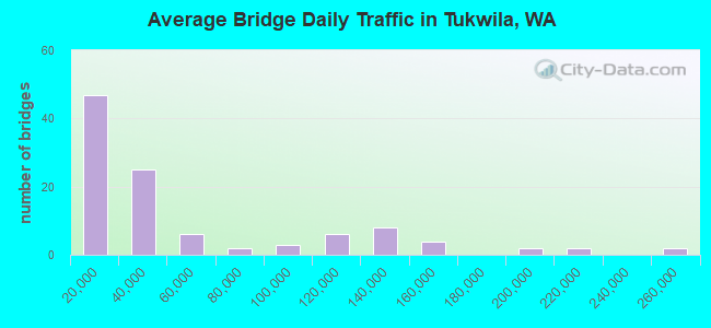
- 5,471,184Total average daily traffic
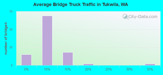
- 407,932Total average daily truck traffic
- National Bridge Inventory (NBI) Registered Bridges for Tukwila
- No street view available for this location
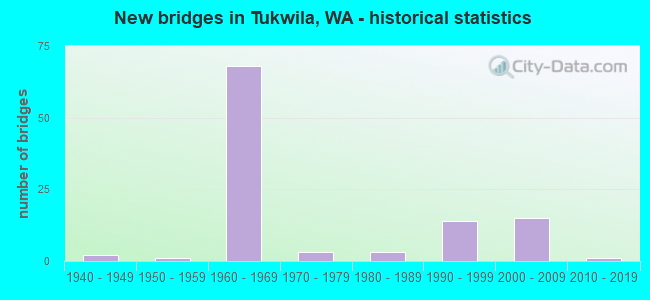
- New bridges - historical statistics
- 21940-1949
- 11950-1959
- 681960-1969
- 31970-1979
- 31980-1989
- 141990-1999
- 152000-2009
- 12010-2019
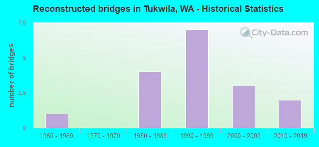
- Reconstructed bridges - Historical Statistics
- 11960-1969
- 01970-1979
- 41980-1989
- 71990-1999
- 32000-2009
- 22010-2019
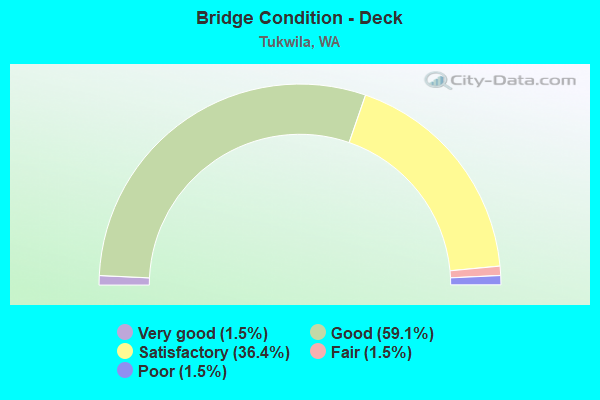
- Bridge Condition - Deck
- 1.5%Very good
- 59.1%Good
- 36.4%Satisfactory
- 1.5%Fair
- 1.5%Poor
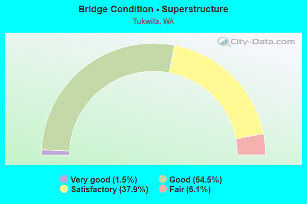
- Bridge Condition - Superstructure
- 1.5%Very good
- 54.5%Good
- 37.9%Satisfactory
- 6.1%Fair
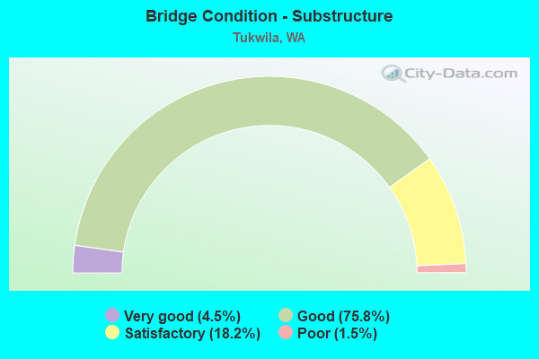
- Bridge Condition - Substructure
- 4.5%Very good
- 75.8%Good
- 18.2%Satisfactory
- 1.5%Poor
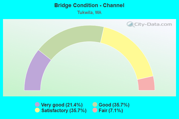
- Bridge Condition - Channel
- 21.4%Very good
- 35.7%Good
- 35.7%Satisfactory
- 7.1%Fair
Find on map >> Show street view
Structure Number: 7618E, Location: 0.5 N JCT SR 900 (Lat: 47.507694, Lng: -122.282167), Route carried "under" structure: Interstate 5, Year Built: 1966, Structure Length: 0. m, Average Daily Traffic: 199,684 (year 2019), Truck Traffic: 8%, Features Intersected: I-5, Facility Carried by Structure: S BOEING ACCESS RD
Minimum Vertical Clearance: 6.43m (21.10ft), Kilometerpoint: 254.292, Lanes on structure: 6, Lanes under structure: 12, Material/Design: Prestressed concrete, Design/Construction: Stringer/Multi-beam, Length of Maximum Span: 24.7m (81.0ft)
Find on map >> Show street view
Structure Number: 7618F, Location: 1.5 N JCT I-405 (Lat: 47.483000, Lng: -122.272139), Route carried "under" structure: Interstate 5, Year Built: 1966, Structure Length: 0. m, Average Daily Traffic: 91,389 (year 2019), Truck Traffic: 8%, Features Intersected: I-5 (SB LANES ONLY)
Minimum Vertical Clearance: 5.92m (19.42ft), Kilometerpoint: 250.913, Lanes on structure: 2, Lanes under structure: 4, Material/Design: Concrete continuous, Design/Construction: Box Beam or Girders - Multiple, Length of Maximum Span: 35.1m (115.2ft)
Find on map >> Show street view
Structure Number: 7618G, Location: 1.6 N JCT SR 599 (Lat: 47.505333, Lng: -122.278944), Route carried "under" structure: Interstate 5, Year Built: 1966, Structure Length: 0. m, Average Daily Traffic: 205,149 (year 2019), Truck Traffic: 8%, Features Intersected: I-5, Facility Carried by Structure: SR 900
Minimum Vertical Clearance: 5.54m (18.18ft), Kilometerpoint: 253.906, Lanes on structure: 2, Lanes under structure: 11, Material/Design: Concrete continuous, Design/Construction: Box Beam or Girders - Multiple, Length of Maximum Span: 45.7m (149.9ft)
Find on map >> Show street view
Structure Number: 7618H, Location: 1.3 N JCT SR 599 (Lat: 47.499778, Lng: -122.274750), Route carried "under" structure: Interstate 5, Year Built: 1966, Structure Length: 0. m, Average Daily Traffic: 203,027 (year 2019), Truck Traffic: 8%, Features Intersected: I-5, Facility Carried by Structure: SR 900
Minimum Vertical Clearance: 6.05m (19.85ft), Kilometerpoint: 253.214, Lanes on structure: 2, Lanes under structure: 10, Material/Design: Concrete continuous, Design/Construction: Box Beam or Girders - Multiple, Length of Maximum Span: 45.7m (149.9ft)
Find on map >> Show street view
Structure Number: 7967A, Location: 1.8 N JCT I-5 (Lat: 47.497028, Lng: -122.293444), Route carried "under" structure: State highway 599, Year Built: 1966, Structure Length: 0. m, Average Daily Traffic: 22,044 (year 2019), Truck Traffic: 9%, Features Intersected: SR 599 SB / SR 99 SB, Facility Carried by Structure: N-N RAMP
Minimum Vertical Clearance: 5.54m (18.18ft), Kilometerpoint: 2.720, Lanes on structure: 1, Lanes under structure: 3, Material/Design: Prestressed concrete, Design/Construction: Stringer/Multi-beam, Length of Maximum Span: 32.3m (106.0ft)
Find on map >> Show street view
Structure Number: 7967B, Location: 1.8 N JCT I-5 (Lat: 47.498278, Lng: -122.294889), Route carried "under" structure: City street 599, Year Built: 1966, Structure Length: 0. m, Average Daily Traffic: 21,114 (year 2016), Truck Traffic: 5%, Features Intersected: TUKWILA INT'L BLVD, Facility Carried by Structure: SR 99
Minimum Vertical Clearance: 6.32m (20.73ft), Kilometerpoint: 0.692, Lanes on structure: 3, Lanes under structure: 5, Material/Design: Prestressed concrete, Design/Construction: Stringer/Multi-beam, Length of Maximum Span: 37.2m (122.0ft)
Find on map >> Show street view
Structure Number: 7967C, Location: 1.8 N JCT I-5 (Lat: 47.497889, Lng: -122.295889), Route carried "under" structure: City street 599, Year Built: 1966, Structure Length: 0. m, Average Daily Traffic: 1,756 (year 1994), Truck Traffic: 5%, Features Intersected: S 116TH WAY, Facility Carried by Structure: S-S RAMP
Minimum Vertical Clearance: 4.83m (15.85ft), Kilometerpoint: 0.032, Lanes on structure: 1, Lanes under structure: 3, Material/Design: Prestressed concrete, Design/Construction: Stringer/Multi-beam, Length of Maximum Span: 25.9m (85.0ft)
Find on map >> Show street view
Structure Number: 7967D, Location: 1.8 N JCT I-5 (Lat: 47.497778, Lng: -122.294972), Route carried "under" structure: City street 599, Year Built: 1966, Structure Length: 0. m, Average Daily Traffic: 21,114 (year 2016), Truck Traffic: 5%, Features Intersected: TUKWILA INT'L BLVD, Facility Carried by Structure: SR 99
Minimum Vertical Clearance: 5.18m (16.99ft), Kilometerpoint: 0.676, Lanes on structure: 2, Lanes under structure: 6, Material/Design: Prestressed concrete, Design/Construction: Stringer/Multi-beam, Length of Maximum Span: 37.8m (124.0ft)
Find on map >> Show street view
Structure Number: 8103C, Location: 1.4 N JCT I-5 (Lat: 47.497164, Lng: -122.287083), Route carried "under" structure: State highway 599, Year Built: 1967, Structure Length: 0. m, Average Daily Traffic: 44,088 (year 2019), Truck Traffic: 9%, Features Intersected: SR 599, Facility Carried by Structure: E MARGINAL WAY
Minimum Vertical Clearance: 5.46m (17.91ft), Kilometerpoint: 2.237, Lanes on structure: 2, Lanes under structure: 4, Material/Design: Prestressed concrete continuous, Design/Construction: Stringer/Multi-beam, Length of Maximum Span: 22.3m (73.2ft)
Find on map >> Show street view
Structure Number: 13354A, Location: 0.8 N JCT I-5 (Lat: 47.462889, Lng: -122.249667), Route carried "under" structure: Interstate 405, Year Built: 1990, Structure Length: 0. m, Average Daily Traffic: 159,240 (year 2019), Truck Traffic: 6%, Features Intersected: I-405, Facility Carried by Structure: 66TH AVE S
Minimum Vertical Clearance: 5.51m (18.08ft), Kilometerpoint: 1.239, Lanes on structure: 5, Lanes under structure: 8, Material/Design: Prestressed concrete continuous, Design/Construction: Stringer/Multi-beam, Length of Maximum Span: 31.7m (104.0ft)
Find on map >> Show street view
Structure Number: 14621B, Location: JCT I-5 (Lat: 47.461083, Lng: -122.263917), Route carried "under" structure: Interstate 405, Year Built: 1996, Structure Length: 0. m, Average Daily Traffic: 38,008 (year 2019), Truck Traffic: 6%, Features Intersected: I-405 NB, RAMPS, Facility Carried by Structure: I-5 HOV LANES
Minimum Vertical Clearance: 6.83m (22.41ft), Kilometerpoint: 0.080, Lanes on structure: 2, Lanes under structure: 1, Material/Design: Prestressed concrete continuous, Design/Construction: Stringer/Multi-beam, Length of Maximum Span: 39.0m (128.0ft)
Find on map >> Show street view
Structure Number: 87426, Location: 0.2 MI E. JCT SR 181 (Lat: 47.441097, Lng: -122.241772), Route carried "under" structure: City street 1320, Year Built: 2001, Structure Length: 0. m, Average Daily Traffic: 10,000 (year 2016), Truck Traffic: 5%, Features Intersected: S 180TH STREET, Facility Carried by Structure: INTERURBAN TRAIL
Minimum Vertical Clearance: 5.92m (19.42ft), Kilometerpoint: 0.001, Lanes under structure: 4, Material/Design: Steel, Design/Construction: Truss - Thru, Length of Maximum Span: 21.3m (69.9ft)
Find on map >> Show street view
Structure Number: 88356, Location: 0.2 M SOUTH OF S144TH ST (Lat: 47.468942, Lng: -122.268789), Route carried "under" structure: City street 1320, Year Built: 2008, Structure Length: 0. m, Average Daily Traffic: 10,000 (year 2015), Truck Traffic: 5%, Features Intersected: SOUTH CENTER BLVD, Facility Carried by Structure: CENTRAL LINK
Minimum Vertical Clearance: 12.78m (41.93ft), Kilometerpoint: 0.001, Lanes under structure: 2, Material/Design: Prestressed concrete, Design/Construction: Box Beam or Girders - Single/Spread, Length of Maximum Span: 42.1m (138.1ft)
Find on map >> Show street view
Structure Number: 8836, Location: 0.1 MI E OF I-5 (Lat: 47.507989, Lng: -122.279114), Route carried "under" structure: Ramp City street 1320, Year Built: 2008, Structure Length: 0. m, Average Daily Traffic: 33,000 (year 2015), Truck Traffic: 15%, Features Intersected: BOEING ACCESS RD s, Facility Carried by Structure: CENTRAL LINK
Minimum Vertical Clearance: 8.08m (26.51ft), Kilometerpoint: 0.001, Lanes under structure: 7, Material/Design: Prestressed concrete, Design/Construction: Box Beam or Girders - Single/Spread, Length of Maximum Span: 66.4m (217.8ft)
Find on map >> Show street view
Structure Number: 88362, Location: .2 MI W OF I-5 (Lat: 47.507058, Lng: -122.289436), Route carried "under" structure: Ramp City street 1320, Year Built: 2008, Structure Length: 0. m, Average Daily Traffic: 116,000 (year 2010), Truck Traffic: 12%, Features Intersected: AIRPRT WAY RAMP, Facility Carried by Structure: CENTRAL LINK
Minimum Vertical Clearance: 7.59m (24.90ft), Kilometerpoint: 0.001, Lanes under structure: 3, Material/Design: Prestressed concrete, Design/Construction: Box Beam or Girders - Single/Spread, Length of Maximum Span: 36.6m (120.1ft)
Find on map >> Show street view
Structure Number: 88363, Location: .3 MI W OF I-5 (Lat: 47.505397, Lng: -122.290244), Route carried "under" structure: City street 1320, Year Built: 2008, Structure Length: 0. m, Average Daily Traffic: 10,000 (year 2015), Truck Traffic: 5%, Features Intersected: E MARGINAL WAY, Facility Carried by Structure: CENTRAL LINK
Minimum Vertical Clearance: 6.45m (21.16ft), Kilometerpoint: 0.001, Lanes under structure: 2, Material/Design: Prestressed concrete, Design/Construction: Box Beam or Girders - Single/Spread, Length of Maximum Span: 39.6m (129.9ft)
Find on map >> Show street view
Structure Number: 88364, Location: .1 MI W OF SR 181 (Lat: 47.498125, Lng: -122.287314), Route carried "under" structure: City street 1320, Year Built: 2008, Structure Length: 0. m, Average Daily Traffic: 10,000 (year 2010), Truck Traffic: 5%, Features Intersected: E MARGINAL WAY, Facility Carried by Structure: CENTRAL LINK
Minimum Vertical Clearance: 5.94m (19.49ft), Kilometerpoint: 0.001, Lanes under structure: 2, Material/Design: Prestressed concrete, Design/Construction: Box Beam or Girders - Single/Spread, Length of Maximum Span: 36.6m (120.1ft)
Find on map >> Show street view
Structure Number: 88365, Location: .4 MI W OF I-5 (Lat: 47.502981, Lng: -122.289350), Route carried "under" structure: City street 1320, Year Built: 2008, Structure Length: 0. m, Average Daily Traffic: 10,000 (year 2010), Truck Traffic: 5%, Features Intersected: S. 112TH STREET, Facility Carried by Structure: CENTRAL LINK
Minimum Vertical Clearance: 5.38m (17.65ft), Kilometerpoint: 0.001, Lanes under structure: 2, Material/Design: Prestressed concrete, Design/Construction: Box Beam or Girders - Single/Spread, Length of Maximum Span: 36.6m (120.1ft)
Find on map >> Show street view
Structure Number: 88367, Location: .1 MI W of SR 599 (Lat: 47.485486, Lng: -122.275947), Route carried "under" structure: City street 1320, Year Built: 2008, Structure Length: 0. m, Average Daily Traffic: 10,000 (year 2010), Truck Traffic: 5%, Features Intersected: GATEWAY DRIVE, Facility Carried by Structure: CENTRAL LINK
Minimum Vertical Clearance: 11.96m (39.24ft), Kilometerpoint: 0.001, Lanes under structure: 4, Material/Design: Prestressed concrete, Design/Construction: Box Beam or Girders - Single/Spread, Length of Maximum Span: 33.5m (109.9ft)
Find on map >> Show street view
Structure Number: 88368, Location: .15 N of SR518 (Lat: 47.465333, Lng: -122.270617), Route carried "under" structure: City street 1320, Year Built: 2008, Structure Length: 0. m, Average Daily Traffic: 5,000 (year 2010), Truck Traffic: 3%, Features Intersected: 51ST STREET BRIDGE, Facility Carried by Structure: CENTRAL LINK
Minimum Vertical Clearance: 5.36m (17.59ft), Kilometerpoint: 0.001, Lanes under structure: 2, Material/Design: Prestressed concrete, Design/Construction: Box Beam or Girders - Single/Spread, Length of Maximum Span: 33.5m (109.9ft)
Find on map >> Show street view
Structure Number: 88369, Location: .1 MI N of SR518 (Lat: 47.464561, Lng: -122.281156), Route carried "under" structure: City street 1320, Year Built: 2008, Structure Length: 0. m, Average Daily Traffic: 5,000 (year 2010), Truck Traffic: 3%, Features Intersected: S 42ND AVE, Facility Carried by Structure: CENTRAL LINK
Minimum Vertical Clearance: 18.82m (61.75ft), Kilometerpoint: 0.001, Lanes under structure: 2, Material/Design: Prestressed concrete, Design/Construction: Box Beam or Girders - Single/Spread, Length of Maximum Span: 36.6m (120.1ft)
Find on map >> Show street view
Structure Number: 8837, Location: .1 MI S of SR 599 (Lat: 47.488572, Lng: -122.272075), Route carried "under" structure: City street 1320, Year Built: 2008, Structure Length: 0. m, Average Daily Traffic: 10,000 (year 2010), Truck Traffic: 5%, Features Intersected: 42nd AVE/MACADAM, Facility Carried by Structure: CENTRAL LINK
Minimum Vertical Clearance: 7.54m (24.74ft), Kilometerpoint: 0.001, Lanes under structure: 2, Material/Design: Prestressed concrete, Design/Construction: Box Beam or Girders - Single/Spread, Length of Maximum Span: 36.6m (120.1ft)
Find on map >> Show street view
Structure Number: 88371, Location: .25 MI W OF I-5 (Lat: 47.506772, Lng: -122.289044), Route carried "under" structure: Ramp City street 1320, Year Built: 2008, Structure Length: 0. m, Average Daily Traffic: 116,000 (year 2010), Truck Traffic: 12%, Features Intersected: AIRPORT WAY RAMP, Facility Carried by Structure: CENTRAL LINK
Minimum Vertical Clearance: 6.38m (20.93ft), Kilometerpoint: 0.001, Lanes under structure: 3, Material/Design: Prestressed concrete, Design/Construction: Box Beam or Girders - Single/Spread, Length of Maximum Span: 33.5m (109.9ft)
Find on map >> Show street view
Structure Number: 88491, Location: 0.13 MILES WEST OF HWY 99 (Lat: 47.450694, Lng: -122.299217), Route carried "under" structure: City street 1278, Year Built: 2008, Structure Length: 0. m, Average Daily Traffic: 15,000 (year 2018), Features Intersected: S 170 ST, Facility Carried by Structure: CENTRAL LINK
Minimum Vertical Clearance: 6.91m (22.67ft), Kilometerpoint: 0.001, Lanes under structure: 4, Material/Design: Concrete continuous, Design/Construction: Box Beam or Girders - Single/Spread, Length of Maximum Span: 78.6m (257.9ft)
Find on map >> Show street view
Structure Number: 88494, Location: 4.9 N JCT SR 516 (Lat: 47.464500, Lng: -122.289389), Route carried "under" structure: City street 99, Year Built: 2008, Structure Length: 0. m, Average Daily Traffic: 30,110 (year 2014), Truck Traffic: 5%, Features Intersected: SR 99/TUKWILA INTL BLVD, Facility Carried by Structure: CENTRAL LINK
Minimum Vertical Clearance: 5.87m (19.26ft), Kilometerpoint: 0.016, Lanes under structure: 6, Material/Design: Prestressed concrete, Design/Construction: Box Beam or Girders - Single/Spread, Length of Maximum Span: 46.9m (153.9ft)