Bridge Statistics for Wichita, Kansas (KS)
Condition, Traffic, Stress, Structural Evaluation, Project Costs
- National Bridge Inventory (NBI) Statistics
- 786Number of bridges
- 16,591ft / 5,057mTotal length
- $13,844,000Total costs
- 9,470,559Total average daily traffic
- 625,083Total average daily truck traffic
- National Bridge Inventory (NBI) Registered Bridges for Wichita
- No street view available for this location
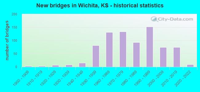
- New bridges - historical statistics
- 41900-1909
- 41910-1919
- 71920-1929
- 81930-1939
- 151940-1949
- 811950-1959
- 1311960-1969
- 1341970-1979
- 931980-1989
- 1521990-1999
- 742000-2009
- 742010-2019
- 92020-2022
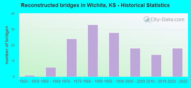
- Reconstructed bridges - Historical Statistics
- 11950-1959
- 61960-1969
- 241970-1979
- 331980-1989
- 281990-1999
- 182000-2009
- 142010-2019
- 182020-2022
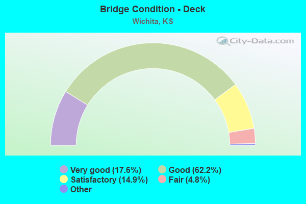
- Bridge Condition - Deck
- 17.6%Very good
- 62.2%Good
- 14.9%Satisfactory
- 4.8%Fair
- 0.5%Poor
- 0.2%Serious
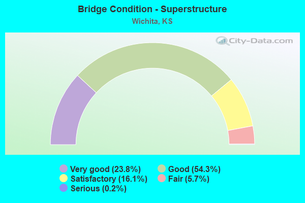
- Bridge Condition - Superstructure
- 23.8%Very good
- 54.3%Good
- 16.1%Satisfactory
- 5.7%Fair
- 0.2%Serious
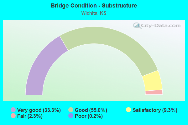
- Bridge Condition - Substructure
- 33.3%Very good
- 55.0%Good
- 9.3%Satisfactory
- 2.3%Fair
- 0.2%Poor
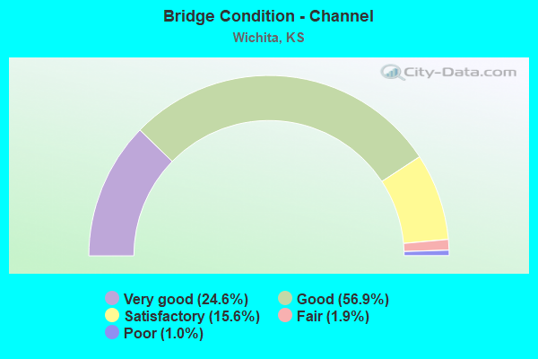
- Bridge Condition - Channel
- 24.6%Very good
- 56.9%Good
- 15.6%Satisfactory
- 1.9%Fair
- 1.0%Poor
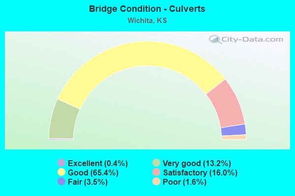
- Bridge Condition - Culverts
- 0.4%Excellent
- 13.2%Very good
- 65.4%Good
- 16.0%Satisfactory
- 3.5%Fair
- 1.6%Poor
Find on map >> Show street view
Structure Number: 999905400873021, Location: KELLOGG & GROVE (Lat: 37.678611, Lng: -97.308056), Route carried "on" structure: Ramp State highway 38, Year Built: 1976, Status: Open, Structure Length: 5.60m (18.37ft), Average Daily Traffic: 9,540 (year 2020), Truck Traffic: 5%, Average Future Daily Traffic: 71,448 (year 2041), Design Load: HS 20, Features Intersected: GROVE ST, Facility Carried by Structure: RAMP N TO E
Minimum Vertical Clearance: 30.47m (99.97ft), Kilometerpoint: 1.292, Lanes on structure: 2, Lanes under structure: 4, Owner: State Highway Agency, Approaching Roadway Width: 11.0m (36.1ft), Skew: 2 degrees, Material/Design: Concrete continuous, Design/Construction: Slab, Number Of Spans In Main Unit: 4, Length of Maximum Span: 15.6m (51.2ft), Curb-To-Curb Width: 11.0m (36.1ft), Out-to-Out Width: 11.7m (38.4ft)
Condition: Deck: Good, Superstructure: Very good, Substructure: Very good, Operating Rating: 72.6 metric tons, Method Used To Determine Operating Rating: Load Factor (LF), Inventory Rating: 43.5 metric tons, Method Used To Determine Inventory Rating: Load Factor (LF), Structural Evaluation: Equal to present desirable criteria, Deck Geometry: Better than present minimum criteria, Underclear: Somewhat better than minimum adequacy, Approach Roadway Alignment: Better than present minimum criteria, Length Of Structure Improvement: 18.37m (60.27ft), Designated Inspection Frequency: Every 24 months, Inspection Date: September 2020, Deck Structure Type: Concrete Cast-file-Place, Wearing Surface/Protective System: Wearing Surface: Epoxy Overlay
Find on map >> Show street view
Structure Number: 999905400873031, Location: US54 & HYDRAULIC AVE (Lat: 37.678889, Lng: -97.317222), Route carried "on" structure: Ramp State highway 38, Year Built: 1976, Status: Open, Structure Length: 4.97m (16.31ft), Average Daily Traffic: 18,375 (year 2020), Truck Traffic: 5%, Average Future Daily Traffic: 68,690 (year 2041), Design Load: HS 20, Features Intersected: HYDRAULIC AVE, Facility Carried by Structure: 135N to 54W
Minimum Vertical Clearance: 30.47m (99.97ft), Kilometerpoint: 0.895, Lanes on structure: 1, Lanes under structure: 4, Owner: State Highway Agency, Approaching Roadway Width: 11.0m (36.1ft), Skew: 1 degrees, Material/Design: Concrete continuous, Design/Construction: Box Beam or Girders - Multiple, Number Of Spans In Main Unit: 3, Length of Maximum Span: 22.4m (73.5ft), Curb-To-Curb Width: 11.0m (36.1ft), Out-to-Out Width: 11.7m (38.4ft)
Condition: Deck: Good, Superstructure: Good, Substructure: Good, Operating Rating: 81.4 metric tons, Method Used To Determine Operating Rating: Load Factor (LF), Inventory Rating: 48.7 metric tons, Method Used To Determine Inventory Rating: Load Factor (LF), Structural Evaluation: Better than present minimum criteria, Deck Geometry: Superior to present desirable criteria, Underclear: Somewhat better than minimum adequacy, Approach Roadway Alignment: Better than present minimum criteria, Length Of Structure Improvement: 16.30m (53.48ft), Designated Inspection Frequency: Every 24 months, Inspection Date: September 2020, Deck Structure Type: Concrete Cast-file-Place, Wearing Surface/Protective System: Wearing Surface: Epoxy Overlay
Find on map >> Show street view
Structure Number: 999905400873131, Location: 0.80 MI E JCT I135/US54 (Lat: 37.679444, Lng: -97.298611), Route carried "on" structure: US 54, Year Built: 1977, Status: Open, Structure Length: 6.11m (20.05ft), Average Daily Traffic: 47,886 (year 2020), Truck Traffic: 3%, Average Future Daily Traffic: 67,085 (year 2041), Design Load: HS 20, Features Intersected: HILLSIDE AVE
Minimum Vertical Clearance: 30.47m (99.97ft), Kilometerpoint: 45.281, Lanes on structure: 3, Lanes under structure: 4, Base Highway Network: Yes, Owner: State Highway Agency, Approaching Roadway Width: 15.8m (51.8ft), Material/Design: Steel continuous, Design/Construction: Stringer/Multi-beam, Number Of Spans In Main Unit: 3, Length of Maximum Span: 30.2m (99.1ft), Curb-To-Curb Width: 15.8m (51.8ft), Out-to-Out Width: 16.6m (54.5ft)
Condition: Deck: Good, Superstructure: Fair, Substructure: Satisfactory, Operating Rating: 59.9 metric tons, Method Used To Determine Operating Rating: Load Factor (LF), Inventory Rating: 35.4 metric tons, Method Used To Determine Inventory Rating: Load Factor (LF), Structural Evaluation: Somewhat better than minimum adequacy, Deck Geometry: Somewhat better than minimum adequacy, Underclear: Somewhat better than minimum adequacy, Approach Roadway Alignment: Equal to present desirable criteria, Length Of Structure Improvement: 20.05m (65.78ft), Designated Inspection Frequency: Every 24 months, Inspection Date: September 2020, Deck Structure Type: Concrete Cast-file-Place, Wearing Surface/Protective System: Wearing Surface: Low Slump Concrete
Find on map >> Show street view
Structure Number: 999905400873141, Location: 0.80 MI E JCT I135/US54 (Lat: 37.679167, Lng: -97.298611), Route carried "on" structure: US 54, Year Built: 1977, Status: Open, Structure Length: 6.11m (20.05ft), Average Daily Traffic: 47,886 (year 2020), Truck Traffic: 3%, Average Future Daily Traffic: 67,085 (year 2041), Design Load: HS 20, Features Intersected: HILLSIDE AVE
Minimum Vertical Clearance: 30.47m (99.97ft), Kilometerpoint: 45.277, Lanes on structure: 4, Lanes under structure: 4, Base Highway Network: Yes, Owner: State Highway Agency, Approaching Roadway Width: 18.3m (60.0ft), Material/Design: Steel continuous, Design/Construction: Stringer/Multi-beam, Number Of Spans In Main Unit: 3, Length of Maximum Span: 30.2m (99.1ft), Curb-To-Curb Width: 18.3m (60.0ft), Out-to-Out Width: 19.0m (62.3ft)
Condition: Deck: Good, Superstructure: Satisfactory, Substructure: Satisfactory, Operating Rating: 63.5 metric tons, Method Used To Determine Operating Rating: Load Factor (LF), Inventory Rating: 38.1 metric tons, Method Used To Determine Inventory Rating: Load Factor (LF), Structural Evaluation: Equal to present minimum criteria, Deck Geometry: Meets minimum limits, Underclear: Somewhat better than minimum adequacy, Approach Roadway Alignment: Equal to present desirable criteria, Length Of Structure Improvement: 20.05m (65.78ft), Designated Inspection Frequency: Every 24 months, Inspection Date: September 2020, Deck Structure Type: Concrete Cast-file-Place, Wearing Surface/Protective System: Wearing Surface: Low Slump Concrete
Find on map >> Show street view
Structure Number: 999905400873171, Location: 0.25 MI E TOPEKA ST (Lat: 37.678611, Lng: -97.329444), Route carried "on" structure: US 54, Year Built: 1979, Status: Open, Structure Length: 58.36m (191.47ft), Average Daily Traffic: 51,172 (year 2020), Truck Traffic: 4%, Average Future Daily Traffic: 68,921 (year 2041), Design Load: HS 20, Features Intersected: BNSF & KO RR & STREETS
Minimum Vertical Clearance: 30.47m (99.97ft), Kilometerpoint: 42.588, Lanes on structure: 4, Lanes under structure: 8, Base Highway Network: Yes, Owner: State Highway Agency, Approaching Roadway Width: 15.8m (51.8ft), Material/Design: Steel continuous, Design/Construction: Stringer/Multi-beam, Number Of Spans In Main Unit: 24, Length of Maximum Span: 37.2m (122.0ft), Curb-To-Curb Width: 18.3m (60.0ft), Out-to-Out Width: 19.1m (62.7ft)
Condition: Deck: Good, Superstructure: Good, Substructure: Good, Operating Rating: 56.3 metric tons, Method Used To Determine Operating Rating: Load Factor (LF), Inventory Rating: 33.7 metric tons, Method Used To Determine Inventory Rating: Load Factor (LF), Structural Evaluation: Better than present minimum criteria, Deck Geometry: Meets minimum limits, Underclear: High priority of corrective action, Approach Roadway Alignment: Equal to present desirable criteria, Length Of Structure Improvement: 191.46m (628.15ft), Designated Inspection Frequency: Every 24 months, Inspection Date: September 2020, Deck Structure Type: Concrete Cast-file-Place, Wearing Surface/Protective System: Wearing Surface: Low Slump Concrete
Find on map >> Show street view
Structure Number: 999905400873311, Location: JT 54 & S MID CONTINENT (Lat: 37.672222, Lng: -97.428611), Route carried "on" structure: City street 6125, Year Built: 1980, Status: Open, Structure Length: 7.47m (24.51ft), Average Daily Traffic: 6,601 (year 2020), Truck Traffic: 8%, Average Future Daily Traffic: 7,440 (year 2041), Design Load: HS 20, Features Intersected: US54 EB/WB, Facility Carried by Structure: SB S MID CONT RD
Minimum Vertical Clearance: 30.47m (99.97ft), Kilometerpoint: 1.719, Lanes on structure: 3, Lanes under structure: 6, Base Highway Network: Yes, Owner: State Highway Agency, Approaching Roadway Width: 12.2m (40.0ft), Material/Design: Steel continuous, Design/Construction: Box Beam or Girders - Multiple, Number Of Spans In Main Unit: 2, Number Of Approach Spans: 2, Length of Maximum Span: 23.5m (77.1ft), Curb-To-Curb Width: 12.2m (40.0ft), Out-to-Out Width: 13.0m (42.7ft)
Condition: Deck: Good, Superstructure: Good, Substructure: Good, Operating Rating: 52.6 metric tons, Method Used To Determine Operating Rating: Load Factor (LF), Inventory Rating: 31.8 metric tons, Method Used To Determine Inventory Rating: Load Factor (LF), Structural Evaluation: Better than present minimum criteria, Deck Geometry: High priority of corrective action, Underclear: Equal to present minimum criteria, Approach Roadway Alignment: Somewhat better than minimum adequacy, Length Of Structure Improvement: 24.50m (80.38ft), Designated Inspection Frequency: Every 24 months, Inspection Date: September 2020, Deck Structure Type: Concrete Cast-file-Place, Wearing Surface/Protective System: Wearing Surface: Low Slump Concrete
Find on map >> Show street view
Structure Number: 999905400873341, Location: JT U54 & S MID CONTINENT (Lat: 37.672500, Lng: -97.427500), Route carried "on" structure: City street 6125, Year Built: 1980, Status: Open, Structure Length: 7.16m (23.49ft), Average Daily Traffic: 4,066 (year 2020), Truck Traffic: 6%, Average Future Daily Traffic: 4,961 (year 2041), Design Load: HS 20, Features Intersected: US54 WB/EB, Facility Carried by Structure: NB S MID CONT RD
Minimum Vertical Clearance: 5.05m (16.57ft), Kilometerpoint: 1.736, Lanes on structure: 3, Lanes under structure: 6, Base Highway Network: Yes, Owner: State Highway Agency, Approaching Roadway Width: 12.2m (40.0ft), Material/Design: Steel continuous, Design/Construction: Box Beam or Girders - Multiple, Number Of Spans In Main Unit: 2, Number Of Approach Spans: 2, Length of Maximum Span: 23.5m (77.1ft), Curb-To-Curb Width: 12.2m (40.0ft), Out-to-Out Width: 13.0m (42.7ft)
Condition: Deck: Good, Superstructure: Good, Substructure: Good, Operating Rating: 52.6 metric tons, Method Used To Determine Operating Rating: Load Factor (LF), Inventory Rating: 31.8 metric tons, Method Used To Determine Inventory Rating: Load Factor (LF), Structural Evaluation: Better than present minimum criteria, Deck Geometry: High priority of corrective action, Underclear: Somewhat better than minimum adequacy, Approach Roadway Alignment: Somewhat better than minimum adequacy, Length Of Structure Improvement: 23.50m (77.10ft), Designated Inspection Frequency: Every 24 months, Inspection Date: September 2020, Deck Structure Type: Concrete Cast-file-Place, Wearing Surface/Protective System: Wearing Surface: Low Slump Concrete
Find on map >> Show street view
Structure Number: 999905400873361, Location: RAMP,WB54-SB MIDCN (Lat: 37.671944, Lng: -97.427778), Route carried "on" structure: Ramp State highway 10, Year Built: 1980, Status: Open, Structure Length: 27.89m (91.50ft), Average Daily Traffic: 10,860 (year 2022), Truck Traffic: 11%, Design Load: HS 20, Features Intersected: US54& NB MID-CONT. DR, Facility Carried by Structure: RP,WB54-SB MIDCN
Minimum Vertical Clearance: 30.47m (99.97ft), Kilometerpoint: 0.259, Lanes on structure: 1, Lanes under structure: 11, Base Highway Network: Yes (Inventory Route: 8740010, Subroute: 98), Owner: State Highway Agency, Approaching Roadway Width: 7.3m (24.0ft), Material/Design: Steel continuous, Design/Construction: Box Beam or Girders - Multiple, Number Of Spans In Main Unit: 6, Number Of Approach Spans: 3, Length of Maximum Span: 41.1m (134.8ft), Curb-To-Curb Width: 7.3m (24.0ft), Out-to-Out Width: 8.4m (27.6ft)
Condition: Deck: Good, Superstructure: Good, Substructure: Good, Operating Rating: 52.6 metric tons, Method Used To Determine Operating Rating: Load Factor (LF), Inventory Rating: 31.8 metric tons, Method Used To Determine Inventory Rating: Load Factor (LF), Structural Evaluation: Better than present minimum criteria, Deck Geometry: Better than present minimum criteria, Underclear: High priority of corrective action, Approach Roadway Alignment: Better than present minimum criteria, Length Of Structure Improvement: 91.51m (300.23ft), Designated Inspection Frequency: Every 12 months, Critical Feature Inspection Frequency: Every 24 months, Inspection Date: August 2021, Critical Feature Inspection Date: October 2020, Deck Structure Type: Concrete Cast-file-Place, Wearing Surface/Protective System: Wearing Surface: Epoxy Overlay
Find on map >> Show street view
Structure Number: 999905400873531, Location: US54 & WEST ST (Lat: 37.673611, Lng: -97.389167), Route carried "on" structure: US 54, Year Built: 1989, Status: Open, Structure Length: 16.37m (53.71ft), Average Daily Traffic: 38,731 (year 2020), Truck Traffic: 5%, Average Future Daily Traffic: 57,552 (year 2041), Design Load: HS 20, Features Intersected: WEST ST. & US54 RAMP
Minimum Vertical Clearance: 30.47m (99.97ft), Kilometerpoint: 37.243, Lanes on structure: 3, Lanes under structure: 8, Base Highway Network: Yes, Owner: State Highway Agency, Approaching Roadway Width: 13.4m (44.0ft), Material/Design: Steel continuous, Design/Construction: Box Beam or Girders - Multiple, Number Of Spans In Main Unit: 3, Length of Maximum Span: 69.5m (228.0ft), Curb-To-Curb Width: 13.2m (43.3ft), Out-to-Out Width: 13.9m (45.6ft)
Condition: Deck: Good, Superstructure: Very good, Substructure: Very good, Operating Rating: 94.3 metric tons, Method Used To Determine Operating Rating: Load Factor (LF), Inventory Rating: 48.1 metric tons, Method Used To Determine Inventory Rating: Load Factor (LF), Structural Evaluation: Equal to present desirable criteria, Deck Geometry: Meets minimum limits, Underclear: Superior to present desirable criteria, Approach Roadway Alignment: Better than present minimum criteria, Length Of Structure Improvement: 53.70m (176.18ft), Designated Inspection Frequency: Every 24 months, Inspection Date: September 2020, Deck Structure Type: Corrugated Steel, Wearing Surface/Protective System: Wearing Surface: Epoxy Overlay
Find on map >> Show street view
Structure Number: 999905400873541, Location: US54 & WEST ST (Lat: 37.673333, Lng: -97.389167), Route carried "on" structure: US 54, Year Built: 1989, Year Reconstructed: 2018, Status: Open, Structure Length: 16.37m (53.71ft), Average Daily Traffic: 38,731 (year 2020), Truck Traffic: 5%, Average Future Daily Traffic: 57,552 (year 2041), Design Load: HS 20, Features Intersected: WEST ST. & US54 RAMP
Minimum Vertical Clearance: 30.47m (99.97ft), Kilometerpoint: 37.240, Lanes on structure: 5, Lanes under structure: 8, Base Highway Network: Yes, Owner: State Highway Agency, Approaching Roadway Width: 24.4m (80.1ft), Material/Design: Steel continuous, Design/Construction: Box Beam or Girders - Multiple, Number Of Spans In Main Unit: 3, Length of Maximum Span: 69.5m (228.0ft), Curb-To-Curb Width: 24.6m (80.7ft), Out-to-Out Width: 25.2m (82.7ft)
Condition: Deck: Good, Superstructure: Good, Substructure: Good, Inventory Rating: 49.9 metric tons, Method Used To Determine Inventory Rating: Load Factor (LF), Structural Evaluation: Better than present minimum criteria, Deck Geometry: Better than present minimum criteria, Underclear: Better than present minimum criteria, Approach Roadway Alignment: Better than present minimum criteria, Length Of Structure Improvement: 53.70m (176.18ft), Designated Inspection Frequency: Every 24 months, Inspection Date: September 2020, Deck Structure Type: Corrugated Steel, Wearing Surface/Protective System: Wearing Surface: Epoxy Overlay
Find on map >> Show street view
Structure Number: 999905400873631, Location: 1.37 MI W BUTLER CO LINE (Lat: 37.679444, Lng: -97.178056), Route carried "on" structure: US 54, Year Built: 1990, Status: Open, Structure Length: 3.12m (10.24ft), Average Daily Traffic: 16,696 (year 2020), Truck Traffic: 5%, Average Future Daily Traffic: 23,390 (year 2041), Design Load: HS 20, Features Intersected: SPRING BRANCH
Minimum Vertical Clearance: 30.47m (99.97ft), Kilometerpoint: 55.930, Lanes on structure: 2, Base Highway Network: Yes, Owner: State Highway Agency, Approaching Roadway Width: 12.2m (40.0ft), Material/Design: Concrete continuous, Design/Construction: Slab, Number Of Spans In Main Unit: 3, Length of Maximum Span: 12.2m (40.0ft), Curb-To-Curb Width: 12.2m (40.0ft), Out-to-Out Width: 12.8m (42.0ft)
Condition: Deck: Good, Superstructure: Good, Substructure: Very good, Channel: Very good, Operating Rating: 78.0 metric tons, Method Used To Determine Operating Rating: Load Factor (LF), Inventory Rating: 46.3 metric tons, Method Used To Determine Inventory Rating: Load Factor (LF), Structural Evaluation: Better than present minimum criteria, Deck Geometry: Better than present minimum criteria, Waterway Adequacy: Equal to present desirable criteria, Approach Roadway Alignment: Equal to present desirable criteria, Length Of Structure Improvement: 10.25m (33.63ft), Designated Inspection Frequency: Every 24 months, Inspection Date: September 2020, Wearing Surface/Protective System: Wearing Surface: Monolithic Concrete, Deck Protection: Epoxy Coated Reinforcing
Find on map >> Show street view
Structure Number: 999905400873641, Location: 1.38 MI W BUTLER CO LINE (Lat: 37.679167, Lng: -97.178056), Route carried "on" structure: US 54, Year Built: 1990, Year Reconstructed: 1991, Status: Open, Structure Length: 3.12m (10.24ft), Average Daily Traffic: 16,696 (year 2020), Truck Traffic: 5%, Average Future Daily Traffic: 23,390 (year 2041), Design Load: HS 20, Features Intersected: SPRING BRANCH
Minimum Vertical Clearance: 30.47m (99.97ft), Kilometerpoint: 55.925, Lanes on structure: 2, Base Highway Network: Yes, Owner: State Highway Agency, Approaching Roadway Width: 12.2m (40.0ft), Material/Design: Concrete continuous, Design/Construction: Slab, Number Of Spans In Main Unit: 3, Length of Maximum Span: 12.2m (40.0ft), Curb-To-Curb Width: 15.2m (49.9ft), Out-to-Out Width: 15.8m (51.8ft)
Condition: Deck: Good, Superstructure: Good, Substructure: Good, Channel: Good, Operating Rating: 78.0 metric tons, Method Used To Determine Operating Rating: Load Factor (LF), Inventory Rating: 46.3 metric tons, Method Used To Determine Inventory Rating: Load Factor (LF), Structural Evaluation: Better than present minimum criteria, Deck Geometry: Superior to present desirable criteria, Waterway Adequacy: Equal to present desirable criteria, Approach Roadway Alignment: Equal to present desirable criteria, Length Of Structure Improvement: 10.25m (33.63ft), Designated Inspection Frequency: Every 24 months, Inspection Date: September 2020, Wearing Surface/Protective System: Wearing Surface: Monolithic Concrete, Deck Protection: Epoxy Coated Reinforcing
Find on map >> Show street view
Structure Number: 999905400873651, Location: 0.23 MI W OF BUTLER CL (Lat: 37.679444, Lng: -97.157222), Route carried "on" structure: US 54, Year Built: 1990, Status: Open, Structure Length: 3.73m (12.24ft), Average Daily Traffic: 10,328 (year 2020), Truck Traffic: 8%, Average Future Daily Traffic: 14,469 (year 2041), Design Load: HS 20, Features Intersected: FOURMILE CREEK
Minimum Vertical Clearance: 30.47m (99.97ft), Kilometerpoint: 57.764, Lanes on structure: 2, Base Highway Network: Yes, Owner: State Highway Agency, Approaching Roadway Width: 12.2m (40.0ft), Material/Design: Concrete continuous, Design/Construction: Slab, Number Of Spans In Main Unit: 3, Length of Maximum Span: 14.6m (47.9ft), Curb-To-Curb Width: 12.2m (40.0ft), Out-to-Out Width: 12.8m (42.0ft)
Condition: Deck: Good, Superstructure: Good, Substructure: Good, Channel: Good, Operating Rating: 82.6 metric tons, Method Used To Determine Operating Rating: Load Factor (LF), Inventory Rating: 49.0 metric tons, Method Used To Determine Inventory Rating: Load Factor (LF), Structural Evaluation: Better than present minimum criteria, Deck Geometry: Better than present minimum criteria, Waterway Adequacy: Somewhat better than minimum adequacy, Approach Roadway Alignment: Equal to present desirable criteria, Length Of Structure Improvement: 12.25m (40.19ft), Designated Inspection Frequency: Every 24 months, Inspection Date: September 2020, Wearing Surface/Protective System: Wearing Surface: Monolithic Concrete, Deck Protection: Epoxy Coated Reinforcing
Find on map >> Show street view
Structure Number: 999905400873661, Location: 0.10 MI W OF BUTLER CL (Lat: 37.679167, Lng: -97.157222), Route carried "on" structure: US 54, Year Built: 1990, Status: Open, Structure Length: 3.73m (12.24ft), Average Daily Traffic: 10,328 (year 2020), Truck Traffic: 8%, Average Future Daily Traffic: 14,469 (year 2041), Design Load: HS 20, Features Intersected: FOURMILE CREEK
Minimum Vertical Clearance: 30.47m (99.97ft), Kilometerpoint: 57.759, Lanes on structure: 2, Base Highway Network: Yes, Owner: State Highway Agency, Approaching Roadway Width: 12.2m (40.0ft), Material/Design: Concrete continuous, Design/Construction: Slab, Number Of Spans In Main Unit: 3, Length of Maximum Span: 14.6m (47.9ft), Curb-To-Curb Width: 12.2m (40.0ft), Out-to-Out Width: 12.8m (42.0ft)
Condition: Deck: Good, Superstructure: Good, Substructure: Very good, Channel: Good, Operating Rating: 82.6 metric tons, Method Used To Determine Operating Rating: Load Factor (LF), Inventory Rating: 49.0 metric tons, Method Used To Determine Inventory Rating: Load Factor (LF), Structural Evaluation: Better than present minimum criteria, Deck Geometry: Better than present minimum criteria, Waterway Adequacy: Somewhat better than minimum adequacy, Approach Roadway Alignment: Equal to present desirable criteria, Length Of Structure Improvement: 12.25m (40.19ft), Designated Inspection Frequency: Every 24 months, Inspection Date: September 2020, Wearing Surface/Protective System: Wearing Surface: Monolithic Concrete, Deck Protection: Epoxy Coated Reinforcing
Find on map >> Show street view
Structure Number: 999905400873671, Location: 0.91 MI E 143RD ST (Lat: 37.679444, Lng: -97.154444), Route carried "on" structure: US 54, Year Built: 1990, Status: Open, Structure Length: 3.43m (11.25ft), Average Daily Traffic: 10,328 (year 2020), Truck Traffic: 8%, Average Future Daily Traffic: 14,469 (year 2041), Design Load: HS 20, Features Intersected: FOURMILE CREEK DRAINAGE
Minimum Vertical Clearance: 30.47m (99.97ft), Kilometerpoint: 58.015, Lanes on structure: 2, Base Highway Network: Yes, Owner: State Highway Agency, Approaching Roadway Width: 12.2m (40.0ft), Material/Design: Concrete continuous, Design/Construction: Slab, Number Of Spans In Main Unit: 3, Length of Maximum Span: 13.4m (44.0ft), Curb-To-Curb Width: 12.2m (40.0ft), Out-to-Out Width: 12.8m (42.0ft)
Condition: Deck: Good, Superstructure: Good, Substructure: Very good, Channel: Good, Operating Rating: 77.1 metric tons, Method Used To Determine Operating Rating: Load Factor (LF), Inventory Rating: 46.3 metric tons, Method Used To Determine Inventory Rating: Load Factor (LF), Structural Evaluation: Better than present minimum criteria, Deck Geometry: Better than present minimum criteria, Waterway Adequacy: Equal to present desirable criteria, Approach Roadway Alignment: Equal to present desirable criteria, Length Of Structure Improvement: 11.26m (36.94ft), Designated Inspection Frequency: Every 24 months, Inspection Date: September 2020, Wearing Surface/Protective System: Wearing Surface: Monolithic Concrete, Deck Protection: Epoxy Coated Reinforcing
Find on map >> Show street view
Structure Number: 999905400873681, Location: 0.90 MI E 143RD ST EB (Lat: 37.679167, Lng: -97.154444), Route carried "on" structure: US 54, Year Built: 1990, Year Reconstructed: 2012, Status: Open, Structure Length: 3.43m (11.25ft), Average Daily Traffic: 10,328 (year 2020), Truck Traffic: 8%, Average Future Daily Traffic: 14,469 (year 2041), Design Load: HS 20, Features Intersected: FOURMILE CREEK DRAINAGE
Minimum Vertical Clearance: 30.47m (99.97ft), Kilometerpoint: 58.010, Lanes on structure: 3, Base Highway Network: Yes, Owner: State Highway Agency, Approaching Roadway Width: 12.2m (40.0ft), Material/Design: Concrete continuous, Design/Construction: Slab, Number Of Spans In Main Unit: 3, Length of Maximum Span: 13.4m (44.0ft), Curb-To-Curb Width: 14.6m (47.9ft), Out-to-Out Width: 15.2m (49.9ft)
Condition: Deck: Good, Superstructure: Good, Substructure: Very good, Channel: Very good, Operating Rating: 77.1 metric tons, Method Used To Determine Operating Rating: Load Factor (LF), Inventory Rating: 46.3 metric tons, Method Used To Determine Inventory Rating: Load Factor (LF), Structural Evaluation: Better than present minimum criteria, Deck Geometry: Meets minimum limits, Waterway Adequacy: Equal to present desirable criteria, Approach Roadway Alignment: Equal to present desirable criteria, Length Of Structure Improvement: 11.25m (36.91ft), Designated Inspection Frequency: Every 24 months, Inspection Date: September 2020, Wearing Surface/Protective System: Wearing Surface: Monolithic Concrete, Deck Protection: Epoxy Coated Reinforcing
Find on map >> Show street view
Structure Number: 999905400873741, Location: 0.39 MI E SYCAMORE ST (Lat: 37.679167, Lng: -97.339444), Route carried "on" structure: Ramp State highway 15, Year Built: 1994, Status: Open, Structure Length: 9.01m (29.56ft), Average Daily Traffic: 7,520 (year 2020), Truck Traffic: 5%, Average Future Daily Traffic: 76,097 (year 2041), Design Load: HS 25 or greater, Features Intersected: WATER ST, Facility Carried by Structure: US-54 NW RMP,WB ON
Minimum Vertical Clearance: 30.47m (99.97ft), Kilometerpoint: 0.117, Lanes on structure: 1, Lanes under structure: 2, Base Highway Network: Yes (Inventory Route: 8740015, Subroute: 2), Owner: State Highway Agency, Approaching Roadway Width: 8.8m (28.9ft), Material/Design: Prestressed concrete continuous, Design/Construction: Box Beam or Girders - Multiple, Number Of Spans In Main Unit: 3, Length of Maximum Span: 32.0m (105.0ft), Curb-To-Curb Width: 7.9m (25.9ft), Out-to-Out Width: 8.7m (28.5ft)
Condition: Deck: Good, Superstructure: Good, Substructure: Good, Operating Rating: 71.7 metric tons, Method Used To Determine Operating Rating: Load Factor (LF), Inventory Rating: 42.6 metric tons, Method Used To Determine Inventory Rating: Load Factor (LF), Structural Evaluation: Better than present minimum criteria, Deck Geometry: Equal to present desirable criteria, Underclear: Equal to present minimum criteria, Approach Roadway Alignment: Better than present minimum criteria, Length Of Structure Improvement: 29.57m (97.01ft), Designated Inspection Frequency: Every 24 months, Inspection Date: September 2020, Deck Structure Type: Concrete Precast Panels, Wearing Surface/Protective System: Wearing Surface: Latex Concrete, Deck Protection: Epoxy Coated Reinforcing
Find on map >> Show street view
Structure Number: 999905400873751, Location: 0.45 MI E SYCAMORE ST (Lat: 37.678889, Lng: -97.338889), Route carried "on" structure: US 54, Year Built: 1994, Status: Open, Structure Length: 88.64m (290.81ft), Average Daily Traffic: 51,172 (year 2020), Truck Traffic: 4%, Average Future Daily Traffic: 68,921 (year 2041), Design Load: HS 25 or greater, Features Intersected: CITY STS/ARKANSAS RIVER
Minimum Vertical Clearance: 30.47m (99.97ft), Kilometerpoint: 41.766, Lanes on structure: 3, Lanes under structure: 25, Base Highway Network: Yes, Owner: State Highway Agency, Approaching Roadway Width: 16.5m (54.1ft), Material/Design: Prestressed concrete continuous, Design/Construction: Box Beam or Girders - Multiple, Number Of Spans In Main Unit: 27, Length of Maximum Span: 50.3m (165.0ft), Curb-To-Curb Width: 16.5m (54.1ft), Out-to-Out Width: 17.3m (56.8ft)
Condition: Deck: Good, Superstructure: Good, Substructure: Good, Channel: Good, Operating Rating: 40.8 metric tons, Method Used To Determine Operating Rating: Load Factor (LF), Inventory Rating: 25.4 metric tons, Method Used To Determine Inventory Rating: Load Factor (LF), Structural Evaluation: Equal to present minimum criteria, Deck Geometry: Equal to present minimum criteria, Underclear: High priority of corrective action, Waterway Adequacy: Better than present minimum criteria, Approach Roadway Alignment: Equal to present desirable criteria, Length Of Structure Improvement: 290.80m (954.07ft), Designated Inspection Frequency: Every 24 months, Inspection Date: September 2020, Deck Structure Type: Concrete Precast Panels, Wearing Surface/Protective System: Wearing Surface: Latex Concrete, Deck Protection: Epoxy Coated Reinforcing
Find on map >> Show street view
Structure Number: 999905400873761, Location: 0.44 MI E SYCAMORE ST (Lat: 37.678611, Lng: -97.338889), Route carried "on" structure: US 54, Year Built: 1994, Status: Open, Structure Length: 88.64m (290.81ft), Average Daily Traffic: 51,172 (year 2020), Truck Traffic: 4%, Average Future Daily Traffic: 68,921 (year 2041), Design Load: HS 25 or greater, Features Intersected: CITY STS/ARKANSAS RIVER
Minimum Vertical Clearance: 30.47m (99.97ft), Kilometerpoint: 41.761, Lanes on structure: 3, Lanes under structure: 25, Base Highway Network: Yes, Owner: State Highway Agency, Approaching Roadway Width: 16.5m (54.1ft), Navigation Control: Yes ( Vertical Clearance: 10.3m (33.8ft), Horizontal Clearance: 45.7m (149.9ft)), Material/Design: Prestressed concrete continuous, Design/Construction: Box Beam or Girders - Multiple, Number Of Spans In Main Unit: 27, Length of Maximum Span: 48.8m (160.1ft), Curb-To-Curb Width: 16.5m (54.1ft), Out-to-Out Width: 17.3m (56.8ft)
Condition: Deck: Good, Superstructure: Good, Substructure: Good, Channel: Good, Operating Rating: 41.7 metric tons, Method Used To Determine Operating Rating: Load Factor (LF), Inventory Rating: 27.2 metric tons, Method Used To Determine Inventory Rating: Load Factor (LF), Structural Evaluation: Equal to present minimum criteria, Deck Geometry: Equal to present minimum criteria, Underclear: Better than present minimum criteria, Waterway Adequacy: Better than present minimum criteria, Approach Roadway Alignment: Equal to present desirable criteria, Length Of Structure Improvement: 290.80m (954.07ft), Designated Inspection Frequency: Every 24 months, Inspection Date: September 2020, Deck Structure Type: Concrete Precast Panels, Wearing Surface/Protective System: Wearing Surface: Latex Concrete, Deck Protection: Epoxy Coated Reinforcing
Find on map >> Show street view
Structure Number: 999905400873771, Location: 0.36 MI E SYCAMORE ST (Lat: 37.678611, Lng: -97.340278), Route carried "on" structure: Ramp State highway 15, Year Built: 1993, Status: Open, Structure Length: 14.73m (48.33ft), Average Daily Traffic: 6,525 (year 2020), Truck Traffic: 5%, Average Future Daily Traffic: 76,097 (year 2041), Design Load: HS 25 or greater, Features Intersected: WICHITA ST, Facility Carried by Structure: US-54 SW RP EB OFF
Minimum Vertical Clearance: 30.47m (99.97ft), Kilometerpoint: 0.187, Lanes on structure: 1, Lanes under structure: 4, Base Highway Network: Yes (Inventory Route: 8740015, Subroute: 1), Owner: State Highway Agency, Approaching Roadway Width: 8.8m (28.9ft), Material/Design: Prestressed concrete continuous, Design/Construction: Box Beam or Girders - Multiple, Number Of Spans In Main Unit: 5, Length of Maximum Span: 38.1m (125.0ft), Curb-To-Curb Width: 7.9m (25.9ft), Out-to-Out Width: 8.7m (28.5ft)
Condition: Deck: Good, Superstructure: Good, Substructure: Good, Operating Rating: 58.1 metric tons, Method Used To Determine Operating Rating: Load Factor (LF), Inventory Rating: 34.5 metric tons, Method Used To Determine Inventory Rating: Load Factor (LF), Structural Evaluation: Better than present minimum criteria, Deck Geometry: Equal to present desirable criteria, Underclear: Somewhat better than minimum adequacy, Approach Roadway Alignment: Better than present minimum criteria, Length Of Structure Improvement: 48.33m (158.56ft), Designated Inspection Frequency: Every 24 months, Inspection Date: September 2020, Deck Structure Type: Concrete Precast Panels, Wearing Surface/Protective System: Wearing Surface: Latex Concrete, Deck Protection: Epoxy Coated Reinforcing
Find on map >> Show street view
Structure Number: 999905400873801, Location: JCT US-54 WB/EDWARDS (Lat: 37.675000, Lng: -97.373333), Route carried "on" structure: US 54, Year Built: 1993, Status: Open, Structure Length: 12.50m (41.01ft), Average Daily Traffic: 48,300 (year 2020), Truck Traffic: 4%, Average Future Daily Traffic: 65,053 (year 2041), Design Load: HS 25 or greater, Features Intersected: KO RR & SW BLVD, EDWARDS
Minimum Vertical Clearance: 30.47m (99.97ft), Kilometerpoint: 38.661, Lanes on structure: 3, Lanes under structure: 4, Base Highway Network: Yes, Owner: State Highway Agency, Approaching Roadway Width: 16.5m (54.1ft), Skew: 2 degrees, Material/Design: Steel continuous, Design/Construction: Stringer/Multi-beam, Number Of Spans In Main Unit: 5, Length of Maximum Span: 26.8m (87.9ft), Curb-To-Curb Width: 16.5m (54.1ft), Out-to-Out Width: 17.3m (56.8ft)
Condition: Deck: Good, Superstructure: Good, Substructure: Good, Operating Rating: 54.2 metric tons, Method Used To Determine Operating Rating: Load Factor (LF), Inventory Rating: 32.5 metric tons, Method Used To Determine Inventory Rating: Load Factor (LF), Structural Evaluation: Better than present minimum criteria, Deck Geometry: Equal to present minimum criteria, Underclear: High priority of corrective action, Approach Roadway Alignment: Equal to present desirable criteria, Length Of Structure Improvement: 41.00m (134.51ft), Designated Inspection Frequency: Every 24 months, Inspection Date: September 2020, Wearing Surface/Protective System: Wearing Surface: Low Slump Concrete, Deck Protection: Epoxy Coated Reinforcing
Find on map >> Show street view
Structure Number: 999905400873811, Location: JCT US-54 EB/C6353 (Lat: 37.674722, Lng: -97.373333), Route carried "on" structure: US 54, Year Built: 1993, Status: Open, Structure Length: 12.50m (41.01ft), Average Daily Traffic: 48,300 (year 2020), Truck Traffic: 4%, Average Future Daily Traffic: 65,053 (year 2041), Design Load: HS 25 or greater, Features Intersected: C6353, KO RR & SW BLVD
Minimum Vertical Clearance: 30.47m (99.97ft), Kilometerpoint: 38.653, Lanes on structure: 3, Lanes under structure: 4, Base Highway Network: Yes, Owner: State Highway Agency, Approaching Roadway Width: 16.5m (54.1ft), Skew: 2 degrees, Material/Design: Steel continuous, Design/Construction: Stringer/Multi-beam, Number Of Spans In Main Unit: 5, Length of Maximum Span: 26.8m (87.9ft), Curb-To-Curb Width: 16.5m (54.1ft), Out-to-Out Width: 17.3m (56.8ft)
Condition: Deck: Good, Superstructure: Good, Substructure: Good, Operating Rating: 54.2 metric tons, Method Used To Determine Operating Rating: Load Factor (LF), Inventory Rating: 32.5 metric tons, Method Used To Determine Inventory Rating: Load Factor (LF), Structural Evaluation: Better than present minimum criteria, Deck Geometry: Equal to present minimum criteria, Underclear: High priority of corrective action, Approach Roadway Alignment: Equal to present desirable criteria, Length Of Structure Improvement: 41.00m (134.51ft), Designated Inspection Frequency: Every 24 months, Inspection Date: September 2020, Wearing Surface/Protective System: Wearing Surface: Latex Concrete, Deck Protection: Epoxy Coated Reinforcing
Find on map >> Show street view
Structure Number: 999905400873821, Location: 0.14 MI E K-42, WB (Lat: 37.675000, Lng: -97.370833), Route carried "on" structure: US 54, Year Built: 1993, Status: Open, Structure Length: 5.53m (18.14ft), Average Daily Traffic: 48,300 (year 2020), Truck Traffic: 4%, Average Future Daily Traffic: 65,053 (year 2041), Design Load: HS 25 or greater, Features Intersected: MERIDIAN AVE
Minimum Vertical Clearance: 30.47m (99.97ft), Kilometerpoint: 38.848, Lanes on structure: 3, Lanes under structure: 4, Base Highway Network: Yes, Owner: State Highway Agency, Approaching Roadway Width: 16.5m (54.1ft), Material/Design: Prestressed concrete continuous, Design/Construction: Stringer/Multi-beam, Number Of Spans In Main Unit: 3, Length of Maximum Span: 25.0m (82.0ft), Curb-To-Curb Width: 16.5m (54.1ft), Out-to-Out Width: 17.3m (56.8ft)
Condition: Deck: Good, Superstructure: Good, Substructure: Very good, Operating Rating: 53.4 metric tons, Method Used To Determine Operating Rating: Load Factor (LF), Inventory Rating: 32.0 metric tons, Method Used To Determine Inventory Rating: Load Factor (LF), Structural Evaluation: Better than present minimum criteria, Deck Geometry: Equal to present minimum criteria, Underclear: High priority of corrective action, Approach Roadway Alignment: Equal to present desirable criteria, Length Of Structure Improvement: 18.15m (59.55ft), Designated Inspection Frequency: Every 24 months, Inspection Date: September 2020, Wearing Surface/Protective System: Wearing Surface: Latex Concrete, Deck Protection: Epoxy Coated Reinforcing
Find on map >> Show street view
Structure Number: 999905400873831, Location: 0.13 MI E K-42, EB (Lat: 37.675000, Lng: -97.370833), Route carried "on" structure: US 54, Year Built: 1993, Status: Open, Structure Length: 5.53m (18.14ft), Average Daily Traffic: 48,300 (year 2020), Truck Traffic: 4%, Average Future Daily Traffic: 65,053 (year 2041), Design Load: HS 25 or greater, Features Intersected: MERIDIAN AVE
Minimum Vertical Clearance: 30.47m (99.97ft), Kilometerpoint: 38.856, Lanes on structure: 3, Lanes under structure: 4, Base Highway Network: Yes, Owner: State Highway Agency, Approaching Roadway Width: 16.5m (54.1ft), Material/Design: Prestressed concrete continuous, Design/Construction: Stringer/Multi-beam, Number Of Spans In Main Unit: 3, Length of Maximum Span: 25.0m (82.0ft), Curb-To-Curb Width: 16.5m (54.1ft), Out-to-Out Width: 17.3m (56.8ft)
Condition: Deck: Good, Superstructure: Good, Substructure: Good, Operating Rating: 53.4 metric tons, Method Used To Determine Operating Rating: Load Factor (LF), Inventory Rating: 32.0 metric tons, Method Used To Determine Inventory Rating: Load Factor (LF), Structural Evaluation: Better than present minimum criteria, Deck Geometry: Equal to present minimum criteria, Underclear: High priority of corrective action, Approach Roadway Alignment: Equal to present desirable criteria, Length Of Structure Improvement: 18.15m (59.55ft), Designated Inspection Frequency: Every 24 months, Inspection Date: September 2020, Wearing Surface/Protective System: Wearing Surface: Latex Concrete, Deck Protection: Epoxy Coated Reinforcing
Find on map >> Show street view
Structure Number: 999905400873841, Location: JCT SENECA AVE/US54, WB (Lat: 37.676944, Lng: -97.352778), Route carried "on" structure: US 54, Year Built: 1993, Status: Open, Structure Length: 5.87m (19.26ft), Average Daily Traffic: 45,116 (year 2020), Truck Traffic: 4%, Average Future Daily Traffic: 60,765 (year 2041), Design Load: HS 25 or greater, Features Intersected: SENECA AVE & US 54 Ramp
Minimum Vertical Clearance: 30.47m (99.97ft), Kilometerpoint: 40.481, Lanes on structure: 3, Lanes under structure: 7, Base Highway Network: Yes, Owner: State Highway Agency, Approaching Roadway Width: 16.5m (54.1ft), Material/Design: Prestressed concrete continuous, Design/Construction: Stringer/Multi-beam, Number Of Spans In Main Unit: 3, Length of Maximum Span: 25.0m (82.0ft), Curb-To-Curb Width: 16.5m (54.1ft), Out-to-Out Width: 17.3m (56.8ft)
Condition: Deck: Good, Superstructure: Very good, Substructure: Very good, Operating Rating: 72.8 metric tons, Method Used To Determine Operating Rating: Load Factor (LF), Inventory Rating: 41.0 metric tons, Method Used To Determine Inventory Rating: Load Factor (LF), Structural Evaluation: Equal to present desirable criteria, Deck Geometry: Equal to present minimum criteria, Underclear: High priority of corrective action, Approach Roadway Alignment: Equal to present desirable criteria, Length Of Structure Improvement: 19.26m (63.19ft), Designated Inspection Frequency: Every 24 months, Inspection Date: September 2020, Wearing Surface/Protective System: Wearing Surface: Low Slump Concrete, Deck Protection: Epoxy Coated Reinforcing
Find on map >> Show street view
Structure Number: 999905400873851, Location: JCT SENECA AVE/US54, EB (Lat: 37.676667, Lng: -97.352778), Route carried "on" structure: US 54, Year Built: 1993, Status: Open, Structure Length: 5.87m (19.26ft), Average Daily Traffic: 45,116 (year 2020), Truck Traffic: 4%, Average Future Daily Traffic: 60,765 (year 2041), Design Load: HS 25 or greater, Features Intersected: SENECA AVE & US 54 Ramp
Minimum Vertical Clearance: 30.47m (99.97ft), Kilometerpoint: 40.480, Lanes on structure: 3, Lanes under structure: 7, Base Highway Network: Yes, Owner: State Highway Agency, Approaching Roadway Width: 16.5m (54.1ft), Material/Design: Prestressed concrete continuous, Design/Construction: Stringer/Multi-beam, Number Of Spans In Main Unit: 3, Length of Maximum Span: 25.0m (82.0ft), Curb-To-Curb Width: 16.5m (54.1ft), Out-to-Out Width: 17.3m (56.8ft)
Condition: Deck: Good, Superstructure: Good, Substructure: Very good, Operating Rating: 72.8 metric tons, Method Used To Determine Operating Rating: Load Factor (LF), Inventory Rating: 41.0 metric tons, Method Used To Determine Inventory Rating: Load Factor (LF), Structural Evaluation: Better than present minimum criteria, Deck Geometry: Equal to present minimum criteria, Underclear: High priority of corrective action, Approach Roadway Alignment: Equal to present desirable criteria, Length Of Structure Improvement: 19.26m (63.19ft), Designated Inspection Frequency: Every 24 months, Inspection Date: September 2020, Wearing Surface/Protective System: Wearing Surface: Low Slump Concrete, Deck Protection: Epoxy Coated Reinforcing
Find on map >> Show street view
Structure Number: 999905400873861, Location: JCT SYCAMORE ST/US54 WB (Lat: 37.678056, Lng: -97.346667), Route carried "on" structure: US 54, Year Built: 1993, Status: Open, Structure Length: 4.99m (16.37ft), Average Daily Traffic: 53,050 (year 2020), Truck Traffic: 4%, Average Future Daily Traffic: 71,451 (year 2041), Design Load: HS 25 or greater, Features Intersected: SYCAMORE ST
Minimum Vertical Clearance: 30.47m (99.97ft), Kilometerpoint: 41.029, Lanes on structure: 4, Lanes under structure: 3, Base Highway Network: Yes, Owner: State Highway Agency, Approaching Roadway Width: 19.5m (64.0ft), Skew: 2 degrees, Material/Design: Prestressed concrete continuous, Design/Construction: Stringer/Multi-beam, Number Of Spans In Main Unit: 3, Length of Maximum Span: 22.9m (75.1ft), Curb-To-Curb Width: 19.5m (64.0ft), Out-to-Out Width: 20.4m (66.9ft)
Condition: Deck: Good, Superstructure: Good, Substructure: Very good, Operating Rating: 72.6 metric tons, Method Used To Determine Operating Rating: Load Factor (LF), Inventory Rating: 38.1 metric tons, Method Used To Determine Inventory Rating: Load Factor (LF), Structural Evaluation: Better than present minimum criteria, Deck Geometry: Somewhat better than minimum adequacy, Underclear: Better than present minimum criteria, Approach Roadway Alignment: Equal to present desirable criteria, Length Of Structure Improvement: 16.38m (53.74ft), Designated Inspection Frequency: Every 24 months, Inspection Date: September 2020, Wearing Surface/Protective System: Wearing Surface: Latex Concrete, Deck Protection: Epoxy Coated Reinforcing
Find on map >> Show street view
Structure Number: 999905400873871, Location: JCT SYCAMORE ST/US54 EB (Lat: 37.677778, Lng: -97.346667), Route carried "on" structure: US 54, Year Built: 1993, Status: Open, Structure Length: 4.99m (16.37ft), Average Daily Traffic: 53,050 (year 2020), Truck Traffic: 4%, Average Future Daily Traffic: 71,451 (year 2041), Design Load: HS 25 or greater, Features Intersected: SYCAMORE ST
Minimum Vertical Clearance: 30.47m (99.97ft), Kilometerpoint: 41.024, Lanes on structure: 4, Lanes under structure: 3, Base Highway Network: Yes, Owner: State Highway Agency, Approaching Roadway Width: 19.5m (64.0ft), Skew: 2 degrees, Material/Design: Prestressed concrete continuous, Design/Construction: Stringer/Multi-beam, Number Of Spans In Main Unit: 3, Length of Maximum Span: 22.9m (75.1ft), Curb-To-Curb Width: 19.5m (64.0ft), Out-to-Out Width: 20.4m (66.9ft)
Condition: Deck: Good, Superstructure: Very good, Substructure: Very good, Operating Rating: 72.6 metric tons, Method Used To Determine Operating Rating: Load Factor (LF), Inventory Rating: 38.1 metric tons, Method Used To Determine Inventory Rating: Load Factor (LF), Structural Evaluation: Equal to present desirable criteria, Deck Geometry: Somewhat better than minimum adequacy, Underclear: Better than present minimum criteria, Approach Roadway Alignment: Equal to present desirable criteria, Length Of Structure Improvement: 16.38m (53.74ft), Designated Inspection Frequency: Every 24 months, Inspection Date: September 2020, Wearing Surface/Protective System: Wearing Surface: Latex Concrete, Deck Protection: Epoxy Coated Reinforcing
Find on map >> Show street view
Structure Number: 999905400874301, Location: 10.63 MI E K251 EB (Lat: 37.664167, Lng: -97.487500), Route carried "on" structure: US 54, Year Built: 1992, Status: Open, Structure Length: 4.04m (13.25ft), Average Daily Traffic: 15,117 (year 2020), Truck Traffic: 6%, Average Future Daily Traffic: 21,598 (year 2041), Design Load: HS 20, Features Intersected: COWSKIN CREEK DRAINAGE
Minimum Vertical Clearance: 30.47m (99.97ft), Kilometerpoint: 28.413, Lanes on structure: 2, Base Highway Network: Yes, Owner: State Highway Agency, Approaching Roadway Width: 12.2m (40.0ft), Material/Design: Concrete continuous, Design/Construction: Slab, Number Of Spans In Main Unit: 3, Length of Maximum Span: 15.8m (51.8ft), Curb-To-Curb Width: 12.2m (40.0ft), Out-to-Out Width: 12.8m (42.0ft)
Condition: Deck: Good, Superstructure: Good, Substructure: Good, Channel: Good, Operating Rating: 98.0 metric tons, Method Used To Determine Operating Rating: Load Factor (LF), Inventory Rating: 59.0 metric tons, Method Used To Determine Inventory Rating: Load Factor (LF), Structural Evaluation: Better than present minimum criteria, Deck Geometry: Better than present minimum criteria, Waterway Adequacy: Equal to present desirable criteria, Approach Roadway Alignment: Equal to present desirable criteria, Length Of Structure Improvement: 13.25m (43.47ft), Designated Inspection Frequency: Every 24 months, Inspection Date: September 2020, Wearing Surface/Protective System: Wearing Surface: Monolithic Concrete, Deck Protection: Epoxy Coated Reinforcing
Find on map >> Show street view
Structure Number: 999905400874311, Location: 10.64 MI E K251 WB (Lat: 37.664444, Lng: -97.487500), Route carried "on" structure: US 54, Year Built: 1993, Status: Open, Structure Length: 4.04m (13.25ft), Average Daily Traffic: 15,117 (year 2020), Truck Traffic: 6%, Average Future Daily Traffic: 21,598 (year 2041), Design Load: HS 20, Features Intersected: COWSKIN CREEK DRAINAGE
Minimum Vertical Clearance: 30.47m (99.97ft), Kilometerpoint: 28.415, Lanes on structure: 2, Base Highway Network: Yes, Owner: State Highway Agency, Approaching Roadway Width: 12.2m (40.0ft), Material/Design: Concrete continuous, Design/Construction: Slab, Number Of Spans In Main Unit: 3, Length of Maximum Span: 15.8m (51.8ft), Curb-To-Curb Width: 12.2m (40.0ft), Out-to-Out Width: 12.8m (42.0ft)
Condition: Deck: Good, Superstructure: Good, Substructure: Very good, Channel: Good, Operating Rating: 98.0 metric tons, Method Used To Determine Operating Rating: Load Factor (LF), Inventory Rating: 59.0 metric tons, Method Used To Determine Inventory Rating: Load Factor (LF), Structural Evaluation: Better than present minimum criteria, Deck Geometry: Better than present minimum criteria, Waterway Adequacy: Equal to present desirable criteria, Approach Roadway Alignment: Equal to present desirable criteria, Length Of Structure Improvement: 13.25m (43.47ft), Designated Inspection Frequency: Every 24 months, Inspection Date: September 2020, Wearing Surface/Protective System: Wearing Surface: Monolithic Concrete, Deck Protection: Epoxy Coated Reinforcing
Find on map >> Show street view
Structure Number: 999905400874391, Location: US-54 & DUGAN ROAD (Lat: 37.672778, Lng: -97.416389), Route carried "on" structure: US 54, Year Built: 1995, Status: Open, Structure Length: 8.31m (27.26ft), Average Daily Traffic: 31,924 (year 2020), Truck Traffic: 3%, Average Future Daily Traffic: 47,437 (year 2041), Design Load: HS 25 or greater, Features Intersected: DUGAN ROAD & US54 RAMP
Minimum Vertical Clearance: 30.47m (99.97ft), Kilometerpoint: 34.834, Lanes on structure: 3, Lanes under structure: 6, Base Highway Network: Yes, Owner: State Highway Agency, Approaching Roadway Width: 17.1m (56.1ft), Material/Design: Steel continuous, Design/Construction: Box Beam or Girders - Multiple, Number Of Spans In Main Unit: 3, Length of Maximum Span: 27.4m (89.9ft), Curb-To-Curb Width: 17.1m (56.1ft), Out-to-Out Width: 18.0m (59.1ft)
Condition: Deck: Good, Superstructure: Very good, Substructure: Very good, Operating Rating: 56.2 metric tons, Method Used To Determine Operating Rating: Load Factor (LF), Inventory Rating: 33.6 metric tons, Method Used To Determine Inventory Rating: Load Factor (LF), Structural Evaluation: Equal to present desirable criteria, Deck Geometry: Equal to present minimum criteria, Underclear: Better than present minimum criteria, Approach Roadway Alignment: Equal to present desirable criteria, Length Of Structure Improvement: 27.25m (89.40ft), Designated Inspection Frequency: Every 24 months, Inspection Date: September 2020, Wearing Surface/Protective System: Wearing Surface: Low Slump Concrete, Deck Protection: Epoxy Coated Reinforcing
Find on map >> Show street view
Structure Number: 999905400874401, Location: US-54 & DUGAN ROAD (Lat: 37.672500, Lng: -97.416389), Route carried "on" structure: US 54, Year Built: 1995, Status: Open, Structure Length: 8.31m (27.26ft), Average Daily Traffic: 31,924 (year 2020), Truck Traffic: 3%, Average Future Daily Traffic: 47,437 (year 2041), Design Load: HS 25 or greater, Features Intersected: DUGAN ROAD & US54 RAMP
Minimum Vertical Clearance: 30.47m (99.97ft), Kilometerpoint: 34.834, Lanes on structure: 3, Lanes under structure: 6, Base Highway Network: Yes, Owner: State Highway Agency, Approaching Roadway Width: 17.1m (56.1ft), Material/Design: Steel continuous, Design/Construction: Box Beam or Girders - Multiple, Number Of Spans In Main Unit: 3, Length of Maximum Span: 27.4m (89.9ft), Curb-To-Curb Width: 17.1m (56.1ft), Out-to-Out Width: 18.0m (59.1ft)
Condition: Deck: Good, Superstructure: Very good, Substructure: Very good, Operating Rating: 56.2 metric tons, Method Used To Determine Operating Rating: Load Factor (LF), Inventory Rating: 33.6 metric tons, Method Used To Determine Inventory Rating: Load Factor (LF), Structural Evaluation: Equal to present desirable criteria, Deck Geometry: Equal to present minimum criteria, Underclear: Somewhat better than minimum adequacy, Approach Roadway Alignment: Equal to present desirable criteria, Length Of Structure Improvement: 27.25m (89.40ft), Designated Inspection Frequency: Every 24 months, Inspection Date: September 2020, Wearing Surface/Protective System: Wearing Surface: Low Slump Concrete, Deck Protection: Epoxy Coated Reinforcing
Find on map >> Show street view
Structure Number: 999905400874411, Location: 0.5 MI E DUGAN ROAD (Lat: 37.673056, Lng: -97.407500), Route carried "on" structure: US 54, Year Built: 1996, Year Reconstructed: 2018, Status: Open, Structure Length: 1.23m (4.04ft), Average Daily Traffic: 38,966 (year 2020), Truck Traffic: 3%, Average Future Daily Traffic: 57,901 (year 2041), Design Load: HS 25 or greater, Features Intersected: HOOVER ROAD
Minimum Vertical Clearance: 30.47m (99.97ft), Kilometerpoint: 35.636, Lanes on structure: 8, Lanes under structure: 2, Base Highway Network: Yes, Owner: State Highway Agency, Approaching Roadway Width: 12.2m (40.0ft), Material/Design: Concrete, Design/Construction: Culvert, Number Of Spans In Main Unit: 1, Length of Maximum Span: 12.2m (40.0ft), Curb-To-Curb Width: 46.9m (153.9ft), Out-to-Out Width: 48.8m (160.1ft)
Condition: Culverts: Good, Operating Rating: 87.8 metric tons, Method Used To Determine Operating Rating: Load Factor (LF), Inventory Rating: 52.6 metric tons, Method Used To Determine Inventory Rating: Load Factor (LF), Structural Evaluation: Better than present minimum criteria, Deck Geometry: Superior to present desirable criteria, Underclear: High priority of corrective action, Approach Roadway Alignment: Equal to present desirable criteria, Length Of Structure Improvement: 4.04m (13.25ft), Designated Inspection Frequency: Every 24 months, Inspection Date: September 2020, Deck Structure Type: Concrete Cast-file-Place, Wearing Surface/Protective System: Wearing Surface: Monolithic Concrete
Find on map >> Show street view
Structure Number: 999905400874521, Location: 0.51 MI E RIDGE ROAD (Lat: 37.673611, Lng: -97.416667), Route carried "on" structure: City street 6127, Year Built: 1995, Status: Open, Structure Length: 0.85m (2.79ft), Average Daily Traffic: 3,022 (year 2020), Truck Traffic: 6%, Average Future Daily Traffic: 3,687 (year 2041), Design Load: HS 20, Features Intersected: WICHITA FLOOD CANAL DRG., Facility Carried by Structure: DUGAN ROAD
Minimum Vertical Clearance: 30.47m (99.97ft), Kilometerpoint: 0.369, Lanes on structure: 2, Owner: State Highway Agency, Approaching Roadway Width: 15.2m (49.9ft), Material/Design: Concrete, Design/Construction: Culvert, Number Of Spans In Main Unit: 4, Length of Maximum Span: 2.7m (8.9ft), Curb-To-Curb Width: 42.7m (140.1ft), Out-to-Out Width: 304.8m (1,000.0ft)
Condition: Channel: Good, Culverts: Very good, Inventory Rating: 85.3 metric tons, Method Used To Determine Inventory Rating: Load Factor (LF), Structural Evaluation: Equal to present desirable criteria, Deck Geometry: Superior to present desirable criteria, Waterway Adequacy: Better than present minimum criteria, Approach Roadway Alignment: Equal to present desirable criteria, Length Of Structure Improvement: 2.80m (9.19ft), Designated Inspection Frequency: Every 24 months, Inspection Date: September 2020, Deck Structure Type: Concrete Cast-file-Place, Wearing Surface/Protective System: Wearing Surface: Monolithic Concrete
Find on map >> Show street view
Structure Number: 999905400874571, Location: 7.0 M W SEDGWICK ECOLN (Lat: 37.679167, Lng: -97.280278), Route carried "on" structure: City street 6525, Year Built: 1998, Status: Open, Structure Length: 3.79m (12.43ft), Average Daily Traffic: 12,110 (year 2020), Truck Traffic: 8%, Average Future Daily Traffic: 14,777 (year 2041), Design Load: HS 20, Features Intersected: US54(KELLOGG), Facility Carried by Structure: OLIVER
Minimum Vertical Clearance: 30.47m (99.97ft), Kilometerpoint: 11.763, Lanes on structure: 7, Lanes under structure: 6, Owner: State Highway Agency, Approaching Roadway Width: 21.6m (70.9ft), Skew: 20 degrees, Material/Design: Prestressed concrete, Design/Construction: Box Beam or Girders - Multiple, Number Of Spans In Main Unit: 1, Length of Maximum Span: 36.7m (120.4ft), Curb or Sidewalk Widths: Left: 2.4m (7.9ft), Right: 0.0m, Curb-To-Curb Width: 27.9m (91.5ft), Out-to-Out Width: 39.2m (128.6ft)
Condition: Deck: Good, Superstructure: Good, Substructure: Very good, Operating Rating: 49.0 metric tons, Method Used To Determine Operating Rating: Load Factor (LF), Inventory Rating: 29.0 metric tons, Method Used To Determine Inventory Rating: Load Factor (LF), Structural Evaluation: Better than present minimum criteria, Deck Geometry: Somewhat better than minimum adequacy, Underclear: Meets minimum limits, Approach Roadway Alignment: Somewhat better than minimum adequacy, Length Of Structure Improvement: 12.44m (40.81ft), Designated Inspection Frequency: Every 24 months, Inspection Date: September 2020, Wearing Surface/Protective System: Wearing Surface: Latex Concrete, Deck Protection: Epoxy Coated Reinforcing
Find on map >> Show street view
Structure Number: 999905400874581, Location: 6.8 M W SEDGWICK ECOLN (Lat: 37.679444, Lng: -97.276389), Route carried "on" structure: US 54, Year Built: 1998, Status: Open, Structure Length: 1.18m (3.87ft), Average Daily Traffic: 45,163 (year 2020), Truck Traffic: 3%, Average Future Daily Traffic: 63,271 (year 2041), Design Load: HS 20, Features Intersected: WEST BRANCH DRY CREEK
Minimum Vertical Clearance: 30.47m (99.97ft), Kilometerpoint: 47.252, Lanes on structure: 11, Base Highway Network: Yes, Owner: State Highway Agency, Approaching Roadway Width: 42.2m (138.5ft), Skew: 30 degrees, Material/Design: Concrete, Design/Construction: Culvert, Number Of Spans In Main Unit: 3, Length of Maximum Span: 3.7m (12.1ft), Curb or Sidewalk Widths: Left: 0.0m, Right: 1.2m (3.9ft), Curb-To-Curb Width: 42.2m (138.5ft), Out-to-Out Width: 79.4m (260.5ft)
Condition: Channel: Good, Culverts: Good, Operating Rating: 68.0 metric tons, Method Used To Determine Operating Rating: Load Factor (LF), Inventory Rating: 40.8 metric tons, Method Used To Determine Inventory Rating: Load Factor (LF), Structural Evaluation: Better than present minimum criteria, Deck Geometry: Meets minimum limits, Waterway Adequacy: Equal to present desirable criteria, Approach Roadway Alignment: Equal to present desirable criteria, Length Of Structure Improvement: 3.88m (12.73ft), Designated Inspection Frequency: Every 24 months, Inspection Date: September 2020, Deck Structure Type: Concrete Cast-file-Place, Wearing Surface/Protective System: Wearing Surface: Monolithic Concrete
Find on map >> Show street view
Structure Number: 999905400874591, Location: 6.7 M W SEDGWICK ECOLN (Lat: 37.679444, Lng: -97.274444), Route carried "on" structure: US 54, Year Built: 1998, Status: Open, Structure Length: 1.14m (3.74ft), Average Daily Traffic: 45,163 (year 2020), Truck Traffic: 3%, Average Future Daily Traffic: 63,271 (year 2041), Design Load: HS 20, Features Intersected: EAST BRANCH DRY CREEK
Minimum Vertical Clearance: 30.47m (99.97ft), Kilometerpoint: 47.413, Lanes on structure: 11, Base Highway Network: Yes, Owner: State Highway Agency, Approaching Roadway Width: 42.2m (138.5ft), Skew: 33 degrees, Material/Design: Concrete, Design/Construction: Culvert, Number Of Spans In Main Unit: 3, Length of Maximum Span: 3.7m (12.1ft), Curb or Sidewalk Widths: Left: 0.0m, Right: 1.2m (3.9ft), Curb-To-Curb Width: 42.2m (138.5ft), Out-to-Out Width: 111.3m (365.2ft)
Condition: Channel: Good, Culverts: Good, Inventory Rating: 15.4 metric tons, Method Used To Determine Inventory Rating: Load Factor (LF), Structural Evaluation: High priority of corrective action, Deck Geometry: Meets minimum limits, Waterway Adequacy: Somewhat better than minimum adequacy, Approach Roadway Alignment: Equal to present desirable criteria, Length Of Structure Improvement: 3.75m (12.30ft), Designated Inspection Frequency: Every 24 months, Inspection Date: September 2020, Deck Structure Type: Concrete Cast-file-Place, Wearing Surface/Protective System: Wearing Surface: Monolithic Concrete
Find on map >> Show street view
Structure Number: 999905400874891, Location: US-54/MAIZE ROAD JUNCTION (Lat: 37.665278, Lng: -97.461944), Route carried "on" structure: US 54, Year Built: 2004, Status: Open, Structure Length: 10.69m (35.07ft), Average Daily Traffic: 15,117 (year 2020), Truck Traffic: 6%, Average Future Daily Traffic: 21,598 (year 2041), Design Load: HS 25 or greater, Features Intersected: MAIZE ROAD & US54 RAMP
Minimum Vertical Clearance: 30.47m (99.97ft), Kilometerpoint: 30.671, Lanes on structure: 2, Lanes under structure: 9, Base Highway Network: Yes, Owner: State Highway Agency, Approaching Roadway Width: 17.1m (56.1ft), Material/Design: Steel continuous, Design/Construction: Box Beam or Girders - Multiple, Number Of Spans In Main Unit: 3, Length of Maximum Span: 42.0m (137.8ft), Curb-To-Curb Width: 17.1m (56.1ft), Out-to-Out Width: 17.8m (58.4ft)
Condition: Deck: Good, Superstructure: Very good, Substructure: Very good, Operating Rating: 87.1 metric tons, Method Used To Determine Operating Rating: Load Factor (LF), Inventory Rating: 51.7 metric tons, Method Used To Determine Inventory Rating: Load Factor (LF), Structural Evaluation: Equal to present desirable criteria, Deck Geometry: Superior to present desirable criteria, Underclear: Better than present minimum criteria, Approach Roadway Alignment: Equal to present desirable criteria, Length Of Structure Improvement: 35.07m (115.06ft), Designated Inspection Frequency: Every 24 months, Inspection Date: September 2020, Wearing Surface/Protective System: Wearing Surface: Low Slump Concrete, Deck Protection: Epoxy Coated Reinforcing
Find on map >> Show street view
Structure Number: 999905400874911, Location: US-54/MAIZE ROAD JUNCTION (Lat: 37.665000, Lng: -97.461944), Route carried "on" structure: US 54, Year Built: 2004, Status: Open, Structure Length: 10.69m (35.07ft), Average Daily Traffic: 15,117 (year 2020), Truck Traffic: 6%, Average Future Daily Traffic: 21,598 (year 2041), Design Load: HS 25 or greater, Features Intersected: MAIZE ROAD & US54 RAMP
Minimum Vertical Clearance: 30.47m (99.97ft), Kilometerpoint: 30.671, Lanes on structure: 3, Lanes under structure: 9, Base Highway Network: Yes, Owner: State Highway Agency, Approaching Roadway Width: 17.1m (56.1ft), Material/Design: Steel continuous, Design/Construction: Box Beam or Girders - Multiple, Number Of Spans In Main Unit: 3, Length of Maximum Span: 42.0m (137.8ft), Curb-To-Curb Width: 17.1m (56.1ft), Out-to-Out Width: 17.8m (58.4ft)
Condition: Deck: Very good, Superstructure: Very good, Substructure: Very good, Operating Rating: 86.2 metric tons, Method Used To Determine Operating Rating: Load Factor (LF), Inventory Rating: 51.7 metric tons, Method Used To Determine Inventory Rating: Load Factor (LF), Structural Evaluation: Equal to present desirable criteria, Deck Geometry: Equal to present minimum criteria, Underclear: Superior to present desirable criteria, Approach Roadway Alignment: Equal to present desirable criteria, Length Of Structure Improvement: 35.07m (115.06ft), Designated Inspection Frequency: Every 24 months, Inspection Date: September 2020, Wearing Surface/Protective System: Wearing Surface: Low Slump Concrete, Deck Protection: Epoxy Coated Reinforcing
Find on map >> Show street view
Structure Number: 999905400874931, Location: .2 MI E MAIZE ROAD (Lat: 37.665833, Lng: -97.457778), Route carried "on" structure: US 54, Year Built: 2004, Status: Open, Structure Length: 10.58m (34.71ft), Average Daily Traffic: 15,117 (year 2020), Truck Traffic: 6%, Average Future Daily Traffic: 21,598 (year 2041), Design Load: HS 25 or greater, Features Intersected: COWSKIN CREEK
Minimum Vertical Clearance: 30.47m (99.97ft), Kilometerpoint: 31.068, Lanes on structure: 3, Base Highway Network: Yes, Owner: State Highway Agency, Approaching Roadway Width: 17.1m (56.1ft), Material/Design: Prestressed concrete continuous, Design/Construction: Stringer/Multi-beam, Number Of Spans In Main Unit: 5, Length of Maximum Span: 21.0m (68.9ft), Curb-To-Curb Width: 17.1m (56.1ft), Out-to-Out Width: 17.9m (58.7ft)
Condition: Deck: Good, Superstructure: Very good, Substructure: Very good, Channel: Very good, Operating Rating: 83.0 metric tons, Method Used To Determine Operating Rating: Load Factor (LF), Inventory Rating: 49.4 metric tons, Method Used To Determine Inventory Rating: Load Factor (LF), Structural Evaluation: Equal to present desirable criteria, Deck Geometry: Equal to present minimum criteria, Waterway Adequacy: Equal to present desirable criteria, Approach Roadway Alignment: Equal to present desirable criteria, Length Of Structure Improvement: 34.69m (113.81ft), Designated Inspection Frequency: Every 24 months, Inspection Date: September 2020, Wearing Surface/Protective System: Wearing Surface: Low Slump Concrete, Deck Protection: Epoxy Coated Reinforcing