Bridge Statistics for Wichita, Kansas (KS)
Condition, Traffic, Stress, Structural Evaluation, Project Costs
- National Bridge Inventory (NBI) Statistics
- 786Number of bridges
- 16,591ft / 5,057mTotal length
- $13,844,000Total costs
- 9,470,559Total average daily traffic
- 625,083Total average daily truck traffic
- National Bridge Inventory (NBI) Registered Bridges for Wichita
- No street view available for this location
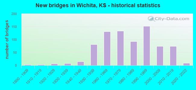
- New bridges - historical statistics
- 41900-1909
- 41910-1919
- 71920-1929
- 81930-1939
- 151940-1949
- 811950-1959
- 1311960-1969
- 1341970-1979
- 931980-1989
- 1521990-1999
- 742000-2009
- 742010-2019
- 92020-2022
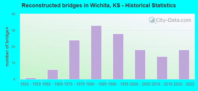
- Reconstructed bridges - Historical Statistics
- 11950-1959
- 61960-1969
- 241970-1979
- 331980-1989
- 281990-1999
- 182000-2009
- 142010-2019
- 182020-2022
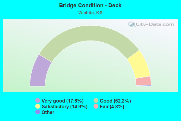
- Bridge Condition - Deck
- 17.6%Very good
- 62.2%Good
- 14.9%Satisfactory
- 4.8%Fair
- 0.5%Poor
- 0.2%Serious
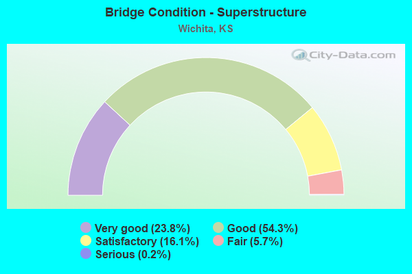
- Bridge Condition - Superstructure
- 23.8%Very good
- 54.3%Good
- 16.1%Satisfactory
- 5.7%Fair
- 0.2%Serious
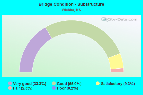
- Bridge Condition - Substructure
- 33.3%Very good
- 55.0%Good
- 9.3%Satisfactory
- 2.3%Fair
- 0.2%Poor
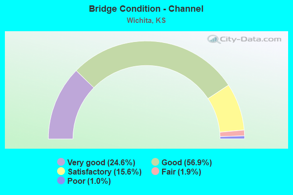
- Bridge Condition - Channel
- 24.6%Very good
- 56.9%Good
- 15.6%Satisfactory
- 1.9%Fair
- 1.0%Poor
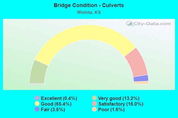
- Bridge Condition - Culverts
- 0.4%Excellent
- 13.2%Very good
- 65.4%Good
- 16.0%Satisfactory
- 3.5%Fair
- 1.6%Poor
Find on map >> Show street view
Structure Number: 43040087000033, Location: RIDGE RD .1 M S 29TH N (Lat: 37.735075, Lng: -97.426261), Route carried "on" structure: City street , Year Built: 1997, Status: Open, Structure Length: 0.88m (2.89ft), Average Daily Traffic: 18,000 (year 2006), Truck Traffic: 2%, Average Future Daily Traffic: 21,000 (year 2039), Design Load: HS 20, Features Intersected: BIG SLOUGH NORTH TRIB., Facility Carried by Structure: RIDGE ROAD
Minimum Vertical Clearance: 30.47m (99.97ft), Kilometerpoint: 0.000, Lanes on structure: 4, Owner: City or Municipal Highway Agency, Approaching Roadway Width: 14.9m (48.9ft), Material/Design: Concrete, Design/Construction: Culvert, Number Of Spans In Main Unit: 2, Length of Maximum Span: 4.3m (14.1ft)
Condition: Channel: Good, Culverts: Good, Operating Rating: 46.3 metric tons, Method Used To Determine Operating Rating: Load Factor (LF), Inventory Rating: 27.2 metric tons, Method Used To Determine Inventory Rating: Load Factor (LF), Structural Evaluation: Equal to present minimum criteria, Waterway Adequacy: Equal to present minimum criteria, Approach Roadway Alignment: Equal to present desirable criteria, Designated Inspection Frequency: Every 24 months, Inspection Date: August 2021, Wearing Surface/Protective System: Wearing Surface: Bituminous
Find on map >> Show street view
Structure Number: 430400870035S1, Location: WEST AND CALVERT (Lat: 37.633078, Lng: -97.389181), Route carried "on" structure: City street , Year Built: 1980, Status: Open, Structure Length: 0.64m (2.10ft), Average Daily Traffic: 12,500 (year 2006), Truck Traffic: 2%, Average Future Daily Traffic: 15,000 (year 2039), Design Load: HS 20, Features Intersected: BIG SLOUGH CREEK, Facility Carried by Structure: WEST STREET
Minimum Vertical Clearance: 30.47m (99.97ft), Kilometerpoint: 0.000, Lanes on structure: 4, Owner: City or Municipal Highway Agency, Approaching Roadway Width: 15.2m (49.9ft), Material/Design: Concrete, Design/Construction: Culvert, Number Of Spans In Main Unit: 2, Length of Maximum Span: 3.0m (9.8ft)
Condition: Channel: Good, Culverts: Good, Operating Rating: 32.7 metric tons, Method Used To Determine Operating Rating: Field evaluation and documented engineering judgment, Inventory Rating: 32.7 metric tons, Method Used To Determine Inventory Rating: Field evaluation and documented engineering judgment, Structural Evaluation: Better than present minimum criteria, Waterway Adequacy: Better than present minimum criteria, Approach Roadway Alignment: Equal to present desirable criteria, Designated Inspection Frequency: Every 24 months, Inspection Date: September 2021, Wearing Surface/Protective System: Wearing Surface: Low Slump Concrete
Find on map >> Show street view
Structure Number: 4304008700UBS15, Location: .25M EAST OF RIDGE ROAD (Lat: 37.746667, Lng: -97.421667), Route carried "on" structure: City street , Year Built: 2006, Status: Open, Structure Length: 0.65m (2.13ft), Average Daily Traffic: 350 (year 2006), Truck Traffic: 2%, Average Future Daily Traffic: 550 (year 2039), Design Load: HS 20, Features Intersected: TRIB TO BIG SLOUGH, Facility Carried by Structure: 34TH ST. N
Minimum Vertical Clearance: 30.47m (99.97ft), Kilometerpoint: 0.000, Lanes on structure: 2, Owner: City or Municipal Highway Agency, Approaching Roadway Width: 12.1m (39.7ft), Material/Design: Concrete, Design/Construction: Culvert, Number Of Spans In Main Unit: 2, Length of Maximum Span: 3.1m (10.2ft), Curb or Sidewalk Widths: Left: 1.4m (4.6ft), Right: 0.0m
Condition: Channel: Good, Culverts: Good, Operating Rating: 51.7 metric tons, Method Used To Determine Operating Rating: Load Factor (LF), Inventory Rating: 30.8 metric tons, Method Used To Determine Inventory Rating: Load Factor (LF), Structural Evaluation: Better than present minimum criteria, Waterway Adequacy: Equal to present desirable criteria, Approach Roadway Alignment: Equal to present desirable criteria, Designated Inspection Frequency: Every 24 months, Inspection Date: August 2021, Wearing Surface/Protective System: Wearing Surface: Bituminous
Find on map >> Show street view
Structure Number: 4304008700UBS2, Location: RIDGE AND 34TH NORTH (Lat: 37.745089, Lng: -97.426250), Route carried "on" structure: City street , Year Built: 1990, Status: Open, Structure Length: 3.35m (10.99ft), Average Daily Traffic: 9,105 (year 2006), Truck Traffic: 2%, Average Future Daily Traffic: 11,000 (year 2039), Design Load: HS 20, Features Intersected: BIG SLOUGH CREEK, Facility Carried by Structure: RIDGE ROAD
Minimum Vertical Clearance: 30.47m (99.97ft), Kilometerpoint: 0.000, Lanes on structure: 4, Owner: City or Municipal Highway Agency, Approaching Roadway Width: 19.5m (64.0ft), Skew: 3 degrees, Material/Design: Concrete continuous, Design/Construction: Slab, Number Of Spans In Main Unit: 3, Length of Maximum Span: 13.4m (44.0ft), Curb-To-Curb Width: 19.5m (64.0ft), Out-to-Out Width: 20.1m (65.9ft)
Condition: Deck: Good, Superstructure: Good, Substructure: Good, Channel: Good, Operating Rating: 60.8 metric tons, Method Used To Determine Operating Rating: Load Factor (LF), Inventory Rating: 36.4 metric tons, Method Used To Determine Inventory Rating: Load Factor (LF), Structural Evaluation: Better than present minimum criteria, Deck Geometry: Better than present minimum criteria, Waterway Adequacy: Equal to present desirable criteria, Approach Roadway Alignment: Equal to present desirable criteria, Designated Inspection Frequency: Every 24 months, Inspection Date: August 2021, Deck Structure Type: Concrete Cast-file-Place, Wearing Surface/Protective System: Wearing Surface: Monolithic Concrete
Find on map >> Show street view
Structure Number: 430400870EBGC3, Location: WATERFRONT PRK E OF WEBB (Lat: 37.715000, Lng: -97.225000), Route carried "on" structure: City street , Year Built: 2003, Status: Open, Structure Length: 1.19m (3.90ft), Average Daily Traffic: 9,000 (year 2006), Truck Traffic: 2%, Average Future Daily Traffic: 9,750 (year 2039), Design Load: HS 20, Features Intersected: EAST BR. GYPSUM CREEK, Facility Carried by Structure: WATERFONT PARKWAY
Minimum Vertical Clearance: 30.47m (99.97ft), Kilometerpoint: 0.000, Lanes on structure: 2, Owner: City or Municipal Highway Agency, Approaching Roadway Width: 11.8m (38.7ft), Skew: 1 degrees, Material/Design: Concrete, Design/Construction: Culvert, Number Of Spans In Main Unit: 3, Length of Maximum Span: 3.7m (12.1ft), Curb or Sidewalk Widths: Left: 0.0m, Right: 1.8m (5.9ft)
Condition: Channel: Good, Culverts: Good, Operating Rating: 38.1 metric tons, Method Used To Determine Operating Rating: Load Factor (LF), Inventory Rating: 32.7 metric tons, Method Used To Determine Inventory Rating: Load Factor (LF), Structural Evaluation: Better than present minimum criteria, Waterway Adequacy: Equal to present desirable criteria, Approach Roadway Alignment: Equal to present minimum criteria, Designated Inspection Frequency: Every 24 months, Inspection Date: September 2021, Wearing Surface/Protective System: Wearing Surface: Bituminous
Find on map >> Show street view
Structure Number: 4304008737062, Location: MAPLE E. OF BREEZY POINTE (Lat: 37.678889, Lng: -97.485711), Route carried "on" structure: City street 3706, Year Built: 2001, Status: Open, Structure Length: 3.96m (12.99ft), Average Daily Traffic: 10,330 (year 2006), Truck Traffic: 2%, Average Future Daily Traffic: 12,500 (year 2039), Design Load: HS 20, Features Intersected: MIDDLE FORK CALFSKIN CR., Facility Carried by Structure: MAPLE STREET
Minimum Vertical Clearance: 30.47m (99.97ft), Kilometerpoint: 0.000, Lanes on structure: 4, Owner: City or Municipal Highway Agency, Approaching Roadway Width: 16.4m (53.8ft), Material/Design: Concrete continuous, Design/Construction: Slab, Number Of Spans In Main Unit: 3, Length of Maximum Span: 16.0m (52.5ft), Curb or Sidewalk Widths: Left: 1.8m (5.9ft), Right: 1.8m (5.9ft), Curb-To-Curb Width: 16.5m (54.1ft), Out-to-Out Width: 20.6m (67.6ft)
Condition: Deck: Good, Superstructure: Good, Substructure: Good, Channel: Good, Operating Rating: 69.7 metric tons, Method Used To Determine Operating Rating: Load Factor (LF), Inventory Rating: 41.7 metric tons, Method Used To Determine Inventory Rating: Load Factor (LF), Structural Evaluation: Better than present minimum criteria, Deck Geometry: Meets minimum limits, Waterway Adequacy: Better than present minimum criteria, Approach Roadway Alignment: Equal to present desirable criteria, Length Of Structure Improvement: 3.96m (12.99ft), Designated Inspection Frequency: Every 24 months, Inspection Date: September 2021, Deck Structure Type: Concrete Cast-file-Place, Wearing Surface/Protective System: Wearing Surface: Monolithic Concrete, Deck Protection: Epoxy Coated Reinforcing
Find on map >> Show street view
Structure Number: 43040087602501, Location: MAIZE S. of hidden valley (Lat: 37.670831, Lng: -97.462219), Route carried "on" structure: City street 6025, Year Built: 1985, Status: Open, Structure Length: 4.21m (13.81ft), Average Daily Traffic: 17,400 (year 2006), Truck Traffic: 2%, Average Future Daily Traffic: 19,500 (year 2039), Design Load: HS 20, Features Intersected: CALFSKIN CREEK, Facility Carried by Structure: MAIZE ROAD
Minimum Vertical Clearance: 30.47m (99.97ft), Kilometerpoint: 0.000, Lanes on structure: 4, Owner: City or Municipal Highway Agency, Approaching Roadway Width: 15.9m (52.2ft), Skew: 3 degrees, Material/Design: Concrete continuous, Design/Construction: Slab, Number Of Spans In Main Unit: 5, Length of Maximum Span: 9.1m (29.9ft), Curb or Sidewalk Widths: Left: 1.2m (3.9ft), Right: 1.2m (3.9ft), Curb-To-Curb Width: 16.0m (52.5ft), Out-to-Out Width: 19.5m (64.0ft)
Condition: Deck: Satisfactory, Superstructure: Satisfactory, Substructure: Good, Channel: Good, Operating Rating: 69.0 metric tons, Method Used To Determine Operating Rating: Load Factor (LF), Inventory Rating: 41.3 metric tons, Method Used To Determine Inventory Rating: Load Factor (LF), Structural Evaluation: Equal to present minimum criteria, Deck Geometry: Meets minimum limits, Waterway Adequacy: Somewhat better than minimum adequacy, Approach Roadway Alignment: Equal to present desirable criteria, Length Of Structure Improvement: 4.21m (13.81ft), Designated Inspection Frequency: Every 24 months, Inspection Date: September 2021, Deck Structure Type: Concrete Cast-file-Place, Wearing Surface/Protective System: Wearing Surface: Integral Concrete, Deck Protection: Epoxy Coated Reinforcing
Find on map >> Show street view
Structure Number: 43040087602502, Location: MAIZE RD. AT 2ND. ST. (Lat: 37.685561, Lng: -97.462500), Route carried "on" structure: City street 6025, Year Built: 1940, Year Reconstructed: 1993, Status: Open, Structure Length: 7.19m (23.59ft), Average Daily Traffic: 20,500 (year 2006), Truck Traffic: 2%, Average Future Daily Traffic: 26,000 (year 2039), Design Load: HS 20, Features Intersected: COWSKIN CREEK, Facility Carried by Structure: MAIZE ROAD
Minimum Vertical Clearance: 30.47m (99.97ft), Kilometerpoint: 0.000, Lanes on structure: 4, Owner: City or Municipal Highway Agency, Approaching Roadway Width: 14.6m (47.9ft), Material/Design: Concrete continuous, Design/Construction: Slab, Number Of Spans In Main Unit: 5, Length of Maximum Span: 15.9m (52.2ft), Curb or Sidewalk Widths: Left: 1.8m (5.9ft), Right: 1.8m (5.9ft), Curb-To-Curb Width: 15.0m (49.2ft), Out-to-Out Width: 19.5m (64.0ft)
Condition: Deck: Good, Superstructure: Good, Substructure: Good, Channel: Satisfactory, Operating Rating: 67.0 metric tons, Method Used To Determine Operating Rating: Load Factor (LF), Inventory Rating: 40.1 metric tons, Method Used To Determine Inventory Rating: Load Factor (LF), Structural Evaluation: Better than present minimum criteria, Deck Geometry: High priority of replacement, Waterway Adequacy: Equal to present minimum criteria, Approach Roadway Alignment: Equal to present desirable criteria, Length Of Structure Improvement: 7.16m (23.49ft), Designated Inspection Frequency: Every 24 months, Inspection Date: September 2021, Deck Structure Type: Concrete Cast-file-Place, Wearing Surface/Protective System: Wearing Surface: Monolithic Concrete, Deck Protection: Epoxy Coated Reinforcing
Find on map >> Show street view
Structure Number: 43040087602503, Location: MAIZE .3 M N. CENTRAL (Lat: 37.698700, Lng: -97.462592), Route carried "on" structure: City street , Year Built: 1994, Status: Open, Structure Length: 0.76m (2.49ft), Average Daily Traffic: 21,000 (year 2006), Truck Traffic: 2%, Average Future Daily Traffic: 25,000 (year 2039), Design Load: HS 20, Features Intersected: COWSKIN CREEK TRIBUTARY, Facility Carried by Structure: MAIZE ROAD
Minimum Vertical Clearance: 30.47m (99.97ft), Kilometerpoint: 0.000, Lanes on structure: 4, Owner: City or Municipal Highway Agency, Approaching Roadway Width: 14.6m (47.9ft), Skew: 3 degrees, Material/Design: Concrete, Design/Construction: Culvert, Number Of Spans In Main Unit: 3, Length of Maximum Span: 2.4m (7.9ft), Curb or Sidewalk Widths: Left: 1.8m (5.9ft), Right: 1.5m (4.9ft)
Condition: Channel: Good, Culverts: Good, Inventory Rating: 78.6 metric tons, Method Used To Determine Inventory Rating: Load Factor (LF), Structural Evaluation: Better than present minimum criteria, Waterway Adequacy: Equal to present desirable criteria, Approach Roadway Alignment: Equal to present desirable criteria, Designated Inspection Frequency: Every 24 months, Inspection Date: August 2021, Wearing Surface/Protective System: Wearing Surface: Bituminous
Find on map >> Show street view
Structure Number: 43040087607501, Location: TYLER ROAD AT YOSEMITE (Lat: 37.641669, Lng: -97.445831), Route carried "on" structure: City street 6075, Year Built: 1978, Status: Open, Structure Length: 8.32m (27.30ft), Average Daily Traffic: 7,100 (year 2006), Truck Traffic: 2%, Average Future Daily Traffic: 8,000 (year 2039), Design Load: HS 20, Features Intersected: COWSKIN CREEK, Facility Carried by Structure: TYLER ROAD
Minimum Vertical Clearance: 30.47m (99.97ft), Kilometerpoint: 0.000, Lanes on structure: 2, Owner: City or Municipal Highway Agency, Approaching Roadway Width: 15.9m (52.2ft), Skew: 1 degrees, Material/Design: Concrete continuous, Design/Construction: Slab, Number Of Spans In Main Unit: 5, Length of Maximum Span: 18.3m (60.0ft), Curb or Sidewalk Widths: Left: 1.5m (4.9ft), Right: 0.0m, Curb-To-Curb Width: 16.0m (52.5ft), Out-to-Out Width: 19.4m (63.6ft)
Condition: Deck: Good, Superstructure: Good, Substructure: Good, Channel: Good, Operating Rating: 88.0 metric tons, Method Used To Determine Operating Rating: Load Factor (LF), Inventory Rating: 52.6 metric tons, Method Used To Determine Inventory Rating: Load Factor (LF), Structural Evaluation: Better than present minimum criteria, Deck Geometry: Superior to present desirable criteria, Waterway Adequacy: Better than present minimum criteria, Approach Roadway Alignment: Equal to present desirable criteria, Designated Inspection Frequency: Every 24 months, Inspection Date: September 2021, Deck Structure Type: Concrete Cast-file-Place, Wearing Surface/Protective System: Wearing Surface: Latex Concrete, Deck Protection: Epoxy Coated Reinforcing
Find on map >> Show street view
Structure Number: 43040087612501, Location: RIDGE ROAD AT US54 (Lat: 37.675556, Lng: -97.427786), Route carried "on" structure: City street 6125, Year Built: 1981, Status: Open, Structure Length: 1.01m (3.31ft), Average Daily Traffic: 24,575 (year 2006), Truck Traffic: 2%, Average Future Daily Traffic: 35,000 (year 2039), Design Load: H 20, Features Intersected: HOOVER ST. DR. DUGAN TRI, Facility Carried by Structure: MID-CONTINENT RD.
Minimum Vertical Clearance: 30.47m (99.97ft), Kilometerpoint: 0.000, Lanes on structure: 4, Owner: City or Municipal Highway Agency, Approaching Roadway Width: 17.0m (55.8ft), Skew: 23 degrees, Material/Design: Concrete, Design/Construction: Culvert, Number Of Spans In Main Unit: 3, Length of Maximum Span: 3.0m (9.8ft)
Condition: Channel: Satisfactory, Culverts: Good, Operating Rating: 89.8 metric tons, Method Used To Determine Operating Rating: Load Factor (LF), Inventory Rating: 89.8 metric tons, Method Used To Determine Inventory Rating: Load Factor (LF), Structural Evaluation: Better than present minimum criteria, Waterway Adequacy: Equal to present minimum criteria, Approach Roadway Alignment: Equal to present desirable criteria, Designated Inspection Frequency: Every 24 months, Inspection Date: September 2021, Wearing Surface/Protective System: Wearing Surface: Low Slump Concrete
Find on map >> Show street view
Structure Number: 43040087615001, Location: MAC ARTHUR E. OF SENECA (Lat: 37.622500, Lng: -97.350106), Route carried "on" structure: City street 6150, Year Built: 1984, Status: Open, Structure Length: 1.52m (4.99ft), Average Daily Traffic: 8,510 (year 2006), Truck Traffic: 2%, Average Future Daily Traffic: 10,500 (year 2039), Design Load: HS 20, Features Intersected: BIG SLOUGH SOUTH, Facility Carried by Structure: MAC ARTHUR ROAD
Minimum Vertical Clearance: 30.47m (99.97ft), Kilometerpoint: 0.000, Lanes on structure: 4, Owner: City or Municipal Highway Agency, Approaching Roadway Width: 14.9m (48.9ft), Skew: 1 degrees, Material/Design: Concrete, Design/Construction: Culvert, Number Of Spans In Main Unit: 3, Length of Maximum Span: 4.9m (16.1ft), Curb or Sidewalk Widths: Left: 1.5m (4.9ft), Right: 1.5m (4.9ft), Curb-To-Curb Width: 14.6m (47.9ft), Out-to-Out Width: 24.4m (80.1ft)
Condition: Channel: Good, Culverts: Good, Operating Rating: 57.2 metric tons, Method Used To Determine Operating Rating: Load Factor (LF), Inventory Rating: 34.2 metric tons, Method Used To Determine Inventory Rating: Load Factor (LF), Structural Evaluation: Better than present minimum criteria, Deck Geometry: High priority of replacement, Waterway Adequacy: Better than present minimum criteria, Approach Roadway Alignment: Equal to present desirable criteria, Length Of Structure Improvement: 1.83m (6.00ft), Designated Inspection Frequency: Every 24 months, Inspection Date: September 2021, Wearing Surface/Protective System: Wearing Surface: Low Slump Concrete
Find on map >> Show street view
Structure Number: 43040087625001, Location: PAWNEE AT MC LEAN BLVD. (Lat: 37.651622, Lng: -97.363392), Route carried "on" structure: City street 6250, Year Built: 1961, Year Reconstructed: 1992, Status: Open, Structure Length: 12.25m (40.19ft), Average Daily Traffic: 19,000 (year 2006), Truck Traffic: 2%, Average Future Daily Traffic: 23,500 (year 2039), Design Load: HS 20, Features Intersected: ARKANSAS RIVER, Facility Carried by Structure: PAWNEE
Minimum Vertical Clearance: 30.47m (99.97ft), Kilometerpoint: 0.000, Lanes on structure: 4, Owner: City or Municipal Highway Agency, Approaching Roadway Width: 17.0m (55.8ft), Skew: 23 degrees, Material/Design: Concrete continuous, Design/Construction: Slab, Number Of Spans In Main Unit: 9, Length of Maximum Span: 14.6m (47.9ft), Curb or Sidewalk Widths: Left: 1.5m (4.9ft), Right: 1.5m (4.9ft), Curb-To-Curb Width: 21.0m (68.9ft), Out-to-Out Width: 24.8m (81.4ft)
Condition: Deck: Good, Superstructure: Good, Substructure: Good, Channel: Good, Operating Rating: 55.3 metric tons, Method Used To Determine Operating Rating: Load Factor (LF), Inventory Rating: 32.7 metric tons, Method Used To Determine Inventory Rating: Load Factor (LF), Structural Evaluation: Better than present minimum criteria, Deck Geometry: Superior to present desirable criteria, Waterway Adequacy: Equal to present desirable criteria, Approach Roadway Alignment: Better than present minimum criteria, Designated Inspection Frequency: Every 24 months, Inspection Date: September 2021, Deck Structure Type: Concrete Cast-file-Place, Wearing Surface/Protective System: Wearing Surface: Latex Concrete
Find on map >> Show street view
Structure Number: 43040087625002, Location: PAWNEE AT I-135 (Lat: 37.650000, Lng: -97.310322), Route carried "on" structure: City street 6250, Year Built: 1966, Status: Open, Structure Length: 3.72m (12.20ft), Average Daily Traffic: 19,000 (year 2006), Truck Traffic: 2%, Average Future Daily Traffic: 25,000 (year 2039), Design Load: HS 20, Features Intersected: WICHITA DRAINAGE CANAL, Facility Carried by Structure: PAWNEE
Minimum Vertical Clearance: 4.52m (14.83ft), Kilometerpoint: 0.000, Lanes on structure: 6, Owner: City or Municipal Highway Agency, Approaching Roadway Width: 14.6m (47.9ft), Skew: 21 degrees, Material/Design: Concrete continuous, Design/Construction: Slab, Number Of Spans In Main Unit: 3, Length of Maximum Span: 14.6m (47.9ft), Curb or Sidewalk Widths: Left: 1.5m (4.9ft), Right: 1.5m (4.9ft), Curb-To-Curb Width: 22.0m (72.2ft), Out-to-Out Width: 27.1m (88.9ft)
Condition: Deck: Satisfactory, Superstructure: Satisfactory, Substructure: Satisfactory, Channel: Very good, Operating Rating: 68.0 metric tons, Method Used To Determine Operating Rating: Load Factor (LF), Inventory Rating: 39.9 metric tons, Method Used To Determine Inventory Rating: Load Factor (LF), Structural Evaluation: Equal to present minimum criteria, Deck Geometry: High priority of corrective action, Waterway Adequacy: Equal to present desirable criteria, Approach Roadway Alignment: Equal to present desirable criteria, Designated Inspection Frequency: Every 24 months, Inspection Date: September 2021, Deck Structure Type: Concrete Cast-file-Place, Wearing Surface/Protective System: Wearing Surface: Monolithic Concrete
Find on map >> Show street view
Structure Number: 43040087625003, Location: PAWNEE AT ROOSEVELT (Lat: 37.649722, Lng: -97.294683), Route carried "on" structure: City street 6250, Year Built: 1969, Status: Posted for load, Structure Length: 0.98m (3.22ft), Average Daily Traffic: 20,000 (year 2006), Truck Traffic: 2%, Average Future Daily Traffic: 22,000 (year 2039), Design Load: H 20, Features Intersected: DRY CREEK, Facility Carried by Structure: PAWNEE
Minimum Vertical Clearance: 30.47m (99.97ft), Kilometerpoint: 0.000, Lanes on structure: 4, Owner: City or Municipal Highway Agency, Approaching Roadway Width: 14.6m (47.9ft), Skew: 3 degrees, Material/Design: Concrete, Design/Construction: Culvert, Number Of Spans In Main Unit: 3, Length of Maximum Span: 3.0m (9.8ft), Curb or Sidewalk Widths: Left: 1.2m (3.9ft), Right: 1.2m (3.9ft)
Condition: Channel: Good, Culverts: Satisfactory, Operating Rating: 29.0 metric tons, Method Used To Determine Operating Rating: Load Factor (LF), Inventory Rating: 17.2 metric tons, Method Used To Determine Inventory Rating: Load Factor (LF), Structural Evaluation: Meets minimum limits, Waterway Adequacy: Better than present minimum criteria, Approach Roadway Alignment: Equal to present desirable criteria, Bridge Posting: Required (Relationship of Operating Rating to Maximum Legal Load: 10.0 - 19.9% below), Length Of Structure Improvement: 1.07m (3.51ft), Designated Inspection Frequency: Every 24 months, Inspection Date: August 2021, Bridge Improvement Cost: $100,000, Roadway Improvement Cost: $60,000, Total Project Cost: $165,000, Wearing Surface/Protective System: Wearing Surface: Bituminous
Find on map >> Show street view
Structure Number: 43040087625004, Location: PAWNEE AT KS TURNPIKE (Lat: 37.650069, Lng: -97.273733), Route carried "on" structure: City street 6250, Year Built: 1966, Status: Open, Structure Length: 4.57m (14.99ft), Average Daily Traffic: 17,000 (year 2006), Truck Traffic: 4%, Average Future Daily Traffic: 19,000 (year 2039), Design Load: HS 20, Features Intersected: GYPSUM CREEK, Facility Carried by Structure: PAWNEE
Minimum Vertical Clearance: 30.47m (99.97ft), Kilometerpoint: 0.000, Lanes on structure: 4, Owner: City or Municipal Highway Agency, Approaching Roadway Width: 15.9m (52.2ft), Skew: 3 degrees, Material/Design: Prestressed concrete continuous, Design/Construction: Tee Beam, Number Of Spans In Main Unit: 3, Length of Maximum Span: 15.9m (52.2ft), Curb or Sidewalk Widths: Left: 0.6m (2.0ft), Right: 0.6m (2.0ft), Curb-To-Curb Width: 16.0m (52.5ft), Out-to-Out Width: 17.7m (58.1ft)
Condition: Deck: Good, Superstructure: Good, Substructure: Satisfactory, Channel: Satisfactory, Operating Rating: 47.2 metric tons, Method Used To Determine Operating Rating: Load Factor (LF), Inventory Rating: 43.5 metric tons, Method Used To Determine Inventory Rating: Load Factor (LF), Structural Evaluation: Equal to present minimum criteria, Deck Geometry: Meets minimum limits, Waterway Adequacy: Better than present minimum criteria, Approach Roadway Alignment: Equal to present desirable criteria, Length Of Structure Improvement: 4.57m (14.99ft), Designated Inspection Frequency: Every 24 months, Inspection Date: September 2021, Deck Structure Type: Concrete Cast-file-Place, Wearing Surface/Protective System: Wearing Surface: Monolithic Concrete
Find on map >> Show street view
Structure Number: 43040087627501, Location: MERIDIAN AT 35TH SOUTH (Lat: 37.629619, Lng: -97.370708), Route carried "on" structure: City street 6275, Year Built: 1980, Status: Open, Structure Length: 0.91m (2.99ft), Average Daily Traffic: 11,960 (year 2006), Truck Traffic: 2%, Average Future Daily Traffic: 14,000 (year 2039), Design Load: H 20, Features Intersected: BIG SLOUGH SOUTH, Facility Carried by Structure: MERIDIAN
Minimum Vertical Clearance: 30.47m (99.97ft), Kilometerpoint: 0.000, Lanes on structure: 4, Owner: City or Municipal Highway Agency, Approaching Roadway Width: 14.6m (47.9ft), Material/Design: Concrete, Design/Construction: Culvert, Number Of Spans In Main Unit: 2, Length of Maximum Span: 4.3m (14.1ft), Curb or Sidewalk Widths: Left: 1.5m (4.9ft), Right: 1.5m (4.9ft)
Condition: Channel: Good, Culverts: Good, Operating Rating: 32.7 metric tons, Method Used To Determine Operating Rating: Field evaluation and documented engineering judgment, Inventory Rating: 32.7 metric tons, Method Used To Determine Inventory Rating: Field evaluation and documented engineering judgment, Structural Evaluation: Better than present minimum criteria, Waterway Adequacy: Better than present minimum criteria, Approach Roadway Alignment: Equal to present desirable criteria, Length Of Structure Improvement: 1.68m (5.51ft), Designated Inspection Frequency: Every 24 months, Inspection Date: September 2021, Bridge Improvement Cost: $336,000, Roadway Improvement Cost: $60,000, Total Project Cost: $400,000, Wearing Surface/Protective System: Wearing Surface: Low Slump Concrete
Find on map >> Show street view
Structure Number: 43040087627502, Location: 33RD ST S AT MERIDIAN (Lat: 37.633225, Lng: -97.370711), Route carried "on" structure: City street 6275, Year Built: 1959, Status: Open, Structure Length: 0.70m (2.30ft), Average Daily Traffic: 450 (year 2006), Truck Traffic: 1%, Average Future Daily Traffic: 500 (year 2039), Design Load: H 20, Features Intersected: MERIDIAN DITCH, Facility Carried by Structure: 33RD STREET SOUTH
Minimum Vertical Clearance: 30.47m (99.97ft), Kilometerpoint: 0.000, Lanes on structure: 2, Owner: City or Municipal Highway Agency, Approaching Roadway Width: 9.1m (29.9ft), Material/Design: Concrete, Design/Construction: Culvert, Number Of Spans In Main Unit: 3, Length of Maximum Span: 2.1m (6.9ft), Curb or Sidewalk Widths: Left: 2.9m (9.5ft), Right: 2.9m (9.5ft)
Condition: Channel: Good, Culverts: Good, Operating Rating: 39.0 metric tons, Method Used To Determine Operating Rating: Load Factor (LF), Inventory Rating: 22.7 metric tons, Method Used To Determine Inventory Rating: Load Factor (LF), Structural Evaluation: Equal to present minimum criteria, Waterway Adequacy: Equal to present minimum criteria, Approach Roadway Alignment: Better than present minimum criteria, Length Of Structure Improvement: 1.07m (3.51ft), Designated Inspection Frequency: Every 24 months, Inspection Date: September 2021, Wearing Surface/Protective System: Wearing Surface: Integral Concrete
Find on map >> Show street view
Structure Number: 43040087627503, Location: 31ST ST S AT MERIDIAN (Lat: 37.636897, Lng: -97.370781), Route carried "on" structure: City street 6275, Year Built: 1959, Status: Open, Structure Length: 0.70m (2.30ft), Average Daily Traffic: 9,800 (year 2006), Truck Traffic: 2%, Average Future Daily Traffic: 11,500 (year 2039), Design Load: H 20, Features Intersected: MERIDIAN DITCH, Facility Carried by Structure: 31ST STREET SOUTH
Minimum Vertical Clearance: 30.47m (99.97ft), Kilometerpoint: 0.000, Lanes on structure: 5, Owner: City or Municipal Highway Agency, Approaching Roadway Width: 18.2m (59.7ft), Material/Design: Concrete, Design/Construction: Culvert, Number Of Spans In Main Unit: 3, Length of Maximum Span: 2.1m (6.9ft), Curb or Sidewalk Widths: Left: 1.5m (4.9ft), Right: 1.5m (4.9ft)
Condition: Channel: Good, Culverts: Good, Operating Rating: 39.0 metric tons, Method Used To Determine Operating Rating: Load Factor (LF), Inventory Rating: 22.7 metric tons, Method Used To Determine Inventory Rating: Load Factor (LF), Structural Evaluation: Somewhat better than minimum adequacy, Waterway Adequacy: Equal to present minimum criteria, Approach Roadway Alignment: Equal to present desirable criteria, Length Of Structure Improvement: 0.76m (2.49ft), Designated Inspection Frequency: Every 24 months, Inspection Date: September 2021, Wearing Surface/Protective System: Wearing Surface: Low Slump Concrete
Find on map >> Show street view
Structure Number: 43040087627504, Location: WILDWOOD AT MERIDIAN (Lat: 37.642372, Lng: -97.370994), Route carried "on" structure: City street 6275, Year Built: 1959, Status: Open, Structure Length: 0.76m (2.49ft), Average Daily Traffic: 950 (year 2006), Truck Traffic: 2%, Average Future Daily Traffic: 1,100 (year 2039), Design Load: HS 20, Features Intersected: MERIDIAN DITCH, Facility Carried by Structure: WILDWOOD
Minimum Vertical Clearance: 30.47m (99.97ft), Kilometerpoint: 0.000, Lanes on structure: 2, Owner: City or Municipal Highway Agency, Approaching Roadway Width: 9.1m (29.9ft), Material/Design: Concrete, Design/Construction: Slab, Number Of Spans In Main Unit: 1, Length of Maximum Span: 6.1m (20.0ft), Curb or Sidewalk Widths: Left: 1.8m (5.9ft), Right: 1.8m (5.9ft), Curb-To-Curb Width: 9.0m (29.5ft), Out-to-Out Width: 13.4m (44.0ft)
Condition: Deck: Satisfactory, Superstructure: Satisfactory, Substructure: Good, Channel: Very good, Operating Rating: 49.0 metric tons, Method Used To Determine Operating Rating: Load Factor (LF), Inventory Rating: 29.0 metric tons, Method Used To Determine Inventory Rating: Load Factor (LF), Structural Evaluation: Equal to present minimum criteria, Deck Geometry: Somewhat better than minimum adequacy, Waterway Adequacy: Equal to present minimum criteria, Approach Roadway Alignment: Equal to present desirable criteria, Designated Inspection Frequency: Every 24 months, Inspection Date: September 2021, Deck Structure Type: Concrete Cast-file-Place, Wearing Surface/Protective System: Wearing Surface: Integral Concrete
Find on map >> Show street view
Structure Number: 43040087630001, Location: HARRY AT ROCK ROAD (Lat: 37.664661, Lng: -97.243642), Route carried "on" structure: City street 6300, Year Built: 1980, Status: Open, Structure Length: 0.77m (2.53ft), Average Daily Traffic: 19,500 (year 2006), Truck Traffic: 4%, Average Future Daily Traffic: 22,500 (year 2039), Design Load: H 20, Features Intersected: ROCK RD SO TRIB GYPSUM C, Facility Carried by Structure: HARRY STREET
Minimum Vertical Clearance: 30.47m (99.97ft), Kilometerpoint: 0.000, Lanes on structure: 7, Owner: City or Municipal Highway Agency, Approaching Roadway Width: 25.6m (84.0ft), Material/Design: Concrete, Design/Construction: Culvert, Number Of Spans In Main Unit: 3, Length of Maximum Span: 2.4m (7.9ft), Curb or Sidewalk Widths: Left: 1.8m (5.9ft), Right: 1.5m (4.9ft)
Condition: Channel: Satisfactory, Culverts: Satisfactory, Operating Rating: 57.2 metric tons, Method Used To Determine Operating Rating: Load Factor (LF), Inventory Rating: 33.6 metric tons, Method Used To Determine Inventory Rating: Load Factor (LF), Structural Evaluation: Equal to present minimum criteria, Waterway Adequacy: Better than present minimum criteria, Approach Roadway Alignment: Equal to present desirable criteria, Designated Inspection Frequency: Every 24 months, Inspection Date: September 2021, Wearing Surface/Protective System: Wearing Surface: Low Slump Concrete
Find on map >> Show street view
Structure Number: 43040087630AR4, Location: HARRY STREET AT McLEAN (Lat: 37.664511, Lng: -97.346092), Route carried "on" structure: City street 6300, Year Built: 2020, Status: Open, Structure Length: 10.91m (35.79ft), Average Daily Traffic: 10,900 (year 2018), Truck Traffic: 12%, Average Future Daily Traffic: 14,700 (year 2040), Design Load: HL 93, Features Intersected: ARKANSAS RIVER, Facility Carried by Structure: HARRY STREET
Minimum Vertical Clearance: 30.47m (99.97ft), Kilometerpoint: 0.000, Lanes on structure: 3, Owner: City or Municipal Highway Agency, Approaching Roadway Width: 17.8m (58.4ft), Material/Design: Prestressed concrete continuous, Design/Construction: Stringer/Multi-beam, Number Of Spans In Main Unit: 5, Length of Maximum Span: 22.9m (75.1ft), Curb or Sidewalk Widths: Left: 1.8m (5.9ft), Right: 3.7m (12.1ft), Curb-To-Curb Width: 11.3m (37.1ft), Out-to-Out Width: 17.8m (58.4ft)
Condition: Deck: Very good, Superstructure: Very good, Substructure: Very good, Channel: Very good, Operating Rating: 57.7 metric tons, Method Used To Determine Operating Rating: Load and Resistance Factor Rating (LRFR) rating reported by rating factor(RF) method using HL-93 loadings, Inventory Rating: 38.6 metric tons, Method Used To Determine Inventory Rating: Load and Resistance Factor Rating (LRFR) rating reported by rating factor(RF) method using HL-93 loadings, Structural Evaluation: Equal to present desirable criteria, Deck Geometry: High priority of replacement, Waterway Adequacy: Equal to present desirable criteria, Approach Roadway Alignment: Equal to present desirable criteria, Designated Inspection Frequency: Every 24 months, Inspection Date: October 2021, Deck Structure Type: Concrete Cast-file-Place, Wearing Surface/Protective System: Membrane: Epoxy, Deck Protection: Epoxy Coated Reinforcing
Find on map >> Show street view
Structure Number: 43040087632501, Location: SENECA AT CAREY (Lat: 37.626583, Lng: -97.352444), Route carried "on" structure: City street 6325, Year Built: 1997, Status: Open, Structure Length: 1.62m (5.31ft), Average Daily Traffic: 18,500 (year 2006), Truck Traffic: 4%, Average Future Daily Traffic: 21,000 (year 2039), Design Load: HS 20, Features Intersected: BIG SLOUGH SOUTH, Facility Carried by Structure: SENECA
Minimum Vertical Clearance: 30.47m (99.97ft), Kilometerpoint: 0.000, Lanes on structure: 4, Owner: City or Municipal Highway Agency, Approaching Roadway Width: 14.5m (47.6ft), Skew: 4 degrees, Material/Design: Concrete, Design/Construction: Culvert, Number Of Spans In Main Unit: 3, Length of Maximum Span: 3.7m (12.1ft), Curb or Sidewalk Widths: Left: 1.5m (4.9ft), Right: 1.5m (4.9ft)
Condition: Channel: Satisfactory, Culverts: Satisfactory, Operating Rating: 80.0 metric tons, Method Used To Determine Operating Rating: Load Factor (LF), Inventory Rating: 47.9 metric tons, Method Used To Determine Inventory Rating: Load Factor (LF), Structural Evaluation: Equal to present minimum criteria, Waterway Adequacy: Equal to present minimum criteria, Approach Roadway Alignment: Equal to present desirable criteria, Designated Inspection Frequency: Every 24 months, Inspection Date: September 2021, Wearing Surface/Protective System: Wearing Surface: Low Slump Concrete
Find on map >> Show street view
Structure Number: 43040087635003, Location: MAPLE AT CARLTON TWINS (Lat: 37.680119, Lng: -97.407908), Route carried "on" structure: City street 6350, Year Built: 1958, Year Reconstructed: 1990, Status: Open, Structure Length: 26.33m (86.38ft), Average Daily Traffic: 21,700 (year 2006), Truck Traffic: 2%, Average Future Daily Traffic: 26,000 (year 2039), Design Load: HS 20, Features Intersected: WICHITA VALLEY CTR FLDWY, Facility Carried by Structure: MAPLE STREET
Minimum Vertical Clearance: 30.47m (99.97ft), Kilometerpoint: 0.000, Lanes on structure: 4, Owner: City or Municipal Highway Agency, Approaching Roadway Width: 15.9m (52.2ft), Skew: 13 degrees, Material/Design: Prestressed concrete continuous, Design/Construction: Stringer/Multi-beam, Number Of Spans In Main Unit: 10, Length of Maximum Span: 26.8m (87.9ft), Curb or Sidewalk Widths: Left: 1.8m (5.9ft), Right: 1.8m (5.9ft), Curb-To-Curb Width: 16.0m (52.5ft), Out-to-Out Width: 21.4m (70.2ft)
Condition: Deck: Good, Superstructure: Very good, Substructure: Good, Channel: Good, Operating Rating: 63.0 metric tons, Method Used To Determine Operating Rating: Load Factor (LF), Inventory Rating: 37.7 metric tons, Method Used To Determine Inventory Rating: Load Factor (LF), Structural Evaluation: Better than present minimum criteria, Deck Geometry: Meets minimum limits, Waterway Adequacy: Better than present minimum criteria, Approach Roadway Alignment: Equal to present desirable criteria, Designated Inspection Frequency: Every 24 months, Inspection Date: September 2021, Deck Structure Type: Concrete Cast-file-Place, Wearing Surface/Protective System: Wearing Surface: Latex Concrete, Deck Protection: Epoxy Coated Reinforcing
Find on map >> Show street view
Structure Number: 43040087635101, Location: AMIDON AT 18TH. ST. NORTH (Lat: 37.716414, Lng: -97.363106), Route carried "on" structure: City street 6351, Year Built: 1964, Status: Open, Structure Length: 14.84m (48.69ft), Average Daily Traffic: 16,500 (year 2006), Truck Traffic: 2%, Average Future Daily Traffic: 18,000 (year 2039), Design Load: HS 20, Features Intersected: ARKANSAS RIVER, Facility Carried by Structure: AMIDON
Minimum Vertical Clearance: 30.47m (99.97ft), Kilometerpoint: 0.000, Lanes on structure: 4, Owner: City or Municipal Highway Agency, Approaching Roadway Width: 14.6m (47.9ft), Skew: 34 degrees, Material/Design: Concrete continuous, Design/Construction: Tee Beam, Number Of Spans In Main Unit: 7, Length of Maximum Span: 22.6m (74.1ft), Curb or Sidewalk Widths: Left: 1.2m (3.9ft), Right: 0.6m (2.0ft), Curb-To-Curb Width: 17.1m (56.1ft), Out-to-Out Width: 21.4m (70.2ft)
Condition: Deck: Fair, Superstructure: Satisfactory, Substructure: Fair, Channel: Good, Operating Rating: 54.4 metric tons, Method Used To Determine Operating Rating: Load Factor (LF), Inventory Rating: 32.7 metric tons, Method Used To Determine Inventory Rating: Load Factor (LF), Structural Evaluation: Somewhat better than minimum adequacy, Deck Geometry: Somewhat better than minimum adequacy, Waterway Adequacy: Equal to present desirable criteria, Approach Roadway Alignment: Equal to present desirable criteria, Length Of Structure Improvement: 14.87m (48.79ft), Designated Inspection Frequency: Every 24 months, Inspection Date: October 2021, Deck Structure Type: Concrete Cast-file-Place, Wearing Surface/Protective System: Wearing Surface: Bituminous
Find on map >> Show street view
Structure Number: 43040087635102, Location: womer S of 37th NORTH (Lat: 37.747269, Lng: -97.365678), Route carried "on" structure: City street 6351, Year Built: 1983, Status: Open, Structure Length: 12.44m (40.81ft), Average Daily Traffic: 10,000 (year 2006), Truck Traffic: 2%, Average Future Daily Traffic: 11,500 (year 2039), Design Load: HS 20, Features Intersected: WICHITA VALLEY CTR FLDWY, Facility Carried by Structure: WOMER
Minimum Vertical Clearance: 30.47m (99.97ft), Kilometerpoint: 0.000, Lanes on structure: 4, Owner: City or Municipal Highway Agency, Approaching Roadway Width: 14.6m (47.9ft), Material/Design: Prestressed concrete continuous, Design/Construction: Stringer/Multi-beam, Number Of Spans In Main Unit: 7, Length of Maximum Span: 16.8m (55.1ft), Curb or Sidewalk Widths: Left: 1.5m (4.9ft), Right: 1.5m (4.9ft), Curb-To-Curb Width: 16.0m (52.5ft), Out-to-Out Width: 20.4m (66.9ft)
Condition: Deck: Good, Superstructure: Very good, Substructure: Good, Channel: Good, Operating Rating: 42.6 metric tons, Method Used To Determine Operating Rating: Load Factor (LF), Inventory Rating: 37.2 metric tons, Method Used To Determine Inventory Rating: Load Factor (LF), Structural Evaluation: Better than present minimum criteria, Deck Geometry: Meets minimum limits, Waterway Adequacy: Equal to present desirable criteria, Approach Roadway Alignment: Equal to present desirable criteria, Length Of Structure Improvement: 12.44m (40.81ft), Designated Inspection Frequency: Every 24 months, Inspection Date: September 2021, Deck Structure Type: Concrete Cast-file-Place, Wearing Surface/Protective System: Wearing Surface: Latex Concrete
Find on map >> Show street view
Structure Number: 43040087637001, Location: DOUGLAS AT MCLEAN BLVD. (Lat: 37.685500, Lng: -97.343472), Route carried "on" structure: City street 6370, Year Built: 1999, Status: Open, Structure Length: 11.89m (39.01ft), Average Daily Traffic: 15,500 (year 2006), Truck Traffic: 2%, Average Future Daily Traffic: 24,000 (year 2039), Design Load: HS 20, Features Intersected: ARKANSAS RIVER, Facility Carried by Structure: DOUGLAS AVENUE
Minimum Vertical Clearance: 30.47m (99.97ft), Kilometerpoint: 0.000, Lanes on structure: 5, Owner: City or Municipal Highway Agency, Approaching Roadway Width: 18.2m (59.7ft), Material/Design: Steel continuous, Design/Construction: Box Beam or Girders - Multiple, Number Of Spans In Main Unit: 3, Length of Maximum Span: 39.6m (129.9ft), Curb or Sidewalk Widths: Left: 3.6m (11.8ft), Right: 3.6m (11.8ft), Curb-To-Curb Width: 18.3m (60.0ft), Out-to-Out Width: 27.4m (89.9ft)
Condition: Deck: Good, Superstructure: Good, Substructure: Good, Channel: Good, Operating Rating: 49.9 metric tons, Method Used To Determine Operating Rating: Load Factor (LF), Inventory Rating: 37.2 metric tons, Method Used To Determine Inventory Rating: Load Factor (LF), Structural Evaluation: Better than present minimum criteria, Deck Geometry: High priority of replacement, Waterway Adequacy: Better than present minimum criteria, Approach Roadway Alignment: Equal to present desirable criteria, Designated Inspection Frequency: Every 24 months, Inspection Date: August 2021, Deck Structure Type: Concrete Cast-file-Place, Wearing Surface/Protective System: Wearing Surface: Latex Concrete, Deck Protection: Epoxy Coated Reinforcing
Find on map >> Show street view
Structure Number: 43040087637501, Location: BROADWAY N. OF I-235 (Lat: 37.758661, Lng: -97.336553), Route carried "on" structure: City street 6375, Year Built: 1900, Status: Posted for load, Structure Length: 0.98m (3.22ft), Average Daily Traffic: 6,000 (year 2006), Truck Traffic: 4%, Average Future Daily Traffic: 8,500 (year 2039), Design Load: H 20, Features Intersected: CHISHOLM CREEK TRIB., Facility Carried by Structure: BROADWAY
Minimum Vertical Clearance: 30.47m (99.97ft), Kilometerpoint: 0.000, Lanes on structure: 4, Owner: City or Municipal Highway Agency, Approaching Roadway Width: 15.2m (49.9ft), Skew: 20 degrees, Material/Design: Concrete, Design/Construction: Culvert, Number Of Spans In Main Unit: 3, Length of Maximum Span: 3.0m (9.8ft), Curb-To-Curb Width: 25.3m (83.0ft), Out-to-Out Width: 25.9m (85.0ft)
Condition: Channel: Good, Culverts: Satisfactory, Operating Rating: 28.1 metric tons, Method Used To Determine Operating Rating: Load Factor (LF), Inventory Rating: 16.3 metric tons, Method Used To Determine Inventory Rating: Load Factor (LF), Structural Evaluation: Meets minimum limits, Deck Geometry: Superior to present desirable criteria, Waterway Adequacy: Better than present minimum criteria, Approach Roadway Alignment: Equal to present desirable criteria, Bridge Posting: Required (Relationship of Operating Rating to Maximum Legal Load: 10.0 - 19.9% below), Length Of Structure Improvement: 1.52m (4.99ft), Designated Inspection Frequency: Every 24 months, Inspection Date: September 2021, Bridge Improvement Cost: $100,000, Roadway Improvement Cost: $10,000, Total Project Cost: $110,000, Wearing Surface/Protective System: Wearing Surface: Bituminous
Find on map >> Show street view
Structure Number: 430400876400005, Location: CENTRAL AT KARREN (Lat: 37.693333, Lng: -97.466667), Route carried "on" structure: City street 6400, Year Built: 1989, Status: Open, Structure Length: 6.80m (22.31ft), Average Daily Traffic: 8,500 (year 2006), Truck Traffic: 2%, Average Future Daily Traffic: 10,000 (year 2039), Design Load: H 20, Features Intersected: COWSKIN CREEK, Facility Carried by Structure: CENTRAL
Minimum Vertical Clearance: 30.47m (99.97ft), Kilometerpoint: 0.000, Lanes on structure: 4, Owner: City or Municipal Highway Agency, Approaching Roadway Width: 14.5m (47.6ft), Material/Design: Prestressed concrete continuous, Design/Construction: Tee Beam, Number Of Spans In Main Unit: 4, Length of Maximum Span: 18.6m (61.0ft), Curb or Sidewalk Widths: Left: 1.5m (4.9ft), Right: 1.5m (4.9ft), Curb-To-Curb Width: 16.0m (52.5ft), Out-to-Out Width: 19.6m (64.3ft)
Condition: Deck: Satisfactory, Superstructure: Satisfactory, Substructure: Good, Channel: Good, Operating Rating: 38.1 metric tons, Method Used To Determine Operating Rating: Load Factor (LF), Inventory Rating: 33.6 metric tons, Method Used To Determine Inventory Rating: Load Factor (LF), Structural Evaluation: Equal to present minimum criteria, Deck Geometry: Meets minimum limits, Waterway Adequacy: Equal to present minimum criteria, Approach Roadway Alignment: Equal to present desirable criteria, Designated Inspection Frequency: Every 24 months, Inspection Date: August 2021, Deck Structure Type: Concrete Cast-file-Place, Wearing Surface/Protective System: Wearing Surface: Latex Concrete
Find on map >> Show street view
Structure Number: 43040087640001, Location: CENTRAL AT WESTLINK (Lat: 37.693889, Lng: -97.449439), Route carried "on" structure: City street 6400, Year Built: 1969, Status: Open, Structure Length: 1.31m (4.30ft), Average Daily Traffic: 22,560 (year 2006), Truck Traffic: 2%, Average Future Daily Traffic: 30,500 (year 2039), Design Load: H 20, Features Intersected: WESTLINK TRIB COWSKIN CR, Facility Carried by Structure: CENTRAL
Minimum Vertical Clearance: 30.47m (99.97ft), Kilometerpoint: 0.000, Lanes on structure: 5, Owner: City or Municipal Highway Agency, Approaching Roadway Width: 18.8m (61.7ft), Material/Design: Concrete, Design/Construction: Culvert, Number Of Spans In Main Unit: 4, Length of Maximum Span: 3.0m (9.8ft), Curb or Sidewalk Widths: Left: 1.2m (3.9ft), Right: 1.2m (3.9ft)
Condition: Channel: Good, Culverts: Good, Operating Rating: 45.4 metric tons, Method Used To Determine Operating Rating: Load Factor (LF), Inventory Rating: 26.3 metric tons, Method Used To Determine Inventory Rating: Load Factor (LF), Structural Evaluation: Equal to present minimum criteria, Waterway Adequacy: Equal to present desirable criteria, Approach Roadway Alignment: Equal to present desirable criteria, Length Of Structure Improvement: 1.31m (4.30ft), Designated Inspection Frequency: Every 24 months, Inspection Date: August 2021, Wearing Surface/Protective System: Wearing Surface: Bituminous
Find on map >> Show street view
Structure Number: 43040087640002, Location: CENTRAL @ WINTERSET(WB) (Lat: 37.694583, Lng: -97.419222), Route carried "on" structure: City street 6400, Year Built: 1977, Status: Open, Structure Length: 4.66m (15.29ft), Average Daily Traffic: 15,400 (year 2006), Truck Traffic: 2%, Average Future Daily Traffic: 20,000 (year 2039), Design Load: HS 20, Features Intersected: BIG SLOUGH NORTH, Facility Carried by Structure: CENTRAL
Minimum Vertical Clearance: 30.47m (99.97ft), Kilometerpoint: 0.000, Lanes on structure: 2, Owner: City or Municipal Highway Agency, Approaching Roadway Width: 18.2m (59.7ft), Skew: 20 degrees, Material/Design: Concrete continuous, Design/Construction: Slab, Number Of Spans In Main Unit: 4, Length of Maximum Span: 13.1m (43.0ft), Curb or Sidewalk Widths: Left: 1.8m (5.9ft), Right: 2.6m (8.5ft), Curb-To-Curb Width: 8.0m (26.2ft), Out-to-Out Width: 13.2m (43.3ft)
Condition: Deck: Good, Superstructure: Good, Substructure: Good, Channel: Good, Operating Rating: 54.7 metric tons, Method Used To Determine Operating Rating: Load Factor (LF), Inventory Rating: 32.7 metric tons, Method Used To Determine Inventory Rating: Load Factor (LF), Structural Evaluation: Better than present minimum criteria, Deck Geometry: High priority of replacement, Waterway Adequacy: Equal to present desirable criteria, Approach Roadway Alignment: Equal to present desirable criteria, Length Of Structure Improvement: 4.66m (15.29ft), Designated Inspection Frequency: Every 24 months, Inspection Date: September 2021, Deck Structure Type: Concrete Cast-file-Place, Wearing Surface/Protective System: Wearing Surface: Latex Concrete
Find on map >> Show street view
Structure Number: 430400876400025, Location: CENTRAL @ WINTERSET(EB) (Lat: 37.694444, Lng: -97.419222), Route carried "on" structure: City street 6400, Year Built: 1977, Status: Open, Structure Length: 4.66m (15.29ft), Average Daily Traffic: 15,400 (year 2006), Truck Traffic: 2%, Average Future Daily Traffic: 20,000 (year 2039), Design Load: HS 20, Features Intersected: BIG SLOUGH NORTH, Facility Carried by Structure: CENTRAL
Minimum Vertical Clearance: 30.47m (99.97ft), Kilometerpoint: 0.000, Lanes on structure: 2, Owner: City or Municipal Highway Agency, Approaching Roadway Width: 18.2m (59.7ft), Skew: 20 degrees, Material/Design: Concrete continuous, Design/Construction: Slab, Number Of Spans In Main Unit: 4, Length of Maximum Span: 13.1m (43.0ft), Curb or Sidewalk Widths: Left: 2.6m (8.5ft), Right: 1.8m (5.9ft), Curb-To-Curb Width: 8.0m (26.2ft), Out-to-Out Width: 13.5m (44.3ft)
Condition: Deck: Good, Superstructure: Good, Substructure: Good, Channel: Good, Operating Rating: 54.7 metric tons, Method Used To Determine Operating Rating: Load Factor (LF), Inventory Rating: 32.7 metric tons, Method Used To Determine Inventory Rating: Load Factor (LF), Structural Evaluation: Better than present minimum criteria, Deck Geometry: High priority of replacement, Waterway Adequacy: Equal to present desirable criteria, Approach Roadway Alignment: Equal to present desirable criteria, Designated Inspection Frequency: Every 24 months, Inspection Date: September 2021, Deck Structure Type: Concrete Cast-file-Place, Wearing Surface/Protective System: Wearing Surface: Latex Concrete
Find on map >> Show street view
Structure Number: 43040087640003, Location: CENTRAL AT WVCF(WB) (Lat: 37.694572, Lng: -97.416669), Route carried "on" structure: City street 6400, Year Built: 1977, Status: Open, Structure Length: 16.34m (53.61ft), Average Daily Traffic: 15,400 (year 2006), Truck Traffic: 2%, Average Future Daily Traffic: 20,000 (year 2039), Design Load: HS 20, Features Intersected: WICHITA VALLEY CTR FLDWY, Facility Carried by Structure: CENTRAL
Minimum Vertical Clearance: 30.47m (99.97ft), Kilometerpoint: 0.000, Lanes on structure: 2, Owner: City or Municipal Highway Agency, Approaching Roadway Width: 15.9m (52.2ft), Skew: 10 degrees, Material/Design: Concrete continuous, Design/Construction: Slab, Number Of Spans In Main Unit: 10, Length of Maximum Span: 17.1m (56.1ft), Curb or Sidewalk Widths: Left: 1.8m (5.9ft), Right: 0.0m, Curb-To-Curb Width: 8.0m (26.2ft), Out-to-Out Width: 10.1m (33.1ft)
Condition: Deck: Satisfactory, Superstructure: Satisfactory, Substructure: Satisfactory, Channel: Good, Operating Rating: 46.6 metric tons, Method Used To Determine Operating Rating: Load Factor (LF), Inventory Rating: 28.0 metric tons, Method Used To Determine Inventory Rating: Load Factor (LF), Structural Evaluation: Equal to present minimum criteria, Deck Geometry: High priority of replacement, Waterway Adequacy: Better than present minimum criteria, Approach Roadway Alignment: Equal to present desirable criteria, Length Of Structure Improvement: 16.34m (53.61ft), Designated Inspection Frequency: Every 24 months, Inspection Date: September 2021, Deck Structure Type: Concrete Cast-file-Place, Wearing Surface/Protective System: Wearing Surface: Latex Concrete
Find on map >> Show street view
Structure Number: 430400876400035, Location: CENTRAL AT WVCF(EB) (Lat: 37.694439, Lng: -97.416622), Route carried "on" structure: City street 6400, Year Built: 1977, Status: Open, Structure Length: 16.34m (53.61ft), Average Daily Traffic: 15,400 (year 2006), Truck Traffic: 2%, Average Future Daily Traffic: 20,000 (year 2039), Design Load: HS 20, Features Intersected: WICHITA VALLEY CTR FLDWY, Facility Carried by Structure: CENTRAL
Minimum Vertical Clearance: 30.47m (99.97ft), Kilometerpoint: 0.000, Lanes on structure: 2, Owner: City or Municipal Highway Agency, Approaching Roadway Width: 15.8m (51.8ft), Skew: 10 degrees, Material/Design: Concrete continuous, Design/Construction: Slab, Number Of Spans In Main Unit: 10, Length of Maximum Span: 17.1m (56.1ft), Curb or Sidewalk Widths: Left: 0.0m, Right: 1.8m (5.9ft), Curb-To-Curb Width: 8.0m (26.2ft), Out-to-Out Width: 10.1m (33.1ft)
Condition: Deck: Satisfactory, Superstructure: Satisfactory, Substructure: Good, Channel: Good, Operating Rating: 46.6 metric tons, Method Used To Determine Operating Rating: Load Factor (LF), Inventory Rating: 28.0 metric tons, Method Used To Determine Inventory Rating: Load Factor (LF), Structural Evaluation: Equal to present minimum criteria, Deck Geometry: High priority of replacement, Waterway Adequacy: Better than present minimum criteria, Approach Roadway Alignment: Equal to present desirable criteria, Designated Inspection Frequency: Every 24 months, Inspection Date: September 2021, Deck Structure Type: Concrete Cast-file-Place, Wearing Surface/Protective System: Wearing Surface: Latex Concrete
Find on map >> Show street view
Structure Number: 43040087640004, Location: SENECA AT MC LEAN BLVD (Lat: 37.691456, Lng: -97.353178), Route carried "on" structure: City street 6400, Year Built: 1925, Year Reconstructed: 1989, Status: Open, Structure Length: 9.91m (32.51ft), Average Daily Traffic: 18,730 (year 2006), Truck Traffic: 2%, Average Future Daily Traffic: 19,500 (year 2039), Design Load: HS 20, Features Intersected: ARKANSAS RIVER, Facility Carried by Structure: SENECA
Minimum Vertical Clearance: 30.47m (99.97ft), Kilometerpoint: 0.000, Lanes on structure: 5, Owner: City or Municipal Highway Agency, Approaching Roadway Width: 17.0m (55.8ft), Material/Design: Prestressed concrete continuous, Design/Construction: Tee Beam, Number Of Spans In Main Unit: 8, Length of Maximum Span: 15.5m (50.9ft), Curb or Sidewalk Widths: Left: 1.8m (5.9ft), Right: 1.8m (5.9ft), Curb-To-Curb Width: 20.0m (65.6ft), Out-to-Out Width: 23.2m (76.1ft)
Condition: Deck: Satisfactory, Superstructure: Satisfactory, Substructure: Fair, Channel: Good, Operating Rating: 37.2 metric tons, Method Used To Determine Operating Rating: Load Factor (LF), Inventory Rating: 31.8 metric tons, Method Used To Determine Inventory Rating: Load Factor (LF), Structural Evaluation: Somewhat better than minimum adequacy, Deck Geometry: Somewhat better than minimum adequacy, Waterway Adequacy: Equal to present desirable criteria, Approach Roadway Alignment: Equal to present desirable criteria, Designated Inspection Frequency: Every 24 months, Inspection Date: October 2021, Deck Structure Type: Concrete Cast-file-Place, Wearing Surface/Protective System: Wearing Surface: Latex Concrete, Deck Protection: Epoxy Coated Reinforcing
Find on map >> Show street view
Structure Number: 43040087640005, Location: CENTRAL AT SENECA (Lat: 37.693339, Lng: -97.351389), Route carried "on" structure: City street 6400, Year Built: 1931, Year Reconstructed: 1986, Status: Open, Structure Length: 9.72m (31.89ft), Average Daily Traffic: 18,730 (year 2006), Truck Traffic: 2%, Average Future Daily Traffic: 19,500 (year 2039), Design Load: HS 20, Features Intersected: LITTLE ARKANSAS RIVER, Facility Carried by Structure: CENTRAL
Minimum Vertical Clearance: 30.47m (99.97ft), Kilometerpoint: 0.000, Lanes on structure: 4, Owner: City or Municipal Highway Agency, Approaching Roadway Width: 15.9m (52.2ft), Skew: 4 degrees, Material/Design: Prestressed concrete continuous, Design/Construction: Stringer/Multi-beam, Number Of Spans In Main Unit: 3, Length of Maximum Span: 33.2m (108.9ft), Curb or Sidewalk Widths: Left: 2.4m (7.9ft), Right: 2.4m (7.9ft), Curb-To-Curb Width: 16.0m (52.5ft), Out-to-Out Width: 21.7m (71.2ft)
Condition: Deck: Good, Superstructure: Good, Substructure: Good, Channel: Very good, Operating Rating: 56.5 metric tons, Method Used To Determine Operating Rating: Load Factor (LF), Inventory Rating: 31.6 metric tons, Method Used To Determine Inventory Rating: Load Factor (LF), Structural Evaluation: Better than present minimum criteria, Deck Geometry: Meets minimum limits, Waterway Adequacy: Equal to present desirable criteria, Approach Roadway Alignment: Better than present minimum criteria, Length Of Structure Improvement: 9.72m (31.89ft), Designated Inspection Frequency: Every 24 months, Underwater Inspection Frequency: Every 60 months, Inspection Date: October 2021, Underwater Inspection Date: December 2018, Deck Structure Type: Concrete Cast-file-Place, Wearing Surface/Protective System: Wearing Surface: Latex Concrete, Deck Protection: Epoxy Coated Reinforcing
Find on map >> Show street view
Structure Number: 430400876400059, Location: CENTRAL AT I-135 (Lat: 37.693628, Lng: -97.315450), Route carried "on" structure: City street , Year Built: 1971, Status: Open, Structure Length: 3.75m (12.30ft), Average Daily Traffic: 9,000 (year 2006), Truck Traffic: 2%, Average Future Daily Traffic: 9,750 (year 2039), Design Load: HS 20, Features Intersected: WICHITA DRAINAGE CANAL, Facility Carried by Structure: CENTRAL(WB)
Minimum Vertical Clearance: 4.72m (15.49ft), Kilometerpoint: 0.000, Lanes on structure: 2, Owner: City or Municipal Highway Agency, Approaching Roadway Width: 8.2m (26.9ft), Skew: 21 degrees, Material/Design: Concrete continuous, Design/Construction: Slab, Number Of Spans In Main Unit: 3, Length of Maximum Span: 14.6m (47.9ft), Curb or Sidewalk Widths: Left: 1.8m (5.9ft), Right: 2.7m (8.9ft), Curb-To-Curb Width: 8.4m (27.6ft), Out-to-Out Width: 13.5m (44.3ft)
Condition: Deck: Good, Superstructure: Good, Substructure: Good, Channel: Very good, Operating Rating: 39.2 metric tons, Method Used To Determine Operating Rating: Load Factor (LF), Inventory Rating: 23.4 metric tons, Method Used To Determine Inventory Rating: Load Factor (LF), Structural Evaluation: Somewhat better than minimum adequacy, Deck Geometry: High priority of corrective action, Waterway Adequacy: Equal to present desirable criteria, Approach Roadway Alignment: Equal to present desirable criteria, Designated Inspection Frequency: Every 24 months, Inspection Date: November 2021, Deck Structure Type: Concrete Cast-file-Place, Wearing Surface/Protective System: Wearing Surface: Integral Concrete
Find on map >> Show street view
Structure Number: 43040087640006, Location: CENTRAL AT I-135 (Lat: 37.693453, Lng: -97.315383), Route carried "on" structure: City street 6400, Year Built: 1971, Status: Open, Structure Length: 3.75m (12.30ft), Average Daily Traffic: 9,000 (year 2006), Truck Traffic: 2%, Average Future Daily Traffic: 9,750 (year 2039), Design Load: HS 20, Features Intersected: WICHITA DRAINAGE CANAL, Facility Carried by Structure: CENTRAL (EB)
Minimum Vertical Clearance: 4.72m (15.49ft), Kilometerpoint: 0.000, Lanes on structure: 4, Owner: City or Municipal Highway Agency, Approaching Roadway Width: 10.9m (35.8ft), Skew: 21 degrees, Material/Design: Concrete continuous, Design/Construction: Slab, Number Of Spans In Main Unit: 3, Length of Maximum Span: 14.6m (47.9ft), Curb or Sidewalk Widths: Left: 0.0m, Right: 1.8m (5.9ft), Curb-To-Curb Width: 15.6m (51.2ft), Out-to-Out Width: 20.8m (68.2ft)
Condition: Deck: Good, Superstructure: Good, Substructure: Good, Channel: Very good, Operating Rating: 45.5 metric tons, Method Used To Determine Operating Rating: Load Factor (LF), Inventory Rating: 27.2 metric tons, Method Used To Determine Inventory Rating: Load Factor (LF), Structural Evaluation: Equal to present minimum criteria, Deck Geometry: Meets minimum limits, Waterway Adequacy: Equal to present desirable criteria, Approach Roadway Alignment: Equal to present desirable criteria, Designated Inspection Frequency: Every 24 months, Inspection Date: November 2021, Deck Structure Type: Concrete Cast-file-Place, Wearing Surface/Protective System: Wearing Surface: Latex Concrete
Find on map >> Show street view
Structure Number: 43040087640007, Location: CENTRAL AT RUTAN (Lat: 37.693636, Lng: -97.297797), Route carried "on" structure: City street 6400, Year Built: 1961, Status: Open, Structure Length: 0.79m (2.59ft), Average Daily Traffic: 18,500 (year 2009), Truck Traffic: 2%, Average Future Daily Traffic: 14,045 (year 2039), Design Load: H 20, Features Intersected: THIRD STREET DRAIN, Facility Carried by Structure: CENTRAL
Minimum Vertical Clearance: 30.47m (99.97ft), Kilometerpoint: 0.000, Lanes on structure: 6, Owner: City or Municipal Highway Agency, Approaching Roadway Width: 24.3m (79.7ft), Skew: 20 degrees, Material/Design: Concrete, Design/Construction: Culvert, Number Of Spans In Main Unit: 3, Length of Maximum Span: 2.4m (7.9ft), Curb or Sidewalk Widths: Left: 1.5m (4.9ft), Right: 1.5m (4.9ft)
Condition: Culverts: Good, Operating Rating: 22.3 metric tons, Method Used To Determine Operating Rating: Load Factor (LF), Inventory Rating: 20.7 metric tons, Method Used To Determine Inventory Rating: Load Factor (LF), Structural Evaluation: Somewhat better than minimum adequacy, Waterway Adequacy: Better than present minimum criteria, Approach Roadway Alignment: Equal to present desirable criteria, Length Of Structure Improvement: 0.76m (2.49ft), Designated Inspection Frequency: Every 24 months, Inspection Date: November 2021, Bridge Improvement Cost: $60,000, Roadway Improvement Cost: $60,000, Total Project Cost: $130,000, Wearing Surface/Protective System: Wearing Surface: Low Slump Concrete
Find on map >> Show street view
Structure Number: 43040087640008, Location: CENTRAL AT BLECKLEY (Lat: 37.693772, Lng: -97.278825), Route carried "on" structure: City street 6400, Year Built: 1942, Year Reconstructed: 2002, Status: Open, Structure Length: 0.98m (3.22ft), Average Daily Traffic: 20,000 (year 2006), Truck Traffic: 2%, Average Future Daily Traffic: 23,500 (year 2039), Design Load: H 20, Features Intersected: WEST BRANCH DRY CREEK, Facility Carried by Structure: CENTRAL
Minimum Vertical Clearance: 30.47m (99.97ft), Kilometerpoint: 0.000, Lanes on structure: 5, Owner: City or Municipal Highway Agency, Approaching Roadway Width: 18.2m (59.7ft), Material/Design: Concrete, Design/Construction: Culvert, Number Of Spans In Main Unit: 3, Length of Maximum Span: 3.0m (9.8ft), Curb or Sidewalk Widths: Left: 2.7m (8.9ft), Right: 2.7m (8.9ft)
Condition: Channel: Good, Culverts: Good, Operating Rating: 72.6 metric tons, Method Used To Determine Operating Rating: Load Factor (LF), Inventory Rating: 36.3 metric tons, Method Used To Determine Inventory Rating: Load Factor (LF), Structural Evaluation: Better than present minimum criteria, Waterway Adequacy: Equal to present desirable criteria, Approach Roadway Alignment: Equal to present desirable criteria, Designated Inspection Frequency: Every 24 months, Inspection Date: October 2021, Wearing Surface/Protective System: Wearing Surface: Low Slump Concrete