Bridge Statistics for Wichita, Kansas (KS)
Condition, Traffic, Stress, Structural Evaluation, Project Costs
- National Bridge Inventory (NBI) Statistics
- 786Number of bridges
- 16,591ft / 5,057mTotal length
- $13,844,000Total costs
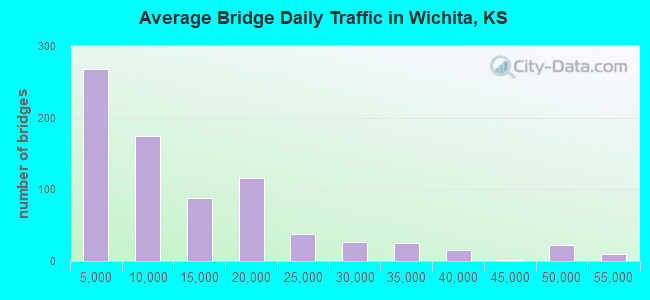
- 9,470,559Total average daily traffic
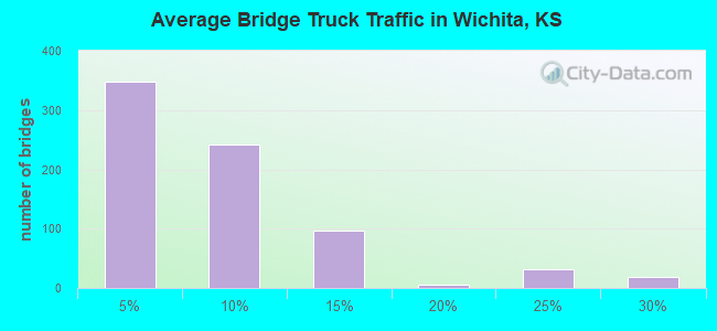
- 625,083Total average daily truck traffic
- National Bridge Inventory (NBI) Registered Bridges for Wichita
- No street view available for this location
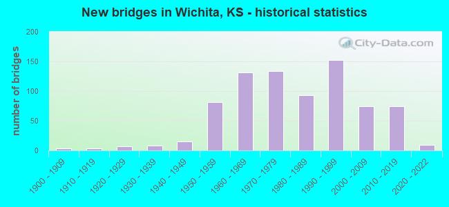
- New bridges - historical statistics
- 41900-1909
- 41910-1919
- 71920-1929
- 81930-1939
- 151940-1949
- 811950-1959
- 1311960-1969
- 1341970-1979
- 931980-1989
- 1521990-1999
- 742000-2009
- 742010-2019
- 92020-2022
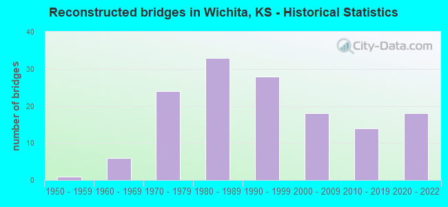
- Reconstructed bridges - Historical Statistics
- 11950-1959
- 61960-1969
- 241970-1979
- 331980-1989
- 281990-1999
- 182000-2009
- 142010-2019
- 182020-2022
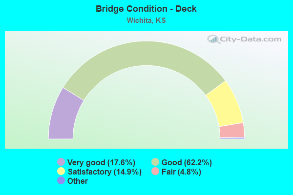
- Bridge Condition - Deck
- 17.6%Very good
- 62.2%Good
- 14.9%Satisfactory
- 4.8%Fair
- 0.5%Poor
- 0.2%Serious
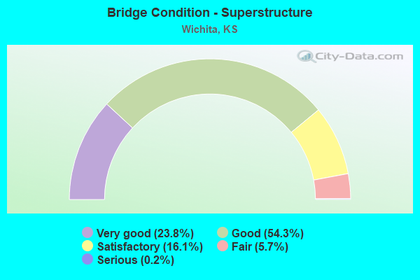
- Bridge Condition - Superstructure
- 23.8%Very good
- 54.3%Good
- 16.1%Satisfactory
- 5.7%Fair
- 0.2%Serious
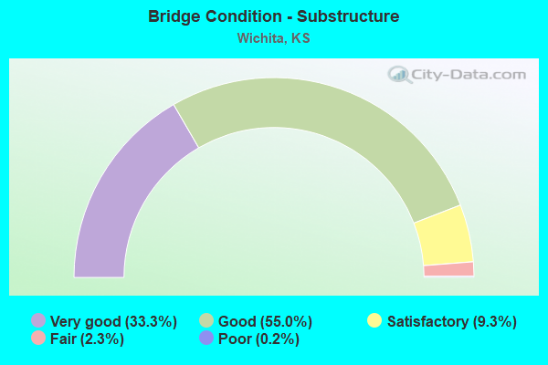
- Bridge Condition - Substructure
- 33.3%Very good
- 55.0%Good
- 9.3%Satisfactory
- 2.3%Fair
- 0.2%Poor
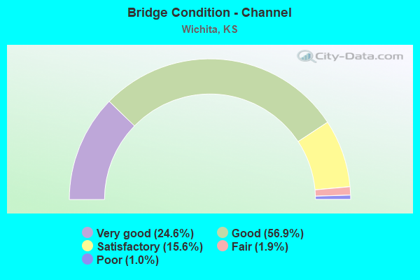
- Bridge Condition - Channel
- 24.6%Very good
- 56.9%Good
- 15.6%Satisfactory
- 1.9%Fair
- 1.0%Poor
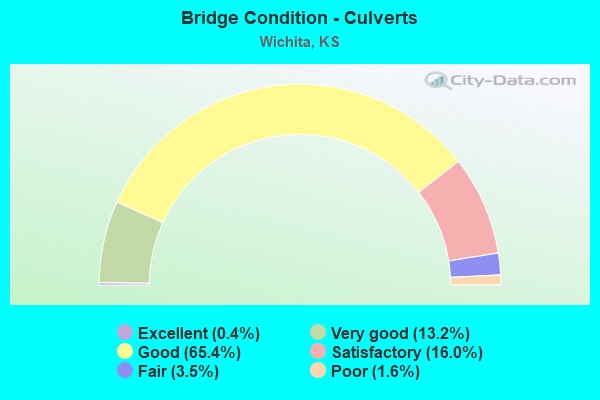
- Bridge Condition - Culverts
- 0.4%Excellent
- 13.2%Very good
- 65.4%Good
- 16.0%Satisfactory
- 3.5%Fair
- 1.6%Poor
Find on map >> Show street view
Structure Number: 999925400870331, Location: JCT I235/I135, EB (Lat: 37.761111, Lng: -97.320556), Route carried "on" structure: State highway 254, Year Built: 1964, Status: Open, Structure Length: 4.30m (14.11ft), Average Daily Traffic: 8,732 (year 2020), Truck Traffic: 8%, Average Future Daily Traffic: 12,233 (year 2041), Design Load: HS 20, Features Intersected: I135 HWY NB
Minimum Vertical Clearance: 30.47m (99.97ft), Kilometerpoint: 0.232, Lanes on structure: 1, Lanes under structure: 2, Base Highway Network: Yes, Owner: State Highway Agency, Approaching Roadway Width: 9.1m (29.9ft), Skew: 2 degrees, Material/Design: Concrete continuous, Design/Construction: Slab, Number Of Spans In Main Unit: 3, Length of Maximum Span: 17.7m (58.1ft), Curb-To-Curb Width: 9.1m (29.9ft), Out-to-Out Width: 9.7m (31.8ft)
Condition: Deck: Satisfactory, Superstructure: Fair, Substructure: Good, Operating Rating: 46.3 metric tons, Method Used To Determine Operating Rating: Load Factor (LF), Inventory Rating: 27.2 metric tons, Method Used To Determine Inventory Rating: Load Factor (LF), Structural Evaluation: Somewhat better than minimum adequacy, Deck Geometry: High priority of corrective action, Underclear: Meets minimum limits, Approach Roadway Alignment: Better than present minimum criteria, Length Of Structure Improvement: 14.11m (46.29ft), Designated Inspection Frequency: Every 24 months, Inspection Date: September 2020, Deck Structure Type: Concrete Cast-file-Place, Wearing Surface/Protective System: Wearing Surface: Bituminous
Find on map >> Show street view
Structure Number: 999925400870351, Location: 0.09 MI N I235, WB (Lat: 37.762500, Lng: -97.320833), Route carried "on" structure: State highway 96, Year Built: 1964, Status: Open, Structure Length: 7.28m (23.88ft), Average Daily Traffic: 8,732 (year 2020), Truck Traffic: 8%, Average Future Daily Traffic: 12,233 (year 2041), Design Load: HS 20, Features Intersected: 135NB,RAMP A,RAMP E E, Facility Carried by Structure: K 254 HWY WB
Minimum Vertical Clearance: 5.02m (16.47ft), Kilometerpoint: 39.313, Lanes on structure: 2, Lanes under structure: 4, Base Highway Network: Yes, Owner: State Highway Agency, Approaching Roadway Width: 12.8m (42.0ft), Skew: 2 degrees, Material/Design: Concrete continuous, Design/Construction: Slab, Number Of Spans In Main Unit: 5, Length of Maximum Span: 17.1m (56.1ft), Curb-To-Curb Width: 12.8m (42.0ft), Out-to-Out Width: 13.3m (43.6ft)
Condition: Deck: Satisfactory, Superstructure: Satisfactory, Substructure: Good, Operating Rating: 48.1 metric tons, Method Used To Determine Operating Rating: Load Factor (LF), Inventory Rating: 29.0 metric tons, Method Used To Determine Inventory Rating: Load Factor (LF), Structural Evaluation: Equal to present minimum criteria, Deck Geometry: Equal to present desirable criteria, Underclear: High priority of corrective action, Approach Roadway Alignment: Better than present minimum criteria, Length Of Structure Improvement: 23.87m (78.31ft), Designated Inspection Frequency: Every 24 months, Inspection Date: September 2020, Deck Structure Type: Concrete Cast-file-Place, Wearing Surface/Protective System: Wearing Surface: Bituminous
Find on map >> Show street view
Structure Number: 999925400871941, Location: JCT HYDRAULIC AVE/254 WB (Lat: 37.764167, Lng: -97.317222), Route carried "on" structure: State highway 254, Year Built: 1965, Year Reconstructed: 1987, Status: Open, Structure Length: 7.89m (25.89ft), Average Daily Traffic: 8,732 (year 2020), Truck Traffic: 8%, Average Future Daily Traffic: 12,233 (year 2041), Design Load: HS 20, Features Intersected: HYDRAULIC AVE-SIDE RD DR
Minimum Vertical Clearance: 30.47m (99.97ft), Kilometerpoint: 0.896, Lanes on structure: 3, Lanes under structure: 2, Base Highway Network: Yes, Owner: State Highway Agency, Approaching Roadway Width: 12.2m (40.0ft), Skew: 3 degrees, Material/Design: Concrete continuous, Design/Construction: Slab, Number Of Spans In Main Unit: 6, Length of Maximum Span: 16.8m (55.1ft), Curb-To-Curb Width: 15.2m (49.9ft), Out-to-Out Width: 16.0m (52.5ft)
Condition: Deck: Good, Superstructure: Good, Substructure: Good, Channel: Very good, Operating Rating: 50.8 metric tons, Method Used To Determine Operating Rating: Load Factor (LF), Inventory Rating: 29.9 metric tons, Method Used To Determine Inventory Rating: Load Factor (LF), Structural Evaluation: Better than present minimum criteria, Deck Geometry: Meets minimum limits, Underclear: Somewhat better than minimum adequacy, Waterway Adequacy: Equal to present desirable criteria, Approach Roadway Alignment: Better than present minimum criteria, Length Of Structure Improvement: 25.89m (84.94ft), Designated Inspection Frequency: Every 24 months, Inspection Date: September 2020, Deck Structure Type: Concrete Cast-file-Place, Wearing Surface/Protective System: Wearing Surface: Low Slump Concrete
Find on map >> Show street view
Structure Number: 999925400871951, Location: JCT HYDRAULIC AVE/254 EB (Lat: 37.763611, Lng: -97.317222), Route carried "on" structure: State highway 254, Year Built: 1965, Year Reconstructed: 1987, Status: Open, Structure Length: 9.59m (31.46ft), Average Daily Traffic: 8,732 (year 2020), Truck Traffic: 8%, Average Future Daily Traffic: 12,233 (year 2041), Design Load: HS 20, Features Intersected: HYDRAULIC AVE-SIDE RD DR
Minimum Vertical Clearance: 30.47m (99.97ft), Kilometerpoint: 0.594, Lanes on structure: 3, Lanes under structure: 2, Base Highway Network: Yes, Owner: State Highway Agency, Approaching Roadway Width: 12.2m (40.0ft), Skew: 4 degrees, Material/Design: Concrete continuous, Design/Construction: Slab, Number Of Spans In Main Unit: 6, Length of Maximum Span: 20.1m (65.9ft), Curb-To-Curb Width: 15.8m (51.8ft), Out-to-Out Width: 16.6m (54.5ft)
Condition: Deck: Satisfactory, Superstructure: Satisfactory, Substructure: Good, Channel: Very good, Operating Rating: 47.2 metric tons, Method Used To Determine Operating Rating: Load Factor (LF), Inventory Rating: 28.1 metric tons, Method Used To Determine Inventory Rating: Load Factor (LF), Structural Evaluation: Equal to present minimum criteria, Deck Geometry: Somewhat better than minimum adequacy, Underclear: Meets minimum limits, Waterway Adequacy: Equal to present desirable criteria, Approach Roadway Alignment: Equal to present desirable criteria, Length Of Structure Improvement: 31.45m (103.18ft), Designated Inspection Frequency: Every 24 months, Inspection Date: September 2020, Deck Structure Type: Concrete Cast-file-Place, Wearing Surface/Protective System: Wearing Surface: Low Slump Concrete
Find on map >> Show street view
Structure Number: 999925400871961, Location: 0.61 MI E HYDRAULIC WB (Lat: 37.766111, Lng: -97.306944), Route carried "on" structure: State highway 254, Year Built: 1965, Status: Open, Structure Length: 3.75m (12.30ft), Average Daily Traffic: 8,732 (year 2020), Truck Traffic: 8%, Average Future Daily Traffic: 12,233 (year 2041), Design Load: HS 20, Features Intersected: MIDDLE FORK CHISHOLM CR
Minimum Vertical Clearance: 30.47m (99.97ft), Kilometerpoint: 1.883, Lanes on structure: 2, Base Highway Network: Yes, Owner: State Highway Agency, Approaching Roadway Width: 12.2m (40.0ft), Skew: 3 degrees, Material/Design: Concrete continuous, Design/Construction: Slab, Number Of Spans In Main Unit: 3, Length of Maximum Span: 14.6m (47.9ft), Curb-To-Curb Width: 14.6m (47.9ft), Out-to-Out Width: 15.2m (49.9ft)
Condition: Deck: Good, Superstructure: Good, Substructure: Very good, Channel: Good, Operating Rating: 50.8 metric tons, Method Used To Determine Operating Rating: Load Factor (LF), Inventory Rating: 30.8 metric tons, Method Used To Determine Inventory Rating: Load Factor (LF), Structural Evaluation: Better than present minimum criteria, Deck Geometry: Superior to present desirable criteria, Waterway Adequacy: Equal to present desirable criteria, Approach Roadway Alignment: Better than present minimum criteria, Length Of Structure Improvement: 12.29m (40.32ft), Designated Inspection Frequency: Every 24 months, Inspection Date: September 2020, Deck Structure Type: Concrete Cast-file-Place, Wearing Surface/Protective System: Wearing Surface: Low Slump Concrete
Find on map >> Show street view
Structure Number: 999925400871971, Location: 0.60 MI E HYDRAULIC EB (Lat: 37.765833, Lng: -97.306944), Route carried "on" structure: State highway 254, Year Built: 1965, Status: Open, Structure Length: 3.75m (12.30ft), Average Daily Traffic: 8,732 (year 2020), Truck Traffic: 8%, Average Future Daily Traffic: 12,233 (year 2041), Design Load: HS 20, Features Intersected: MIDDLE FORK CHISHOLM CR
Minimum Vertical Clearance: 30.47m (99.97ft), Kilometerpoint: 1.603, Lanes on structure: 2, Base Highway Network: Yes, Owner: State Highway Agency, Approaching Roadway Width: 12.2m (40.0ft), Skew: 3 degrees, Material/Design: Concrete continuous, Design/Construction: Slab, Number Of Spans In Main Unit: 3, Length of Maximum Span: 14.6m (47.9ft), Curb-To-Curb Width: 12.2m (40.0ft), Out-to-Out Width: 12.7m (41.7ft)
Condition: Deck: Good, Superstructure: Good, Substructure: Very good, Channel: Good, Operating Rating: 50.8 metric tons, Method Used To Determine Operating Rating: Load Factor (LF), Inventory Rating: 30.8 metric tons, Method Used To Determine Inventory Rating: Load Factor (LF), Structural Evaluation: Better than present minimum criteria, Deck Geometry: Better than present minimum criteria, Waterway Adequacy: Equal to present desirable criteria, Approach Roadway Alignment: Equal to present desirable criteria, Length Of Structure Improvement: 12.29m (40.32ft), Designated Inspection Frequency: Every 24 months, Inspection Date: September 2020, Deck Structure Type: Concrete Cast-file-Place, Wearing Surface/Protective System: Wearing Surface: Low Slump Concrete
Find on map >> Show street view
Structure Number: 999925400871981, Location: JCT. 45TH ST/K254 WB (Lat: 37.766667, Lng: -97.301389), Route carried "on" structure: State highway 254, Year Built: 1965, Status: Open, Structure Length: 10.15m (33.30ft), Average Daily Traffic: 6,432 (year 2020), Truck Traffic: 12%, Average Future Daily Traffic: 9,011 (year 2041), Design Load: HS 20, Features Intersected: 45TH ST
Minimum Vertical Clearance: 30.47m (99.97ft), Kilometerpoint: 2.369, Lanes on structure: 3, Lanes under structure: 4, Base Highway Network: Yes, Owner: State Highway Agency, Approaching Roadway Width: 12.2m (40.0ft), Skew: 5 degrees, Material/Design: Concrete continuous, Design/Construction: Box Beam or Girders - Multiple, Number Of Spans In Main Unit: 4, Length of Maximum Span: 26.8m (87.9ft), Curb-To-Curb Width: 12.2m (40.0ft), Out-to-Out Width: 12.6m (41.3ft)
Condition: Deck: Good, Superstructure: Good, Substructure: Good, Operating Rating: 66.0 metric tons, Method Used To Determine Operating Rating: Load Factor (LF), Inventory Rating: 39.6 metric tons, Method Used To Determine Inventory Rating: Load Factor (LF), Structural Evaluation: Better than present minimum criteria, Deck Geometry: High priority of corrective action, Underclear: Equal to present minimum criteria, Approach Roadway Alignment: Somewhat better than minimum adequacy, Length Of Structure Improvement: 33.30m (109.25ft), Designated Inspection Frequency: Every 24 months, Inspection Date: September 2020, Deck Structure Type: Concrete Cast-file-Place, Wearing Surface/Protective System: Wearing Surface: Low Slump Concrete
Find on map >> Show street view
Structure Number: 999925400871991, Location: JCT. 45TH ST/K254 EB (Lat: 37.766667, Lng: -97.301111), Route carried "on" structure: State highway 254, Year Built: 1965, Status: Open, Structure Length: 9.32m (30.58ft), Average Daily Traffic: 6,432 (year 2020), Truck Traffic: 12%, Average Future Daily Traffic: 9,011 (year 2041), Design Load: HS 20, Features Intersected: 45TH ST
Minimum Vertical Clearance: 30.47m (99.97ft), Kilometerpoint: 2.144, Lanes on structure: 2, Lanes under structure: 4, Base Highway Network: Yes, Owner: State Highway Agency, Approaching Roadway Width: 12.2m (40.0ft), Skew: 5 degrees, Material/Design: Concrete continuous, Design/Construction: Box Beam or Girders - Multiple, Number Of Spans In Main Unit: 4, Length of Maximum Span: 24.7m (81.0ft), Curb-To-Curb Width: 8.5m (27.9ft), Out-to-Out Width: 9.0m (29.5ft)
Condition: Deck: Good, Superstructure: Good, Substructure: Very good, Operating Rating: 58.0 metric tons, Method Used To Determine Operating Rating: Load Factor (LF), Inventory Rating: 34.7 metric tons, Method Used To Determine Inventory Rating: Load Factor (LF), Structural Evaluation: Better than present minimum criteria, Deck Geometry: High priority of corrective action, Underclear: Equal to present minimum criteria, Approach Roadway Alignment: Somewhat better than minimum adequacy, Length Of Structure Improvement: 30.57m (100.30ft), Designated Inspection Frequency: Every 24 months, Inspection Date: September 2020, Deck Structure Type: Concrete Cast-file-Place, Wearing Surface/Protective System: Wearing Surface: Low Slump Concrete
Find on map >> Show street view
Structure Number: 999925400872061, Location: JCT HILLSIDE AVE/K254, WB (Lat: 37.768333, Lng: -97.298889), Route carried "on" structure: State highway 254, Year Built: 1965, Status: Open, Structure Length: 6.32m (20.73ft), Average Daily Traffic: 6,432 (year 2020), Truck Traffic: 12%, Average Future Daily Traffic: 9,011 (year 2041), Design Load: HS 20, Features Intersected: HILLSIDE AVE
Minimum Vertical Clearance: 30.47m (99.97ft), Kilometerpoint: 2.668, Lanes on structure: 2, Lanes under structure: 4, Base Highway Network: Yes, Owner: State Highway Agency, Approaching Roadway Width: 12.2m (40.0ft), Skew: 4 degrees, Material/Design: Concrete continuous, Design/Construction: Slab, Number Of Spans In Main Unit: 4, Length of Maximum Span: 17.7m (58.1ft), Curb-To-Curb Width: 12.2m (40.0ft), Out-to-Out Width: 12.8m (42.0ft)
Condition: Deck: Good, Superstructure: Satisfactory, Substructure: Very good, Operating Rating: 63.5 metric tons, Method Used To Determine Operating Rating: Load Factor (LF), Inventory Rating: 38.1 metric tons, Method Used To Determine Inventory Rating: Load Factor (LF), Structural Evaluation: Equal to present minimum criteria, Deck Geometry: Better than present minimum criteria, Underclear: Better than present minimum criteria, Approach Roadway Alignment: Equal to present desirable criteria, Length Of Structure Improvement: 20.73m (68.01ft), Designated Inspection Frequency: Every 24 months, Inspection Date: September 2020, Deck Structure Type: Concrete Cast-file-Place, Wearing Surface/Protective System: Wearing Surface: Low Slump Concrete
Find on map >> Show street view
Structure Number: 999925400872071, Location: JCT HILLSIDE AVE/K254, EB (Lat: 37.768056, Lng: -97.298889), Route carried "on" structure: State highway 254, Year Built: 1965, Status: Open, Structure Length: 6.32m (20.73ft), Average Daily Traffic: 6,432 (year 2020), Truck Traffic: 12%, Average Future Daily Traffic: 9,011 (year 2041), Design Load: HS 20, Features Intersected: HILLSIDE AVE
Minimum Vertical Clearance: 30.47m (99.97ft), Kilometerpoint: 2.396, Lanes on structure: 2, Lanes under structure: 4, Base Highway Network: Yes, Owner: State Highway Agency, Approaching Roadway Width: 12.2m (40.0ft), Skew: 4 degrees, Material/Design: Concrete continuous, Design/Construction: Slab, Number Of Spans In Main Unit: 4, Length of Maximum Span: 17.7m (58.1ft), Curb-To-Curb Width: 12.2m (40.0ft), Out-to-Out Width: 12.8m (42.0ft)
Condition: Deck: Good, Superstructure: Satisfactory, Substructure: Very good, Operating Rating: 63.5 metric tons, Method Used To Determine Operating Rating: Load Factor (LF), Inventory Rating: 38.1 metric tons, Method Used To Determine Inventory Rating: Load Factor (LF), Structural Evaluation: Equal to present minimum criteria, Deck Geometry: Better than present minimum criteria, Underclear: Equal to present minimum criteria, Approach Roadway Alignment: Equal to present desirable criteria, Length Of Structure Improvement: 20.73m (68.01ft), Designated Inspection Frequency: Every 24 months, Inspection Date: September 2020, Deck Structure Type: Concrete Cast-file-Place, Wearing Surface/Protective System: Wearing Surface: Low Slump Concrete
Find on map >> Show street view
Structure Number: 999925400872091, Location: 0.58 MI N 53RD ST, WB (Lat: 37.788333, Lng: -97.283611), Route carried "on" structure: State highway 254, Year Built: 1965, Status: Open, Structure Length: 3.12m (10.24ft), Average Daily Traffic: 6,432 (year 2020), Truck Traffic: 12%, Average Future Daily Traffic: 9,011 (year 2041), Design Load: HS 20, Features Intersected: MIDDLE FORK CHISHOLM CR
Minimum Vertical Clearance: 30.47m (99.97ft), Kilometerpoint: 5.300, Lanes on structure: 2, Base Highway Network: Yes, Owner: State Highway Agency, Approaching Roadway Width: 12.2m (40.0ft), Material/Design: Concrete continuous, Design/Construction: Slab, Number Of Spans In Main Unit: 3, Length of Maximum Span: 12.2m (40.0ft), Curb-To-Curb Width: 12.2m (40.0ft), Out-to-Out Width: 12.7m (41.7ft)
Condition: Deck: Satisfactory, Superstructure: Good, Substructure: Good, Channel: Very good, Operating Rating: 43.5 metric tons, Method Used To Determine Operating Rating: Load Factor (LF), Inventory Rating: 26.3 metric tons, Method Used To Determine Inventory Rating: Load Factor (LF), Structural Evaluation: Equal to present minimum criteria, Deck Geometry: Better than present minimum criteria, Waterway Adequacy: Equal to present minimum criteria, Approach Roadway Alignment: Equal to present desirable criteria, Length Of Structure Improvement: 10.25m (33.63ft), Designated Inspection Frequency: Every 24 months, Inspection Date: September 2020, Deck Structure Type: Concrete Cast-file-Place, Wearing Surface/Protective System: Wearing Surface: Monolithic Concrete
Find on map >> Show street view
Structure Number: 999925400873301, Location: 0.65 MI N 37TH STREET (Lat: 37.762778, Lng: -97.320833), Route carried "on" structure: Ramp State highway 44, Year Built: 1987, Status: Open, Structure Length: 13.05m (42.81ft), Average Daily Traffic: 1,405 (year 2020), Truck Traffic: 5%, Average Future Daily Traffic: 33,513 (year 2041), Design Load: HS 20, Features Intersected: K254 & I135, Facility Carried by Structure: I135 SB-254 EB RP
Minimum Vertical Clearance: 30.47m (99.97ft), Kilometerpoint: 0.509, Lanes on structure: 1, Lanes under structure: 4, Owner: State Highway Agency, Approaching Roadway Width: 7.3m (24.0ft), Material/Design: Steel continuous, Design/Construction: Stringer/Multi-beam, Number Of Spans In Main Unit: 4, Length of Maximum Span: 36.0m (118.1ft), Curb-To-Curb Width: 7.3m (24.0ft), Out-to-Out Width: 8.1m (26.6ft)
Condition: Deck: Very good, Superstructure: Very good, Substructure: Very good, Operating Rating: 70.8 metric tons, Method Used To Determine Operating Rating: Load Factor (LF), Inventory Rating: 42.6 metric tons, Method Used To Determine Inventory Rating: Load Factor (LF), Structural Evaluation: Equal to present desirable criteria, Deck Geometry: Better than present minimum criteria, Underclear: High priority of corrective action, Approach Roadway Alignment: Somewhat better than minimum adequacy, Length Of Structure Improvement: 42.80m (140.42ft), Designated Inspection Frequency: Every 24 months, Inspection Date: September 2020, Wearing Surface/Protective System: Wearing Surface: Epoxy Overlay, Deck Protection: Epoxy Coated Reinforcing
Find on map >> Show street view
Structure Number: 999901500871821, Location: JCT K-15 / I-35 (KTA) (Lat: 37.625278, Lng: -97.295278), Route carried "under" structure: Interstate 35, Year Built: 1956, Structure Length: 0. m, Average Daily Traffic: 7,390 (year 2020), Truck Traffic: 25%, Features Intersected: I-35 HWY (KTA) SB/NB, Facility Carried by Structure: K15 HWY SB
Minimum Vertical Clearance: 4.85m (15.91ft), Kilometerpoint: 17.909, Lanes on structure: 2, Lanes under structure: 4, Toll: On Interstate toll segment, Material/Design: Steel continuous, Design/Construction: Stringer/Multi-beam, Length of Maximum Span: 14.9m (48.9ft)
Find on map >> Show street view
Structure Number: 999901500871831, Location: JCT K-15 / I-35 (KTA) (Lat: 37.625278, Lng: -97.295278), Route carried "under" structure: Interstate 35, Year Built: 1956, Structure Length: 0. m, Average Daily Traffic: 8,205 (year 2020), Truck Traffic: 23%, Features Intersected: I-35 HWY (KTA) NB/SB, Facility Carried by Structure: K15 HWY NB
Minimum Vertical Clearance: 4.67m (15.32ft), Kilometerpoint: 17.928, Lanes on structure: 2, Lanes under structure: 4, Toll: On Interstate toll segment, Material/Design: Steel continuous, Design/Construction: Stringer/Multi-beam, Length of Maximum Span: 14.9m (48.9ft)
Find on map >> Show street view
Structure Number: 999903500872423, Location: 2.43 MI NE I-135 (Lat: 37.625000, Lng: -97.296111), Route carried "under" structure: Interstate 35, Year Built: 1956, Structure Length: 0. m, Average Daily Traffic: 7,390 (year 2020), Truck Traffic: 25%, Features Intersected: I-35 HWY (KTA), Facility Carried by Structure: ATSF RAILWAY
Minimum Vertical Clearance: 4.47m (14.67ft), Kilometerpoint: 17.830, Lanes under structure: 4, Toll: On Interstate toll segment, Material/Design: Steel, Design/Construction: Stringer/Multi-beam, Length of Maximum Span: 14.6m (47.9ft)
Find on map >> Show street view
Structure Number: 999903500872433, Location: 0.20 MI NE K-15 (Lat: 37.626389, Lng: -97.291944), Route carried "under" structure: Interstate 35, Year Built: 1956, Structure Length: 0. m, Average Daily Traffic: 8,205 (year 2020), Truck Traffic: 23%, Features Intersected: I-35 HWY (KTA), Facility Carried by Structure: KTA RAMP TO K15
Minimum Vertical Clearance: 4.62m (15.16ft), Kilometerpoint: 18.232, Lanes on structure: 2, Lanes under structure: 5, Toll: On Interstate toll segment, Material/Design: Steel continuous, Design/Construction: Stringer/Multi-beam, Length of Maximum Span: 18.0m (59.1ft)
Find on map >> Show street view
Structure Number: 999903500872443, Location: 0.66 MI NE K-15 (Lat: 37.635000, Lng: -97.286111), Route carried "under" structure: Interstate 35, Year Built: 1956, Structure Length: 0. m, Average Daily Traffic: 8,205 (year 2020), Truck Traffic: 23%, Features Intersected: I-35 HWY (KTA), Facility Carried by Structure: THIRTY FIRST ST
Minimum Vertical Clearance: 4.77m (15.65ft), Kilometerpoint: 19.328, Lanes on structure: 4, Lanes under structure: 4, Toll: On Interstate toll segment, Material/Design: Steel continuous, Design/Construction: Stringer/Multi-beam, Length of Maximum Span: 15.5m (50.9ft)
Find on map >> Show street view
Structure Number: 999903500872453, Location: 1.26 MI NE K-15 (Lat: 37.640278, Lng: -97.283056), Route carried "under" structure: Interstate 35, Year Built: 1956, Structure Length: 0. m, Average Daily Traffic: 8,205 (year 2020), Truck Traffic: 23%, Features Intersected: I-35 HWY (KTA), Facility Carried by Structure: FEES ST.
Minimum Vertical Clearance: 4.54m (14.90ft), Kilometerpoint: 19.991, Lanes on structure: 2, Lanes under structure: 4, Toll: On Interstate toll segment, Material/Design: Steel continuous, Design/Construction: Girder and Floorbeam System, Length of Maximum Span: 14.3m (46.9ft)
Find on map >> Show street view
Structure Number: 999903500872563, Location: US-54 / I-35 INTERCHANGE (Lat: 37.675000, Lng: -97.230000), Route carried "under" structure: Interstate 35, Year Built: 1956, Structure Length: 0. m, Average Daily Traffic: 8,237 (year 2020), Truck Traffic: 24%, Features Intersected: I-35 HWY (KTA)
Minimum Vertical Clearance: 4.54m (14.90ft), Kilometerpoint: 26.120, Lanes on structure: 2, Lanes under structure: 4, Toll: On Interstate toll segment, Material/Design: Steel continuous, Design/Construction: Stringer/Multi-beam, Length of Maximum Span: 18.0m (59.1ft)
Find on map >> Show street view
Structure Number: 999903500872573, Location: 2.04 MI SW US-54 (Lat: 37.675000, Lng: -97.226111), Route carried "under" structure: Interstate 35, Year Built: 1956, Structure Length: 0. m, Average Daily Traffic: 8,237 (year 2020), Truck Traffic: 24%, Features Intersected: I-35 HWY (KTA), Facility Carried by Structure: URB6675, WEBB ROAD
Minimum Vertical Clearance: 4.67m (15.32ft), Kilometerpoint: 26.487, Lanes on structure: 4, Lanes under structure: 4, Toll: On Interstate toll segment, Material/Design: Steel continuous, Design/Construction: Stringer/Multi-beam, Length of Maximum Span: 14.0m (45.9ft)
Find on map >> Show street view
Structure Number: 999903500873573, Location: 0.75 MI NE US-54 (Lat: 37.686667, Lng: -97.180556), Route carried "under" structure: Interstate 35, Year Built: 1994, Structure Length: 0. m, Average Daily Traffic: 8,843 (year 2020), Truck Traffic: 25%, Features Intersected: I-35 HWY (KTA), Facility Carried by Structure: KTA ACCESS ROAD
Minimum Vertical Clearance: 4.72m (15.49ft), Kilometerpoint: 30.980, Lanes on structure: 2, Lanes under structure: 4, Toll: On Interstate toll segment, Material/Design: Prestressed concrete continuous, Design/Construction: Stringer/Multi-beam, Length of Maximum Span: 31.5m (103.3ft)
Find on map >> Show street view
Structure Number: 999903500877973, Location: 143ST OV KTA BTN U54&CENT (Lat: 37.691944, Lng: -97.171111), Route carried "under" structure: Interstate 35, Year Built: 2011, Structure Length: 0. m, Average Daily Traffic: 8,843 (year 2020), Truck Traffic: 25%, Features Intersected: KS TURNPIKE SB/NB, Facility Carried by Structure: 143 ST OVR KTA S/N
Minimum Vertical Clearance: 4.90m (16.08ft), Kilometerpoint: 32.015, Lanes on structure: 5, Lanes under structure: 4, Toll: On Interstate toll segment, Material/Design: Steel continuous, Design/Construction: Stringer/Multi-beam, Length of Maximum Span: 27.9m (91.5ft)
Find on map >> Show street view
Structure Number: 999905400872921, Location: JCT US54/I135 (Lat: 37.678889, Lng: -97.312500), Route carried "under" structure: State highway 38, Year Built: 1976, Structure Length: 0. m, Average Daily Traffic: 36,057 (year 2020), Truck Traffic: 9%, Features Intersected: I135 HWY EL-WL & Canal, Facility Carried by Structure: US54/US400 HWY EB
Minimum Vertical Clearance: 5.05m (16.57ft), Kilometerpoint: 10.346, Lanes on structure: 3, Lanes under structure: 6, Material/Design: Concrete continuous, Design/Construction: Box Beam or Girders - Multiple, Length of Maximum Span: 36.6m (120.1ft)
Find on map >> Show street view
Structure Number: 999905400872931, Location: JCT US54/I135 (Lat: 37.678889, Lng: -97.312500), Route carried "under" structure: State highway 38, Year Built: 1976, Structure Length: 0. m, Average Daily Traffic: 36,057 (year 2020), Truck Traffic: 9%, Features Intersected: I135 E&W LANES & Canal, Facility Carried by Structure: US54/US400 HWY WB
Minimum Vertical Clearance: 5.01m (16.44ft), Kilometerpoint: 10.367, Lanes on structure: 8, Lanes under structure: 8, Material/Design: Concrete continuous, Design/Construction: Box Beam or Girders - Multiple, Length of Maximum Span: 36.6m (120.1ft)
Find on map >> Show street view
Structure Number: 999905400873121, Location: 0.64 MI E JCT I135/US54 (Lat: 37.679167, Lng: -97.301389), Route carried "under" structure: Ramp State highway 17, Year Built: 1977, Structure Length: 0. m, Average Daily Traffic: 47,886 (year 2020), Truck Traffic: 4%, Features Intersected: US54 HWY, RMP & FRT. RD, Facility Carried by Structure: PED OVER PASS
Minimum Vertical Clearance: 5.24m (17.19ft), Kilometerpoint: 45.042, Lanes under structure: 7, Material/Design: Concrete continuous, Design/Construction: Slab, Length of Maximum Span: 31.1m (102.0ft)
Find on map >> Show street view
Structure Number: 999905400873171, Location: 0.25 MI E TOPEKA ST (Lat: 37.678611, Lng: -97.329444), Route carried "under" structure: ServiceCity street 2107, Year Built: 1979, Structure Length: 0. m, Average Daily Traffic: 16,250 (year 2020), Truck Traffic: 13%, Features Intersected: BNSF & KO RR & STREETS, Facility Carried by Structure: US 54 HW EB
Minimum Vertical Clearance: 5.06m (16.60ft), Kilometerpoint: 4.690, Lanes on structure: 2, Lanes under structure: 6, Material/Design: Steel continuous, Design/Construction: Stringer/Multi-beam, Length of Maximum Span: 37.2m (122.0ft)
Find on map >> Show street view
Structure Number: 999905400873191, Location: 0.57 MI W JCT I135/US54 (Lat: 37.678611, Lng: -97.322500), Route carried "under" structure: US 54, Year Built: 1978, Structure Length: 0. m, Average Daily Traffic: 54,459 (year 2020), Truck Traffic: 4%, Features Intersected: US54 HWY, Facility Carried by Structure: PED OVERPASS
Minimum Vertical Clearance: 5.46m (17.91ft), Kilometerpoint: 43.190, Lanes under structure: 8, Material/Design: Steel continuous, Design/Construction: Box Beam or Girders - Multiple, Length of Maximum Span: 25.3m (83.0ft)
Find on map >> Show street view
Structure Number: 999905400873311, Location: JT 54 & S MID CONTINENT (Lat: 37.672222, Lng: -97.428611), Route carried "under" structure: US 54, Year Built: 1980, Structure Length: 0. m, Average Daily Traffic: 28,027 (year 2020), Truck Traffic: 4%, Features Intersected: US54 EB/WB, Facility Carried by Structure: SB S MID CONT RD
Minimum Vertical Clearance: 5.15m (16.90ft), Kilometerpoint: 33.762, Lanes on structure: 3, Lanes under structure: 6, Material/Design: Steel continuous, Design/Construction: Box Beam or Girders - Multiple, Length of Maximum Span: 23.5m (77.1ft)
Find on map >> Show street view
Structure Number: 999905400873341, Location: JT U54 & S MID CONTINENT (Lat: 37.672500, Lng: -97.427500), Route carried "under" structure: US 54, Year Built: 1980, Structure Length: 0. m, Average Daily Traffic: 28,027 (year 2020), Truck Traffic: 4%, Features Intersected: US54 WB/EB, Facility Carried by Structure: NB S MID CONT RD
Minimum Vertical Clearance: 4.98m (16.34ft), Kilometerpoint: 33.856, Lanes on structure: 3, Lanes under structure: 6, Material/Design: Steel continuous, Design/Construction: Box Beam or Girders - Multiple, Length of Maximum Span: 23.5m (77.1ft)
Find on map >> Show street view
Structure Number: 999905400873361, Location: RAMP,WB54-SB MIDCN (Lat: 37.671944, Lng: -97.427778), Route carried "under" structure: City street 6125, Year Built: 1980, Structure Length: 0. m, Average Daily Traffic: 28,027 (year 2020), Truck Traffic: 4%, Features Intersected: US54& NB MID-CONT. DR, Facility Carried by Structure: RP,WB54-SB MIDCN
Minimum Vertical Clearance: 5.09m (16.70ft), Kilometerpoint: 33.888, Lanes on structure: 1, Lanes under structure: 3, Material/Design: Steel continuous, Design/Construction: Box Beam or Girders - Multiple, Length of Maximum Span: 41.1m (134.8ft)
Find on map >> Show street view
Structure Number: 999905400873801, Location: JCT US-54 WB/EDWARDS (Lat: 37.675000, Lng: -97.373333), Route carried "under" structure: City street 6353, Year Built: 1993, Structure Length: 0. m, Average Daily Traffic: 3,832 (year 2020), Truck Traffic: 5%, Features Intersected: KO RR & SW BLVD, EDWARDS, Facility Carried by Structure: US54/US400 HWY WB
Minimum Vertical Clearance: 7.62m (25.00ft), Kilometerpoint: 3.813, Lanes on structure: 3, Lanes under structure: 4, Material/Design: Steel continuous, Design/Construction: Stringer/Multi-beam, Length of Maximum Span: 26.8m (87.9ft)
Find on map >> Show street view
Structure Number: 999905400873811, Location: JCT US-54 EB/C6353 (Lat: 37.674722, Lng: -97.373333), Route carried "under" structure: City street 6353, Year Built: 1993, Structure Length: 0. m, Average Daily Traffic: 3,832 (year 2020), Truck Traffic: 5%, Features Intersected: C6353, KO RR & SW BLVD, Facility Carried by Structure: US54/US400 HWY EB
Minimum Vertical Clearance: 7.62m (25.00ft), Kilometerpoint: 3.795, Lanes on structure: 3, Lanes under structure: 4, Material/Design: Steel continuous, Design/Construction: Stringer/Multi-beam, Length of Maximum Span: 26.8m (87.9ft)
Find on map >> Show street view
Structure Number: 999905400874571, Location: 7.0 M W SEDGWICK ECOLN (Lat: 37.679167, Lng: -97.280278), Route carried "under" structure: US 54, Year Built: 1998, Structure Length: 0. m, Average Daily Traffic: 45,163 (year 2020), Truck Traffic: 3%, Features Intersected: US54(KELLOGG), Facility Carried by Structure: OLIVER
Minimum Vertical Clearance: 5.01m (16.44ft), Kilometerpoint: 46.906, Lanes on structure: 7, Lanes under structure: 6, Material/Design: Prestressed concrete, Design/Construction: Box Beam or Girders - Multiple, Length of Maximum Span: 36.7m (120.4ft)
Find on map >> Show street view
Structure Number: 999905400874981, Location: 7.2 M W SEDGWICK E COLN (Lat: 37.679167, Lng: -97.271111), Route carried "under" structure: US 54, Year Built: 2007, Structure Length: 0. m, Average Daily Traffic: 36,102 (year 2020), Truck Traffic: 4%, Features Intersected: US-54 HWY, Facility Carried by Structure: EDGEMOOR ST
Minimum Vertical Clearance: 5.18m (16.99ft), Kilometerpoint: 47.715, Lanes on structure: 4, Lanes under structure: 8, Material/Design: Prestressed concrete, Design/Construction: Box Beam or Girders - Multiple, Length of Maximum Span: 43.0m (141.1ft)
Find on map >> Show street view
Structure Number: 999905400874991, Location: 7.7 M W SEDWICK E COLN (Lat: 37.679167, Lng: -97.261944), Route carried "under" structure: US 54, Year Built: 2007, Structure Length: 0. m, Average Daily Traffic: 29,530 (year 2020), Truck Traffic: 4%, Features Intersected: US-54 HWY, Facility Carried by Structure: C6575-WOODLAWN ST
Minimum Vertical Clearance: 5.41m (17.75ft), Kilometerpoint: 48.522, Lanes on structure: 4, Lanes under structure: 6, Material/Design: Prestressed concrete, Design/Construction: Box Beam or Girders - Multiple, Length of Maximum Span: 36.8m (120.7ft)
Find on map >> Show street view
Structure Number: 999905400877021, Location: ROCK ROAD OVER US-54 (Lat: 37.679167, Lng: -97.244167), Route carried "under" structure: US 54, Year Built: 2007, Structure Length: 0. m, Average Daily Traffic: 21,502 (year 2020), Truck Traffic: 5%, Features Intersected: US-54 / KELLOGG, Facility Carried by Structure: ROCK ROAD
Minimum Vertical Clearance: 5.20m (17.06ft), Kilometerpoint: 50.078, Lanes on structure: 12, Lanes under structure: 8, Material/Design: Prestressed concrete, Design/Construction: Box Beam or Girders - Multiple, Length of Maximum Span: 44.8m (147.0ft)
Find on map >> Show street view
Structure Number: 999905400878261, Location: JCT WEBB RD/US-54 HWY (Lat: 37.679167, Lng: -97.226111), Route carried "under" structure: US 54, Year Built: 2019, Structure Length: 0. m, Average Daily Traffic: 18,826 (year 2020), Truck Traffic: 6%, Features Intersected: US-54 HWY/KELLOGG, Facility Carried by Structure: WEBB ROAD
Minimum Vertical Clearance: 5.20m (17.06ft), Kilometerpoint: 51.695, Lanes on structure: 12, Lanes under structure: 6, Material/Design: Steel, Design/Construction: Box Beam or Girders - Multiple, Length of Maximum Span: 42.7m (140.1ft)
Find on map >> Show street view
Structure Number: 999905400878321, Location: JCT US-54/I-35 (KTA) (Lat: 37.679167, Lng: -97.190833), Route carried "under" structure: Interstate 35, Year Built: 2019, Structure Length: 0. m, Average Daily Traffic: 8,237 (year 2020), Truck Traffic: 24%, Features Intersected: KTA (I-35), Facility Carried by Structure: US54/US400 HWY EB
Minimum Vertical Clearance: 5.18m (16.99ft), Kilometerpoint: 29.742, Lanes on structure: 2, Lanes under structure: 5, Toll: On Interstate toll segment, Material/Design: Prestressed concrete continuous, Design/Construction: Stringer/Multi-beam, Length of Maximum Span: 45.4m (149.0ft)
Find on map >> Show street view
Structure Number: 999905400878331, Location: JCT US-54 / I-35 (KTA) (Lat: 37.679167, Lng: -97.190556), Route carried "under" structure: Interstate 35, Year Built: 2020, Structure Length: 0. m, Average Daily Traffic: 8,237 (year 2020), Truck Traffic: 24%, Features Intersected: KTA (I-35), Facility Carried by Structure: US54/US400 HWY WB
Minimum Vertical Clearance: 5.81m (19.06ft), Kilometerpoint: 29.763, Lanes under structure: 5, Toll: On Interstate toll segment, Material/Design: Prestressed concrete continuous, Design/Construction: Stringer/Multi-beam, Length of Maximum Span: 45.4m (149.0ft)
Find on map >> Show street view
Structure Number: 999905400878471, Location: SOUTH FRONTAGE ROAD (Lat: 37.676667, Lng: -97.193889), Route carried "under" structure: Interstate 35, Year Built: 2019, Structure Length: 0. m, Average Daily Traffic: 7,876 (year 2020), Truck Traffic: 24%, Features Intersected: I-35 (KTA) & US-54, Facility Carried by Structure: SOUTH FRONTAGE RD
Minimum Vertical Clearance: 5.76m (18.90ft), Kilometerpoint: 29.338, Lanes on structure: 4, Lanes under structure: 4, Toll: On Interstate toll segment, Material/Design: Steel continuous, Design/Construction: Stringer/Multi-beam, Length of Maximum Span: 59.7m (195.9ft)
Find on map >> Show street view
Structure Number: 999905400878471, Location: SOUTH FRONTAGE ROAD (Lat: 37.676667, Lng: -97.193889), Route carried "under" structure: Interstate 35, Year Built: 2019, Structure Length: 0. m, Average Daily Traffic: 7,876 (year 2020), Truck Traffic: 24%, Features Intersected: I-35 (KTA) & US-54, Facility Carried by Structure: SOUTH FRONTAGE RD
Minimum Vertical Clearance: 6.17m (20.24ft), Kilometerpoint: 29.338, Lanes on structure: 1, Lanes under structure: 1, Toll: On Interstate toll segment, Material/Design: Steel continuous, Design/Construction: Stringer/Multi-beam, Length of Maximum Span: 59.7m (195.9ft)
Find on map >> Show street view
Structure Number: 999908100877871, Location: I-135/KTA/47TH STREET (Lat: 37.607778, Lng: -97.325278), Route carried "under" structure: Interstate 135, Year Built: 2011, Structure Length: 0. m, Average Daily Traffic: 10,069 (year 2020), Truck Traffic: 14%, Features Intersected: NB-SB I-135 HWY, Facility Carried by Structure: NB U-81/EB 47TH ST
Minimum Vertical Clearance: 5.13m (16.83ft), Kilometerpoint: 1.490, Lanes on structure: 3, Lanes under structure: 6, Material/Design: Steel continuous, Design/Construction: Stringer/Multi-beam, Length of Maximum Span: 25.9m (85.0ft)
Find on map >> Show street view
Structure Number: 999908100877881, Location: I-135/KTA/47TH STREET (Lat: 37.608056, Lng: -97.325556), Route carried "under" structure: City street 6200, Year Built: 2011, Structure Length: 0. m, Average Daily Traffic: 10,892 (year 2020), Truck Traffic: 13%, Features Intersected: I-135, Facility Carried by Structure: WB US-81 47TH ST
Minimum Vertical Clearance: 5.28m (17.32ft), Kilometerpoint: 1.510, Lanes on structure: 2, Lanes under structure: 6, Material/Design: Steel continuous, Design/Construction: Stringer/Multi-beam, Length of Maximum Span: 25.9m (85.0ft)
Find on map >> Show street view
Structure Number: 999909600872891, Location: JCT K96-WEST STREET (Lat: 37.756111, Lng: -97.389722), Route carried "under" structure: State highway 96, Year Built: 1976, Structure Length: 0. m, Average Daily Traffic: 14,992 (year 2020), Truck Traffic: 13%, Features Intersected: K96 HWY, EB WB, Facility Carried by Structure: RS0720 RT, WEST ST
Minimum Vertical Clearance: 4.87m (15.98ft), Kilometerpoint: 32.992, Lanes on structure: 2, Lanes under structure: 4, Material/Design: Steel continuous, Design/Construction: Stringer/Multi-beam, Length of Maximum Span: 28.7m (94.2ft)
Find on map >> Show street view
Structure Number: 999909600873201, Location: 0.81 MI E WEST ST (Lat: 37.754167, Lng: -97.375000), Route carried "under" structure: Ramp State highway 77, Year Built: 1979, Structure Length: 0. m, Average Daily Traffic: 15,511 (year 2020), Truck Traffic: 13%, Features Intersected: I-235 ,K96 EB HWYS, Facility Carried by Structure: RP I235NB to K96WB
Minimum Vertical Clearance: 5.03m (16.50ft), Kilometerpoint: 34.273, Lanes on structure: 1, Lanes under structure: 3, Material/Design: Steel continuous, Design/Construction: Stringer/Multi-beam, Length of Maximum Span: 42.7m (140.1ft)
Find on map >> Show street view
Structure Number: 999909600873201, Location: 0.81 MI E WEST ST (Lat: 37.754167, Lng: -97.375000), Route carried "under" structure: Ramp State highway 77, Year Built: 1979, Structure Length: 0. m, Average Daily Traffic: 15,511 (year 2020), Truck Traffic: 13%, Features Intersected: I-235 ,K96 EB HWYS, Facility Carried by Structure: RP I235NB to K96WB
Minimum Vertical Clearance: 5.84m (19.16ft), Kilometerpoint: 34.273, Lanes on structure: 1, Lanes under structure: 4, Material/Design: Steel continuous, Design/Construction: Stringer/Multi-beam, Length of Maximum Span: 42.7m (140.1ft)
Find on map >> Show street view
Structure Number: 999909600873231, Location: 0.94 MI E WEST ST (Lat: 37.755278, Lng: -97.373333), Route carried "under" structure: Ramp State highway 76, Year Built: 1980, Structure Length: 0. m, Average Daily Traffic: 15,511 (year 2020), Truck Traffic: 14%, Features Intersected: I235 & RAMP 3(I235 SB), Facility Carried by Structure: K96 HWY EB
Minimum Vertical Clearance: 5.23m (17.16ft), Kilometerpoint: 21.739, Lanes on structure: 2, Lanes under structure: 5, Material/Design: Steel continuous, Design/Construction: Stringer/Multi-beam, Length of Maximum Span: 50.6m (166.0ft)
Find on map >> Show street view
Structure Number: 999909600873881, Location: SJCT I-135/K-96 (Lat: 37.743611, Lng: -97.318889), Route carried "under" structure: Interstate 135, Year Built: 1992, Structure Length: 0. m, Average Daily Traffic: 34,334 (year 2020), Truck Traffic: 11%, Features Intersected: I-135 HWY, Facility Carried by Structure: K-96 HWY EB
Minimum Vertical Clearance: 5.50m (18.04ft), Kilometerpoint: 17.762, Lanes on structure: 1, Lanes under structure: 7, Material/Design: Steel continuous, Design/Construction: Stringer/Multi-beam, Length of Maximum Span: 27.4m (89.9ft)
Find on map >> Show street view
Structure Number: 999909600873891, Location: SJCT I-135/K-96 (Lat: 37.743889, Lng: -97.318889), Route carried "under" structure: Interstate 135, Year Built: 1992, Structure Length: 0. m, Average Daily Traffic: 34,334 (year 2020), Truck Traffic: 11%, Features Intersected: I-135 HWY, Facility Carried by Structure: K-96 HWY WB
Minimum Vertical Clearance: 4.98m (16.34ft), Kilometerpoint: 17.785, Lanes on structure: 1, Lanes under structure: 7, Material/Design: Steel continuous, Design/Construction: Stringer/Multi-beam, Length of Maximum Span: 27.4m (89.9ft)
Find on map >> Show street view
Structure Number: 999909600874191, Location: K-96 UNDER 13TH ST NORTH (Lat: 37.708333, Lng: -97.200278), Route carried "under" structure: State highway 96, Year Built: 1994, Structure Length: 0. m, Average Daily Traffic: 9,627 (year 2020), Truck Traffic: 10%, Features Intersected: K-96 HWY
Minimum Vertical Clearance: 5.27m (17.29ft), Kilometerpoint: 55.060, Lanes on structure: 3, Lanes under structure: 4, Material/Design: Prestressed concrete continuous, Design/Construction: Stringer/Multi-beam, Length of Maximum Span: 23.2m (76.1ft)
Find on map >> Show street view
Structure Number: 999909600874201, Location: K-96 UNDER 127TH ST NORTH (Lat: 37.695556, Lng: -97.189444), Route carried "under" structure: State highway 96, Year Built: 1994, Structure Length: 0. m, Average Daily Traffic: 9,627 (year 2020), Truck Traffic: 10%, Features Intersected: K-96 HWY, Facility Carried by Structure: 127TH STREET NORTH
Minimum Vertical Clearance: 5.12m (16.80ft), Kilometerpoint: 56.844, Lanes on structure: 4, Lanes under structure: 4, Material/Design: Prestressed concrete continuous, Design/Construction: Stringer/Multi-beam, Length of Maximum Span: 28.7m (94.2ft)
Find on map >> Show street view
Structure Number: 999909600874211, Location: K-96 UNDER CENTRAL AVENUE (Lat: 37.693889, Lng: -97.187778), Route carried "under" structure: State highway 96, Year Built: 1994, Structure Length: 0. m, Average Daily Traffic: 9,627 (year 2020), Truck Traffic: 10%, Features Intersected: K-96 HWY, Facility Carried by Structure: CENTRAL AVENUE
Minimum Vertical Clearance: 5.16m (16.93ft), Kilometerpoint: 57.109, Lanes on structure: 5, Lanes under structure: 4, Material/Design: Prestressed concrete continuous, Design/Construction: Stringer/Multi-beam, Length of Maximum Span: 28.7m (94.2ft)
Find on map >> Show street view
Structure Number: 999909600874221, Location: 127th St OVER K-96 (Lat: 37.690000, Lng: -97.185556), Route carried "under" structure: State highway 96, Year Built: 1994, Structure Length: 0. m, Average Daily Traffic: 9,627 (year 2020), Truck Traffic: 10%, Features Intersected: K-96 HWY, Facility Carried by Structure: KTA ACCESS ROAD
Minimum Vertical Clearance: 5.38m (17.65ft), Kilometerpoint: 57.550, Lanes on structure: 5, Lanes under structure: 5, Material/Design: Prestressed concrete continuous, Design/Construction: Stringer/Multi-beam, Length of Maximum Span: 30.2m (99.1ft)
Find on map >> Show street view
Structure Number: 999909600874251, Location: K-96 OVER I-35 (KTA) (Lat: 37.683889, Lng: -97.185278), Route carried "under" structure: Interstate 35, Year Built: 1994, Structure Length: 0. m, Average Daily Traffic: 8,843 (year 2020), Truck Traffic: 25%, Features Intersected: I-35 (KTA), Facility Carried by Structure: K-96 HWY WB
Minimum Vertical Clearance: 5.00m (16.40ft), Kilometerpoint: 30.465, Lanes on structure: 2, Lanes under structure: 4, Toll: On Interstate toll segment, Material/Design: Prestressed concrete continuous, Design/Construction: Stringer/Multi-beam, Length of Maximum Span: 23.2m (76.1ft)
Find on map >> Show street view
Structure Number: 999909600874261, Location: K-96 OVER I-35 (KTA) (Lat: 37.683889, Lng: -97.185556), Route carried "under" structure: Interstate 35, Year Built: 1994, Structure Length: 0. m, Average Daily Traffic: 8,237 (year 2020), Truck Traffic: 24%, Features Intersected: I-35 (KTA), Facility Carried by Structure: K-96 HWY EB
Minimum Vertical Clearance: 5.74m (18.83ft), Kilometerpoint: 30.439, Lanes on structure: 2, Lanes under structure: 4, Toll: On Interstate toll segment, Material/Design: Prestressed concrete continuous, Design/Construction: Stringer/Multi-beam, Length of Maximum Span: 23.2m (76.1ft)
Find on map >> Show street view
Structure Number: 999909600874271, Location: K-96 RAMP WB OVER US-54 (Lat: 37.679167, Lng: -97.185278), Route carried "under" structure: US 54, Year Built: 1994, Structure Length: 0. m, Average Daily Traffic: 18,826 (year 2020), Truck Traffic: 6%, Features Intersected: US-54 HWY, Facility Carried by Structure: K-96 HWY WB
Minimum Vertical Clearance: 5.20m (17.06ft), Kilometerpoint: 55.291, Lanes on structure: 1, Lanes under structure: 4, Material/Design: Steel continuous, Design/Construction: Stringer/Multi-beam, Length of Maximum Span: 24.5m (80.4ft)
Find on map >> Show street view
Structure Number: 999909600874281, Location: K-96 RAMP OVER US-54 EB (Lat: 37.679167, Lng: -97.185556), Route carried "under" structure: US 54, Year Built: 1994, Structure Length: 0. m, Average Daily Traffic: 18,826 (year 2020), Truck Traffic: 6%, Features Intersected: US-54 HWY, Facility Carried by Structure: K-96 HWY, EB
Minimum Vertical Clearance: 4.97m (16.31ft), Kilometerpoint: 55.273, Lanes on structure: 1, Lanes under structure: 5, Material/Design: Steel continuous, Design/Construction: Stringer/Multi-beam, Length of Maximum Span: 24.5m (80.4ft)
Find on map >> Show street view
Structure Number: 999913500870021, Location: 0.51 MI N 47TH ST, SB (Lat: 37.614722, Lng: -97.328333), Route carried "under" structure: Interstate 235, Year Built: 1965, Structure Length: 0. m, Average Daily Traffic: 18,414 (year 2020), Truck Traffic: 8%, Features Intersected: I-235 NB, Facility Carried by Structure: I-135 HWY SB
Minimum Vertical Clearance: 4.98m (16.34ft), Kilometerpoint: 0.274, Lanes on structure: 2, Lanes under structure: 2, Material/Design: Steel continuous, Design/Construction: Stringer/Multi-beam, Length of Maximum Span: 35.1m (115.2ft)
Find on map >> Show street view
Structure Number: 999913500870031, Location: 0.69 MI N 47TH ST, SB (Lat: 37.617500, Lng: -97.328889), Route carried "under" structure: Interstate 135, Year Built: 1965, Structure Length: 0. m, Average Daily Traffic: 18,097 (year 2020), Truck Traffic: 10%, Features Intersected: I135 HWY SB
Minimum Vertical Clearance: 4.77m (15.65ft), Kilometerpoint: 2.293, Lanes on structure: 1, Lanes under structure: 2, Material/Design: Steel continuous, Design/Construction: Stringer/Multi-beam, Length of Maximum Span: 22.6m (74.1ft)
Find on map >> Show street view
Structure Number: 999913500870101, Location: 0.02 MI S K15, SB (Lat: 37.639722, Lng: -97.307778), Route carried "under" structure: ServiceCity street 2953, Year Built: 1966, Structure Length: 0. m, Average Daily Traffic: 15,352 (year 2020), Truck Traffic: 7%, Features Intersected: K15 HWY, BNSF, GROVE ST, Facility Carried by Structure: I135 HWY SB
Minimum Vertical Clearance: 4.41m (14.47ft), Kilometerpoint: 20.170, Lanes on structure: 2, Lanes under structure: 6, Material/Design: Concrete continuous, Design/Construction: Box Beam or Girders - Multiple, Length of Maximum Span: 24.9m (81.7ft)
Find on map >> Show street view
Structure Number: 999913500870121, Location: 0.02 MI N K15, NB (Lat: 37.639167, Lng: -97.307222), Route carried "under" structure: ServiceCity street 2953, Year Built: 1966, Structure Length: 0. m, Average Daily Traffic: 15,352 (year 2020), Truck Traffic: 6%, Features Intersected: K15 ,RR,CANAL, GROVE ST, Facility Carried by Structure: I135 HWY NB
Minimum Vertical Clearance: 5.66m (18.57ft), Kilometerpoint: 20.089, Lanes on structure: 2, Lanes under structure: 6, Material/Design: Concrete continuous, Design/Construction: Box Beam or Girders - Multiple, Length of Maximum Span: 27.4m (89.9ft)
Find on map >> Show street view
Structure Number: 999913500870131, Location: 0.21 MI N K15 (Lat: 37.642500, Lng: -97.307778), Route carried "under" structure: ServiceCity street 5163, Year Built: 1966, Structure Length: 0. m, Average Daily Traffic: 30,116 (year 2020), Truck Traffic: 9%, Features Intersected: I135 HWY NB-SB, Facility Carried by Structure: PED OVERPASS
Minimum Vertical Clearance: 5.23m (17.16ft), Kilometerpoint: 20.490, Lanes under structure: 7, Material/Design: Concrete continuous, Design/Construction: Slab, Length of Maximum Span: 22.7m (74.5ft)
Find on map >> Show street view
Structure Number: 999913500872333, Location: JCT I-135 / I-35 (KTA) (Lat: 37.601389, Lng: -97.322778), Route carried "under" structure: Interstate 35, Year Built: 1956, Structure Length: 0. m, Average Daily Traffic: 7,390 (year 2020), Truck Traffic: 25%, Features Intersected: I-35 HWY (KTA)
Minimum Vertical Clearance: 4.47m (14.67ft), Kilometerpoint: 13.947, Lanes on structure: 2, Lanes under structure: 4, Toll: On Interstate toll segment, Material/Design: Steel continuous, Design/Construction: Stringer/Multi-beam, Length of Maximum Span: 19.2m (63.0ft)
Find on map >> Show street view
Structure Number: 999913500872951, Location: JCT. I35 & HARRY ST (Lat: 37.664444, Lng: -97.312500), Route carried "under" structure: Interstate 135, Year Built: 1976, Structure Length: 0. m, Average Daily Traffic: 34,878 (year 2020), Truck Traffic: 8%, Features Intersected: I35 E&W LANES & CANAL, Facility Carried by Structure: HARRY ST.
Minimum Vertical Clearance: 4.89m (16.04ft), Kilometerpoint: 8.731, Lanes on structure: 6, Lanes under structure: 6, Material/Design: Concrete continuous, Design/Construction: Box Beam or Girders - Multiple, Length of Maximum Span: 29.9m (98.1ft)
Find on map >> Show street view
Structure Number: 999913500872991, Location: JCT I35W-US54 KELLOGG AVE (Lat: 37.678611, Lng: -97.311389), Route carried "under" structure: State highway 38, Year Built: 1977, Structure Length: 0. m, Average Daily Traffic: 47,886 (year 2020), Truck Traffic: 6%, Features Intersected: US 54-I135, 3 RAMPS, Facility Carried by Structure: RP I135 NB/U54 WB
Minimum Vertical Clearance: 5.37m (17.62ft), Kilometerpoint: 44.149, Lanes on structure: 1, Lanes under structure: 1, Material/Design: Steel continuous, Design/Construction: Stringer/Multi-beam, Length of Maximum Span: 37.6m (123.4ft)
Find on map >> Show street view
Structure Number: 999913500872991, Location: JCT I35W-US54 KELLOGG AVE (Lat: 37.678611, Lng: -97.311389), Route carried "under" structure: State highway 38, Year Built: 1977, Structure Length: 0. m, Average Daily Traffic: 47,886 (year 2020), Truck Traffic: 6%, Features Intersected: US 54-I135, 3 RAMPS, Facility Carried by Structure: RP I135 NB/U54 WB
Minimum Vertical Clearance: 7.62m (25.00ft), Kilometerpoint: 44.149, Lanes on structure: 7, Lanes under structure: 7, Material/Design: Steel continuous, Design/Construction: Stringer/Multi-beam, Length of Maximum Span: 37.6m (123.4ft)
Find on map >> Show street view
Structure Number: 999913500872991, Location: JCT I35W-US54 KELLOGG AVE (Lat: 37.678611, Lng: -97.311389), Route carried "under" structure: State highway 38, Year Built: 1977, Structure Length: 0. m, Average Daily Traffic: 47,886 (year 2020), Truck Traffic: 6%, Features Intersected: US 54-I135, 3 RAMPS, Facility Carried by Structure: RP I135 NB/U54 WB
Minimum Vertical Clearance: 5.36m (17.59ft), Kilometerpoint: 44.149, Lanes on structure: 6, Lanes under structure: 6, Material/Design: Steel continuous, Design/Construction: Stringer/Multi-beam, Length of Maximum Span: 37.6m (123.4ft)
Find on map >> Show street view
Structure Number: 999913500872991, Location: JCT I35W-US54 KELLOGG AVE (Lat: 37.678611, Lng: -97.311389), Route carried "under" structure: State highway 38, Year Built: 1977, Structure Length: 0. m, Average Daily Traffic: 47,886 (year 2020), Truck Traffic: 6%, Features Intersected: US 54-I135, 3 RAMPS, Facility Carried by Structure: RP I135 NB/U54 WB
Minimum Vertical Clearance: 5.14m (16.86ft), Kilometerpoint: 44.149, Lanes on structure: 1, Lanes under structure: 1, Material/Design: Steel continuous, Design/Construction: Stringer/Multi-beam, Length of Maximum Span: 37.6m (123.4ft)
Find on map >> Show street view
Structure Number: 999913500872991, Location: JCT I35W-US54 KELLOGG AVE (Lat: 37.678611, Lng: -97.311389), Route carried "under" structure: State highway 38, Year Built: 1977, Structure Length: 0. m, Average Daily Traffic: 47,886 (year 2020), Truck Traffic: 6%, Features Intersected: US 54-I135, 3 RAMPS, Facility Carried by Structure: RP I135 NB/U54 WB
Minimum Vertical Clearance: 6.63m (21.75ft), Kilometerpoint: 44.149, Lanes on structure: 1, Lanes under structure: 1, Material/Design: Steel continuous, Design/Construction: Stringer/Multi-beam, Length of Maximum Span: 37.6m (123.4ft)
Find on map >> Show street view
Structure Number: 999913500873041, Location: JCT I35-US54 (Lat: 37.676111, Lng: -97.312500), Route carried "under" structure: State highway 38, Year Built: 1976, Structure Length: 0. m, Average Daily Traffic: 36,057 (year 2020), Truck Traffic: 8%, Features Intersected: I135 E&W LANES, Facility Carried by Structure: RP U54 EB/I135 NB
Minimum Vertical Clearance: 4.94m (16.21ft), Kilometerpoint: 10.058, Lanes on structure: 1, Lanes under structure: 6, Material/Design: Concrete continuous, Design/Construction: Box Beam or Girders - Multiple, Length of Maximum Span: 29.9m (98.1ft)
Find on map >> Show street view
Structure Number: 999913500873051, Location: JCT I35W-US54 (Lat: 37.677500, Lng: -97.312500), Route carried "under" structure: State highway 38, Year Built: 1976, Structure Length: 0. m, Average Daily Traffic: 36,057 (year 2020), Truck Traffic: 9%, Features Intersected: I135 NB/SB LANES & CANAL, Facility Carried by Structure: RP I135 SB/U54 EB
Minimum Vertical Clearance: 5.76m (18.90ft), Kilometerpoint: 10.202, Lanes on structure: 1, Lanes under structure: 6, Material/Design: Concrete continuous, Design/Construction: Box Beam or Girders - Multiple, Length of Maximum Span: 37.2m (122.0ft)
Find on map >> Show street view
Structure Number: 999913500873061, Location: 0.02MI. N US 54 (Lat: 37.680000, Lng: -97.312500), Route carried "under" structure: Interstate 135, Year Built: 1976, Structure Length: 0. m, Average Daily Traffic: 36,057 (year 2020), Truck Traffic: 8%, Features Intersected: I135 HWY EL&WL -CANAL
Minimum Vertical Clearance: 4.91m (16.11ft), Kilometerpoint: 10.491, Lanes on structure: 1, Lanes under structure: 6, Material/Design: Concrete continuous, Design/Construction: Box Beam or Girders - Multiple, Length of Maximum Span: 32.6m (107.0ft)
Find on map >> Show street view
Structure Number: 999913500873071, Location: JCT MT VERNON & I35 (Lat: 37.656944, Lng: -97.312222), Route carried "under" structure: Interstate 135, Year Built: 1976, Structure Length: 0. m, Average Daily Traffic: 32,565 (year 2020), Truck Traffic: 8%, Features Intersected: I135 HWY NB/SB -CANAL, Facility Carried by Structure: MT VERNON ST
Minimum Vertical Clearance: 4.95m (16.24ft), Kilometerpoint: 7.931, Lanes on structure: 4, Lanes under structure: 6, Material/Design: Concrete continuous, Design/Construction: Box Beam or Girders - Multiple, Length of Maximum Span: 32.5m (106.6ft)