Cornwall, New York

Cornwall: Swan - Town Hall Park

Cornwall: BACK ROAD IN CORNWALL COUNTRYSIDE

Cornwall: VIEW OF THE RIVER FROM CORNWALL
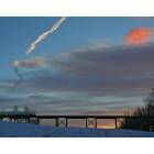
Cornwall: Cornwall Train Trestle

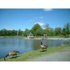
Cornwall: RINGS POND IN CENTER OF TOWN
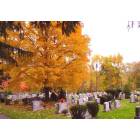
Cornwall: CORNWALL, NEW YORK FALL COLORS IN CEMETARY ON MAILER AVE.

Cornwall: CORNWALL, NEW YORK FALL COLORS !

Cornwall: Deer - Mineral Springs Road
Cornwall: Town Hall Park
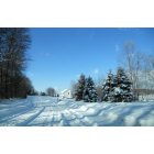
Cornwall: Winter in Cornwall - Waterview Terrace

Cornwall: Cornwall Landing October 08
- see
24
more - add
your
Submit your own pictures of this town and show them to the world
- OSM Map
- Google Map
- MSN Map
Population change since 2000: +2.8%
 |
| Males: 6,166 | |
| Females: 6,480 |
| Median resident age: | 41.7 years |
| New York median age: | 40.7 years |
Zip codes: 12518.
| Cornwall: | $101,829 |
| NY: | $79,557 |
Estimated per capita income in 2022: $52,151 (it was $28,509 in 2000)
Cornwall town income, earnings, and wages data
Estimated median house or condo value in 2022: $430,163 (it was $163,800 in 2000)
| Cornwall: | $430,163 |
| NY: | $400,400 |
Mean prices in 2022: all housing units: $402,470; detached houses: $412,906; townhouses or other attached units: $317,146; in 2-unit structures: $460,335; in 3-to-4-unit structures: $414,366; in 5-or-more-unit structures: $465,557; mobile homes: $110,080
Detailed information about poverty and poor residents in Cornwall, NY
Compare current foreclosures near Cornwall, NY:
| Photo | Address | Area | Beds / Baths | Price | Details |
|---|---|---|---|---|---|

|
#1
Harold Ave
Cornwall, NY 12518
|
1,400 sq. feet
|
1 baths 2 beds |
show details | |

|
#2
Mine Hill Rd
Cornwall, NY 12518
|
1,153 sq. feet
|
1 baths 2 beds |
show details | |

|
#3
Main St Apt 2
Cornwall, NY 12518
|
- sq. feet
|
- baths - beds |
show details | |

|
#4
Patti Pl
Hopewell Junction, NY 12533
|
1,400 sq. feet
|
2 baths 3 beds |
$518,900
|
show details |

|
#5
Penny Ln
Marlboro, NY 12542
|
2,514 sq. feet
|
2 baths 3 beds |
$299,900
|
show details |

|
#6
Lenni Lenape Ct
Stony Point, NY 10980
|
3,252 sq. feet
|
3 baths 4 beds |
$699,900
|
show details |

|
#7
Dorothy Hts
Wappingers Falls, NY 12590
|
1,113 sq. feet
|
1 baths 3 beds |
$389,900
|
show details |

|
#8
Maiden Ln
Maybrook, NY 12543
|
770 sq. feet
|
1 baths 2 beds |
$345,000
|
show details |

|
#9
New Unionville Rd
Wallkill, NY 12589
|
- sq. feet
|
1 baths 5 beds |
$199,500
|
show details |

|
#10
Lyons Ln
Milton, NY 12547
|
1,872 sq. feet
|
2 baths 3 beds |
$34,900
|
show details |
| Photo | Address | Area | Beds / Baths | Price | Details |
|---|---|---|---|---|---|

|
#11
Orchard St
Walden, NY 12586
|
1,236 sq. feet
|
1 baths 2 beds |
$89,900
|
show details |

|
#12
Drew Ave
Highland Falls, NY 10928
|
1,724 sq. feet
|
2 baths 4 beds |
show details | |

|
#13
Lexington Hl # 7
Harriman, NY 10926
|
950 sq. feet
|
2 baths 2 beds |
show details | |

|
#14
River Rd
Walden, NY 12586
|
2,534 sq. feet
|
3 baths 3 beds |
show details | |

|
#15
Cooper Rd
Fishkill, NY 12524
|
1,346 sq. feet
|
2 baths 2 beds |
show details | |

|
#16
St Andrews Ct
Middletown, NY 10941
|
- sq. feet
|
3 baths 4 beds |
show details | |

|
#17
Stanley Rd
Garnerville, NY 10923
|
1,098 sq. feet
|
2 baths 2 beds |
show details | |

|
#18
Zarriello Ln
West Haverstraw, NY 10993
|
1,350 sq. feet
|
2 baths 3 beds |
show details | |

|
#19
Patricia Ln
Washingtonville, NY 10992
|
1,310 sq. feet
|
1 baths 2 beds |
show details | |

|
#20
Paddock Pl
Newburgh, NY 12550
|
1,404 sq. feet
|
2 baths 3 beds |
show details |
| Photo | Address | Area | Beds / Baths | Price | Details |
|---|---|---|---|---|---|

|
#21
Captain Shankey Dr
Garnerville, NY 10923
|
981 sq. feet
|
1 baths 2 beds |
show details | |

|
#22
Route 9w # 9
Newburgh, NY 12550
|
1,314 sq. feet
|
1 baths 4 beds |
show details | |

|
#23
Scotchtown Collabar Rd
Middletown, NY 10941
|
2,887 sq. feet
|
3 baths 4 beds |
show details | |

|
#24
Jessen Pl
Beacon, NY 12508
|
1,934 sq. feet
|
2 baths 4 beds |
show details | |

|
#25
Oakland Ave
Central Valley, NY 10917
|
1,904 sq. feet
|
2 baths 4 beds |
show details | |

|
#26
All Angels Hill Rd
Wappingers Falls, NY 12590
|
1,196 sq. feet
|
2 baths 3 beds |
show details | |

|
#27
Acorn Ct
Wappingers Falls, NY 12590
|
2,821 sq. feet
|
2 baths 4 beds |
show details | |

|
#28
Alfred Pl
Walden, NY 12586
|
1,544 sq. feet
|
1 baths 3 beds |
show details | |

|
#29
Friendly Rd
Mahopac, NY 10541
|
1,808 sq. feet
|
1 baths 4 beds |
show details | |

|
#30
Edgewood Trl
Monroe, NY 10950
|
916 sq. feet
|
2 baths 2 beds |
show details |
| Photo | Address | Area | Beds / Baths | Price | Details |
|---|---|---|---|---|---|

|
#31
South St
Marlboro, NY 12542
|
1,637 sq. feet
|
1 baths 2 beds |
show details | |

|
#32
Stowe Rd
Peekskill, NY 10566
|
- sq. feet
|
2 baths 4 beds |
show details | |

|
#33
James St
Stony Point, NY 10980
|
1,134 sq. feet
|
1 baths 2 beds |
show details | |

|
#34
Timber Ct
Highland, NY 12528
|
2,792 sq. feet
|
2 baths 3 beds |
show details | |

|
#35
Walnut Dr
Mahopac, NY 10541
|
2,284 sq. feet
|
2 baths 4 beds |
show details | |

|
#36
Crompond Rd Apt B6
Peekskill, NY 10566
|
900 sq. feet
|
1 baths 2 beds |
show details | |

|
#37
Pickerel Rd
Monroe, NY 10950
|
2,092 sq. feet
|
1 baths 2 beds |
show details | |

|
#38
Concord St
Newburgh, NY 12550
|
1,548 sq. feet
|
1 baths 3 beds |
show details | |

|
#39
Miller Hill Rd
Carmel, NY 10512
|
816 sq. feet
|
1 baths 1 beds |
show details | |

|
#40
Purse Ln # 12533
Hopewell Junction, NY 12533
|
910 sq. feet
|
1 baths 2 beds |
show details |
| Photo | Address | Area | Beds / Baths | Price | Details |
|---|---|---|---|---|---|

|
#41
Howard Dr
Middletown, NY 10941
|
1,892 sq. feet
|
2 baths 3 beds |
show details | |

|
#42
Route 376
Wappingers Falls, NY 12590
|
1,894 sq. feet
|
1 baths 3 beds |
show details | |

|
#43
Hillside Ave
New Windsor, NY 12553
|
2,114 sq. feet
|
2 baths 5 beds |
show details | |

|
#44
Cartwright Rd
Stony Point, NY 10980
|
1,800 sq. feet
|
3 baths 6 beds |
show details | |

|
#45
Brooks Dr
Stony Point, NY 10980
|
1,449 sq. feet
|
1 baths 3 beds |
show details | |

|
#46
Darian Ct Apt 1b
Pomona, NY 10970
|
825 sq. feet
|
1 baths 1 beds |
show details | |

|
#47
Entrance Way
Mahopac, NY 10541
|
628 sq. feet
|
1 baths 2 beds |
show details | |

|
#48
Walnut Dr
Mahopac, NY 10541
|
1,921 sq. feet
|
2 baths 4 beds |
show details | |

|
#49
All Angels Hill Rd
Wappingers Falls, NY 12590
|
2,789 sq. feet
|
2 baths 3 beds |
show details | |

|
Check over 1 million property listings on Foreclosure.com!
|
browse all offers | |||

- 10,91686.3%White alone
- 1,0468.3%Hispanic
- 2211.7%Black alone
- 2121.7%Asian alone
- 2071.6%Two or more races
- 280.2%American Indian alone
- 110.09%Other race alone
- 50.04%Native Hawaiian and Other
Pacific Islander alone
Races in Cornwall detailed stats: ancestries, foreign born residents, place of birth
According to our research of New York and other state lists, there were 3 registered sex offenders living in Cornwall, New York as of April 30, 2024.
The ratio of all residents to sex offenders in Cornwall is 4,215 to 1.
The ratio of registered sex offenders to all residents in this city is much lower than the state average.
Type |
2009 |
2010 |
2011 |
2012 |
2013 |
2014 |
2015 |
2016 |
2017 |
2018 |
2019 |
2020 |
2022 |
|---|---|---|---|---|---|---|---|---|---|---|---|---|---|
| Murders (per 100,000) | 0 (0.0) | 0 (0.0) | 0 (0.0) | 0 (0.0) | 0 (0.0) | 0 (0.0) | 0 (0.0) | 0 (0.0) | 0 (0.0) | 0 (0.0) | 0 (0.0) | 0 (0.0) | 0 (0.0) |
| Rapes (per 100,000) | 0 (0.0) | 0 (0.0) | 0 (0.0) | 1 (10.3) | 0 (0.0) | 0 (0.0) | 0 (0.0) | 1 (10.4) | 0 (0.0) | 0 (0.0) | 1 (10.5) | 0 (0.0) | 0 (0.0) |
| Robberies (per 100,000) | 0 (0.0) | 0 (0.0) | 0 (0.0) | 0 (0.0) | 0 (0.0) | 0 (0.0) | 1 (10.5) | 0 (0.0) | 0 (0.0) | 1 (10.5) | 0 (0.0) | 0 (0.0) | 1 (10.2) |
| Assaults (per 100,000) | 0 (0.0) | 0 (0.0) | 3 (31.0) | 1 (10.3) | 1 (10.5) | 0 (0.0) | 4 (42.1) | 3 (31.3) | 2 (21.0) | 0 (0.0) | 1 (10.5) | 2 (21.0) | 1 (10.2) |
| Burglaries (per 100,000) | 8 (81.5) | 6 (62.3) | 13 (134.4) | 14 (143.8) | 10 (104.8) | 9 (94.5) | 11 (115.7) | 3 (31.3) | 4 (41.9) | 0 (0.0) | 2 (21.0) | 1 (10.5) | 2 (20.3) |
| Thefts (per 100,000) | 62 (631.7) | 69 (716.7) | 89 (920.3) | 74 (760.1) | 32 (335.3) | 38 (398.9) | 23 (241.8) | 25 (260.7) | 17 (178.1) | 17 (177.9) | 5 (52.6) | 3 (31.5) | 15 (152.4) |
| Auto thefts (per 100,000) | 0 (0.0) | 0 (0.0) | 2 (20.7) | 0 (0.0) | 0 (0.0) | 0 (0.0) | 1 (10.5) | 1 (10.4) | 0 (0.0) | 1 (10.5) | 0 (0.0) | 0 (0.0) | 0 (0.0) |
| Arson (per 100,000) | 1 (10.2) | 0 (0.0) | 0 (0.0) | 0 (0.0) | 0 (0.0) | 0 (0.0) | 0 (0.0) | 0 (0.0) | 0 (0.0) | 0 (0.0) | 0 (0.0) | 0 (0.0) | 0 (0.0) |
| City-Data.com crime index | 31.0 | 33.0 | 54.1 | 50.7 | 22.8 | 22.6 | 30.2 | 28.1 | 14.2 | 11.1 | 14.1 | 6.2 | 12.6 |
The City-Data.com crime index weighs serious crimes and violent crimes more heavily. Higher means more crime, U.S. average is 246.1. It adjusts for the number of visitors and daily workers commuting into cities.
Crime rate in Cornwall detailed stats: murders, rapes, robberies, assaults, burglaries, thefts, arson
Full-time law enforcement employees in 2021, including police officers: 12 (10 officers - 10 male; 0 female).
| Officers per 1,000 residents here: | 1.06 |
| New York average: | 3.28 |
 Recent articles from our blog. Our writers, many of them Ph.D. graduates or candidates, create easy-to-read articles on a wide variety of topics.
Ancestries: Irish (27.2%), Italian (23.4%), German (17.9%), English (10.4%), Polish (5.1%), United States (4.2%).
Current Local Time: EST time zone
Land area: 26.8 square miles.
Population density: 471 people per square mile (low).
711 residents are foreign born (3.1% Europe, 1.6% Asia, 1.0% Latin America).
| This town: | 5.8% |
| New York: | 20.4% |
| Cornwall town: | 2.7% ($4,491) |
| New York: | 1.9% ($2,847) |
Nearest city with pop. 50,000+: Clarkstown, NY  (21.4 miles , pop. 82,082).
Nearest city with pop. 200,000+: Bronx, NY (41.5 miles , pop. 1,332,650).
Nearest cities:
), ), ), ), ), Latitude: 41.43 N, Longitude: 74.05 W
Area code: 845
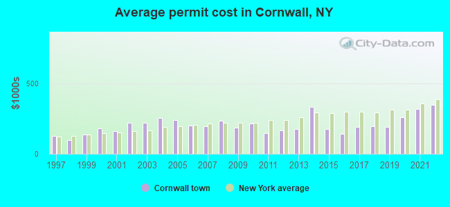
Single-family new house construction building permits:
- 2022: 6 buildings, average cost: $348,300
- 2021: 6 buildings, average cost: $319,300
- 2020: 7 buildings, average cost: $259,700
- 2019: 9 buildings, average cost: $189,400
- 2018: 17 buildings, average cost: $193,100
- 2017: 12 buildings, average cost: $190,300
- 2016: 1 building, cost: $140,000
- 2015: 9 buildings, average cost: $177,200
- 2014: 4 buildings, average cost: $334,300
- 2013: 9 buildings, average cost: $174,400
- 2012: 12 buildings, average cost: $167,700
- 2011: 4 buildings, average cost: $147,800
- 2010: 9 buildings, average cost: $213,900
- 2009: 3 buildings, average cost: $186,700
- 2008: 7 buildings, average cost: $231,600
- 2007: 11 buildings, average cost: $194,100
- 2006: 30 buildings, average cost: $198,500
- 2005: 22 buildings, average cost: $236,600
- 2004: 46 buildings, average cost: $254,000
- 2003: 29 buildings, average cost: $221,800
- 2002: 35 buildings, average cost: $220,300
- 2001: 34 buildings, average cost: $160,800
- 2000: 20 buildings, average cost: $181,400
- 1999: 36 buildings, average cost: $135,600
- 1998: 89 buildings, average cost: $99,900
- 1997: 58 buildings, average cost: $124,800
| Here: | 3.9% |
| New York: | 4.4% |
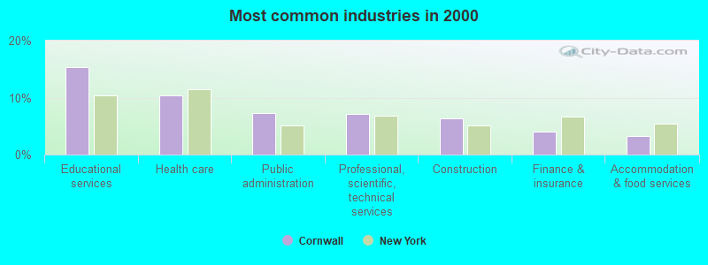
- Educational services (15.4%)
- Health care (10.4%)
- Public administration (7.3%)
- Professional, scientific, technical services (7.1%)
- Construction (6.3%)
- Finance & insurance (4.1%)
- Accommodation & food services (3.2%)
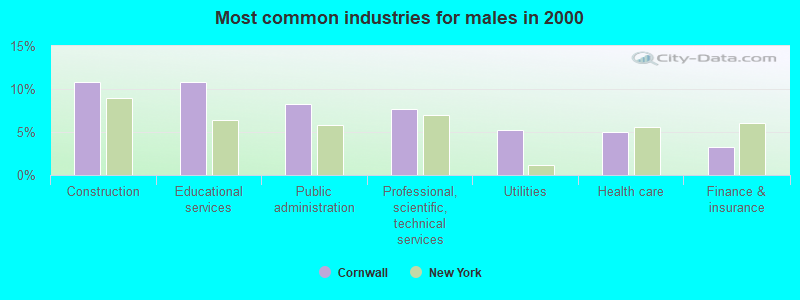
- Construction (10.8%)
- Educational services (10.8%)
- Public administration (8.3%)
- Professional, scientific, technical services (7.7%)
- Utilities (5.2%)
- Health care (5.0%)
- Finance & insurance (3.2%)
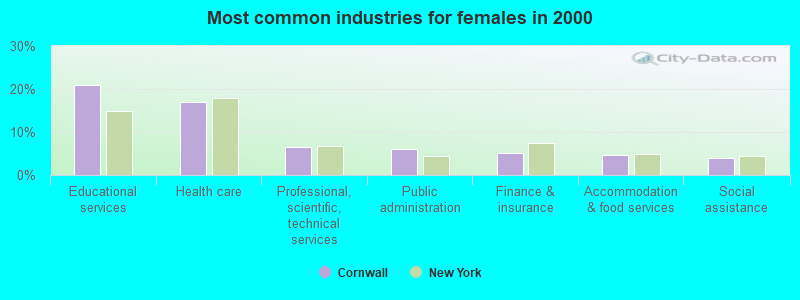
- Educational services (20.9%)
- Health care (17.0%)
- Professional, scientific, technical services (6.5%)
- Public administration (6.0%)
- Finance & insurance (5.1%)
- Accommodation & food services (4.7%)
- Social assistance (3.9%)
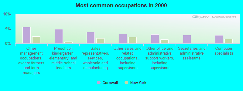
- Other management occupations, except farmers and farm managers (5.5%)
- Preschool, kindergarten, elementary, and middle school teachers (4.9%)
- Sales representatives, services, wholesale and manufacturing (3.9%)
- Other sales and related occupations, including supervisors (3.3%)
- Other office and administrative support workers, including supervisors (3.1%)
- Secretaries and administrative assistants (2.9%)
- Computer specialists (2.8%)
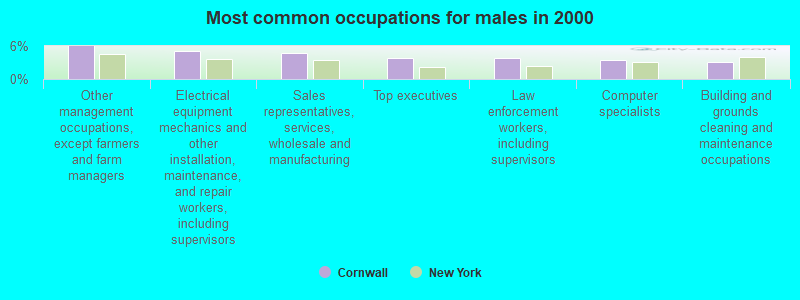
- Other management occupations, except farmers and farm managers (6.0%)
- Electrical equipment mechanics and other installation, maintenance, and repair workers, including supervisors (5.0%)
- Sales representatives, services, wholesale and manufacturing (4.8%)
- Top executives (3.8%)
- Law enforcement workers, including supervisors (3.8%)
- Computer specialists (3.4%)
- Building and grounds cleaning and maintenance occupations (3.2%)
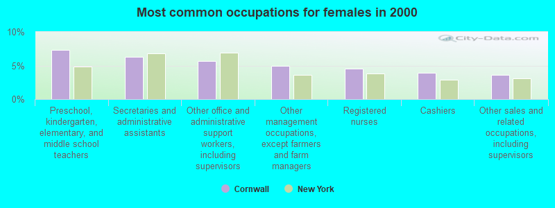
- Preschool, kindergarten, elementary, and middle school teachers (7.3%)
- Secretaries and administrative assistants (6.3%)
- Other office and administrative support workers, including supervisors (5.6%)
- Other management occupations, except farmers and farm managers (5.0%)
- Registered nurses (4.6%)
- Cashiers (3.9%)
- Other sales and related occupations, including supervisors (3.6%)
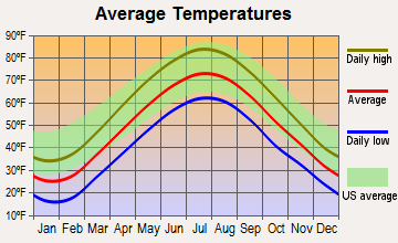
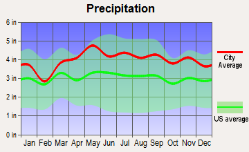
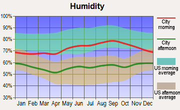
Average climate in Cornwall, New York
Based on data reported by over 4,000 weather stations
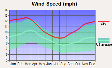
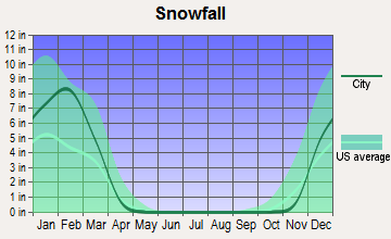
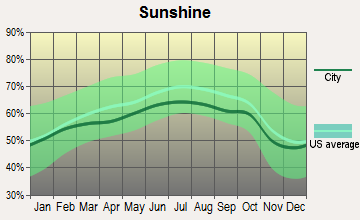
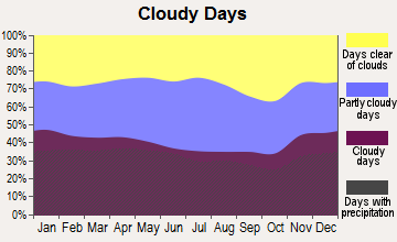
(lower is better)
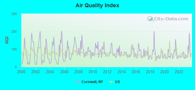
Air Quality Index (AQI) level in 2023 was 89.0. This is worse than average.
| City: | 89.0 |
| U.S.: | 72.6 |
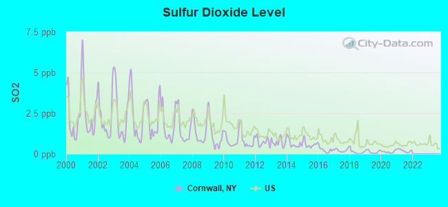
Sulfur Dioxide (SO2) [ppb] level in 2021 was 0.196. This is significantly better than average. Closest monitor was 9.0 miles away from the city center.
| City: | 0.196 |
| U.S.: | 1.515 |
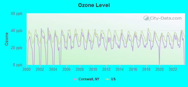
Ozone [ppb] level in 2023 was 30.3. This is about average. Closest monitor was 5.5 miles away from the city center.
| City: | 30.3 |
| U.S.: | 33.3 |
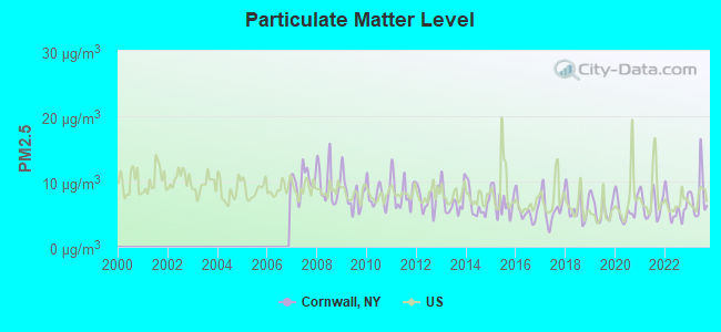
Particulate Matter (PM2.5) [µg/m3] level in 2023 was 7.78. This is about average. Closest monitor was 5.2 miles away from the city center.
| City: | 7.78 |
| U.S.: | 8.11 |
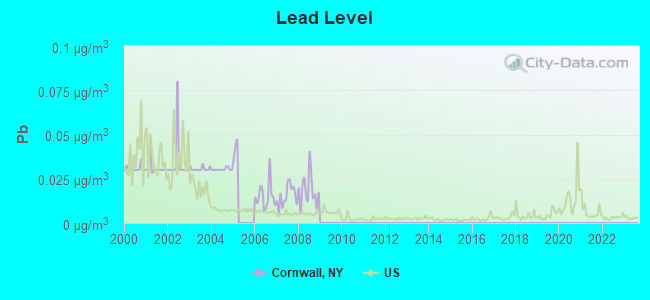
Lead (Pb) [µg/m3] level in 2008 was 0.0185. This is significantly worse than average. Closest monitor was 16.2 miles away from the city center.
| City: | 0.0185 |
| U.S.: | 0.0093 |
Tornado activity:
Cornwall-area historical tornado activity is above New York state average. It is 33% smaller than the overall U.S. average.
On 7/14/1988, a category F3 (max. wind speeds 158-206 mph) tornado 22.7 miles away from the Cornwall town center injured one person and caused between $500,000 and $5,000,000 in damages.
On 7/29/1971, a category F2 (max. wind speeds 113-157 mph) tornado 3.6 miles away from the town center caused between $50,000 and $500,000 in damages.
Earthquake activity:
Cornwall-area historical earthquake activity is significantly above New York state average. It is 68% smaller than the overall U.S. average.On 10/7/1983 at 10:18:46, a magnitude 5.3 (5.1 MB, 5.3 LG, 5.1 ML, Class: Moderate, Intensity: VI - VII) earthquake occurred 175.1 miles away from the city center
On 4/20/2002 at 10:50:47, a magnitude 5.3 (5.3 ML, Depth: 3.0 mi) earthquake occurred 213.9 miles away from Cornwall center
On 8/23/2011 at 17:51:04, a magnitude 5.8 (5.8 MW, Depth: 3.7 mi) earthquake occurred 319.4 miles away from the city center
On 4/20/2002 at 10:50:47, a magnitude 5.2 (5.2 MB, 4.2 MS, 5.2 MW, 5.0 MW) earthquake occurred 212.1 miles away from Cornwall center
On 1/16/1994 at 01:49:16, a magnitude 4.6 (4.6 MB, 4.6 LG, Depth: 3.1 mi, Class: Light, Intensity: IV - V) earthquake occurred 128.7 miles away from the city center
On 1/19/1982 at 00:14:42, a magnitude 4.7 (4.5 MB, 4.7 MD, 4.5 LG) earthquake occurred 190.1 miles away from Cornwall center
Magnitude types: regional Lg-wave magnitude (LG), body-wave magnitude (MB), duration magnitude (MD), local magnitude (ML), surface-wave magnitude (MS), moment magnitude (MW)
Natural disasters:
The number of natural disasters in Orange County (28) is a lot greater than the US average (15).Major Disasters (Presidential) Declared: 18
Emergencies Declared: 9
Causes of natural disasters: Floods: 8, Storms: 8, Hurricanes: 7, Blizzards: 2, Snowstorms: 2, Tropical Storms: 2, Fire: 1, Power Outage: 1, Tropical Depression: 1, Water Shortage: 1, Other: 3 (Note: some incidents may be assigned to more than one category).
Hospitals and medical centers near Cornwall:
- LIBERTY HUDSON VALLEY DIALYSIS (Dialysis Facility, about 5 miles away; NEWBURGH, NY)
- ELANT AT GOSHEN INC LTHHCP (Home Health Center, about 5 miles away; NEWBURGH, NY)
- HOSPICE OF ORANGE AND SULLIVAN COUNTIES INC (Hospital, about 5 miles away; NEWBURGH, NY)
- AMERICAN CARE INC CLOSED (Home Health Center, about 6 miles away; NEWBURGH, NY)
- ST LUKE'S CORNWALL HOSPITAL Acute Care Hospitals (about 6 miles away; NEWBURGH, NY)
- ST LUKES HOSPITAL (Hospital, about 6 miles away; NEWBURGH, NY)
- WILLCARE HUDSON VALLEY CHHA (Home Health Center, about 6 miles away; NEWBURGH, NY)
Heliports located in Cornwall:
Amtrak stations near Cornwall:
- 19 miles: CROTON-HARMON (CROTON-ON-HUDSON, CROTON POINT AVE.) . Services: partially wheelchair accessible, enclosed waiting area, public restrooms, public payphones, snack bar, paid short-term parking, paid long-term parking, call for car rental service, call for taxi service, public transit connection.
- 20 miles: POUGHKEEPSIE (41 MAIN ST.) . Services: partially wheelchair accessible, enclosed waiting area, public restrooms, public payphones, snack bar, paid short-term parking, paid long-term parking, call for car rental service, taxi stand, public transit connection.
Operable nuclear power plants near Cornwall:
- 14 miles: Indian Point 2 and 3 in Buchanan, NY.
Colleges/universities with over 2000 students nearest to Cornwall:
- United States Military Academy (about 6 miles; West Point, NY; Full-time enrollment: 5,651)
- Mount Saint Mary College (about 6 miles; Newburgh, NY; FT enrollment: 2,166)
- Orange County Community College (about 20 miles; Middletown, NY; FT enrollment: 4,742)
- Vassar College (about 20 miles; Poughkeepsie, NY; FT enrollment: 2,469)
- Rockland Community College (about 21 miles; Suffern, NY; FT enrollment: 6,026)
- Marist College (about 22 miles; Poughkeepsie, NY; FT enrollment: 5,536)
- State University of New York at New Paltz (about 22 miles; New Paltz, NY; FT enrollment: 7,319)
Public elementary/middle schools in Cornwall:
- CORNWALL MIDDLE SCHOOL (Students: 1,038, Location: 122 MAIN ST, Grades: 5-8)
- CORNWALL ELEMENTARY SCHOOL (Students: 630, Location: 99 LEE RD, Grades: KG-4)
- WILLOW AVENUE ELEMENTARY SCHOOL (Students: 365, Location: 67 WILLOW AVE, Grades: KG-4)
Private elementary/middle school in Cornwall:
User-submitted facts and corrections:
- Cornwall-On-Hudson ES- approx. 275 students and is located at 234 Hudson Street
- Birthplace of Indian Larry
- Donald Trump had attended the New York Military Academy(NYMA)here in Cornwall
Points of interest:
Notable locations in Cornwall: Woodbury Country Club (A), Storm King Golf Club (B), Metro-North Salisbury Mills-Cornwall Station (C), Cornwall Industrial Park (D), Jones Farm (E), Hudson Highlands Nature Museum (F), Storm King Theatre (G), Cornwall - on - Hudson Fire Department Storm King Fire Engine Company 2 (H), Cornwall Fire Department Highland Engine Company 1 (I), Cornwall Town Hall (J), Cornwall Public Library (K), Cornwall Fire Department Mountainville Engine Company 3 (L). Display/hide their locations on the map
Shopping Center: Cornwall Plaza Shopping Center (1). Display/hide its location on the map
Churches in Cornwall include: Cornwall Presbyterian Church (A), Saint Thomas of Canterbury Church (B), Saint John's Episcopal Church (C), Friends Meeting At Cornwall (D), Cornwall United Methodist Church (E), Cornwall Baptist Church (F), Maranatha Bible Church (G), Mountainville Methodist Church (H), Kingdom Hall of Jehovah's Witnesses (I). Display/hide their locations on the map
Cemeteries: Saint Thomas Cemetery (1), Willow Dell Cemetery (2), Edwards Cemetery (3), Pleasant Hill Cemetery (4). Display/hide their locations on the map
Lakes and reservoirs: Rings Pond (A), Sutherland Pond (B), Aleck Meadow Reservoir (C), Sphagnum Pond (D), Breeds Pond (E), Upper Reservoir (F). Display/hide their locations on the map
Streams, rivers, and creeks: Woodbury Creek (A), Baby Brook (B), Moodna Creek (C). Display/hide their locations on the map
Parks in Cornwall include: Riverlight Park (1), Monument Park (2), Storm King State Park (3), Sand Ring Park (4), Laurel Creek Park (5). Display/hide their locations on the map
Hotel: Cadet Motel (9 West By Passage) (1). Display/hide its approximate location on the map
Birthplace of: Rob Cohen - Film director, Bonnie Blair - (born 1964), Olympic gold medalist in speed skating, Phil Missere - College basketball player (St. John's Red Storm), Shea Farrell - Actor, George Bucci - Basketball player.
Drinking water stations with addresses in Cornwall and their reported violations in the past:
JONES FARM (Address: 190 ANGOLA ROAD , Population served: 26, Groundwater):Past monitoring violations:CROMWELL MANOR (Address: 174 ANGOLA ROAD , Population served: 25, Groundwater):
- 3 routine major monitoring violations
- One regular monitoring violation
Past monitoring violations:
- 6 routine major monitoring violations
- One regular monitoring violation
| This town: | 2.6 people |
| New York: | 2.6 people |
| This town: | 71.6% |
| Whole state: | 63.5% |
| This town: | 5.4% |
| Whole state: | 6.8% |
Likely homosexual households (counted as self-reported same-sex unmarried-partner households)
- Lesbian couples: 0.4% of all households
- Gay men: 0.4% of all households
| This town: | 5.0% |
| Whole state: | 14.6% |
| This town: | 2.6% |
| Whole state: | 7.4% |
People in group quarters in Cornwall in 2010:
- 64 people in workers' group living quarters and job corps centers
- 31 people in group homes intended for adults
- 18 people in emergency and transitional shelters (with sleeping facilities) for people experiencing homelessness
- 11 people in other noninstitutional facilities
- 6 people in group homes for juveniles (non-correctional)
- 6 people in college/university student housing
People in group quarters in Cornwall in 2000:
- 25 people in other noninstitutional group quarters
- 19 people in homes for the mentally retarded
- 8 people in homes for the mentally ill
- 3 people in mental (psychiatric) hospitals or wards
- 2 people in religious group quarters
Banks with branches in Cornwall (2011 data):
- Bank of America, National Association: Cornwall Branch at 25 Quaker Avenue, branch established on 1968/05/01. Info updated 2009/11/18: Bank assets: $1,451,969.3 mil, Deposits: $1,077,176.8 mil, headquarters in Charlotte, NC, positive income, 5782 total offices, Holding Company: Bank Of America Corporation
- JPMorgan Chase Bank, National Association: Cornwall Branch at 257 Main Street, branch established on 1956/01/30. Info updated 2011/11/10: Bank assets: $1,811,678.0 mil, Deposits: $1,190,738.0 mil, headquarters in Columbus, OH, positive income, International Specialization, 5577 total offices, Holding Company: Jpmorgan Chase & Co.
For population 15 years and over in Cornwall:
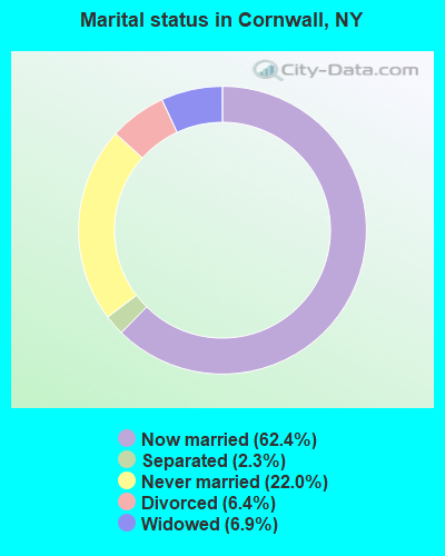
- Never married: 22.0%
- Now married: 62.4%
- Separated: 2.3%
- Widowed: 6.9%
- Divorced: 6.4%
For population 25 years and over in Cornwall:
- High school or higher: 90.8%
- Bachelor's degree or higher: 35.6%
- Graduate or professional degree: 17.2%
- Unemployed: 3.4%
- Mean travel time to work (commute): 31.4 minutes

| Here: | 10.8 |
| New York average: | 14.2 |
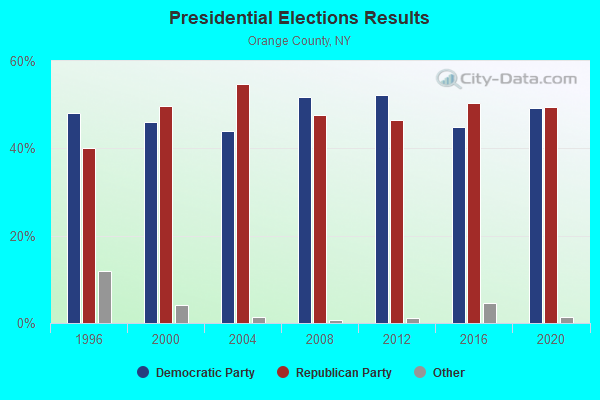
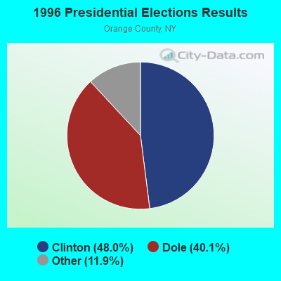
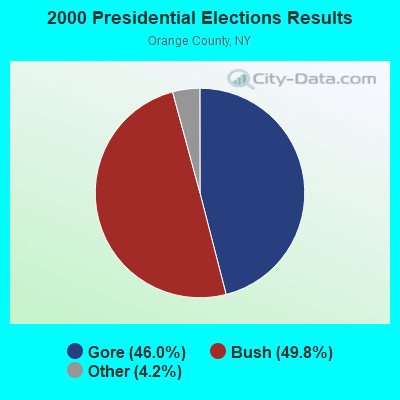
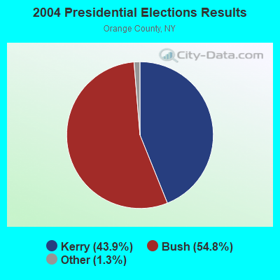
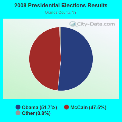
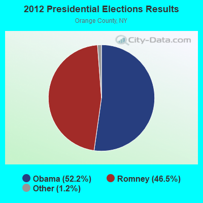
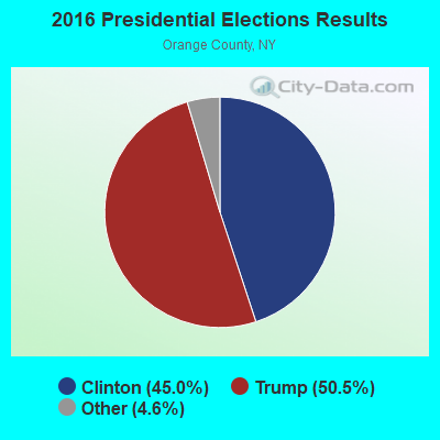
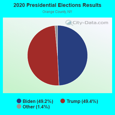
Graphs represent county-level data. Detailed 2008 Election Results
Religion statistics for Cornwall, NY (based on Orange County data)
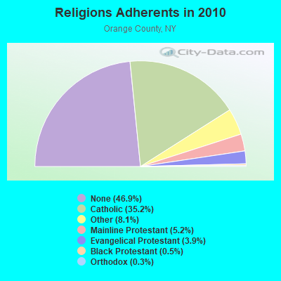
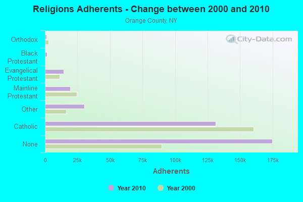
| Religion | Adherents | Congregations |
|---|---|---|
| Catholic | 131,308 | 45 |
| Other | 30,221 | 42 |
| Mainline Protestant | 19,326 | 88 |
| Evangelical Protestant | 14,437 | 95 |
| Black Protestant | 1,711 | 9 |
| Orthodox | 973 | 6 |
| None | 174,837 | - |
Food Environment Statistics:
| This county: | 3.00 / 10,000 pop. |
| New York: | 4.13 / 10,000 pop. |
| Orange County: | 0.11 / 10,000 pop. |
| State: | 0.06 / 10,000 pop. |
| Here: | 1.22 / 10,000 pop. |
| New York: | 0.92 / 10,000 pop. |
| Here: | 2.50 / 10,000 pop. |
| New York: | 1.68 / 10,000 pop. |
| This county: | 8.34 / 10,000 pop. |
| New York: | 8.82 / 10,000 pop. |
| Orange County: | 8.6% |
| State: | 8.2% |
| Orange County: | 25.9% |
| New York: | 23.8% |
| This county: | 13.3% |
| New York: | 15.6% |
6.30% of this county's 2021 resident taxpayers lived in other counties in 2020 ($81,451 average adjusted gross income)
| Here: | 6.30% |
| New York average: | 5.29% |
0.03% of residents moved from foreign countries ($369 average AGI)
Orange County: 0.03% New York average: 0.01%
Top counties from which taxpayers relocated into this county between 2020 and 2021:
| from Bronx County, NY | |
| from Kings County, NY | |
| from Rockland County, NY |
6.58% of this county's 2020 resident taxpayers moved to other counties in 2021 ($77,430 average adjusted gross income)
| Here: | 6.58% |
| New York average: | 6.93% |
0.03% of residents moved to foreign countries ($315 average AGI)
Orange County: 0.03% New York average: 0.02%
Top counties to which taxpayers relocated from this county between 2020 and 2021:
| to Ulster County, NY | |
| to Dutchess County, NY | |
| to Sullivan County, NY |
| Businesses in Cornwall, NY | ||||
| Name | Count | Name | Count | |
|---|---|---|---|---|
| CVS | 1 | MasterBrand Cabinets | 1 | |
| Decora Cabinetry | 1 | Subway | 1 | |
| Dunkin Donuts | 1 | UPS | 2 | |
| FedEx | 1 | |||
Strongest AM radio stations in Cornwall:
- WWLE (1170 AM; daytime; 1 kW; CORNWALL, NY; Owner: 1170 BROADCAST RADIO, INC.)
- WGNY (1220 AM; 10 kW; NEWBURGH, NY; Owner: SUNRISE BROADCASTING LLC)
- WABC (770 AM; 50 kW; NEW YORK, NY; Owner: WABC-AM RADIO, INC.)
- WFAN (660 AM; 50 kW; NEW YORK, NY; Owner: INFINITY BROADCASTING OPERATIONS, INC.)
- WMCA (570 AM; 50 kW; NEW YORK, NY; Owner: SALEM MEDIA OF NEW YORK, LLC)
- WOR (710 AM; 50 kW; NEW YORK, NY; Owner: BUCKLEY BROADCASTING CORPORATION)
- WCBS (880 AM; 50 kW; NEW YORK, NY; Owner: INFINITY BROADCASTING OPERATIONS, INC.)
- WLNA (1420 AM; 5 kW; PEEKSKILL, NY; Owner: 6 JOHNSON ROAD LICENSES, INC.)
- WINS (1010 AM; 50 kW; NEW YORK, NY; Owner: INFINITY BROADCASTING OPERATIONS, INC.)
- WEPN (1050 AM; 50 kW; NEW YORK, NY; Owner: NEW YORK AM RADIO, LLC)
- WBNR (1260 AM; 1 kW; BEACON, NY; Owner: 6 JOHNSON ROAD LICENSES, INC.)
- WBBR (1130 AM; 50 kW; NEW YORK, NY; Owner: BLOOMBERG COMMUNICATIONS INC.)
- WSNR (620 AM; 20 kW; JERSEY CITY, NJ)
Strongest FM radio stations in Cornwall:
- W202AR (88.3 FM; NEWBURGH, NY; Owner: SOUND OF LIFE, INC.)
- W299AG (107.7 FM; NEWBURGH, NY; Owner: WAMC)
- W272AV (102.3 FM; NEWBURGH, NY; Owner: JOHN KATONAH)
- WLJP (89.3 FM; MONROE, NY; Owner: SOUND OF LIFE, INC.)
- WSPK (104.7 FM; POUGHKEEPSIE, NY; Owner: 6 JOHNSON ROAD LICENSES, INC.)
- WGNY-FM (103.1 FM; NEWBURGH, NY; Owner: SUNRISE BROADCASTING LLC)
- WPDH (101.5 FM; POUGHKEEPSIE, NY; Owner: CUMULUS LICENSING CORP.)
- WFKP (99.3 FM; ELLENVILLE, NY; Owner: CLEAR CHANNEL BROADCASTING LICENSES, INC.)
- WFNP (88.7 FM; ROSENDALE, NY; Owner: STATE UNIVERSITY OF NEW YORK)
- WRHV (88.7 FM; POUGHKEEPSIE, NY; Owner: WMHT EDUCATIONAL TELECOMMUNICATIONS)
- WHUD (100.7 FM; PEEKSKILL, NY; Owner: 6 JOHNSON ROAD LICENSES, INC.)
- WBWZ (93.3 FM; NEW PALTZ, NY; Owner: CLEVELAND RADIO LICENSES, LLC)
- WRWD-FM (107.3 FM; HIGHLAND, NY; Owner: CLEVELAND RADIO LICENSES, LLC)
- WCZX (97.7 FM; HYDE PARK, NY; Owner: CUMULUS LICENSING CORP.)
- WRRB (96.9 FM; ARLINGTON, NY; Owner: CUMULUS LICENSING CORP.)
- WRNQ (92.1 FM; POUGHKEEPSIE, NY; Owner: CLEAR CHANNEL BROADCASTING LICENSES, INC.)
- W292CM (106.3 FM; POUGHKEEPSIE, NY; Owner: JOHN KATONAH)
- W213AM (90.5 FM; NEWBURGH, NY; Owner: FAMILY STATIONS, INC.)
- WPLJ (95.5 FM; NEW YORK, NY; Owner: WPLJ-FM RADIO, INC.)
- WDBY (105.5 FM; PATTERSON, NY; Owner: CUMULUS LICENSING CORP.)
TV broadcast stations around Cornwall:
- WTBY (Channel 54; POUGHKEEPSIE, NY; Owner: TRINITY BROADCASTING OF NEW YORK, INC.)
- WRNN-TV (Channel 62; KINGSTON, NY; Owner: WRNN-TV ASSOCIATES LIMITED PARTNERSHIP)
- WFME-TV (Channel 66; WEST MILFORD, NJ; Owner: FAMILY STATIONS, INC.)
- WNYW (Channel 5; NEW YORK, NY; Owner: FOX TELEVISION STATIONS, INC.)
- WCBS-TV (Channel 2; NEW YORK, NY; Owner: CBS BROADCASTING INC.)
- WABC-TV (Channel 7; NEW YORK, NY; Owner: AMERICAN BROADCASTING COMPANIES, INC)
- WPIX (Channel 11; NEW YORK, NY; Owner: WPIX, INC.)
- WWOR-TV (Channel 9; SECAUCUS, NJ; Owner: FOX TELEVISION STATIONS, INC.)
- WNJU (Channel 47; LINDEN, NJ; Owner: WNJU LICENSE CORPORATION)
- WPXN-TV (Channel 31; NEW YORK, NY; Owner: PAXSON COMMUNICATIONS LICENSE COMPANY, LLC)
- WFUT (Channel 68; NEWARK, NJ; Owner: UNIVISION NEW YORK LLC)
- WXNY-LP (Channel 32; NEW YORK, NY; Owner: ISLAND BROADCASTING COMPANY)
- WNBC (Channel 4; NEW YORK, NY; Owner: NATIONAL BROADCASTING COMPANY, INC.)
- WNET (Channel 13; NEWARK, NJ; Owner: EDUCATIONAL BROADCASTING CORPORATION)
- WXTV (Channel 41; PATERSON, NJ; Owner: WXTV LICENSE PARTNERSHIP, G.P.)
- WNYE-TV (Channel 25; NEW YORK, NY; Owner: NEW YORK CITY BOARD OF EDUCATION)
- WPXO-LP (Channel 34; EAST ORANGE, NJ; Owner: PAXSON COMMUNICATIONS LPTV, INC.)
- W68DN (Channel 68; CHERRY HILL, ETC., NJ; Owner: MARCIA COHEN)
- WKOB-LP (Channel 53; NEW YORK, NY; Owner: WKOB COMMUNICATIONS, INC.)
- WEBR-CA (Channel 17; MANHATTAN, NY; Owner: K LICENSEE INC.)
- WRNN-LP (Channel 57; NYACK, NY; Owner: LP NYACK LIMITED PARTNERSHIP)
- National Bridge Inventory (NBI) Statistics
- 31Number of bridges
- 226ft / 69.1mTotal length
- $68,699,000Total costs
- 333,188Total average daily traffic
- 19,121Total average daily truck traffic
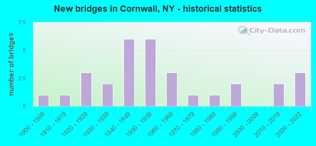
- New bridges - historical statistics
- 11900-1909
- 11910-1919
- 31920-1929
- 21930-1939
- 61940-1949
- 61950-1959
- 31960-1969
- 11970-1979
- 11980-1989
- 21990-1999
- 22010-2019
- 32020-2022
FCC Registered Broadcast Land Mobile Towers:
5- Int Quaker Ave & Angolo Rd (Lat: 41.434528 Lon: -74.035417), Call Sign: KNDK596, Licensee ID: L00113760,
Assigned Frequencies: 154.205 MHz, Grant Date: 08/15/2002, Expiration Date: 08/24/2012, Cancellation Date: 10/27/2012, Registrant: Canterbury Fire District, Cornwall, NY 12518
- 183 Main St (Lat: 41.438972 Lon: -74.028472), Type: Tower, Structure height: 15.2 m, Overall height: 21.3 m, Call Sign: KGU738,
Assigned Frequencies: 154.875 MHz, 155.370 MHz, Grant Date: 02/25/2022, Expiration Date: 04/01/2032, Registrant: New York Communications Co. Inc., 53 W. Cedar St., Poughkeepsie, NY 12601, Phone: (845) 471-5520, Fax: (845) 471-5593, Email:
- 3 River Rd (Lat: 41.441750 Lon: -74.005139), Type: Tower, Structure height: 52 m, Call Sign: KIL465,
Assigned Frequencies: 154.875 MHz, 155.370 MHz, Grant Date: 03/29/2022, Expiration Date: 05/14/2032, Registrant: New York Communications Co Inc, 53 W. Cedar St., Poughkeepsie, NY 12601, Phone: (845) 471-5520, Fax: (845) 471-5593, Email:
- 183 Main St (Lat: 41.438972 Lon: -74.028472), Type: Tower, Structure height: 15.2 m, Overall height: 21.3 m, Call Sign: WCG651,
Assigned Frequencies: 156.090 MHz, Grant Date: 02/25/2022, Expiration Date: 04/01/2032, Registrant: New York Communications Co. Inc., 53 W. Cedar St., Poughkeepsie, NY 12601, Phone: (845) 471-5520, Fax: (845) 471-5593, Email:
- Lat: 41.428694 Lon: -74.026528, Call Sign: WPTZ267,
Assigned Frequencies: 451.362 MHz, 456.362 MHz, Grant Date: 01/12/2012, Expiration Date: 01/16/2022, Cancellation Date: 03/19/2022, Certifier: George Ulbrich, Registrant: Cara Enterprises Inc, Salt Lake City, UT 84117-0503, Phone: (801) 278-9728, Fax: (801) 278-7239, Email:
FCC Registered Microwave Towers:
3- Cornwall Plaza, NY, 45 Quaker Avenue (Lat: 41.433750 Lon: -74.039056), Type: Mast, Structure height: 6.1 m, Overall height: 10.1 m, Call Sign: WPUE342, Licensee ID: L00112245,
Assigned Frequencies: 19360.0 MHz, Grant Date: 02/14/2002, Expiration Date: 02/14/2012, Cancellation Date: 01/18/2012, Certifier: Allan Atzrott, Registrant: Saint Lukes Cornwall Hospital
- Hospital, NY, 14 Laurel Ave. (Lat: 41.435306 Lon: -74.042333), Type: Mast, Structure height: 18.3 m, Overall height: 22.3 m, Call Sign: WPUE343, Licensee ID: L00112245,
Assigned Frequencies: 17800.0 MHz, 17880.0 MHz, Grant Date: 02/09/2012, Expiration Date: 02/14/2022, Cancellation Date: 04/16/2022, Certifier: Allan Atzrott, Registrant: Saint Lukes Cornwall Hospital
- CORNWALL SOUTH, 183 Main Street (Lat: 41.438833 Lon: -74.028278), Type: Mtower, Structure height: 45.4 m, Overall height: 52.4 m, Call Sign: WQTI674,
Assigned Frequencies: 11305.0 MHz, Grant Date: 02/11/2014, Expiration Date: 02/11/2024, Cancellation Date: 07/13/2015, Certifier: John E Monday, Registrant: At&t Mobility LLC, 2200 N. Greenville Ave #1w, Richardson, TX 75082, Phone: (972) 234-7003, Fax: (972) 301-6893, Email:
FCC Registered Amateur Radio Licenses:
32 (See the full list of FCC Registered Amateur Radio Licenses in Cornwall)FAA Registered Aircraft:
10 (See the full list of FAA Registered Aircraft in Cornwall)2002 - 2018 National Fire Incident Reporting System (NFIRS) incidents
- Fire incident types reported to NFIRS in Cornwall, NY
- 18653.6%Structure Fires
- 9326.8%Outside Fires
- 4914.1%Mobile Property/Vehicle Fires
- 195.5%Other
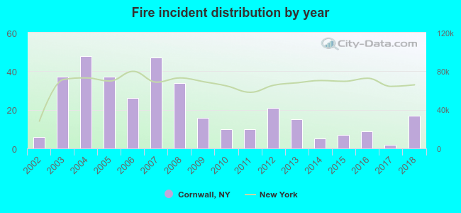 Based on the data from the years 2002 - 2018 the average number of fires per year is 20. The highest number of reported fires - 48 took place in 2004, and the least - 2 in 2017. The data has a growing trend.
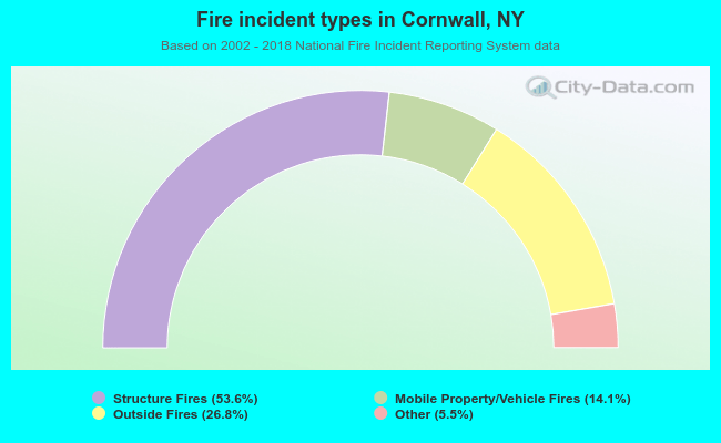 When looking into fire subcategories, the most reports belonged to: Structure Fires (53.6%), and Outside Fires (26.8%).
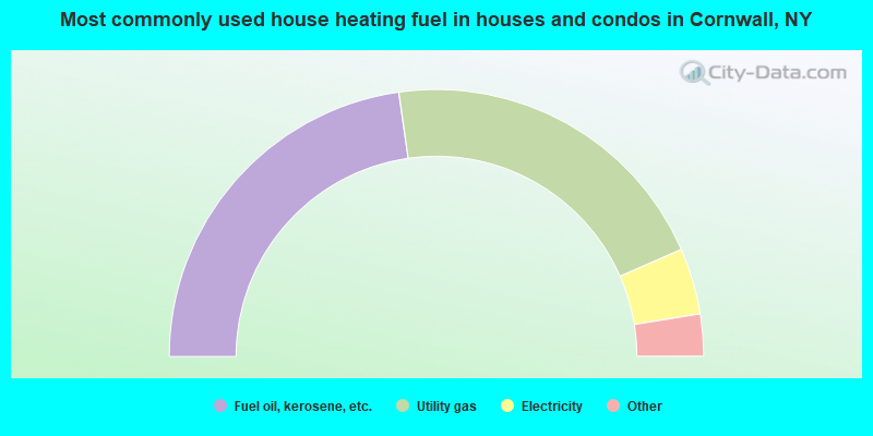
- 45.5%Fuel oil, kerosene, etc.
- 41.4%Utility gas
- 8.0%Electricity
- 2.9%Bottled, tank, or LP gas
- 1.3%Wood
- 0.5%Other fuel
- 0.4%Coal or coke
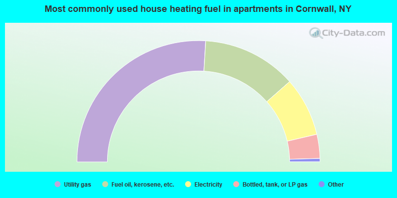
- 51.9%Utility gas
- 25.1%Fuel oil, kerosene, etc.
- 15.7%Electricity
- 6.4%Bottled, tank, or LP gas
- 0.4%Other fuel
- 0.4%No fuel used
Cornwall compared to New York state average:
- Unemployed percentage significantly below state average.
- Black race population percentage significantly below state average.
- Hispanic race population percentage below state average.
- Foreign-born population percentage significantly below state average.
- Renting percentage below state average.
- Length of stay since moving in significantly above state average.
- Number of rooms per house significantly below state average.
- House age significantly below state average.
Cornwall on our top lists:
- #20 on the list of "Top 101 cities with largest percentage of males in occupations: secondary school teachers (population 5,000+)"
- #27 on the list of "Top 101 cities with largest percentage of males in occupations: preschool, kindergarten, elementary and middle school teachers (population 5,000+)"
- #30 on the list of "Top 101 cities with largest percentage of females in industries: clothing and accessories, including shoe, stores (population 5,000+)"
- #41 on the list of "Top 101 cities with largest percentage of males in occupations: architects, surveyors, and cartographers (population 5,000+)"
- #44 on the list of "Top 101 cities with largest percentage of males in industries: religious, grantmaking, civic, professional, and similar organizations (population 5,000+)"
- #45 on the list of "Top 101 cities with largest percentage of males in occupations: librarians, curators, and archivists (population 5,000+)"
- #51 on the list of "Top 101 cities with largest percentage of males in industries: motor vehicles, parts and supplies merchant wholesalers (population 5,000+)"
- #59 on the list of "Top 101 cities with largest percentage of females in industries: petroleum and coal products (population 5,000+)"
- #60 on the list of "Top 101 cities with largest percentage of females in occupations: rail and water transportation workers (population 5,000+)"
- #64 on the list of "Top 101 cities with largest percentage of females in industries: electrical and electronic goods merchant wholesalers (population 5,000+)"
- #101 on the list of "Top 101 cities with largest percentage of males in occupations: entertainers and performers, sports, and related workers (population 5,000+)"
- #5 on the list of "Top 101 counties with the largest increase in the number of infant deaths per 1000 residents 2000-2006 to 2007-2013 (pop. 50,000+)"
- #21 on the list of "Top 101 counties with the lowest Ozone (1-hour) air pollution readings in 2012 (ppm)"
- #67 on the list of "Top 101 counties with the largest number of people moving out compared to moving in (pop. 50,000+)"
- #79 on the list of "Top 101 counties with the most Catholic congregations"
- #90 on the list of "Top 101 counties with the most Other adherents (pop. 50,000+)"

|
|
Total of 96 patent applications in 2008-2024.