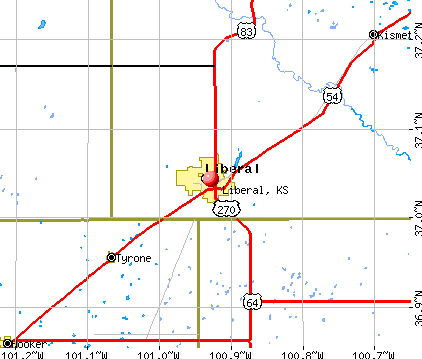
Liberal, Kansas
Liberal: Restored Depot & Hotel, now Chamber of Commerce & VA Clinic
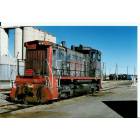
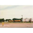
Liberal: SP2494 S-12 Note Red Lettering Liberal Yards, Liberal, KS
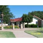
Liberal: Coronado statue near Dorothy & Toto's house
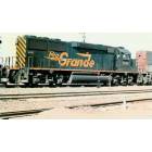
Liberal: DRGW3155 GP-60 in Liberal Yards, Liberal, KS
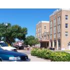
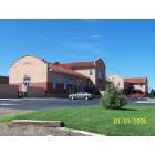
Liberal: Landmark building downtown
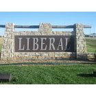
Liberal: Welcome to Liberal
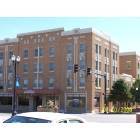
Liberal: Landmark building on 3rd St. Downtown Liberal
Liberal: Heading Westbound from downtown Liberal.
- add
your
Submit your own pictures of this city and show them to the world
- OSM Map
- General Map
- Google Map
- MSN Map
Population change since 2000: -2.0%
 |
| Males: 10,015 | |
| Females: 9,259 |
| Median resident age: | 30.8 years |
| Kansas median age: | 37.6 years |
Zip codes: 67901.
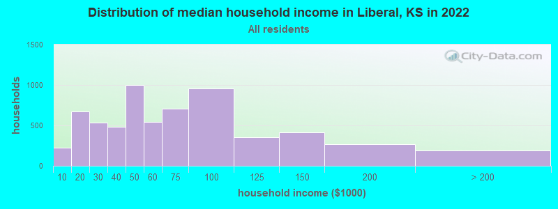
| Liberal: | $54,947 |
| KS: | $68,925 |
Estimated per capita income in 2022: $24,954 (it was $15,108 in 2000)
Liberal city income, earnings, and wages data
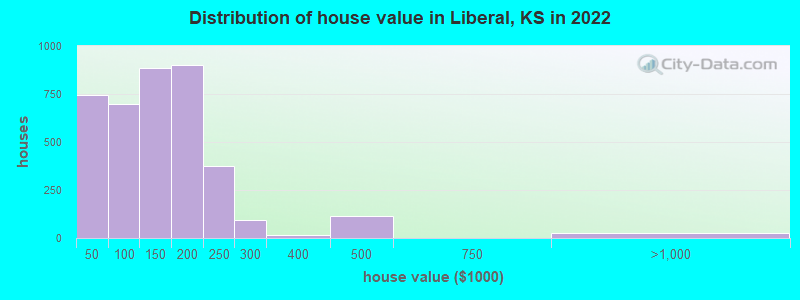
Estimated median house or condo value in 2022: $140,680 (it was $65,400 in 2000)
| Liberal: | $140,680 |
| KS: | $206,600 |
Mean prices in 2022: all housing units: $158,570; detached houses: $182,511; townhouses or other attached units: $138,462; in 3-to-4-unit structures: $108,908; mobile homes: $29,639
Median gross rent in 2022: $815.
(15.9% for White Non-Hispanic residents, 11.3% for Black residents, 14.8% for Hispanic or Latino residents, 10.7% for American Indian residents, 18.0% for other race residents, 9.2% for two or more races residents)
Detailed information about poverty and poor residents in Liberal, KS
Compare current foreclosures near Liberal, KS:
| Photo | Address | Area | Beds / Baths | Price | Details |
|---|---|---|---|---|---|

|
#1
Mccray Blvd
Liberal, KS 67901
|
1,161 sq. feet
|
2 baths 3 beds |
show details | |

|
#2
Mission Blvd
Liberal, KS 67901
|
1,118 sq. feet
|
2 baths 3 beds |
show details | |

|
#3
Cornell Ave
Liberal, KS 67901
|
1,128 sq. feet
|
1 baths 3 beds |
show details | |

|
#4
S Clay Ave
Liberal, KS 67901
|
1,135 sq. feet
|
1 baths 4 beds |
show details | |

|
#5
N Countryside Dr
Liberal, KS 67901
|
- sq. feet
|
- baths - beds |
show details | |

|
#6
Warren Ave
Liberal, KS 67901
|
- sq. feet
|
- baths - beds |
show details | |

|
#7
S Pershing Ave
Liberal, KS 67901
|
- sq. feet
|
- baths - beds |
show details | |

|
#8
Don St
Kismet, KS 67859
|
1,422 sq. feet
|
3 baths 3 beds |
show details | |

|
Check over 1 million property listings on Foreclosure.com!
|
browse all offers | |||


- 13,05168.3%Hispanic
- 4,74324.8%White alone
- 6073.2%Black alone
- 5953.1%Two or more races
- 4952.6%Asian alone
- 30.02%American Indian alone
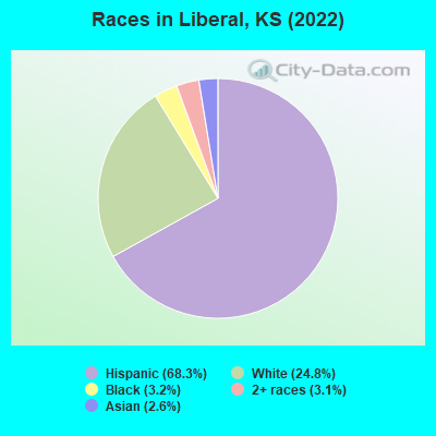
Races in Liberal detailed stats: ancestries, foreign born residents, place of birth
According to our research of Kansas and other state lists, there were 58 registered sex offenders living in Liberal, Kansas as of April 28, 2024.
The ratio of all residents to sex offenders in Liberal is 358 to 1.
The ratio of registered sex offenders to all residents in this city is lower than the state average.
Type |
2009 |
2010 |
2011 |
2012 |
2013 |
2014 |
2015 |
2016 |
2017 |
2018 |
2019 |
2020 |
2021 |
2022 |
|---|---|---|---|---|---|---|---|---|---|---|---|---|---|---|
| Murders (per 100,000) | 0 (0.0) | 2 (9.7) | 1 (4.8) | 0 (0.0) | 0 (0.0) | 1 (4.7) | 1 (4.7) | 3 (14.4) | 1 (4.9) | 1 (5.1) | 0 (0.0) | 0 (0.0) | 0 (0.0) | 0 (0.0) |
| Rapes (per 100,000) | 4 (19.9) | 6 (29.2) | 7 (33.9) | 10 (47.7) | 13 (61.1) | 20 (95.0) | 12 (56.8) | 11 (52.9) | 6 (29.5) | 9 (45.6) | 6 (31.0) | 6 (31.5) | 36 (192.9) | 7 (35.8) |
| Robberies (per 100,000) | 11 (54.7) | 11 (53.6) | 5 (24.2) | 7 (33.4) | 6 (28.2) | 8 (38.0) | 4 (18.9) | 6 (28.9) | 4 (19.7) | 9 (45.6) | 1 (5.2) | 2 (10.5) | 5 (26.8) | 7 (35.8) |
| Assaults (per 100,000) | 82 (407.6) | 73 (355.7) | 46 (222.7) | 52 (248.0) | 42 (197.5) | 52 (247.0) | 72 (340.8) | 25 (120.3) | 58 (285.5) | 48 (243.3) | 32 (165.2) | 4 (21.0) | 64 (343.0) | 57 (291.5) |
| Burglaries (per 100,000) | 113 (561.7) | 160 (779.5) | 136 (658.4) | 154 (734.5) | 114 (536.2) | 102 (484.5) | 80 (378.6) | 80 (384.9) | 73 (359.3) | 65 (329.5) | 18 (92.9) | 5 (26.3) | 43 (230.5) | 29 (148.3) |
| Thefts (per 100,000) | 356 (1,770) | 439 (2,139) | 369 (1,786) | 409 (1,951) | 373 (1,754) | 459 (2,180) | 434 (2,054) | 235 (1,131) | 214 (1,053) | 231 (1,171) | 92 (475.0) | 9 (47.3) | 190 (1,018) | 161 (823.2) |
| Auto thefts (per 100,000) | 22 (109.4) | 16 (78.0) | 12 (58.1) | 18 (85.8) | 19 (89.4) | 25 (118.7) | 27 (127.8) | 10 (48.1) | 16 (78.8) | 20 (101.4) | 8 (41.3) | 2 (10.5) | 18 (96.5) | 21 (107.4) |
| Arson (per 100,000) | 6 (29.8) | 3 (14.6) | 1 (4.8) | 0 (0.0) | 2 (9.4) | 6 (28.5) | 6 (28.4) | 3 (14.4) | 3 (14.8) | 2 (10.1) | 1 (5.2) | 0 (0.0) | 7 (37.5) | 0 (0.0) |
| City-Data.com crime index | 232.7 | 276.4 | 210.8 | 234.1 | 211.7 | 276.9 | 247.6 | 179.9 | 170.1 | 187.0 | 88.2 | 37.2 | 295.6 | 149.6 |
The City-Data.com crime index weighs serious crimes and violent crimes more heavily. Higher means more crime, U.S. average is 246.1. It adjusts for the number of visitors and daily workers commuting into cities.
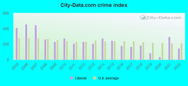
Crime rate in Liberal detailed stats: murders, rapes, robberies, assaults, burglaries, thefts, arson
Full-time law enforcement employees in 2021, including police officers: 44 (32 officers - 28 male; 4 female).
| Officers per 1,000 residents here: | 1.72 |
| Kansas average: | 2.70 |
 Recent articles from our blog. Our writers, many of them Ph.D. graduates or candidates, create easy-to-read articles on a wide variety of topics.

 | Did the Wizard of Oz take place in Liberal, KS (6 replies) |
| Kansas gubernatorial election, 2018 (26 candidates so far) (89 replies) |
| Tell me about Lawrence, (U of Kansas Music Therapy program) (7 replies) |
| Kansas Passes New Budget With Tax Increases (88 replies) |
| Kansas Job Losses (390 replies) |
| Garden City — Any tricks for finding a nice house to rent? (70 replies) |
Latest news from Liberal, KS collected exclusively by city-data.com from local newspapers, TV, and radio stations
Ancestries: American (4.7%), German (4.4%), English (2.4%), Irish (1.0%).
Current Local Time: CST time zone
Elevation: 2836 feet
Land area: 11.1 square miles.
Population density: 1,743 people per square mile (low).
5,694 residents are foreign born (26.5% Latin America).
| This city: | 29.8% |
| Kansas: | 7.1% |
Median real estate property taxes paid for housing units with mortgages in 2022: $2,680 (1.6%)
Median real estate property taxes paid for housing units with no mortgage in 2022: $1,838 (1.7%)
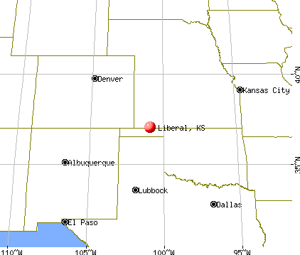
Nearest city with pop. 50,000+: Amarillo, TX  (137.5 miles , pop. 173,627).
Nearest city with pop. 200,000+: Wichita, KS (202.4 miles , pop. 344,284).
Nearest city with pop. 1,000,000+: Dallas, TX (375.8 miles , pop. 1,188,580).
Nearest cities:
), ), ), ), ), Latitude: 37.04 N, Longitude: 100.93 W
Daytime population change due to commuting: +790 (+4.1%)
Workers who live and work in this city: 7,665 (84.3%)
Area code: 620

Liberal tourist attractions:
Liberal, Kansas accommodation & food services, waste management - Economy and Business Data
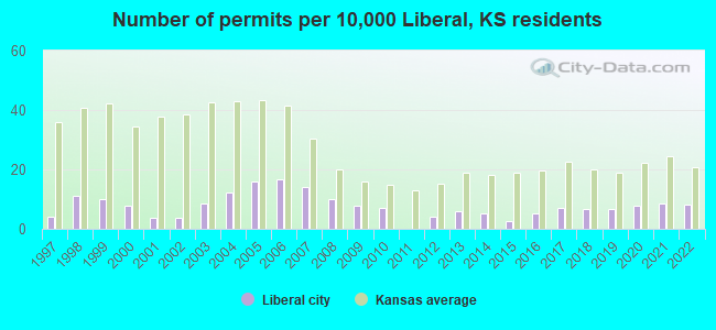
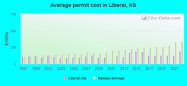
Single-family new house construction building permits:
- 2022: 16 buildings, average cost: $189,400
- 2021: 17 buildings, average cost: $127,600
- 2020: 15 buildings, average cost: $127,600
- 2019: 13 buildings, average cost: $127,600
- 2018: 13 buildings, average cost: $127,600
- 2017: 14 buildings, average cost: $127,600
- 2016: 10 buildings, average cost: $180,400
- 2015: 5 buildings, average cost: $196,300
- 2014: 10 buildings, average cost: $179,300
- 2013: 12 buildings, average cost: $110,000
- 2012: 8 buildings, average cost: $126,600
- 2010: 14 buildings, average cost: $104,300
- 2009: 15 buildings, average cost: $104,300
- 2008: 20 buildings, average cost: $130,200
- 2007: 28 buildings, average cost: $117,900
- 2006: 33 buildings, average cost: $100,500
- 2005: 31 buildings, average cost: $103,000
- 2004: 24 buildings, average cost: $99,100
- 2003: 17 buildings, average cost: $91,400
- 2002: 7 buildings, average cost: $111,100
- 2001: 7 buildings, average cost: $135,600
- 2000: 15 buildings, average cost: $102,900
- 1999: 20 buildings, average cost: $120,300
- 1998: 22 buildings, average cost: $123,100
- 1997: 8 buildings, average cost: $112,100
| Here: | 2.0% |
| Kansas: | 2.0% |
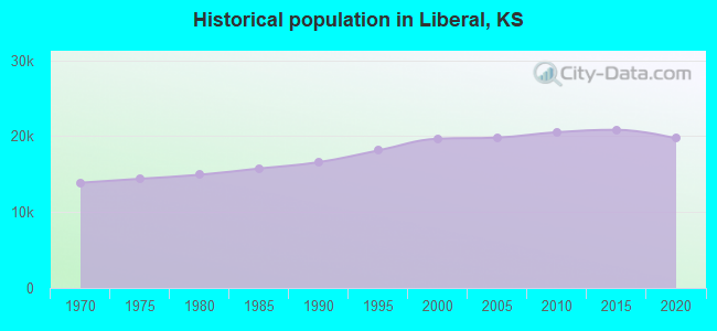
Population change in the 1990s: +3,196 (+19.4%).
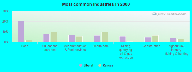
- Food (20.8%)
- Educational services (7.8%)
- Accommodation & food services (6.7%)
- Health care (6.5%)
- Mining, quarrying, oil & gas extraction (5.6%)
- Construction (4.7%)
- Agriculture, forestry, fishing & hunting (3.9%)
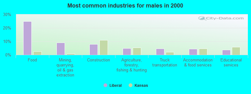
- Food (24.8%)
- Mining, quarrying, oil & gas extraction (9.0%)
- Construction (7.9%)
- Agriculture, forestry, fishing & hunting (5.0%)
- Truck transportation (4.6%)
- Accommodation & food services (4.5%)
- Educational services (3.7%)
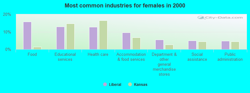
- Food (15.7%)
- Educational services (13.0%)
- Health care (12.7%)
- Accommodation & food services (9.5%)
- Department & other general merchandise stores (5.5%)
- Social assistance (5.0%)
- Public administration (4.7%)
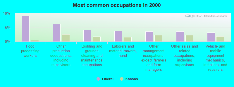
- Food processing workers (9.1%)
- Other production occupations, including supervisors (6.2%)
- Building and grounds cleaning and maintenance occupations (4.1%)
- Laborers and material movers, hand (3.8%)
- Other management occupations, except farmers and farm managers (3.6%)
- Other sales and related occupations, including supervisors (3.6%)
- Vehicle and mobile equipment mechanics, installers, and repairers (3.2%)
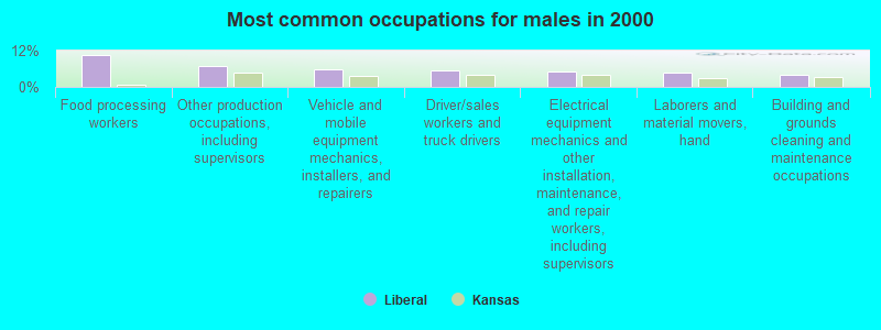
- Food processing workers (10.4%)
- Other production occupations, including supervisors (6.9%)
- Vehicle and mobile equipment mechanics, installers, and repairers (5.7%)
- Driver/sales workers and truck drivers (5.4%)
- Electrical equipment mechanics and other installation, maintenance, and repair workers, including supervisors (5.2%)
- Laborers and material movers, hand (4.7%)
- Building and grounds cleaning and maintenance occupations (4.0%)
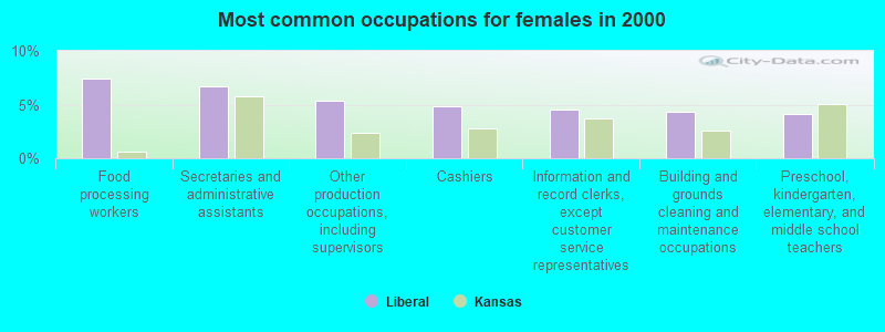
- Food processing workers (7.4%)
- Secretaries and administrative assistants (6.7%)
- Other production occupations, including supervisors (5.4%)
- Cashiers (4.8%)
- Information and record clerks, except customer service representatives (4.5%)
- Building and grounds cleaning and maintenance occupations (4.3%)
- Preschool, kindergarten, elementary, and middle school teachers (4.1%)
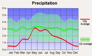
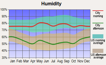
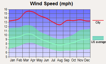
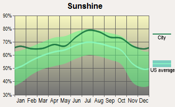
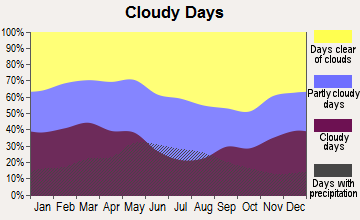
Average climate in Liberal, Kansas
Based on data reported by over 4,000 weather stations


|
|

Tornado activity:
Liberal-area historical tornado activity is slightly below Kansas state average. It is 39% greater than the overall U.S. average.
On 5/5/1993, a category F4 (max. wind speeds 207-260 mph) tornado 19.6 miles away from the Liberal city center caused between $500,000 and $5,000,000 in damages.
On 6/6/1951, a category F3 (max. wind speeds 158-206 mph) tornado 0.9 miles away from the city center injured 3 people and caused between $5000 and $50,000 in damages.
Earthquake activity:
Liberal-area historical earthquake activity is significantly above Kansas state average. It is 687% greater than the overall U.S. average.On 9/3/2016 at 12:02:44, a magnitude 5.8 (5.8 MW, Depth: 3.5 mi, Class: Moderate, Intensity: VI - VII) earthquake occurred 225.7 miles away from Liberal center
On 2/13/2016 at 17:07:06, a magnitude 5.1 (5.1 MW, Depth: 5.2 mi) earthquake occurred 128.8 miles away from Liberal center
On 11/6/2011 at 03:53:10, a magnitude 5.7 (5.7 MW, Depth: 3.2 mi) earthquake occurred 254.5 miles away from Liberal center
On 2/15/1974 at 13:33:49, a magnitude 4.6 (4.5 MB, 4.6 LG, Class: Light, Intensity: IV - V) earthquake occurred 39.8 miles away from Liberal center
On 8/23/2011 at 05:46:18, a magnitude 5.3 (5.3 MW, Depth: 2.5 mi) earthquake occurred 208.3 miles away from Liberal center
On 1/7/2016 at 04:27:57, a magnitude 4.7 (4.7 MW, Depth: 2.5 mi) earthquake occurred 127.8 miles away from Liberal center
Magnitude types: regional Lg-wave magnitude (LG), body-wave magnitude (MB), moment magnitude (MW)
Natural disasters:
The number of natural disasters in Seward County (10) is smaller than the US average (15).Major Disasters (Presidential) Declared: 5
Emergencies Declared: 2
Causes of natural disasters: Floods: 5, Storms: 4, Winter Storms: 4, Tornadoes: 3, Hurricane: 1, Snowstorm: 1, Wind: 1, Other: 1 (Note: some incidents may be assigned to more than one category).
Hospitals and medical centers in Liberal:
- SOUTHWEST HOMECARE HOSPICE (315 WEST 15TH PO BOX 1340)
- SOUTHWEST MEDICAL CENTER (Government - Local, 315 WEST 15TH STREET)
- GOOD SAMARITAN SOCIETY - LIBERAL (2160 ZINNIA LN)
- LIBERAL GOOD SAMARITAN CENTER (2160 ZINNIA LN)
- WHEATRIDGE PARK CARE CENTER (1501 S HOLLY DR)
- RENAL CARE GROUP - LIBERAL (2319 N KANSAS)
- LIBERAL HH AND GUYMON HOSPICE (502 NORTH KANSAS)
Airports located in Liberal:
- Liberal Mid-America Regional Airport (LBL) (Runways: 2, Commercial Ops: 10, Air Taxi Ops: 1,220, Itinerant Ops: 20,000, Local Ops: 20,000, Military Ops: 500)
College/University in Liberal:
Colleges/universities with over 2000 students nearest to Liberal:
- Amarillo College (about 139 miles; Amarillo, TX; Full-time enrollment: 6,622)
- Barton County Community College (about 153 miles; Great Bend, KS; FT enrollment: 4,108)
- West Texas A & M University (about 153 miles; Canyon, TX; FT enrollment: 6,820)
- Fort Hays State University (about 154 miles; Hays, KS; FT enrollment: 8,728)
- Southwestern Oklahoma State University (about 162 miles; Weatherford, OK; FT enrollment: 4,126)
- Hutchinson Community College (about 180 miles; Hutchinson, KS; FT enrollment: 4,174)
- Western Oklahoma State College (about 187 miles; Altus, OK; FT enrollment: 2,054)
Public high school in Liberal:
- LIBERAL SR HIGH (Students: 1,235, Location: 1611 W 2ND, Grades: 9-12)
Private high school in Liberal:
Biggest public elementary/middle schools in Liberal:
- COTTONWOOD INTERMEDIATE SCHOOL (Students: 498, Location: 1100 W. 11TH, Grades: 4-6)
- SUNFLOWER INTERMEDIATE SCHOOL (Students: 473, Location: 310 W. PINE, Grades: 4-6)
- LIBERAL SOUTH MIDDLE (Students: 349, Location: 950 S GRANT AVE, Grades: 7-8)
- LIBERAL WEST MIDDLE (Students: 339, Location: 500 N WESTERN, Grades: 7-8)
- SOUTHLAWN ELEM (Students: 314, Location: 836 S JORDAN, Grades: KG-3)
- WASHINGTON ELEM (Students: 314, Location: 840 N WASHINGTON, Grades: PK-3)
- MCDERMOTT ELEM (Students: 262, Location: 439 S PENNSYLVANIA, Grades: KG-3)
- MACARTHUR ELEM (Students: 190, Location: 925 S HOLLY, Grades: KG-3)
- LINCOLN ELEM (Location: 1002 W 11TH, Grades: KG-3)
- MCKINLEY ELEM (Location: 615 W 7TH, Grades: KG-3)
User-submitted facts and corrections:
- You don\'t List Turpin, OK as nearest town. It is only 12 miles from Liberal.
added by Dicehiggins
Points of interest:
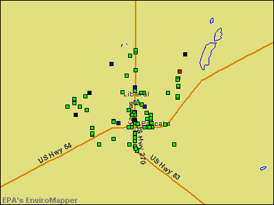
Notable locations in Liberal: Liberal Country Club (A), Liberal Wastewater Treatment Plant (B), Liberal Water Plant (C), Seward County Fairgrounds (D), Fairgrounds Speedway (E), Union Pacific Railroad Yard (F), Lowry Industrial Park (G), Sage Industrial Park (H), Village Plaza (I), Mid America Industrial Park (J), Willow Tree Golf Course (K), Liberal Municipal Court (L), KZQD - FM (Liberal) (M), Seward County Sheriff's Department (N), Liberal Police Department (O), Seward County Courthouse (P), Seward County Fire Department (Q), Liberal Fire Department Station 3 (R), Liberal Fire Department Station 1 (S), Seward County Sheriff's Department Jail (T). Display/hide their locations on the map
Shopping Centers: Southgate Mall (1), Western Shopping Center (2), Southgate Shopping Center (3), South Ideal Shopping Center (4), Randall Park Mall (5). Display/hide their locations on the map
Churches in Liberal include: Central Christian Church (A), Deliverance Power House Church of God in Christ (B), Iglesia de Cristo Maranatha Elim (C), Latter House Church (D), Risen Glory Church (E), Templo Puerta del Cielo Asambleas de Dios (F), Faith Tabernacle Church (G), Grant Street Church of Christ (H), Church For All Nations - Liberal (I). Display/hide their locations on the map
Cemetery: Liberal Cemetery (1). Display/hide its location on the map
Parks in Liberal include: Redskin Field (1), Bellaire Park (2), Mahuron Park (3), Country Club Acres Park (4), Tower Park (5), Southlawn Park (6), Cooper Park (7), Blue Bonnet Park (8), Harrison Circle Park (9). Display/hide their locations on the map
Tourist attractions: Baker Arts Center (Museums; 624 North Pershing Avenue), Coronado Museum-Dorothy'S House (567 East Cedar Street), Mid-America Air Museum (Cultural Attractions- Events- & Facilities; 2000 West Second Street), Chamber of Commerce (4 Rock Island Road), Tourist Information Center (220 East Pancake Boulevard), Liberal City - Convention & Tourism Information Center- Visitors Information Ce (Tours & Charters; 1 Yellow Brick Road).
Hotels: Kansan Motel (310 East Pancake Boulevard), Super 8 Liberal KS (747 East Pancake Boulevard), Best Western La Fonda Motel (229 West Pancake Boulevard), Motel 9 (230 West Pancake Boulevard), Tumbleweed Motel (488 East Pancake Boulevard), Liberal Inn Restaurant (603 East Pancake Boulevard), SLEEP INN (405 E Pancake Blvd), Branding Iron Club (603 East Pancake Boulevard), Holiday Inn Express Hotel & Suites (1550 North Lincoln Avenue).
Court: Seward County - District Court Clerk (415 North Washington Avenue).
Birthplace of: Jerame Tuman - 2005 NFL player (Pittsburgh Steelers, born: Mar 24, 1976), Melvin Sanders - Basketball player, Antonio Hanson - College basketball player (Tulsa Golden Hurricane), Martin Lewis (basketball) - Basketball player, Wayne Angell - Economist.
Drinking water stations with addresses in Liberal and their reported violations in the past:
LIBERAL, CITY OF (Population served: 21,084, Groundwater):Past health violations:Past monitoring violations:
- MCL, Monthly (TCR) - In FEB-2005, Contaminant: Coliform. Follow-up actions: St Public Notif requested (FEB-28-2005), St Violation/Reminder Notice (FEB-28-2005), St Public Notif received (APR-04-2005), St Compliance achieved (APR-30-2005)
- MCL, Acute (TCR) - In FEB-2005, Contaminant: Coliform. Follow-up actions: St Violation/Reminder Notice (FEB-28-2005), St Public Notif requested (FEB-28-2005), St Public Notif received (APR-04-2005), St Compliance achieved (APR-30-2005)
- Initial Tap Sampling for Pb and Cu - In JUL-01-1992, Contaminant: Lead and Copper Rule. Follow-up actions: St Compliance achieved (FEB-04-1993), St Intentional no-action (JUL-22-1993)
- One minor monitoring violation
Drinking water stations with addresses in Liberal that have no violations reported:
- WESTERN STAR RV RANCH (Population served: 25, Primary Water Source Type: Groundwater)
| This city: | 3.0 people |
| Kansas: | 2.5 people |
| This city: | 73.0% |
| Whole state: | 66.0% |
| This city: | 6.4% |
| Whole state: | 5.8% |
Likely homosexual households (counted as self-reported same-sex unmarried-partner households)
- Lesbian couples: 0.4% of all households
- Gay men: 0.2% of all households
People in group quarters in Liberal in 2010:
- 205 people in college/university student housing
- 128 people in local jails and other municipal confinement facilities
- 109 people in nursing facilities/skilled-nursing facilities
- 12 people in emergency and transitional shelters (with sleeping facilities) for people experiencing homelessness
- 9 people in residential treatment centers for adults
- 7 people in other noninstitutional facilities
- 6 people in group homes intended for adults
People in group quarters in Liberal in 2000:
- 156 people in nursing homes
- 143 people in college dormitories (includes college quarters off campus)
- 70 people in local jails and other confinement facilities (including police lockups)
- 30 people in other noninstitutional group quarters
- 11 people in homes or halfway houses for drug/alcohol abuse
- 4 people in other group homes
Banks with branches in Liberal (2011 data):
- The First National Bank of Liberal: Express Bank South Branch, The First National Bank Of Liberal, First National Bank Of Liberal - Exp, Wal-Mart In-Store Branch. Info updated 2009/03/31: Bank assets: $241.3 mil, Deposits: $211.9 mil, local headquarters, positive income, Agricultural Specialization, 5 total offices, Holding Company: Kansas Bank Corporation
- Bank of America, National Association: Liberal Branch at 300 North Kansas Street, branch established on 1914/05/14; Liberal North Branch at 1325 North Kansas, branch established on 1974/08/21. Info updated 2009/11/18: Bank assets: $1,451,969.3 mil, Deposits: $1,077,176.8 mil, headquarters in Charlotte, NC, positive income, 5782 total offices, Holding Company: Bank Of America Corporation
- The Community Bank: at 2320 North Kansas Avenue, branch established on 1998/04/06; Branch at 303 S. Kansas, branch established on 2004/07/19. Info updated 2010/10/07: Bank assets: $98.0 mil, Deposits: $87.6 mil, local headquarters, positive income, Commercial Lending Specialization, 2 total offices, Holding Company: Light Bancshares Corporation
- Sunflower Bank, National Association: Liberal Branch at 711 North Kansas Avenue, branch established on 1907/04/07. Info updated 2011/09/20: Bank assets: $1,733.8 mil, Deposits: $1,299.6 mil, headquarters in Salina, KS, positive income, Commercial Lending Specialization, 34 total offices, Holding Company: Sunflower Financial, Inc.
- The Bank of Beaver City: Liberal Branch Office Branch at 10 E Tucker Road, branch established on 2007/02/20. Info updated 2006/11/03: Bank assets: $138.4 mil, Deposits: $124.4 mil, headquarters in Beaver, OK, positive income, Commercial Lending Specialization, 4 total offices, Holding Company: Beaver Bancorp, Inc.
For population 15 years and over in Liberal:
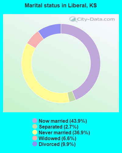
- Never married: 36.9%
- Now married: 43.9%
- Separated: 2.7%
- Widowed: 6.6%
- Divorced: 9.9%
For population 25 years and over in Liberal:
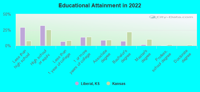
- High school or higher: 69.0%
- Bachelor's degree or higher: 9.4%
- Graduate or professional degree: 2.6%
- Unemployed: 5.2%
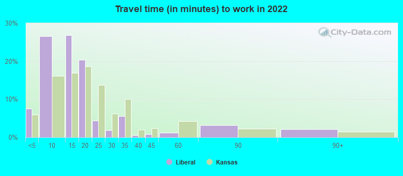
- Mean travel time to work (commute): 13.1 minutes
| Here: | 18.5 |
| Kansas average: | 11.5 |
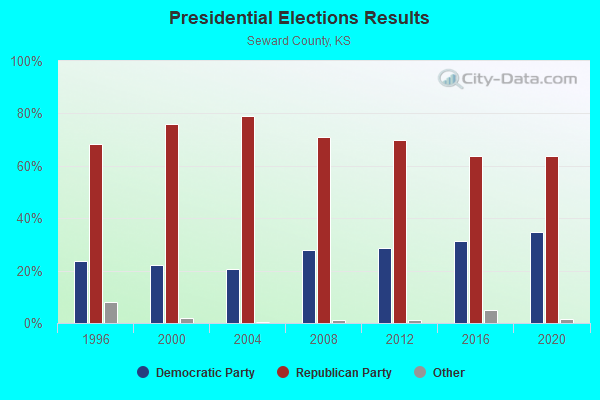
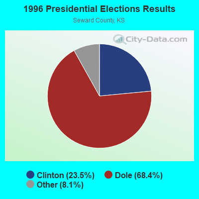
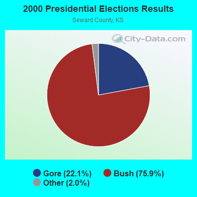
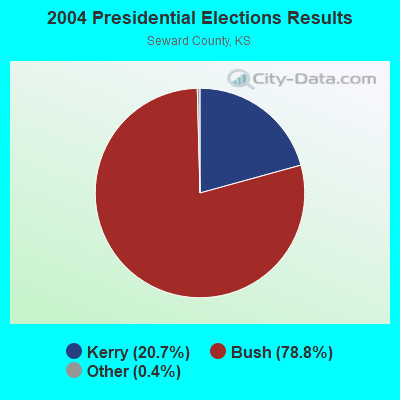

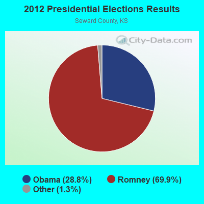
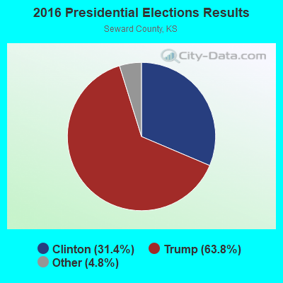
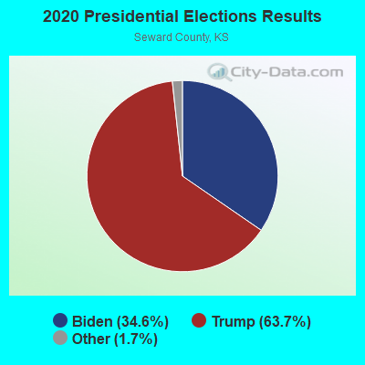
Graphs represent county-level data. Detailed 2008 Election Results
Religion statistics for Liberal, KS (based on Seward County data)
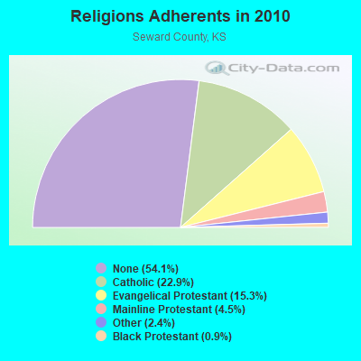
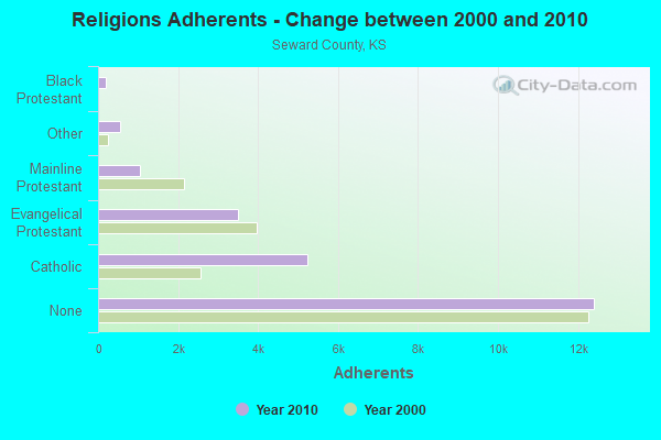
| Religion | Adherents | Congregations |
|---|---|---|
| Catholic | 5,246 | 1 |
| Evangelical Protestant | 3,512 | 29 |
| Mainline Protestant | 1,040 | 6 |
| Other | 542 | 3 |
| Black Protestant | 201 | 1 |
| None | 12,411 | - |
Food Environment Statistics:
| Here: | 0.87 / 10,000 pop. |
| Kansas: | 1.96 / 10,000 pop. |
| Seward County: | 0.44 / 10,000 pop. |
| Kansas: | 0.20 / 10,000 pop. |
| Seward County: | 5.24 / 10,000 pop. |
| State: | 3.84 / 10,000 pop. |
| Seward County: | 8.74 / 10,000 pop. |
| State: | 7.33 / 10,000 pop. |
| Seward County: | 7.1% |
| State: | 8.1% |
| Seward County: | 30.7% |
| Kansas: | 27.9% |
| Here: | 12.2% |
| Kansas: | 13.4% |
Health and Nutrition:
| Liberal: | 45.6% |
| State: | 49.2% |
| This city: | 43.9% |
| Kansas: | 46.3% |
| This city: | 28.3 |
| Kansas: | 28.6 |
| Here: | 23.9% |
| Kansas: | 21.2% |
| Liberal: | 10.1% |
| Kansas: | 10.5% |
| This city: | 6.8 |
| Kansas: | 6.8 |
| Here: | 30.1% |
| State: | 33.5% |
| Liberal: | 53.9% |
| State: | 56.0% |
| This city: | 80.2% |
| Kansas: | 78.6% |
More about Health and Nutrition of Liberal, KS Residents
| Local government employment and payroll (March 2022) | |||||
| Function | Full-time employees | Monthly full-time payroll | Average yearly full-time wage | Part-time employees | Monthly part-time payroll |
|---|---|---|---|---|---|
| Police Protection - Officers | 32 | $157,566 | $59,087 | 0 | $0 |
| Parks and Recreation | 30 | $107,380 | $42,952 | 24 | $10,830 |
| Other and Unallocable | 24 | $88,357 | $44,179 | 0 | $0 |
| Firefighters | 21 | $90,323 | $51,613 | 0 | $0 |
| Water Supply | 17 | $68,619 | $48,437 | 0 | $0 |
| Streets and Highways | 17 | $60,563 | $42,750 | 0 | $0 |
| Sewerage | 13 | $43,739 | $40,374 | 0 | $0 |
| Police - Other | 11 | $35,059 | $38,246 | 0 | $0 |
| Solid Waste Management | 10 | $39,359 | $47,231 | 0 | $0 |
| Judicial and Legal | 7 | $31,567 | $54,115 | 0 | $0 |
| Transit | 6 | $17,218 | $34,436 | 13 | $10,854 |
| Financial Administration | 6 | $39,268 | $78,536 | 1 | $1,229 |
| Other Government Administration | 6 | $39,224 | $78,448 | 0 | $0 |
| Health | 5 | $14,738 | $35,371 | 0 | $0 |
| Airports | 4 | $14,176 | $42,528 | 0 | $0 |
| Totals for Government | 209 | $847,155 | $48,640 | 38 | $22,913 |
Liberal government finances - Expenditure in 2021 (per resident):
- Construction - General - Other: $2,064,000 ($107.09)
- Current Operations - Regular Highways: $5,313,000 ($275.66)
General - Other: $4,433,000 ($230.00)
Police Protection: $3,678,000 ($190.83)
Parks and Recreation: $3,119,000 ($161.82)
Water Utilities: $2,867,000 ($148.75)
Sewerage: $2,285,000 ($118.55)
Central Staff Services: $2,122,000 ($110.10)
Solid Waste Management: $1,956,000 ($101.48)
Local Fire Protection: $1,432,000 ($74.30)
Housing and Community Development: $759,000 ($39.38)
Judicial and Legal Services: $744,000 ($38.60)
Protective Inspection and Regulation - Other: $694,000 ($36.01)
Libraries: $631,000 ($32.74)
Air Transportation: $481,000 ($24.96)
Health - Other: $268,000 ($13.90)
Miscellaneous Commercial Activities - Other: $147,000 ($7.63)
- General - Interest on Debt: $27,000 ($1.40)
- Other Capital Outlay - Sewerage: $3,913,000 ($203.02)
Air Transportation: $2,979,000 ($154.56)
General - Other: $1,299,000 ($67.40)
Parks and Recreation: $445,000 ($23.09)
Local Fire Protection: $290,000 ($15.05)
Water Utilities: $145,000 ($7.52)
Regular Highways: $57,000 ($2.96)
Solid Waste Management: $25,000 ($1.30)
- Total Salaries and Wages: $2,814,000 ($146.00)
- Water Utilities - Interest on Debt: $133,000 ($6.90)
Liberal government finances - Revenue in 2021 (per resident):
- Charges - Sewerage: $2,847,000 ($147.71)
Solid Waste Management: $1,743,000 ($90.43)
Parks and Recreation: $661,000 ($34.29)
Air Transportation: $250,000 ($12.97)
Other: $220,000 ($11.41)
Miscellaneous Commercial Activities: $36,000 ($1.87)
- Local Intergovernmental - General Local Government Support: $4,389,000 ($227.72)
- Miscellaneous - Fines and Forfeits: $735,000 ($38.13)
Donations From Private Sources: $307,000 ($15.93)
General Revenue - Other: $185,000 ($9.60)
Rents: $111,000 ($5.76)
Interest Earnings: $35,000 ($1.82)
Royalties: $14,000 ($0.73)
- Revenue - Water Utilities: $4,155,000 ($215.58)
- State Intergovernmental - Other: $7,526,000 ($390.47)
Highways: $2,439,000 ($126.54)
General Local Government Support: $389,000 ($20.18)
Health and Hospitals: $51,000 ($2.65)
Housing and Community Development: $35,000 ($1.82)
- Tax - Property: $7,788,000 ($404.07)
General Sales and Gross Receipts: $4,051,000 ($210.18)
Public Utilities Sales: $2,214,000 ($114.87)
Other License: $321,000 ($16.65)
Liberal government finances - Debt in 2021 (per resident):
- Long Term Debt - Beginning Outstanding - Unspecified Public Purpose: $3,045,000 ($157.98)
Outstanding Unspecified Public Purpose: $2,425,000 ($125.82)
Beginning Outstanding - Public Debt for Private Purpose: $1,505,000 ($78.08)
Outstanding Nonguaranteed - Industrial Revenue: $1,439,000 ($74.66)
Retired Unspecified Public Purpose: $620,000 ($32.17)
Retired Nonguaranteed - Public Debt for Private Purpose: $66,000 ($3.42)
Liberal government finances - Cash and Securities in 2021 (per resident):
- Bond Funds - Cash and Securities: $6,776,000 ($351.56)
- Other Funds - Cash and Securities: $22,534,000 ($1169.14)
- Sinking Funds - Cash and Securities: $2,431,000 ($126.13)
| Businesses in Liberal, KS | ||||
| Name | Count | Name | Count | |
|---|---|---|---|---|
| AT&T | 2 | Maurices | 1 | |
| Ace Hardware | 1 | McDonald's | 2 | |
| Applebee's | 1 | New Balance | 2 | |
| Arby's | 1 | Nike | 6 | |
| AutoZone | 1 | Payless | 1 | |
| Burger King | 1 | Pizza Hut | 3 | |
| Chevrolet | 1 | Quality | 1 | |
| ColorTyme | 1 | RadioShack | 1 | |
| Days Inn | 1 | Rodeway Inn | 1 | |
| FedEx | 5 | SONIC Drive-In | 1 | |
| Ford | 1 | Sears | 1 | |
| GNC | 1 | Subway | 2 | |
| GameStop | 1 | Super 8 | 1 | |
| H&R Block | 1 | Taco Bell | 1 | |
| Holiday Inn | 1 | The Room Place | 1 | |
| JCPenney | 1 | U-Haul | 1 | |
| KFC | 1 | UPS | 3 | |
| Kroger | 1 | Vans | 1 | |
| La-Z-Boy | 1 | Verizon Wireless | 1 | |
| Lane Furniture | 1 | Walmart | 1 | |
| Long John Silver's | 1 | Wendy's | 1 | |
| MasterBrand Cabinets | 1 | |||
Strongest AM radio stations in Liberal:
- KSCB (1270 AM; 5 kW; LIBERAL, KS; Owner: SEWARD COUNTY BROADCASTING CO., INC.)
- KYUU (1470 AM; 1 kW; LIBERAL, KS)
- KGYN (1210 AM; 50 kW; GUYMON, OK; Owner: TELNS BROADCASTING COMPANY, INC.)
- KICA (980 AM; 50 kW; CLOVIS, NM; Owner: BROADCAST ENTERTAINMENT CORPORATION)
- KGNC (710 AM; 10 kW; AMARILLO, TX; Owner: MCC RADIO, LLC)
- KRMG (740 AM; 50 kW; TULSA, OK; Owner: CXR HOLDINGS, INC.)
- KRVN (880 AM; 50 kW; LEXINGTON, NE; Owner: NEBRASKA RURAL RADIO ASSOCIATION)
- KLTT (670 AM; 50 kW; COMMERCE CITY, CO; Owner: KLZ RADIO, INC.)
- KGNO (1370 AM; 5 kW; DODGE CITY, KS; Owner: WAITT RADIO, INC.)
- KOA (850 AM; 50 kW; DENVER, CO; Owner: JACOR BROADCASTING OF COLORADO, INC.)
- KMUL (1380 AM; 50 kW; MULESHOE, TX; Owner: BROADCAST ENTERTAINMENT CORPORATION)
- KKOB (770 AM; 50 kW; ALBUQUERQUE, NM; Owner: CITADEL BROADCASTING COMPANY)
- KKZN (760 AM; 50 kW; THORNTON, CO; Owner: JACOR BROADCASTING OF COLORADO, INC.)
Strongest FM radio stations in Liberal:
- KZQD (105.1 FM; LIBERAL, KS; Owner: MARIO LOREDO)
- K242AK (96.3 FM; LIBERAL, KS; Owner: KANZA SOCIETY, INC.)
- KSLS (101.5 FM; LIBERAL, KS; Owner: WAITT RADIO, INC.)
- KLDG (102.7 FM; LIBERAL, KS; Owner: SEWARD COUNTY B/CASTING CO., INC.)
- KSCB-FM (107.5 FM; LIBERAL, KS; Owner: SEWARD COUNTY BROADCASTING CO., INC.)
- KJIL (99.1 FM; COPELAND, KS; Owner: GREAT PLAINS CHRISTIAN RADIO, INC.)
- KYBD (98.1 FM; COPELAND, KS; Owner: MAS COMMUNICATIONS, INC.)
- KHYM (103.9 FM; COPELAND, KS; Owner: GREAT PLAINS CHRISTIAN RADIO, INC.)
- National Bridge Inventory (NBI) Statistics
- 5Number of bridges
- 102ft / 30.8mTotal length
- 30,743Total average daily traffic
- 6,721Total average daily truck traffic
FCC Registered Antenna Towers: 178 (See the full list of FCC Registered Antenna Towers)
FCC Registered Commercial Land Mobile Towers: 3 (See the full list of FCC Registered Commercial Land Mobile Towers in Liberal, KS)
FCC Registered Private Land Mobile Towers: 3 (See the full list of FCC Registered Private Land Mobile Towers)
FCC Registered Broadcast Land Mobile Towers: 35 (See the full list of FCC Registered Broadcast Land Mobile Towers)
FCC Registered Microwave Towers: 60 (See the full list of FCC Registered Microwave Towers in this town)
FCC Registered Paging Towers: 11 (See the full list of FCC Registered Paging Towers)
FCC Registered Maritime Coast & Aviation Ground Towers: 9 (See the full list of FCC Registered Maritime Coast & Aviation Ground Towers)
FCC Registered Amateur Radio Licenses: 43 (See the full list of FCC Registered Amateur Radio Licenses in Liberal)
FAA Registered Aircraft Manufacturers and Dealers: 9 (See the full list of FAA Registered Manufacturers and Dealers in Liberal)
FAA Registered Aircraft: 75 (See the full list of FAA Registered Aircraft)
2002 - 2018 National Fire Incident Reporting System (NFIRS) incidents
- Fire incident types reported to NFIRS in Liberal, KS
- 1,22851.9%Outside Fires
- 75031.7%Structure Fires
- 36115.3%Mobile Property/Vehicle Fires
- 261.1%Other
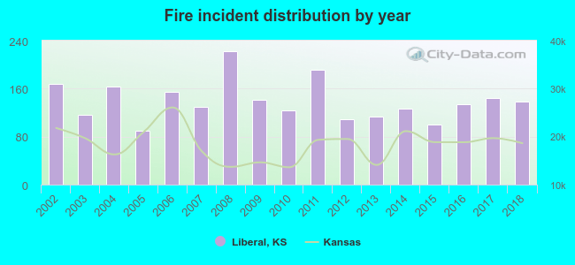 Based on the data from the years 2002 - 2018 the average number of fire incidents per year is 139. The highest number of fires - 222 took place in 2008, and the least - 90 in 2005. The data has a declining trend.
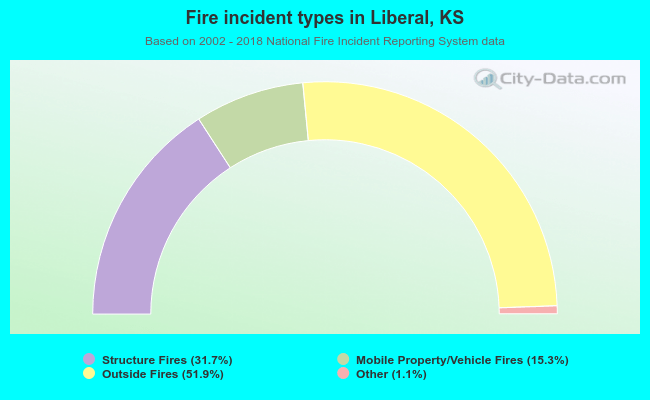 When looking into fire subcategories, the most reports belonged to: Outside Fires (51.9%), and Structure Fires (31.7%).
Fire-safe hotels and motels in Liberal, Kansas:
- Days Inn Liberal, 405 E Pancake, Liberal, Kansas 67901 , Phone: (620) 624-7377, Fax: (620) 626-7887
- Rodeway Inn, 488 E Pancake Blvd, Liberal, Kansas 67901 , Phone: (620) 624-5642, Fax: (620) 624-5642
- Quality Inn, 720 E Pancake Blvd, Liberal, Kansas 67901 , Phone: (620) 624-0242, Fax: (620) 624-1952
- Americas Best Value Inn, 564 E Pancake Blvd, Liberal, Kansas 67901 , Phone: (620) 624-6203, Fax: (620) 626-4940
- Hampton Inn & Suites, 508 Hotel Dr, Liberal, Kansas 67901 , Phone: (620) 604-0699, Fax: (620) 604-0704
- Comfort Suites, 2891 Centennial Blvd, Liberal, Kansas 67901 , Phone: (620) 626-5439, Fax: (620) 417-7374
| Most common first names in Liberal, KS among deceased individuals | ||
| Name | Count | Lived (average) |
|---|---|---|
| Mary | 76 | 80.1 years |
| William | 73 | 74.5 years |
| John | 66 | 74.0 years |
| Robert | 62 | 70.7 years |
| James | 59 | 68.7 years |
| Charles | 45 | 73.8 years |
| George | 41 | 74.7 years |
| Dorothy | 30 | 77.1 years |
| Mildred | 28 | 81.5 years |
| Harold | 26 | 74.2 years |
| Most common last names in Liberal, KS among deceased individuals | ||
| Last name | Count | Lived (average) |
|---|---|---|
| Smith | 57 | 79.3 years |
| Jones | 42 | 72.0 years |
| Johnson | 34 | 71.9 years |
| Davis | 33 | 75.8 years |
| Miller | 29 | 73.9 years |
| Williams | 28 | 75.6 years |
| Brown | 22 | 78.0 years |
| King | 19 | 77.7 years |
| White | 18 | 74.3 years |
| Scott | 18 | 72.7 years |
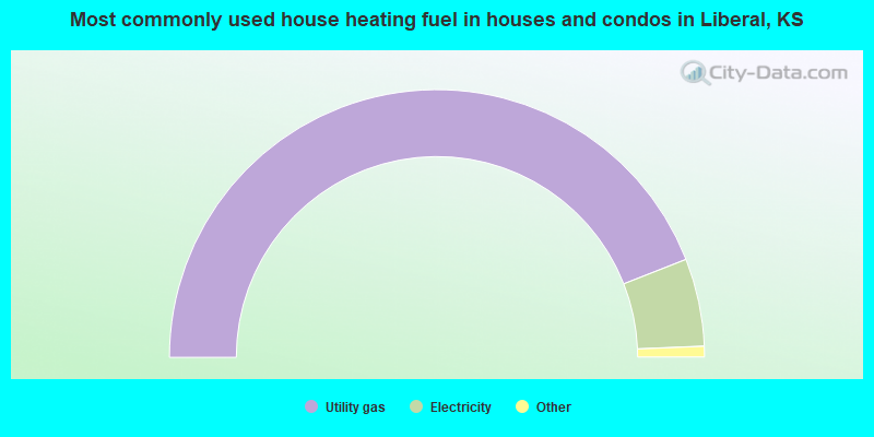
- 88.1%Utility gas
- 10.6%Electricity
- 0.8%Bottled, tank, or LP gas
- 0.4%Wood
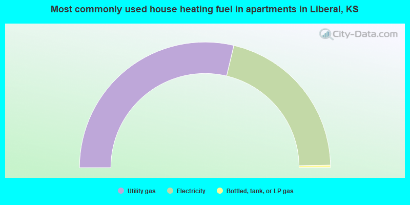
- 57.4%Utility gas
- 42.0%Electricity
- 0.6%Bottled, tank, or LP gas
Liberal compared to Kansas state average:
- Unemployed percentage below state average.
- Hispanic race population percentage significantly above state average.
- Median age below state average.
- Foreign-born population percentage significantly above state average.
- Length of stay since moving in significantly above state average.
- Percentage of population with a bachelor's degree or higher significantly below state average.
Liberal on our top lists:
- #20 on the list of "Top 101 cities with largest percentage of females in industries: manufacturing (population 5,000+)"
- #33 on the list of "Top 101 cities with largest percentage of females in occupations: production occupations (population 5,000+)"
- #68 on the list of "Top 101 cities with largest percentage of males in occupations: material moving occupations (population 5,000+)"
- #98 on the list of "Top 100 cities with lowest ratio of median house value to median household income (pop. 5,000+)"

|
Total of 4 patent applications in 2008-2024.