Welcome to City-Data.com Forum!
U.S. CitiesCity-Data Forum Index
Go Back   City-Data Forum > General Forums > Weather > Tornadoes
 [Register]
Please register to participate in our discussions with 2 million other members - it's free and quick! Some forums can only be seen by registered members. After you create your account, you'll be able to customize options and access all our 15,000 new posts/day with fewer ads.
View detailed profile (Advanced) or search
site with Google Custom Search

Search Forums  (Advanced)
Reply Start New Thread
 
Old 04-14-2012, 05:00 PM
 
Location: Wichita, KS
733 posts, read 1,756,878 times
Reputation: 1322

Advertisements

Quote:
Originally Posted by Cambium View Post
Trooper just said a lot of debris and he's stoping cars now. TWC showing large wedge.
Yep, they just said they've got a debris ball showing up on the radar.
Reply With Quote Quick reply to this message

 
Old 04-14-2012, 07:59 PM
 
Location: Near the Coast SWCT
83,540 posts, read 75,373,979 times
Reputation: 16634
  • A strong storm entered the U.S.
  • Warm, humid air surging northward from the Gulf of Mexico.
  • A powerful jet stream in the area to increase the intensity of the storms, and to produce wind shear.
Reply With Quote Quick reply to this message
 
Old 04-14-2012, 08:42 PM
 
Location: Near the Coast SWCT
83,540 posts, read 75,373,979 times
Reputation: 16634
The Storm nearing the Major City of Witchita KS has a tonado on it, it's almost ONE MILE WIDE....and the sun has gone down.
Reply With Quote Quick reply to this message
 
Old 04-14-2012, 08:48 PM
 
Location: Near the Coast SWCT
83,540 posts, read 75,373,979 times
Reputation: 16634
sumner ks-
936 pm cdt sat apr 14 2012

...a tornado warning remains in effect for northern sumner county until 1000 pm cdt...

...tornado emergency for conway springs...

At 932 pm cdt...a confirmed large...violent and extremely dangerous tornado was located 5 miles southwest of conway springs...and moving northeast at 35 mph.

This is a particularly dangerous situation.

Hazard...deadly tornado.

Source...spotter confirmed tornado.

impact...this is a life threatening situation. You could be killed if not underground or in a tornado shelter. Complete
destruction of entire neighborhoods is likely. Many well
built homes and businesses will be completely swept from
their foundations. Debris will block most roadways. Mass
devastation is highly likely making the area unrecognizable
to survivors.

locations impacted include... Wellington...conway springs...belle plaine...wellington airport and riverdale.


Tornadoes are difficult to see and confirm at night. Take cover now
Reply With Quote Quick reply to this message
 
Old 04-14-2012, 08:55 PM
 
Location: Near the Coast SWCT
83,540 posts, read 75,373,979 times
Reputation: 16634
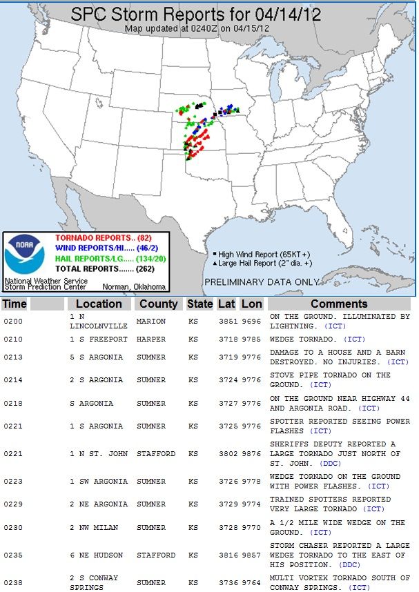
Over 80 reports. I cant imagine hearing the reports come in during the darkness. What they are going through. Sumner going through hell right now. 1/2 mile to 1 mile wide Tornado in the dark. Powerflashes seen

Reply With Quote Quick reply to this message
 
Old 04-14-2012, 08:57 PM
 
Location: Near the Coast SWCT
83,540 posts, read 75,373,979 times
Reputation: 16634
Everytime I refresh the page the report numbers go up. http://www.spc.noaa.gov/climo/reports/120414_rpts.html

MILE WIDE TORNADO ON GROUND near Witchita.
Reply With Quote Quick reply to this message
 
Old 04-14-2012, 09:04 PM
 
Location: Wichita, KS
733 posts, read 1,756,878 times
Reputation: 1322
People there in Wichita need to take cover! The radar shows a very good notch which usually signifies a tornado.
Reply With Quote Quick reply to this message
 
Old 04-14-2012, 09:22 PM
 
Location: Wichita, KS
733 posts, read 1,756,878 times
Reputation: 1322
Just in...large wedge tornado report near Wichita between Haysville and Oaklawn.
Reply With Quote Quick reply to this message
 
Old 04-14-2012, 09:47 PM
 
Location: Wichita, KS
733 posts, read 1,756,878 times
Reputation: 1322
That's a definite supercell storm...Southwest of El Dorado, KS.
Attached Thumbnails
April 2012 U.S Tornado Outbreak-map.png  
Reply With Quote Quick reply to this message
 
Old 04-15-2012, 01:22 AM
 
Location: Stillwater, Oklahoma
30,976 posts, read 21,650,795 times
Reputation: 9676
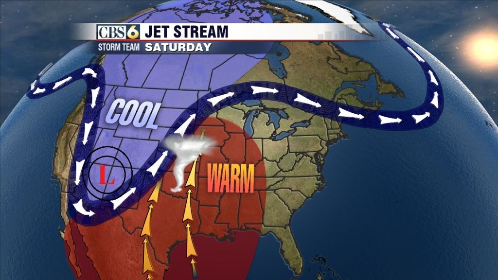
The squall line currently moving through western Oklahoma is currently not causing much trouble, fortunately, even though there is a tornado watch ahead of it. A TV weatherman described the storms as on the low end of the severe spectrum. The storms will arrive to Oklahoma City around 3:30am. It's a different story in Woodward, OK, where earlier a tornado came through, not directly associated with the squall line, and initial reports indicate two people were killed.
Reply With Quote Quick reply to this message
Please register to post and access all features of our very popular forum. It is free and quick. Over $68,000 in prizes has already been given out to active posters on our forum. Additional giveaways are planned.

Detailed information about all U.S. cities, counties, and zip codes on our site: City-data.com.


Reply
Please update this thread with any new information or opinions. This open thread is still read by thousands of people, so we encourage all additional points of view.

Quick Reply
Message:

Over $104,000 in prizes was already given out to active posters on our forum and additional giveaways are planned!

Go Back   City-Data Forum > General Forums > Weather > Tornadoes
Similar Threads

All times are GMT -6.

© 2005-2024, Advameg, Inc. · Please obey Forum Rules · Terms of Use and Privacy Policy · Bug Bounty

City-Data.com - Contact Us - Archive 1, 2, 3, 4, 5, 6, 7, 8, 9, 10, 11, 12, 13, 14, 15, 16, 17, 18, 19, 20, 21, 22, 23, 24, 25, 26, 27, 28, 29, 30, 31, 32, 33, 34, 35, 36, 37 - Top