Bridge Statistics for Joliet, Illinois (IL)
Condition, Traffic, Stress, Structural Evaluation, Project Costs
- National Bridge Inventory (NBI) Statistics
- 184Number of bridges
- 2,356ft / 718mTotal length
- $55,737,000Total costs
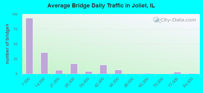
- 2,431,210Total average daily traffic
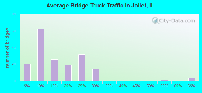
- 444,312Total average daily truck traffic
- National Bridge Inventory (NBI) Registered Bridges for Joliet
- No street view available for this location
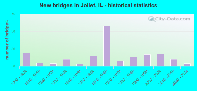
- New bridges - historical statistics
- 191900-1909
- 51910-1919
- 41920-1929
- 101930-1939
- 31940-1949
- 151950-1959
- 581960-1969
- 81970-1979
- 131980-1989
- 171990-1999
- 182000-2009
- 102010-2019
- 42020-2022
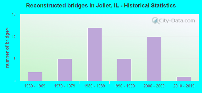
- Reconstructed bridges - Historical Statistics
- 21960-1969
- 51970-1979
- 121980-1989
- 51990-1999
- 102000-2009
- 12010-2019
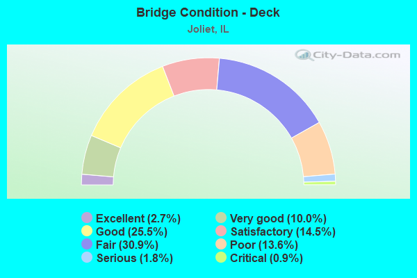
- Bridge Condition - Deck
- 2.7%Excellent
- 10.0%Very good
- 25.5%Good
- 14.5%Satisfactory
- 30.9%Fair
- 13.6%Poor
- 1.8%Serious
- 0.9%Critical
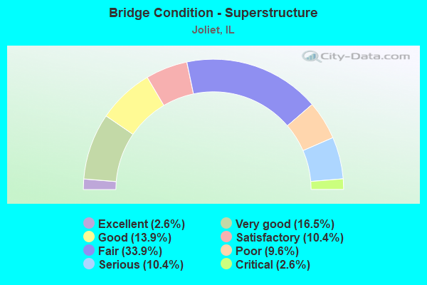
- Bridge Condition - Superstructure
- 2.6%Excellent
- 16.5%Very good
- 13.9%Good
- 10.4%Satisfactory
- 33.9%Fair
- 9.6%Poor
- 10.4%Serious
- 2.6%Critical
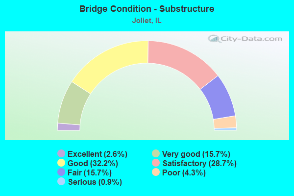
- Bridge Condition - Substructure
- 2.6%Excellent
- 15.7%Very good
- 32.2%Good
- 28.7%Satisfactory
- 15.7%Fair
- 4.3%Poor
- 0.9%Serious
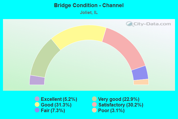
- Bridge Condition - Channel
- 5.2%Excellent
- 22.9%Very good
- 31.3%Good
- 30.2%Satisfactory
- 7.3%Fair
- 3.1%Poor
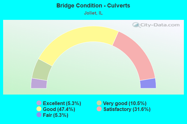
- Bridge Condition - Culverts
- 5.3%Excellent
- 10.5%Very good
- 47.4%Good
- 31.6%Satisfactory
- 5.3%Fair
Find on map >> Show street view
Structure Number: 99306, Location: Just E. of Il Rt. 53 (Lat: 41.429969, Lng: -88.077892), Route carried "on" structure: Other road , Year Built: 2013, Status: Open, Structure Length: 2.23m (7.32ft), Average Daily Traffic: 3,750 (year 2019), Truck Traffic: 8%, Average Future Daily Traffic: 4,291 (year 2032), Design Load: HS 25 or greater, Features Intersected: Jackson Creek, Facility Carried by Structure: Manhattan-Arsenal
Minimum Vertical Clearance: 30+ m (98+ ft), Kilometerpoint: 10.026, Lanes on structure: 2, Owner: County Highway Agency, Approaching Roadway Width: 13.4m (44.0ft), Material/Design: Steel, Design/Construction: Stringer/Multi-beam, Number Of Spans In Main Unit: 1, Length of Maximum Span: 21.3m (69.9ft), Curb-To-Curb Width: 13.4m (44.0ft), Out-to-Out Width: 14.4m (47.2ft)
Condition: Deck: Very good, Superstructure: Very good, Substructure: Very good, Channel: Excellent, Operating Rating: 42.1 metric tons, Method Used To Determine Operating Rating: Assigned ratings based on Load and Resistance Factor Design (LRFD) reported by rating factor (RF) using HL93 loadings, Inventory Rating: 32.4 metric tons, Method Used To Determine Inventory Rating: Assigned ratings based on Load and Resistance Factor Design (LRFD) reported by rating factor (RF) using HL93 loadings, Structural Evaluation: Equal to present desirable criteria, Deck Geometry: Better than present minimum criteria, Waterway Adequacy: Superior to present desirable criteria, Approach Roadway Alignment: Equal to present desirable criteria, Designated Inspection Frequency: Every 48 months, Inspection Date: April 2019, Deck Structure Type: Concrete Cast-file-Place, Wearing Surface/Protective System: Deck Protection: Epoxy Coated Reinforcing
Find on map >> Show street view
Structure Number: 993151, Location: 2.4 MI E ILL 53 (Lat: 41.459861, Lng: -88.032858), Route carried "on" structure: Other road , Year Built: 1900, Year Reconstructed: 1986, Status: Open, Structure Length: 1.55m (5.09ft), Average Daily Traffic: 20 (year 2016), Average Future Daily Traffic: 67 (year 2032), Features Intersected: JACKSON BRANCH, Facility Carried by Structure: BERNHARD ROAD
Minimum Vertical Clearance: 30+ m (98+ ft), Kilometerpoint: 2.301, Lanes on structure: 1, Owner: City or Municipal Highway Agency, Approaching Roadway Width: 3.7m (12.1ft), Material/Design: Prestressed concrete, Design/Construction: Box Beam or Girders - Multiple, Number Of Spans In Main Unit: 1, Length of Maximum Span: 15.5m (50.9ft), Curb-To-Curb Width: 5.5m (18.0ft), Out-to-Out Width: 5.5m (18.0ft)
Condition: Deck: Fair, Superstructure: Fair, Substructure: Good, Channel: Satisfactory, Operating Rating: 40.5 metric tons, Method Used To Determine Operating Rating: Field evaluation and documented engineering judgment, Inventory Rating: 24.3 metric tons, Method Used To Determine Inventory Rating: Field evaluation and documented engineering judgment, Structural Evaluation: Somewhat better than minimum adequacy, Deck Geometry: Meets minimum limits, Waterway Adequacy: Equal to present minimum criteria, Approach Roadway Alignment: Equal to present desirable criteria, Designated Inspection Frequency: Every 24 months, Inspection Date: June 2020, Deck Structure Type: Concrete Precast Panels
Find on map >> Show street view
Structure Number: 993181, Location: 0.6 MI S of US 52 (Lat: 41.465950, Lng: -88.022039), Route carried "on" structure: Other road , Year Built: 2021, Status: Open, Structure Length: 2.17m (7.12ft), Average Daily Traffic: 775 (year 2016), Truck Traffic: 3%, Average Future Daily Traffic: 1,150 (year 2043), Design Load: HS 25 or greater, Features Intersected: Jackson Branch, Facility Carried by Structure: Cherry Hill Rd
Minimum Vertical Clearance: 30+ m (98+ ft), Kilometerpoint: 0.966, Lanes on structure: 2, Owner: Town or Township Highway Agency, Approaching Roadway Width: 9.1m (29.9ft), Material/Design: Prestressed concrete, Design/Construction: Box Beam or Girders - Multiple, Number Of Spans In Main Unit: 1, Length of Maximum Span: 0.0m, Curb-To-Curb Width: 9.1m (29.9ft), Out-to-Out Width: 9.1m (29.9ft)
Condition: Deck: Excellent, Superstructure: Excellent, Substructure: Excellent, Channel: Excellent, Operating Rating: 47.0 metric tons, Method Used To Determine Operating Rating: Load and Resistance Factor Rating (LRFR) rating reported by rating factor(RF) method using HL-93 loadings, Inventory Rating: 37.3 metric tons, Method Used To Determine Inventory Rating: Load and Resistance Factor Rating (LRFR) rating reported by rating factor(RF) method using HL-93 loadings, Structural Evaluation: Superior to present desirable criteria, Deck Geometry: Equal to present minimum criteria, Waterway Adequacy: Superior to present desirable criteria, Approach Roadway Alignment: Equal to present desirable criteria, Designated Inspection Frequency: Every 24 months, Inspection Date: July 2021, Deck Structure Type: Concrete Precast Panels, Wearing Surface/Protective System: Wearing Surface: Bituminous, Membrane: Built-up
Find on map >> Show street view
Structure Number: 993184, Location: 0.6M N.MAN-ELWOOD RD (Lat: 41.440342, Lng: -88.021217), Route carried "on" structure: Other road , Year Built: 1900, Status: Open, Structure Length: 1.49m (4.89ft), Average Daily Traffic: 775 (year 2016), Truck Traffic: 3%, Average Future Daily Traffic: 134 (year 2032), Features Intersected: JACKSON CR, Facility Carried by Structure: CHERRY HILL RD
Minimum Vertical Clearance: 30+ m (98+ ft), Kilometerpoint: 3.798, Lanes on structure: 1, Owner: City or Municipal Highway Agency, Approaching Roadway Width: 7.3m (24.0ft), Material/Design: Steel, Design/Construction: Stringer/Multi-beam, Number Of Spans In Main Unit: 3, Length of Maximum Span: 4.9m (16.1ft), Curb-To-Curb Width: 5.7m (18.7ft), Out-to-Out Width: 6.1m (20.0ft)
Condition: Deck: Fair, Superstructure: Satisfactory, Substructure: Fair, Channel: Poor, Operating Rating: 36.9 metric tons, Method Used To Determine Operating Rating: Allowable Stress (AS) rating reported by rating factor (RF) method using MS18 loading, Inventory Rating: 22.7 metric tons, Method Used To Determine Inventory Rating: Allowable Stress (AS) rating reported by rating factor (RF) method using MS18 loading, Structural Evaluation: Somewhat better than minimum adequacy, Deck Geometry: High priority of replacement, Waterway Adequacy: Equal to present minimum criteria, Approach Roadway Alignment: High priority of replacement, Designated Inspection Frequency: Every 24 months, Inspection Date: November 2021, Deck Structure Type: Concrete Cast-file-Place
Find on map >> Show street view
Structure Number: 99329, Location: 0.1M NO.PATTERSON RD (Lat: 41.507931, Lng: -88.083850), Route carried "on" structure: County highway , Year Built: 1954, Year Reconstructed: 2012, Status: Open, Structure Length: 4.68m (15.35ft), Average Daily Traffic: 950 (year 2019), Truck Traffic: 25%, Average Future Daily Traffic: 1,408 (year 2032), Design Load: HS 25 or greater, Features Intersected: HICKORY CREEK, Facility Carried by Structure: JOLIET STREET
Minimum Vertical Clearance: 30+ m (98+ ft), Kilometerpoint: 0.000, Lanes on structure: 2, Owner: Town or Township Highway Agency, Approaching Roadway Width: 12.8m (42.0ft), Skew: 3 degrees, Material/Design: Steel continuous, Design/Construction: Stringer/Multi-beam, Number Of Spans In Main Unit: 3, Length of Maximum Span: 17.8m (58.4ft), Curb or Sidewalk Widths: Left: 1.5m (4.9ft), Right: 1.5m (4.9ft), Curb-To-Curb Width: 9.1m (29.9ft), Out-to-Out Width: 11.5m (37.7ft)
Condition: Deck: Good, Superstructure: Very good, Substructure: Good, Channel: Good, Operating Rating: 63.5 metric tons, Method Used To Determine Operating Rating: Load and Resistance Factor Rating (LRFR) rating reported by rating factor(RF) method using HL-93 loadings, Inventory Rating: 48.9 metric tons, Method Used To Determine Inventory Rating: Load and Resistance Factor Rating (LRFR) rating reported by rating factor(RF) method using HL-93 loadings, Structural Evaluation: Better than present minimum criteria, Deck Geometry: Equal to present minimum criteria, Waterway Adequacy: Equal to present desirable criteria, Approach Roadway Alignment: Equal to present desirable criteria, Designated Inspection Frequency: Every 48 months, Inspection Date: July 2018, Deck Structure Type: Concrete Cast-file-Place, Wearing Surface/Protective System: Deck Protection: Epoxy Coated Reinforcing
Find on map >> Show street view
Structure Number: 993299, Location: 1/2 MI S US 52 (Lat: 41.515717, Lng: -88.169500), Route carried "on" structure: Other road , Year Built: 1970, Status: Open, Structure Length: 1.54m (5.05ft), Average Daily Traffic: 10,100 (year 2019), Truck Traffic: 6%, Average Future Daily Traffic: 23,602 (year 2032), Design Load: HS 20, Features Intersected: ROCK RUN CREEK, Facility Carried by Structure: HOUBOLT AVE
Minimum Vertical Clearance: 30+ m (98+ ft), Kilometerpoint: 0.676, Lanes on structure: 4, Base Highway Network: Yes, Owner: City or Municipal Highway Agency, Approaching Roadway Width: 18.6m (61.0ft), Skew: 23 degrees, Material/Design: Concrete continuous, Design/Construction: Culvert, Number Of Spans In Main Unit: 3, Length of Maximum Span: 5.8m (19.0ft), Curb-To-Curb Width: 18.6m (61.0ft), Out-to-Out Width: 22.9m (75.1ft)
Condition: Channel: Satisfactory, Culverts: Satisfactory, Operating Rating: 51.2 metric tons, Method Used To Determine Operating Rating: Load Factor (LF) rating reported by rating factor (RF) method using MS18 loading, Inventory Rating: 30.8 metric tons, Method Used To Determine Inventory Rating: Load Factor (LF) rating reported by rating factor (RF) method using MS18 loading, Structural Evaluation: Equal to present minimum criteria, Deck Geometry: Equal to present minimum criteria, Waterway Adequacy: Equal to present desirable criteria, Approach Roadway Alignment: Equal to present desirable criteria, Designated Inspection Frequency: Every 24 months, Inspection Date: Febuary 2021
Find on map >> Show street view
Structure Number: 993302, Location: 1.5 MI W OF WEBER RD (Lat: 41.594631, Lng: -88.155622), Route carried "on" structure: Other road , Year Built: 1972, Status: Open, Structure Length: 1.37m (4.49ft), Average Daily Traffic: 13,100 (year 2019), Truck Traffic: 6%, Average Future Daily Traffic: 12,874 (year 2032), Design Load: HS 20, Features Intersected: MINK CREEK, Facility Carried by Structure: RENWICK RD
Minimum Vertical Clearance: 30+ m (98+ ft), Kilometerpoint: 3.814, Lanes on structure: 2, Base Highway Network: Yes, Owner: County Highway Agency, Approaching Roadway Width: 9.4m (30.8ft), Skew: 3 degrees, Material/Design: Concrete, Design/Construction: Culvert, Number Of Spans In Main Unit: 3, Length of Maximum Span: 3.7m (12.1ft), Curb-To-Curb Width: 12.8m (42.0ft), Out-to-Out Width: 12.8m (42.0ft)
Condition: Channel: Poor, Culverts: Good, Operating Rating: 45.4 metric tons, Method Used To Determine Operating Rating: Load Factor (LF) rating reported by rating factor (RF) method using MS18 loading, Inventory Rating: 27.2 metric tons, Method Used To Determine Inventory Rating: Load Factor (LF) rating reported by rating factor (RF) method using MS18 loading, Structural Evaluation: Equal to present minimum criteria, Deck Geometry: Somewhat better than minimum adequacy, Waterway Adequacy: Equal to present desirable criteria, Approach Roadway Alignment: Equal to present desirable criteria, Designated Inspection Frequency: Every 24 months, Inspection Date: March 2020
Find on map >> Show street view
Structure Number: 993305, Location: .6 Mi N Manhattan Rd (Lat: 41.439067, Lng: -88.059461), Route carried "on" structure: Other road , Year Built: 2017, Status: Open, Structure Length: 2.15m (7.05ft), Average Daily Traffic: 50 (year 2016), Truck Traffic: 20%, Average Future Daily Traffic: 200 (year 2043), Design Load: HS 25 or greater, Features Intersected: Jackson Creek, Facility Carried by Structure: FAU-357 (Rowell Rd
Minimum Vertical Clearance: 30+ m (98+ ft), Kilometerpoint: 3.090, Lanes on structure: 2, Owner: Town or Township Highway Agency, Approaching Roadway Width: 9.1m (29.9ft), Skew: 1 degrees, Material/Design: Prestressed concrete, Design/Construction: Box Beam or Girders - Multiple, Number Of Spans In Main Unit: 1, Length of Maximum Span: 20.8m (68.2ft), Curb-To-Curb Width: 9.1m (29.9ft), Out-to-Out Width: 9.1m (29.9ft)
Condition: Deck: Very good, Superstructure: Very good, Substructure: Very good, Channel: Excellent, Operating Rating: 42.1 metric tons, Method Used To Determine Operating Rating: Assigned ratings based on Load and Resistance Factor Design (LRFD) reported by rating factor (RF) using HL93 loadings, Inventory Rating: 32.4 metric tons, Method Used To Determine Inventory Rating: Assigned ratings based on Load and Resistance Factor Design (LRFD) reported by rating factor (RF) using HL93 loadings, Structural Evaluation: Equal to present desirable criteria, Deck Geometry: Better than present minimum criteria, Waterway Adequacy: Equal to present desirable criteria, Approach Roadway Alignment: Equal to present desirable criteria, Designated Inspection Frequency: Every 48 months, Inspection Date: November 2019, Deck Structure Type: Concrete Precast Panels, Wearing Surface/Protective System: Wearing Surface: Bituminous, Membrane: Built-up, Deck Protection: Epoxy Coated Reinforcing
Find on map >> Show street view
Structure Number: 993317, Location: 0.5 M N OF US RTE 6 (Lat: 41.548697, Lng: -88.043856), Route carried "on" structure: Other road , Year Built: 2011, Status: Open, Structure Length: 4.97m (16.31ft), Average Daily Traffic: 7,750 (year 2019), Truck Traffic: 8%, Average Future Daily Traffic: 10,862 (year 2032), Design Load: HS 25 or greater, Features Intersected: SPRING CREEK, Facility Carried by Structure: CH 62 (BRIGGS ST)
Minimum Vertical Clearance: 30+ m (98+ ft), Kilometerpoint: 3.766, Lanes on structure: 2, Owner: County Highway Agency, Approaching Roadway Width: 13.4m (44.0ft), Skew: 3 degrees, Material/Design: Steel continuous, Design/Construction: Stringer/Multi-beam, Number Of Spans In Main Unit: 2, Length of Maximum Span: 29.0m (95.1ft), Curb-To-Curb Width: 13.4m (44.0ft), Out-to-Out Width: 14.4m (47.2ft)
Condition: Deck: Very good, Superstructure: Very good, Substructure: Very good, Channel: Very good, Operating Rating: 44.1 metric tons, Method Used To Determine Operating Rating: Assigned rating based on Load Factor Design (LFD) reported by rating factor (RF) using MS18 loading, Inventory Rating: 32.4 metric tons, Method Used To Determine Inventory Rating: Assigned rating based on Load Factor Design (LFD) reported by rating factor (RF) using MS18 loading, Structural Evaluation: Equal to present desirable criteria, Deck Geometry: Equal to present minimum criteria, Waterway Adequacy: Superior to present desirable criteria, Approach Roadway Alignment: Equal to present desirable criteria, Designated Inspection Frequency: Every 48 months, Inspection Date: June 2021, Deck Structure Type: Concrete Cast-file-Place, Wearing Surface/Protective System: Deck Protection: Epoxy Coated Reinforcing
Find on map >> Show street view
Structure Number: 993323, Location: 0.6 MI E.ILL.RT.59 (Lat: 41.565189, Lng: -88.191919), Route carried "on" structure: Other road , Year Built: 1982, Year Reconstructed: 2017, Status: Open, Structure Length: 5.15m (16.90ft), Average Daily Traffic: 25,400 (year 2019), Truck Traffic: 4%, Average Future Daily Traffic: 37,012 (year 2032), Design Load: HS 25 or greater, Features Intersected: DUPAGE RIVER, Facility Carried by Structure: CATON FARM ROAD
Minimum Vertical Clearance: 30+ m (98+ ft), Kilometerpoint: 5.520, Lanes on structure: 4, Base Highway Network: Yes, Owner: City or Municipal Highway Agency, Approaching Roadway Width: 13.4m (44.0ft), Material/Design: Steel continuous, Design/Construction: Stringer/Multi-beam, Number Of Spans In Main Unit: 3, Length of Maximum Span: 17.1m (56.1ft), Curb-To-Curb Width: 15.8m (51.8ft), Out-to-Out Width: 16.8m (55.1ft)
Condition: Deck: Very good, Superstructure: Very good, Substructure: Good, Channel: Good, Operating Rating: 42.1 metric tons, Method Used To Determine Operating Rating: Assigned ratings based on Load and Resistance Factor Design (LRFD) reported by rating factor (RF) using HL93 loadings, Inventory Rating: 32.4 metric tons, Method Used To Determine Inventory Rating: Assigned ratings based on Load and Resistance Factor Design (LRFD) reported by rating factor (RF) using HL93 loadings, Structural Evaluation: Better than present minimum criteria, Deck Geometry: Meets minimum limits, Waterway Adequacy: Equal to present desirable criteria, Approach Roadway Alignment: Equal to present desirable criteria, Designated Inspection Frequency: Every 48 months, Inspection Date: May 2019, Deck Structure Type: Concrete Cast-file-Place, Wearing Surface/Protective System: Deck Protection: Epoxy Coated Reinforcing
Find on map >> Show street view
Structure Number: 993324, Location: 0.8 MI N I80 (Lat: 41.528239, Lng: -88.043247), Route carried "on" structure: Other road , Year Built: 1984, Status: Open, Structure Length: 49.96m (163.91ft), Average Daily Traffic: 10,700 (year 2019), Truck Traffic: 8%, Average Future Daily Traffic: 23,065 (year 2032), Design Load: HS 20, Features Intersected: HICKORY CR &METRA RR, Facility Carried by Structure: BRIGGS STREET
Minimum Vertical Clearance: 30+ m (98+ ft), Kilometerpoint: 6.035, Lanes on structure: 4, Base Highway Network: Yes, Owner: County Highway Agency, Approaching Roadway Width: 17.1m (56.1ft), Material/Design: Steel continuous, Design/Construction: Stringer/Multi-beam, Number Of Spans In Main Unit: 14, Length of Maximum Span: 41.1m (134.8ft), Curb-To-Curb Width: 17.1m (56.1ft), Out-to-Out Width: 18.0m (59.1ft)
Condition: Deck: Satisfactory, Superstructure: Good, Substructure: Good, Channel: Good, Operating Rating: 72.6 metric tons, Method Used To Determine Operating Rating: Load Factor (LF) rating reported by rating factor (RF) method using MS18 loading, Inventory Rating: 43.4 metric tons, Method Used To Determine Inventory Rating: Load Factor (LF) rating reported by rating factor (RF) method using MS18 loading, Structural Evaluation: Better than present minimum criteria, Deck Geometry: Somewhat better than minimum adequacy, Underclear: High priority of corrective action, Waterway Adequacy: Superior to present desirable criteria, Approach Roadway Alignment: Equal to present desirable criteria, Designated Inspection Frequency: Every 24 months, Other Special Inspection Frequency: Every 24 months, Inspection Date: May 2021, Other Special Inspection Date: May 2021, Deck Structure Type: Concrete Cast-file-Place, Wearing Surface/Protective System: Deck Protection: Epoxy Coated Reinforcing
Find on map >> Show street view
Structure Number: 993372, Location: 1.6M W OF I59 (Lat: 41.564761, Lng: -88.231047), Route carried "on" structure: Other road , Year Built: 2003, Status: Open, Structure Length: 0.97m (3.18ft), Average Daily Traffic: 13,950 (year 2019), Truck Traffic: 5%, Average Future Daily Traffic: 11,130 (year 2032), Design Load: HS 20, Features Intersected: TRIB DUPAGE RIVER, Facility Carried by Structure: CANTON FARM RD
Minimum Vertical Clearance: 30+ m (98+ ft), Kilometerpoint: 2.060, Lanes on structure: 2, Base Highway Network: Yes, Owner: City or Municipal Highway Agency, Approaching Roadway Width: 19.3m (63.3ft), Material/Design: Concrete continuous, Design/Construction: Culvert, Number Of Spans In Main Unit: 3, Length of Maximum Span: 3.0m (9.8ft)
Condition: Channel: Good, Culverts: Good, Operating Rating: 88.8 metric tons, Method Used To Determine Operating Rating: Load Factor (LF) rating reported by rating factor (RF) method using MS18 loading, Inventory Rating: 62.9 metric tons, Method Used To Determine Inventory Rating: Load Factor (LF) rating reported by rating factor (RF) method using MS18 loading, Structural Evaluation: Better than present minimum criteria, Waterway Adequacy: Superior to present desirable criteria, Approach Roadway Alignment: Equal to present desirable criteria, Designated Inspection Frequency: Every 24 months, Inspection Date: June 2020
Find on map >> Show street view
Structure Number: 993373, Location: 0.16M N of US30 (Lat: 41.526450, Lng: -88.004892), Route carried "on" structure: Other road , Year Built: 2003, Status: Open, Structure Length: 5.50m (18.04ft), Average Daily Traffic: 13,600 (year 2019), Truck Traffic: 7%, Average Future Daily Traffic: 33,300 (year 2035), Design Load: HS 20, Features Intersected: HICKORY CREEK, Facility Carried by Structure: GOUGAR RD
Minimum Vertical Clearance: 30+ m (98+ ft), Kilometerpoint: 7.998, Lanes on structure: 2, Base Highway Network: Yes, Owner: County Highway Agency, Approaching Roadway Width: 11.0m (36.1ft), Material/Design: Steel continuous, Design/Construction: Stringer/Multi-beam, Number Of Spans In Main Unit: 2, Length of Maximum Span: 27.1m (88.9ft), Curb-To-Curb Width: 11.0m (36.1ft), Out-to-Out Width: 11.9m (39.0ft)
Condition: Deck: Good, Superstructure: Very good, Substructure: Very good, Channel: Very good, Operating Rating: 44.1 metric tons, Method Used To Determine Operating Rating: Assigned rating based on Load Factor Design (LFD) reported by rating factor (RF) using MS18 loading, Inventory Rating: 32.4 metric tons, Method Used To Determine Inventory Rating: Assigned rating based on Load Factor Design (LFD) reported by rating factor (RF) using MS18 loading, Structural Evaluation: Equal to present desirable criteria, Deck Geometry: Meets minimum limits, Waterway Adequacy: Equal to present desirable criteria, Approach Roadway Alignment: Equal to present desirable criteria, Designated Inspection Frequency: Every 48 months, Inspection Date: January 2021, Deck Structure Type: Concrete Cast-file-Place, Wearing Surface/Protective System: Deck Protection: Epoxy Coated Reinforcing
Find on map >> Show street view
Structure Number: 9943, Location: 0.2 MI N OF US56 (Lat: 41.549406, Lng: -88.024792), Route carried "on" structure: Other road , Year Built: 1976, Status: Posted for load, Structure Length: 1.55m (5.09ft), Average Daily Traffic: 4,400 (year 2019), Truck Traffic: 10%, Average Future Daily Traffic: 4,090 (year 2032), Design Load: HS 20, Features Intersected: SPRING CR, Facility Carried by Structure: FAU-366 (FARRELL R
Minimum Vertical Clearance: 30+ m (98+ ft), Kilometerpoint: 7.017, Lanes on structure: 2, Owner: City or Municipal Highway Agency, Approaching Roadway Width: 10.4m (34.1ft), Material/Design: Prestressed concrete, Design/Construction: Box Beam or Girders - Multiple, Number Of Spans In Main Unit: 1, Length of Maximum Span: 14.9m (48.9ft), Curb-To-Curb Width: 10.2m (33.5ft), Out-to-Out Width: 11.0m (36.1ft)
Condition: Deck: Critical, Superstructure: Critical, Substructure: Satisfactory, Channel: Satisfactory, Operating Rating: 43.4 metric tons, Method Used To Determine Operating Rating: Load Factor (LF) rating reported by rating factor (RF) method using MS18 loading, Inventory Rating: 25.9 metric tons, Method Used To Determine Inventory Rating: Load Factor (LF) rating reported by rating factor (RF) method using MS18 loading, Structural Evaluation: High priority of replacement, Deck Geometry: Meets minimum limits, Waterway Adequacy: Equal to present desirable criteria, Approach Roadway Alignment: Equal to present desirable criteria, Bridge Posting: Required (Relationship of Operating Rating to Maximum Legal Load: > 39.9% below), Designated Inspection Frequency: Every 24 months, Other Special Inspection Frequency: Every 3 months, Inspection Date: Febuary 2021, Other Special Inspection Date: Febuary 2022, Deck Structure Type: Concrete Precast Panels, Wearing Surface/Protective System: Wearing Surface: Bituminous
Find on map >> Show street view
Structure Number: 994303, Location: .37M W OF IL53 (Lat: 41.491417, Lng: -88.087769), Route carried "on" structure: County highway , Year Built: 1998, Status: Open, Structure Length: 5.02m (16.47ft), Average Daily Traffic: 2,350 (year 2019), Truck Traffic: 5%, Average Future Daily Traffic: 1,810 (year 2032), Design Load: HS 20+Mod, Features Intersected: I.C.G.RR, Facility Carried by Structure: ZURICH RD
Minimum Vertical Clearance: 30+ m (98+ ft), Kilometerpoint: 1.014, Lanes on structure: 2, Owner: Town or Township Highway Agency, Approaching Roadway Width: 9.1m (29.9ft), Skew: 6 degrees, Material/Design: Steel continuous, Design/Construction: Stringer/Multi-beam, Number Of Spans In Main Unit: 3, Length of Maximum Span: 18.9m (62.0ft), Curb-To-Curb Width: 9.1m (29.9ft), Out-to-Out Width: 10.1m (33.1ft)
Condition: Deck: Good, Superstructure: Very good, Substructure: Very good, Operating Rating: 44.1 metric tons, Method Used To Determine Operating Rating: Assigned rating based on Load Factor Design (LFD) reported by rating factor (RF) using MS18 loading, Inventory Rating: 32.4 metric tons, Method Used To Determine Inventory Rating: Assigned rating based on Load Factor Design (LFD) reported by rating factor (RF) using MS18 loading, Structural Evaluation: Equal to present desirable criteria, Deck Geometry: Meets minimum limits, Underclear: Superior to present desirable criteria, Approach Roadway Alignment: Equal to present desirable criteria, Designated Inspection Frequency: Every 48 months, Inspection Date: July 2020, Deck Structure Type: Concrete Cast-file-Place, Wearing Surface/Protective System: Deck Protection: Epoxy Coated Reinforcing
Find on map >> Show street view
Structure Number: 994304, Location: 0.3M WEST BRANDON RD (Lat: 41.495297, Lng: -88.103608), Route carried "on" structure: Other road , Year Built: 2000, Status: Open, Structure Length: 3.89m (12.76ft), Average Daily Traffic: 950 (year 2019), Truck Traffic: 11%, Average Future Daily Traffic: 805 (year 2032), Design Load: HS 20, Features Intersected: QUARRY, Facility Carried by Structure: PATTERSON RD
Minimum Vertical Clearance: 30+ m (98+ ft), Kilometerpoint: 2.591, Lanes on structure: 2, Owner: Town or Township Highway Agency, Approaching Roadway Width: 12.2m (40.0ft), Material/Design: Prestressed concrete, Design/Construction: Stringer/Multi-beam, Number Of Spans In Main Unit: 1, Length of Maximum Span: 37.4m (122.7ft), Curb-To-Curb Width: 12.2m (40.0ft), Out-to-Out Width: 13.3m (43.6ft)
Condition: Deck: Good, Superstructure: Satisfactory, Substructure: Very good, Operating Rating: 44.1 metric tons, Method Used To Determine Operating Rating: Assigned rating based on Load Factor Design (LFD) reported by rating factor (RF) using MS18 loading, Inventory Rating: 32.4 metric tons, Method Used To Determine Inventory Rating: Assigned rating based on Load Factor Design (LFD) reported by rating factor (RF) using MS18 loading, Structural Evaluation: Equal to present minimum criteria, Deck Geometry: Equal to present desirable criteria, Approach Roadway Alignment: Equal to present desirable criteria, Designated Inspection Frequency: Every 24 months, Inspection Date: July 2020, Deck Structure Type: Concrete Cast-file-Place, Wearing Surface/Protective System: Deck Protection: Epoxy Coated Reinforcing
Find on map >> Show street view
Structure Number: 994305, Location: 0.6 MI NE BRANDON RD (Lat: 41.501794, Lng: -88.090300), Route carried "on" structure: Other road , Year Built: 2001, Status: Open, Structure Length: 0.98m (3.22ft), Average Daily Traffic: 1,600 (year 2019), Truck Traffic: 9%, Average Future Daily Traffic: 2,079 (year 2032), Design Load: HS 20, Features Intersected: SUGAR RUN CREEK, Facility Carried by Structure: PATTERSON ST
Minimum Vertical Clearance: 30+ m (98+ ft), Kilometerpoint: 1.191, Lanes on structure: 2, Owner: Town or Township Highway Agency, Approaching Roadway Width: 10.0m (32.8ft), Material/Design: Concrete, Design/Construction: Frame, Number Of Spans In Main Unit: 1, Length of Maximum Span: 9.8m (32.2ft)
Condition: Superstructure: Very good, Substructure: Fair, Channel: Satisfactory, Operating Rating: 54.1 metric tons, Method Used To Determine Operating Rating: Field evaluation and documented engineering judgment, Inventory Rating: 32.4 metric tons, Method Used To Determine Inventory Rating: Field evaluation and documented engineering judgment, Structural Evaluation: Somewhat better than minimum adequacy, Waterway Adequacy: Equal to present desirable criteria, Approach Roadway Alignment: Meets minimum limits, Designated Inspection Frequency: Every 24 months, Inspection Date: July 2020
Find on map >> Show street view
Structure Number: 994356, Location: 0.2M.N.OF US-6 (Lat: 41.550303, Lng: -88.005683), Route carried "on" structure: Other road , Year Built: 1900, Status: Open, Structure Length: 2.79m (9.15ft), Average Daily Traffic: 6,950 (year 2019), Truck Traffic: 6%, Average Future Daily Traffic: 9,253 (year 2032), Design Load: HS 20, Features Intersected: SPRING CREEK, Facility Carried by Structure: GOUGAR RD.
Minimum Vertical Clearance: 30+ m (98+ ft), Kilometerpoint: 5.343, Lanes on structure: 2, Base Highway Network: Yes, Owner: City or Municipal Highway Agency, Approaching Roadway Width: 6.7m (22.0ft), Skew: 1 degrees, Material/Design: Prestressed concrete, Design/Construction: Box Beam or Girders - Multiple, Number Of Spans In Main Unit: 3, Length of Maximum Span: 12.2m (40.0ft), Curb-To-Curb Width: 9.1m (29.9ft), Out-to-Out Width: 9.1m (29.9ft)
Condition: Deck: Satisfactory, Superstructure: Satisfactory, Substructure: Satisfactory, Channel: Satisfactory, Operating Rating: 40.5 metric tons, Method Used To Determine Operating Rating: Field evaluation and documented engineering judgment, Inventory Rating: 24.3 metric tons, Method Used To Determine Inventory Rating: Field evaluation and documented engineering judgment, Structural Evaluation: Equal to present minimum criteria, Deck Geometry: High priority of corrective action, Waterway Adequacy: Equal to present desirable criteria, Approach Roadway Alignment: Equal to present desirable criteria, Length Of Structure Improvement: 3.63m (11.91ft), Designated Inspection Frequency: Every 24 months, Inspection Date: June 2020, Bridge Improvement Cost: $290,000, Roadway Improvement Cost: $29,000, Total Project Cost: $435,000, Deck Structure Type: Concrete Precast Panels, Wearing Surface/Protective System: Wearing Surface: Bituminous
Find on map >> Show street view
Structure Number: 994357, Location: 0.2 M E CHERRY HILL (Lat: 41.496631, Lng: -88.019753), Route carried "on" structure: Other road , Year Built: 1987, Status: Open, Structure Length: 0.90m (2.95ft), Average Daily Traffic: 1,900 (year 2019), Truck Traffic: 4%, Average Future Daily Traffic: 2,012 (year 2032), Design Load: HS 20, Features Intersected: SUGAR RUN CR, Facility Carried by Structure: SPENSER RD
Minimum Vertical Clearance: 30+ m (98+ ft), Kilometerpoint: 3.251, Lanes on structure: 2, Owner: City or Municipal Highway Agency, Approaching Roadway Width: 9.8m (32.2ft), Skew: 3 degrees, Material/Design: Concrete, Design/Construction: Culvert, Number Of Spans In Main Unit: 2, Length of Maximum Span: 4.4m (14.4ft), Curb-To-Curb Width: 9.1m (29.9ft), Out-to-Out Width: 9.8m (32.2ft)
Condition: Channel: Fair, Culverts: Good, Operating Rating: 71.6 metric tons, Method Used To Determine Operating Rating: Load Factor (LF) rating reported by rating factor (RF) method using MS18 loading, Inventory Rating: 44.1 metric tons, Method Used To Determine Inventory Rating: Load Factor (LF) rating reported by rating factor (RF) method using MS18 loading, Structural Evaluation: Better than present minimum criteria, Deck Geometry: Somewhat better than minimum adequacy, Waterway Adequacy: Equal to present desirable criteria, Approach Roadway Alignment: Equal to present desirable criteria, Designated Inspection Frequency: Every 48 months, Inspection Date: July 2018
Find on map >> Show street view
Structure Number: 994359, Location: 0.04M.S.SPENCER RD. (Lat: 41.496086, Lng: -88.023025), Route carried "on" structure: Other road , Year Built: 1988, Status: Open, Structure Length: 0.78m (2.56ft), Average Daily Traffic: 3,100 (year 2019), Truck Traffic: 15%, Average Future Daily Traffic: 1,408 (year 2032), Design Load: HS 20, Features Intersected: SUGAR RUN CREEK, Facility Carried by Structure: CHERRY HILL RD.
Minimum Vertical Clearance: 30+ m (98+ ft), Kilometerpoint: 1.030, Lanes on structure: 2, Owner: City or Municipal Highway Agency, Approaching Roadway Width: 9.1m (29.9ft), Material/Design: Concrete continuous, Design/Construction: Culvert, Number Of Spans In Main Unit: 2, Length of Maximum Span: 3.8m (12.5ft), Curb-To-Curb Width: 9.8m (32.2ft), Out-to-Out Width: 9.8m (32.2ft)
Condition: Channel: Satisfactory, Culverts: Good, Operating Rating: 53.8 metric tons, Method Used To Determine Operating Rating: Assigned rating based on Load Factor Design (LFD) reported by rating factor (RF) using MS18 loading, Inventory Rating: 32.4 metric tons, Method Used To Determine Inventory Rating: Assigned rating based on Load Factor Design (LFD) reported by rating factor (RF) using MS18 loading, Structural Evaluation: Better than present minimum criteria, Deck Geometry: Meets minimum limits, Waterway Adequacy: Equal to present desirable criteria, Approach Roadway Alignment: Equal to present desirable criteria, Designated Inspection Frequency: Every 48 months, Inspection Date: July 2018
Find on map >> Show street view
Structure Number: 994452, Location: 0.5 M. NO MILLSDALE (Lat: 41.450378, Lng: -88.147261), Route carried "on" structure: County highway , Year Built: 1994, Status: Open, Structure Length: 2.11m (6.92ft), Average Daily Traffic: 725 (year 2019), Truck Traffic: 5%, Average Future Daily Traffic: 1,877 (year 2032), Design Load: HS 20, Features Intersected: CEDAR CREEK, Facility Carried by Structure: VETTER RD
Minimum Vertical Clearance: 30+ m (98+ ft), Kilometerpoint: 1.609, Lanes on structure: 2, Owner: Town or Township Highway Agency, Approaching Roadway Width: 8.5m (27.9ft), Skew: 3 degrees, Material/Design: Prestressed concrete, Design/Construction: Box Beam or Girders - Multiple, Number Of Spans In Main Unit: 1, Length of Maximum Span: 20.9m (68.6ft), Curb-To-Curb Width: 9.1m (29.9ft), Out-to-Out Width: 9.1m (29.9ft)
Condition: Deck: Fair, Superstructure: Fair, Substructure: Good, Channel: Good, Operating Rating: 44.1 metric tons, Method Used To Determine Operating Rating: Assigned rating based on Load Factor Design (LFD) reported by rating factor (RF) using MS18 loading, Inventory Rating: 32.4 metric tons, Method Used To Determine Inventory Rating: Assigned rating based on Load Factor Design (LFD) reported by rating factor (RF) using MS18 loading, Structural Evaluation: Somewhat better than minimum adequacy, Deck Geometry: Equal to present minimum criteria, Waterway Adequacy: Equal to present desirable criteria, Approach Roadway Alignment: Equal to present desirable criteria, Designated Inspection Frequency: Every 24 months, Inspection Date: July 2020, Deck Structure Type: Concrete Precast Panels, Wearing Surface/Protective System: Wearing Surface: Bituminous, Membrane: Built-up, Deck Protection: Bituminous
Find on map >> Show street view
Structure Number: 994501, Location: 0.25 M.W CHERRY HILL (Lat: 41.438394, Lng: -88.025725), Route carried "on" structure: City street , Year Built: 1989, Status: Open, Structure Length: 2.74m (8.99ft), Average Daily Traffic: 200 (year 2019), Truck Traffic: 21%, Average Future Daily Traffic: 101 (year 2032), Design Load: HS 20, Features Intersected: JACKSON CREEK, Facility Carried by Structure: SPANGLER RD.
Minimum Vertical Clearance: 30+ m (98+ ft), Kilometerpoint: 1.223, Lanes on structure: 2, Owner: City or Municipal Highway Agency, Approaching Roadway Width: 9.1m (29.9ft), Skew: 3 degrees, Material/Design: Prestressed concrete, Design/Construction: Box Beam or Girders - Multiple, Number Of Spans In Main Unit: 3, Length of Maximum Span: 11.0m (36.1ft), Curb-To-Curb Width: 9.1m (29.9ft), Out-to-Out Width: 9.1m (29.9ft)
Condition: Deck: Fair, Superstructure: Fair, Substructure: Good, Channel: Very good, Operating Rating: 44.4 metric tons, Method Used To Determine Operating Rating: Assigned rating based on Load Factor Design (LFD) reported by rating factor (RF) using MS18 loading, Inventory Rating: 32.4 metric tons, Method Used To Determine Inventory Rating: Assigned rating based on Load Factor Design (LFD) reported by rating factor (RF) using MS18 loading, Structural Evaluation: Somewhat better than minimum adequacy, Deck Geometry: Equal to present minimum criteria, Waterway Adequacy: Equal to present desirable criteria, Approach Roadway Alignment: Equal to present desirable criteria, Designated Inspection Frequency: Every 24 months, Inspection Date: May 2021, Deck Structure Type: Concrete Precast Panels, Wearing Surface/Protective System: Wearing Surface: Bituminous
Find on map >> Show street view
Structure Number: 994502, Location: 1.3M.N.MAN-ELWOOD RD (Lat: 41.450269, Lng: -88.040606), Route carried "on" structure: County highway , Year Built: 1991, Status: Open, Structure Length: 1.93m (6.33ft), Average Daily Traffic: 725 (year 2019), Truck Traffic: 10%, Average Future Daily Traffic: 536 (year 2032), Design Load: HS 20, Features Intersected: JACKSON BRANCH, Facility Carried by Structure: RIDGE RD.
Minimum Vertical Clearance: 30+ m (98+ ft), Kilometerpoint: 1.883, Lanes on structure: 2, Owner: Town or Township Highway Agency, Approaching Roadway Width: 6.1m (20.0ft), Skew: 1 degrees, Material/Design: Prestressed concrete, Design/Construction: Box Beam or Girders - Multiple, Number Of Spans In Main Unit: 1, Length of Maximum Span: 18.5m (60.7ft), Curb-To-Curb Width: 9.1m (29.9ft), Out-to-Out Width: 9.1m (29.9ft)
Condition: Deck: Very good, Superstructure: Very good, Substructure: Very good, Channel: Good, Operating Rating: 44.4 metric tons, Method Used To Determine Operating Rating: Assigned rating based on Load Factor Design (LFD) reported by rating factor (RF) using MS18 loading, Inventory Rating: 32.4 metric tons, Method Used To Determine Inventory Rating: Assigned rating based on Load Factor Design (LFD) reported by rating factor (RF) using MS18 loading, Structural Evaluation: Equal to present desirable criteria, Deck Geometry: Equal to present minimum criteria, Waterway Adequacy: Equal to present desirable criteria, Approach Roadway Alignment: Equal to present desirable criteria, Designated Inspection Frequency: Every 48 months, Inspection Date: March 2020, Deck Structure Type: Concrete Precast Panels, Wearing Surface/Protective System: Wearing Surface: Bituminous, Membrane: Built-up
Find on map >> Show street view
Structure Number: 994503, Location: 1.5MI EAST ILL 53 (Lat: 41.444872, Lng: -88.051119), Route carried "on" structure: County highway , Year Built: 1923, Year Reconstructed: 1993, Status: Open, Structure Length: 2.39m (7.84ft), Average Daily Traffic: 225 (year 2019), Truck Traffic: 9%, Average Future Daily Traffic: 268 (year 2032), Design Load: HS 20, Features Intersected: JACKSON CRK BRANCH, Facility Carried by Structure: BREEN RD
Minimum Vertical Clearance: 30+ m (98+ ft), Kilometerpoint: 2.333, Lanes on structure: 1, Owner: Town or Township Highway Agency, Approaching Roadway Width: 6.1m (20.0ft), Skew: 2 degrees, Material/Design: Prestressed concrete, Design/Construction: Box Beam or Girders - Multiple, Number Of Spans In Main Unit: 1, Length of Maximum Span: 23.2m (76.1ft), Curb-To-Curb Width: 6.1m (20.0ft), Out-to-Out Width: 9.1m (29.9ft)
Condition: Deck: Fair, Superstructure: Fair, Substructure: Good, Channel: Fair, Operating Rating: 60.3 metric tons, Method Used To Determine Operating Rating: Load Factor (LF) rating reported by rating factor (RF) method using MS18 loading, Inventory Rating: 33.7 metric tons, Method Used To Determine Inventory Rating: Load Factor (LF) rating reported by rating factor (RF) method using MS18 loading, Structural Evaluation: Somewhat better than minimum adequacy, Deck Geometry: Meets minimum limits, Waterway Adequacy: Equal to present desirable criteria, Approach Roadway Alignment: Equal to present desirable criteria, Designated Inspection Frequency: Every 24 months, Inspection Date: July 2020, Deck Structure Type: Concrete Precast Panels, Wearing Surface/Protective System: Wearing Surface: Bituminous, Membrane: Built-up
Find on map >> Show street view
Structure Number: 994505, Location: .1 MI N MANHATTAN RD (Lat: 41.432839, Lng: -88.040042), Route carried "on" structure: County highway , Year Built: 2001, Status: Open, Structure Length: 1.38m (4.53ft), Average Daily Traffic: 725 (year 2019), Truck Traffic: 10%, Average Future Daily Traffic: 536 (year 2032), Design Load: HS 20, Features Intersected: JACKSON CREEK, Facility Carried by Structure: RIDGE RD
Minimum Vertical Clearance: 30+ m (98+ ft), Kilometerpoint: 3.862, Lanes on structure: 2, Owner: Town or Township Highway Agency, Approaching Roadway Width: 9.1m (29.9ft), Material/Design: Prestressed concrete, Design/Construction: Box Beam or Girders - Multiple, Number Of Spans In Main Unit: 1, Length of Maximum Span: 13.0m (42.7ft), Curb-To-Curb Width: 9.1m (29.9ft), Out-to-Out Width: 9.1m (29.9ft)
Condition: Deck: Very good, Superstructure: Very good, Substructure: Good, Channel: Good, Operating Rating: 44.1 metric tons, Method Used To Determine Operating Rating: Assigned rating based on Load Factor Design (LFD) reported by rating factor (RF) using MS18 loading, Inventory Rating: 32.4 metric tons, Method Used To Determine Inventory Rating: Assigned rating based on Load Factor Design (LFD) reported by rating factor (RF) using MS18 loading, Structural Evaluation: Better than present minimum criteria, Deck Geometry: Equal to present minimum criteria, Waterway Adequacy: Equal to present desirable criteria, Approach Roadway Alignment: Equal to present desirable criteria, Designated Inspection Frequency: Every 48 months, Inspection Date: May 2020, Deck Structure Type: Concrete Precast Panels, Wearing Surface/Protective System: Wearing Surface: Bituminous, Membrane: Built-up
Find on map >> Show street view
Structure Number: 994506, Location: 1.3 MI N ARSENAL RD (Lat: 41.447828, Lng: -88.108303), Route carried "on" structure: City street , Year Built: 2006, Status: Open, Structure Length: 1.46m (4.79ft), Average Daily Traffic: 475 (year 2016), Truck Traffic: 5%, Average Future Daily Traffic: 1,877 (year 2032), Design Load: HS 20, Features Intersected: CEDAR CR, Facility Carried by Structure: BRANDON RD
Minimum Vertical Clearance: 30+ m (98+ ft), Kilometerpoint: 0.338, Lanes on structure: 2, Owner: City or Municipal Highway Agency, Approaching Roadway Width: 7.3m (24.0ft), Material/Design: Prestressed concrete, Design/Construction: Box Beam or Girders - Multiple, Number Of Spans In Main Unit: 1, Length of Maximum Span: 13.7m (44.9ft), Curb-To-Curb Width: 9.8m (32.2ft), Out-to-Out Width: 9.8m (32.2ft)
Condition: Deck: Very good, Superstructure: Very good, Substructure: Very good, Channel: Very good, Operating Rating: 54.1 metric tons, Method Used To Determine Operating Rating: Field evaluation and documented engineering judgment, Inventory Rating: 32.4 metric tons, Method Used To Determine Inventory Rating: Field evaluation and documented engineering judgment, Structural Evaluation: Equal to present desirable criteria, Deck Geometry: Equal to present minimum criteria, Waterway Adequacy: Superior to present desirable criteria, Approach Roadway Alignment: Equal to present desirable criteria, Designated Inspection Frequency: Every 48 months, Inspection Date: June 2020, Deck Structure Type: Concrete Precast Panels, Wearing Surface/Protective System: Wearing Surface: Bituminous, Membrane: Built-up
Find on map >> Show street view
Structure Number: 994617, Location: 0.1 M N OF US 6 (Lat: 41.539411, Lng: -88.054978), Route carried "on" structure: Other road , Year Built: 1998, Status: Open, Structure Length: 3.49m (11.45ft), Average Daily Traffic: 4,450 (year 2019), Truck Traffic: 16%, Average Future Daily Traffic: 6,169 (year 2032), Design Load: HS 20+Mod, Features Intersected: SPRING CREEK, Facility Carried by Structure: DRAPER STREET
Minimum Vertical Clearance: 30+ m (98+ ft), Kilometerpoint: 0.789, Lanes on structure: 2, Owner: State Highway Agency, Approaching Roadway Width: 11.0m (36.1ft), Skew: 4 degrees, Material/Design: Steel continuous, Design/Construction: Stringer/Multi-beam, Number Of Spans In Main Unit: 2, Length of Maximum Span: 17.2m (56.4ft), Curb or Sidewalk Widths: Left: 1.5m (4.9ft), Right: 0.0m, Curb-To-Curb Width: 11.0m (36.1ft), Out-to-Out Width: 13.3m (43.6ft)
Condition: Deck: Good, Superstructure: Good, Substructure: Good, Channel: Satisfactory, Operating Rating: 85.2 metric tons, Method Used To Determine Operating Rating: Load Factor (LF) rating reported by rating factor (RF) method using MS18 loading, Inventory Rating: 51.2 metric tons, Method Used To Determine Inventory Rating: Load Factor (LF) rating reported by rating factor (RF) method using MS18 loading, Structural Evaluation: Better than present minimum criteria, Deck Geometry: Somewhat better than minimum adequacy, Waterway Adequacy: Equal to present desirable criteria, Approach Roadway Alignment: Equal to present desirable criteria, Designated Inspection Frequency: Every 48 months, Inspection Date: March 2019, Deck Structure Type: Concrete Cast-file-Place, Wearing Surface/Protective System: Deck Protection: Epoxy Coated Reinforcing
Find on map >> Show street view
Structure Number: 99464, Location: 1.3 M E I-55 (Lat: 41.477625, Lng: -88.165783), Route carried "on" structure: US 6, Year Built: 2003, Status: Open, Structure Length: 6.46m (21.19ft), Average Daily Traffic: 9,300 (year 2021), Truck Traffic: 19%, Average Future Daily Traffic: 12,270 (year 2032), Design Load: HS 20, Features Intersected: ROCK RUN CREEK
Minimum Vertical Clearance: 3.05m (10.01ft), Kilometerpoint: 225.946, Lanes on structure: 2, Base Highway Network: Yes, Owner: State Highway Agency, Approaching Roadway Width: 13.2m (43.3ft), Skew: 6 degrees, Material/Design: Prestressed concrete continuous, Design/Construction: Stringer/Multi-beam, Number Of Spans In Main Unit: 3, Length of Maximum Span: 23.0m (75.5ft), Curb-To-Curb Width: 13.2m (43.3ft), Out-to-Out Width: 14.2m (46.6ft)
Condition: Deck: Good, Superstructure: Good, Substructure: Very good, Channel: Good, Operating Rating: 72.9 metric tons, Method Used To Determine Operating Rating: Load Factor (LF) rating reported by rating factor (RF) method using MS18 loading, Inventory Rating: 45.4 metric tons, Method Used To Determine Inventory Rating: Load Factor (LF) rating reported by rating factor (RF) method using MS18 loading, Structural Evaluation: Better than present minimum criteria, Deck Geometry: Somewhat better than minimum adequacy, Waterway Adequacy: Equal to present desirable criteria, Approach Roadway Alignment: Equal to present desirable criteria, Designated Inspection Frequency: Every 48 months, Inspection Date: November 2021, Deck Structure Type: Concrete Cast-file-Place, Wearing Surface/Protective System: Deck Protection: Epoxy Coated Reinforcing
Find on map >> Show street view
Structure Number: 994642, Location: 1 MI. N. OF I-80 (Lat: 41.502622, Lng: -88.197658), Route carried "on" structure: Other road , Year Built: 2009, Status: Open, Structure Length: 10.22m (33.53ft), Average Daily Traffic: 4,100 (year 2021), Truck Traffic: 21%, Average Future Daily Traffic: 4,694 (year 2032), Design Load: HS 20+Mod, Features Intersected: I- 55, Facility Carried by Structure: I- 55 NB TO IL 59
Minimum Vertical Clearance: 30+ m (98+ ft), Kilometerpoint: 0.789, Lanes on structure: 1, Lanes under structure: 6, Base Highway Network: Yes (Inventory Route: 10055041, Subroute: 2), Owner: State Highway Agency, Approaching Roadway Width: 7.9m (25.9ft), Skew: 2 degrees, Material/Design: Steel continuous, Design/Construction: Stringer/Multi-beam, Number Of Spans In Main Unit: 2, Length of Maximum Span: 50.0m (164.0ft), Curb-To-Curb Width: 7.9m (25.9ft), Out-to-Out Width: 8.9m (29.2ft)
Condition: Deck: Good, Superstructure: Good, Substructure: Very good, Operating Rating: 89.1 metric tons, Method Used To Determine Operating Rating: Load Factor (LF) rating reported by rating factor (RF) method using MS18 loading, Inventory Rating: 53.5 metric tons, Method Used To Determine Inventory Rating: Load Factor (LF) rating reported by rating factor (RF) method using MS18 loading, Structural Evaluation: Better than present minimum criteria, Deck Geometry: High priority of corrective action, Underclear: Equal to present minimum criteria, Approach Roadway Alignment: Equal to present desirable criteria, Designated Inspection Frequency: Every 24 months, Inspection Date: July 2020, Deck Structure Type: Concrete Cast-file-Place, Wearing Surface/Protective System: Deck Protection: Epoxy Coated Reinforcing
Find on map >> Show street view
Structure Number: 996451, Location: 0.5 MI E OF US RTE 6 (Lat: 41.524397, Lng: -88.063856), Route carried "on" structure: Other road , Year Built: 1929, Year Reconstructed: 1985, Status: Open, Structure Length: 3.35m (10.99ft), Average Daily Traffic: 3,150 (year 2019), Truck Traffic: 11%, Average Future Daily Traffic: 5,431 (year 2032), Features Intersected: HICKORY CREEK, Facility Carried by Structure: WASHINGTON STREET
Minimum Vertical Clearance: 30+ m (98+ ft), Kilometerpoint: 0.885, Lanes on structure: 2, Owner: City or Municipal Highway Agency, Approaching Roadway Width: 9.1m (29.9ft), Skew: 2 degrees, Material/Design: Concrete, Design/Construction: Slab, Number Of Spans In Main Unit: 3, Number Of Approach Spans: 2, Length of Maximum Span: 11.6m (38.1ft), Curb or Sidewalk Widths: Left: 1.5m (4.9ft), Right: 1.5m (4.9ft), Curb-To-Curb Width: 9.1m (29.9ft), Out-to-Out Width: 13.7m (44.9ft)
Condition: Deck: Fair, Superstructure: Fair, Substructure: Fair, Channel: Fair, Operating Rating: 56.1 metric tons, Method Used To Determine Operating Rating: Load Factor (LF) rating reported by rating factor (RF) method using MS18 loading, Inventory Rating: 33.7 metric tons, Method Used To Determine Inventory Rating: Load Factor (LF) rating reported by rating factor (RF) method using MS18 loading, Structural Evaluation: Somewhat better than minimum adequacy, Deck Geometry: Meets minimum limits, Waterway Adequacy: Superior to present desirable criteria, Approach Roadway Alignment: Better than present minimum criteria, Designated Inspection Frequency: Every 24 months, Inspection Date: Febuary 2021, Deck Structure Type: Concrete Cast-file-Place
Find on map >> Show street view
Structure Number: 996454, Location: 0.5 MI E RICHARD ST (Lat: 41.520761, Lng: -88.068469), Route carried "on" structure: Other road , Year Built: 1935, Year Reconstructed: 2002, Status: Open, Structure Length: 4.15m (13.62ft), Average Daily Traffic: 1,100 (year 2019), Truck Traffic: 23%, Average Future Daily Traffic: 4,559 (year 2032), Design Load: HS 20, Features Intersected: HICKORY CREEK, Facility Carried by Structure: SECOND AVENUE
Minimum Vertical Clearance: 30+ m (98+ ft), Kilometerpoint: 0.692, Lanes on structure: 4, Owner: City or Municipal Highway Agency, Approaching Roadway Width: 12.2m (40.0ft), Skew: 2 degrees, Material/Design: Prestressed concrete continuous, Design/Construction: Stringer/Multi-beam, Number Of Spans In Main Unit: 2, Length of Maximum Span: 19.6m (64.3ft), Curb or Sidewalk Widths: Left: 1.8m (5.9ft), Right: 1.7m (5.6ft), Curb-To-Curb Width: 12.2m (40.0ft), Out-to-Out Width: 16.5m (54.1ft)
Condition: Deck: Very good, Superstructure: Very good, Substructure: Satisfactory, Channel: Satisfactory, Operating Rating: 60.3 metric tons, Method Used To Determine Operating Rating: Load Factor (LF) rating reported by rating factor (RF) method using MS18 loading, Inventory Rating: 36.0 metric tons, Method Used To Determine Inventory Rating: Load Factor (LF) rating reported by rating factor (RF) method using MS18 loading, Structural Evaluation: Equal to present minimum criteria, Deck Geometry: High priority of replacement, Waterway Adequacy: Equal to present minimum criteria, Approach Roadway Alignment: Equal to present desirable criteria, Length Of Structure Improvement: 4.94m (16.21ft), Designated Inspection Frequency: Every 24 months, Inspection Date: Febuary 2021, Bridge Improvement Cost: $642,000, Roadway Improvement Cost: $64,000, Total Project Cost: $963,000, Deck Structure Type: Concrete Cast-file-Place, Wearing Surface/Protective System: Deck Protection: Epoxy Coated Reinforcing
Find on map >> Show street view
Structure Number: 996455, Location: 0.25 MI N JACKSON ST (Lat: 41.535303, Lng: -88.065675), Route carried "on" structure: City street , Year Built: 1911, Status: Posted for load, Structure Length: 1.37m (4.49ft), Average Daily Traffic: 550 (year 2019), Truck Traffic: 22%, Average Future Daily Traffic: 805 (year 2032), Features Intersected: SPRING CREEK, Facility Carried by Structure: LANDAU AV
Minimum Vertical Clearance: 30+ m (98+ ft), Kilometerpoint: 0.354, Lanes on structure: 2, Owner: City or Municipal Highway Agency, Approaching Roadway Width: 8.5m (27.9ft), Material/Design: Concrete, Design/Construction: Arch - Deck, Number Of Spans In Main Unit: 1, Length of Maximum Span: 10.4m (34.1ft), Curb or Sidewalk Widths: Left: 1.5m (4.9ft), Right: 1.4m (4.6ft), Curb-To-Curb Width: 9.1m (29.9ft), Out-to-Out Width: 12.9m (42.3ft)
Condition: Superstructure: Poor, Substructure: Serious, Channel: Satisfactory, Operating Rating: 32.4 metric tons, Method Used To Determine Operating Rating: Field evaluation and documented engineering judgment, Inventory Rating: 19.4 metric tons, Method Used To Determine Inventory Rating: Field evaluation and documented engineering judgment, Structural Evaluation: High priority of corrective action, Deck Geometry: Equal to present minimum criteria, Waterway Adequacy: Equal to present desirable criteria, Approach Roadway Alignment: Equal to present minimum criteria, Bridge Posting: Required (Relationship of Operating Rating to Maximum Legal Load: > 39.9% below), Designated Inspection Frequency: Every 24 months, Other Special Inspection Frequency: Every 12 months, Inspection Date: Febuary 2021, Other Special Inspection Date: Febuary 2022, Deck Structure Type: Concrete Cast-file-Place, Wearing Surface/Protective System: Wearing Surface: Bituminous
Find on map >> Show street view
Structure Number: 996457, Location: .6 MI E RICHARD ST (Lat: 41.522742, Lng: -88.066483), Route carried "on" structure: City street , Year Built: 1935, Year Reconstructed: 1984, Status: Open, Structure Length: 4.08m (13.39ft), Average Daily Traffic: 1,300 (year 2019), Truck Traffic: 5%, Average Future Daily Traffic: 2,816 (year 2032), Design Load: HS 20+Mod, Features Intersected: HICKORY CREEK, Facility Carried by Structure: MILLER AV.
Minimum Vertical Clearance: 30+ m (98+ ft), Kilometerpoint: 0.161, Lanes on structure: 2, Owner: City or Municipal Highway Agency, Approaching Roadway Width: 8.2m (26.9ft), Skew: 4 degrees, Material/Design: Prestressed concrete continuous, Design/Construction: Stringer/Multi-beam, Number Of Spans In Main Unit: 2, Length of Maximum Span: 19.8m (65.0ft), Curb or Sidewalk Widths: Left: 1.5m (4.9ft), Right: 1.5m (4.9ft), Curb-To-Curb Width: 9.1m (29.9ft), Out-to-Out Width: 12.8m (42.0ft)
Condition: Deck: Good, Superstructure: Very good, Substructure: Good, Channel: Satisfactory, Operating Rating: 58.6 metric tons, Method Used To Determine Operating Rating: Load Factor (LF) rating reported by rating factor (RF) method using MS18 loading, Inventory Rating: 35.0 metric tons, Method Used To Determine Inventory Rating: Load Factor (LF) rating reported by rating factor (RF) method using MS18 loading, Structural Evaluation: Better than present minimum criteria, Deck Geometry: Somewhat better than minimum adequacy, Waterway Adequacy: Equal to present desirable criteria, Approach Roadway Alignment: Equal to present desirable criteria, Designated Inspection Frequency: Every 24 months, Inspection Date: October 2021, Deck Structure Type: Concrete Cast-file-Place, Wearing Surface/Protective System: Deck Protection: Epoxy Coated Reinforcing
Find on map >> Show street view
Structure Number: 996458, Location: .125 MI N JACKSON ST (Lat: 41.533583, Lng: -88.066842), Route carried "on" structure: City street , Year Built: 1912, Status: Posted for load, Structure Length: 1.52m (4.99ft), Average Daily Traffic: 1,350 (year 2019), Truck Traffic: 15%, Average Future Daily Traffic: 1,207 (year 2032), Features Intersected: SPRING CREEK, Facility Carried by Structure: OHIO ST
Minimum Vertical Clearance: 30+ m (98+ ft), Kilometerpoint: 0.933, Lanes on structure: 2, Owner: City or Municipal Highway Agency, Approaching Roadway Width: 8.2m (26.9ft), Material/Design: Concrete, Design/Construction: Arch - Deck, Number Of Spans In Main Unit: 1, Length of Maximum Span: 11.9m (39.0ft), Curb or Sidewalk Widths: Left: 1.7m (5.6ft), Right: 1.6m (5.2ft), Curb-To-Curb Width: 9.1m (29.9ft), Out-to-Out Width: 13.1m (43.0ft)
Condition: Superstructure: Serious, Substructure: Fair, Channel: Good, Operating Rating: 15.6 metric tons, Method Used To Determine Operating Rating: Field evaluation and documented engineering judgment, Inventory Rating: 9.4 metric tons, Method Used To Determine Inventory Rating: Field evaluation and documented engineering judgment, Structural Evaluation: High priority of corrective action, Deck Geometry: Somewhat better than minimum adequacy, Waterway Adequacy: Equal to present minimum criteria, Approach Roadway Alignment: Equal to present minimum criteria, Bridge Posting: Required (Relationship of Operating Rating to Maximum Legal Load: > 39.9% below), Length Of Structure Improvement: 1.52m (4.99ft), Designated Inspection Frequency: Every 24 months, Other Special Inspection Frequency: Every 12 months, Inspection Date: Febuary 2021, Other Special Inspection Date: Febuary 2022, Bridge Improvement Cost: $114,000, Roadway Improvement Cost: $11,000, Total Project Cost: $171,000, Deck Structure Type: Other, Wearing Surface/Protective System: Wearing Surface: Bituminous
Find on map >> Show street view
Structure Number: 996459, Location: 0.25 MI N JACKSON ST (Lat: 41.535053, Lng: -88.063011), Route carried "on" structure: City street , Year Built: 1911, Status: Posted for load, Structure Length: 1.37m (4.49ft), Average Daily Traffic: 450 (year 2019), Truck Traffic: 10%, Average Future Daily Traffic: 1,475 (year 2032), Features Intersected: SPRING CREEK, Facility Carried by Structure: ABE STREET
Minimum Vertical Clearance: 30+ m (98+ ft), Kilometerpoint: 0.129, Lanes on structure: 2, Owner: City or Municipal Highway Agency, Approaching Roadway Width: 8.5m (27.9ft), Material/Design: Concrete, Design/Construction: Arch - Deck, Number Of Spans In Main Unit: 1, Length of Maximum Span: 11.3m (37.1ft), Curb or Sidewalk Widths: Left: 0.0m, Right: 1.4m (4.6ft), Curb-To-Curb Width: 7.0m (23.0ft), Out-to-Out Width: 9.1m (29.9ft)
Condition: Superstructure: Serious, Substructure: Fair, Channel: Good, Operating Rating: 20.1 metric tons, Method Used To Determine Operating Rating: Field evaluation and documented engineering judgment, Inventory Rating: 12.0 metric tons, Method Used To Determine Inventory Rating: Field evaluation and documented engineering judgment, Structural Evaluation: High priority of corrective action, Deck Geometry: Meets minimum limits, Waterway Adequacy: Equal to present minimum criteria, Approach Roadway Alignment: Better than present minimum criteria, Bridge Posting: Required (Relationship of Operating Rating to Maximum Legal Load: > 39.9% below), Length Of Structure Improvement: 1.37m (4.49ft), Designated Inspection Frequency: Every 24 months, Other Special Inspection Frequency: Every 12 months, Inspection Date: Febuary 2022, Other Special Inspection Date: Febuary 2022, Bridge Improvement Cost: $71,000, Roadway Improvement Cost: $7,000, Total Project Cost: $107,000, Deck Structure Type: Concrete Cast-file-Place, Wearing Surface/Protective System: Wearing Surface: Bituminous
Find on map >> Show street view
Structure Number: 99646, Location: 0.25 MI N JACKSON ST (Lat: 41.535211, Lng: -88.066875), Route carried "on" structure: City street , Year Built: 1911, Status: Posted for load, Structure Length: 1.40m (4.59ft), Average Daily Traffic: 725 (year 2019), Truck Traffic: 17%, Average Future Daily Traffic: 1,207 (year 2032), Features Intersected: SPRING CREEK, Facility Carried by Structure: GARNSEY AV
Minimum Vertical Clearance: 30+ m (98+ ft), Kilometerpoint: 0.354, Lanes on structure: 2, Owner: City or Municipal Highway Agency, Approaching Roadway Width: 8.5m (27.9ft), Material/Design: Concrete, Design/Construction: Arch - Deck, Number Of Spans In Main Unit: 1, Length of Maximum Span: 10.4m (34.1ft), Curb or Sidewalk Widths: Left: 1.5m (4.9ft), Right: 1.5m (4.9ft), Curb-To-Curb Width: 6.7m (22.0ft), Out-to-Out Width: 10.1m (33.1ft)
Condition: Superstructure: Poor, Substructure: Poor, Channel: Satisfactory, Operating Rating: 32.4 metric tons, Method Used To Determine Operating Rating: Field evaluation and documented engineering judgment, Inventory Rating: 19.4 metric tons, Method Used To Determine Inventory Rating: Field evaluation and documented engineering judgment, Structural Evaluation: Meets minimum limits, Deck Geometry: Meets minimum limits, Waterway Adequacy: Better than present minimum criteria, Approach Roadway Alignment: Equal to present minimum criteria, Bridge Posting: Required (Relationship of Operating Rating to Maximum Legal Load: > 39.9% below), Length Of Structure Improvement: 1.40m (4.59ft), Designated Inspection Frequency: Every 24 months, Other Special Inspection Frequency: Every 12 months, Inspection Date: Febuary 2021, Other Special Inspection Date: Febuary 2022, Bridge Improvement Cost: $96,000, Roadway Improvement Cost: $10,000, Total Project Cost: $144,000, Deck Structure Type: Concrete Cast-file-Place, Wearing Surface/Protective System: Wearing Surface: Bituminous
Find on map >> Show street view
Structure Number: 996461, Location: 150 FT S FIFTH AVE (Lat: 41.514789, Lng: -88.074178), Route carried "on" structure: City street , Year Built: 1930, Status: Posted for load, Structure Length: 4.40m (14.44ft), Average Daily Traffic: 250 (year 2019), Truck Traffic: 13%, Average Future Daily Traffic: 134 (year 2032), Features Intersected: HICKORY CREEK, Facility Carried by Structure: RICHARDS STREET
Minimum Vertical Clearance: 30+ m (98+ ft), Kilometerpoint: 0.032, Lanes on structure: 4, Owner: City or Municipal Highway Agency, Approaching Roadway Width: 6.1m (20.0ft), Material/Design: Concrete, Design/Construction: Tee Beam, Number Of Spans In Main Unit: 3, Length of Maximum Span: 14.2m (46.6ft), Curb or Sidewalk Widths: Left: 2.1m (6.9ft), Right: 2.1m (6.9ft), Curb-To-Curb Width: 13.4m (44.0ft), Out-to-Out Width: 18.4m (60.4ft)
Condition: Deck: Serious, Superstructure: Critical, Substructure: Poor, Channel: Very good, Operating Rating: 14.9 metric tons, Method Used To Determine Operating Rating: Load Factor (LF) rating reported by rating factor (RF) method using MS18 loading, Inventory Rating: 8.1 metric tons, Method Used To Determine Inventory Rating: Load Factor (LF) rating reported by rating factor (RF) method using MS18 loading, Structural Evaluation: High priority of replacement, Deck Geometry: High priority of replacement, Waterway Adequacy: Better than present minimum criteria, Approach Roadway Alignment: Better than present minimum criteria, Bridge Posting: Required (Relationship of Operating Rating to Maximum Legal Load: > 39.9% below), Length Of Structure Improvement: 5.27m (17.29ft), Designated Inspection Frequency: Every 24 months, Other Special Inspection Frequency: Every 6 months, Inspection Date: May 2021, Other Special Inspection Date: November 2021, Bridge Improvement Cost: $760,000, Roadway Improvement Cost: $76,000, Total Project Cost: $1,140,000, Deck Structure Type: Concrete Cast-file-Place, Wearing Surface/Protective System: Wearing Surface: Bituminous
Find on map >> Show street view
Structure Number: 996462, Location: 0.4 M E OF US 6 (Lat: 41.524342, Lng: -88.066844), Route carried "on" structure: Other road , Year Built: 2015, Status: Open, Structure Length: 1.62m (5.31ft), Average Daily Traffic: 4,100 (year 2019), Truck Traffic: 5%, Average Future Daily Traffic: 6,000 (year 2037), Design Load: HS 25 or greater, Features Intersected: SPRING CREEK, Facility Carried by Structure: WASHINGTON STREET
Minimum Vertical Clearance: 30+ m (98+ ft), Kilometerpoint: 0.644, Lanes on structure: 2, Owner: City or Municipal Highway Agency, Approaching Roadway Width: 12.2m (40.0ft), Material/Design: Concrete, Design/Construction: Slab, Number Of Spans In Main Unit: 1, Length of Maximum Span: 15.7m (51.5ft), Curb or Sidewalk Widths: Left: 1.8m (5.9ft), Right: 1.8m (5.9ft), Curb-To-Curb Width: 12.2m (40.0ft), Out-to-Out Width: 16.5m (54.1ft)
Condition: Deck: Very good, Superstructure: Very good, Substructure: Very good, Channel: Excellent, Operating Rating: 42.1 metric tons, Method Used To Determine Operating Rating: Assigned ratings based on Load and Resistance Factor Design (LRFD) reported by rating factor (RF) using HL93 loadings, Inventory Rating: 32.4 metric tons, Method Used To Determine Inventory Rating: Assigned ratings based on Load and Resistance Factor Design (LRFD) reported by rating factor (RF) using HL93 loadings, Structural Evaluation: Equal to present desirable criteria, Deck Geometry: Equal to present minimum criteria, Waterway Adequacy: Equal to present desirable criteria, Approach Roadway Alignment: Equal to present desirable criteria, Designated Inspection Frequency: Every 48 months, Inspection Date: May 2018, Deck Structure Type: Concrete Cast-file-Place, Wearing Surface/Protective System: Deck Protection: Epoxy Coated Reinforcing