Bridge Statistics for Joliet, Illinois (IL)
Condition, Traffic, Stress, Structural Evaluation, Project Costs
- National Bridge Inventory (NBI) Statistics
- 184Number of bridges
- 2,356ft / 718mTotal length
- $55,737,000Total costs
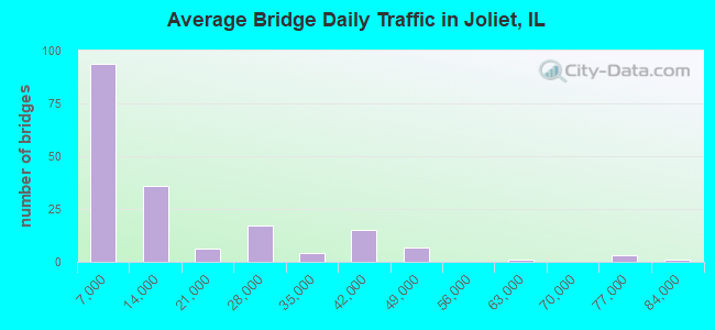
- 2,431,210Total average daily traffic
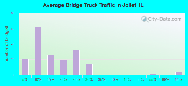
- 444,312Total average daily truck traffic
- National Bridge Inventory (NBI) Registered Bridges for Joliet
- No street view available for this location
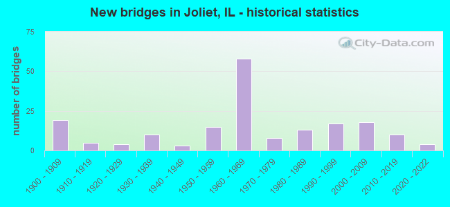
- New bridges - historical statistics
- 191900-1909
- 51910-1919
- 41920-1929
- 101930-1939
- 31940-1949
- 151950-1959
- 581960-1969
- 81970-1979
- 131980-1989
- 171990-1999
- 182000-2009
- 102010-2019
- 42020-2022
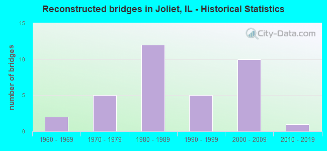
- Reconstructed bridges - Historical Statistics
- 21960-1969
- 51970-1979
- 121980-1989
- 51990-1999
- 102000-2009
- 12010-2019
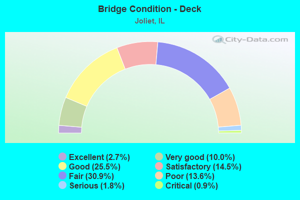
- Bridge Condition - Deck
- 2.7%Excellent
- 10.0%Very good
- 25.5%Good
- 14.5%Satisfactory
- 30.9%Fair
- 13.6%Poor
- 1.8%Serious
- 0.9%Critical
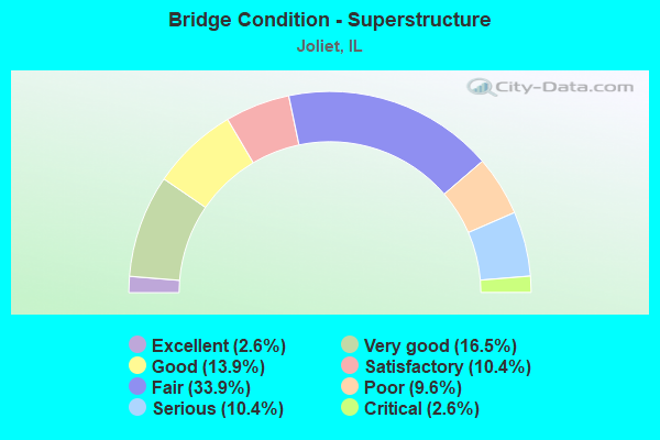
- Bridge Condition - Superstructure
- 2.6%Excellent
- 16.5%Very good
- 13.9%Good
- 10.4%Satisfactory
- 33.9%Fair
- 9.6%Poor
- 10.4%Serious
- 2.6%Critical
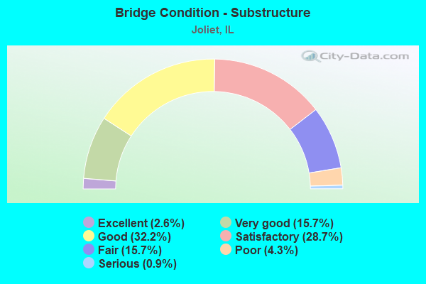
- Bridge Condition - Substructure
- 2.6%Excellent
- 15.7%Very good
- 32.2%Good
- 28.7%Satisfactory
- 15.7%Fair
- 4.3%Poor
- 0.9%Serious
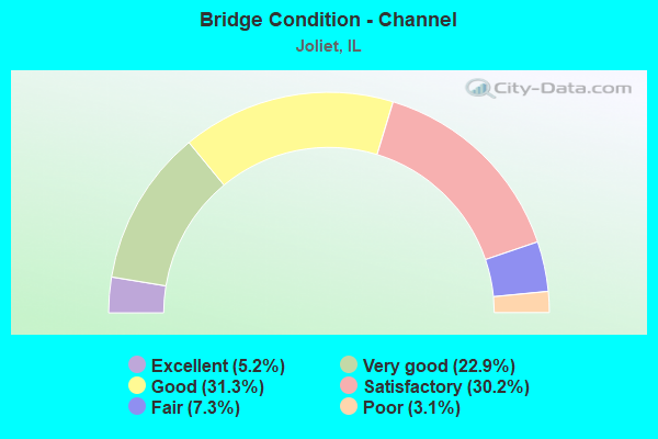
- Bridge Condition - Channel
- 5.2%Excellent
- 22.9%Very good
- 31.3%Good
- 30.2%Satisfactory
- 7.3%Fair
- 3.1%Poor
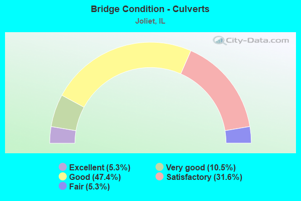
- Bridge Condition - Culverts
- 5.3%Excellent
- 10.5%Very good
- 47.4%Good
- 31.6%Satisfactory
- 5.3%Fair
Find on map >> Show street view
Structure Number: 99991, Location: 0.2 MI E OF ILL 53 (Lat: 41.533389, Lng: -88.079572), Route carried "under" structure: Other road , Year Built: 1900, Structure Length: 0. m, Average Daily Traffic: 5,850 (year 2019), Truck Traffic: 7%, Features Intersected: OHIO ST, Facility Carried by Structure: RR
Minimum Vertical Clearance: 4.27m (14.01ft), Kilometerpoint: 0.064, Lanes under structure: 4, Material/Design: Steel, Design/Construction: Girder and Floorbeam System, Length of Maximum Span: 13.7m (44.9ft)
Find on map >> Show street view
Structure Number: 999911, Location: 0.2 MI S OF WOODRUFF (Lat: 41.543328, Lng: -88.062822), Route carried "under" structure: Other road , Year Built: 1900, Structure Length: 0. m, Average Daily Traffic: 350 (year 2019), Truck Traffic: 11%, Features Intersected: CHARLESWORTH ST, Facility Carried by Structure: RR
Minimum Vertical Clearance: 3.71m (12.17ft), Kilometerpoint: 1.320, Lanes under structure: 2, Material/Design: Steel, Design/Construction: Girder and Floorbeam System, Length of Maximum Span: 9.8m (32.2ft)
Find on map >> Show street view
Structure Number: 999925, Location: S OF DESPLAINES RIV (Lat: 41.497686, Lng: -88.102269), Route carried "under" structure: Other road , Year Built: 1901, Structure Length: 0. m, Average Daily Traffic: 8,200 (year 2019), Truck Traffic: 13%, Features Intersected: BRANDON RD, Facility Carried by Structure: ICG RR
Minimum Vertical Clearance: 3.68m (12.07ft), Kilometerpoint: 0.756, Lanes under structure: 2, Material/Design: Steel, Length of Maximum Span: 7.6m (24.9ft)
Find on map >> Show street view
Structure Number: 99993, Location: .5M S I80-.5 M W 53 (Lat: 41.502431, Lng: -88.090289), Route carried "under" structure: Other road , Year Built: 1900, Structure Length: 0. m, Average Daily Traffic: 1,600 (year 2019), Truck Traffic: 9%, Features Intersected: PATTERSON ST, Facility Carried by Structure: G.M.&O.-A.T.&S.F.
Minimum Vertical Clearance: 3.68m (12.07ft), Kilometerpoint: 1.127, Lanes under structure: 2, Material/Design: Steel, Length of Maximum Span: 9.1m (29.9ft)
Find on map >> Show street view
Structure Number: 999988, Location: 0.35M S of US30 (Lat: 41.519869, Lng: -88.079694), Route carried "under" structure: City street , Year Built: 2013, Structure Length: 0. m, Average Daily Traffic: 1,850 (year 2019), Truck Traffic: 5%, Features Intersected: Osgood St, Facility Carried by Structure: BNSF,UP RR
Minimum Vertical Clearance: 3.78m (12.40ft), Kilometerpoint: 0.129, Lanes under structure: 2, Material/Design: Steel, Design/Construction: Girder and Floorbeam System, Length of Maximum Span: 0.0m