Bridge Statistics for Joliet, Illinois (IL)
Condition, Traffic, Stress, Structural Evaluation, Project Costs
- National Bridge Inventory (NBI) Statistics
- 184Number of bridges
- 2,356ft / 718mTotal length
- $55,737,000Total costs
- 2,431,210Total average daily traffic
- 444,312Total average daily truck traffic
- National Bridge Inventory (NBI) Registered Bridges for Joliet
- No street view available for this location
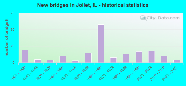
- New bridges - historical statistics
- 191900-1909
- 51910-1919
- 41920-1929
- 101930-1939
- 31940-1949
- 151950-1959
- 581960-1969
- 81970-1979
- 131980-1989
- 171990-1999
- 182000-2009
- 102010-2019
- 42020-2022
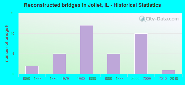
- Reconstructed bridges - Historical Statistics
- 21960-1969
- 51970-1979
- 121980-1989
- 51990-1999
- 102000-2009
- 12010-2019
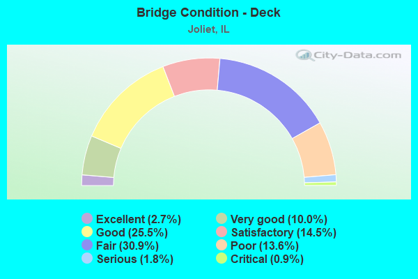
- Bridge Condition - Deck
- 2.7%Excellent
- 10.0%Very good
- 25.5%Good
- 14.5%Satisfactory
- 30.9%Fair
- 13.6%Poor
- 1.8%Serious
- 0.9%Critical
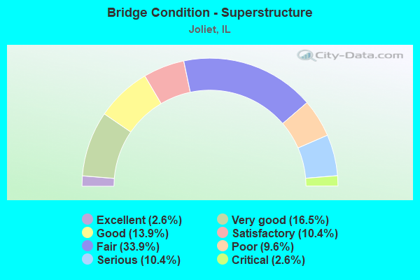
- Bridge Condition - Superstructure
- 2.6%Excellent
- 16.5%Very good
- 13.9%Good
- 10.4%Satisfactory
- 33.9%Fair
- 9.6%Poor
- 10.4%Serious
- 2.6%Critical
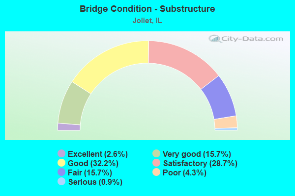
- Bridge Condition - Substructure
- 2.6%Excellent
- 15.7%Very good
- 32.2%Good
- 28.7%Satisfactory
- 15.7%Fair
- 4.3%Poor
- 0.9%Serious
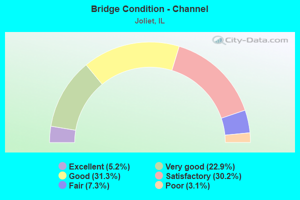
- Bridge Condition - Channel
- 5.2%Excellent
- 22.9%Very good
- 31.3%Good
- 30.2%Satisfactory
- 7.3%Fair
- 3.1%Poor
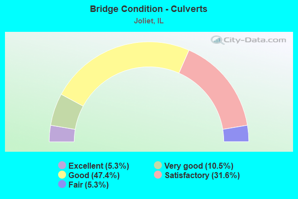
- Bridge Condition - Culverts
- 5.3%Excellent
- 10.5%Very good
- 47.4%Good
- 31.6%Satisfactory
- 5.3%Fair
Find on map >> Show street view
Structure Number: 996463, Location: 2MI W OF IL 53 (Lat: 41.451231, Lng: -88.097506), Route carried "on" structure: City street , Year Built: 2009, Status: Open, Structure Length: 3.05m (10.01ft), Average Daily Traffic: 4,050 (year 2019), Truck Traffic: 26%, Average Future Daily Traffic: 2,050 (year 2036), Design Load: HS 25 or greater, Features Intersected: UNION PACIFIC RR, Facility Carried by Structure: W MILLDSALE RD
Minimum Vertical Clearance: 30+ m (98+ ft), Kilometerpoint: 1.867, Lanes on structure: 2, Owner: City or Municipal Highway Agency, Approaching Roadway Width: 13.4m (44.0ft), Material/Design: Prestressed concrete, Design/Construction: Stringer/Multi-beam, Number Of Spans In Main Unit: 1, Length of Maximum Span: 29.6m (97.1ft), Curb-To-Curb Width: 7.3m (24.0ft), Out-to-Out Width: 14.4m (47.2ft)
Condition: Deck: Good, Superstructure: Good, Substructure: Very good, Operating Rating: 53.8 metric tons, Method Used To Determine Operating Rating: Field evaluation and documented engineering judgment, Inventory Rating: 32.4 metric tons, Method Used To Determine Inventory Rating: Field evaluation and documented engineering judgment, Structural Evaluation: Better than present minimum criteria, Deck Geometry: High priority of replacement, Underclear: Superior to present desirable criteria, Approach Roadway Alignment: Equal to present desirable criteria, Designated Inspection Frequency: Every 48 months, Inspection Date: October 2020, Deck Structure Type: Concrete Cast-file-Place, Wearing Surface/Protective System: Deck Protection: Epoxy Coated Reinforcing
Find on map >> Show street view
Structure Number: 996465, Location: JUST SO OF HOUBOLT (Lat: 41.513881, Lng: -88.171678), Route carried "on" structure: City street , Year Built: 1979, Status: Open, Structure Length: 1.25m (4.10ft), Average Daily Traffic: 3,000 (year 2019), Truck Traffic: 5%, Average Future Daily Traffic: 7,912 (year 2032), Design Load: HS 20+Mod, Features Intersected: ROCK RUN CREEK, Facility Carried by Structure: MCDONOUGH ST
Minimum Vertical Clearance: 30+ m (98+ ft), Kilometerpoint: 1.835, Lanes on structure: 2, Owner: City or Municipal Highway Agency, Approaching Roadway Width: 8.2m (26.9ft), Skew: 2 degrees, Material/Design: Concrete, Design/Construction: Culvert, Number Of Spans In Main Unit: 3, Length of Maximum Span: 4.6m (15.1ft), Curb-To-Curb Width: 9.1m (29.9ft), Out-to-Out Width: 15.2m (49.9ft)
Condition: Channel: Satisfactory, Culverts: Very good, Operating Rating: 54.1 metric tons, Method Used To Determine Operating Rating: Field evaluation and documented engineering judgment, Inventory Rating: 32.4 metric tons, Method Used To Determine Inventory Rating: Field evaluation and documented engineering judgment, Structural Evaluation: Equal to present desirable criteria, Deck Geometry: Meets minimum limits, Waterway Adequacy: Equal to present desirable criteria, Approach Roadway Alignment: Equal to present desirable criteria, Length Of Structure Improvement: 1.89m (6.20ft), Designated Inspection Frequency: Every 48 months, Inspection Date: Febuary 2021, Bridge Improvement Cost: $216,000, Roadway Improvement Cost: $22,000, Total Project Cost: $324,000, Deck Structure Type: Other, Wearing Surface/Protective System: Wearing Surface: Bituminous
Find on map >> Show street view
Structure Number: 996467, Location: 0.25 MI N JACKSON ST (Lat: 41.534883, Lng: -88.064272), Route carried "on" structure: Other road , Year Built: 1925, Year Reconstructed: 1983, Status: Open, Structure Length: 1.22m (4.00ft), Average Daily Traffic: 2,650 (year 2019), Truck Traffic: 13%, Average Future Daily Traffic: 3,621 (year 2032), Design Load: HS 20, Features Intersected: SPRING CR, Facility Carried by Structure: HENDERSON AVE
Minimum Vertical Clearance: 30+ m (98+ ft), Kilometerpoint: 1.352, Lanes on structure: 2, Owner: City or Municipal Highway Agency, Approaching Roadway Width: 9.8m (32.2ft), Material/Design: Prestressed concrete, Design/Construction: Box Beam or Girders - Multiple, Number Of Spans In Main Unit: 1, Length of Maximum Span: 11.6m (38.1ft), Curb or Sidewalk Widths: Left: 2.8m (9.2ft), Right: 2.8m (9.2ft), Curb-To-Curb Width: 9.8m (32.2ft), Out-to-Out Width: 15.9m (52.2ft)
Condition: Deck: Fair, Superstructure: Fair, Substructure: Fair, Channel: Fair, Operating Rating: 46.7 metric tons, Method Used To Determine Operating Rating: Load Factor (LF) rating reported by rating factor (RF) method using MS18 loading, Inventory Rating: 24.3 metric tons, Method Used To Determine Inventory Rating: Load Factor (LF) rating reported by rating factor (RF) method using MS18 loading, Structural Evaluation: Somewhat better than minimum adequacy, Deck Geometry: Meets minimum limits, Waterway Adequacy: Better than present minimum criteria, Approach Roadway Alignment: Better than present minimum criteria, Designated Inspection Frequency: Every 24 months, Inspection Date: Febuary 2021, Deck Structure Type: Concrete Precast Panels, Wearing Surface/Protective System: Wearing Surface: Bituminous, Membrane: Built-up
Find on map >> Show street view
Structure Number: 996469, Location: 100' S HENNEPIN DR (Lat: 41.573039, Lng: -88.162019), Route carried "on" structure: Other road , Year Built: 2010, Status: Open, Structure Length: 0.67m (2.20ft), Average Daily Traffic: 13,900 (year 2019), Truck Traffic: 2%, Average Future Daily Traffic: 30,843 (year 2032), Design Load: HS 20, Features Intersected: SUNNYLAND DRAIN CHAN, Facility Carried by Structure: ESSINGTON ROAD
Minimum Vertical Clearance: 30+ m (98+ ft), Kilometerpoint: 0.756, Lanes on structure: 6, Base Highway Network: Yes, Owner: City or Municipal Highway Agency, Approaching Roadway Width: 20.1m (65.9ft), Material/Design: Concrete, Design/Construction: Culvert, Number Of Spans In Main Unit: 3, Length of Maximum Span: 2.0m (6.6ft), Curb or Sidewalk Widths: Left: 1.8m (5.9ft), Right: 0.0m
Condition: Channel: Very good, Culverts: Very good, Operating Rating: 44.1 metric tons, Method Used To Determine Operating Rating: Assigned rating based on Load Factor Design (LFD) reported by rating factor (RF) using MS18 loading, Inventory Rating: 32.4 metric tons, Method Used To Determine Inventory Rating: Assigned rating based on Load Factor Design (LFD) reported by rating factor (RF) using MS18 loading, Structural Evaluation: Equal to present desirable criteria, Waterway Adequacy: Superior to present desirable criteria, Approach Roadway Alignment: Equal to present desirable criteria, Designated Inspection Frequency: Every 48 months, Inspection Date: Febuary 2020
Find on map >> Show street view
Structure Number: 996472, Location: 100 FT S DEERPATH DR (Lat: 41.525536, Lng: -88.156017), Route carried "on" structure: City street , Year Built: 1986, Status: Open, Structure Length: 1.31m (4.30ft), Average Daily Traffic: 50 (year 2016), Truck Traffic: 24%, Average Future Daily Traffic: 67 (year 2032), Design Load: HS 20, Features Intersected: TRIBUTARY ROCK RUN, Facility Carried by Structure: REBECCA RD
Minimum Vertical Clearance: 30+ m (98+ ft), Kilometerpoint: 0.306, Lanes on structure: 2, Owner: City or Municipal Highway Agency, Approaching Roadway Width: 9.1m (29.9ft), Skew: 2 degrees, Material/Design: Prestressed concrete, Design/Construction: Box Beam or Girders - Multiple, Number Of Spans In Main Unit: 1, Length of Maximum Span: 11.9m (39.0ft), Curb or Sidewalk Widths: Left: 1.5m (4.9ft), Right: 1.5m (4.9ft), Curb-To-Curb Width: 9.1m (29.9ft), Out-to-Out Width: 12.8m (42.0ft)
Condition: Deck: Satisfactory, Superstructure: Satisfactory, Substructure: Good, Channel: Satisfactory, Operating Rating: 44.4 metric tons, Method Used To Determine Operating Rating: Assigned rating based on Load Factor Design (LFD) reported by rating factor (RF) using MS18 loading, Inventory Rating: 32.4 metric tons, Method Used To Determine Inventory Rating: Assigned rating based on Load Factor Design (LFD) reported by rating factor (RF) using MS18 loading, Structural Evaluation: Equal to present minimum criteria, Deck Geometry: Better than present minimum criteria, Waterway Adequacy: Superior to present desirable criteria, Approach Roadway Alignment: Equal to present desirable criteria, Designated Inspection Frequency: Every 24 months, Inspection Date: Febuary 2021, Deck Structure Type: Concrete Precast Panels, Wearing Surface/Protective System: Wearing Surface: Bituminous, Membrane: Built-up
Find on map >> Show street view
Structure Number: 996473, Location: 200 FT N CAMBELL ST (Lat: 41.526350, Lng: -88.149992), Route carried "on" structure: City street , Year Built: 1986, Status: Open, Structure Length: 1.19m (3.90ft), Average Daily Traffic: 650 (year 2019), Truck Traffic: 12%, Average Future Daily Traffic: 1,006 (year 2032), Design Load: HS 20, Features Intersected: TRIBUTARY ROCK RUN, Facility Carried by Structure: FAIRLANE DRIVE
Minimum Vertical Clearance: 30+ m (98+ ft), Kilometerpoint: 1.127, Lanes on structure: 2, Owner: City or Municipal Highway Agency, Approaching Roadway Width: 9.1m (29.9ft), Material/Design: Prestressed concrete, Design/Construction: Box Beam or Girders - Multiple, Number Of Spans In Main Unit: 1, Length of Maximum Span: 10.4m (34.1ft), Curb or Sidewalk Widths: Left: 1.5m (4.9ft), Right: 1.5m (4.9ft), Curb-To-Curb Width: 9.1m (29.9ft), Out-to-Out Width: 12.8m (42.0ft)
Condition: Deck: Fair, Superstructure: Fair, Substructure: Very good, Channel: Very good, Operating Rating: 44.4 metric tons, Method Used To Determine Operating Rating: Assigned rating based on Load Factor Design (LFD) reported by rating factor (RF) using MS18 loading, Inventory Rating: 32.4 metric tons, Method Used To Determine Inventory Rating: Assigned rating based on Load Factor Design (LFD) reported by rating factor (RF) using MS18 loading, Structural Evaluation: Somewhat better than minimum adequacy, Deck Geometry: Equal to present minimum criteria, Waterway Adequacy: Superior to present desirable criteria, Approach Roadway Alignment: Equal to present desirable criteria, Designated Inspection Frequency: Every 24 months, Inspection Date: Febuary 2021, Deck Structure Type: Concrete Precast Panels, Wearing Surface/Protective System: Wearing Surface: Bituminous, Membrane: Built-up
Find on map >> Show street view
Structure Number: 996474, Location: 0.3MI N JEFFERSON ST (Lat: 41.526369, Lng: -88.143292), Route carried "on" structure: Other road , Year Built: 2011, Status: Open, Structure Length: 0.66m (2.17ft), Average Daily Traffic: 3,450 (year 2019), Truck Traffic: 7%, Average Future Daily Traffic: 4,626 (year 2032), Design Load: HS 20, Features Intersected: TRIBUTARY ROCK RUN, Facility Carried by Structure: BARNEY DRIVE
Minimum Vertical Clearance: 30+ m (98+ ft), Kilometerpoint: 0.338, Lanes on structure: 2, Owner: City or Municipal Highway Agency, Approaching Roadway Width: 10.3m (33.8ft), Skew: 3 degrees, Material/Design: Concrete continuous, Design/Construction: Culvert, Number Of Spans In Main Unit: 2, Length of Maximum Span: 3.0m (9.8ft), Curb or Sidewalk Widths: Left: 1.5m (4.9ft), Right: 1.5m (4.9ft), Curb-To-Curb Width: 10.3m (33.8ft), Out-to-Out Width: 10.3m (33.8ft)
Condition: Channel: Very good, Culverts: Good, Operating Rating: 53.8 metric tons, Method Used To Determine Operating Rating: Assigned rating based on Load Factor Design (LFD) reported by rating factor (RF) using MS18 loading, Inventory Rating: 32.4 metric tons, Method Used To Determine Inventory Rating: Assigned rating based on Load Factor Design (LFD) reported by rating factor (RF) using MS18 loading, Structural Evaluation: Better than present minimum criteria, Deck Geometry: Meets minimum limits, Waterway Adequacy: Equal to present desirable criteria, Approach Roadway Alignment: Equal to present desirable criteria, Designated Inspection Frequency: Every 48 months, Inspection Date: January 2021
Find on map >> Show street view
Structure Number: 996475, Location: .1M W DESPLAINES RIV (Lat: 41.525419, Lng: -88.088881), Route carried "on" structure: City street , Year Built: 1991, Status: Open, Structure Length: 2.10m (6.89ft), Average Daily Traffic: 2,500 (year 2019), Truck Traffic: 6%, Average Future Daily Traffic: 2,213 (year 2032), Design Load: HS 20, Features Intersected: JEFFERSON ST, Facility Carried by Structure: BROADWAY ST
Minimum Vertical Clearance: 30+ m (98+ ft), Kilometerpoint: 0.789, Lanes on structure: 2, Lanes under structure: 4, Owner: City or Municipal Highway Agency, Approaching Roadway Width: 9.4m (30.8ft), Material/Design: Prestressed concrete, Design/Construction: Box Beam or Girders - Multiple, Number Of Spans In Main Unit: 5, Number Of Approach Spans: 5, Length of Maximum Span: 20.0m (65.6ft), Curb or Sidewalk Widths: Left: 1.5m (4.9ft), Right: 1.5m (4.9ft), Curb-To-Curb Width: 9.1m (29.9ft), Out-to-Out Width: 13.8m (45.3ft)
Condition: Deck: Satisfactory, Superstructure: Satisfactory, Substructure: Very good, Operating Rating: 44.1 metric tons, Method Used To Determine Operating Rating: Assigned rating based on Load Factor Design (LFD) reported by rating factor (RF) using MS18 loading, Inventory Rating: 32.4 metric tons, Method Used To Determine Inventory Rating: Assigned rating based on Load Factor Design (LFD) reported by rating factor (RF) using MS18 loading, Structural Evaluation: Equal to present minimum criteria, Deck Geometry: Meets minimum limits, Underclear: Meets minimum limits, Approach Roadway Alignment: Equal to present desirable criteria, Designated Inspection Frequency: Every 24 months, Inspection Date: May 2021, Deck Structure Type: Concrete Precast Panels, Wearing Surface/Protective System: Wearing Surface: Bituminous, Membrane: Built-up
Find on map >> Show street view
Structure Number: 996476, Location: .1M S OFI80 (Lat: 41.510839, Lng: -88.078650), Route carried "on" structure: Other road , Year Built: 1996, Status: Open, Structure Length: 4.11m (13.48ft), Average Daily Traffic: 3,300 (year 2019), Truck Traffic: 18%, Average Future Daily Traffic: 2,347 (year 2032), Features Intersected: HICKORY CREEK, Facility Carried by Structure: GARDNER ST
Minimum Vertical Clearance: 30+ m (98+ ft), Kilometerpoint: 0.676, Lanes on structure: 2, Owner: City or Municipal Highway Agency, Approaching Roadway Width: 8.5m (27.9ft), Skew: 4 degrees, Material/Design: Prestressed concrete, Design/Construction: Stringer/Multi-beam, Number Of Spans In Main Unit: 2, Length of Maximum Span: 19.2m (63.0ft), Curb-To-Curb Width: 8.5m (27.9ft), Out-to-Out Width: 12.0m (39.4ft)
Condition: Deck: Good, Superstructure: Good, Substructure: Good, Channel: Good, Operating Rating: 53.8 metric tons, Method Used To Determine Operating Rating: Field evaluation and documented engineering judgment, Inventory Rating: 32.4 metric tons, Method Used To Determine Inventory Rating: Field evaluation and documented engineering judgment, Structural Evaluation: Better than present minimum criteria, Deck Geometry: Meets minimum limits, Waterway Adequacy: Superior to present desirable criteria, Approach Roadway Alignment: Equal to present desirable criteria, Designated Inspection Frequency: Every 48 months, Inspection Date: October 2021, Deck Structure Type: Concrete Cast-file-Place, Wearing Surface/Protective System: Deck Protection: Epoxy Coated Reinforcing
Find on map >> Show street view
Structure Number: 996477, Location: 1.5M E. I-55 (Lat: 41.551086, Lng: -88.151372), Route carried "on" structure: Other road , Year Built: 1996, Status: Open, Structure Length: 4.21m (13.81ft), Average Daily Traffic: 5,850 (year 2019), Truck Traffic: 2%, Average Future Daily Traffic: 10,862 (year 2032), Design Load: HS 20, Features Intersected: ROCK RUN CREEK, Facility Carried by Structure: THEODORE STREET
Minimum Vertical Clearance: 30+ m (98+ ft), Kilometerpoint: 0.805, Lanes on structure: 4, Base Highway Network: Yes, Owner: City or Municipal Highway Agency, Approaching Roadway Width: 12.8m (42.0ft), Material/Design: Prestressed concrete, Design/Construction: Box Beam or Girders - Multiple, Number Of Spans In Main Unit: 3, Length of Maximum Span: 13.8m (45.3ft), Curb or Sidewalk Widths: Left: 1.5m (4.9ft), Right: 1.5m (4.9ft), Curb-To-Curb Width: 13.4m (44.0ft), Out-to-Out Width: 17.1m (56.1ft)
Condition: Deck: Poor, Superstructure: Poor, Substructure: Good, Channel: Satisfactory, Operating Rating: 48.0 metric tons, Method Used To Determine Operating Rating: Load Factor (LF) rating reported by rating factor (RF) method using MS18 loading, Inventory Rating: 28.5 metric tons, Method Used To Determine Inventory Rating: Load Factor (LF) rating reported by rating factor (RF) method using MS18 loading, Structural Evaluation: Meets minimum limits, Deck Geometry: High priority of replacement, Waterway Adequacy: Equal to present desirable criteria, Approach Roadway Alignment: Equal to present desirable criteria, Designated Inspection Frequency: Every 24 months, Inspection Date: Febuary 2021, Deck Structure Type: Concrete Precast Panels, Wearing Surface/Protective System: Wearing Surface: Bituminous, Membrane: Built-up
Find on map >> Show street view
Structure Number: 996478, Location: 0.35M N OF JEFFERSON (Lat: 41.527164, Lng: -88.151206), Route carried "on" structure: Other road , Year Built: 1996, Status: Open, Structure Length: 1.60m (5.25ft), Average Daily Traffic: 8,350 (year 2019), Truck Traffic: 6%, Average Future Daily Traffic: 12,740 (year 2032), Design Load: HS 20, Features Intersected: ROCK RUN CREEK TRIB, Facility Carried by Structure: INFANTRY DR
Minimum Vertical Clearance: 30+ m (98+ ft), Kilometerpoint: 7.934, Lanes on structure: 2, Owner: City or Municipal Highway Agency, Approaching Roadway Width: 13.8m (45.3ft), Material/Design: Prestressed concrete, Design/Construction: Box Beam or Girders - Multiple, Number Of Spans In Main Unit: 1, Length of Maximum Span: 15.1m (49.5ft), Curb or Sidewalk Widths: Left: 2.0m (6.6ft), Right: 2.0m (6.6ft), Curb-To-Curb Width: 13.8m (45.3ft), Out-to-Out Width: 16.2m (53.1ft)
Condition: Deck: Good, Superstructure: Good, Substructure: Satisfactory, Channel: Good, Operating Rating: 44.1 metric tons, Method Used To Determine Operating Rating: Assigned rating based on Load Factor Design (LFD) reported by rating factor (RF) using MS18 loading, Inventory Rating: 32.4 metric tons, Method Used To Determine Inventory Rating: Assigned rating based on Load Factor Design (LFD) reported by rating factor (RF) using MS18 loading, Structural Evaluation: Equal to present minimum criteria, Deck Geometry: Superior to present desirable criteria, Waterway Adequacy: Superior to present desirable criteria, Approach Roadway Alignment: Better than present minimum criteria, Designated Inspection Frequency: Every 24 months, Inspection Date: Febuary 2022, Deck Structure Type: Concrete Precast Panels, Wearing Surface/Protective System: Wearing Surface: Bituminous, Membrane: Built-up
Find on map >> Show street view
Structure Number: 996479, Location: 0.25M N. CATON FARM (Lat: 41.567817, Lng: -88.229472), Route carried "on" structure: Other road , Year Built: 1996, Status: Open, Structure Length: 0.85m (2.79ft), Average Daily Traffic: 9,050 (year 2019), Truck Traffic: 5%, Average Future Daily Traffic: 8,180 (year 2032), Design Load: HS 20, Features Intersected: UNNAMED STREAM, Facility Carried by Structure: DRAUDEN ROAD
Minimum Vertical Clearance: 30+ m (98+ ft), Kilometerpoint: 6.292, Lanes on structure: 2, Owner: City or Municipal Highway Agency, Approaching Roadway Width: 6.1m (20.0ft), Skew: 2 degrees, Material/Design: Concrete, Design/Construction: Culvert, Number Of Spans In Main Unit: 3, Length of Maximum Span: 2.4m (7.9ft), Curb-To-Curb Width: 14.9m (48.9ft), Out-to-Out Width: 16.8m (55.1ft)
Condition: Channel: Satisfactory, Culverts: Satisfactory, Operating Rating: 54.1 metric tons, Method Used To Determine Operating Rating: Field evaluation and documented engineering judgment, Inventory Rating: 32.4 metric tons, Method Used To Determine Inventory Rating: Field evaluation and documented engineering judgment, Structural Evaluation: Equal to present minimum criteria, Deck Geometry: Superior to present desirable criteria, Waterway Adequacy: Better than present minimum criteria, Approach Roadway Alignment: Equal to present desirable criteria, Designated Inspection Frequency: Every 24 months, Inspection Date: Febuary 2021, Deck Structure Type: Other
Find on map >> Show street view
Structure Number: 996499, Location: 0.4 MI E OF RICHARD (Lat: 41.517131, Lng: -88.069119), Route carried "on" structure: City street , Year Built: 2005, Status: Open, Structure Length: 3.75m (12.30ft), Average Daily Traffic: 1,250 (year 2019), Truck Traffic: 8%, Average Future Daily Traffic: 4,962 (year 2032), Design Load: HS 20, Features Intersected: HICKORY CREEK, Facility Carried by Structure: FOURTH AVE
Minimum Vertical Clearance: 30+ m (98+ ft), Kilometerpoint: 0.402, Lanes on structure: 2, Owner: City or Municipal Highway Agency, Approaching Roadway Width: 11.0m (36.1ft), Skew: 2 degrees, Material/Design: Prestressed concrete continuous, Design/Construction: Stringer/Multi-beam, Number Of Spans In Main Unit: 2, Length of Maximum Span: 35.7m (117.1ft), Curb or Sidewalk Widths: Left: 1.5m (4.9ft), Right: 2.4m (7.9ft), Curb-To-Curb Width: 11.0m (36.1ft), Out-to-Out Width: 16.4m (53.8ft)
Condition: Deck: Good, Superstructure: Very good, Substructure: Good, Channel: Very good, Operating Rating: 53.8 metric tons, Method Used To Determine Operating Rating: Assigned rating based on Load Factor Design (LFD) reported by rating factor (RF) using MS18 loading, Inventory Rating: 32.4 metric tons, Method Used To Determine Inventory Rating: Assigned rating based on Load Factor Design (LFD) reported by rating factor (RF) using MS18 loading, Structural Evaluation: Better than present minimum criteria, Deck Geometry: Equal to present minimum criteria, Waterway Adequacy: Equal to present desirable criteria, Approach Roadway Alignment: Equal to present desirable criteria, Designated Inspection Frequency: Every 24 months, Inspection Date: Febuary 2021, Deck Structure Type: Concrete Cast-file-Place, Wearing Surface/Protective System: Deck Protection: Epoxy Coated Reinforcing
Find on map >> Show street view
Structure Number: 996956, Location: 0.60 Mi E of I-55 (Lat: 41.594111, Lng: -88.151494), Route carried "on" structure: City street , Year Built: 2001, Status: Open, Structure Length: 1.95m (6.40ft), Average Daily Traffic: 1,850 (year 2019), Truck Traffic: 9%, Average Future Daily Traffic: 3,340 (year 2020), Features Intersected: Mink Creek, Facility Carried by Structure: Old Renwick Trail
Minimum Vertical Clearance: 30+ m (98+ ft), Kilometerpoint: 0.064, Lanes on structure: 2, Owner: City or Municipal Highway Agency, Approaching Roadway Width: 10.7m (35.1ft), Material/Design: Concrete, Design/Construction: Culvert, Number Of Spans In Main Unit: 3, Length of Maximum Span: 6.1m (20.0ft), Curb or Sidewalk Widths: Left: 1.4m (4.6ft), Right: 1.4m (4.6ft), Curb-To-Curb Width: 10.7m (35.1ft), Out-to-Out Width: 14.0m (45.9ft)
Condition: Channel: Good, Culverts: Good, Operating Rating: 65.8 metric tons, Method Used To Determine Operating Rating: Load Factor (LF) rating reported by rating factor (RF) method using MS18 loading, Inventory Rating: 39.5 metric tons, Method Used To Determine Inventory Rating: Load Factor (LF) rating reported by rating factor (RF) method using MS18 loading, Structural Evaluation: Better than present minimum criteria, Deck Geometry: Equal to present minimum criteria, Waterway Adequacy: Equal to present desirable criteria, Approach Roadway Alignment: Equal to present desirable criteria, Designated Inspection Frequency: Every 48 months, Inspection Date: October 2019, Deck Structure Type: Concrete Cast-file-Place
Find on map >> Show street view
Structure Number: 999101, Location: 0.1 M N Caton Farm R (Lat: 41.566564, Lng: -88.189597), Route carried "on" structure: County highway , Year Built: 2020, Status: Open, Structure Length: 3.17m (10.40ft), Average Daily Traffic: 775 (year 2019), Truck Traffic: 6%, Average Future Daily Traffic: 1,000 (year 2038), Design Load: HS 25 or greater, Features Intersected: Lily Cache Creek, Facility Carried by Structure: Lily Cache Rd
Minimum Vertical Clearance: 30+ m (98+ ft), Kilometerpoint: 0.789, Lanes on structure: 2, Owner: Town or Township Highway Agency, Approaching Roadway Width: 7.0m (23.0ft), Skew: 9 degrees, Material/Design: Prestressed concrete, Design/Construction: Box Beam or Girders - Multiple, Number Of Spans In Main Unit: 3, Length of Maximum Span: 10.4m (34.1ft), Curb-To-Curb Width: 9.1m (29.9ft), Out-to-Out Width: 9.1m (29.9ft)
Condition: Deck: Excellent, Superstructure: Excellent, Substructure: Excellent, Channel: Very good, Operating Rating: 50.5 metric tons, Method Used To Determine Operating Rating: Load and Resistance Factor Rating (LRFR) rating reported by rating factor(RF) method using HL-93 loadings, Inventory Rating: 39.2 metric tons, Method Used To Determine Inventory Rating: Load and Resistance Factor Rating (LRFR) rating reported by rating factor(RF) method using HL-93 loadings, Structural Evaluation: Superior to present desirable criteria, Deck Geometry: Equal to present minimum criteria, Waterway Adequacy: Superior to present desirable criteria, Approach Roadway Alignment: Equal to present desirable criteria, Designated Inspection Frequency: Every 24 months, Inspection Date: July 2020, Deck Structure Type: Concrete Precast Panels, Wearing Surface/Protective System: Wearing Surface: Bituminous
Find on map >> Show street view
Structure Number: 999904, Location: 0.25 M W IL 53 (Lat: 41.516272, Lng: -88.088992), Route carried "on" structure: US 6, Year Built: 1934, Year Reconstructed: 2003, Status: Open, Structure Length: 12.43m (40.78ft), Average Daily Traffic: 10,300 (year 2021), Truck Traffic: 5%, Average Future Daily Traffic: 21,054 (year 2032), Features Intersected: DES PLAINES RIVER
Minimum Vertical Clearance: 5.03m (16.50ft), Kilometerpoint: 233.944, Lanes on structure: 2, Base Highway Network: Yes, Owner: State Highway Agency, Approaching Roadway Width: 9.4m (30.8ft), Skew: 2 degrees, Navigation Control: Yes ( Vertical Clearance: 5.2m (17.1ft), Horizontal Clearance: 45.7m (149.9ft)), Material/Design: Steel, Design/Construction: Movable - Bascule, Number Of Spans In Main Unit: 1, Number Of Approach Spans: 5, Length of Maximum Span: 53.0m (173.9ft), Curb or Sidewalk Widths: Left: 1.8m (5.9ft), Right: 1.8m (5.9ft), Curb-To-Curb Width: 6.9m (22.6ft), Out-to-Out Width: 7.5m (24.6ft)
Condition: Deck: Satisfactory, Superstructure: Poor, Substructure: Satisfactory, Channel: Good, Operating Rating: 71.3 metric tons, Method Used To Determine Operating Rating: Load Factor (LF) rating reported by rating factor (RF) method using MS18 loading, Inventory Rating: 42.4 metric tons, Method Used To Determine Inventory Rating: Load Factor (LF) rating reported by rating factor (RF) method using MS18 loading, Structural Evaluation: Meets minimum limits, Deck Geometry: High priority of replacement, Waterway Adequacy: Superior to present desirable criteria, Approach Roadway Alignment: Equal to present minimum criteria, Length Of Structure Improvement: 12.98m (42.59ft), Designated Inspection Frequency: Every 12 months, Critical Feature Inspection Frequency: Every 12 months, Underwater Inspection Frequency: Every 60 months, Inspection Date: June 2021, Critical Feature Inspection Date: June 2021, Underwater Inspection Date: September 2019, Bridge Improvement Cost: $2,144,000, Roadway Improvement Cost: $214,000, Total Project Cost: $3,216,000, Deck Structure Type: Closed Grating, Wearing Surface/Protective System: Wearing Surface: Other
Find on map >> Show street view
Structure Number: 999918, Location: 0.91 MI N/ARSENAL RD (Lat: 41.434728, Lng: -88.146861), Route carried "on" structure: Other road , Year Built: 2010, Status: Open, Structure Length: 6.55m (21.49ft), Average Daily Traffic: 9,100 (year 2019), Truck Traffic: 64%, Average Future Daily Traffic: 11,117 (year 2030), Design Load: HS 25 or greater, Features Intersected: INTERMODAL YARD LEAD, Facility Carried by Structure: BASELINE ROAD
Minimum Vertical Clearance: 30+ m (98+ ft), Kilometerpoint: 11.667, Lanes on structure: 4, Owner: Private, Approaching Roadway Width: 22.6m (74.1ft), Material/Design: Concrete continuous, Design/Construction: Stringer/Multi-beam, Number Of Spans In Main Unit: 3, Length of Maximum Span: 22.9m (75.1ft), Curb-To-Curb Width: 22.6m (74.1ft), Out-to-Out Width: 23.5m (77.1ft)
Condition: Deck: Satisfactory, Superstructure: Very good, Substructure: Good, Operating Rating: 44.1 metric tons, Method Used To Determine Operating Rating: Assigned rating based on Load Factor Design (LFD) reported by rating factor (RF) using MS18 loading, Inventory Rating: 32.4 metric tons, Method Used To Determine Inventory Rating: Assigned rating based on Load Factor Design (LFD) reported by rating factor (RF) using MS18 loading, Structural Evaluation: Better than present minimum criteria, Deck Geometry: Superior to present desirable criteria, Underclear: Superior to present desirable criteria, Approach Roadway Alignment: Equal to present desirable criteria, Designated Inspection Frequency: Every 24 months, Inspection Date: December 2021, Deck Structure Type: Concrete Cast-file-Place, Wearing Surface/Protective System: Deck Protection: Epoxy Coated Reinforcing
Find on map >> Show street view
Structure Number: 999921, Location: .5 M W of Millsdale (Lat: 41.450269, Lng: -88.126033), Route carried "on" structure: Other road , Year Built: 2009, Status: Open, Structure Length: 1.65m (5.41ft), Average Daily Traffic: 8,350 (year 2019), Truck Traffic: 62%, Average Future Daily Traffic: 2,000 (year 2032), Design Load: HS 25 or greater, Features Intersected: Cedar Creek, Facility Carried by Structure: FAU-8500 (CentPtWa
Minimum Vertical Clearance: 30+ m (98+ ft), Kilometerpoint: 8.738, Lanes on structure: 4, Owner: Private, Approaching Roadway Width: 17.7m (58.1ft), Material/Design: Concrete, Design/Construction: Culvert, Number Of Spans In Main Unit: 4, Length of Maximum Span: 3.9m (12.8ft)
Condition: Channel: Good, Culverts: Satisfactory, Operating Rating: 67.4 metric tons, Method Used To Determine Operating Rating: Assigned rating based on Load Factor Design (LFD) reported by rating factor (RF) using MS18 loading, Inventory Rating: 40.5 metric tons, Method Used To Determine Inventory Rating: Assigned rating based on Load Factor Design (LFD) reported by rating factor (RF) using MS18 loading, Structural Evaluation: Equal to present minimum criteria, Waterway Adequacy: Superior to present desirable criteria, Approach Roadway Alignment: Equal to present minimum criteria, Designated Inspection Frequency: Every 24 months, Inspection Date: December 2021
Find on map >> Show street view
Structure Number: 999922, Location: 0.3 M N of Millsdale (Lat: 41.456778, Lng: -88.118508), Route carried "on" structure: Other road , Year Built: 2009, Status: Open, Structure Length: 0.99m (3.25ft), Average Daily Traffic: 9,200 (year 2019), Truck Traffic: 63%, Average Future Daily Traffic: 1,000 (year 2032), Design Load: HS 25 or greater, Features Intersected: Cedar Creek, Facility Carried by Structure: FAU-8500 (CntPtWay
Minimum Vertical Clearance: 30+ m (98+ ft), Kilometerpoint: 7.435, Lanes on structure: 4, Owner: Private, Approaching Roadway Width: 16.6m (54.5ft), Skew: 4 degrees, Material/Design: Concrete continuous, Design/Construction: Culvert, Number Of Spans In Main Unit: 2, Length of Maximum Span: 5.1m (16.7ft)
Condition: Channel: Very good, Culverts: Satisfactory, Operating Rating: 67.4 metric tons, Method Used To Determine Operating Rating: Assigned rating based on Load Factor Design (LFD) reported by rating factor (RF) using MS18 loading, Inventory Rating: 40.5 metric tons, Method Used To Determine Inventory Rating: Assigned rating based on Load Factor Design (LFD) reported by rating factor (RF) using MS18 loading, Structural Evaluation: Equal to present minimum criteria, Waterway Adequacy: Superior to present desirable criteria, Approach Roadway Alignment: Equal to present desirable criteria, Designated Inspection Frequency: Every 24 months, Inspection Date: December 2021
Find on map >> Show street view
Structure Number: 999923, Location: 0.4 M N of Arsenal (Lat: 41.427039, Lng: -88.146531), Route carried "on" structure: Other road , Year Built: 2010, Status: Open, Structure Length: 1.13m (3.71ft), Average Daily Traffic: 9,100 (year 2019), Truck Traffic: 64%, Average Future Daily Traffic: 3,350 (year 2032), Design Load: HS 20, Features Intersected: Unnamed Tributary, Facility Carried by Structure: FAU-8500 BaselineR
Minimum Vertical Clearance: 30+ m (98+ ft), Kilometerpoint: 12.520, Lanes on structure: 4, Owner: Private, Approaching Roadway Width: 20.8m (68.2ft), Material/Design: Concrete continuous, Design/Construction: Culvert, Number Of Spans In Main Unit: 3, Length of Maximum Span: 3.8m (12.5ft)
Condition: Channel: Very good, Culverts: Good, Operating Rating: 53.8 metric tons, Method Used To Determine Operating Rating: Assigned rating based on Load Factor Design (LFD) reported by rating factor (RF) using MS18 loading, Inventory Rating: 32.4 metric tons, Method Used To Determine Inventory Rating: Assigned rating based on Load Factor Design (LFD) reported by rating factor (RF) using MS18 loading, Structural Evaluation: Better than present minimum criteria, Waterway Adequacy: Superior to present desirable criteria, Approach Roadway Alignment: Equal to present desirable criteria, Designated Inspection Frequency: Every 48 months, Inspection Date: December 2021
Find on map >> Show street view
Structure Number: 990016, Location: 7.2 M N OF I-80 (Lat: 41.583778, Lng: -88.168822), Route carried "under" structure: US 30, Year Built: 1955, Structure Length: 0. m, Average Daily Traffic: 23,600 (year 2021), Truck Traffic: 11%, Features Intersected: US 30, Facility Carried by Structure: I- 55 SB
Minimum Vertical Clearance: 4.52m (14.83ft), Kilometerpoint: 187.258, Lanes on structure: 3, Lanes under structure: 4, Material/Design: Steel continuous, Design/Construction: Stringer/Multi-beam, Length of Maximum Span: 16.4m (53.8ft)
Find on map >> Show street view
Structure Number: 990017, Location: 7.2 M N OF I-80 (Lat: 41.583650, Lng: -88.168442), Route carried "under" structure: US 30, Year Built: 1955, Structure Length: 0. m, Average Daily Traffic: 23,600 (year 2021), Truck Traffic: 11%, Features Intersected: US 30, Facility Carried by Structure: I- 55 NB
Minimum Vertical Clearance: 4.60m (15.09ft), Kilometerpoint: 187.290, Lanes on structure: 3, Lanes under structure: 4, Material/Design: Steel continuous, Design/Construction: Stringer/Multi-beam, Length of Maximum Span: 16.4m (53.8ft)
Find on map >> Show street view
Structure Number: 990051, Location: 0.6 M E IL-7 (Lat: 41.511439, Lng: -88.114711), Route carried "under" structure: Other road , Year Built: 1963, Structure Length: 0. m, Average Daily Traffic: 3,750 (year 2019), Truck Traffic: 2%, Features Intersected: MIDLAND AVE, Facility Carried by Structure: I- 80 WB
Minimum Vertical Clearance: 4.27m (14.01ft), Kilometerpoint: 3.766, Lanes on structure: 2, Lanes under structure: 4, Material/Design: Steel continuous, Design/Construction: Stringer/Multi-beam, Length of Maximum Span: 16.8m (55.1ft)
Find on map >> Show street view
Structure Number: 990052, Location: 1.3 M E OF IL-7 (Lat: 41.511708, Lng: -88.100042), Route carried "under" structure: Other road , Year Built: 1965, Structure Length: 0. m, Average Daily Traffic: 2,000 (year 2019), Truck Traffic: 6%, Features Intersected: CENTER ST SB, Facility Carried by Structure: I- 80 EB
Minimum Vertical Clearance: 4.80m (15.75ft), Kilometerpoint: 0.547, Lanes on structure: 2, Lanes under structure: 2, Material/Design: Steel continuous, Design/Construction: Stringer/Multi-beam, Length of Maximum Span: 15.1m (49.5ft)
Find on map >> Show street view
Structure Number: 990053, Location: 1.3 M E OF IL-7 (Lat: 41.512039, Lng: -88.100064), Route carried "under" structure: Other road , Year Built: 1965, Structure Length: 0. m, Average Daily Traffic: 2,000 (year 2019), Truck Traffic: 6%, Features Intersected: CENTER ST SB, Facility Carried by Structure: I- 80 WB
Minimum Vertical Clearance: 4.70m (15.42ft), Kilometerpoint: 0.515, Lanes on structure: 2, Lanes under structure: 2, Material/Design: Steel continuous, Design/Construction: Stringer/Multi-beam, Length of Maximum Span: 16.7m (54.8ft)
Find on map >> Show street view
Structure Number: 990054, Location: 0.3 M W OF US-6 (Lat: 41.513119, Lng: -88.098853), Route carried "under" structure: Other road , Year Built: 1965, Structure Length: 0. m, Average Daily Traffic: 3,350 (year 2019), Truck Traffic: 6%, Features Intersected: CENTER SB TO I-80 EB, Facility Carried by Structure: I- 80 WB
Minimum Vertical Clearance: 5.61m (18.41ft), Kilometerpoint: 0.306, Lanes on structure: 2, Lanes under structure: 2, Material/Design: Steel, Design/Construction: Stringer/Multi-beam, Length of Maximum Span: 26.8m (87.9ft)
Find on map >> Show street view
Structure Number: 990055, Location: 0.3 M W OF US-6 (Lat: 41.512911, Lng: -88.098669), Route carried "under" structure: Other road , Year Built: 1965, Structure Length: 0. m, Average Daily Traffic: 3,350 (year 2019), Truck Traffic: 6%, Features Intersected: CENTER SB TO I-80 EB, Facility Carried by Structure: I- 80 EB
Minimum Vertical Clearance: 4.70m (15.42ft), Kilometerpoint: 0.338, Lanes on structure: 2, Lanes under structure: 2, Material/Design: Steel, Design/Construction: Stringer/Multi-beam, Length of Maximum Span: 33.5m (109.9ft)
Find on map >> Show street view
Structure Number: 990056, Location: 1.5 M E OF IL-7 (Lat: 41.512039, Lng: -88.094078), Route carried "under" structure: US 6, Year Built: 1965, Structure Length: 0. m, Average Daily Traffic: 3,500 (year 2021), Truck Traffic: 11%, Features Intersected: DS PLNS RIV & US-6, Facility Carried by Structure: I- 80 EB
Minimum Vertical Clearance: 11.89m (39.01ft), Kilometerpoint: 233.220, Lanes on structure: 3, Lanes under structure: 4, Material/Design: Steel continuous, Design/Construction: Truss - Thru, Length of Maximum Span: 110.6m (362.9ft)
Find on map >> Show street view
Structure Number: 990057, Location: 1.5 M E OF IL-7 (Lat: 41.512319, Lng: -88.093783), Route carried "under" structure: US 6, Year Built: 1965, Structure Length: 0. m, Average Daily Traffic: 3,500 (year 2021), Truck Traffic: 11%, Features Intersected: DS PLNS RIV & US-6, Facility Carried by Structure: I- 80 WB
Minimum Vertical Clearance: 11.89m (39.01ft), Kilometerpoint: 233.252, Lanes on structure: 3, Lanes under structure: 4, Material/Design: Steel continuous, Design/Construction: Truss - Thru, Length of Maximum Span: 110.6m (362.9ft)
Find on map >> Show street view
Structure Number: 990058, Location: 2.2 M E OF IL-7 (Lat: 41.511422, Lng: -88.081953), Route carried "under" structure: US 52, Year Built: 1967, Structure Length: 0. m, Average Daily Traffic: 24,800 (year 2021), Truck Traffic: 26%, Features Intersected: IL 53, Facility Carried by Structure: I- 80 WB
Minimum Vertical Clearance: 4.55m (14.93ft), Kilometerpoint: 227.265, Lanes on structure: 3, Lanes under structure: 6, Material/Design: Steel, Design/Construction: Stringer/Multi-beam, Length of Maximum Span: 29.5m (96.8ft)
Find on map >> Show street view
Structure Number: 990059, Location: 2.2 M E OF IL-7 (Lat: 41.511522, Lng: -88.081992), Route carried "under" structure: US 52, Year Built: 1967, Structure Length: 0. m, Average Daily Traffic: 24,800 (year 2021), Truck Traffic: 26%, Features Intersected: IL 53, Facility Carried by Structure: I- 80 EB
Minimum Vertical Clearance: 4.65m (15.26ft), Kilometerpoint: 227.249, Lanes on structure: 3, Lanes under structure: 6, Material/Design: Steel, Design/Construction: Stringer/Multi-beam, Length of Maximum Span: 29.5m (96.8ft)
Find on map >> Show street view
Structure Number: 99006, Location: 0.1 M E OF IL-53 (Lat: 41.511981, Lng: -88.078689), Route carried "under" structure: Other road , Year Built: 1964, Structure Length: 0. m, Average Daily Traffic: 3,300 (year 2019), Truck Traffic: 18%, Features Intersected: RR & GARDNER ST, Facility Carried by Structure: I- 80 EB
Minimum Vertical Clearance: 11.81m (38.75ft), Kilometerpoint: 0.547, Lanes on structure: 3, Lanes under structure: 2, Material/Design: Steel continuous, Design/Construction: Stringer/Multi-beam, Length of Maximum Span: 29.3m (96.1ft)
Find on map >> Show street view
Structure Number: 990061, Location: 0.1 M E OF IL-53 (Lat: 41.512303, Lng: -88.078697), Route carried "under" structure: Other road , Year Built: 1964, Structure Length: 0. m, Average Daily Traffic: 3,300 (year 2019), Truck Traffic: 18%, Features Intersected: RR & GARDNER ST, Facility Carried by Structure: I- 80 WB
Minimum Vertical Clearance: 11.81m (38.75ft), Kilometerpoint: 0.515, Lanes on structure: 3, Lanes under structure: 2, Material/Design: Steel continuous, Design/Construction: Stringer/Multi-beam, Length of Maximum Span: 29.3m (96.1ft)
Find on map >> Show street view
Structure Number: 990064, Location: 0.4 M E OF IL-53 (Lat: 41.512814, Lng: -88.073072), Route carried "under" structure: Other road , Year Built: 1965, Structure Length: 0. m, Average Daily Traffic: 9,550 (year 2019), Truck Traffic: 12%, Features Intersected: RICHARDS ST, Facility Carried by Structure: I- 80 EB
Minimum Vertical Clearance: 4.29m (14.07ft), Kilometerpoint: 1.352, Lanes on structure: 2, Lanes under structure: 5, Material/Design: Steel, Design/Construction: Stringer/Multi-beam, Length of Maximum Span: 25.1m (82.3ft)
Find on map >> Show street view
Structure Number: 990065, Location: 0.3 M E OF IL-53 (Lat: 41.513061, Lng: -88.073081), Route carried "under" structure: Other road , Year Built: 1965, Structure Length: 0. m, Average Daily Traffic: 7,950 (year 2019), Truck Traffic: 9%, Features Intersected: RICHARDS ST, Facility Carried by Structure: I- 80 WB
Minimum Vertical Clearance: 4.29m (14.07ft), Kilometerpoint: 1.320, Lanes on structure: 2, Lanes under structure: 5, Material/Design: Steel, Design/Construction: Stringer/Multi-beam, Length of Maximum Span: 24.8m (81.4ft)
Find on map >> Show street view
Structure Number: 990066, Location: 0.9 M E OF IL-53 (Lat: 41.513139, Lng: -88.061978), Route carried "under" structure: Other road , Year Built: 1965, Structure Length: 0. m, Average Daily Traffic: 1,550 (year 2019), Truck Traffic: 18%, Features Intersected: RR & ROWELL AVE, Facility Carried by Structure: I- 80 EB
Minimum Vertical Clearance: 7.47m (24.51ft), Kilometerpoint: 0.869, Lanes on structure: 2, Lanes under structure: 2, Material/Design: Steel continuous, Design/Construction: Stringer/Multi-beam, Length of Maximum Span: 31.1m (102.0ft)
Find on map >> Show street view
Structure Number: 990067, Location: 0.9 M E OF IL-53 (Lat: 41.513386, Lng: -88.061989), Route carried "under" structure: Other road , Year Built: 1965, Structure Length: 0. m, Average Daily Traffic: 1,550 (year 2019), Truck Traffic: 18%, Features Intersected: RR & ROWELL AVE, Facility Carried by Structure: I- 80 WB
Minimum Vertical Clearance: 7.54m (24.74ft), Kilometerpoint: 0.837, Lanes on structure: 2, Lanes under structure: 2, Material/Design: Steel continuous, Design/Construction: Stringer/Multi-beam, Length of Maximum Span: 31.1m (102.0ft)
Find on map >> Show street view
Structure Number: 990074, Location: I-80 & CENTER ST (Lat: 41.511378, Lng: -88.100031), Route carried "under" structure: Other road , Year Built: 1966, Structure Length: 0. m, Average Daily Traffic: 2,000 (year 2019), Truck Traffic: 6%, Features Intersected: CENTER ST SB, Facility Carried by Structure: I- 80 EB TO CENTER
Minimum Vertical Clearance: 4.65m (15.26ft), Kilometerpoint: 0.579, Lanes on structure: 1, Lanes under structure: 2, Material/Design: Steel continuous, Design/Construction: Stringer/Multi-beam, Length of Maximum Span: 14.1m (46.3ft)
Find on map >> Show street view
Structure Number: 990075, Location: 0.25 SW US52-N I80 (Lat: 41.513722, Lng: -88.099064), Route carried "under" structure: Other road , Year Built: 1966, Structure Length: 0. m, Average Daily Traffic: 3,350 (year 2019), Truck Traffic: 6%, Features Intersected: CENTER SB TO I-80 EB, Facility Carried by Structure: I- 80 WB TO MEDOW
Minimum Vertical Clearance: 4.80m (15.75ft), Kilometerpoint: 0.225, Lanes on structure: 1, Lanes under structure: 2, Material/Design: Steel, Design/Construction: Stringer/Multi-beam, Length of Maximum Span: 20.8m (68.2ft)
Find on map >> Show street view
Structure Number: 990084, Location: 0.3M S OF I-80 (Lat: 41.508656, Lng: -88.081081), Route carried "under" structure: US 52, Year Built: 1937, Structure Length: 0. m, Average Daily Traffic: 24,800 (year 2021), Truck Traffic: 26%, Features Intersected: US 52,ILL 53, Facility Carried by Structure: AT&SF RR
Minimum Vertical Clearance: 4.57m (14.99ft), Kilometerpoint: 227.571, Lanes under structure: 4, Material/Design: Steel, Design/Construction: Girder and Floorbeam System, Length of Maximum Span: 36.0m (118.1ft)
Find on map >> Show street view
Structure Number: 990085, Location: 0.4 MI S OF I-80 (Lat: 41.507039, Lng: -88.081033), Route carried "under" structure: US 52, Year Built: 1937, Structure Length: 0. m, Average Daily Traffic: 24,800 (year 2021), Truck Traffic: 26%, Features Intersected: RTE 53, Facility Carried by Structure: ICG RR
Minimum Vertical Clearance: 4.39m (14.40ft), Kilometerpoint: 227.748, Lanes under structure: 4, Material/Design: Steel, Design/Construction: Girder and Floorbeam System, Length of Maximum Span: 17.7m (58.1ft)
Find on map >> Show street view
Structure Number: 990102, Location: US 30 .1M E ILL 53 (Lat: 41.527878, Lng: -88.079042), Route carried "under" structure: US 6, Year Built: 1900, Structure Length: 0. m, Average Daily Traffic: 9,000 (year 2021), Truck Traffic: 3%, Features Intersected: US 30 W BOUND, Facility Carried by Structure: ATSF CMO RR
Minimum Vertical Clearance: 4.11m (13.48ft), Kilometerpoint: 233.413, Lanes under structure: 3, Material/Design: Steel, Design/Construction: Girder and Floorbeam System, Length of Maximum Span: 7.6m (24.9ft)
Find on map >> Show street view
Structure Number: 990108, Location: 2.0 M W OF IL-53 (Lat: 41.511156, Lng: -88.124431), Route carried "under" structure: Interstate 80, Year Built: 1964, Structure Length: 0. m, Average Daily Traffic: 76,600 (year 2021), Truck Traffic: 22%, Features Intersected: I- 80, Facility Carried by Structure: IL 7
Minimum Vertical Clearance: 5.05m (16.57ft), Kilometerpoint: 210.255, Lanes on structure: 6, Lanes under structure: 6, Material/Design: Steel continuous, Design/Construction: Stringer/Multi-beam, Length of Maximum Span: 25.9m (85.0ft)
Find on map >> Show street view
Structure Number: 990145, Location: 0.7M N OF US 6 (Lat: 41.523728, Lng: -88.082961), Route carried "under" structure: US 6, Year Built: 1900, Structure Length: 0. m, Average Daily Traffic: 4,810 (year 2021), Truck Traffic: 13%, Features Intersected: OTTAWA ST, Facility Carried by Structure: CRI&PRR
Minimum Vertical Clearance: 4.39m (14.40ft), Kilometerpoint: 232.608, Lanes under structure: 4, Material/Design: Steel, Design/Construction: Stringer/Multi-beam, Length of Maximum Span: 12.8m (42.0ft)
Find on map >> Show street view
Structure Number: 990175, Location: 1.0 M E OF IL-7 (Lat: 41.511700, Lng: -88.105164), Route carried "under" structure: Interstate 80, Year Built: 1966, Structure Length: 0. m, Average Daily Traffic: 76,600 (year 2021), Truck Traffic: 22%, Features Intersected: I- 80, Facility Carried by Structure: WHEELER AVE
Minimum Vertical Clearance: 5.05m (16.57ft), Kilometerpoint: 211.945, Lanes on structure: 4, Lanes under structure: 5, Material/Design: Steel continuous, Design/Construction: Stringer/Multi-beam, Length of Maximum Span: 24.5m (80.4ft)
Find on map >> Show street view
Structure Number: 990186, Location: US 52 WEST OF US 6 (Lat: 41.516111, Lng: -88.095461), Route carried "under" structure: US 52, Year Built: 1965, Structure Length: 0. m, Average Daily Traffic: 9,200 (year 2021), Truck Traffic: 2%, Features Intersected: US 52, Facility Carried by Structure: CENTER ST
Minimum Vertical Clearance: 4.75m (15.58ft), Kilometerpoint: 225.495, Lanes on structure: 4, Lanes under structure: 2, Material/Design: Steel continuous, Design/Construction: Stringer/Multi-beam, Length of Maximum Span: 34.2m (112.2ft)
Find on map >> Show street view
Structure Number: 990187, Location: 1 M W IL53-.08 N I80 (Lat: 41.513519, Lng: -88.097917), Route carried "under" structure: Other road , Year Built: 1967, Structure Length: 0. m, Average Daily Traffic: 1,050 (year 2019), Truck Traffic: 19%, Features Intersected: I- 80 WB TO CENTERSB, Facility Carried by Structure: CENTER ST NB
Minimum Vertical Clearance: 4.57m (14.99ft), Kilometerpoint: 0.161, Lanes on structure: 1, Lanes under structure: 1, Material/Design: Steel continuous, Design/Construction: Stringer/Multi-beam, Length of Maximum Span: 13.7m (44.9ft)
Find on map >> Show street view
Structure Number: 990188, Location: 1.0 M W OF IL-53 (Lat: 41.512711, Lng: -88.098581), Route carried "under" structure: Interstate 80, Year Built: 1965, Structure Length: 0. m, Average Daily Traffic: 77,200 (year 2021), Truck Traffic: 21%, Features Intersected: I- 80, Facility Carried by Structure: CENTER ST NB
Minimum Vertical Clearance: 5.38m (17.65ft), Kilometerpoint: 212.476, Lanes on structure: 2, Lanes under structure: 4, Material/Design: Steel continuous, Design/Construction: Stringer/Multi-beam, Length of Maximum Span: 23.1m (75.8ft)
Find on map >> Show street view
Structure Number: 990209, Location: 1.0 M N OF US 52 (Lat: 41.536281, Lng: -88.179881), Route carried "under" structure: Interstate 55, Year Built: 1959, Structure Length: 0. m, Average Daily Traffic: 70,400 (year 2021), Truck Traffic: 19%, Features Intersected: I- 55, Facility Carried by Structure: BLACK RD
Minimum Vertical Clearance: 4.75m (15.58ft), Kilometerpoint: 408.666, Lanes on structure: 4, Lanes under structure: 6, Material/Design: Steel continuous, Design/Construction: Stringer/Multi-beam, Length of Maximum Span: 17.2m (56.4ft)
Find on map >> Show street view
Structure Number: 990218, Location: 0.1 MI E OF ILL 53 (Lat: 41.516911, Lng: -88.079714), Route carried "under" structure: Other road , Year Built: 1900, Structure Length: 0. m, Average Daily Traffic: 8,450 (year 2021), Truck Traffic: 3%, Features Intersected: US6 WB, Facility Carried by Structure: GM&O RR
Minimum Vertical Clearance: 4.01m (13.16ft), Kilometerpoint: 1.706, Lanes under structure: 2, Material/Design: Steel, Design/Construction: Girder and Floorbeam System, Length of Maximum Span: 11.0m (36.1ft)
Find on map >> Show street view
Structure Number: 99022, Location: 0.1 M S OF US 30 (Lat: 41.523744, Lng: -88.081556), Route carried "under" structure: US 6, Year Built: 1901, Structure Length: 0. m, Average Daily Traffic: 10,850 (year 2021), Truck Traffic: 20%, Features Intersected: ILL 53 (CHICAGO ST), Facility Carried by Structure: CRI&PRR
Minimum Vertical Clearance: 4.50m (14.76ft), Kilometerpoint: 235.392, Lanes under structure: 2, Material/Design: Steel, Design/Construction: Stringer/Multi-beam, Length of Maximum Span: 6.7m (22.0ft)
Find on map >> Show street view
Structure Number: 990221, Location: 500 E OF DESPLAIN R (Lat: 41.536247, Lng: -88.081456), Route carried "under" structure: State highway 53, Year Built: 1907, Structure Length: 0. m, Average Daily Traffic: 7,500 (year 2021), Truck Traffic: 8%, Features Intersected: ILL 53 W BOUND, Facility Carried by Structure: SANTAFE RR
Minimum Vertical Clearance: 4.60m (15.09ft), Kilometerpoint: 49.711, Lanes under structure: 4, Material/Design: Steel, Design/Construction: Girder and Floorbeam System, Length of Maximum Span: 12.8m (42.0ft)
Find on map >> Show street view
Structure Number: 990222, Location: 0.5 MI N OF US 30 (Lat: 41.535031, Lng: -88.080400), Route carried "under" structure: State highway 53, Year Built: 1900, Structure Length: 0. m, Average Daily Traffic: 7,500 (year 2021), Truck Traffic: 8%, Features Intersected: ILL 53 N BOUND, Facility Carried by Structure: SANTAFE RR
Minimum Vertical Clearance: 4.17m (13.68ft), Kilometerpoint: 49.502, Lanes under structure: 4, Material/Design: Steel, Design/Construction: Girder and Floorbeam System, Length of Maximum Span: 18.3m (60.0ft)
Find on map >> Show street view
Structure Number: 990224, Location: 1.4M N OF US 6 (Lat: 41.551228, Lng: -88.072711), Route carried "under" structure: State highway 171, Year Built: 1918, Structure Length: 0. m, Average Daily Traffic: 10,500 (year 2021), Truck Traffic: 9%, Features Intersected: ILL 171, Facility Carried by Structure: EJ&E RR
Minimum Vertical Clearance: 4.22m (13.85ft), Kilometerpoint: 12.005, Lanes under structure: 4, Material/Design: Steel, Design/Construction: Girder and Floorbeam System, Length of Maximum Span: 13.4m (44.0ft)
Find on map >> Show street view
Structure Number: 990227, Location: 0.38M.E.OF BRIGGS ST (Lat: 41.529900, Lng: -88.036683), Route carried "under" structure: US 30, Year Built: 1900, Structure Length: 0. m, Average Daily Traffic: 8,750 (year 2021), Truck Traffic: 6%, Features Intersected: US 30, Facility Carried by Structure: CRI & P RR (METRA)
Minimum Vertical Clearance: 4.52m (14.83ft), Kilometerpoint: 201.645, Lanes under structure: 2, Material/Design: Steel, Design/Construction: Girder and Floorbeam System, Length of Maximum Span: 11.0m (36.1ft)
Find on map >> Show street view
Structure Number: 990228, Location: .12 E OF IL-53 (Lat: 41.515108, Lng: -88.079267), Route carried "under" structure: Other road , Year Built: 1900, Structure Length: 0. m, Average Daily Traffic: 1,350 (year 2019), Truck Traffic: 10%, Features Intersected: US 6 EB, Facility Carried by Structure: GM&O RR
Minimum Vertical Clearance: 4.11m (13.48ft), Kilometerpoint: 0.129, Lanes under structure: 2, Material/Design: Steel, Design/Construction: Girder and Floorbeam System, Length of Maximum Span: 12.8m (42.0ft)
Find on map >> Show street view
Structure Number: 99023, Location: 0.1 MI E OF IL 53 (Lat: 41.515097, Lng: -88.079742), Route carried "under" structure: Other road , Year Built: 1900, Structure Length: 0. m, Average Daily Traffic: 1,350 (year 2019), Truck Traffic: 10%, Features Intersected: US 6 EB, Facility Carried by Structure: SANTAFE RR
Minimum Vertical Clearance: 4.17m (13.68ft), Kilometerpoint: 0.097, Lanes under structure: 3, Material/Design: Steel, Design/Construction: Girder and Floorbeam System, Length of Maximum Span: 12.8m (42.0ft)
Find on map >> Show street view
Structure Number: 990231, Location: 0.1 MI E OF ILL 53 (Lat: 41.516911, Lng: -88.079978), Route carried "under" structure: Other road , Year Built: 1900, Structure Length: 0. m, Average Daily Traffic: 8,450 (year 2021), Truck Traffic: 3%, Features Intersected: US 6 WB, Facility Carried by Structure: SANTAFE RR
Minimum Vertical Clearance: 4.01m (13.16ft), Kilometerpoint: 1.690, Lanes under structure: 2, Material/Design: Steel, Design/Construction: Girder and Floorbeam System, Length of Maximum Span: 11.0m (36.1ft)
Find on map >> Show street view
Structure Number: 990233, Location: US 6 S OF US 30 (Lat: 41.524325, Lng: -88.074597), Route carried "under" structure: Other road , Year Built: 1900, Structure Length: 0. m, Average Daily Traffic: 6,650 (year 2019), Truck Traffic: 8%, Features Intersected: US 6, Facility Carried by Structure: ROCK ISLAND RR
Minimum Vertical Clearance: 3.71m (12.17ft), Kilometerpoint: 0.048, Lanes under structure: 2, Material/Design: Steel, Design/Construction: Girder and Floorbeam System, Length of Maximum Span: 12.8m (42.0ft)
Find on map >> Show street view
Structure Number: 990234, Location: 0.1 MI E IL 53 NB (Lat: 41.525025, Lng: -88.079108), Route carried "under" structure: US 6, Year Built: 1900, Structure Length: 0. m, Average Daily Traffic: 2,800 (year 2021), Truck Traffic: 12%, Features Intersected: US 30 E BOUND, Facility Carried by Structure: ATSF GMO RR
Minimum Vertical Clearance: 4.11m (13.48ft), Kilometerpoint: 235.714, Lanes under structure: 2, Material/Design: Steel, Design/Construction: Girder and Floorbeam System, Length of Maximum Span: 6.4m (21.0ft)
Find on map >> Show street view
Structure Number: 990301, Location: 1.5 M E OF I-55 (Lat: 41.491758, Lng: -88.167336), Route carried "under" structure: Other road , Year Built: 1993, Structure Length: 0. m, Average Daily Traffic: 14,500 (year 2019), Truck Traffic: 5%, Features Intersected: HOUBOLT RD, Facility Carried by Structure: I- 80 EB
Minimum Vertical Clearance: 4.67m (15.32ft), Kilometerpoint: 3.380, Lanes on structure: 2, Lanes under structure: 5, Material/Design: Steel, Design/Construction: Stringer/Multi-beam, Length of Maximum Span: 44.5m (146.0ft)
Find on map >> Show street view
Structure Number: 990302, Location: 1.5 M E OF I-55 (Lat: 41.491967, Lng: -88.167503), Route carried "under" structure: Other road , Year Built: 1993, Structure Length: 0. m, Average Daily Traffic: 14,500 (year 2019), Truck Traffic: 5%, Features Intersected: HOUBOLT RD, Facility Carried by Structure: I- 80 WB
Minimum Vertical Clearance: 4.45m (14.60ft), Kilometerpoint: 3.347, Lanes on structure: 2, Lanes under structure: 4, Material/Design: Steel, Design/Construction: Stringer/Multi-beam, Length of Maximum Span: 44.5m (146.0ft)
Find on map >> Show street view
Structure Number: 994642, Location: 1 MI. N. OF I-80 (Lat: 41.502800, Lng: -88.197986), Route carried "under" structure: Interstate 55, Year Built: 2009, Structure Length: 0. m, Average Daily Traffic: 60,000 (year 2021), Truck Traffic: 23%, Features Intersected: I- 55
Minimum Vertical Clearance: 6.96m (22.83ft), Kilometerpoint: 404.658, Lanes on structure: 1, Lanes under structure: 6, Material/Design: Steel continuous, Design/Construction: Stringer/Multi-beam, Length of Maximum Span: 50.0m (164.0ft)
Find on map >> Show street view
Structure Number: 996475, Location: .1M W DESPLAINES RIV (Lat: 41.524989, Lng: -88.088953), Route carried "under" structure: US 30, Year Built: 1991, Structure Length: 0. m, Average Daily Traffic: 1,510 (year 2021), Truck Traffic: 7%, Features Intersected: JEFFERSON ST, Facility Carried by Structure: BROADWAY ST
Minimum Vertical Clearance: 4.83m (15.85ft), Kilometerpoint: 196.930, Lanes on structure: 2, Lanes under structure: 4, Material/Design: Prestressed concrete, Design/Construction: Box Beam or Girders - Multiple, Length of Maximum Span: 20.0m (65.6ft)
Find on map >> Show street view
Structure Number: 9999, Location: 0.06M N of US6 (Lat: 41.525975, Lng: -88.079119), Route carried "under" structure: City street , Year Built: 2013, Structure Length: 0. m, Average Daily Traffic: 875 (year 2019), Truck Traffic: 14%, Features Intersected: Van Buren St, Facility Carried by Structure: BNSF,UP RR
Minimum Vertical Clearance: 3.61m (11.84ft), Kilometerpoint: 0.274, Lanes under structure: 2, Material/Design: Steel, Design/Construction: Girder and Floorbeam System, Length of Maximum Span: 4.3m (14.1ft)