Bridge Statistics for Detroit, Michigan (MI)
Condition, Traffic, Stress, Structural Evaluation, Project Costs
- National Bridge Inventory (NBI) Statistics
- 1,085Number of bridges
- 12,034ft / 3,668mTotal length
- $82,595,000Total costs
- 55,047,582Total average daily traffic
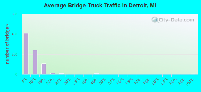
- 3,107,918Total average daily truck traffic
- National Bridge Inventory (NBI) Registered Bridges for Detroit
- No street view available for this location
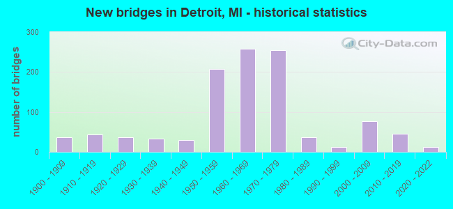
- New bridges - historical statistics
- 1Before 1900
- 371900-1909
- 431910-1919
- 371920-1929
- 331930-1939
- 291940-1949
- 2071950-1959
- 2591960-1969
- 2551970-1979
- 361980-1989
- 131990-1999
- 762000-2009
- 462010-2019
- 132020-2022
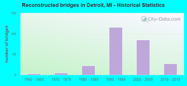
- Reconstructed bridges - Historical Statistics
- 31960-1969
- 51970-1979
- 221980-1989
- 1161990-1999
- 852000-2009
- 272010-2019
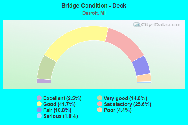
- Bridge Condition - Deck
- 2.5%Excellent
- 14.0%Very good
- 41.7%Good
- 25.6%Satisfactory
- 10.8%Fair
- 4.4%Poor
- 1.0%Serious
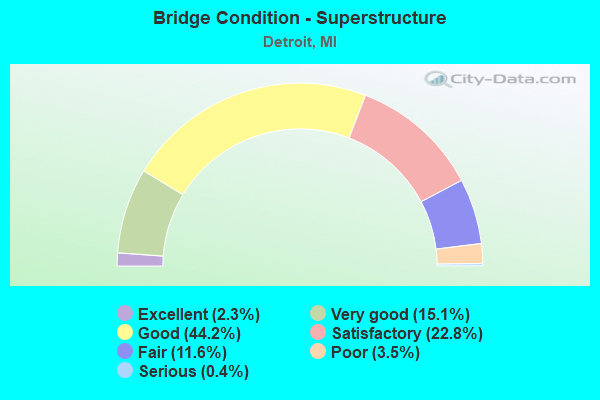
- Bridge Condition - Superstructure
- 2.3%Excellent
- 15.1%Very good
- 44.2%Good
- 22.8%Satisfactory
- 11.6%Fair
- 3.5%Poor
- 0.4%Serious
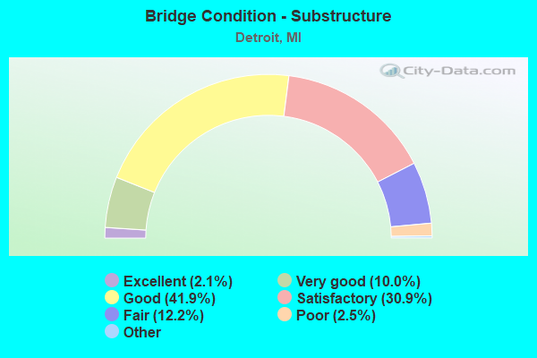
- Bridge Condition - Substructure
- 2.1%Excellent
- 10.0%Very good
- 41.9%Good
- 30.9%Satisfactory
- 12.2%Fair
- 2.5%Poor
- 0.4%Serious
- 0.2%Failed
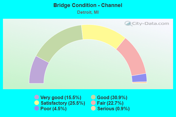
- Bridge Condition - Channel
- 15.5%Very good
- 30.9%Good
- 25.5%Satisfactory
- 22.7%Fair
- 4.5%Poor
- 0.9%Serious
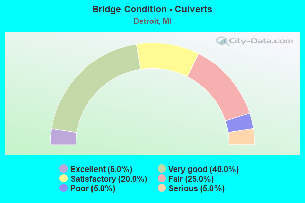
- Bridge Condition - Culverts
- 5.0%Excellent
- 40.0%Very good
- 20.0%Satisfactory
- 25.0%Fair
- 5.0%Poor
- 5.0%Serious
Find on map >> Show street view
Structure Number: 11733, Location: IN DETROIT (Lat: 42.278358, Lng: -83.153414), Route carried "on" structure: Interstate 75, Year Built: 1967, Year Reconstructed: 2002, Status: Open, Structure Length: 9.11m (29.89ft), Average Daily Traffic: 105,854 (year 2007), Truck Traffic: 12%, Average Future Daily Traffic: 104,504 (year 2018), Design Load: HS 25 or greater, Features Intersected: M-85 (FORT ST)
Minimum Vertical Clearance: 30.48m (100.00ft), Kilometerpoint: 26.378, Lanes on structure: 9, Lanes under structure: 8, Base Highway Network: Yes (Inventory Route: 159, Subroute: 10), Owner: State Highway Agency, Approaching Roadway Width: 35.9m (117.8ft), Skew: 35 degrees, Material/Design: Steel continuous, Design/Construction: Stringer/Multi-beam, Number Of Spans In Main Unit: 2, Number Of Approach Spans: 2, Length of Maximum Span: 32.9m (107.9ft), Curb-To-Curb Width: 44.8m (147.0ft), Out-to-Out Width: 46.8m (153.5ft)
Condition: Deck: Satisfactory, Superstructure: Very good, Substructure: Good, Operating Rating: 60.8 metric tons, Method Used To Determine Operating Rating: Load Factor (LF), Inventory Rating: 36.3 metric tons, Method Used To Determine Inventory Rating: Load Factor (LF), Structural Evaluation: Better than present minimum criteria, Deck Geometry: Superior to present desirable criteria, Underclear: Somewhat better than minimum adequacy, Approach Roadway Alignment: Equal to present desirable criteria, Designated Inspection Frequency: Every 24 months, Inspection Date: June 2021, Deck Structure Type: Concrete Cast-file-Place, Wearing Surface/Protective System: Wearing Surface: Monolithic Concrete, Deck Protection: Epoxy Coated Reinforcing
Find on map >> Show street view
Structure Number: 11734, Location: IN DETROIT (Lat: 42.298575, Lng: -83.123386), Route carried "on" structure: Interstate 75, Year Built: 1967, Year Reconstructed: 2018, Status: Open, Structure Length: 25.05m (82.19ft), Average Daily Traffic: 103,925 (year 2014), Truck Traffic: 12%, Average Future Daily Traffic: 116,550 (year 2037), Design Load: HS 20+Mod, Features Intersected: FORT ST
Minimum Vertical Clearance: 30.48m (100.00ft), Kilometerpoint: 29.850, Lanes on structure: 8, Lanes under structure: 6, Base Highway Network: Yes (Inventory Route: 159, Subroute: 10), Owner: State Highway Agency, Approaching Roadway Width: 42.6m (139.8ft), Skew: 36 degrees, Material/Design: Steel, Design/Construction: Stringer/Multi-beam, Number Of Spans In Main Unit: 10, Length of Maximum Span: 37.5m (123.0ft), Curb-To-Curb Width: 38.1m (125.0ft), Out-to-Out Width: 40.2m (131.9ft)
Condition: Deck: Good, Superstructure: Good, Substructure: Poor, Operating Rating: 74.5 metric tons, Method Used To Determine Operating Rating: Load Factor (LF) rating reported by rating factor (RF) method using MS18 loading, Inventory Rating: 44.7 metric tons, Method Used To Determine Inventory Rating: Load Factor (LF) rating reported by rating factor (RF) method using MS18 loading, Structural Evaluation: Meets minimum limits, Deck Geometry: Superior to present desirable criteria, Underclear: Equal to present minimum criteria, Approach Roadway Alignment: Equal to present desirable criteria, Designated Inspection Frequency: Every 24 months, Other Special Inspection Frequency: Every 15 months, Inspection Date: May 2020, Other Special Inspection Date: Febuary 2021, Bridge Improvement Cost: $828,000, Deck Structure Type: Concrete Cast-file-Place, Wearing Surface/Protective System: Wearing Surface: Monolithic Concrete, Deck Protection: Epoxy Coated Reinforcing
Find on map >> Show street view
Structure Number: 11735, Location: IN DETROIT (Lat: 42.301300, Lng: -83.119333), Route carried "on" structure: City street 2000, Year Built: 2021, Status: Open, Structure Length: 4.97m (16.31ft), Average Daily Traffic: 14,137 (year 2010), Truck Traffic: 3%, Average Future Daily Traffic: 15,551 (year 2025), Design Load: Greater than HL93, Features Intersected: I-75, Facility Carried by Structure: SPRINGWELLS AVE
Minimum Vertical Clearance: 30.48m (100.00ft), Kilometerpoint: 1.259, Lanes on structure: 4, Lanes under structure: 8, Owner: State Highway Agency, Approaching Roadway Width: 23.7m (77.8ft), Material/Design: Prestressed concrete, Design/Construction: Stringer/Multi-beam, Number Of Spans In Main Unit: 2, Length of Maximum Span: 26.1m (85.6ft), Curb or Sidewalk Widths: Left: 5.6m (18.4ft), Right: 7.5m (24.6ft), Curb-To-Curb Width: 15.5m (50.9ft), Out-to-Out Width: 29.5m (96.8ft)
Condition: Deck: Excellent, Superstructure: Excellent, Substructure: Excellent, Operating Rating: 61.6 metric tons, Method Used To Determine Operating Rating: Load and Resistance Factor Rating (LRFR) rating reported by rating factor(RF) method using HL-93 loadings, Inventory Rating: 44.1 metric tons, Method Used To Determine Inventory Rating: Load and Resistance Factor Rating (LRFR) rating reported by rating factor(RF) method using HL-93 loadings, Structural Evaluation: Superior to present desirable criteria, Deck Geometry: Meets minimum limits, Underclear: High priority of corrective action, Approach Roadway Alignment: Equal to present desirable criteria, Designated Inspection Frequency: Every 18 months, Inspection Date: December 2021, Deck Structure Type: Concrete Cast-file-Place, Wearing Surface/Protective System: Wearing Surface: Monolithic Concrete, Deck Protection: Epoxy Coated Reinforcing
Find on map >> Show street view
Structure Number: 11736, Location: IN DETROIT (Lat: 42.303475, Lng: -83.113814), Route carried "on" structure: City street , Year Built: 1967, Status: Open, Structure Length: 8.84m (29.00ft), Average Daily Traffic: 5,600 (year 1991), Truck Traffic: 4%, Average Future Daily Traffic: 7,000 (year 2015), Design Load: HS 20, Features Intersected: I-75, Facility Carried by Structure: GREEN AVE
Minimum Vertical Clearance: 30.48m (100.00ft), Kilometerpoint: 1.080, Lanes on structure: 4, Lanes under structure: 8, Owner: State Highway Agency, Approaching Roadway Width: 19.5m (64.0ft), Material/Design: Steel continuous, Design/Construction: Stringer/Multi-beam, Number Of Spans In Main Unit: 4, Length of Maximum Span: 22.8m (74.8ft), Curb or Sidewalk Widths: Left: 3.0m (9.8ft), Right: 3.0m (9.8ft), Curb-To-Curb Width: 13.4m (44.0ft), Out-to-Out Width: 20.2m (66.3ft)
Condition: Deck: Satisfactory, Superstructure: Satisfactory, Substructure: Satisfactory, Operating Rating: 55.1 metric tons, Method Used To Determine Operating Rating: Load Factor (LF) rating reported by rating factor (RF) method using MS18 loading, Inventory Rating: 33.0 metric tons, Method Used To Determine Inventory Rating: Load Factor (LF) rating reported by rating factor (RF) method using MS18 loading, Structural Evaluation: Equal to present minimum criteria, Deck Geometry: High priority of replacement, Underclear: High priority of replacement, Approach Roadway Alignment: Equal to present desirable criteria, Designated Inspection Frequency: Every 24 months, Inspection Date: June 2021, Bridge Improvement Cost: $1,648,000, Deck Structure Type: Concrete Cast-file-Place, Wearing Surface/Protective System: Wearing Surface: Epoxy Overlay
Find on map >> Show street view
Structure Number: 11737, Location: IN DETROIT (Lat: 42.305411, Lng: -83.109003), Route carried "on" structure: City street , Year Built: 1967, Status: Open, Structure Length: 9.45m (31.00ft), Average Daily Traffic: 1,772 (year 2010), Truck Traffic: 3%, Average Future Daily Traffic: 1,949 (year 2025), Design Load: HS 20, Features Intersected: I-75, Facility Carried by Structure: WATERMAN AVE
Minimum Vertical Clearance: 30.48m (100.00ft), Kilometerpoint: 1.064, Lanes on structure: 4, Lanes under structure: 8, Owner: State Highway Agency, Approaching Roadway Width: 14.6m (47.9ft), Material/Design: Steel continuous, Design/Construction: Stringer/Multi-beam, Number Of Spans In Main Unit: 4, Length of Maximum Span: 23.7m (77.8ft), Curb or Sidewalk Widths: Left: 3.0m (9.8ft), Right: 3.0m (9.8ft), Curb-To-Curb Width: 14.6m (47.9ft), Out-to-Out Width: 21.4m (70.2ft)
Condition: Deck: Satisfactory, Superstructure: Fair, Substructure: Satisfactory, Operating Rating: 60.3 metric tons, Method Used To Determine Operating Rating: Load Factor (LF) rating reported by rating factor (RF) method using MS18 loading, Inventory Rating: 36.0 metric tons, Method Used To Determine Inventory Rating: Load Factor (LF) rating reported by rating factor (RF) method using MS18 loading, Structural Evaluation: Somewhat better than minimum adequacy, Deck Geometry: High priority of replacement, Underclear: High priority of corrective action, Approach Roadway Alignment: Equal to present desirable criteria, Designated Inspection Frequency: Every 24 months, Inspection Date: June 2021, Bridge Improvement Cost: $349,000, Deck Structure Type: Concrete Cast-file-Place, Wearing Surface/Protective System: Wearing Surface: Epoxy Overlay
Find on map >> Show street view
Structure Number: 11738, Location: IN DETROIT (Lat: 42.307561, Lng: -83.104139), Route carried "on" structure: City street 2000, Year Built: 2021, Status: Open, Structure Length: 6.39m (20.96ft), Average Daily Traffic: 1,592 (year 2010), Truck Traffic: 3%, Average Future Daily Traffic: 1,751 (year 2025), Design Load: Greater than HL93, Features Intersected: I-75, Facility Carried by Structure: LIVERNOIS AVE
Minimum Vertical Clearance: 30.48m (100.00ft), Kilometerpoint: 0.922, Lanes on structure: 4, Lanes under structure: 10, Base Highway Network: Yes (Inventory Route: 158, Subroute: 1), Owner: State Highway Agency, Approaching Roadway Width: 14.6m (47.9ft), Material/Design: Prestressed concrete, Design/Construction: Stringer/Multi-beam, Number Of Spans In Main Unit: 2, Length of Maximum Span: 33.6m (110.2ft), Curb or Sidewalk Widths: Left: 8.1m (26.6ft), Right: 8.1m (26.6ft), Curb-To-Curb Width: 15.1m (49.5ft), Out-to-Out Width: 32.1m (105.3ft)
Condition: Deck: Excellent, Superstructure: Excellent, Substructure: Excellent, Operating Rating: 74.8 metric tons, Method Used To Determine Operating Rating: Load and Resistance Factor Rating (LRFR) rating reported by rating factor(RF) method using HL-93 loadings, Inventory Rating: 40.5 metric tons, Method Used To Determine Inventory Rating: Load and Resistance Factor Rating (LRFR) rating reported by rating factor(RF) method using HL-93 loadings, Structural Evaluation: Superior to present desirable criteria, Deck Geometry: High priority of corrective action, Underclear: High priority of corrective action, Approach Roadway Alignment: Equal to present desirable criteria, Designated Inspection Frequency: Every 19 months, Inspection Date: November 2021, Deck Structure Type: Concrete Cast-file-Place, Wearing Surface/Protective System: Wearing Surface: Monolithic Concrete, Deck Protection: Epoxy Coated Reinforcing
Find on map >> Show street view
Structure Number: 11739, Location: IN DETROIT (Lat: 42.311117, Lng: -83.097008), Route carried "on" structure: City street , Year Built: 1968, Status: Open, Structure Length: 4.63m (15.19ft), Average Daily Traffic: 1,397 (year 2010), Truck Traffic: 3%, Average Future Daily Traffic: 1,537 (year 2025), Design Load: HS 20+Mod, Features Intersected: I-75, Facility Carried by Structure: JUNCTION AVE
Minimum Vertical Clearance: 30.48m (100.00ft), Kilometerpoint: 0.929, Lanes on structure: 4, Lanes under structure: 8, Owner: State Highway Agency, Approaching Roadway Width: 14.6m (47.9ft), Material/Design: Steel continuous, Design/Construction: Stringer/Multi-beam, Number Of Spans In Main Unit: 2, Length of Maximum Span: 23.1m (75.8ft), Curb or Sidewalk Widths: Left: 3.0m (9.8ft), Right: 3.0m (9.8ft), Curb-To-Curb Width: 14.6m (47.9ft), Out-to-Out Width: 21.4m (70.2ft)
Condition: Deck: Fair, Superstructure: Good, Substructure: Satisfactory, Operating Rating: 61.9 metric tons, Method Used To Determine Operating Rating: Load Factor (LF) rating reported by rating factor (RF) method using MS18 loading, Inventory Rating: 36.9 metric tons, Method Used To Determine Inventory Rating: Load Factor (LF) rating reported by rating factor (RF) method using MS18 loading, Structural Evaluation: Equal to present minimum criteria, Deck Geometry: High priority of replacement, Underclear: High priority of corrective action, Approach Roadway Alignment: Equal to present desirable criteria, Length Of Structure Improvement: 4.63m (15.19ft), Designated Inspection Frequency: Every 24 months, Inspection Date: June 2021, Bridge Improvement Cost: $170,000, Roadway Improvement Cost: $9,000, Total Project Cost: $102,000, Deck Structure Type: Concrete Cast-file-Place, Wearing Surface/Protective System: Wearing Surface: Latex Concrete
Find on map >> Show street view
Structure Number: 1174, Location: IN DETROIT (Lat: 42.313469, Lng: -83.090944), Route carried "on" structure: City street 2000, Year Built: 1970, Status: Closed, Structure Length: 4.66m (15.29ft), Average Daily Traffic: 19,076 (year 2010), Truck Traffic: 3%, Average Future Daily Traffic: 20,984 (year 2025), Design Load: HS 20, Features Intersected: I-75, Facility Carried by Structure: CLARK AVE
Minimum Vertical Clearance: 30.48m (100.00ft), Kilometerpoint: 2.235, Lanes on structure: 6, Lanes under structure: 8, Owner: State Highway Agency, Approaching Roadway Width: 17.6m (57.7ft), Skew: 30 degrees, Material/Design: Steel continuous, Design/Construction: Stringer/Multi-beam, Number Of Spans In Main Unit: 2, Length of Maximum Span: 23.1m (75.8ft), Curb or Sidewalk Widths: Left: 0.7m (2.3ft), Right: 0.7m (2.3ft), Curb-To-Curb Width: 33.5m (109.9ft), Out-to-Out Width: 35.7m (117.1ft)
Condition: Deck: Fair, Superstructure: Good, Substructure: Satisfactory, Operating Rating: 48.6 metric tons, Method Used To Determine Operating Rating: Load Factor (LF) rating reported by rating factor (RF) method using MS18 loading, Inventory Rating: 29.2 metric tons, Method Used To Determine Inventory Rating: Load Factor (LF) rating reported by rating factor (RF) method using MS18 loading, Structural Evaluation: Equal to present minimum criteria, Deck Geometry: Superior to present desirable criteria, Approach Roadway Alignment: Equal to present desirable criteria, Length Of Structure Improvement: 4.66m (15.29ft), Designated Inspection Frequency: Every 24 months, Inspection Date: June 2021, Bridge Improvement Cost: $265,000, Roadway Improvement Cost: $13,000, Total Project Cost: $157,000, Deck Structure Type: Concrete Cast-file-Place, Wearing Surface/Protective System: Wearing Surface: Latex Concrete
Find on map >> Show street view
Structure Number: 11741, Location: IN DETROIT (Lat: 42.316144, Lng: -83.084519), Route carried "on" structure: City street 2000, Year Built: 2003, Status: Open, Structure Length: 6.02m (19.75ft), Average Daily Traffic: 4,235 (year 0000), Truck Traffic: 17%, Average Future Daily Traffic: 82,600 (year 2023), Design Load: HS 20, Features Intersected: I-75, Facility Carried by Structure: W GRAND BLVD SB
Minimum Vertical Clearance: 30.48m (100.00ft), Kilometerpoint: 0.473, Lanes on structure: 3, Lanes under structure: 10, Owner: State Highway Agency, Approaching Roadway Width: 11.2m (36.7ft), Skew: 11 degrees, Material/Design: Steel continuous, Design/Construction: Stringer/Multi-beam, Number Of Spans In Main Unit: 2, Length of Maximum Span: 32.2m (105.6ft), Curb or Sidewalk Widths: Left: 0.0m, Right: 3.0m (9.8ft), Curb-To-Curb Width: 11.1m (36.4ft), Out-to-Out Width: 14.8m (48.6ft)
Condition: Deck: Good, Superstructure: Very good, Substructure: Good, Operating Rating: 97.6 metric tons, Method Used To Determine Operating Rating: Load Factor (LF), Inventory Rating: 58.5 metric tons, Method Used To Determine Inventory Rating: Load Factor (LF), Structural Evaluation: Better than present minimum criteria, Deck Geometry: High priority of replacement, Underclear: Somewhat better than minimum adequacy, Approach Roadway Alignment: Equal to present desirable criteria, Designated Inspection Frequency: Every 24 months, Inspection Date: May 2020, Deck Structure Type: Concrete Cast-file-Place, Wearing Surface/Protective System: Wearing Surface: Monolithic Concrete, Deck Protection: Epoxy Coated Reinforcing
Find on map >> Show street view
Structure Number: 11746, Location: IN DETROIT (Lat: 42.325092, Lng: -83.083686), Route carried "on" structure: City street 2000, Year Built: 2007, Status: Open, Structure Length: 9.62m (31.56ft), Average Daily Traffic: 16,560 (year 2005), Truck Traffic: 3%, Average Future Daily Traffic: 16,560 (year 2015), Design Load: HS 20, Features Intersected: I-75, Facility Carried by Structure: VERNOR AVE
Minimum Vertical Clearance: 30.48m (100.00ft), Kilometerpoint: 5.419, Lanes on structure: 5, Lanes under structure: 11, Base Highway Network: Yes (Inventory Route: 158, Subroute: 9), Owner: State Highway Agency, Approaching Roadway Width: 17.7m (58.1ft), Material/Design: Steel continuous, Design/Construction: Stringer/Multi-beam, Number Of Spans In Main Unit: 4, Length of Maximum Span: 27.3m (89.6ft), Curb or Sidewalk Widths: Left: 3.0m (9.8ft), Right: 3.0m (9.8ft), Curb-To-Curb Width: 17.7m (58.1ft), Out-to-Out Width: 24.5m (80.4ft)
Condition: Deck: Good, Superstructure: Good, Substructure: Very good, Operating Rating: 82.3 metric tons, Method Used To Determine Operating Rating: Load Factor (LF) rating reported by rating factor (RF) method using MS18 loading, Inventory Rating: 49.2 metric tons, Method Used To Determine Inventory Rating: Load Factor (LF) rating reported by rating factor (RF) method using MS18 loading, Structural Evaluation: Better than present minimum criteria, Deck Geometry: High priority of replacement, Underclear: Meets minimum limits, Approach Roadway Alignment: Equal to present desirable criteria, Designated Inspection Frequency: Every 24 months, Inspection Date: November 2021, Deck Structure Type: Concrete Cast-file-Place, Wearing Surface/Protective System: Wearing Surface: Integral Concrete, Deck Protection: Epoxy Coated Reinforcing
Find on map >> Show street view
Structure Number: 11747, Location: IN DETROIT (Lat: 42.330169, Lng: -83.086486), Route carried "on" structure: Interstate 75, Year Built: 1970, Year Reconstructed: 2007, Status: Open, Structure Length: 1.57m (5.15ft), Average Daily Traffic: 33,794 (year 2007), Truck Traffic: 9%, Average Future Daily Traffic: 5,050 (year 2015), Design Load: HS 20, Features Intersected: I-96 WB
Minimum Vertical Clearance: 30.48m (100.00ft), Kilometerpoint: 35.286, Lanes on structure: 3, Lanes under structure: 2, Base Highway Network: Yes (Inventory Route: 159, Subroute: 6), Owner: State Highway Agency, Approaching Roadway Width: 17.0m (55.8ft), Skew: 7 degrees, Material/Design: Steel, Design/Construction: Stringer/Multi-beam, Number Of Spans In Main Unit: 1, Length of Maximum Span: 15.7m (51.5ft), Curb-To-Curb Width: 17.1m (56.1ft), Out-to-Out Width: 18.0m (59.1ft)
Condition: Deck: Very good, Superstructure: Very good, Substructure: Good, Operating Rating: 86.8 metric tons, Method Used To Determine Operating Rating: Load Factor (LF) rating reported by rating factor (RF) method using MS18 loading, Inventory Rating: 51.8 metric tons, Method Used To Determine Inventory Rating: Load Factor (LF) rating reported by rating factor (RF) method using MS18 loading, Structural Evaluation: Better than present minimum criteria, Deck Geometry: Equal to present minimum criteria, Underclear: High priority of corrective action, Approach Roadway Alignment: Better than present minimum criteria, Designated Inspection Frequency: Every 24 months, Inspection Date: May 2020, Deck Structure Type: Concrete Cast-file-Place, Wearing Surface/Protective System: Wearing Surface: Monolithic Concrete, Deck Protection: Epoxy Coated Reinforcing
Find on map >> Show street view
Structure Number: 11748, Location: IN DETROIT (Lat: 42.331478, Lng: -83.084561), Route carried "on" structure: US 12, Year Built: 1970, Year Reconstructed: 1998, Status: Open, Structure Length: 6.98m (22.90ft), Average Daily Traffic: 13,147 (year 2007), Truck Traffic: 10%, Average Future Daily Traffic: 12,175 (year 2018), Design Load: HS 20, Features Intersected: I-75 NB
Minimum Vertical Clearance: 30.48m (100.00ft), Kilometerpoint: 9.008, Lanes on structure: 8, Lanes under structure: 3, Base Highway Network: Yes (Inventory Route: 157, Subroute: 3), Owner: State Highway Agency, Approaching Roadway Width: 27.4m (89.9ft), Skew: 4 degrees, Material/Design: Steel, Design/Construction: Stringer/Multi-beam, Number Of Spans In Main Unit: 3, Length of Maximum Span: 32.6m (107.0ft), Curb or Sidewalk Widths: Left: 3.0m (9.8ft), Right: 3.0m (9.8ft), Curb-To-Curb Width: 28.6m (93.8ft), Out-to-Out Width: 34.5m (113.2ft)
Condition: Deck: Good, Superstructure: Satisfactory, Substructure: Fair, Operating Rating: 61.6 metric tons, Method Used To Determine Operating Rating: Load Factor (LF) rating reported by rating factor (RF) method using MS18 loading, Inventory Rating: 36.9 metric tons, Method Used To Determine Inventory Rating: Load Factor (LF) rating reported by rating factor (RF) method using MS18 loading, Structural Evaluation: Somewhat better than minimum adequacy, Deck Geometry: High priority of replacement, Underclear: High priority of corrective action, Approach Roadway Alignment: Equal to present desirable criteria, Designated Inspection Frequency: Every 24 months, Inspection Date: May 2020, Deck Structure Type: Concrete Cast-file-Place, Wearing Surface/Protective System: Wearing Surface: Monolithic Concrete
Find on map >> Show street view
Structure Number: 11749, Location: IN DETROIT (Lat: 42.331461, Lng: -83.085794), Route carried "on" structure: US 12, Year Built: 1970, Year Reconstructed: 1998, Status: Open, Structure Length: 5.73m (18.80ft), Average Daily Traffic: 11,831 (year 2007), Truck Traffic: 10%, Average Future Daily Traffic: 13,037 (year 2018), Design Load: HS 20+Mod, Features Intersected: I-75 SB
Minimum Vertical Clearance: 30.48m (100.00ft), Kilometerpoint: 8.906, Lanes on structure: 8, Lanes under structure: 3, Base Highway Network: Yes (Inventory Route: 157, Subroute: 3), Owner: State Highway Agency, Approaching Roadway Width: 27.4m (89.9ft), Skew: 3 degrees, Material/Design: Steel, Design/Construction: Stringer/Multi-beam, Number Of Spans In Main Unit: 3, Length of Maximum Span: 25.0m (82.0ft), Curb or Sidewalk Widths: Left: 3.0m (9.8ft), Right: 3.0m (9.8ft), Curb-To-Curb Width: 28.6m (93.8ft), Out-to-Out Width: 34.2m (112.2ft)
Condition: Deck: Good, Superstructure: Good, Substructure: Satisfactory, Operating Rating: 72.9 metric tons, Method Used To Determine Operating Rating: Load Factor (LF) rating reported by rating factor (RF) method using MS18 loading, Inventory Rating: 36.9 metric tons, Method Used To Determine Inventory Rating: Load Factor (LF) rating reported by rating factor (RF) method using MS18 loading, Structural Evaluation: Equal to present minimum criteria, Deck Geometry: High priority of replacement, Underclear: High priority of corrective action, Approach Roadway Alignment: Equal to present desirable criteria, Designated Inspection Frequency: Every 24 months, Inspection Date: May 2020, Deck Structure Type: Concrete Cast-file-Place, Wearing Surface/Protective System: Wearing Surface: Monolithic Concrete
Find on map >> Show street view
Structure Number: 1175, Location: IN DETROIT (Lat: 42.308189, Lng: -83.103003), Route carried "on" structure: City street 2000, Year Built: 1967, Status: Open, Structure Length: 7.01m (23.00ft), Average Daily Traffic: 2,173 (year 2010), Truck Traffic: 3%, Average Future Daily Traffic: 2,393 (year 2025), Design Load: HS 20, Features Intersected: I-75, Facility Carried by Structure: DRAGOON AVE
Minimum Vertical Clearance: 30.48m (100.00ft), Kilometerpoint: 0.884, Lanes on structure: 4, Lanes under structure: 8, Base Highway Network: Yes (Inventory Route: 159, Subroute: 7), Owner: State Highway Agency, Approaching Roadway Width: 14.6m (47.9ft), Material/Design: Steel continuous, Design/Construction: Stringer/Multi-beam, Number Of Spans In Main Unit: 4, Length of Maximum Span: 23.1m (75.8ft), Curb or Sidewalk Widths: Left: 3.0m (9.8ft), Right: 3.0m (9.8ft), Curb-To-Curb Width: 14.6m (47.9ft), Out-to-Out Width: 21.4m (70.2ft)
Condition: Deck: Poor, Superstructure: Satisfactory, Substructure: Fair, Operating Rating: 62.5 metric tons, Method Used To Determine Operating Rating: Load Factor (LF) rating reported by rating factor (RF) method using MS18 loading, Inventory Rating: 37.6 metric tons, Method Used To Determine Inventory Rating: Load Factor (LF) rating reported by rating factor (RF) method using MS18 loading, Structural Evaluation: Somewhat better than minimum adequacy, Deck Geometry: High priority of replacement, Underclear: Meets minimum limits, Approach Roadway Alignment: Equal to present desirable criteria, Designated Inspection Frequency: Every 12 months, Inspection Date: May 2021, Deck Structure Type: Concrete Cast-file-Place, Wearing Surface/Protective System: Wearing Surface: Latex Concrete
Find on map >> Show street view
Structure Number: 11751, Location: IN DETROIT (Lat: 42.332964, Lng: -83.083972), Route carried "on" structure: Ramp Interstate 75, Year Built: 1970, Year Reconstructed: 2007, Status: Open, Structure Length: 6.17m (20.24ft), Average Daily Traffic: 13,830 (year 1982), Truck Traffic: 3%, Average Future Daily Traffic: 13,830 (year 2024), Design Load: HS 20+Mod, Features Intersected: RAMP TO WB I-96
Minimum Vertical Clearance: 30.48m (100.00ft), Kilometerpoint: 0.132, Lanes on structure: 1, Lanes under structure: 1, Owner: State Highway Agency, Approaching Roadway Width: 7.9m (25.9ft), Skew: 6 degrees, Material/Design: Steel, Design/Construction: Stringer/Multi-beam, Number Of Spans In Main Unit: 3, Length of Maximum Span: 24.4m (80.1ft), Curb-To-Curb Width: 8.5m (27.9ft), Out-to-Out Width: 9.5m (31.2ft)
Condition: Deck: Good, Superstructure: Good, Substructure: Satisfactory, Operating Rating: 82.6 metric tons, Method Used To Determine Operating Rating: Load Factor (LF) rating reported by rating factor (RF) method using MS18 loading, Inventory Rating: 49.6 metric tons, Method Used To Determine Inventory Rating: Load Factor (LF) rating reported by rating factor (RF) method using MS18 loading, Structural Evaluation: Equal to present minimum criteria, Deck Geometry: Superior to present desirable criteria, Underclear: High priority of corrective action, Approach Roadway Alignment: Equal to present minimum criteria, Designated Inspection Frequency: Every 24 months, Inspection Date: May 2020, Bridge Improvement Cost: $85,000, Deck Structure Type: Concrete Cast-file-Place, Wearing Surface/Protective System: Wearing Surface: Monolithic Concrete, Deck Protection: Epoxy Coated Reinforcing
Find on map >> Show street view
Structure Number: 11752, Location: IN DETROIT (Lat: 42.316311, Lng: -83.084281), Route carried "on" structure: City street 2000, Year Built: 2003, Status: Open, Structure Length: 6.28m (20.60ft), Average Daily Traffic: 4,000 (year 1991), Truck Traffic: 17%, Average Future Daily Traffic: 82,600 (year 2023), Design Load: HS 20, Features Intersected: I-75, Facility Carried by Structure: W GRAND BLVD NB
Minimum Vertical Clearance: 30.48m (100.00ft), Kilometerpoint: 0.455, Lanes on structure: 3, Lanes under structure: 10, Base Highway Network: Yes (Inventory Route: 158, Subroute: 3), Owner: State Highway Agency, Approaching Roadway Width: 11.2m (36.7ft), Skew: 11 degrees, Material/Design: Steel continuous, Design/Construction: Stringer/Multi-beam, Number Of Spans In Main Unit: 2, Length of Maximum Span: 32.9m (107.9ft), Curb or Sidewalk Widths: Left: 0.0m, Right: 3.0m (9.8ft), Curb-To-Curb Width: 11.1m (36.4ft), Out-to-Out Width: 14.8m (48.6ft)
Condition: Deck: Good, Superstructure: Very good, Substructure: Good, Operating Rating: 87.5 metric tons, Method Used To Determine Operating Rating: Load Factor (LF), Inventory Rating: 52.4 metric tons, Method Used To Determine Inventory Rating: Load Factor (LF), Structural Evaluation: Better than present minimum criteria, Deck Geometry: High priority of replacement, Underclear: Somewhat better than minimum adequacy, Approach Roadway Alignment: Equal to present desirable criteria, Designated Inspection Frequency: Every 24 months, Inspection Date: May 2020, Deck Structure Type: Concrete Cast-file-Place, Wearing Surface/Protective System: Wearing Surface: Monolithic Concrete, Deck Protection: Epoxy Coated Reinforcing
Find on map >> Show street view
Structure Number: 11753, Location: IN DETROIT (Lat: 42.331458, Lng: -83.086853), Route carried "on" structure: US 12, Year Built: 1970, Year Reconstructed: 2005, Status: Open, Structure Length: 7.76m (25.46ft), Average Daily Traffic: 11,831 (year 2007), Truck Traffic: 10%, Average Future Daily Traffic: 13,037 (year 2018), Design Load: HS 20, Features Intersected: I-96
Minimum Vertical Clearance: 30.48m (100.00ft), Kilometerpoint: 8.781, Lanes on structure: 8, Lanes under structure: 4, Base Highway Network: Yes (Inventory Route: 157, Subroute: 3), Owner: State Highway Agency, Approaching Roadway Width: 28.6m (93.8ft), Skew: 1 degrees, Material/Design: Steel continuous, Design/Construction: Stringer/Multi-beam, Number Of Spans In Main Unit: 5, Length of Maximum Span: 22.1m (72.5ft), Curb or Sidewalk Widths: Left: 2.4m (7.9ft), Right: 2.4m (7.9ft), Curb-To-Curb Width: 28.7m (94.2ft), Out-to-Out Width: 34.5m (113.2ft)
Condition: Deck: Good, Superstructure: Satisfactory, Substructure: Satisfactory, Operating Rating: 69.0 metric tons, Method Used To Determine Operating Rating: Load Factor (LF) rating reported by rating factor (RF) method using MS18 loading, Inventory Rating: 41.1 metric tons, Method Used To Determine Inventory Rating: Load Factor (LF) rating reported by rating factor (RF) method using MS18 loading, Structural Evaluation: Equal to present minimum criteria, Deck Geometry: High priority of corrective action, Underclear: High priority of corrective action, Approach Roadway Alignment: Equal to present desirable criteria, Designated Inspection Frequency: Every 24 months, Inspection Date: May 2020, Deck Structure Type: Concrete Cast-file-Place, Wearing Surface/Protective System: Wearing Surface: Monolithic Concrete, Deck Protection: Epoxy Coated Reinforcing
Find on map >> Show street view
Structure Number: 11754, Location: IN DETROIT (Lat: 42.332000, Lng: -83.085306), Route carried "on" structure: Ramp Interstate 96, Year Built: 1970, Status: Open, Structure Length: 5.45m (17.88ft), Average Daily Traffic: 33,794 (year 2007), Truck Traffic: 9%, Average Future Daily Traffic: 35,218 (year 2018), Design Load: HS 20+Mod, Features Intersected: I-75 SB & ENTRANCE RAMP
Minimum Vertical Clearance: 30.48m (100.00ft), Kilometerpoint: 0.660, Lanes on structure: 2, Lanes under structure: 3, Owner: State Highway Agency, Approaching Roadway Width: 9.4m (30.8ft), Skew: 3 degrees, Material/Design: Steel, Design/Construction: Stringer/Multi-beam, Number Of Spans In Main Unit: 3, Length of Maximum Span: 26.5m (86.9ft), Curb-To-Curb Width: 11.7m (38.4ft), Out-to-Out Width: 12.4m (40.7ft)
Condition: Deck: Fair, Superstructure: Satisfactory, Substructure: Satisfactory, Operating Rating: 86.2 metric tons, Method Used To Determine Operating Rating: Load Factor (LF) rating reported by rating factor (RF) method using MS18 loading, Inventory Rating: 51.5 metric tons, Method Used To Determine Inventory Rating: Load Factor (LF) rating reported by rating factor (RF) method using MS18 loading, Structural Evaluation: Equal to present minimum criteria, Deck Geometry: Superior to present desirable criteria, Underclear: High priority of corrective action, Approach Roadway Alignment: Equal to present minimum criteria, Designated Inspection Frequency: Every 24 months, Inspection Date: June 2020, Deck Structure Type: Concrete Cast-file-Place, Wearing Surface/Protective System: Wearing Surface: Integral Concrete
Find on map >> Show street view
Structure Number: 11755, Location: IN DETROIT (Lat: 42.331833, Lng: -83.083833), Route carried "on" structure: Ramp Interstate 96, Year Built: 1970, Status: Open, Structure Length: 8.14m (26.71ft), Average Daily Traffic: 10,290 (year 1982), Truck Traffic: 3%, Average Future Daily Traffic: 6,400 (year 2026), Design Load: HS 20+Mod, Features Intersected: I-75 NB AND EXIT RAMP
Minimum Vertical Clearance: 30.48m (100.00ft), Kilometerpoint: 0.042, Lanes on structure: 1, Lanes under structure: 3, Owner: State Highway Agency, Approaching Roadway Width: 4.8m (15.7ft), Skew: 5 degrees, Material/Design: Steel, Design/Construction: Stringer/Multi-beam, Number Of Spans In Main Unit: 3, Length of Maximum Span: 38.1m (125.0ft), Curb-To-Curb Width: 7.6m (24.9ft), Out-to-Out Width: 8.5m (27.9ft)
Condition: Deck: Satisfactory, Superstructure: Satisfactory, Substructure: Satisfactory, Operating Rating: 76.8 metric tons, Method Used To Determine Operating Rating: Load Factor (LF) rating reported by rating factor (RF) method using MS18 loading, Inventory Rating: 46.0 metric tons, Method Used To Determine Inventory Rating: Load Factor (LF) rating reported by rating factor (RF) method using MS18 loading, Structural Evaluation: Equal to present minimum criteria, Deck Geometry: Better than present minimum criteria, Underclear: Meets minimum limits, Approach Roadway Alignment: Equal to present desirable criteria, Designated Inspection Frequency: Every 24 months, Inspection Date: June 2020, Deck Structure Type: Concrete Cast-file-Place, Wearing Surface/Protective System: Wearing Surface: Latex Concrete
Find on map >> Show street view
Structure Number: 11756, Location: IN DETROIT (Lat: 42.332733, Lng: -83.087222), Route carried "on" structure: Ramp Interstate 75, Year Built: 1970, Year Reconstructed: 2007, Status: Open, Structure Length: 5.12m (16.80ft), Average Daily Traffic: 179,000 (year 2005), Truck Traffic: 3%, Average Future Daily Traffic: 205,850 (year 2025), Design Load: HS 20, Features Intersected: I-96 WB
Minimum Vertical Clearance: 30.48m (100.00ft), Kilometerpoint: 0.367, Lanes on structure: 2, Lanes under structure: 2, Owner: State Highway Agency, Approaching Roadway Width: 13.1m (43.0ft), Skew: 4 degrees, Material/Design: Steel, Design/Construction: Stringer/Multi-beam, Number Of Spans In Main Unit: 3, Length of Maximum Span: 24.0m (78.7ft), Curb-To-Curb Width: 12.2m (40.0ft), Out-to-Out Width: 13.1m (43.0ft)
Condition: Deck: Good, Superstructure: Good, Substructure: Satisfactory, Operating Rating: 97.2 metric tons, Method Used To Determine Operating Rating: Load Factor (LF) rating reported by rating factor (RF) method using MS18 loading, Inventory Rating: 61.6 metric tons, Method Used To Determine Inventory Rating: Load Factor (LF) rating reported by rating factor (RF) method using MS18 loading, Structural Evaluation: Equal to present minimum criteria, Deck Geometry: Superior to present desirable criteria, Underclear: High priority of corrective action, Approach Roadway Alignment: Equal to present desirable criteria, Length Of Structure Improvement: 5.12m (16.80ft), Designated Inspection Frequency: Every 24 months, Inspection Date: June 2020, Bridge Improvement Cost: $192,000, Roadway Improvement Cost: $15,000, Total Project Cost: $178,000, Deck Structure Type: Concrete Cast-file-Place, Wearing Surface/Protective System: Wearing Surface: Monolithic Concrete, Deck Protection: Epoxy Coated Reinforcing
Find on map >> Show street view
Structure Number: 1176, Location: IN DETROIT (Lat: 42.332169, Lng: -83.076947), Route carried "on" structure: City street 2000, Year Built: 1970, Year Reconstructed: 1994, Status: Open, Structure Length: 10.05m (32.97ft), Average Daily Traffic: 15,000 (year 1991), Truck Traffic: 6%, Average Future Daily Traffic: 18,500 (year 2015), Design Load: HS 20, Features Intersected: I-75, Facility Carried by Structure: 14TH ST
Minimum Vertical Clearance: 30.48m (100.00ft), Kilometerpoint: 0.684, Lanes on structure: 5, Lanes under structure: 11, Base Highway Network: Yes (Inventory Route: 470, Subroute: 1), Owner: State Highway Agency, Approaching Roadway Width: 17.6m (57.7ft), Skew: 2 degrees, Material/Design: Steel, Design/Construction: Stringer/Multi-beam, Number Of Spans In Main Unit: 6, Length of Maximum Span: 20.7m (67.9ft), Curb or Sidewalk Widths: Left: 3.0m (9.8ft), Right: 3.0m (9.8ft), Curb-To-Curb Width: 17.7m (58.1ft), Out-to-Out Width: 24.5m (80.4ft)
Condition: Deck: Fair, Superstructure: Satisfactory, Substructure: Good, Operating Rating: 60.6 metric tons, Method Used To Determine Operating Rating: Load Factor (LF) rating reported by rating factor (RF) method using MS18 loading, Inventory Rating: 36.3 metric tons, Method Used To Determine Inventory Rating: Load Factor (LF) rating reported by rating factor (RF) method using MS18 loading, Structural Evaluation: Equal to present minimum criteria, Deck Geometry: High priority of replacement, Underclear: High priority of corrective action, Approach Roadway Alignment: Equal to present desirable criteria, Designated Inspection Frequency: Every 24 months, Inspection Date: October 2020, Bridge Improvement Cost: $757,000, Deck Structure Type: Concrete Cast-file-Place, Wearing Surface/Protective System: Wearing Surface: Monolithic Concrete, Deck Protection: Epoxy Coated Reinforcing
Find on map >> Show street view
Structure Number: 11761, Location: IN DETROIT (Lat: 42.333139, Lng: -83.073011), Route carried "on" structure: City street 2000, Year Built: 1970, Year Reconstructed: 1998, Status: Open, Structure Length: 8.68m (28.48ft), Average Daily Traffic: 9,270 (year 1978), Truck Traffic: 3%, Average Future Daily Traffic: 9,270 (year 2010), Design Load: HS 20, Features Intersected: I-75, Facility Carried by Structure: ROSA PARKS (12TH)
Minimum Vertical Clearance: 30.48m (100.00ft), Kilometerpoint: 1.416, Lanes on structure: 5, Lanes under structure: 10, Owner: State Highway Agency, Approaching Roadway Width: 20.7m (67.9ft), Skew: 30 degrees, Material/Design: Steel continuous, Design/Construction: Stringer/Multi-beam, Number Of Spans In Main Unit: 6, Length of Maximum Span: 19.2m (63.0ft), Curb or Sidewalk Widths: Left: 0.7m (2.3ft), Right: 3.0m (9.8ft), Curb-To-Curb Width: 22.5m (73.8ft), Out-to-Out Width: 27.1m (88.9ft)
Condition: Deck: Fair, Superstructure: Good, Substructure: Satisfactory, Operating Rating: 54.1 metric tons, Method Used To Determine Operating Rating: Load Factor (LF) rating reported by rating factor (RF) method using MS18 loading, Inventory Rating: 31.1 metric tons, Method Used To Determine Inventory Rating: Load Factor (LF) rating reported by rating factor (RF) method using MS18 loading, Structural Evaluation: Equal to present minimum criteria, Deck Geometry: Equal to present minimum criteria, Underclear: Meets minimum limits, Approach Roadway Alignment: Equal to present desirable criteria, Designated Inspection Frequency: Every 24 months, Inspection Date: May 2021, Deck Structure Type: Concrete Cast-file-Place, Wearing Surface/Protective System: Wearing Surface: Epoxy Overlay
Find on map >> Show street view
Structure Number: 11762, Location: IN DETROIT (Lat: 42.333428, Lng: -83.071278), Route carried "on" structure: Ramp City street 2000, Year Built: 1970, Year Reconstructed: 2003, Status: Open, Structure Length: 3.47m (11.38ft), Average Daily Traffic: 9,000 (year 1978), Truck Traffic: 3%, Average Future Daily Traffic: 9,000 (year 1977), Design Load: HS 20, Features Intersected: I-75 S COLLECTOR-DIST RD, Facility Carried by Structure: ROSA PARKS ENT RMP
Minimum Vertical Clearance: 30.48m (100.00ft), Kilometerpoint: 0.097, Lanes on structure: 1, Lanes under structure: 2, Owner: State Highway Agency, Approaching Roadway Width: 7.3m (24.0ft), Skew: 6 degrees, Material/Design: Steel, Design/Construction: Stringer/Multi-beam, Number Of Spans In Main Unit: 1, Length of Maximum Span: 34.7m (113.8ft), Curb or Sidewalk Widths: Left: 0.0m, Right: 3.0m (9.8ft), Curb-To-Curb Width: 7.4m (24.3ft), Out-to-Out Width: 8.2m (26.9ft)
Condition: Deck: Good, Superstructure: Good, Substructure: Good, Operating Rating: 97.2 metric tons, Method Used To Determine Operating Rating: Load Factor (LF) rating reported by rating factor (RF) method using MS18 loading, Inventory Rating: 59.3 metric tons, Method Used To Determine Inventory Rating: Load Factor (LF) rating reported by rating factor (RF) method using MS18 loading, Structural Evaluation: Better than present minimum criteria, Deck Geometry: Better than present minimum criteria, Underclear: Meets minimum limits, Approach Roadway Alignment: Better than present minimum criteria, Designated Inspection Frequency: Every 24 months, Inspection Date: May 2021, Deck Structure Type: Concrete Cast-file-Place, Wearing Surface/Protective System: Wearing Surface: Monolithic Concrete
Find on map >> Show street view
Structure Number: 11763, Location: IN DETROIT (Lat: 42.334383, Lng: -83.071011), Route carried "on" structure: Ramp City street 2000, Year Built: 1970, Year Reconstructed: 2003, Status: Open, Structure Length: 3.53m (11.58ft), Average Daily Traffic: 9,000 (year 1978), Truck Traffic: 3%, Average Future Daily Traffic: 9,000 (year 1977), Design Load: HS 20+Mod, Features Intersected: I-75 N COLLECTOR-DIST RD, Facility Carried by Structure: ROSA PARKS EXT RMP
Minimum Vertical Clearance: 30.48m (100.00ft), Kilometerpoint: 0.195, Lanes on structure: 1, Lanes under structure: 2, Owner: State Highway Agency, Approaching Roadway Width: 7.3m (24.0ft), Skew: 6 degrees, Material/Design: Steel, Design/Construction: Stringer/Multi-beam, Number Of Spans In Main Unit: 1, Length of Maximum Span: 35.3m (115.8ft), Curb or Sidewalk Widths: Left: 0.2m (0.7ft), Right: 0.2m (0.7ft), Curb-To-Curb Width: 7.4m (24.3ft), Out-to-Out Width: 8.2m (26.9ft)
Condition: Deck: Good, Superstructure: Good, Substructure: Satisfactory, Operating Rating: 71.6 metric tons, Method Used To Determine Operating Rating: Load Factor (LF) rating reported by rating factor (RF) method using MS18 loading, Inventory Rating: 36.3 metric tons, Method Used To Determine Inventory Rating: Load Factor (LF) rating reported by rating factor (RF) method using MS18 loading, Structural Evaluation: Equal to present minimum criteria, Deck Geometry: Better than present minimum criteria, Underclear: Somewhat better than minimum adequacy, Approach Roadway Alignment: Meets minimum limits, Designated Inspection Frequency: Every 24 months, Inspection Date: May 2021, Deck Structure Type: Concrete Cast-file-Place, Wearing Surface/Protective System: Wearing Surface: Monolithic Concrete
Find on map >> Show street view
Structure Number: 11764, Location: IN DETROIT (Lat: 42.334164, Lng: -83.068483), Route carried "on" structure: City street 2000, Year Built: 1970, Year Reconstructed: 1995, Status: Open, Structure Length: 10.07m (33.04ft), Average Daily Traffic: 17,830 (year 0000), Truck Traffic: 4%, Average Future Daily Traffic: 10,700 (year 2015), Design Load: HS 20, Features Intersected: I-75, Facility Carried by Structure: TRUMBULL AVE
Minimum Vertical Clearance: 30.48m (100.00ft), Kilometerpoint: 1.230, Lanes on structure: 6, Lanes under structure: 12, Owner: State Highway Agency, Approaching Roadway Width: 21.3m (69.9ft), Material/Design: Steel, Design/Construction: Stringer/Multi-beam, Number Of Spans In Main Unit: 6, Length of Maximum Span: 24.4m (80.1ft), Curb or Sidewalk Widths: Left: 4.6m (15.1ft), Right: 4.6m (15.1ft), Curb-To-Curb Width: 21.3m (69.9ft), Out-to-Out Width: 31.2m (102.4ft)
Condition: Deck: Satisfactory, Superstructure: Good, Substructure: Very good, Operating Rating: 53.1 metric tons, Method Used To Determine Operating Rating: Load Factor (LF) rating reported by rating factor (RF) method using MS18 loading, Inventory Rating: 31.8 metric tons, Method Used To Determine Inventory Rating: Load Factor (LF) rating reported by rating factor (RF) method using MS18 loading, Structural Evaluation: Better than present minimum criteria, Deck Geometry: High priority of replacement, Underclear: High priority of corrective action, Approach Roadway Alignment: Equal to present desirable criteria, Designated Inspection Frequency: Every 24 months, Inspection Date: October 2020, Deck Structure Type: Concrete Cast-file-Place, Wearing Surface/Protective System: Wearing Surface: Monolithic Concrete, Deck Protection: Epoxy Coated Reinforcing
Find on map >> Show street view
Structure Number: 11765, Location: IN DETROIT (Lat: 42.334942, Lng: -83.065742), Route carried "on" structure: Ramp State highway 10, Year Built: 1970, Status: Open, Structure Length: 7.37m (24.18ft), Average Daily Traffic: 11,370 (year 1982), Truck Traffic: 3%, Average Future Daily Traffic: 13,076 (year 2002), Design Load: HS 20+Mod, Features Intersected: I-75 & RAMP TO SB
Minimum Vertical Clearance: 30.48m (100.00ft), Kilometerpoint: 0.190, Lanes on structure: 1, Lanes under structure: 7, Owner: State Highway Agency, Approaching Roadway Width: 7.3m (24.0ft), Skew: 9 degrees, Material/Design: Steel, Design/Construction: Stringer/Multi-beam, Number Of Spans In Main Unit: 5, Length of Maximum Span: 19.5m (64.0ft), Curb or Sidewalk Widths: Left: 0.2m (0.7ft), Right: 0.2m (0.7ft), Curb-To-Curb Width: 8.2m (26.9ft), Out-to-Out Width: 8.9m (29.2ft)
Condition: Deck: Satisfactory, Superstructure: Good, Substructure: Satisfactory, Operating Rating: 65.8 metric tons, Method Used To Determine Operating Rating: Load Factor (LF) rating reported by rating factor (RF) method using MS18 loading, Inventory Rating: 39.2 metric tons, Method Used To Determine Inventory Rating: Load Factor (LF) rating reported by rating factor (RF) method using MS18 loading, Structural Evaluation: Equal to present minimum criteria, Deck Geometry: Superior to present desirable criteria, Underclear: High priority of corrective action, Approach Roadway Alignment: Equal to present minimum criteria, Designated Inspection Frequency: Every 24 months, Inspection Date: May 2021, Deck Structure Type: Concrete Cast-file-Place, Wearing Surface/Protective System: Wearing Surface: Monolithic Concrete
Find on map >> Show street view
Structure Number: 11766, Location: IN DETROIT (Lat: 42.333739, Lng: -83.063061), Route carried "on" structure: Ramp Interstate 75, Year Built: 1970, Year Reconstructed: 2017, Status: Open, Structure Length: 10.10m (33.14ft), Average Daily Traffic: 5,291 (year 2017), Truck Traffic: 3%, Average Future Daily Traffic: 6,225 (year 2037), Design Load: HS 20+Mod, Features Intersected: M-10
Minimum Vertical Clearance: 30.48m (100.00ft), Kilometerpoint: 0.142, Lanes on structure: 1, Lanes under structure: 9, Owner: State Highway Agency, Approaching Roadway Width: 8.2m (26.9ft), Skew: 9 degrees, Material/Design: Steel continuous, Design/Construction: Stringer/Multi-beam, Number Of Spans In Main Unit: 5, Length of Maximum Span: 25.8m (84.6ft), Curb-To-Curb Width: 8.5m (27.9ft), Out-to-Out Width: 9.5m (31.2ft)
Condition: Deck: Very good, Superstructure: Good, Substructure: Good, Operating Rating: 68.0 metric tons, Method Used To Determine Operating Rating: Load Factor (LF) rating reported by rating factor (RF) method using MS18 loading, Inventory Rating: 38.6 metric tons, Method Used To Determine Inventory Rating: Load Factor (LF) rating reported by rating factor (RF) method using MS18 loading, Structural Evaluation: Better than present minimum criteria, Deck Geometry: Superior to present desirable criteria, Underclear: High priority of corrective action, Approach Roadway Alignment: Equal to present minimum criteria, Designated Inspection Frequency: Every 24 months, Inspection Date: May 2020, Deck Structure Type: Concrete Cast-file-Place, Wearing Surface/Protective System: Wearing Surface: Monolithic Concrete, Deck Protection: Epoxy Coated Reinforcing
Find on map >> Show street view
Structure Number: 11767, Location: IN DETROIT (Lat: 42.334853, Lng: -83.063358), Route carried "on" structure: Ramp State highway 10, Year Built: 1970, Year Reconstructed: 1998, Status: Open, Structure Length: 12.16m (39.90ft), Average Daily Traffic: 10,500 (year 1982), Truck Traffic: 13%, Average Future Daily Traffic: 6,000 (year 2026), Design Load: HS 20+Mod, Features Intersected: M-10
Minimum Vertical Clearance: 30.48m (100.00ft), Kilometerpoint: 0.372, Lanes on structure: 1, Lanes under structure: 10, Owner: State Highway Agency, Approaching Roadway Width: 7.3m (24.0ft), Material/Design: Steel, Design/Construction: Stringer/Multi-beam, Number Of Spans In Main Unit: 6, Length of Maximum Span: 23.1m (75.8ft), Curb or Sidewalk Widths: Left: 0.2m (0.7ft), Right: 0.2m (0.7ft), Curb-To-Curb Width: 7.9m (25.9ft), Out-to-Out Width: 8.6m (28.2ft)
Condition: Deck: Good, Superstructure: Satisfactory, Substructure: Satisfactory, Operating Rating: 64.5 metric tons, Method Used To Determine Operating Rating: Load Factor (LF) rating reported by rating factor (RF) method using MS18 loading, Inventory Rating: 38.9 metric tons, Method Used To Determine Inventory Rating: Load Factor (LF) rating reported by rating factor (RF) method using MS18 loading, Structural Evaluation: Equal to present minimum criteria, Deck Geometry: Equal to present desirable criteria, Underclear: Somewhat better than minimum adequacy, Approach Roadway Alignment: Equal to present desirable criteria, Designated Inspection Frequency: Every 24 months, Inspection Date: May 2021, Deck Structure Type: Concrete Cast-file-Place, Wearing Surface/Protective System: Wearing Surface: Monolithic Concrete
Find on map >> Show street view
Structure Number: 11768, Location: IN DETROIT OVER US-10 (Lat: 42.335311, Lng: -83.064000), Route carried "on" structure: Interstate 75, Year Built: 1970, Year Reconstructed: 1999, Status: Open, Structure Length: 7.31m (23.98ft), Average Daily Traffic: 43,891 (year 2007), Truck Traffic: 10%, Average Future Daily Traffic: 131,120 (year 2025), Design Load: HS 25 or greater, Features Intersected: M-10
Minimum Vertical Clearance: 30.48m (100.00ft), Kilometerpoint: 37.200, Lanes on structure: 3, Lanes under structure: 8, Base Highway Network: Yes (Inventory Route: 159, Subroute: 10), Owner: State Highway Agency, Approaching Roadway Width: 16.0m (52.5ft), Skew: 30 degrees, Material/Design: Steel, Design/Construction: Stringer/Multi-beam, Number Of Spans In Main Unit: 2, Length of Maximum Span: 37.8m (124.0ft), Curb-To-Curb Width: 14.0m (45.9ft), Out-to-Out Width: 18.7m (61.4ft)
Condition: Superstructure: Good, Substructure: Good, Operating Rating: 75.2 metric tons, Method Used To Determine Operating Rating: Load Factor (LF) rating reported by rating factor (RF) method using MS18 loading, Inventory Rating: 45.0 metric tons, Method Used To Determine Inventory Rating: Load Factor (LF) rating reported by rating factor (RF) method using MS18 loading, Structural Evaluation: Better than present minimum criteria, Deck Geometry: Meets minimum limits, Underclear: Meets minimum limits, Approach Roadway Alignment: Equal to present desirable criteria, Designated Inspection Frequency: Every 24 months, Inspection Date: May 2021, Deck Structure Type: Concrete Cast-file-Place, Wearing Surface/Protective System: Wearing Surface: Monolithic Concrete, Deck Protection: Epoxy Coated Reinforcing
Find on map >> Show street view
Structure Number: 11769, Location: IN DETROIT (Lat: 42.335464, Lng: -83.064125), Route carried "on" structure: Interstate 75, Year Built: 1953, Year Reconstructed: 1999, Status: Open, Structure Length: 7.19m (23.59ft), Average Daily Traffic: 43,891 (year 2007), Truck Traffic: 14%, Average Future Daily Traffic: 36,620 (year 2026), Design Load: HS 25 or greater, Features Intersected: M-10
Minimum Vertical Clearance: 30.48m (100.00ft), Kilometerpoint: 0.000, Lanes on structure: 6, Lanes under structure: 8, Base Highway Network: Yes (Inventory Route: 470, Subroute: 98), Owner: State Highway Agency, Approaching Roadway Width: 41.4m (135.8ft), Skew: 30 degrees, Material/Design: Steel, Design/Construction: Stringer/Multi-beam, Number Of Spans In Main Unit: 2, Length of Maximum Span: 35.9m (117.8ft), Curb-To-Curb Width: 19.1m (62.7ft), Out-to-Out Width: 25.0m (82.0ft)
Condition: Deck: Good, Superstructure: Good, Substructure: Good, Operating Rating: 69.0 metric tons, Method Used To Determine Operating Rating: Load Factor (LF) rating reported by rating factor (RF) method using MS18 loading, Inventory Rating: 41.5 metric tons, Method Used To Determine Inventory Rating: Load Factor (LF) rating reported by rating factor (RF) method using MS18 loading, Structural Evaluation: Better than present minimum criteria, Deck Geometry: High priority of replacement, Underclear: Meets minimum limits, Approach Roadway Alignment: Equal to present desirable criteria, Designated Inspection Frequency: Every 24 months, Inspection Date: May 2021, Deck Structure Type: Concrete Cast-file-Place, Wearing Surface/Protective System: Wearing Surface: Monolithic Concrete, Deck Protection: Epoxy Coated Reinforcing
Find on map >> Show street view
Structure Number: 1177, Location: IN DETROIT (Lat: 42.335906, Lng: -83.064414), Route carried "on" structure: Ramp State highway 10, Year Built: 1970, Status: Open, Structure Length: 8.79m (28.84ft), Average Daily Traffic: 15,420 (year 1982), Truck Traffic: 3%, Average Future Daily Traffic: 17,733 (year 2002), Design Load: HS 20+Mod, Features Intersected: M-10
Minimum Vertical Clearance: 30.48m (100.00ft), Kilometerpoint: 0.451, Lanes on structure: 1, Lanes under structure: 7, Owner: State Highway Agency, Approaching Roadway Width: 8.2m (26.9ft), Material/Design: Steel continuous, Design/Construction: Stringer/Multi-beam, Number Of Spans In Main Unit: 4, Length of Maximum Span: 25.9m (85.0ft), Curb-To-Curb Width: 7.6m (24.9ft), Out-to-Out Width: 8.5m (27.9ft)
Condition: Deck: Very good, Superstructure: Good, Substructure: Very good, Operating Rating: 66.1 metric tons, Method Used To Determine Operating Rating: Load Factor (LF) rating reported by rating factor (RF) method using MS18 loading, Inventory Rating: 40.2 metric tons, Method Used To Determine Inventory Rating: Load Factor (LF) rating reported by rating factor (RF) method using MS18 loading, Structural Evaluation: Better than present minimum criteria, Deck Geometry: Better than present minimum criteria, Underclear: Meets minimum limits, Approach Roadway Alignment: Equal to present minimum criteria, Designated Inspection Frequency: Every 24 months, Inspection Date: May 2020, Deck Structure Type: Concrete Cast-file-Place, Wearing Surface/Protective System: Wearing Surface: Latex Concrete
Find on map >> Show street view
Structure Number: 11771, Location: IN DETROIT (Lat: 42.336639, Lng: -83.064994), Route carried "on" structure: Ramp Interstate 75, Year Built: 1970, Status: Open, Structure Length: 6.95m (22.80ft), Average Daily Traffic: 15,420 (year 1982), Truck Traffic: 3%, Average Future Daily Traffic: 17,733 (year 2002), Design Load: HS 20+Mod, Features Intersected: M-10
Minimum Vertical Clearance: 30.48m (100.00ft), Kilometerpoint: 0.171, Lanes on structure: 1, Lanes under structure: 6, Owner: State Highway Agency, Approaching Roadway Width: 8.5m (27.9ft), Skew: 9 degrees, Material/Design: Steel, Design/Construction: Stringer/Multi-beam, Number Of Spans In Main Unit: 4, Length of Maximum Span: 21.6m (70.9ft), Curb-To-Curb Width: 8.4m (27.6ft), Out-to-Out Width: 9.3m (30.5ft)
Condition: Deck: Good, Superstructure: Good, Substructure: Good, Operating Rating: 86.5 metric tons, Method Used To Determine Operating Rating: Load Factor (LF) rating reported by rating factor (RF) method using MS18 loading, Inventory Rating: 51.8 metric tons, Method Used To Determine Inventory Rating: Load Factor (LF) rating reported by rating factor (RF) method using MS18 loading, Structural Evaluation: Better than present minimum criteria, Deck Geometry: Superior to present desirable criteria, Underclear: Meets minimum limits, Approach Roadway Alignment: Equal to present minimum criteria, Designated Inspection Frequency: Every 24 months, Inspection Date: May 2020, Deck Structure Type: Concrete Cast-file-Place, Wearing Surface/Protective System: Wearing Surface: Epoxy Overlay
Find on map >> Show street view
Structure Number: 11772, Location: IN DETROIT (Lat: 42.335172, Lng: -83.062378), Route carried "on" structure: Ramp State highway 10, Year Built: 1970, Year Reconstructed: 1998, Status: Open, Structure Length: 12.25m (40.19ft), Average Daily Traffic: 11,370 (year 1982), Truck Traffic: 3%, Average Future Daily Traffic: 13,076 (year 2002), Design Load: HS 20, Features Intersected: I-75 & EXIT RAMPS
Minimum Vertical Clearance: 30.48m (100.00ft), Kilometerpoint: 0.220, Lanes on structure: 1, Lanes under structure: 9, Owner: State Highway Agency, Approaching Roadway Width: 7.3m (24.0ft), Skew: 9 degrees, Material/Design: Steel, Design/Construction: Stringer/Multi-beam, Number Of Spans In Main Unit: 6, Length of Maximum Span: 21.3m (69.9ft), Curb-To-Curb Width: 8.4m (27.6ft), Out-to-Out Width: 9.4m (30.8ft)
Condition: Deck: Good, Superstructure: Good, Substructure: Satisfactory, Operating Rating: 90.7 metric tons, Method Used To Determine Operating Rating: Load Factor (LF) rating reported by rating factor (RF) method using MS18 loading, Inventory Rating: 54.1 metric tons, Method Used To Determine Inventory Rating: Load Factor (LF) rating reported by rating factor (RF) method using MS18 loading, Structural Evaluation: Equal to present minimum criteria, Deck Geometry: Superior to present desirable criteria, Underclear: Equal to present minimum criteria, Approach Roadway Alignment: Equal to present minimum criteria, Designated Inspection Frequency: Every 24 months, Inspection Date: May 2021, Deck Structure Type: Concrete Cast-file-Place, Wearing Surface/Protective System: Wearing Surface: Monolithic Concrete, Deck Protection: Epoxy Coated Reinforcing
Find on map >> Show street view
Structure Number: 11773, Location: IN DETROIT (Lat: 42.335639, Lng: -83.061325), Route carried "on" structure: Ramp Interstate 75, Year Built: 1970, Year Reconstructed: 1998, Status: Open, Structure Length: 5.85m (19.19ft), Average Daily Traffic: 17,500 (year 1988), Truck Traffic: 3%, Average Future Daily Traffic: 20,125 (year 2008), Design Load: HS 20, Features Intersected: M-10 TO I-75N RAMP
Minimum Vertical Clearance: 30.48m (100.00ft), Kilometerpoint: 0.224, Lanes on structure: 1, Lanes under structure: 2, Owner: State Highway Agency, Approaching Roadway Width: 7.3m (24.0ft), Skew: 6 degrees, Material/Design: Steel, Design/Construction: Stringer/Multi-beam, Number Of Spans In Main Unit: 3, Length of Maximum Span: 28.0m (91.9ft), Curb-To-Curb Width: 7.5m (24.6ft), Out-to-Out Width: 8.5m (27.9ft)
Condition: Deck: Good, Superstructure: Good, Substructure: Satisfactory, Operating Rating: 69.0 metric tons, Method Used To Determine Operating Rating: Load Factor (LF) rating reported by rating factor (RF) method using MS18 loading, Inventory Rating: 41.5 metric tons, Method Used To Determine Inventory Rating: Load Factor (LF) rating reported by rating factor (RF) method using MS18 loading, Structural Evaluation: Equal to present minimum criteria, Deck Geometry: Better than present minimum criteria, Underclear: Somewhat better than minimum adequacy, Approach Roadway Alignment: Equal to present minimum criteria, Designated Inspection Frequency: Every 24 months, Inspection Date: May 2021, Deck Structure Type: Concrete Cast-file-Place, Wearing Surface/Protective System: Wearing Surface: Monolithic Concrete, Deck Protection: Epoxy Coated Reinforcing
Find on map >> Show street view
Structure Number: 11774, Location: IN DETROIT OVER LODGE (Lat: 42.336256, Lng: -83.061650), Route carried "on" structure: Ramp Interstate 75, Year Built: 1970, Year Reconstructed: 1998, Status: Open, Structure Length: 2.77m (9.09ft), Average Daily Traffic: 8,093 (year 2010), Truck Traffic: 3%, Average Future Daily Traffic: 8,902 (year 2025), Design Load: HS 20, Features Intersected: I-75 NB ENT RAMP
Minimum Vertical Clearance: 30.48m (100.00ft), Kilometerpoint: 0.267, Lanes on structure: 1, Lanes under structure: 1, Owner: State Highway Agency, Approaching Roadway Width: 7.3m (24.0ft), Skew: 6 degrees, Material/Design: Steel, Design/Construction: Stringer/Multi-beam, Number Of Spans In Main Unit: 1, Length of Maximum Span: 27.7m (90.9ft), Curb-To-Curb Width: 7.7m (25.3ft), Out-to-Out Width: 8.7m (28.5ft)
Condition: Deck: Good, Superstructure: Good, Substructure: Good, Operating Rating: 90.4 metric tons, Method Used To Determine Operating Rating: Load Factor (LF) rating reported by rating factor (RF) method using MS18 loading, Inventory Rating: 54.1 metric tons, Method Used To Determine Inventory Rating: Load Factor (LF) rating reported by rating factor (RF) method using MS18 loading, Structural Evaluation: Better than present minimum criteria, Deck Geometry: Better than present minimum criteria, Underclear: Meets minimum limits, Approach Roadway Alignment: Equal to present desirable criteria, Designated Inspection Frequency: Every 24 months, Inspection Date: May 2021, Deck Structure Type: Concrete Cast-file-Place, Wearing Surface/Protective System: Wearing Surface: Monolithic Concrete
Find on map >> Show street view
Structure Number: 11775, Location: IN DETROIT (Lat: 42.336197, Lng: -83.060075), Route carried "on" structure: City street 2000, Year Built: 1967, Year Reconstructed: 1998, Status: Open, Structure Length: 5.18m (16.99ft), Average Daily Traffic: 6,769 (year 2010), Truck Traffic: 3%, Average Future Daily Traffic: 7,446 (year 2025), Design Load: HS 20, Features Intersected: I-75, Facility Carried by Structure: THIRD AVE
Minimum Vertical Clearance: 30.48m (100.00ft), Kilometerpoint: 1.170, Lanes on structure: 4, Lanes under structure: 8, Owner: State Highway Agency, Approaching Roadway Width: 13.4m (44.0ft), Skew: 1 degrees, Material/Design: Steel continuous, Design/Construction: Stringer/Multi-beam, Number Of Spans In Main Unit: 2, Length of Maximum Span: 26.5m (86.9ft), Curb or Sidewalk Widths: Left: 3.6m (11.8ft), Right: 3.6m (11.8ft), Curb-To-Curb Width: 13.4m (44.0ft), Out-to-Out Width: 21.8m (71.5ft)
Condition: Deck: Good, Superstructure: Good, Substructure: Satisfactory, Operating Rating: 59.6 metric tons, Method Used To Determine Operating Rating: Load Factor (LF) rating reported by rating factor (RF) method using MS18 loading, Inventory Rating: 35.6 metric tons, Method Used To Determine Inventory Rating: Load Factor (LF) rating reported by rating factor (RF) method using MS18 loading, Structural Evaluation: Equal to present minimum criteria, Deck Geometry: High priority of replacement, Underclear: Meets minimum limits, Approach Roadway Alignment: Equal to present desirable criteria, Designated Inspection Frequency: Every 24 months, Inspection Date: May 2020, Deck Structure Type: Concrete Cast-file-Place, Wearing Surface/Protective System: Wearing Surface: Monolithic Concrete, Deck Protection: Epoxy Coated Reinforcing
Find on map >> Show street view
Structure Number: 11776, Location: IN DETROIT (Lat: 42.336489, Lng: -83.059125), Route carried "on" structure: State highway 5, Year Built: 1967, Year Reconstructed: 1998, Status: Open, Structure Length: 5.49m (18.01ft), Average Daily Traffic: 12,815 (year 2007), Truck Traffic: 6%, Average Future Daily Traffic: 20,166 (year 2018), Design Load: HS 20, Features Intersected: I-75
Minimum Vertical Clearance: 30.48m (100.00ft), Kilometerpoint: 19.331, Lanes on structure: 6, Lanes under structure: 8, Base Highway Network: Yes (Inventory Route: 157, Subroute: 8), Owner: State Highway Agency, Approaching Roadway Width: 21.9m (71.9ft), Skew: 3 degrees, Material/Design: Steel continuous, Design/Construction: Stringer/Multi-beam, Number Of Spans In Main Unit: 2, Length of Maximum Span: 27.5m (90.2ft), Curb or Sidewalk Widths: Left: 4.8m (15.7ft), Right: 4.8m (15.7ft), Curb-To-Curb Width: 21.9m (71.9ft), Out-to-Out Width: 30.4m (99.7ft)
Condition: Deck: Good, Superstructure: Good, Substructure: Satisfactory, Operating Rating: 61.6 metric tons, Method Used To Determine Operating Rating: Load Factor (LF) rating reported by rating factor (RF) method using MS18 loading, Inventory Rating: 36.9 metric tons, Method Used To Determine Inventory Rating: Load Factor (LF) rating reported by rating factor (RF) method using MS18 loading, Structural Evaluation: Equal to present minimum criteria, Deck Geometry: High priority of corrective action, Underclear: High priority of corrective action, Approach Roadway Alignment: Equal to present desirable criteria, Designated Inspection Frequency: Every 24 months, Inspection Date: May 2020, Deck Structure Type: Concrete Cast-file-Place, Wearing Surface/Protective System: Wearing Surface: Monolithic Concrete, Deck Protection: Epoxy Coated Reinforcing