Bridge Statistics for Detroit, Michigan (MI)
Condition, Traffic, Stress, Structural Evaluation, Project Costs
- National Bridge Inventory (NBI) Statistics
- 1,085Number of bridges
- 12,034ft / 3,668mTotal length
- $82,595,000Total costs
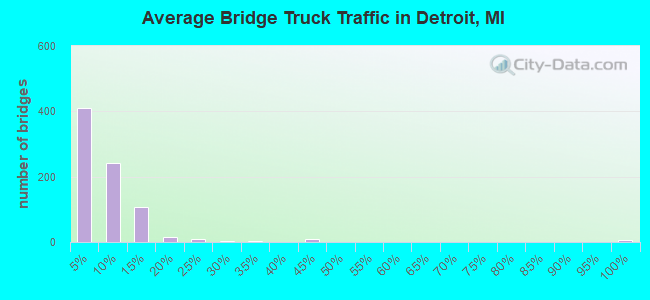
- 55,047,582Total average daily traffic
- 3,107,918Total average daily truck traffic
- National Bridge Inventory (NBI) Registered Bridges for Detroit
- No street view available for this location
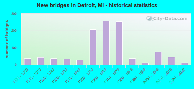
- New bridges - historical statistics
- 1Before 1900
- 371900-1909
- 431910-1919
- 371920-1929
- 331930-1939
- 291940-1949
- 2071950-1959
- 2591960-1969
- 2551970-1979
- 361980-1989
- 131990-1999
- 762000-2009
- 462010-2019
- 132020-2022
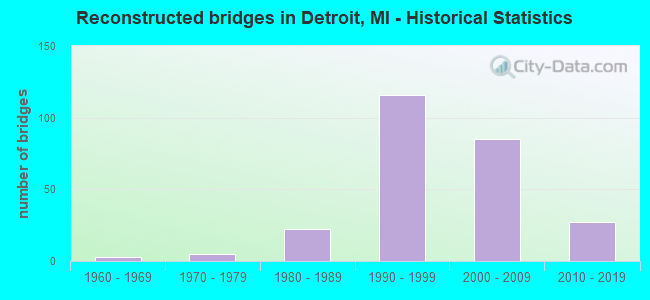
- Reconstructed bridges - Historical Statistics
- 31960-1969
- 51970-1979
- 221980-1989
- 1161990-1999
- 852000-2009
- 272010-2019
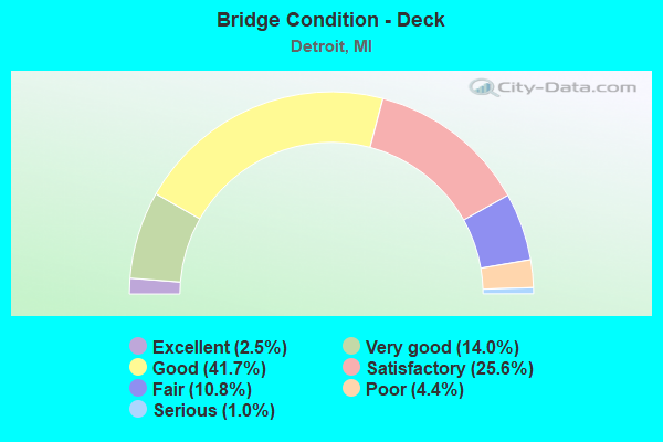
- Bridge Condition - Deck
- 2.5%Excellent
- 14.0%Very good
- 41.7%Good
- 25.6%Satisfactory
- 10.8%Fair
- 4.4%Poor
- 1.0%Serious
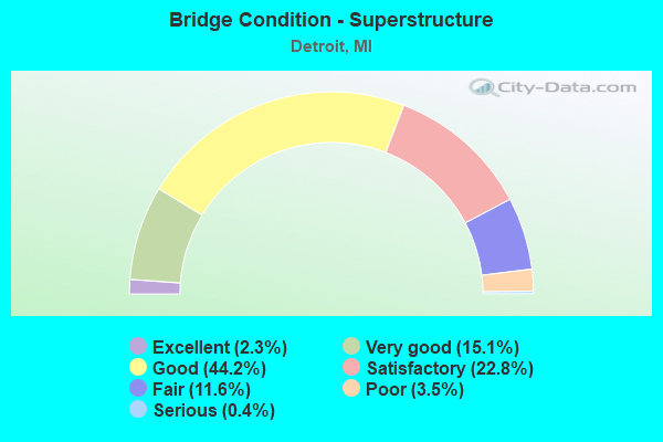
- Bridge Condition - Superstructure
- 2.3%Excellent
- 15.1%Very good
- 44.2%Good
- 22.8%Satisfactory
- 11.6%Fair
- 3.5%Poor
- 0.4%Serious
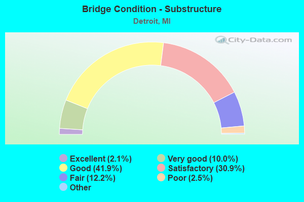
- Bridge Condition - Substructure
- 2.1%Excellent
- 10.0%Very good
- 41.9%Good
- 30.9%Satisfactory
- 12.2%Fair
- 2.5%Poor
- 0.4%Serious
- 0.2%Failed
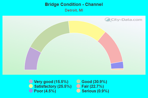
- Bridge Condition - Channel
- 15.5%Very good
- 30.9%Good
- 25.5%Satisfactory
- 22.7%Fair
- 4.5%Poor
- 0.9%Serious
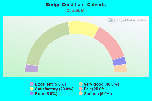
- Bridge Condition - Culverts
- 5.0%Excellent
- 40.0%Very good
- 20.0%Satisfactory
- 25.0%Fair
- 5.0%Poor
- 5.0%Serious
Find on map >> Show street view
Structure Number: 12338, Location: N OF TOLEDO (Lat: 42.318897, Lng: -83.111447), Route carried "under" structure: City street 2000, Year Built: 1928, Structure Length: 0. m, Average Daily Traffic: 12,087 (year 1996), Features Intersected: LIVERNOIS AVE, Facility Carried by Structure: CONRAIL
Minimum Vertical Clearance: 4.49m (14.73ft), Kilometerpoint: 2.334, Lanes under structure: 8, Material/Design: Steel, Design/Construction: Girder and Floorbeam System, Length of Maximum Span: 17.3m (56.8ft)
Find on map >> Show street view
Structure Number: 12339, Location: N OF TOLEDO (Lat: 42.318478, Lng: -83.111142), Route carried "under" structure: City street 2000, Year Built: 1928, Structure Length: 0. m, Average Daily Traffic: 9,042 (year 1973), Features Intersected: LIVERNOIS AVE, Facility Carried by Structure: NORFOLK SOUTHRN RR
Minimum Vertical Clearance: 4.49m (14.73ft), Kilometerpoint: 2.282, Lanes under structure: 8, Material/Design: Steel, Design/Construction: Girder and Floorbeam System, Length of Maximum Span: 17.0m (55.8ft)
Find on map >> Show street view
Structure Number: 1234, Location: S OF JOHN KRONK (Lat: 42.324014, Lng: -83.115175), Route carried "under" structure: City street 2000, Year Built: 1936, Structure Length: 0. m, Average Daily Traffic: 29,757 (year 1975), Features Intersected: LIVERNOIS AVE, Facility Carried by Structure: CONRAIL
Minimum Vertical Clearance: 4.47m (14.67ft), Kilometerpoint: 2.981, Lanes under structure: 6, Material/Design: Steel, Design/Construction: Stringer/Multi-beam, Length of Maximum Span: 14.3m (46.9ft)
Find on map >> Show street view
Structure Number: 12341, Location: W OF GRAND RIVER (Lat: 42.348267, Lng: -83.090703), Route carried "under" structure: City street 2000, Year Built: 1905, Structure Length: 0. m, Average Daily Traffic: 14,377 (year 1975), Features Intersected: WARREN AVE, Facility Carried by Structure: GRAND TRUNK W RR
Minimum Vertical Clearance: 4.11m (13.48ft), Kilometerpoint: 8.778, Lanes under structure: 4, Material/Design: Steel, Design/Construction: Girder and Floorbeam System, Length of Maximum Span: 14.3m (46.9ft)
Find on map >> Show street view
Structure Number: 12342, Location: W OF GRAND RIVER (Lat: 42.348122, Lng: -83.091167), Route carried "under" structure: City street 2000, Year Built: 1905, Structure Length: 0. m, Average Daily Traffic: 14,377 (year 1975), Features Intersected: WARREN AVE, Facility Carried by Structure: CONRAIL
Minimum Vertical Clearance: 4.14m (13.58ft), Kilometerpoint: 8.736, Lanes under structure: 4, Material/Design: Steel, Design/Construction: Girder and Floorbeam System, Length of Maximum Span: 14.3m (46.9ft)
Find on map >> Show street view
Structure Number: 12345, Location: MT ELLIOTT - MOUND RD (Lat: 42.404322, Lng: -83.038067), Route carried "under" structure: City street 2000, Year Built: 1969, Structure Length: 0. m, Average Daily Traffic: 5,795 (year 1980), Truck Traffic: 5%, Features Intersected: GTW RR AND CANIFF, Facility Carried by Structure: MT ELLIOTT - MOUND
Minimum Vertical Clearance: 4.24m (13.91ft), Kilometerpoint: 3.414, Lanes on structure: 4, Lanes under structure: 4, Material/Design: Steel, Design/Construction: Stringer/Multi-beam, Length of Maximum Span: 37.8m (124.0ft)
Find on map >> Show street view
Structure Number: 12346, Location: E OF JOHN R (Lat: 42.432314, Lng: -83.100925), Route carried "under" structure: City street 2000, Year Built: 1938, Structure Length: 0. m, Average Daily Traffic: 19,500 (year 1975), Features Intersected: SEVEN MILE RD, Facility Carried by Structure: GRAND TRUNK W RR
Minimum Vertical Clearance: 4.34m (14.24ft), Kilometerpoint: 27.336, Lanes under structure: 5, Material/Design: Steel, Design/Construction: Girder and Floorbeam System, Length of Maximum Span: 22.8m (74.8ft)
Find on map >> Show street view
Structure Number: 12348, Location: FORT ST WEST OF DEARBORN (Lat: 42.292917, Lng: -83.138386), Route carried "under" structure: State highway 85, Year Built: 1929, Structure Length: 0. m, Average Daily Traffic: 10,722 (year 2007), Truck Traffic: 14%, Features Intersected: M-85 (FORT ST), Facility Carried by Structure: CONRAIL & C&O RRS
Minimum Vertical Clearance: 4.44m (14.57ft), Kilometerpoint: 0.488, Lanes under structure: 6, Material/Design: Steel, Design/Construction: Girder and Floorbeam System, Length of Maximum Span: 23.4m (76.8ft)
Find on map >> Show street view
Structure Number: 12349, Location: FORT ST WEST OF LAWNDALE (Lat: 42.297469, Lng: -83.126200), Route carried "under" structure: State highway 85, Year Built: 1924, Structure Length: 0. m, Average Daily Traffic: 10,722 (year 2007), Truck Traffic: 14%, Features Intersected: M-85 (FORT ST), Facility Carried by Structure: NS RR
Minimum Vertical Clearance: 4.52m (14.83ft), Kilometerpoint: 1.688, Lanes under structure: 4, Material/Design: Steel, Design/Construction: Girder and Floorbeam System, Length of Maximum Span: 16.4m (53.8ft)
Find on map >> Show street view
Structure Number: 12351, Location: N OF FISHER FREEWAY (Lat: 42.304050, Lng: -83.121647), Route carried "under" structure: City street 2000, Year Built: 1930, Structure Length: 0. m, Average Daily Traffic: 10,608 (year 1969), Features Intersected: SPRINGWELLS AVE, Facility Carried by Structure: CONRAIL
Minimum Vertical Clearance: 4.44m (14.57ft), Kilometerpoint: 1.638, Lanes under structure: 2, Material/Design: Steel continuous, Design/Construction: Stringer/Multi-beam, Length of Maximum Span: 7.6m (24.9ft)
Find on map >> Show street view
Structure Number: 12352, Location: N OF FISHER FREEWAY (Lat: 42.303908, Lng: -83.121275), Route carried "under" structure: City street 2000, Year Built: 1930, Structure Length: 0. m, Average Daily Traffic: 10,608 (year 1969), Features Intersected: SPRINGWELLS AVE, Facility Carried by Structure: NORFOLK SOUTHRN RR
Minimum Vertical Clearance: 4.44m (14.57ft), Kilometerpoint: 1.605, Lanes under structure: 2, Material/Design: Steel continuous, Design/Construction: Stringer/Multi-beam, Length of Maximum Span: 7.6m (24.9ft)
Find on map >> Show street view
Structure Number: 12353, Location: N OF FORT (Lat: 42.306253, Lng: -83.120128), Route carried "under" structure: City street 2000, Year Built: 1929, Structure Length: 0. m, Average Daily Traffic: 6,911 (year 1973), Features Intersected: CENTRAL AVE, Facility Carried by Structure: CONRAIL
Minimum Vertical Clearance: 3.91m (12.83ft), Kilometerpoint: 0.459, Lanes under structure: 2, Material/Design: Steel, Design/Construction: Stringer/Multi-beam, Length of Maximum Span: 12.5m (41.0ft)
Find on map >> Show street view
Structure Number: 12354, Location: N OF FORT (Lat: 42.305914, Lng: -83.119894), Route carried "under" structure: City street 2000, Year Built: 1929, Structure Length: 0. m, Average Daily Traffic: 6,911 (year 1973), Features Intersected: CENTRAL AVE, Facility Carried by Structure: NORFOLK SOUTHRN RR
Minimum Vertical Clearance: 3.91m (12.83ft), Kilometerpoint: 0.417, Lanes under structure: 2, Material/Design: Steel, Design/Construction: Girder and Floorbeam System, Length of Maximum Span: 13.1m (43.0ft)
Find on map >> Show street view
Structure Number: 12355, Location: S OF MICHIGAN (Lat: 42.320822, Lng: -83.130236), Route carried "under" structure: City street 2000, Year Built: 1913, Structure Length: 0. m, Average Daily Traffic: 11,365 (year 1973), Features Intersected: CENTRAL AVE, Facility Carried by Structure: CONRAIL
Minimum Vertical Clearance: 4.06m (13.32ft), Kilometerpoint: 2.303, Lanes under structure: 2, Material/Design: Steel, Design/Construction: Stringer/Multi-beam, Length of Maximum Span: 10.3m (33.8ft)
Find on map >> Show street view
Structure Number: 12356, Location: S OF MICHIGAN (Lat: 42.321411, Lng: -83.130650), Route carried "under" structure: City street 2000, Year Built: 1913, Structure Length: 0. m, Average Daily Traffic: 11,365 (year 1973), Features Intersected: CENTRAL AVE, Facility Carried by Structure: CONRAIL
Minimum Vertical Clearance: 4.06m (13.32ft), Kilometerpoint: 2.358, Lanes under structure: 4, Material/Design: Steel, Design/Construction: Stringer/Multi-beam, Length of Maximum Span: 10.3m (33.8ft)
Find on map >> Show street view
Structure Number: 12357, Location: W OF LIVERNOIS (Lat: 42.315578, Lng: -83.113156), Route carried "under" structure: City street 2000, Year Built: 1924, Structure Length: 0. m, Average Daily Traffic: 21,139 (year 1974), Features Intersected: VERNOR HWY, Facility Carried by Structure: NORFOLK SOUTHRN RR
Minimum Vertical Clearance: 4.32m (14.17ft), Kilometerpoint: 2.720, Lanes under structure: 4, Material/Design: Steel continuous, Design/Construction: Stringer/Multi-beam, Length of Maximum Span: 8.2m (26.9ft)
Find on map >> Show street view
Structure Number: 12358, Location: W OF LIVERNOIS (Lat: 42.315608, Lng: -83.113661), Route carried "under" structure: City street 2000, Year Built: 1924, Structure Length: 0. m, Average Daily Traffic: 21,139 (year 1974), Features Intersected: VERNOR HWY, Facility Carried by Structure: CONRAIL
Minimum Vertical Clearance: 4.32m (14.17ft), Kilometerpoint: 2.678, Lanes under structure: 4, Material/Design: Steel continuous, Design/Construction: Stringer/Multi-beam, Length of Maximum Span: 8.8m (28.9ft)
Find on map >> Show street view
Structure Number: 12359, Location: E OF TWENTIETH (Lat: 42.328322, Lng: -83.079067), Route carried "under" structure: City street 2000, Year Built: 1914, Structure Length: 0. m, Average Daily Traffic: 18,419 (year 1973), Features Intersected: VERNOR HIGHWAY, Facility Carried by Structure: CONRAIL
Minimum Vertical Clearance: 4.11m (13.48ft), Kilometerpoint: 5.900, Lanes under structure: 4, Material/Design: Steel, Design/Construction: Girder and Floorbeam System, Length of Maximum Span: 14.6m (47.9ft)
Find on map >> Show street view
Structure Number: 1236, Location: S OF JOHN KRONK (Lat: 42.320456, Lng: -83.137169), Route carried "under" structure: City street 2000, Year Built: 1913, Structure Length: 0. m, Average Daily Traffic: 10,836 (year 1973), Features Intersected: LONYO ROAD, Facility Carried by Structure: CONRAIL
Minimum Vertical Clearance: 4.11m (13.48ft), Kilometerpoint: 0.491, Lanes under structure: 4, Material/Design: Steel continuous, Design/Construction: Stringer/Multi-beam, Length of Maximum Span: 7.3m (24.0ft)
Find on map >> Show street view
Structure Number: 12361, Location: S OF JOHN KRONK (Lat: 42.320017, Lng: -83.136889), Route carried "under" structure: City street 2000, Year Built: 1913, Structure Length: 0. m, Average Daily Traffic: 10,836 (year 1973), Features Intersected: LONYO ROAD, Facility Carried by Structure: CONRAIL
Minimum Vertical Clearance: 4.11m (13.48ft), Kilometerpoint: 0.480, Lanes under structure: 4, Material/Design: Steel continuous, Design/Construction: Stringer/Multi-beam, Length of Maximum Span: 7.9m (25.9ft)
Find on map >> Show street view
Structure Number: 12362, Location: S OF JOHN KRONK (Lat: 42.319583, Lng: -83.136558), Route carried "under" structure: City street 2000, Year Built: 1913, Structure Length: 0. m, Average Daily Traffic: 10,836 (year 1973), Features Intersected: LONYO ROAD, Facility Carried by Structure: CONRAIL
Minimum Vertical Clearance: 4.11m (13.48ft), Kilometerpoint: 0.436, Lanes under structure: 4, Material/Design: Steel continuous, Design/Construction: Stringer/Multi-beam, Length of Maximum Span: 7.9m (25.9ft)
Find on map >> Show street view
Structure Number: 12364, Location: S OF MICHIGAN (Lat: 42.327361, Lng: -83.092497), Route carried "under" structure: City street 2000, Year Built: 1895, Structure Length: 0. m, Average Daily Traffic: 6,409 (year 1971), Features Intersected: W GRAND BOULEVARD, Facility Carried by Structure: CONRAIL
Minimum Vertical Clearance: 2.69m (8.83ft), Kilometerpoint: 1.862, Lanes under structure: 2, Material/Design: Concrete, Design/Construction: Arch - Deck, Length of Maximum Span: 15.2m (49.9ft)
Find on map >> Show street view
Structure Number: 12365, Location: N OF MYRTLE (Lat: 42.334558, Lng: -83.100558), Route carried "under" structure: City street 2000, Year Built: 1908, Structure Length: 0. m, Average Daily Traffic: 5,726 (year 1973), Features Intersected: W GRAND BOULEVARD, Facility Carried by Structure: CONRAIL
Minimum Vertical Clearance: 3.83m (12.57ft), Kilometerpoint: 0.142, Lanes under structure: 4, Material/Design: Steel, Design/Construction: Girder and Floorbeam System, Length of Maximum Span: 18.9m (62.0ft)
Find on map >> Show street view
Structure Number: 12366, Location: N OF MYRTLE (Lat: 42.334169, Lng: -83.100275), Route carried "under" structure: City street 2000, Year Built: 1908, Structure Length: 0. m, Average Daily Traffic: 5,726 (year 1973), Features Intersected: W GRAND BOULEVARD, Facility Carried by Structure: CONRAIL
Minimum Vertical Clearance: 3.83m (12.57ft), Kilometerpoint: 0.092, Lanes under structure: 4, Material/Design: Steel, Design/Construction: Girder and Floorbeam System, Length of Maximum Span: 15.2m (49.9ft)
Find on map >> Show street view
Structure Number: 12367, Location: N OF MYRTLE (Lat: 42.334400, Lng: -83.100444), Route carried "under" structure: City street 2000, Year Built: 1908, Structure Length: 0. m, Average Daily Traffic: 5,726 (year 1973), Features Intersected: W GRAND BOULEVARD, Facility Carried by Structure: GRAND TRUNK W RR
Minimum Vertical Clearance: 3.83m (12.57ft), Kilometerpoint: 0.121, Lanes under structure: 4, Material/Design: Steel, Design/Construction: Girder and Floorbeam System, Length of Maximum Span: 15.2m (49.9ft)
Find on map >> Show street view
Structure Number: 12368, Location: N OF WARREN (Lat: 42.352233, Lng: -83.088383), Route carried "under" structure: City street 2000, Year Built: 1908, Structure Length: 0. m, Average Daily Traffic: 9,175 (year 1974), Features Intersected: FOURTEENTH ST, Facility Carried by Structure: CONRAIL
Minimum Vertical Clearance: 4.01m (13.16ft), Kilometerpoint: 3.079, Lanes under structure: 3, Material/Design: Steel, Design/Construction: Girder and Floorbeam System, Length of Maximum Span: 17.0m (55.8ft)
Find on map >> Show street view
Structure Number: 12369, Location: N OF WARREN (Lat: 42.351894, Lng: -83.088194), Route carried "under" structure: City street 2000, Year Built: 1908, Structure Length: 0. m, Average Daily Traffic: 9,175 (year 1974), Features Intersected: FOURTEENTH ST, Facility Carried by Structure: GRAND TRUNK W RR
Minimum Vertical Clearance: 4.01m (13.16ft), Kilometerpoint: 3.037, Lanes under structure: 3, Material/Design: Steel, Design/Construction: Girder and Floorbeam System, Length of Maximum Span: 17.0m (55.8ft)
Find on map >> Show street view
Structure Number: 12371, Location: N OF KIRBY (Lat: 42.355800, Lng: -83.085853), Route carried "under" structure: City street 2000, Year Built: 1917, Structure Length: 0. m, Average Daily Traffic: 5,813 (year 1975), Features Intersected: TWELFTH ST, Facility Carried by Structure: CONRAIL
Minimum Vertical Clearance: 3.78m (12.40ft), Kilometerpoint: 1.326, Lanes under structure: 2, Material/Design: Steel continuous, Design/Construction: Stringer/Multi-beam, Length of Maximum Span: 8.2m (26.9ft)
Find on map >> Show street view
Structure Number: 12372, Location: N OF KIRBY (Lat: 42.355511, Lng: -83.085689), Route carried "under" structure: City street 2000, Year Built: 1917, Structure Length: 0. m, Average Daily Traffic: 5,813 (year 1975), Features Intersected: TWELFTH ST, Facility Carried by Structure: GRAND TRUNK W RR
Minimum Vertical Clearance: 3.78m (12.40ft), Kilometerpoint: 1.291, Lanes under structure: 2, Material/Design: Steel continuous, Design/Construction: Stringer/Multi-beam, Length of Maximum Span: 8.2m (26.9ft)
Find on map >> Show street view
Structure Number: 12373, Location: S OF MILWAUKEE (Lat: 42.365458, Lng: -83.077297), Route carried "under" structure: City street 2000, Year Built: 1914, Structure Length: 0. m, Average Daily Traffic: 7,004 (year 1972), Features Intersected: THIRD AVE, Facility Carried by Structure: CONRAIL
Minimum Vertical Clearance: 3.83m (12.57ft), Kilometerpoint: 3.193, Lanes under structure: 4, Material/Design: Steel continuous, Design/Construction: Stringer/Multi-beam, Length of Maximum Span: 7.0m (23.0ft)
Find on map >> Show street view
Structure Number: 12374, Location: S OF MILWAUKEE (Lat: 42.365700, Lng: -83.077450), Route carried "under" structure: City street 2000, Year Built: 1947, Structure Length: 0. m, Average Daily Traffic: 7,004 (year 1972), Features Intersected: THIRD AVE, Facility Carried by Structure: CONRAIL
Minimum Vertical Clearance: 3.83m (12.57ft), Kilometerpoint: 3.222, Lanes under structure: 4, Material/Design: Steel, Design/Construction: Stringer/Multi-beam, Length of Maximum Span: 20.7m (67.9ft)
Find on map >> Show street view
Structure Number: 12375, Location: S OF MILWAUKEE (Lat: 42.365608, Lng: -83.077392), Route carried "under" structure: City street 2000, Year Built: 1914, Structure Length: 0. m, Average Daily Traffic: 7,004 (year 1972), Features Intersected: THIRD AVE, Facility Carried by Structure: GRAND TRUNK W RR
Minimum Vertical Clearance: 3.83m (12.57ft), Kilometerpoint: 3.211, Lanes under structure: 4, Material/Design: Steel continuous, Design/Construction: Stringer/Multi-beam, Length of Maximum Span: 7.0m (23.0ft)
Find on map >> Show street view
Structure Number: 12376, Location: S OF MILWAUKEE (Lat: 42.366678, Lng: -83.075317), Route carried "under" structure: City street 2000, Year Built: 1914, Structure Length: 0. m, Average Daily Traffic: 9,021 (year 1975), Features Intersected: SECOND AVE, Facility Carried by Structure: CONRAIL
Minimum Vertical Clearance: 3.86m (12.66ft), Kilometerpoint: 0.715, Lanes under structure: 4, Material/Design: Steel continuous, Design/Construction: Stringer/Multi-beam, Length of Maximum Span: 7.6m (24.9ft)
Find on map >> Show street view
Structure Number: 12377, Location: S OF MILWAUKEE (Lat: 42.366436, Lng: -83.075144), Route carried "under" structure: City street 2000, Year Built: 1914, Structure Length: 0. m, Average Daily Traffic: 9,021 (year 1975), Features Intersected: SECOND AVE, Facility Carried by Structure: GRAND TRUNK W RR
Minimum Vertical Clearance: 3.86m (12.66ft), Kilometerpoint: 0.684, Lanes under structure: 4, Material/Design: Steel continuous, Design/Construction: Stringer/Multi-beam, Length of Maximum Span: 7.6m (24.9ft)
Find on map >> Show street view
Structure Number: 12378, Location: S OF MILWAUKEE (Lat: 42.367447, Lng: -83.073286), Route carried "under" structure: City street 2000, Year Built: 1914, Structure Length: 0. m, Average Daily Traffic: 12,020 (year 1972), Features Intersected: CASS AVE, Facility Carried by Structure: CONRAIL
Minimum Vertical Clearance: 3.83m (12.57ft), Kilometerpoint: 4.748, Lanes under structure: 4, Material/Design: Steel continuous, Design/Construction: Stringer/Multi-beam, Length of Maximum Span: 7.6m (24.9ft)
Find on map >> Show street view
Structure Number: 12379, Location: S OF MILWAUKEE (Lat: 42.367203, Lng: -83.073089), Route carried "under" structure: City street 2000, Year Built: 1914, Structure Length: 0. m, Average Daily Traffic: 12,020 (year 1972), Features Intersected: CASS AVE, Facility Carried by Structure: GRAND TRUNK W RR
Minimum Vertical Clearance: 3.83m (12.57ft), Kilometerpoint: 4.716, Lanes under structure: 4, Material/Design: Steel continuous, Design/Construction: Stringer/Multi-beam, Length of Maximum Span: 7.6m (24.9ft)
Find on map >> Show street view
Structure Number: 12382, Location: S OF BALTIMORE (Lat: 42.368817, Lng: -83.069592), Route carried "under" structure: City street 2000, Year Built: 1911, Structure Length: 0. m, Average Daily Traffic: 14,776 (year 1973), Features Intersected: JOHN R ST, Facility Carried by Structure: CONRAIL
Minimum Vertical Clearance: 3.86m (12.66ft), Kilometerpoint: 3.597, Lanes under structure: 2, Material/Design: Steel, Design/Construction: Stringer/Multi-beam, Length of Maximum Span: 9.1m (29.9ft)
Find on map >> Show street view
Structure Number: 12383, Location: S OF BALTIMORE (Lat: 42.368586, Lng: -83.069436), Route carried "under" structure: City street 2000, Year Built: 1911, Structure Length: 0. m, Average Daily Traffic: 14,776 (year 1973), Features Intersected: JOHN R ST, Facility Carried by Structure: CONRAIL
Minimum Vertical Clearance: 3.86m (12.66ft), Kilometerpoint: 3.568, Lanes under structure: 2, Material/Design: Steel, Design/Construction: Girder and Floorbeam System, Length of Maximum Span: 8.8m (28.9ft)
Find on map >> Show street view
Structure Number: 12384, Location: S OF BALTIMORE (Lat: 42.368661, Lng: -83.069489), Route carried "under" structure: City street 2000, Year Built: 1911, Structure Length: 0. m, Average Daily Traffic: 14,776 (year 1973), Features Intersected: JOHN R ST, Facility Carried by Structure: GRAND TRUNK W RR
Minimum Vertical Clearance: 3.86m (12.66ft), Kilometerpoint: 3.578, Lanes under structure: 2, Material/Design: Steel, Design/Construction: Girder and Floorbeam System, Length of Maximum Span: 8.8m (28.9ft)
Find on map >> Show street view
Structure Number: 12385, Location: N OF SEVEN MILE (Lat: 42.433961, Lng: -83.102431), Route carried "under" structure: City street 2000, Year Built: 1938, Structure Length: 0. m, Average Daily Traffic: 12,786 (year 1972), Features Intersected: JOHN R ST, Facility Carried by Structure: GRAND TRUNK W RR
Minimum Vertical Clearance: 4.29m (14.07ft), Kilometerpoint: 2.242, Lanes under structure: 4, Material/Design: Steel, Design/Construction: Girder and Floorbeam System, Length of Maximum Span: 27.4m (89.9ft)
Find on map >> Show street view
Structure Number: 12386, Location: S OF MILWAUKEE (Lat: 42.369631, Lng: -83.067117), Route carried "under" structure: City street 2000, Year Built: 1911, Structure Length: 0. m, Average Daily Traffic: 6,632 (year 1975), Features Intersected: BRUSH ST, Facility Carried by Structure: CONRAIL
Minimum Vertical Clearance: 3.53m (11.58ft), Kilometerpoint: 1.865, Lanes under structure: 2, Material/Design: Steel, Design/Construction: Girder and Floorbeam System, Length of Maximum Span: 9.1m (29.9ft)
Find on map >> Show street view
Structure Number: 12387, Location: S OF MILWAUKEE (Lat: 42.369392, Lng: -83.066953), Route carried "under" structure: City street 2000, Year Built: 1911, Structure Length: 0. m, Average Daily Traffic: 6,632 (year 1975), Features Intersected: BRUSH ST, Facility Carried by Structure: CONRAIL
Minimum Vertical Clearance: 3.53m (11.58ft), Kilometerpoint: 1.835, Lanes under structure: 2, Material/Design: Steel, Design/Construction: Girder and Floorbeam System, Length of Maximum Span: 8.8m (28.9ft)
Find on map >> Show street view
Structure Number: 12388, Location: S OF MILWAUKEE (Lat: 42.369761, Lng: -83.067208), Route carried "under" structure: City street 2000, Year Built: 1911, Structure Length: 0. m, Average Daily Traffic: 6,632 (year 1975), Features Intersected: BRUSH ST, Facility Carried by Structure: GTWRR & CONR
Minimum Vertical Clearance: 3.53m (11.58ft), Kilometerpoint: 1.881, Lanes under structure: 2, Material/Design: Steel, Design/Construction: Stringer/Multi-beam, Length of Maximum Span: 9.1m (29.9ft)
Find on map >> Show street view
Structure Number: 12389, Location: S OF TROMBLY (Lat: 42.371853, Lng: -83.057425), Route carried "under" structure: City street 2000, Year Built: 1929, Structure Length: 0. m, Average Daily Traffic: 16,257 (year 1972), Features Intersected: RUSSELL ST, Facility Carried by Structure: CONRAIL
Minimum Vertical Clearance: 4.42m (14.50ft), Kilometerpoint: 1.735, Lanes under structure: 4, Material/Design: Steel, Design/Construction: Girder and Floorbeam System, Length of Maximum Span: 16.1m (52.8ft)
Find on map >> Show street view
Structure Number: 1239, Location: S OF TROMBLY (Lat: 42.371567, Lng: -83.057233), Route carried "under" structure: City street 2000, Year Built: 1928, Structure Length: 0. m, Average Daily Traffic: 16,257 (year 1972), Features Intersected: RUSSELL ST, Facility Carried by Structure: GRAND TRUNK W RR
Minimum Vertical Clearance: 4.42m (14.50ft), Kilometerpoint: 1.700, Lanes under structure: 4, Material/Design: Steel, Design/Construction: Girder and Floorbeam System, Length of Maximum Span: 16.1m (52.8ft)
Find on map >> Show street view
Structure Number: 12391, Location: W OF ST AUBIN (Lat: 42.376936, Lng: -83.055217), Route carried "under" structure: ServiceCity street , Year Built: 1973, Structure Length: 0. m, Average Daily Traffic: 400 (year 0000), Features Intersected: GTW RR & RIVARD ST, Facility Carried by Structure: E GRAND BOULEVARD
Minimum Vertical Clearance: 6.86m (22.51ft), Kilometerpoint: 0.340, Lanes on structure: 6, Lanes under structure: 7, Material/Design: Steel continuous, Design/Construction: Stringer/Multi-beam, Length of Maximum Span: 29.9m (98.1ft)
Find on map >> Show street view
Structure Number: 12394, Location: W OF JEFFRIES FREEWAY (Lat: 42.341542, Lng: -83.095725), Route carried "under" structure: Alternate City street 2000, Year Built: 1900, Structure Length: 0. m, Average Daily Traffic: 4,549 (year 1973), Features Intersected: BUCHANAN ST, Facility Carried by Structure: GRAND TRUNK W RR
Minimum Vertical Clearance: 4.36m (14.30ft), Kilometerpoint: 0.946, Lanes under structure: 2, Material/Design: Steel, Design/Construction: Stringer/Multi-beam, Length of Maximum Span: 12.2m (40.0ft)
Find on map >> Show street view
Structure Number: 12395, Location: W OF JEFFRIES FREEWAY (Lat: 42.341689, Lng: -83.095261), Route carried "under" structure: Alternate City street 2000, Year Built: 1900, Structure Length: 0. m, Average Daily Traffic: 4,549 (year 1973), Features Intersected: BUCHANAN ST, Facility Carried by Structure: CONRAIL
Minimum Vertical Clearance: 4.44m (14.57ft), Kilometerpoint: 0.988, Lanes under structure: 2, Material/Design: Steel, Design/Construction: Girder and Floorbeam System, Length of Maximum Span: 12.5m (41.0ft)
Find on map >> Show street view
Structure Number: 12396, Location: E OF FOURTEENTH (Lat: 42.354600, Lng: -83.084775), Route carried "under" structure: Alternate City street 2000, Year Built: 1917, Structure Length: 0. m, Average Daily Traffic: 3,485 (year 1975), Features Intersected: EDSEL FORD SERVICE DR, Facility Carried by Structure: GRAND TRUNK W RR
Minimum Vertical Clearance: 3.91m (12.83ft), Kilometerpoint: 43.381, Lanes under structure: 2, Material/Design: Steel, Design/Construction: Girder and Floorbeam System, Length of Maximum Span: 22.2m (72.8ft)
Find on map >> Show street view
Structure Number: 12397, Location: E OF FOURTEENTH (Lat: 42.354686, Lng: -83.084494), Route carried "under" structure: Alternate City street 2000, Year Built: 1917, Structure Length: 0. m, Average Daily Traffic: 3,485 (year 1975), Features Intersected: EDSEL FORD SERVICE DR, Facility Carried by Structure: CONRAIL
Minimum Vertical Clearance: 3.91m (12.83ft), Kilometerpoint: 43.406, Lanes under structure: 2, Material/Design: Steel, Design/Construction: Girder and Floorbeam System, Length of Maximum Span: 15.8m (51.8ft)
Find on map >> Show street view
Structure Number: 12398, Location: W OF CHRYSLER FREEWAY (Lat: 42.372758, Lng: -83.062614), Route carried "under" structure: Alternate City street 2000, Year Built: 1912, Structure Length: 0. m, Average Daily Traffic: 9,613 (year 1973), Features Intersected: MILWAUKEE AVE, Facility Carried by Structure: CONRAIL
Minimum Vertical Clearance: 4.19m (13.75ft), Kilometerpoint: 1.869, Lanes under structure: 2, Material/Design: Steel, Design/Construction: Girder and Floorbeam System, Length of Maximum Span: 20.7m (67.9ft)
Find on map >> Show street view
Structure Number: 12399, Location: W OF CHRYSLER FREEWAY (Lat: 42.372986, Lng: -83.062028), Route carried "under" structure: Alternate City street 2000, Year Built: 1912, Structure Length: 0. m, Average Daily Traffic: 9,613 (year 1973), Features Intersected: MILWAUKEE AVE, Facility Carried by Structure: GRAND TRUNK W RR
Minimum Vertical Clearance: 4.19m (13.75ft), Kilometerpoint: 1.922, Lanes under structure: 2, Material/Design: Steel continuous, Design/Construction: Stringer/Multi-beam, Length of Maximum Span: 17.0m (55.8ft)
Find on map >> Show street view
Structure Number: 124, Location: W OF JOHN R (Lat: 42.439481, Lng: -83.106764), Route carried "under" structure: Alternate City street 2000, Year Built: 1940, Structure Length: 0. m, Average Daily Traffic: 7,131 (year 1975), Features Intersected: STATE FAIR AVE, Facility Carried by Structure: GRAND TRUNK W RR
Minimum Vertical Clearance: 4.16m (13.65ft), Kilometerpoint: 1.099, Lanes under structure: 4, Material/Design: Steel continuous, Design/Construction: Girder and Floorbeam System, Length of Maximum Span: 15.8m (51.8ft)
Find on map >> Show street view
Structure Number: 12401, Location: N OF FORT (Lat: 42.309339, Lng: -83.118000), Route carried "under" structure: City street , Year Built: 1929, Structure Length: 0. m, Average Daily Traffic: 3,149 (year 1978), Features Intersected: GREEN, Facility Carried by Structure: CONRAIL
Minimum Vertical Clearance: 3.91m (12.83ft), Kilometerpoint: 1.817, Lanes under structure: 2, Material/Design: Steel, Design/Construction: Stringer/Multi-beam, Length of Maximum Span: 7.9m (25.9ft)
Find on map >> Show street view
Structure Number: 12402, Location: N OF FORT (Lat: 42.308997, Lng: -83.117764), Route carried "under" structure: City street , Year Built: 1929, Structure Length: 0. m, Average Daily Traffic: 3,149 (year 1978), Features Intersected: GREEN, Facility Carried by Structure: NORFOLK SOUTHRN RR
Minimum Vertical Clearance: 3.91m (12.83ft), Kilometerpoint: 1.775, Lanes under structure: 2, Material/Design: Steel, Design/Construction: Stringer/Multi-beam, Length of Maximum Span: 8.2m (26.9ft)
Find on map >> Show street view
Structure Number: 12403, Location: S OF VERNOR HWY (Lat: 42.313672, Lng: -83.115003), Route carried "under" structure: City street , Year Built: 1928, Structure Length: 0. m, Average Daily Traffic: 4,340 (year 1978), Features Intersected: WATERMAN, Facility Carried by Structure: CONRAIL
Minimum Vertical Clearance: 3.86m (12.66ft), Kilometerpoint: 2.105, Lanes under structure: 2, Material/Design: Steel, Design/Construction: Stringer/Multi-beam, Length of Maximum Span: 12.5m (41.0ft)
Find on map >> Show street view
Structure Number: 12404, Location: S OF VERNOR HWY (Lat: 42.313297, Lng: -83.114731), Route carried "under" structure: City street , Year Built: 1926, Structure Length: 0. m, Average Daily Traffic: 4,340 (year 1978), Features Intersected: WATERMAN, Facility Carried by Structure: NORFOLK SOUTHRN RR
Minimum Vertical Clearance: 3.86m (12.66ft), Kilometerpoint: 2.058, Lanes under structure: 2, Material/Design: Steel, Design/Construction: Girder and Floorbeam System, Length of Maximum Span: 12.5m (41.0ft)
Find on map >> Show street view
Structure Number: 12405, Location: S OF KONKEL (Lat: 42.325186, Lng: -83.107131), Route carried "under" structure: Alternate City street 2000, Year Built: 1907, Structure Length: 0. m, Average Daily Traffic: 5,627 (year 1972), Features Intersected: JUNCTION AVE, Facility Carried by Structure: CONRAIL
Minimum Vertical Clearance: 4.09m (13.42ft), Kilometerpoint: 2.699, Lanes under structure: 4, Material/Design: Steel, Design/Construction: Girder and Floorbeam System, Length of Maximum Span: 16.1m (52.8ft)
Find on map >> Show street view
Structure Number: 12406, Location: S OF KONKEL (Lat: 42.325039, Lng: -83.107022), Route carried "under" structure: Alternate City street 2000, Year Built: 1907, Structure Length: 0. m, Average Daily Traffic: 5,627 (year 1972), Features Intersected: JUNCTION AVE, Facility Carried by Structure: CONRAIL
Minimum Vertical Clearance: 4.09m (13.42ft), Kilometerpoint: 2.681, Lanes under structure: 4, Material/Design: Steel, Design/Construction: Girder and Floorbeam System, Length of Maximum Span: 18.6m (61.0ft)
Find on map >> Show street view
Structure Number: 12407, Location: S OF KONKEL (Lat: 42.324925, Lng: -83.106942), Route carried "under" structure: Alternate City street 2000, Year Built: 1907, Structure Length: 0. m, Average Daily Traffic: 5,627 (year 1972), Features Intersected: JUNCTION AVE, Facility Carried by Structure: NORFOLK SOUTHRN RR
Minimum Vertical Clearance: 4.09m (13.42ft), Kilometerpoint: 2.667, Lanes under structure: 4, Material/Design: Steel, Design/Construction: Girder and Floorbeam System, Length of Maximum Span: 18.6m (61.0ft)
Find on map >> Show street view
Structure Number: 12408, Location: S OF KONKEL (Lat: 42.325525, Lng: -83.107383), Route carried "under" structure: Alternate City street 2000, Year Built: 1907, Structure Length: 0. m, Average Daily Traffic: 5,627 (year 1972), Features Intersected: JUNCTION AVE, Facility Carried by Structure: CONRAIL
Minimum Vertical Clearance: 4.09m (13.42ft), Kilometerpoint: 2.742, Lanes under structure: 4, Material/Design: Steel, Design/Construction: Girder and Floorbeam System, Length of Maximum Span: 16.1m (52.8ft)
Find on map >> Show street view
Structure Number: 12409, Location: S. OF KONKEL (Lat: 42.324614, Lng: -83.106719), Route carried "under" structure: Alternate City street 2000, Year Built: 1907, Structure Length: 0. m, Average Daily Traffic: 5,627 (year 1972), Features Intersected: JUNCTION AVE, Facility Carried by Structure: GRAND TRUNK W RR
Minimum Vertical Clearance: 4.09m (13.42ft), Kilometerpoint: 2.627, Lanes under structure: 4, Material/Design: Steel, Design/Construction: Girder and Floorbeam System, Length of Maximum Span: 15.5m (50.9ft)
Find on map >> Show street view
Structure Number: 1241, Location: S OF MICHIGAN (Lat: 42.326278, Lng: -83.100131), Route carried "under" structure: Alternate City street 2000, Year Built: 1908, Structure Length: 0. m, Average Daily Traffic: 7,637 (year 1974), Features Intersected: CLARK AVE, Facility Carried by Structure: CONRAIL
Minimum Vertical Clearance: 3.83m (12.57ft), Kilometerpoint: 0.624, Lanes under structure: 3, Material/Design: Steel, Design/Construction: Stringer/Multi-beam, Length of Maximum Span: 10.0m (32.8ft)
Find on map >> Show street view
Structure Number: 12411, Location: S OF MICHIGAN (Lat: 42.326578, Lng: -83.097972), Route carried "under" structure: Alternate City street 2000, Year Built: 1908, Structure Length: 0. m, Average Daily Traffic: 7,373 (year 1973), Features Intersected: SCOTTEN AVE, Facility Carried by Structure: CONRAIL
Minimum Vertical Clearance: 4.21m (13.81ft), Kilometerpoint: 1.508, Lanes under structure: 3, Material/Design: Steel, Design/Construction: Stringer/Multi-beam, Length of Maximum Span: 9.7m (31.8ft)
Find on map >> Show street view
Structure Number: 12412, Location: N OF MICHIGAN (Lat: 42.332261, Lng: -83.102000), Route carried "under" structure: City street , Year Built: 1909, Structure Length: 0. m, Average Daily Traffic: 7,516 (year 1977), Features Intersected: SCOTTEN, Facility Carried by Structure: CONRAIL
Minimum Vertical Clearance: 3.83m (12.57ft), Kilometerpoint: 2.211, Lanes under structure: 2, Material/Design: Steel, Design/Construction: Girder and Floorbeam System, Length of Maximum Span: 11.2m (36.7ft)
Find on map >> Show street view
Structure Number: 12413, Location: N OF MICHIGAN (Lat: 42.332347, Lng: -83.102075), Route carried "under" structure: City street , Year Built: 1909, Structure Length: 0. m, Average Daily Traffic: 7,516 (year 1977), Features Intersected: SCOTTEN, Facility Carried by Structure: CONRAIL
Minimum Vertical Clearance: 3.83m (12.57ft), Kilometerpoint: 2.223, Lanes under structure: 2, Material/Design: Steel, Design/Construction: Girder and Floorbeam System, Length of Maximum Span: 11.2m (36.7ft)
Find on map >> Show street view
Structure Number: 12414, Location: N OF MICHIGAN (Lat: 42.332425, Lng: -83.102131), Route carried "under" structure: City street , Year Built: 1909, Structure Length: 0. m, Average Daily Traffic: 7,516 (year 1977), Features Intersected: SCOTTEN, Facility Carried by Structure: GTWRR
Minimum Vertical Clearance: 3.83m (12.57ft), Kilometerpoint: 2.232, Lanes under structure: 2, Material/Design: Steel, Design/Construction: Girder and Floorbeam System, Length of Maximum Span: 14.0m (45.9ft)
Find on map >> Show street view
Structure Number: 12415, Location: S OF MICHIGAN (Lat: 42.327706, Lng: -83.089392), Route carried "under" structure: City street , Year Built: 1909, Structure Length: 0. m, Average Daily Traffic: 994 (year 1978), Features Intersected: TWENTY-FOURTH, Facility Carried by Structure: CONRAIL
Minimum Vertical Clearance: 3.86m (12.66ft), Kilometerpoint: 1.086, Lanes under structure: 2, Material/Design: Steel, Design/Construction: Stringer/Multi-beam, Length of Maximum Span: 9.7m (31.8ft)
Find on map >> Show street view
Structure Number: 12416, Location: S OF BUCHANAN (Lat: 42.339431, Lng: -83.097186), Route carried "under" structure: City street , Year Built: 1931, Structure Length: 0. m, Average Daily Traffic: 2,491 (year 1978), Features Intersected: TWENTY-FOURTH, Facility Carried by Structure: CONRAIL
Minimum Vertical Clearance: 4.19m (13.75ft), Kilometerpoint: 2.532, Lanes under structure: 2, Material/Design: Steel, Design/Construction: Stringer/Multi-beam, Length of Maximum Span: 10.3m (33.8ft)
Find on map >> Show street view
Structure Number: 12417, Location: S OF BUCHANAN (Lat: 42.339158, Lng: -83.097011), Route carried "under" structure: City street , Year Built: 1931, Structure Length: 0. m, Average Daily Traffic: 2,491 (year 1978), Features Intersected: TWENTY-FOURTH, Facility Carried by Structure: GTWRR
Minimum Vertical Clearance: 4.19m (13.75ft), Kilometerpoint: 2.498, Lanes under structure: 2, Material/Design: Steel, Design/Construction: Stringer/Multi-beam, Length of Maximum Span: 10.3m (33.8ft)
Find on map >> Show street view
Structure Number: 12418, Location: S OF MICHIGAN (Lat: 42.328217, Lng: -83.082489), Route carried "under" structure: Alternate City street 2000, Year Built: 1910, Structure Length: 0. m, Average Daily Traffic: 990 (year 1975), Features Intersected: TWENTIETH, Facility Carried by Structure: CONRAIL
Minimum Vertical Clearance: 3.58m (11.75ft), Kilometerpoint: 0.045, Lanes under structure: 2, Material/Design: Steel, Design/Construction: Stringer/Multi-beam, Length of Maximum Span: 10.0m (32.8ft)
Find on map >> Show street view
Structure Number: 12419, Location: N OF STANLEY (Lat: 42.359750, Lng: -83.083122), Route carried "under" structure: Alternate City street 2000, Year Built: 1916, Structure Length: 0. m, Average Daily Traffic: 8,024 (year 1975), Features Intersected: TRUMBULL AVE, Facility Carried by Structure: CONRAIL
Minimum Vertical Clearance: 4.06m (13.32ft), Kilometerpoint: 4.294, Lanes under structure: 4, Material/Design: Steel continuous, Design/Construction: Stringer/Multi-beam, Length of Maximum Span: 11.2m (36.7ft)
Find on map >> Show street view
Structure Number: 1242, Location: N OF STANLEY (Lat: 42.359461, Lng: -83.082953), Route carried "under" structure: Alternate City street 2000, Year Built: 1916, Structure Length: 0. m, Average Daily Traffic: 8,024 (year 1975), Features Intersected: TRUMBULL AVE, Facility Carried by Structure: GRAND TRUNK W RR
Minimum Vertical Clearance: 4.06m (13.32ft), Kilometerpoint: 4.258, Lanes under structure: 4, Material/Design: Steel continuous, Design/Construction: Stringer/Multi-beam, Length of Maximum Span: 11.2m (36.7ft)
Find on map >> Show street view
Structure Number: 12421, Location: S OF MILWAUKEE (Lat: 42.370078, Lng: -83.065911), Route carried "under" structure: Alternate City street 2000, Year Built: 1911, Structure Length: 0. m, Average Daily Traffic: 4,040 (year 1974), Features Intersected: BEAUBIEN ST, Facility Carried by Structure: CONRAIL
Minimum Vertical Clearance: 4.16m (13.65ft), Kilometerpoint: 1.073, Lanes under structure: 4, Material/Design: Steel, Design/Construction: Girder and Floorbeam System, Length of Maximum Span: 13.4m (44.0ft)
Find on map >> Show street view
Structure Number: 12422, Location: S OF MILWAUKEE (Lat: 42.369839, Lng: -83.065750), Route carried "under" structure: Alternate City street 2000, Year Built: 1911, Structure Length: 0. m, Average Daily Traffic: 4,040 (year 1974), Features Intersected: BEAUBIEN ST, Facility Carried by Structure: CONRAIL
Minimum Vertical Clearance: 4.16m (13.65ft), Kilometerpoint: 1.045, Lanes under structure: 4, Material/Design: Steel, Design/Construction: Girder and Floorbeam System, Length of Maximum Span: 13.1m (43.0ft)
Find on map >> Show street view
Structure Number: 12423, Location: S OF MILWAUKEE (Lat: 42.370369, Lng: -83.066103), Route carried "under" structure: Alternate City street 2000, Year Built: 1911, Structure Length: 0. m, Average Daily Traffic: 4,040 (year 1974), Features Intersected: BEAUBIEN ST, Facility Carried by Structure: GTW & CONRAIL RR
Minimum Vertical Clearance: 4.16m (13.65ft), Kilometerpoint: 1.119, Lanes under structure: 4, Material/Design: Steel, Design/Construction: Stringer/Multi-beam, Length of Maximum Span: 13.4m (44.0ft)
Find on map >> Show street view
Structure Number: 12424, Location: N OF E GRAND BOULEVARD (Lat: 42.375369, Lng: -83.060050), Route carried "under" structure: City street 2000, Year Built: 1912, Structure Length: 0. m, Average Daily Traffic: 6,030 (year 1969), Features Intersected: RUSSELL ST, Facility Carried by Structure: GRAND TRUNK W RR
Minimum Vertical Clearance: 4.26m (13.98ft), Kilometerpoint: 0.064, Lanes under structure: 3, Material/Design: Steel, Design/Construction: Girder and Floorbeam System, Length of Maximum Span: 13.1m (43.0ft)
Find on map >> Show street view
Structure Number: 12425, Location: N OF E GRAND BOULEVARD (Lat: 42.375308, Lng: -83.059831), Route carried "under" structure: City street 2000, Year Built: 1912, Structure Length: 0. m, Average Daily Traffic: 6,030 (year 1969), Features Intersected: RUSSELL ST, Facility Carried by Structure: CONRAIL
Minimum Vertical Clearance: 4.26m (13.98ft), Kilometerpoint: 2.169, Lanes under structure: 3, Material/Design: Steel, Design/Construction: Girder and Floorbeam System, Length of Maximum Span: 13.1m (43.0ft)
Find on map >> Show street view
Structure Number: 12429, Location: N OF FORT (Lat: 42.298750, Lng: -83.125308), Route carried "under" structure: City street , Year Built: 1930, Structure Length: 0. m, Average Daily Traffic: 2,287 (year 1978), Features Intersected: LAWNDALE, Facility Carried by Structure: CONRAIL
Minimum Vertical Clearance: 4.01m (13.16ft), Kilometerpoint: 0.090, Lanes under structure: 2, Material/Design: Steel, Design/Construction: Stringer/Multi-beam, Length of Maximum Span: 8.2m (26.9ft)
Find on map >> Show street view
Structure Number: 1243, Location: N OF FORT (Lat: 42.298400, Lng: -83.125081), Route carried "under" structure: City street , Year Built: 1930, Structure Length: 0. m, Average Daily Traffic: 2,287 (year 1978), Features Intersected: LAWNDALE, Facility Carried by Structure: NORFOLK SOUTHRN RR
Minimum Vertical Clearance: 4.01m (13.16ft), Kilometerpoint: 0.048, Lanes under structure: 2, Material/Design: Steel, Design/Construction: Girder and Floorbeam System, Length of Maximum Span: 8.2m (26.9ft)
Find on map >> Show street view
Structure Number: 12431, Location: S OF MICHIGAN (Lat: 42.327164, Lng: -83.093903), Route carried "under" structure: City street , Year Built: 1909, Structure Length: 0. m, Average Daily Traffic: 2,118 (year 1978), Features Intersected: VINEWOOD, Facility Carried by Structure: CONRAIL
Minimum Vertical Clearance: 3.81m (12.50ft), Kilometerpoint: 1.357, Lanes under structure: 2, Material/Design: Steel, Design/Construction: Stringer/Multi-beam, Length of Maximum Span: 9.7m (31.8ft)
Find on map >> Show street view
Structure Number: 12432, Location: E OF GRAND BLVD (Lat: 42.335261, Lng: -83.099658), Route carried "under" structure: City street , Year Built: 1908, Structure Length: 0. m, Average Daily Traffic: 1,238 (year 1978), Features Intersected: VINEWOOD, Facility Carried by Structure: CONRAIL
Minimum Vertical Clearance: 3.88m (12.73ft), Kilometerpoint: 2.372, Lanes under structure: 2, Material/Design: Steel, Design/Construction: Girder and Floorbeam System, Length of Maximum Span: 12.2m (40.0ft)
Find on map >> Show street view
Structure Number: 12433, Location: E OF GRAND BLVD (Lat: 42.335539, Lng: -83.099867), Route carried "under" structure: City street , Year Built: 1908, Structure Length: 0. m, Average Daily Traffic: 1,238 (year 1978), Features Intersected: VINEWOOD, Facility Carried by Structure: CONRAIL
Minimum Vertical Clearance: 3.88m (12.73ft), Kilometerpoint: 2.408, Lanes under structure: 2, Material/Design: Steel, Design/Construction: Girder and Floorbeam System, Length of Maximum Span: 11.5m (37.7ft)
Find on map >> Show street view
Structure Number: 12434, Location: E OF GRAND BLVD (Lat: 42.335386, Lng: -83.099753), Route carried "under" structure: City street , Year Built: 1908, Structure Length: 0. m, Average Daily Traffic: 1,238 (year 1978), Features Intersected: VINEWOOD, Facility Carried by Structure: GTWRR
Minimum Vertical Clearance: 3.88m (12.73ft), Kilometerpoint: 2.388, Lanes under structure: 2, Material/Design: Steel, Design/Construction: Girder and Floorbeam System, Length of Maximum Span: 12.2m (40.0ft)
Find on map >> Show street view
Structure Number: 12435, Location: S OF MICHIGAN (Lat: 42.327867, Lng: -83.088022), Route carried "under" structure: City street , Year Built: 1908, Structure Length: 0. m, Average Daily Traffic: 696 (year 1978), Features Intersected: TWENTY-THIRD, Facility Carried by Structure: CONRAIL
Minimum Vertical Clearance: 3.58m (11.75ft), Kilometerpoint: 0.288, Lanes under structure: 2, Material/Design: Steel, Design/Construction: Stringer/Multi-beam, Length of Maximum Span: 10.3m (33.8ft)
Find on map >> Show street view
Structure Number: 12436, Location: S OF W GRAND BLVD (Lat: 42.363822, Lng: -83.079975), Route carried "under" structure: City street , Year Built: 1906, Structure Length: 0. m, Average Daily Traffic: 1,681 (year 1978), Features Intersected: LODGE SER DR (HAMILTON), Facility Carried by Structure: CONRAIL
Minimum Vertical Clearance: 4.09m (13.42ft), Kilometerpoint: 2.454, Lanes under structure: 4, Material/Design: Steel, Design/Construction: Girder and Floorbeam System, Length of Maximum Span: 18.2m (59.7ft)
Find on map >> Show street view
Structure Number: 12437, Location: S OF W GRAND BLVD (Lat: 42.363569, Lng: -83.079828), Route carried "under" structure: City street , Year Built: 1906, Structure Length: 0. m, Average Daily Traffic: 1,681 (year 1978), Features Intersected: LODGE SER DR (HAMILTON), Facility Carried by Structure: GTWRR
Minimum Vertical Clearance: 4.09m (13.42ft), Kilometerpoint: 2.485, Lanes under structure: 4, Material/Design: Steel, Design/Construction: Girder and Floorbeam System, Length of Maximum Span: 18.2m (59.7ft)
Find on map >> Show street view
Structure Number: 12438, Location: N OF PIQUETTE (Lat: 42.371403, Lng: -83.062103), Route carried "under" structure: City street , Year Built: 1928, Structure Length: 0. m, Average Daily Traffic: 1,231 (year 1978), Features Intersected: HASTINGS, Facility Carried by Structure: CONRAIL
Minimum Vertical Clearance: 4.11m (13.48ft), Kilometerpoint: 0.378, Lanes under structure: 2, Material/Design: Steel, Design/Construction: Girder and Floorbeam System, Length of Maximum Span: 9.4m (30.8ft)
Find on map >> Show street view
Structure Number: 12439, Location: N OF PIQUETTE (Lat: 42.371489, Lng: -83.062158), Route carried "under" structure: City street , Year Built: 1928, Structure Length: 0. m, Average Daily Traffic: 1,231 (year 1978), Features Intersected: HASTINGS, Facility Carried by Structure: NORFOLK SOUTHRN RR
Minimum Vertical Clearance: 4.11m (13.48ft), Kilometerpoint: 0.388, Lanes under structure: 2, Material/Design: Steel, Design/Construction: Girder and Floorbeam System, Length of Maximum Span: 9.4m (30.8ft)
Find on map >> Show street view
Structure Number: 1244, Location: N OF PIQUETTE (Lat: 42.372389, Lng: -83.062753), Route carried "under" structure: City street , Year Built: 1928, Structure Length: 0. m, Average Daily Traffic: 1,231 (year 1978), Features Intersected: HASTINGS, Facility Carried by Structure: NORFOLK SOUTHRN RR
Minimum Vertical Clearance: 4.11m (13.48ft), Kilometerpoint: 0.501, Lanes under structure: 2, Material/Design: Steel, Design/Construction: Girder and Floorbeam System, Length of Maximum Span: 9.4m (30.8ft)
Find on map >> Show street view
Structure Number: 12441, Location: N OF PIQUETTE (Lat: 42.372581, Lng: -83.062883), Route carried "under" structure: City street , Year Built: 1912, Structure Length: 0. m, Average Daily Traffic: 1,231 (year 1978), Features Intersected: HASTINGS, Facility Carried by Structure: GTW RR
Minimum Vertical Clearance: 4.11m (13.48ft), Kilometerpoint: 0.523, Lanes under structure: 2, Material/Design: Steel, Design/Construction: Girder and Floorbeam System, Length of Maximum Span: 9.7m (31.8ft)
Find on map >> Show street view
Structure Number: 12444, Location: E OF WARWICK (Lat: 42.372061, Lng: -83.226189), Route carried "under" structure: City street , Year Built: 1981, Structure Length: 0. m, Average Daily Traffic: 30,000 (year 1975), Features Intersected: PLYMOUTH ROAD, Facility Carried by Structure: C&O RAILROAD
Minimum Vertical Clearance: 4.44m (14.57ft), Kilometerpoint: 27.056, Lanes under structure: 4, Material/Design: Steel, Design/Construction: Stringer/Multi-beam, Length of Maximum Span: 28.3m (92.8ft)
Find on map >> Show street view
Structure Number: 12445, Location: S OF FORD FREEWAY (Lat: 42.353542, Lng: -83.087053), Route carried "under" structure: City street , Year Built: 1917, Structure Length: 0. m, Average Daily Traffic: 684 (year 1977), Features Intersected: WABASH, Facility Carried by Structure: CONRAIL & NS RR
Minimum Vertical Clearance: 4.01m (13.16ft), Kilometerpoint: 0.858, Lanes under structure: 2, Material/Design: Steel, Design/Construction: Girder and Floorbeam System, Length of Maximum Span: 22.2m (72.8ft)
Find on map >> Show street view
Structure Number: 1245, Location: S OF WARREN (Lat: 42.345050, Lng: -83.093297), Route carried "under" structure: City street , Year Built: 1926, Structure Length: 0. m, Average Daily Traffic: 1,400 (year 1978), Features Intersected: LAWTON, Facility Carried by Structure: CONRAIL
Minimum Vertical Clearance: 4.09m (13.42ft), Kilometerpoint: 1.362, Lanes under structure: 2, Material/Design: Steel, Design/Construction: Stringer/Multi-beam, Length of Maximum Span: 8.5m (27.9ft)
Find on map >> Show street view
Structure Number: 12451, Location: S OF WARREN (Lat: 42.344767, Lng: -83.093133), Route carried "under" structure: City street , Year Built: 1926, Structure Length: 0. m, Average Daily Traffic: 1,400 (year 1978), Features Intersected: LAWTON, Facility Carried by Structure: GTW RR
Minimum Vertical Clearance: 4.09m (13.42ft), Kilometerpoint: 1.328, Lanes under structure: 2, Material/Design: Steel, Design/Construction: Stringer/Multi-beam, Length of Maximum Span: 8.5m (27.9ft)
Find on map >> Show street view
Structure Number: 12459, Location: S OF W GRAND BLVD (Lat: 42.360836, Lng: -83.082369), Route carried "under" structure: City street , Year Built: 1916, Structure Length: 0. m, Average Daily Traffic: 2,506 (year 1976), Features Intersected: LINCOLN, Facility Carried by Structure: CONRAIL
Minimum Vertical Clearance: 3.91m (12.83ft), Kilometerpoint: 0.232, Lanes under structure: 4, Material/Design: Steel, Design/Construction: Stringer/Multi-beam, Length of Maximum Span: 8.5m (27.9ft)
Find on map >> Show street view
Structure Number: 1246, Location: S OF W GRAND BLVD (Lat: 42.360542, Lng: -83.082203), Route carried "under" structure: City street , Year Built: 1916, Structure Length: 0. m, Average Daily Traffic: 2,506 (year 1976), Features Intersected: LINCOLN, Facility Carried by Structure: GTW RR
Minimum Vertical Clearance: 3.91m (12.83ft), Kilometerpoint: 0.196, Lanes under structure: 4, Material/Design: Steel, Design/Construction: Stringer/Multi-beam, Length of Maximum Span: 8.5m (27.9ft)
Find on map >> Show street view
Structure Number: 12462, Location: N OF BUCHANAN (Lat: 42.342083, Lng: -83.094983), Route carried "under" structure: ServiceCity street 2000, Year Built: 1932, Structure Length: 0. m, Average Daily Traffic: 3,146 (year 1972), Features Intersected: JEFFRIES SERVICE DRIVE, Facility Carried by Structure: CONRAIL
Minimum Vertical Clearance: 4.32m (14.17ft), Kilometerpoint: 6.156, Lanes under structure: 2, Material/Design: Steel continuous, Design/Construction: Stringer/Multi-beam, Length of Maximum Span: 8.2m (26.9ft)
Find on map >> Show street view
Structure Number: 12463, Location: N OF BUCHANAN (Lat: 42.343242, Lng: -83.094183), Route carried "under" structure: ServiceCity street 2000, Year Built: 1931, Structure Length: 0. m, Average Daily Traffic: 3,146 (year 1972), Features Intersected: JEFFRIES SERVICE DRIVE, Facility Carried by Structure: GRAND TRUNK W RR
Minimum Vertical Clearance: 4.32m (14.17ft), Kilometerpoint: 1.267, Lanes under structure: 2, Material/Design: Steel continuous, Design/Construction: Stringer/Multi-beam, Length of Maximum Span: 8.2m (26.9ft)