Bridge Statistics for Detroit, Michigan (MI)
Condition, Traffic, Stress, Structural Evaluation, Project Costs
- National Bridge Inventory (NBI) Statistics
- 1,085Number of bridges
- 12,034ft / 3,668mTotal length
- $82,595,000Total costs
- 55,047,582Total average daily traffic
- 3,107,918Total average daily truck traffic
- National Bridge Inventory (NBI) Registered Bridges for Detroit
- No street view available for this location
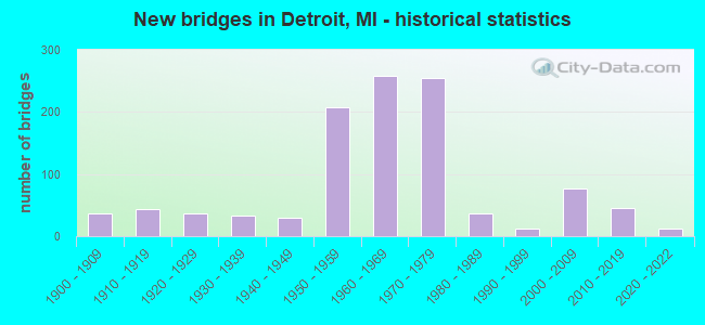
- New bridges - historical statistics
- 1Before 1900
- 371900-1909
- 431910-1919
- 371920-1929
- 331930-1939
- 291940-1949
- 2071950-1959
- 2591960-1969
- 2551970-1979
- 361980-1989
- 131990-1999
- 762000-2009
- 462010-2019
- 132020-2022
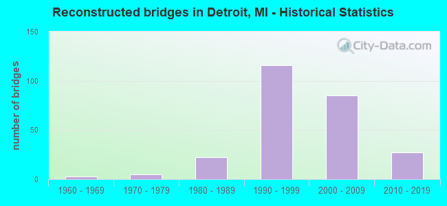
- Reconstructed bridges - Historical Statistics
- 31960-1969
- 51970-1979
- 221980-1989
- 1161990-1999
- 852000-2009
- 272010-2019
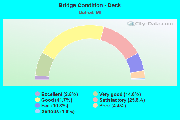
- Bridge Condition - Deck
- 2.5%Excellent
- 14.0%Very good
- 41.7%Good
- 25.6%Satisfactory
- 10.8%Fair
- 4.4%Poor
- 1.0%Serious
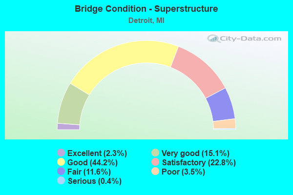
- Bridge Condition - Superstructure
- 2.3%Excellent
- 15.1%Very good
- 44.2%Good
- 22.8%Satisfactory
- 11.6%Fair
- 3.5%Poor
- 0.4%Serious
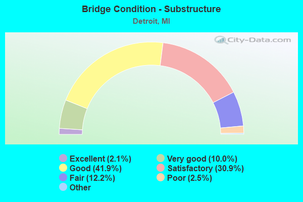
- Bridge Condition - Substructure
- 2.1%Excellent
- 10.0%Very good
- 41.9%Good
- 30.9%Satisfactory
- 12.2%Fair
- 2.5%Poor
- 0.4%Serious
- 0.2%Failed
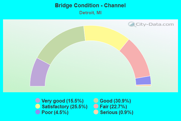
- Bridge Condition - Channel
- 15.5%Very good
- 30.9%Good
- 25.5%Satisfactory
- 22.7%Fair
- 4.5%Poor
- 0.9%Serious
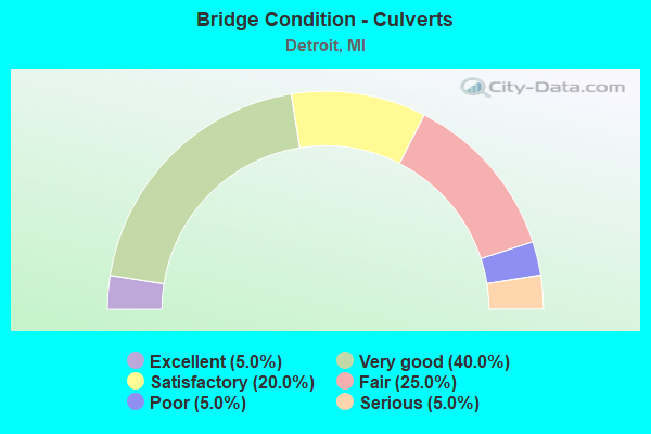
- Bridge Condition - Culverts
- 5.0%Excellent
- 40.0%Very good
- 20.0%Satisfactory
- 25.0%Fair
- 5.0%Poor
- 5.0%Serious
Find on map >> Show street view
Structure Number: 12206, Location: DETROIT N/I-96 (Lat: 42.379814, Lng: -83.198042), Route carried "on" structure: County highway 2000, Year Built: 1970, Year Reconstructed: 1993, Status: Open, Structure Length: 16.63m (54.56ft), Average Daily Traffic: 42,086 (year 2001), Truck Traffic: 5%, Average Future Daily Traffic: 40,000 (year 2015), Design Load: HS 20+Mod, Features Intersected: CSX RR & FULLERTON RD, Facility Carried by Structure: GREENFIELD ROAD
Minimum Vertical Clearance: 30.48m (100.00ft), Kilometerpoint: 0.333, Lanes on structure: 7, Lanes under structure: 2, Base Highway Network: Yes (Inventory Route: 470, Subroute: 92), Owner: County Highway Agency, Approaching Roadway Width: 24.7m (81.0ft), Material/Design: Steel, Design/Construction: Stringer/Multi-beam, Number Of Spans In Main Unit: 8, Length of Maximum Span: 22.5m (73.8ft), Curb or Sidewalk Widths: Left: 3.0m (9.8ft), Right: 3.0m (9.8ft), Curb-To-Curb Width: 24.7m (81.0ft), Out-to-Out Width: 31.4m (103.0ft)
Condition: Deck: Fair, Superstructure: Satisfactory, Substructure: Good, Operating Rating: 66.4 metric tons, Method Used To Determine Operating Rating: Load Factor (LF) rating reported by rating factor (RF) method using MS18 loading, Inventory Rating: 39.9 metric tons, Method Used To Determine Inventory Rating: Load Factor (LF) rating reported by rating factor (RF) method using MS18 loading, Structural Evaluation: Equal to present minimum criteria, Deck Geometry: High priority of replacement, Underclear: Equal to present minimum criteria, Approach Roadway Alignment: Equal to present desirable criteria, Designated Inspection Frequency: Every 12 months, Inspection Date: May 2021, Deck Structure Type: Concrete Cast-file-Place, Wearing Surface/Protective System: Wearing Surface: Integral Concrete, Deck Protection: Epoxy Coated Reinforcing
Find on map >> Show street view
Structure Number: 12214, Location: DET&RIVRRGEN/SCHAEFER (Lat: 42.280956, Lng: -83.128650), Route carried "on" structure: County highway 2057, Year Built: 1922, Year Reconstructed: 1982, Status: Open, Structure Length: 7.56m (24.80ft), Average Daily Traffic: 10,938 (year 1999), Truck Traffic: 7%, Average Future Daily Traffic: 9,442 (year 2015), Design Load: HS 20+Mod, Features Intersected: ROUGE RIVER, Facility Carried by Structure: JEFFERSON AVENUE
Minimum Vertical Clearance: 30.48m (100.00ft), Kilometerpoint: 28.422, Lanes on structure: 4, Base Highway Network: Yes (Inventory Route: 430, Subroute: 69), Owner: County Highway Agency, Approaching Roadway Width: 28.0m (91.9ft), Navigation Control: Yes ( Vertical Clearance: 3.0m (9.8ft), Horizontal Clearance: 21.3m (69.9ft)), Material/Design: Steel, Design/Construction: Movable - Bascule, Number Of Spans In Main Unit: 2, Number Of Approach Spans: 4, Length of Maximum Span: 27.7m (90.9ft), Curb or Sidewalk Widths: Left: 2.6m (8.5ft), Right: 2.6m (8.5ft), Curb-To-Curb Width: 14.0m (45.9ft), Out-to-Out Width: 21.3m (69.9ft)
Condition: Deck: Satisfactory, Superstructure: Poor, Substructure: Fair, Channel: Good, Operating Rating: 46.0 metric tons, Method Used To Determine Operating Rating: Load and Resistance Factor Rating (LRFR) rating reported by rating factor(RF) method using HL-93 loadings, Inventory Rating: 35.3 metric tons, Method Used To Determine Inventory Rating: Load and Resistance Factor Rating (LRFR) rating reported by rating factor(RF) method using HL-93 loadings, Structural Evaluation: Meets minimum limits, Deck Geometry: High priority of replacement, Waterway Adequacy: Equal to present desirable criteria, Approach Roadway Alignment: Equal to present minimum criteria, Designated Inspection Frequency: Every 12 months, Critical Feature Inspection Frequency: Every 24 months, Underwater Inspection Frequency: Every 60 months, Inspection Date: June 2021, Critical Feature Inspection Date: June 2021, Underwater Inspection Date: June 2018, Deck Structure Type: Open Grating, Wearing Surface/Protective System: Wearing Surface: Other, Deck Protection: Cathodic Protection
Find on map >> Show street view
Structure Number: 12343, Location: JEFFERSON W OF ST AUBIN (Lat: 42.335847, Lng: -83.028189), Route carried "on" structure: City street 2000, Year Built: 1923, Year Reconstructed: 2006, Status: Open, Structure Length: 2.89m (9.48ft), Average Daily Traffic: 24,127 (year 2008), Truck Traffic: 3%, Average Future Daily Traffic: 31,900 (year 2024), Design Load: HS 25 or greater, Features Intersected: DEQUINDRE CUT GREENWAY, Facility Carried by Structure: JEFFERSON AVE
Minimum Vertical Clearance: 30.48m (100.00ft), Kilometerpoint: 1.040, Lanes on structure: 9, Base Highway Network: Yes (Inventory Route: 470, Subroute: 24), Owner: City or Municipal Highway Agency, Approaching Roadway Width: 27.4m (89.9ft), Material/Design: Prestressed concrete, Design/Construction: Stringer/Multi-beam, Number Of Spans In Main Unit: 1, Length of Maximum Span: 28.1m (92.2ft), Curb or Sidewalk Widths: Left: 2.8m (9.2ft), Right: 2.8m (9.2ft), Curb-To-Curb Width: 30.2m (99.1ft), Out-to-Out Width: 36.6m (120.1ft)
Condition: Deck: Very good, Superstructure: Very good, Substructure: Good, Operating Rating: 70.3 metric tons, Method Used To Determine Operating Rating: Load Factor (LF) rating reported by rating factor (RF) method using MS18 loading, Inventory Rating: 31.8 metric tons, Method Used To Determine Inventory Rating: Load Factor (LF) rating reported by rating factor (RF) method using MS18 loading, Structural Evaluation: Better than present minimum criteria, Deck Geometry: High priority of replacement, Underclear: High priority of corrective action, Approach Roadway Alignment: Equal to present desirable criteria, Designated Inspection Frequency: Every 24 months, Inspection Date: December 2020, Deck Structure Type: Concrete Cast-file-Place, Wearing Surface/Protective System: Wearing Surface: Integral Concrete
Find on map >> Show street view
Structure Number: 12344, Location: E OF BEAUFAIT (Lat: 42.345044, Lng: -83.006828), Route carried "on" structure: City street 2000, Year Built: 2016, Status: Open, Structure Length: 0.74m (2.43ft), Average Daily Traffic: 24,850 (year 2013), Truck Traffic: 5%, Average Future Daily Traffic: 44,880 (year 2034), Design Load: Greater than HL93, Features Intersected: CONRAIL (ABN), Facility Carried by Structure: JEFFERSON AVENUE
Minimum Vertical Clearance: 30.48m (100.00ft), Kilometerpoint: 3.074, Lanes on structure: 7, Base Highway Network: Yes (Inventory Route: 470, Subroute: 24), Owner: City or Municipal Highway Agency, Approaching Roadway Width: 27.4m (89.9ft), Material/Design: Concrete, Design/Construction: Culvert, Number Of Spans In Main Unit: 1, Length of Maximum Span: 6.7m (22.0ft), Curb or Sidewalk Widths: Left: 3.3m (10.8ft), Right: 3.3m (10.8ft), Curb-To-Curb Width: 27.4m (89.9ft), Out-to-Out Width: 34.5m (113.2ft)
Condition: Culverts: Very good, Operating Rating: 49.9 metric tons, Method Used To Determine Operating Rating: Load and Resistance Factor Rating (LRFR) rating reported by rating factor(RF) method using HL-93 loadings, Inventory Rating: 38.6 metric tons, Method Used To Determine Inventory Rating: Load and Resistance Factor Rating (LRFR) rating reported by rating factor(RF) method using HL-93 loadings, Structural Evaluation: Equal to present desirable criteria, Deck Geometry: Somewhat better than minimum adequacy, Approach Roadway Alignment: Equal to present desirable criteria, Designated Inspection Frequency: Every 24 months, Inspection Date: November 2020, Wearing Surface/Protective System: Wearing Surface: Low Slump Concrete
Find on map >> Show street view
Structure Number: 12345, Location: MT ELLIOTT - MOUND RD (Lat: 42.404322, Lng: -83.038067), Route carried "on" structure: City street 2000, Year Built: 1969, Year Reconstructed: 1996, Status: Open, Structure Length: 48.02m (157.55ft), Average Daily Traffic: 12,856 (year 2008), Truck Traffic: 5%, Average Future Daily Traffic: 35,058 (year 2021), Design Load: HS 20+Mod, Features Intersected: GTW RR AND CANIFF, Facility Carried by Structure: MT ELLIOTT - MOUND
Minimum Vertical Clearance: 30.48m (100.00ft), Kilometerpoint: 0.682, Lanes on structure: 4, Lanes under structure: 4, Base Highway Network: Yes (Inventory Route: 470, Subroute: 16), Owner: City or Municipal Highway Agency, Approaching Roadway Width: 15.2m (49.9ft), Skew: 39 degrees, Material/Design: Steel, Design/Construction: Stringer/Multi-beam, Number Of Spans In Main Unit: 16, Length of Maximum Span: 37.8m (124.0ft), Curb or Sidewalk Widths: Left: 0.0m, Right: 1.4m (4.6ft), Curb-To-Curb Width: 15.2m (49.9ft), Out-to-Out Width: 18.3m (60.0ft)
Condition: Deck: Satisfactory, Superstructure: Satisfactory, Substructure: Fair, Operating Rating: 69.0 metric tons, Method Used To Determine Operating Rating: Load Factor (LF) rating reported by rating factor (RF) method using MS18 loading, Inventory Rating: 41.5 metric tons, Method Used To Determine Inventory Rating: Load Factor (LF) rating reported by rating factor (RF) method using MS18 loading, Structural Evaluation: Somewhat better than minimum adequacy, Deck Geometry: High priority of corrective action, Underclear: High priority of corrective action, Approach Roadway Alignment: Equal to present desirable criteria, Length Of Structure Improvement: 48.02m (157.55ft), Designated Inspection Frequency: Every 24 months, Critical Feature Inspection Frequency: Every 24 months, Inspection Date: July 2020, Critical Feature Inspection Date: July 2020, Bridge Improvement Cost: $9,358,000, Roadway Improvement Cost: $300,000, Total Project Cost: $9,658,000, Deck Structure Type: Concrete Cast-file-Place, Wearing Surface/Protective System: Wearing Surface: Monolithic Concrete, Deck Protection: Epoxy Coated Reinforcing
Find on map >> Show street view
Structure Number: 12347, Location: FORT ST (Lat: 42.284664, Lng: -83.148206), Route carried "on" structure: State highway 85, Year Built: 2010, Status: Open, Structure Length: 11.99m (39.34ft), Average Daily Traffic: 5,981 (year 2007), Truck Traffic: 12%, Average Future Daily Traffic: 8,000 (year 2028), Design Load: Greater than HL93, Features Intersected: NORFOLK WESTERN RR
Minimum Vertical Clearance: 30.48m (100.00ft), Kilometerpoint: 0.827, Lanes on structure: 6, Base Highway Network: Yes (Inventory Route: 470, Subroute: 47), Owner: State Highway Agency, Approaching Roadway Width: 24.3m (79.7ft), Skew: 5 degrees, Material/Design: Steel continuous, Design/Construction: Stringer/Multi-beam, Number Of Spans In Main Unit: 3, Length of Maximum Span: 46.7m (153.2ft), Curb or Sidewalk Widths: Left: 4.3m (14.1ft), Right: 1.8m (5.9ft), Curb-To-Curb Width: 24.4m (80.1ft), Out-to-Out Width: 32.3m (106.0ft)
Condition: Deck: Good, Superstructure: Very good, Substructure: Good, Operating Rating: 64.6 metric tons, Method Used To Determine Operating Rating: Load Factor (LF), Inventory Rating: 38.8 metric tons, Method Used To Determine Inventory Rating: Load Factor (LF), Structural Evaluation: Better than present minimum criteria, Deck Geometry: Somewhat better than minimum adequacy, Underclear: Equal to present desirable criteria, Approach Roadway Alignment: Equal to present desirable criteria, Designated Inspection Frequency: Every 24 months, Inspection Date: May 2020, Deck Structure Type: Concrete Cast-file-Place, Wearing Surface/Protective System: Wearing Surface: Monolithic Concrete, Deck Protection: Epoxy Coated Reinforcing
Find on map >> Show street view
Structure Number: 12363, Location: LAFAYETTE AT TWELFTH ST (Lat: 42.323492, Lng: -83.066914), Route carried "on" structure: Alternate City street 2000, Year Built: 1984, Year Reconstructed: 2016, Status: Open, Structure Length: 3.82m (12.53ft), Average Daily Traffic: 3,500 (year 2015), Truck Traffic: 3%, Average Future Daily Traffic: 4,025 (year 2035), Design Load: HS 20+Mod, Features Intersected: CONRAIL, Facility Carried by Structure: LAFAYETTE STREET
Minimum Vertical Clearance: 30.48m (100.00ft), Kilometerpoint: 0.896, Lanes on structure: 4, Owner: City or Municipal Highway Agency, Approaching Roadway Width: 17.4m (57.1ft), Skew: 3 degrees, Material/Design: Steel, Design/Construction: Stringer/Multi-beam, Number Of Spans In Main Unit: 2, Length of Maximum Span: 22.8m (74.8ft), Curb or Sidewalk Widths: Left: 3.0m (9.8ft), Right: 3.0m (9.8ft), Curb-To-Curb Width: 17.4m (57.1ft), Out-to-Out Width: 24.1m (79.1ft)
Condition: Deck: Fair, Superstructure: Good, Substructure: Good, Operating Rating: 72.6 metric tons, Method Used To Determine Operating Rating: Load and Resistance Factor Rating (LRFR) rating reported by rating factor(RF) method using HL-93 loadings, Inventory Rating: 56.1 metric tons, Method Used To Determine Inventory Rating: Load and Resistance Factor Rating (LRFR) rating reported by rating factor(RF) method using HL-93 loadings, Structural Evaluation: Better than present minimum criteria, Deck Geometry: Somewhat better than minimum adequacy, Underclear: High priority of corrective action, Approach Roadway Alignment: Equal to present desirable criteria, Designated Inspection Frequency: Every 24 months, Inspection Date: December 2021, Deck Structure Type: Concrete Cast-file-Place, Wearing Surface/Protective System: Wearing Surface: Integral Concrete, Deck Protection: Epoxy Coated Reinforcing
Find on map >> Show street view
Structure Number: 1237, Location: TWELFTH ST N OF LAFAYETTE (Lat: 42.323669, Lng: -83.067378), Route carried "on" structure: City street 2000, Year Built: 1984, Status: Open, Structure Length: 4.90m (16.08ft), Average Daily Traffic: 8,000 (year 2015), Truck Traffic: 3%, Average Future Daily Traffic: 9,200 (year 2035), Design Load: HS 20, Features Intersected: CONRAIL, Facility Carried by Structure: TWELFTH STREET
Minimum Vertical Clearance: 30.48m (100.00ft), Kilometerpoint: 0.270, Lanes on structure: 6, Owner: City or Municipal Highway Agency, Approaching Roadway Width: 28.0m (91.9ft), Skew: 34 degrees, Material/Design: Steel, Design/Construction: Stringer/Multi-beam, Number Of Spans In Main Unit: 2, Length of Maximum Span: 29.5m (96.8ft), Curb or Sidewalk Widths: Left: 3.0m (9.8ft), Right: 3.0m (9.8ft), Curb-To-Curb Width: 27.7m (90.9ft), Out-to-Out Width: 34.7m (113.8ft)
Condition: Deck: Good, Superstructure: Good, Substructure: Good, Operating Rating: 72.3 metric tons, Method Used To Determine Operating Rating: Load Factor (LF) rating reported by rating factor (RF) method using MS18 loading, Inventory Rating: 43.1 metric tons, Method Used To Determine Inventory Rating: Load Factor (LF) rating reported by rating factor (RF) method using MS18 loading, Structural Evaluation: Better than present minimum criteria, Deck Geometry: Equal to present desirable criteria, Underclear: High priority of corrective action, Approach Roadway Alignment: Equal to present desirable criteria, Designated Inspection Frequency: Every 24 months, Inspection Date: December 2021, Deck Structure Type: Concrete Cast-file-Place, Wearing Surface/Protective System: Wearing Surface: Integral Concrete, Deck Protection: Epoxy Coated Reinforcing
Find on map >> Show street view
Structure Number: 1238, Location: W OF ST AUBIN (Lat: 42.336572, Lng: -83.028678), Route carried "on" structure: Alternate City street 2000, Year Built: 1923, Year Reconstructed: 2010, Status: Open, Structure Length: 2.51m (8.23ft), Average Daily Traffic: 15,014 (year 2009), Truck Traffic: 5%, Average Future Daily Traffic: 27,117 (year 2029), Design Load: HS 20+Mod, Features Intersected: DEQUINDRE CUT GREENWAY, Facility Carried by Structure: LARNED STREET
Minimum Vertical Clearance: 30.48m (100.00ft), Kilometerpoint: 0.681, Lanes on structure: 6, Owner: City or Municipal Highway Agency, Approaching Roadway Width: 27.4m (89.9ft), Skew: 20 degrees, Material/Design: Steel continuous, Design/Construction: Stringer/Multi-beam, Number Of Spans In Main Unit: 3, Length of Maximum Span: 9.6m (31.5ft), Curb or Sidewalk Widths: Left: 3.3m (10.8ft), Right: 3.3m (10.8ft), Curb-To-Curb Width: 20.1m (65.9ft), Out-to-Out Width: 34.7m (113.8ft)
Condition: Deck: Good, Superstructure: Very good, Substructure: Satisfactory, Operating Rating: 97.2 metric tons, Method Used To Determine Operating Rating: Load and Resistance Factor Rating (LRFR) rating reported by rating factor(RF) method using HL-93 loadings, Inventory Rating: 63.5 metric tons, Method Used To Determine Inventory Rating: Load and Resistance Factor Rating (LRFR) rating reported by rating factor(RF) method using HL-93 loadings, Structural Evaluation: Equal to present minimum criteria, Deck Geometry: High priority of replacement, Underclear: High priority of corrective action, Approach Roadway Alignment: Equal to present desirable criteria, Designated Inspection Frequency: Every 24 months, Inspection Date: December 2021, Deck Structure Type: Concrete Cast-file-Place, Wearing Surface/Protective System: Wearing Surface: Monolithic Concrete, Deck Protection: Epoxy Coated Reinforcing
Find on map >> Show street view
Structure Number: 12381, Location: W OF ST AUBIN (Lat: 42.338914, Lng: -83.030272), Route carried "on" structure: Alternate City street 2000, Year Built: 1924, Year Reconstructed: 2009, Status: Open, Structure Length: 2.01m (6.59ft), Average Daily Traffic: 13,709 (year 2009), Truck Traffic: 5%, Average Future Daily Traffic: 24,759 (year 2029), Design Load: HS 20+Mod, Features Intersected: DEQUINDRE CUT GREENWAY, Facility Carried by Structure: LAFAYETTE STREET
Minimum Vertical Clearance: 30.48m (100.00ft), Kilometerpoint: 1.313, Lanes on structure: 6, Owner: City or Municipal Highway Agency, Approaching Roadway Width: 27.4m (89.9ft), Skew: 20 degrees, Material/Design: Steel continuous, Design/Construction: Stringer/Multi-beam, Number Of Spans In Main Unit: 2, Length of Maximum Span: 10.1m (33.1ft), Curb or Sidewalk Widths: Left: 3.3m (10.8ft), Right: 3.3m (10.8ft), Curb-To-Curb Width: 20.1m (65.9ft), Out-to-Out Width: 34.7m (113.8ft)
Condition: Deck: Good, Superstructure: Very good, Substructure: Satisfactory, Operating Rating: 97.2 metric tons, Method Used To Determine Operating Rating: Load and Resistance Factor Rating (LRFR) rating reported by rating factor(RF) method using HL-93 loadings, Inventory Rating: 61.6 metric tons, Method Used To Determine Inventory Rating: Load and Resistance Factor Rating (LRFR) rating reported by rating factor(RF) method using HL-93 loadings, Structural Evaluation: Equal to present minimum criteria, Deck Geometry: High priority of replacement, Approach Roadway Alignment: Equal to present desirable criteria, Designated Inspection Frequency: Every 24 months, Inspection Date: December 2021, Deck Structure Type: Concrete Cast-file-Place, Wearing Surface/Protective System: Wearing Surface: Bituminous
Find on map >> Show street view
Structure Number: 12391, Location: W OF ST AUBIN (Lat: 42.376936, Lng: -83.055217), Route carried "on" structure: City street 2000, Year Built: 1973, Year Reconstructed: 2008, Status: Open, Structure Length: 14.87m (48.79ft), Average Daily Traffic: 3,729 (year 2005), Truck Traffic: 5%, Average Future Daily Traffic: 6,710 (year 2025), Design Load: HS 20+Mod, Features Intersected: GTW RR & RIVARD ST, Facility Carried by Structure: E GRAND BOULEVARD
Minimum Vertical Clearance: 30.48m (100.00ft), Kilometerpoint: 7.825, Lanes on structure: 6, Lanes under structure: 7, Owner: City or Municipal Highway Agency, Approaching Roadway Width: 41.4m (135.8ft), Skew: 30 degrees, Material/Design: Steel continuous, Design/Construction: Stringer/Multi-beam, Number Of Spans In Main Unit: 6, Length of Maximum Span: 29.9m (98.1ft), Curb or Sidewalk Widths: Left: 1.8m (5.9ft), Right: 1.8m (5.9ft), Curb-To-Curb Width: 22.0m (72.2ft), Out-to-Out Width: 27.1m (88.9ft)
Condition: Deck: Good, Superstructure: Satisfactory, Substructure: Satisfactory, Operating Rating: 40.5 metric tons, Method Used To Determine Operating Rating: Load and Resistance Factor Rating (LRFR) rating reported by rating factor(RF) method using HL-93 loadings, Inventory Rating: 33.4 metric tons, Method Used To Determine Inventory Rating: Load and Resistance Factor Rating (LRFR) rating reported by rating factor(RF) method using HL-93 loadings, Structural Evaluation: Equal to present minimum criteria, Deck Geometry: High priority of corrective action, Underclear: Equal to present minimum criteria, Approach Roadway Alignment: Superior to present desirable criteria, Designated Inspection Frequency: Every 24 months, Inspection Date: December 2021, Deck Structure Type: Concrete Cast-file-Place, Wearing Surface/Protective System: Wearing Surface: Monolithic Concrete, Deck Protection: Epoxy Coated Reinforcing
Find on map >> Show street view
Structure Number: 12392, Location: DETROIT RIV AT BELLE ISLE (Lat: 42.340078, Lng: -82.996661), Route carried "on" structure: State highway 700, Year Built: 1929, Year Reconstructed: 1998, Status: Posted for load, Structure Length: 66.86m (219.36ft), Average Daily Traffic: 5,450 (year 2018), Truck Traffic: 1%, Average Future Daily Traffic: 6,025 (year 2038), Design Load: HS 20+Mod, Features Intersected: DETROIT RIVER, Facility Carried by Structure: BELLE ISLE TRAFFIC
Minimum Vertical Clearance: 30.48m (100.00ft), Kilometerpoint: 0.267, Lanes on structure: 5, Owner: State Highway Agency, Approaching Roadway Width: 18.7m (61.4ft), Material/Design: Concrete, Number Of Spans In Main Unit: 19, Number Of Approach Spans: 1, Length of Maximum Span: 41.1m (134.8ft), Curb or Sidewalk Widths: Left: 3.1m (10.2ft), Right: 3.1m (10.2ft), Curb-To-Curb Width: 18.7m (61.4ft), Out-to-Out Width: 26.8m (87.9ft)
Condition: Deck: Fair, Superstructure: Fair, Substructure: Fair, Channel: Good, Operating Rating: 40.5 metric tons, Method Used To Determine Operating Rating: Load Factor (LF) rating reported by rating factor (RF) method using MS18 loading, Inventory Rating: 24.3 metric tons, Method Used To Determine Inventory Rating: Load Factor (LF) rating reported by rating factor (RF) method using MS18 loading, Structural Evaluation: Somewhat better than minimum adequacy, Deck Geometry: High priority of corrective action, Waterway Adequacy: Equal to present desirable criteria, Approach Roadway Alignment: Superior to present desirable criteria, Bridge Posting: Required (Relationship of Operating Rating to Maximum Legal Load: 20.0 - 29.9% below), Designated Inspection Frequency: Every 24 months, Underwater Inspection Frequency: Every 60 months, Inspection Date: August 2021, Underwater Inspection Date: September 2019, Bridge Improvement Cost: $63,852,000, Roadway Improvement Cost: $461,000, Total Project Cost: $64,313,000, Deck Structure Type: Concrete Cast-file-Place, Wearing Surface/Protective System: Wearing Surface: Epoxy Overlay, Deck Protection: Epoxy Coated Reinforcing
Find on map >> Show street view
Structure Number: 12393, Location: WEST OF FOURTEENTH ST (Lat: 42.326439, Lng: -83.074672), Route carried "on" structure: Alternate City street 2000, Year Built: 1978, Status: Open, Structure Length: 8.47m (27.79ft), Average Daily Traffic: 3,539 (year 2008), Truck Traffic: 3%, Average Future Daily Traffic: 2,476 (year 2023), Design Load: HS 20, Features Intersected: CONRAIL, Facility Carried by Structure: BAGLEY
Minimum Vertical Clearance: 30.48m (100.00ft), Kilometerpoint: 0.639, Lanes on structure: 4, Owner: City or Municipal Highway Agency, Approaching Roadway Width: 16.5m (54.1ft), Skew: 4 degrees, Material/Design: Steel, Design/Construction: Stringer/Multi-beam, Number Of Spans In Main Unit: 4, Length of Maximum Span: 25.3m (83.0ft), Curb or Sidewalk Widths: Left: 3.2m (10.5ft), Right: 3.2m (10.5ft), Curb-To-Curb Width: 16.5m (54.1ft), Out-to-Out Width: 23.7m (77.8ft)
Condition: Deck: Very good, Superstructure: Good, Substructure: Good, Operating Rating: 74.2 metric tons, Method Used To Determine Operating Rating: Load Factor (LF) rating reported by rating factor (RF) method using MS18 loading, Inventory Rating: 44.4 metric tons, Method Used To Determine Inventory Rating: Load Factor (LF) rating reported by rating factor (RF) method using MS18 loading, Structural Evaluation: Better than present minimum criteria, Deck Geometry: Meets minimum limits, Underclear: High priority of corrective action, Approach Roadway Alignment: Equal to present minimum criteria, Designated Inspection Frequency: Every 24 months, Inspection Date: March 2022, Deck Structure Type: Concrete Cast-file-Place, Wearing Surface/Protective System: Wearing Surface: Monolithic Concrete
Find on map >> Show street view
Structure Number: 12426, Location: BETWEEN ALTER AND ASHLAND (Lat: 42.364861, Lng: -82.933117), Route carried "on" structure: ServiceCity street , Year Built: 2004, Status: Open, Structure Length: 1.16m (3.81ft), Average Daily Traffic: 1,536 (year 2005), Truck Traffic: 1%, Average Future Daily Traffic: 2,765 (year 2025), Design Load: HS 20, Features Intersected: FOX CREEK, Facility Carried by Structure: KORTE AVE
Minimum Vertical Clearance: 30.48m (100.00ft), Kilometerpoint: 1.082, Lanes on structure: 2, Owner: City or Municipal Highway Agency, Approaching Roadway Width: 7.9m (25.9ft), Material/Design: Concrete, Design/Construction: Arch - Deck, Number Of Spans In Main Unit: 1, Length of Maximum Span: 10.6m (34.8ft), Curb or Sidewalk Widths: Left: 1.8m (5.9ft), Right: 1.8m (5.9ft), Curb-To-Curb Width: 8.5m (27.9ft), Out-to-Out Width: 12.8m (42.0ft)
Condition: Deck: Good, Superstructure: Good, Substructure: Good, Channel: Satisfactory, Operating Rating: 33.0 metric tons, Method Used To Determine Operating Rating: Field evaluation and documented engineering judgment, Inventory Rating: 33.0 metric tons, Method Used To Determine Inventory Rating: Field evaluation and documented engineering judgment, Structural Evaluation: Better than present minimum criteria, Deck Geometry: Somewhat better than minimum adequacy, Waterway Adequacy: Superior to present desirable criteria, Approach Roadway Alignment: Better than present minimum criteria, Length Of Structure Improvement: 1.13m (3.71ft), Designated Inspection Frequency: Every 24 months, Underwater Inspection Frequency: Every 60 months, Inspection Date: December 2021, Underwater Inspection Date: November 2021, Bridge Improvement Cost: $284,000, Roadway Improvement Cost: $50,000, Total Project Cost: $426,000, Deck Structure Type: Concrete Cast-file-Place, Wearing Surface/Protective System: Wearing Surface: Monolithic Concrete
Find on map >> Show street view
Structure Number: 12427, Location: BETWN ORLEANS & ST AUBIN (Lat: 42.344725, Lng: -83.034150), Route carried "on" structure: City street , Year Built: 1929, Status: Posted for load, Structure Length: 2.01m (6.59ft), Average Daily Traffic: 1,398 (year 2008), Average Future Daily Traffic: 5,909 (year 2023), Design Load: H 15, Features Intersected: DEQUINDRE CUT GREENWAY, Facility Carried by Structure: CHESTNUT
Minimum Vertical Clearance: 30.48m (100.00ft), Kilometerpoint: 0.101, Lanes on structure: 2, Owner: City or Municipal Highway Agency, Approaching Roadway Width: 7.9m (25.9ft), Material/Design: Steel, Design/Construction: Stringer/Multi-beam, Number Of Spans In Main Unit: 2, Length of Maximum Span: 9.4m (30.8ft), Curb or Sidewalk Widths: Left: 2.5m (8.2ft), Right: 2.5m (8.2ft), Curb-To-Curb Width: 9.1m (29.9ft), Out-to-Out Width: 15.3m (50.2ft)
Condition: Deck: Serious, Superstructure: Poor, Substructure: Serious, Operating Rating: 64.5 metric tons, Method Used To Determine Operating Rating: Load and Resistance Factor Rating (LRFR) rating reported by rating factor(RF) method using HL-93 loadings, Inventory Rating: 38.6 metric tons, Method Used To Determine Inventory Rating: Load and Resistance Factor Rating (LRFR) rating reported by rating factor(RF) method using HL-93 loadings, Structural Evaluation: High priority of corrective action, Deck Geometry: Somewhat better than minimum adequacy, Underclear: High priority of corrective action, Approach Roadway Alignment: Equal to present minimum criteria, Bridge Posting: Required (Relationship of Operating Rating to Maximum Legal Load: 30.0 - 39.9% below), Designated Inspection Frequency: Every 12 months, Inspection Date: June 2021, Deck Structure Type: Concrete Cast-file-Place, Wearing Surface/Protective System: Wearing Surface: Bituminous
Find on map >> Show street view
Structure Number: 12428, Location: BETWN ORLEANS & ST AUBIN (Lat: 42.345422, Lng: -83.034597), Route carried "on" structure: City street , Year Built: 2007, Status: Open, Structure Length: 2.76m (9.06ft), Average Daily Traffic: 1,433 (year 1997), Truck Traffic: 5%, Average Future Daily Traffic: 2,545 (year 2026), Design Load: HS 20+Mod, Features Intersected: DEQUINDRE CUT GREENWAY, Facility Carried by Structure: ANTIETAM AVE
Minimum Vertical Clearance: 30.48m (100.00ft), Kilometerpoint: 1.025, Lanes on structure: 2, Owner: City or Municipal Highway Agency, Approaching Roadway Width: 9.1m (29.9ft), Material/Design: Concrete, Design/Construction: Culvert, Number Of Spans In Main Unit: 2, Length of Maximum Span: 13.8m (45.3ft), Curb or Sidewalk Widths: Left: 2.6m (8.5ft), Right: 2.6m (8.5ft), Curb-To-Curb Width: 9.1m (29.9ft), Out-to-Out Width: 14.9m (48.9ft)
Condition: Culverts: Very good, Operating Rating: 57.3 metric tons, Method Used To Determine Operating Rating: Load and Resistance Factor Rating (LRFR) rating reported by rating factor(RF) method using HL-93 loadings, Inventory Rating: 34.3 metric tons, Method Used To Determine Inventory Rating: Load and Resistance Factor Rating (LRFR) rating reported by rating factor(RF) method using HL-93 loadings, Structural Evaluation: Equal to present desirable criteria, Deck Geometry: Somewhat better than minimum adequacy, Approach Roadway Alignment: Equal to present minimum criteria, Designated Inspection Frequency: Every 24 months, Inspection Date: December 2021, Deck Structure Type: Concrete Cast-file-Place, Wearing Surface/Protective System: Wearing Surface: Integral Concrete
Find on map >> Show street view
Structure Number: 12442, Location: ROUGE PARK (Lat: 42.352325, Lng: -83.251983), Route carried "on" structure: City street , Year Built: 1930, Year Reconstructed: 1998, Status: Open, Structure Length: 2.74m (8.99ft), Average Daily Traffic: 2,558 (year 2008), Truck Traffic: 5%, Average Future Daily Traffic: 4,218 (year 2023), Design Load: HS 20+Mod, Features Intersected: ROUGE RIVER, Facility Carried by Structure: TIREMAN AVE
Minimum Vertical Clearance: 30.48m (100.00ft), Kilometerpoint: 0.245, Lanes on structure: 4, Owner: City or Municipal Highway Agency, Approaching Roadway Width: 15.2m (49.9ft), Skew: 2 degrees, Material/Design: Prestressed concrete, Design/Construction: Stringer/Multi-beam, Number Of Spans In Main Unit: 2, Length of Maximum Span: 13.7m (44.9ft), Curb or Sidewalk Widths: Left: 2.7m (8.9ft), Right: 2.7m (8.9ft), Curb-To-Curb Width: 15.2m (49.9ft), Out-to-Out Width: 21.3m (69.9ft)
Condition: Deck: Good, Superstructure: Good, Substructure: Satisfactory, Channel: Good, Operating Rating: 32.4 metric tons, Method Used To Determine Operating Rating: Field evaluation and documented engineering judgment, Inventory Rating: 32.0 metric tons, Method Used To Determine Inventory Rating: Field evaluation and documented engineering judgment, Structural Evaluation: Equal to present minimum criteria, Deck Geometry: High priority of corrective action, Waterway Adequacy: Better than present minimum criteria, Approach Roadway Alignment: Better than present minimum criteria, Designated Inspection Frequency: Every 24 months, Inspection Date: December 2021, Deck Structure Type: Concrete Cast-file-Place, Wearing Surface/Protective System: Wearing Surface: Monolithic Concrete
Find on map >> Show street view
Structure Number: 12443, Location: ROUGE PARK (Lat: 42.371694, Lng: -83.255483), Route carried "on" structure: City street , Year Built: 1959, Year Reconstructed: 1983, Status: Open, Structure Length: 3.62m (11.88ft), Average Daily Traffic: 9,565 (year 2005), Truck Traffic: 5%, Average Future Daily Traffic: 17,215 (year 2025), Design Load: HS 25 or greater, Features Intersected: ROUGE RIVER, Facility Carried by Structure: PLYMOUTH ROAD
Minimum Vertical Clearance: 30.48m (100.00ft), Kilometerpoint: 24.642, Lanes on structure: 6, Owner: City or Municipal Highway Agency, Approaching Roadway Width: 27.1m (88.9ft), Material/Design: Prestressed concrete, Design/Construction: Stringer/Multi-beam, Number Of Spans In Main Unit: 3, Length of Maximum Span: 12.2m (40.0ft), Curb or Sidewalk Widths: Left: 3.0m (9.8ft), Right: 3.0m (9.8ft), Curb-To-Curb Width: 27.1m (88.9ft), Out-to-Out Width: 33.6m (110.2ft)
Condition: Deck: Fair, Superstructure: Satisfactory, Substructure: Fair, Channel: Fair, Operating Rating: 33.0 metric tons, Method Used To Determine Operating Rating: Field evaluation and documented engineering judgment, Inventory Rating: 33.0 metric tons, Method Used To Determine Inventory Rating: Field evaluation and documented engineering judgment, Structural Evaluation: Somewhat better than minimum adequacy, Deck Geometry: Better than present minimum criteria, Waterway Adequacy: Better than present minimum criteria, Approach Roadway Alignment: Equal to present desirable criteria, Designated Inspection Frequency: Every 24 months, Inspection Date: December 2021, Deck Structure Type: Concrete Cast-file-Place, Wearing Surface/Protective System: Wearing Surface: Integral Concrete, Deck Protection: Epoxy Coated Reinforcing
Find on map >> Show street view
Structure Number: 12446, Location: BETWN ORLEANS & ST AUBIN (Lat: 42.348125, Lng: -83.036411), Route carried "on" structure: City street , Year Built: 2014, Status: Open, Structure Length: 2.09m (6.86ft), Average Daily Traffic: 335 (year 2008), Average Future Daily Traffic: 1,195 (year 2023), Design Load: Greater than HL93, Features Intersected: DEQUINDRE CUT PATHWAY, Facility Carried by Structure: ADELAIDE
Minimum Vertical Clearance: 30.48m (100.00ft), Kilometerpoint: 0.386, Lanes on structure: 2, Owner: City or Municipal Highway Agency, Approaching Roadway Width: 10.4m (34.1ft), Material/Design: Concrete, Design/Construction: Culvert, Number Of Spans In Main Unit: 2, Length of Maximum Span: 9.8m (32.2ft), Curb or Sidewalk Widths: Left: 2.1m (6.9ft), Right: 2.1m (6.9ft), Curb-To-Curb Width: 10.4m (34.1ft), Out-to-Out Width: 15.2m (49.9ft)
Condition: Culverts: Very good, Operating Rating: 66.4 metric tons, Method Used To Determine Operating Rating: Load and Resistance Factor Rating (LRFR) rating reported by rating factor(RF) method using HL-93 loadings, Inventory Rating: 51.2 metric tons, Method Used To Determine Inventory Rating: Load and Resistance Factor Rating (LRFR) rating reported by rating factor(RF) method using HL-93 loadings, Structural Evaluation: Equal to present desirable criteria, Deck Geometry: Better than present minimum criteria, Approach Roadway Alignment: Equal to present desirable criteria, Designated Inspection Frequency: Every 24 months, Inspection Date: November 2020, Wearing Surface/Protective System: Wearing Surface: Integral Concrete
Find on map >> Show street view
Structure Number: 12448, Location: SOUTH OF JEFFERSON (Lat: 42.373425, Lng: -82.939444), Route carried "on" structure: ServiceCity street , Year Built: 2006, Status: Open, Structure Length: 1.29m (4.23ft), Average Daily Traffic: 594 (year 2008), Truck Traffic: 5%, Average Future Daily Traffic: 1,697 (year 2021), Features Intersected: FOX CREEK, Facility Carried by Structure: ASHLAND AVE
Minimum Vertical Clearance: 30.48m (100.00ft), Kilometerpoint: 1.490, Lanes on structure: 2, Owner: City or Municipal Highway Agency, Approaching Roadway Width: 7.9m (25.9ft), Skew: 2 degrees, Material/Design: Concrete, Design/Construction: Arch - Deck, Number Of Spans In Main Unit: 1, Length of Maximum Span: 11.9m (39.0ft), Curb or Sidewalk Widths: Left: 1.8m (5.9ft), Right: 1.8m (5.9ft), Curb-To-Curb Width: 8.5m (27.9ft), Out-to-Out Width: 12.8m (42.0ft)
Condition: Deck: Good, Superstructure: Good, Substructure: Good, Channel: Good, Operating Rating: 54.5 metric tons, Method Used To Determine Operating Rating: Field evaluation and documented engineering judgment, Inventory Rating: 32.7 metric tons, Method Used To Determine Inventory Rating: Field evaluation and documented engineering judgment, Structural Evaluation: Better than present minimum criteria, Deck Geometry: Somewhat better than minimum adequacy, Waterway Adequacy: Better than present minimum criteria, Approach Roadway Alignment: Meets minimum limits, Designated Inspection Frequency: Every 24 months, Underwater Inspection Frequency: Every 60 months, Inspection Date: June 2020, Underwater Inspection Date: November 2021, Deck Structure Type: Concrete Cast-file-Place, Wearing Surface/Protective System: Wearing Surface: Monolithic Concrete
Find on map >> Show street view
Structure Number: 12449, Location: BELLE ISLE (Lat: 42.338103, Lng: -82.996833), Route carried "on" structure: State highway 704, Year Built: 1947, Status: Open, Structure Length: 1.37m (4.49ft), Average Daily Traffic: 1,157 (year 2005), Truck Traffic: 1%, Average Future Daily Traffic: 2,085 (year 2025), Design Load: HS 20+Mod, Features Intersected: CANOE STREAM, Facility Carried by Structure: SUNSET DRIVE
Minimum Vertical Clearance: 30+ m (98+ ft), Kilometerpoint: 0.206, Lanes on structure: 4, Owner: State Highway Agency, Approaching Roadway Width: 11.9m (39.0ft), Material/Design: Concrete, Design/Construction: Frame, Number Of Spans In Main Unit: 1, Length of Maximum Span: 12.2m (40.0ft), Curb or Sidewalk Widths: Left: 1.8m (5.9ft), Right: 1.8m (5.9ft), Curb-To-Curb Width: 11.9m (39.0ft), Out-to-Out Width: 16.4m (53.8ft)
Condition: Deck: Satisfactory, Superstructure: Satisfactory, Substructure: Good, Channel: Good, Operating Rating: 51.1 metric tons, Method Used To Determine Operating Rating: Field evaluation and documented engineering judgment, Inventory Rating: 32.4 metric tons, Method Used To Determine Inventory Rating: Field evaluation and documented engineering judgment, Structural Evaluation: Equal to present minimum criteria, Deck Geometry: High priority of replacement, Waterway Adequacy: Meets minimum limits, Approach Roadway Alignment: Equal to present desirable criteria, Length Of Structure Improvement: 1.22m (4.00ft), Designated Inspection Frequency: Every 24 months, Inspection Date: August 2020, Bridge Improvement Cost: $250,000, Roadway Improvement Cost: $25,000, Total Project Cost: $295,000, Deck Structure Type: Concrete Cast-file-Place, Wearing Surface/Protective System: Wearing Surface: Bituminous
Find on map >> Show street view
Structure Number: 12453, Location: BELLE ISLE (Lat: 42.336658, Lng: -82.994608), Route carried "on" structure: State highway 701, Year Built: 1947, Year Reconstructed: 2008, Status: Open, Structure Length: 1.67m (5.48ft), Average Daily Traffic: 469 (year 2005), Average Future Daily Traffic: 2,128 (year 2021), Design Load: HS 20+Mod, Features Intersected: CANOE STREAM, Facility Carried by Structure: CENTRAL AVE
Minimum Vertical Clearance: 30+ m (98+ ft), Kilometerpoint: 0.068, Lanes on structure: 2, Owner: State Highway Agency, Approaching Roadway Width: 24.1m (79.1ft), Material/Design: Prestressed concrete, Design/Construction: Box Beam or Girders - Multiple, Number Of Spans In Main Unit: 1, Length of Maximum Span: 15.2m (49.9ft), Curb or Sidewalk Widths: Left: 3.8m (12.5ft), Right: 3.8m (12.5ft), Curb-To-Curb Width: 14.9m (48.9ft), Out-to-Out Width: 22.5m (73.8ft)
Condition: Deck: Good, Superstructure: Very good, Substructure: Good, Channel: Very good, Operating Rating: 54.1 metric tons, Method Used To Determine Operating Rating: Field evaluation and documented engineering judgment, Inventory Rating: 32.4 metric tons, Method Used To Determine Inventory Rating: Field evaluation and documented engineering judgment, Structural Evaluation: Better than present minimum criteria, Deck Geometry: Superior to present desirable criteria, Waterway Adequacy: Better than present minimum criteria, Approach Roadway Alignment: Better than present minimum criteria, Designated Inspection Frequency: Every 24 months, Inspection Date: August 2020, Deck Structure Type: Concrete Cast-file-Place, Wearing Surface/Protective System: Wearing Surface: Integral Concrete
Find on map >> Show street view
Structure Number: 12454, Location: BELLE ISLE (Lat: 42.343003, Lng: -82.976264), Route carried "on" structure: State highway 701, Year Built: 1913, Status: Posted for load, Structure Length: 0.70m (2.30ft), Average Daily Traffic: 235 (year 2005), Truck Traffic: 1%, Average Future Daily Traffic: 423 (year 2025), Design Load: HS 20, Features Intersected: CANOE STREAM, Facility Carried by Structure: CENTRAL AVE
Minimum Vertical Clearance: 30+ m (98+ ft), Kilometerpoint: 1.737, Lanes on structure: 2, Owner: State Highway Agency, Approaching Roadway Width: 13.1m (43.0ft), Material/Design: Concrete, Design/Construction: Arch - Deck, Number Of Spans In Main Unit: 1, Length of Maximum Span: 7.0m (23.0ft), Curb-To-Curb Width: 14.0m (45.9ft), Out-to-Out Width: 14.9m (48.9ft)
Condition: Deck: Fair, Superstructure: Fair, Substructure: Satisfactory, Channel: Fair, Operating Rating: 20.0 metric tons, Method Used To Determine Operating Rating: Field evaluation and documented engineering judgment, Inventory Rating: 12.0 metric tons, Method Used To Determine Inventory Rating: Field evaluation and documented engineering judgment, Structural Evaluation: Meets minimum limits, Deck Geometry: Superior to present desirable criteria, Waterway Adequacy: Equal to present minimum criteria, Approach Roadway Alignment: Equal to present minimum criteria, Bridge Posting: Required (Relationship of Operating Rating to Maximum Legal Load: > 39.9% below), Length Of Structure Improvement: 1.52m (4.99ft), Designated Inspection Frequency: Every 24 months, Inspection Date: August 2020, Bridge Improvement Cost: $460,000, Roadway Improvement Cost: $15,000, Total Project Cost: $475,000, Deck Structure Type: Concrete Cast-file-Place, Wearing Surface/Protective System: Wearing Surface: Bituminous
Find on map >> Show street view
Structure Number: 12455, Location: BELLE ISLE (Lat: 42.335722, Lng: -82.984272), Route carried "on" structure: State highway 708, Year Built: 1999, Status: Open, Structure Length: 1.36m (4.46ft), Average Daily Traffic: 308 (year 2005), Truck Traffic: 3%, Average Future Daily Traffic: 554 (year 2025), Design Load: HS 20, Features Intersected: NASHUA CANAL, Facility Carried by Structure: INSELRUHE AVE
Minimum Vertical Clearance: 30+ m (98+ ft), Kilometerpoint: 0.029, Lanes on structure: 2, Owner: State Highway Agency, Approaching Roadway Width: 13.1m (43.0ft), Material/Design: Prestressed concrete, Design/Construction: Box Beam or Girders - Multiple, Number Of Spans In Main Unit: 1, Length of Maximum Span: 13.6m (44.6ft), Curb or Sidewalk Widths: Left: 1.8m (5.9ft), Right: 1.8m (5.9ft), Curb-To-Curb Width: 9.1m (29.9ft), Out-to-Out Width: 13.3m (43.6ft)
Condition: Deck: Good, Superstructure: Very good, Substructure: Very good, Channel: Very good, Operating Rating: 88.1 metric tons, Method Used To Determine Operating Rating: Load Factor (LF) rating reported by rating factor (RF) method using MS18 loading, Inventory Rating: 52.8 metric tons, Method Used To Determine Inventory Rating: Load Factor (LF) rating reported by rating factor (RF) method using MS18 loading, Structural Evaluation: Equal to present desirable criteria, Deck Geometry: Equal to present minimum criteria, Waterway Adequacy: Better than present minimum criteria, Approach Roadway Alignment: Better than present minimum criteria, Designated Inspection Frequency: Every 24 months, Inspection Date: August 2020, Deck Structure Type: Concrete Cast-file-Place, Wearing Surface/Protective System: Deck Protection: Epoxy Coated Reinforcing
Find on map >> Show street view
Structure Number: 12456, Location: CANAL AT RIVERSIDE AVE (Lat: 42.359181, Lng: -82.932558), Route carried "on" structure: City street , Year Built: 2001, Status: Open, Structure Length: 1.25m (4.10ft), Average Daily Traffic: 148 (year 2003), Truck Traffic: 3%, Average Future Daily Traffic: 220 (year 2023), Design Load: HS 20, Features Intersected: CANAL, Facility Carried by Structure: RIVERSIDE AVE
Minimum Vertical Clearance: 30.48m (100.00ft), Kilometerpoint: 0.233, Lanes on structure: 2, Owner: City or Municipal Highway Agency, Approaching Roadway Width: 11.9m (39.0ft), Material/Design: Concrete, Design/Construction: Arch - Deck, Number Of Spans In Main Unit: 1, Length of Maximum Span: 12.5m (41.0ft), Curb or Sidewalk Widths: Left: 1.8m (5.9ft), Right: 1.8m (5.9ft), Curb-To-Curb Width: 8.5m (27.9ft), Out-to-Out Width: 12.8m (42.0ft)
Condition: Deck: Satisfactory, Superstructure: Very good, Substructure: Very good, Channel: Good, Operating Rating: 61.6 metric tons, Method Used To Determine Operating Rating: Load and Resistance Factor Rating (LRFR) rating reported by rating factor(RF) method using HL-93 loadings, Inventory Rating: 36.6 metric tons, Method Used To Determine Inventory Rating: Load and Resistance Factor Rating (LRFR) rating reported by rating factor(RF) method using HL-93 loadings, Structural Evaluation: Equal to present desirable criteria, Deck Geometry: Equal to present minimum criteria, Waterway Adequacy: Equal to present minimum criteria, Approach Roadway Alignment: Meets minimum limits, Designated Inspection Frequency: Every 24 months, Inspection Date: December 2021, Deck Structure Type: Concrete Cast-file-Place
Find on map >> Show street view
Structure Number: 12457, Location: AT END OF ALTER ROAD (Lat: 42.360133, Lng: -82.930014), Route carried "on" structure: City street , Year Built: 1991, Status: Open, Structure Length: 1.95m (6.40ft), Average Daily Traffic: 473 (year 2008), Truck Traffic: 3%, Average Future Daily Traffic: 2,400 (year 2008), Design Load: HS 20, Features Intersected: FOX CREEK, Facility Carried by Structure: RIVERSIDE AVE
Minimum Vertical Clearance: 30.48m (100.00ft), Kilometerpoint: 0.470, Lanes on structure: 2, Owner: City or Municipal Highway Agency, Approaching Roadway Width: 9.1m (29.9ft), Skew: 3 degrees, Material/Design: Concrete, Design/Construction: Slab, Number Of Spans In Main Unit: 3, Length of Maximum Span: 8.5m (27.9ft), Curb or Sidewalk Widths: Left: 1.8m (5.9ft), Right: 1.8m (5.9ft), Curb-To-Curb Width: 9.1m (29.9ft), Out-to-Out Width: 12.8m (42.0ft)
Condition: Deck: Good, Superstructure: Good, Substructure: Good, Channel: Good, Operating Rating: 76.5 metric tons, Method Used To Determine Operating Rating: Load Factor (LF) rating reported by rating factor (RF) method using MS18 loading, Inventory Rating: 45.7 metric tons, Method Used To Determine Inventory Rating: Load Factor (LF) rating reported by rating factor (RF) method using MS18 loading, Structural Evaluation: Better than present minimum criteria, Deck Geometry: Equal to present minimum criteria, Waterway Adequacy: Better than present minimum criteria, Approach Roadway Alignment: Equal to present minimum criteria, Designated Inspection Frequency: Every 24 months, Underwater Inspection Frequency: Every 60 months, Inspection Date: June 2020, Underwater Inspection Date: November 2021, Deck Structure Type: Concrete Cast-file-Place, Wearing Surface/Protective System: Wearing Surface: Latex Concrete, Deck Protection: Epoxy Coated Reinforcing
Find on map >> Show street view
Structure Number: 12458, Location: ROUGE PARK (Lat: 42.368822, Lng: -83.254225), Route carried "on" structure: City street , Year Built: 1930, Year Reconstructed: 1998, Status: Open, Structure Length: 2.53m (8.30ft), Average Daily Traffic: 1,317 (year 2008), Truck Traffic: 5%, Average Future Daily Traffic: 2,581 (year 2023), Design Load: HS 20, Features Intersected: ROUGE RIVER, Facility Carried by Structure: SPINOZA DRIVE
Minimum Vertical Clearance: 30.48m (100.00ft), Kilometerpoint: 3.172, Lanes on structure: 4, Owner: City or Municipal Highway Agency, Approaching Roadway Width: 15.2m (49.9ft), Material/Design: Prestressed concrete, Design/Construction: Stringer/Multi-beam, Number Of Spans In Main Unit: 2, Length of Maximum Span: 12.2m (40.0ft), Curb or Sidewalk Widths: Left: 2.7m (8.9ft), Right: 2.7m (8.9ft), Curb-To-Curb Width: 15.2m (49.9ft), Out-to-Out Width: 21.3m (69.9ft)
Condition: Deck: Good, Superstructure: Good, Substructure: Satisfactory, Channel: Fair, Operating Rating: 32.4 metric tons, Method Used To Determine Operating Rating: Field evaluation and documented engineering judgment, Inventory Rating: 32.0 metric tons, Method Used To Determine Inventory Rating: Field evaluation and documented engineering judgment, Structural Evaluation: Equal to present minimum criteria, Deck Geometry: High priority of corrective action, Waterway Adequacy: Better than present minimum criteria, Approach Roadway Alignment: Equal to present desirable criteria, Designated Inspection Frequency: Every 24 months, Inspection Date: December 2021, Deck Structure Type: Concrete Cast-file-Place, Wearing Surface/Protective System: Wearing Surface: Monolithic Concrete, Deck Protection: Epoxy Coated Reinforcing
Find on map >> Show street view
Structure Number: 12464, Location: S OF JEFFERSON AVENUE (Lat: 42.324633, Lng: -83.057439), Route carried "on" structure: ServiceCity street , Year Built: 1984, Status: Open, Structure Length: 12.19m (39.99ft), Average Daily Traffic: 1,136 (year 2008), Truck Traffic: 3%, Average Future Daily Traffic: 2,435 (year 2023), Design Load: HS 20, Features Intersected: JEFFERSON AVE, Facility Carried by Structure: SIXTH ST
Minimum Vertical Clearance: 30.48m (100.00ft), Kilometerpoint: 0.161, Lanes on structure: 2, Lanes under structure: 6, Owner: City or Municipal Highway Agency, Approaching Roadway Width: 15.2m (49.9ft), Material/Design: Steel, Design/Construction: Stringer/Multi-beam, Number Of Spans In Main Unit: 7, Length of Maximum Span: 30.7m (100.7ft), Curb or Sidewalk Widths: Left: 3.0m (9.8ft), Right: 0.0m, Curb-To-Curb Width: 7.9m (25.9ft), Out-to-Out Width: 11.8m (38.7ft)
Condition: Deck: Fair, Superstructure: Fair, Substructure: Poor, Operating Rating: 77.8 metric tons, Method Used To Determine Operating Rating: Load and Resistance Factor Rating (LRFR) rating reported by rating factor(RF) method using HL-93 loadings, Inventory Rating: 46.7 metric tons, Method Used To Determine Inventory Rating: Load and Resistance Factor Rating (LRFR) rating reported by rating factor(RF) method using HL-93 loadings, Structural Evaluation: Meets minimum limits, Deck Geometry: Meets minimum limits, Underclear: Superior to present desirable criteria, Approach Roadway Alignment: Equal to present desirable criteria, Designated Inspection Frequency: Every 12 months, Inspection Date: December 2021, Deck Structure Type: Concrete Cast-file-Place, Wearing Surface/Protective System: Wearing Surface: Latex Concrete, Deck Protection: Epoxy Coated Reinforcing
Find on map >> Show street view
Structure Number: 12467, Location: BETW. ORLEANS-ST. AUBIN (Lat: 42.348822, Lng: -83.036844), Route carried "on" structure: City street , Year Built: 2014, Status: Open, Structure Length: 2.09m (6.86ft), Average Daily Traffic: 335 (year 2008), Average Future Daily Traffic: 700 (year 2023), Design Load: Greater than HL93, Features Intersected: DEQUINDRE CUT PATHWAY, Facility Carried by Structure: DIVISION
Minimum Vertical Clearance: 30.48m (100.00ft), Kilometerpoint: 0.388, Lanes on structure: 2, Owner: City or Municipal Highway Agency, Approaching Roadway Width: 10.4m (34.1ft), Material/Design: Concrete, Design/Construction: Culvert, Number Of Spans In Main Unit: 2, Length of Maximum Span: 9.8m (32.2ft), Curb or Sidewalk Widths: Left: 2.0m (6.6ft), Right: 2.0m (6.6ft), Curb-To-Curb Width: 10.4m (34.1ft), Out-to-Out Width: 15.2m (49.9ft)
Condition: Culverts: Very good, Operating Rating: 66.4 metric tons, Method Used To Determine Operating Rating: Load and Resistance Factor Rating (LRFR) rating reported by rating factor(RF) method using HL-93 loadings, Inventory Rating: 51.2 metric tons, Method Used To Determine Inventory Rating: Load and Resistance Factor Rating (LRFR) rating reported by rating factor(RF) method using HL-93 loadings, Structural Evaluation: Equal to present desirable criteria, Deck Geometry: Somewhat better than minimum adequacy, Approach Roadway Alignment: Equal to present desirable criteria, Designated Inspection Frequency: Every 24 months, Inspection Date: November 2020, Wearing Surface/Protective System: Wearing Surface: Integral Concrete
Find on map >> Show street view
Structure Number: 1247, Location: HARBOR ISLAND (Lat: 42.359550, Lng: -82.936628), Route carried "on" structure: ServiceCity street , Year Built: 1984, Status: Open, Structure Length: 1.22m (4.00ft), Average Daily Traffic: 313 (year 2008), Average Future Daily Traffic: 612 (year 2023), Design Load: HS 20, Features Intersected: CANAL, Facility Carried by Structure: HARBOR AVE
Minimum Vertical Clearance: 30.48m (100.00ft), Kilometerpoint: 0.052, Lanes on structure: 2, Owner: City or Municipal Highway Agency, Approaching Roadway Width: 7.9m (25.9ft), Material/Design: Prestressed concrete, Design/Construction: Box Beam or Girders - Multiple, Number Of Spans In Main Unit: 2, Length of Maximum Span: 6.1m (20.0ft), Curb or Sidewalk Widths: Left: 1.5m (4.9ft), Right: 1.5m (4.9ft), Curb-To-Curb Width: 7.9m (25.9ft), Out-to-Out Width: 11.5m (37.7ft)
Condition: Deck: Fair, Superstructure: Fair, Substructure: Good, Channel: Satisfactory, Operating Rating: 88.8 metric tons, Method Used To Determine Operating Rating: Field evaluation and documented engineering judgment, Inventory Rating: 53.2 metric tons, Method Used To Determine Inventory Rating: Field evaluation and documented engineering judgment, Structural Evaluation: Somewhat better than minimum adequacy, Deck Geometry: Somewhat better than minimum adequacy, Waterway Adequacy: Better than present minimum criteria, Approach Roadway Alignment: Meets minimum limits, Designated Inspection Frequency: Every 24 months, Underwater Inspection Frequency: Every 60 months, Inspection Date: December 2021, Underwater Inspection Date: November 2021, Deck Structure Type: Concrete Cast-file-Place, Wearing Surface/Protective System: Wearing Surface: Bituminous, Deck Protection: Epoxy Coated Reinforcing
Find on map >> Show street view
Structure Number: 12474, Location: BETWN CONNER AND ST JEAN (Lat: 42.382306, Lng: -82.973206), Route carried "on" structure: ServiceCity street , Year Built: 1989, Status: Open, Structure Length: 15.22m (49.93ft), Average Daily Traffic: 9,682 (year 2008), Truck Traffic: 3%, Average Future Daily Traffic: 27,385 (year 2023), Design Load: HS 20, Features Intersected: CONRAIL, Facility Carried by Structure: MACK AVE
Minimum Vertical Clearance: 30+ m (98+ ft), Kilometerpoint: 6.549, Lanes on structure: 6, Owner: City or Municipal Highway Agency, Approaching Roadway Width: 21.6m (70.9ft), Skew: 9 degrees, Material/Design: Steel, Design/Construction: Stringer/Multi-beam, Number Of Spans In Main Unit: 5, Length of Maximum Span: 36.6m (120.1ft), Curb or Sidewalk Widths: Left: 3.0m (9.8ft), Right: 0.0m, Curb-To-Curb Width: 21.6m (70.9ft), Out-to-Out Width: 25.5m (83.7ft)
Condition: Deck: Good, Superstructure: Good, Substructure: Good, Operating Rating: 93.3 metric tons, Method Used To Determine Operating Rating: Load Factor (LF) rating reported by rating factor (RF) method using MS18 loading, Inventory Rating: 55.7 metric tons, Method Used To Determine Inventory Rating: Load Factor (LF) rating reported by rating factor (RF) method using MS18 loading, Structural Evaluation: Better than present minimum criteria, Deck Geometry: High priority of replacement, Underclear: High priority of corrective action, Approach Roadway Alignment: Better than present minimum criteria, Designated Inspection Frequency: Every 24 months, Inspection Date: June 2020, Deck Structure Type: Concrete Cast-file-Place, Wearing Surface/Protective System: Wearing Surface: Latex Concrete, Deck Protection: Epoxy Coated Reinforcing
Find on map >> Show street view
Structure Number: 12475, Location: NORTH OF RIVERSIDE (Lat: 42.360858, Lng: -82.930453), Route carried "on" structure: ServiceCity street , Year Built: 1981, Status: Open, Structure Length: 1.07m (3.51ft), Average Daily Traffic: 116 (year 2008), Average Future Daily Traffic: 520 (year 2023), Design Load: H 20, Features Intersected: FOX CREEK, Facility Carried by Structure: KLENK AVE
Minimum Vertical Clearance: 30.48m (100.00ft), Kilometerpoint: 0.014, Lanes on structure: 2, Owner: City or Municipal Highway Agency, Approaching Roadway Width: 7.3m (24.0ft), Skew: 30 degrees, Material/Design: Concrete, Design/Construction: Slab, Number Of Spans In Main Unit: 3, Length of Maximum Span: 4.5m (14.8ft), Curb or Sidewalk Widths: Left: 0.1m (0.3ft), Right: 0.1m (0.3ft), Curb-To-Curb Width: 7.3m (24.0ft), Out-to-Out Width: 10.3m (33.8ft)
Condition: Deck: Good, Superstructure: Very good, Substructure: Good, Channel: Very good, Operating Rating: 62.5 metric tons, Method Used To Determine Operating Rating: Load Factor (LF) rating reported by rating factor (RF) method using MS18 loading, Inventory Rating: 37.3 metric tons, Method Used To Determine Inventory Rating: Load Factor (LF) rating reported by rating factor (RF) method using MS18 loading, Structural Evaluation: Better than present minimum criteria, Deck Geometry: Somewhat better than minimum adequacy, Waterway Adequacy: Better than present minimum criteria, Approach Roadway Alignment: Equal to present minimum criteria, Designated Inspection Frequency: Every 24 months, Underwater Inspection Frequency: Every 60 months, Inspection Date: June 2020, Underwater Inspection Date: November 2021, Deck Structure Type: Concrete Cast-file-Place, Wearing Surface/Protective System: Wearing Surface: Integral Concrete, Deck Protection: Epoxy Coated Reinforcing
Find on map >> Show street view
Structure Number: 12482, Location: BELLE ISLE (Lat: 42.334764, Lng: -82.986956), Route carried "on" structure: State highway 706, Year Built: 1901, Year Reconstructed: 1990, Status: Open, Structure Length: 0.91m (2.99ft), Average Daily Traffic: 935 (year 2003), Average Future Daily Traffic: 1,390 (year 2023), Design Load: HS 20+Mod, Features Intersected: CANOE STREAM, Facility Carried by Structure: PICNIC WAY
Minimum Vertical Clearance: 30+ m (98+ ft), Kilometerpoint: 0.032, Lanes on structure: 2, Owner: State Highway Agency, Approaching Roadway Width: 10.1m (33.1ft), Material/Design: Prestressed concrete, Design/Construction: Box Beam or Girders - Multiple, Number Of Spans In Main Unit: 1, Length of Maximum Span: 9.1m (29.9ft), Curb or Sidewalk Widths: Left: 3.0m (9.8ft), Right: 3.0m (9.8ft), Curb-To-Curb Width: 10.1m (33.1ft), Out-to-Out Width: 11.8m (38.7ft)
Condition: Deck: Good, Superstructure: Very good, Substructure: Good, Channel: Good, Operating Rating: 78.4 metric tons, Method Used To Determine Operating Rating: Load Factor (LF) rating reported by rating factor (RF) method using MS18 loading, Inventory Rating: 47.0 metric tons, Method Used To Determine Inventory Rating: Load Factor (LF) rating reported by rating factor (RF) method using MS18 loading, Structural Evaluation: Better than present minimum criteria, Deck Geometry: Equal to present minimum criteria, Waterway Adequacy: Equal to present minimum criteria, Approach Roadway Alignment: Better than present minimum criteria, Length Of Structure Improvement: 0.91m (2.99ft), Designated Inspection Frequency: Every 24 months, Inspection Date: August 2020, Bridge Improvement Cost: $180,000, Roadway Improvement Cost: $18,000, Total Project Cost: $212,000, Deck Structure Type: Concrete Cast-file-Place, Wearing Surface/Protective System: Wearing Surface: Integral Concrete
Find on map >> Show street view
Structure Number: 12483, Location: RIDGE S OF MCNICHOLS (Lat: 42.413267, Lng: -83.269867), Route carried "on" structure: City street , Year Built: 2009, Status: Open, Structure Length: 2.26m (7.41ft), Average Daily Traffic: 612 (year 2008), Average Future Daily Traffic: 495 (year 2023), Design Load: HS 20+Mod, Features Intersected: ROUGE RIVER, Facility Carried by Structure: RIDGE RD
Minimum Vertical Clearance: 30.48m (100.00ft), Kilometerpoint: 0.375, Lanes on structure: 1, Owner: City or Municipal Highway Agency, Approaching Roadway Width: 7.0m (23.0ft), Material/Design: Prestressed concrete, Design/Construction: Box Beam or Girders - Multiple, Number Of Spans In Main Unit: 1, Length of Maximum Span: 22.2m (72.8ft), Curb or Sidewalk Widths: Left: 1.5m (4.9ft), Right: 1.5m (4.9ft), Curb-To-Curb Width: 7.0m (23.0ft), Out-to-Out Width: 10.9m (35.8ft)
Condition: Deck: Very good, Superstructure: Very good, Substructure: Very good, Channel: Very good, Operating Rating: 71.3 metric tons, Method Used To Determine Operating Rating: Load Factor (LF), Inventory Rating: 42.7 metric tons, Method Used To Determine Inventory Rating: Load Factor (LF), Structural Evaluation: Equal to present desirable criteria, Deck Geometry: Meets minimum limits, Waterway Adequacy: Better than present minimum criteria, Approach Roadway Alignment: Better than present minimum criteria, Designated Inspection Frequency: Every 24 months, Inspection Date: December 2021, Deck Structure Type: Concrete Cast-file-Place, Wearing Surface/Protective System: Wearing Surface: Monolithic Concrete, Deck Protection: Epoxy Coated Reinforcing
Find on map >> Show street view
Structure Number: 12492, Location: BELLE ISLE (Lat: 42.340411, Lng: -82.979953), Route carried "on" structure: State highway 705, Year Built: 1913, Year Reconstructed: 1960, Status: Posted for load, Structure Length: 0.91m (2.99ft), Average Daily Traffic: 316 (year 2005), Truck Traffic: 1%, Average Future Daily Traffic: 570 (year 2025), Design Load: HS 20+Mod, Features Intersected: CANOE STREAM, Facility Carried by Structure: VISTA AVE
Minimum Vertical Clearance: 30+ m (98+ ft), Kilometerpoint: 0.035, Lanes on structure: 2, Owner: State Highway Agency, Approaching Roadway Width: 7.0m (23.0ft), Skew: 1 degrees, Material/Design: Prestressed concrete, Design/Construction: Box Beam or Girders - Multiple, Number Of Spans In Main Unit: 1, Length of Maximum Span: 7.0m (23.0ft), Curb or Sidewalk Widths: Left: 1.5m (4.9ft), Right: 0.0m, Curb-To-Curb Width: 7.0m (23.0ft), Out-to-Out Width: 9.3m (30.5ft)
Condition: Deck: Poor, Superstructure: Poor, Substructure: Fair, Channel: Satisfactory, Operating Rating: 80.0 metric tons, Method Used To Determine Operating Rating: Load Factor (LF) rating reported by rating factor (RF) method using MS18 loading, Inventory Rating: 48.0 metric tons, Method Used To Determine Inventory Rating: Load Factor (LF) rating reported by rating factor (RF) method using MS18 loading, Structural Evaluation: Meets minimum limits, Deck Geometry: Meets minimum limits, Waterway Adequacy: Better than present minimum criteria, Approach Roadway Alignment: Better than present minimum criteria, Bridge Posting: Required (Relationship of Operating Rating to Maximum Legal Load: > 39.9% below), Designated Inspection Frequency: Every 24 months, Inspection Date: August 2020, Deck Structure Type: Concrete Cast-file-Place, Wearing Surface/Protective System: Wearing Surface: Bituminous
Find on map >> Show street view
Structure Number: 12493, Location: BETWN ORLEANS & ST AUBIN (Lat: 42.350786, Lng: -83.038186), Route carried "on" structure: City street , Year Built: 2015, Status: Open, Structure Length: 2.09m (6.86ft), Average Daily Traffic: 3,532 (year 2008), Truck Traffic: 10%, Average Future Daily Traffic: 2,771 (year 2023), Design Load: Greater than HL93, Features Intersected: DEQUINDRE CUT PATHWAY, Facility Carried by Structure: WILKINS
Minimum Vertical Clearance: 30.48m (100.00ft), Kilometerpoint: 1.215, Lanes on structure: 2, Owner: City or Municipal Highway Agency, Approaching Roadway Width: 11.0m (36.1ft), Material/Design: Concrete, Design/Construction: Culvert, Number Of Spans In Main Unit: 2, Length of Maximum Span: 9.8m (32.2ft), Curb or Sidewalk Widths: Left: 4.0m (13.1ft), Right: 4.0m (13.1ft), Curb-To-Curb Width: 11.0m (36.1ft), Out-to-Out Width: 19.8m (65.0ft)
Condition: Culverts: Very good, Operating Rating: 66.4 metric tons, Method Used To Determine Operating Rating: Load and Resistance Factor Rating (LRFR) rating reported by rating factor(RF) method using HL-93 loadings, Inventory Rating: 51.2 metric tons, Method Used To Determine Inventory Rating: Load and Resistance Factor Rating (LRFR) rating reported by rating factor(RF) method using HL-93 loadings, Structural Evaluation: Equal to present desirable criteria, Deck Geometry: Somewhat better than minimum adequacy, Approach Roadway Alignment: Better than present minimum criteria, Designated Inspection Frequency: Every 24 months, Inspection Date: November 2021, Wearing Surface/Protective System: Wearing Surface: Integral Concrete
Find on map >> Show street view
Structure Number: 12494, Location: BELLE ISLE (Lat: 42.339947, Lng: -82.968686), Route carried "on" structure: State highway 710, Year Built: 1901, Year Reconstructed: 2013, Status: Open, Structure Length: 1.07m (3.51ft), Average Daily Traffic: 296 (year 2005), Average Future Daily Traffic: 533 (year 2025), Design Load: HL 93, Features Intersected: CANOE STREAM, Facility Carried by Structure: WOODSIDE DRIVE
Minimum Vertical Clearance: 30+ m (98+ ft), Kilometerpoint: 0.143, Lanes on structure: 1, Owner: State Highway Agency, Approaching Roadway Width: 7.9m (25.9ft), Skew: 2 degrees, Material/Design: Steel, Design/Construction: Stringer/Multi-beam, Number Of Spans In Main Unit: 1, Length of Maximum Span: 10.0m (32.8ft), Curb or Sidewalk Widths: Left: 0.5m (1.6ft), Right: 0.5m (1.6ft), Curb-To-Curb Width: 6.9m (22.6ft), Out-to-Out Width: 7.9m (25.9ft)
Condition: Deck: Very good, Superstructure: Very good, Substructure: Very good, Channel: Good, Operating Rating: 94.3 metric tons, Method Used To Determine Operating Rating: Load and Resistance Factor Rating (LRFR) rating reported by rating factor(RF) method using HL-93 loadings, Inventory Rating: 72.9 metric tons, Method Used To Determine Inventory Rating: Load and Resistance Factor Rating (LRFR) rating reported by rating factor(RF) method using HL-93 loadings, Structural Evaluation: Equal to present desirable criteria, Deck Geometry: Meets minimum limits, Waterway Adequacy: Equal to present desirable criteria, Approach Roadway Alignment: Better than present minimum criteria, Designated Inspection Frequency: Every 24 months, Inspection Date: August 2020, Deck Structure Type: Concrete Cast-file-Place, Wearing Surface/Protective System: Wearing Surface: Monolithic Concrete