Bridge Statistics for Detroit, Michigan (MI)
Condition, Traffic, Stress, Structural Evaluation, Project Costs
- National Bridge Inventory (NBI) Statistics
- 1,085Number of bridges
- 12,034ft / 3,668mTotal length
- $82,595,000Total costs
- 55,047,582Total average daily traffic
- 3,107,918Total average daily truck traffic
- National Bridge Inventory (NBI) Registered Bridges for Detroit
- No street view available for this location
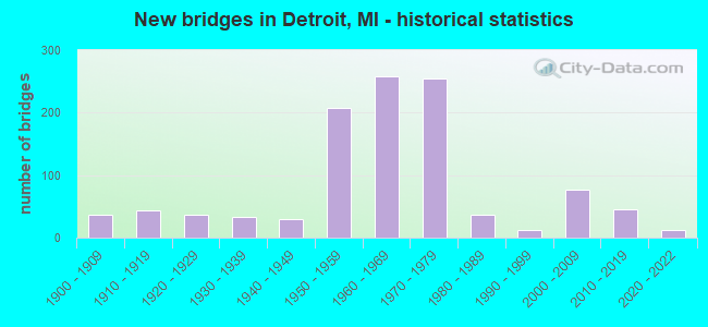
- New bridges - historical statistics
- 1Before 1900
- 371900-1909
- 431910-1919
- 371920-1929
- 331930-1939
- 291940-1949
- 2071950-1959
- 2591960-1969
- 2551970-1979
- 361980-1989
- 131990-1999
- 762000-2009
- 462010-2019
- 132020-2022
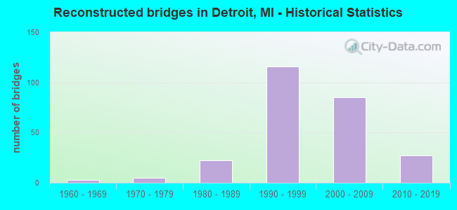
- Reconstructed bridges - Historical Statistics
- 31960-1969
- 51970-1979
- 221980-1989
- 1161990-1999
- 852000-2009
- 272010-2019
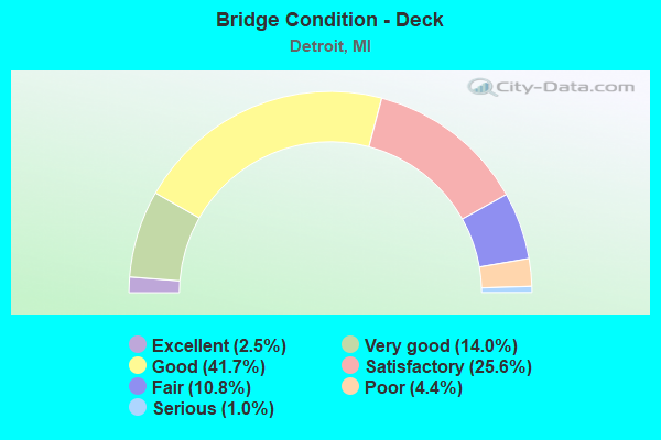
- Bridge Condition - Deck
- 2.5%Excellent
- 14.0%Very good
- 41.7%Good
- 25.6%Satisfactory
- 10.8%Fair
- 4.4%Poor
- 1.0%Serious
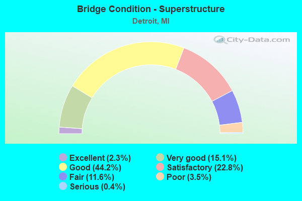
- Bridge Condition - Superstructure
- 2.3%Excellent
- 15.1%Very good
- 44.2%Good
- 22.8%Satisfactory
- 11.6%Fair
- 3.5%Poor
- 0.4%Serious
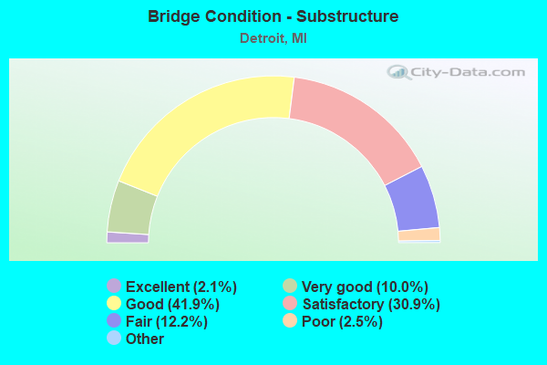
- Bridge Condition - Substructure
- 2.1%Excellent
- 10.0%Very good
- 41.9%Good
- 30.9%Satisfactory
- 12.2%Fair
- 2.5%Poor
- 0.4%Serious
- 0.2%Failed
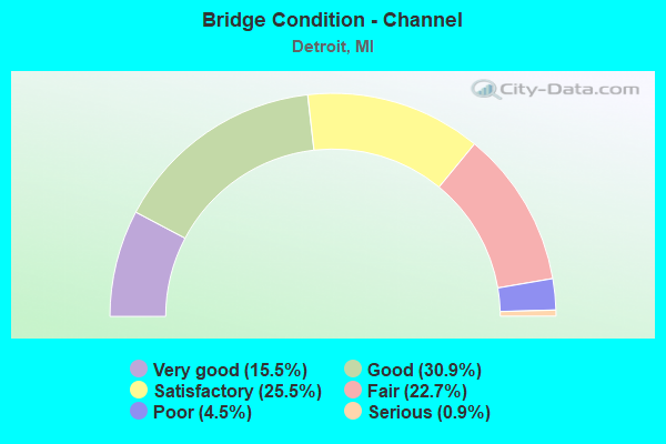
- Bridge Condition - Channel
- 15.5%Very good
- 30.9%Good
- 25.5%Satisfactory
- 22.7%Fair
- 4.5%Poor
- 0.9%Serious
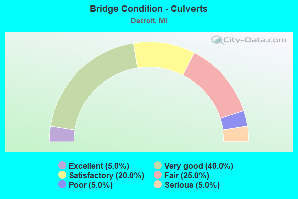
- Bridge Condition - Culverts
- 5.0%Excellent
- 40.0%Very good
- 20.0%Satisfactory
- 25.0%Fair
- 5.0%Poor
- 5.0%Serious
Find on map >> Show street view
Structure Number: 11438, Location: IN DETROIT (Lat: 42.398306, Lng: -83.109694), Route carried "under" structure: State highway 8, Year Built: 1956, Structure Length: 0. m, Average Daily Traffic: 79,030 (year 2007), Truck Traffic: 2%, Features Intersected: M-8 DAVISON, Facility Carried by Structure: M-10 WB
Minimum Vertical Clearance: 5.03m (16.50ft), Kilometerpoint: 4.407, Lanes on structure: 4, Lanes under structure: 7, Material/Design: Steel, Design/Construction: Stringer/Multi-beam, Length of Maximum Span: 21.7m (71.2ft)
Find on map >> Show street view
Structure Number: 11439, Location: IN DETROIT (Lat: 42.398683, Lng: -83.108642), Route carried "under" structure: State highway 8, Year Built: 1957, Structure Length: 0. m, Average Daily Traffic: 39,515 (year 2007), Truck Traffic: 2%, Features Intersected: M-8 EB DAVISON, Facility Carried by Structure: M-10 RAMP
Minimum Vertical Clearance: 4.62m (15.16ft), Kilometerpoint: 4.508, Lanes on structure: 1, Lanes under structure: 4, Material/Design: Steel, Design/Construction: Stringer/Multi-beam, Length of Maximum Span: 37.5m (123.0ft)
Find on map >> Show street view
Structure Number: 1144, Location: IN DETROIT (Lat: 42.398239, Lng: -83.110358), Route carried "under" structure: State highway 10, Year Built: 1956, Structure Length: 0. m, Average Daily Traffic: 78,042 (year 2007), Truck Traffic: 2%, Features Intersected: M-10 SB, Facility Carried by Structure: M-8 WB DAVISON
Minimum Vertical Clearance: 5.54m (18.18ft), Kilometerpoint: 10.060, Lanes on structure: 2, Lanes under structure: 4, Material/Design: Steel, Design/Construction: Stringer/Multi-beam, Length of Maximum Span: 22.8m (74.8ft)
Find on map >> Show street view
Structure Number: 11441, Location: IN DETROIT (Lat: 42.398850, Lng: -83.111458), Route carried "under" structure: State highway 10, Year Built: 1957, Structure Length: 0. m, Average Daily Traffic: 78,042 (year 2007), Truck Traffic: 2%, Features Intersected: M-10 SB, Facility Carried by Structure: NB TO WB DAVISON
Minimum Vertical Clearance: 5.64m (18.50ft), Kilometerpoint: 9.949, Lanes on structure: 1, Lanes under structure: 4, Material/Design: Steel, Design/Construction: Stringer/Multi-beam, Length of Maximum Span: 25.9m (85.0ft)
Find on map >> Show street view
Structure Number: 11442, Location: IN DETROIT (Lat: 42.401672, Lng: -83.115539), Route carried "under" structure: State highway 10, Year Built: 1955, Structure Length: 0. m, Average Daily Traffic: 156,084 (year 2007), Truck Traffic: 2%, Features Intersected: M-10, Facility Carried by Structure: OAKMAN BLVD
Minimum Vertical Clearance: 4.47m (14.67ft), Kilometerpoint: 9.484, Lanes on structure: 4, Lanes under structure: 7, Material/Design: Steel continuous, Design/Construction: Stringer/Multi-beam, Length of Maximum Span: 22.5m (73.8ft)
Find on map >> Show street view
Structure Number: 11443, Location: IN DETROIT (Lat: 42.403333, Lng: -83.118061), Route carried "under" structure: State highway 10, Year Built: 1957, Structure Length: 0. m, Average Daily Traffic: 156,084 (year 2007), Truck Traffic: 2%, Features Intersected: M-10, Facility Carried by Structure: ROSA PARKS BLVD
Minimum Vertical Clearance: 5.05m (16.57ft), Kilometerpoint: 9.219, Lanes on structure: 4, Lanes under structure: 7, Material/Design: Steel continuous, Design/Construction: Stringer/Multi-beam, Length of Maximum Span: 21.3m (69.9ft)
Find on map >> Show street view
Structure Number: 11444, Location: IN DETROIT (Lat: 42.405081, Lng: -83.127400), Route carried "under" structure: State highway 10, Year Built: 1955, Structure Length: 0. m, Average Daily Traffic: 156,084 (year 2007), Truck Traffic: 2%, Features Intersected: M-10 JOHN LODGE FRWY, Facility Carried by Structure: LINWOOD AVE
Minimum Vertical Clearance: 4.47m (14.67ft), Kilometerpoint: 8.406, Lanes on structure: 4, Lanes under structure: 6, Material/Design: Steel continuous, Design/Construction: Stringer/Multi-beam, Length of Maximum Span: 16.7m (54.8ft)
Find on map >> Show street view
Structure Number: 11445, Location: IN DETROIT (Lat: 42.405019, Lng: -83.135522), Route carried "under" structure: State highway 10, Year Built: 1955, Structure Length: 0. m, Average Daily Traffic: 155,986 (year 2007), Truck Traffic: 2%, Features Intersected: M-10 JOHN LODGE FRWY, Facility Carried by Structure: DEXTER-BELDEN AVE
Minimum Vertical Clearance: 4.34m (14.24ft), Kilometerpoint: 7.735, Lanes on structure: 4, Lanes under structure: 6, Material/Design: Steel continuous, Design/Construction: Stringer/Multi-beam, Length of Maximum Span: 17.7m (58.1ft)
Find on map >> Show street view
Structure Number: 11446, Location: IN DETROIT (Lat: 42.404808, Lng: -83.140339), Route carried "under" structure: State highway 10, Year Built: 1955, Structure Length: 0. m, Average Daily Traffic: 157,070 (year 2007), Truck Traffic: 2%, Features Intersected: M-10, Facility Carried by Structure: LIVERNOIS AVE
Minimum Vertical Clearance: 4.29m (14.07ft), Kilometerpoint: 7.350, Lanes on structure: 8, Lanes under structure: 6, Material/Design: Steel continuous, Design/Construction: Stringer/Multi-beam, Length of Maximum Span: 19.8m (65.0ft)
Find on map >> Show street view
Structure Number: 11447, Location: IN DETROIT (Lat: 42.404717, Lng: -83.150603), Route carried "under" structure: State highway 10, Year Built: 1955, Structure Length: 0. m, Average Daily Traffic: 157,070 (year 2007), Truck Traffic: 2%, Features Intersected: M-10, Facility Carried by Structure: GREENLAWN AVE
Minimum Vertical Clearance: 4.52m (14.83ft), Kilometerpoint: 6.497, Lanes on structure: 4, Lanes under structure: 6, Material/Design: Steel continuous, Design/Construction: Stringer/Multi-beam, Length of Maximum Span: 16.7m (54.8ft)
Find on map >> Show street view
Structure Number: 11448, Location: IN DETROIT (Lat: 42.405003, Lng: -83.159803), Route carried "under" structure: State highway 10, Year Built: 1955, Structure Length: 0. m, Average Daily Traffic: 157,070 (year 2007), Truck Traffic: 2%, Features Intersected: M-10, Facility Carried by Structure: WYOMING AVE
Minimum Vertical Clearance: 4.95m (16.24ft), Kilometerpoint: 5.731, Lanes on structure: 5, Lanes under structure: 5, Material/Design: Steel continuous, Design/Construction: Stringer/Multi-beam, Length of Maximum Span: 18.9m (62.0ft)
Find on map >> Show street view
Structure Number: 11449, Location: IN DETROIT (Lat: 42.409619, Lng: -83.164975), Route carried "under" structure: State highway 10, Year Built: 1963, Structure Length: 0. m, Average Daily Traffic: 150,070 (year 2007), Truck Traffic: 2%, Features Intersected: M-10, Facility Carried by Structure: PURITAN AVE
Minimum Vertical Clearance: 4.85m (15.91ft), Kilometerpoint: 5.058, Lanes on structure: 4, Lanes under structure: 6, Material/Design: Steel, Design/Construction: Stringer/Multi-beam, Length of Maximum Span: 20.4m (66.9ft)
Find on map >> Show street view
Structure Number: 1145, Location: IN DETROIT (Lat: 42.414167, Lng: -83.169981), Route carried "under" structure: State highway 10, Year Built: 1963, Structure Length: 0. m, Average Daily Traffic: 150,070 (year 2007), Truck Traffic: 2%, Features Intersected: M-10, Facility Carried by Structure: MYERS RD
Minimum Vertical Clearance: 4.57m (14.99ft), Kilometerpoint: 4.416, Lanes on structure: 4, Lanes under structure: 6, Material/Design: Steel, Design/Construction: Stringer/Multi-beam, Length of Maximum Span: 31.8m (104.3ft)
Find on map >> Show street view
Structure Number: 11451, Location: IN DETROIT (Lat: 42.413950, Lng: -83.169561), Route carried "under" structure: State highway 10, Year Built: 1963, Structure Length: 0. m, Average Daily Traffic: 150,070 (year 2007), Truck Traffic: 2%, Features Intersected: M-10, Facility Carried by Structure: MYERS RD TURNAROUN
Minimum Vertical Clearance: 5.03m (16.50ft), Kilometerpoint: 4.455, Lanes on structure: 1, Lanes under structure: 6, Material/Design: Steel, Design/Construction: Stringer/Multi-beam, Length of Maximum Span: 16.9m (55.4ft)
Find on map >> Show street view
Structure Number: 11452, Location: IN DETROIT (Lat: 42.416642, Lng: -83.172056), Route carried "under" structure: State highway 10, Year Built: 1964, Structure Length: 0. m, Average Daily Traffic: 124,630 (year 2007), Truck Traffic: 2%, Features Intersected: M-10, Facility Carried by Structure: MCNICHOLS RD
Minimum Vertical Clearance: 4.88m (16.01ft), Kilometerpoint: 4.083, Lanes on structure: 8, Lanes under structure: 6, Material/Design: Steel, Design/Construction: Stringer/Multi-beam, Length of Maximum Span: 20.5m (67.3ft)
Find on map >> Show street view
Structure Number: 11453, Location: IN DETROIT (Lat: 42.420908, Lng: -83.176089), Route carried "under" structure: State highway 10, Year Built: 1964, Structure Length: 0. m, Average Daily Traffic: 124,630 (year 2007), Truck Traffic: 2%, Features Intersected: M-10, Facility Carried by Structure: OUTER DRIVE EB
Minimum Vertical Clearance: 4.93m (16.17ft), Kilometerpoint: 3.513, Lanes on structure: 4, Lanes under structure: 6, Material/Design: Steel, Design/Construction: Stringer/Multi-beam, Length of Maximum Span: 16.8m (55.1ft)
Find on map >> Show street view
Structure Number: 11454, Location: IN DETROIT (Lat: 42.421075, Lng: -83.176244), Route carried "under" structure: State highway 10, Year Built: 1964, Structure Length: 0. m, Average Daily Traffic: 124,630 (year 2007), Truck Traffic: 2%, Features Intersected: M-10, Facility Carried by Structure: OUTER DRIVE WB
Minimum Vertical Clearance: 4.78m (15.68ft), Kilometerpoint: 3.491, Lanes on structure: 5, Lanes under structure: 6, Material/Design: Steel, Design/Construction: Stringer/Multi-beam, Length of Maximum Span: 16.8m (55.1ft)
Find on map >> Show street view
Structure Number: 11455, Location: IN DETROIT (Lat: 42.424836, Lng: -83.180189), Route carried "under" structure: State highway 10, Year Built: 1964, Structure Length: 0. m, Average Daily Traffic: 124,630 (year 2007), Truck Traffic: 2%, Features Intersected: M-10, Facility Carried by Structure: SCHAFFER
Minimum Vertical Clearance: 4.83m (15.85ft), Kilometerpoint: 2.963, Lanes on structure: 4, Lanes under structure: 6, Material/Design: Steel, Design/Construction: Stringer/Multi-beam, Length of Maximum Span: 27.1m (88.9ft)
Find on map >> Show street view
Structure Number: 11456, Location: IN DETROIT (Lat: 42.424689, Lng: -83.179786), Route carried "under" structure: State highway 10, Year Built: 1964, Structure Length: 0. m, Average Daily Traffic: 124,630 (year 2007), Truck Traffic: 3%, Features Intersected: M-10, Facility Carried by Structure: SCHAEFER SE TURN
Minimum Vertical Clearance: 5.11m (16.77ft), Kilometerpoint: 2.997, Lanes on structure: 1, Lanes under structure: 6, Material/Design: Steel, Design/Construction: Stringer/Multi-beam, Length of Maximum Span: 16.7m (54.8ft)
Find on map >> Show street view
Structure Number: 11457, Location: IN DETROIT (Lat: 42.425272, Lng: -83.180464), Route carried "under" structure: State highway 10, Year Built: 1964, Structure Length: 0. m, Average Daily Traffic: 124,630 (year 2007), Truck Traffic: 3%, Features Intersected: M-10, Facility Carried by Structure: SCHAEFER NW TURN
Minimum Vertical Clearance: 4.80m (15.75ft), Kilometerpoint: 2.910, Lanes on structure: 1, Lanes under structure: 6, Material/Design: Steel, Design/Construction: Stringer/Multi-beam, Length of Maximum Span: 16.7m (54.8ft)
Find on map >> Show street view
Structure Number: 11458, Location: IN DETROIT (Lat: 42.430833, Lng: -83.186942), Route carried "under" structure: State highway 10, Year Built: 1964, Structure Length: 0. m, Average Daily Traffic: 124,630 (year 2007), Truck Traffic: 2%, Features Intersected: M-10, Facility Carried by Structure: 7 MI RD
Minimum Vertical Clearance: 4.90m (16.08ft), Kilometerpoint: 2.084, Lanes on structure: 8, Lanes under structure: 6, Material/Design: Steel, Design/Construction: Stringer/Multi-beam, Length of Maximum Span: 20.7m (67.9ft)
Find on map >> Show street view
Structure Number: 11459, Location: IN DETROIT (Lat: 42.434208, Lng: -83.190347), Route carried "under" structure: State highway 10, Year Built: 1963, Structure Length: 0. m, Average Daily Traffic: 123,644 (year 2007), Truck Traffic: 2%, Features Intersected: M-10, Facility Carried by Structure: VASSAR DRIVE
Minimum Vertical Clearance: 4.90m (16.08ft), Kilometerpoint: 1.625, Lanes on structure: 4, Lanes under structure: 6, Material/Design: Steel, Design/Construction: Stringer/Multi-beam, Length of Maximum Span: 16.7m (54.8ft)
Find on map >> Show street view
Structure Number: 1146, Location: IN DETROIT (Lat: 42.437836, Lng: -83.194156), Route carried "under" structure: State highway 10, Year Built: 1963, Structure Length: 0. m, Average Daily Traffic: 123,644 (year 2007), Truck Traffic: 2%, Features Intersected: M-10, Facility Carried by Structure: PEMBROKE AVE
Minimum Vertical Clearance: 4.83m (15.85ft), Kilometerpoint: 1.106, Lanes on structure: 4, Lanes under structure: 6, Material/Design: Steel, Design/Construction: Stringer/Multi-beam, Length of Maximum Span: 21.6m (70.9ft)
Find on map >> Show street view
Structure Number: 11461, Location: IN DETROIT (Lat: 42.442344, Lng: -83.200381), Route carried "under" structure: State highway 10, Year Built: 1964, Structure Length: 0. m, Average Daily Traffic: 123,644 (year 2007), Truck Traffic: 2%, Features Intersected: M-10, Facility Carried by Structure: GREENFIELD RD
Minimum Vertical Clearance: 4.67m (15.32ft), Kilometerpoint: 0.401, Lanes on structure: 4, Lanes under structure: 6, Material/Design: Steel, Design/Construction: Stringer/Multi-beam, Length of Maximum Span: 24.7m (81.0ft)
Find on map >> Show street view
Structure Number: 11462, Location: IN DETROIT (Lat: 42.442219, Lng: -83.199961), Route carried "under" structure: State highway 10, Year Built: 1964, Structure Length: 0. m, Average Daily Traffic: 123,644 (year 2007), Truck Traffic: 2%, Features Intersected: M-10, Facility Carried by Structure: GREENFIELD RD TURN
Minimum Vertical Clearance: 5.13m (16.83ft), Kilometerpoint: 0.435, Lanes on structure: 1, Lanes under structure: 6, Material/Design: Steel, Design/Construction: Stringer/Multi-beam, Length of Maximum Span: 17.0m (55.8ft)
Find on map >> Show street view
Structure Number: 11463, Location: IN DETROIT @ FORRER AVE (Lat: 42.443939, Lng: -83.202281), Route carried "under" structure: State highway 10, Year Built: 1963, Structure Length: 0. m, Average Daily Traffic: 70,270 (year 2007), Truck Traffic: 4%, Features Intersected: M-10
Minimum Vertical Clearance: 5.64m (18.50ft), Kilometerpoint: 0.151, Lanes on structure: 2, Lanes under structure: 6, Material/Design: Steel, Design/Construction: Stringer/Multi-beam, Length of Maximum Span: 23.7m (77.8ft)
Find on map >> Show street view
Structure Number: 11464, Location: N LTS OF DETROIT (Lat: 42.445078, Lng: -83.203417), Route carried "under" structure: Ramp State highway 10, Year Built: 1965, Structure Length: 0. m, Average Daily Traffic: 9,500 (year 1978), Features Intersected: M-10 RAMP
Minimum Vertical Clearance: 5.11m (16.77ft), Kilometerpoint: 0.143, Lanes on structure: 1, Lanes under structure: 1, Material/Design: Steel, Design/Construction: Stringer/Multi-beam, Length of Maximum Span: 17.3m (56.8ft)
Find on map >> Show street view
Structure Number: 11465, Location: N LTS OF DETROIT (Lat: 42.444917, Lng: -83.203264), Route carried "under" structure: State highway 10, Year Built: 1965, Structure Length: 0. m, Average Daily Traffic: 70,270 (year 2007), Truck Traffic: 4%, Features Intersected: M-10
Minimum Vertical Clearance: 5.18m (16.99ft), Kilometerpoint: 0.000, Lanes on structure: 2, Lanes under structure: 7, Material/Design: Steel, Design/Construction: Stringer/Multi-beam, Length of Maximum Span: 21.9m (71.9ft)
Find on map >> Show street view
Structure Number: 11466, Location: N LTS OF DETROIT (Lat: 42.444578, Lng: -83.202881), Route carried "under" structure: State highway 10, Year Built: 1965, Structure Length: 0. m, Average Daily Traffic: 70,270 (year 2007), Truck Traffic: 4%, Features Intersected: M-10
Minimum Vertical Clearance: 5.33m (17.49ft), Kilometerpoint: 0.052, Lanes on structure: 2, Lanes under structure: 7, Material/Design: Steel, Design/Construction: Stringer/Multi-beam, Length of Maximum Span: 23.1m (75.8ft)
Find on map >> Show street view
Structure Number: 11467, Location: IN DETROIT (Lat: 42.444789, Lng: -83.200514), Route carried "under" structure: State highway 10, Year Built: 1965, Structure Length: 0. m, Average Daily Traffic: 70,270 (year 2007), Truck Traffic: 4%, Features Intersected: M-10 & RAMPS
Minimum Vertical Clearance: 5.16m (16.93ft), Kilometerpoint: 19.794, Lanes on structure: 6, Lanes under structure: 21, Material/Design: Steel continuous, Design/Construction: Stringer/Multi-beam, Length of Maximum Span: 64.7m (212.3ft)
Find on map >> Show street view
Structure Number: 11468, Location: IN DETROIT (Lat: 42.442989, Lng: -83.201017), Route carried "under" structure: State highway 10, Year Built: 1964, Structure Length: 0. m, Average Daily Traffic: 70,270 (year 2007), Truck Traffic: 4%, Features Intersected: M-10, Facility Carried by Structure: GREENFIELD RD LF T
Minimum Vertical Clearance: 4.52m (14.83ft), Kilometerpoint: 0.314, Lanes on structure: 1, Lanes under structure: 7, Material/Design: Steel, Design/Construction: Stringer/Multi-beam, Length of Maximum Span: 16.9m (55.4ft)
Find on map >> Show street view
Structure Number: 11469, Location: IN DETROIT (Lat: 42.404928, Lng: -83.141833), Route carried "under" structure: State highway 10, Year Built: 1987, Structure Length: 0. m, Average Daily Traffic: 157,070 (year 2007), Truck Traffic: 2%, Features Intersected: M-10, Facility Carried by Structure: LIVERNOIS AV UTURN
Minimum Vertical Clearance: 4.62m (15.16ft), Kilometerpoint: 7.218, Lanes on structure: 2, Lanes under structure: 6, Material/Design: Prestressed concrete, Design/Construction: Box Beam or Girders - Multiple, Length of Maximum Span: 17.3m (56.8ft)
Find on map >> Show street view
Structure Number: 1147, Location: IN DETROIT (Lat: 42.363986, Lng: -83.079372), Route carried "under" structure: State highway 10, Year Built: 1949, Structure Length: 0. m, Average Daily Traffic: 126,308 (year 2007), Truck Traffic: 2%, Features Intersected: M-10, Facility Carried by Structure: CONRAIL
Minimum Vertical Clearance: 4.57m (14.99ft), Kilometerpoint: 14.758, Lanes under structure: 6, Material/Design: Steel, Design/Construction: Stringer/Multi-beam, Length of Maximum Span: 21.9m (71.9ft)
Find on map >> Show street view
Structure Number: 11471, Location: IN DETROIT (Lat: 42.364214, Lng: -83.079531), Route carried "under" structure: State highway 10, Year Built: 1949, Structure Length: 0. m, Average Daily Traffic: 126,308 (year 2007), Truck Traffic: 2%, Features Intersected: M-10, Facility Carried by Structure: GTW RR
Minimum Vertical Clearance: 4.85m (15.91ft), Kilometerpoint: 14.729, Lanes under structure: 6, Material/Design: Steel, Design/Construction: Stringer/Multi-beam, Length of Maximum Span: 21.6m (70.9ft)
Find on map >> Show street view
Structure Number: 11472, Location: IN DETROIT (Lat: 42.402764, Lng: -83.117197), Route carried "under" structure: State highway 10, Year Built: 1957, Structure Length: 0. m, Average Daily Traffic: 156,084 (year 2007), Truck Traffic: 2%, Features Intersected: M-10, Facility Carried by Structure: CONRAIL
Minimum Vertical Clearance: 4.44m (14.57ft), Kilometerpoint: 9.304, Lanes under structure: 7, Material/Design: Steel, Design/Construction: Stringer/Multi-beam, Length of Maximum Span: 24.7m (81.0ft)
Find on map >> Show street view
Structure Number: 11475, Location: IN DETROIT (Lat: 42.333658, Lng: -83.052133), Route carried "under" structure: City street , Year Built: 1989, Structure Length: 0. m, Average Daily Traffic: 10,280 (year 2003), Truck Traffic: 2%, Features Intersected: GRAND RIVER AVE, Facility Carried by Structure: PED @ BOOK BLDG
Minimum Vertical Clearance: 5.03m (16.50ft), Kilometerpoint: 19.989, Lanes under structure: 2, Material/Design: Steel, Design/Construction: Stringer/Multi-beam, Length of Maximum Span: 22.5m (73.8ft)
Find on map >> Show street view
Structure Number: 11476, Location: NEAR GREENFIELD (Lat: 42.392419, Lng: -83.197769), Route carried "under" structure: State highway 5, Year Built: 1986, Structure Length: 0. m, Average Daily Traffic: 16,025 (year 2007), Truck Traffic: 4%, Features Intersected: M-5 GRAND RIVER, Facility Carried by Structure: PED @ JORDAN COLL
Minimum Vertical Clearance: 5.11m (16.77ft), Kilometerpoint: 6.331, Lanes under structure: 2, Material/Design: Steel, Design/Construction: Stringer/Multi-beam, Length of Maximum Span: 53.9m (176.8ft)
Find on map >> Show street view
Structure Number: 11477, Location: IN DETROIT (E BRIDGE) (Lat: 42.349044, Lng: -83.090167), Route carried "under" structure: Business State highway 5, Year Built: 1936, Structure Length: 0. m, Average Daily Traffic: 8,109 (year 2007), Truck Traffic: 6%, Features Intersected: M-5, GRAND RIVER AVE, Facility Carried by Structure: CONRAIL
Minimum Vertical Clearance: 4.34m (14.24ft), Kilometerpoint: 16.417, Lanes under structure: 7, Material/Design: Steel, Design/Construction: Girder and Floorbeam System, Length of Maximum Span: 27.1m (88.9ft)
Find on map >> Show street view
Structure Number: 11478, Location: IN DETROIT (W BRIDGE) (Lat: 42.349181, Lng: -83.090503), Route carried "under" structure: Business State highway 5, Year Built: 1936, Structure Length: 0. m, Average Daily Traffic: 8,109 (year 2007), Truck Traffic: 6%, Features Intersected: M-5, GRAND RIVER AVE, Facility Carried by Structure: GTW RR
Minimum Vertical Clearance: 4.32m (14.17ft), Kilometerpoint: 16.387, Lanes under structure: 7, Material/Design: Steel, Design/Construction: Girder and Floorbeam System, Length of Maximum Span: 27.1m (88.9ft)
Find on map >> Show street view
Structure Number: 11482, Location: IN DETROIT (Lat: 42.385111, Lng: -83.250967), Route carried "under" structure: Interstate 96, Year Built: 1971, Structure Length: 0. m, Average Daily Traffic: 164,804 (year 2007), Truck Traffic: 5%, Features Intersected: I-96, Facility Carried by Structure: BENTLER PED X-OVER
Minimum Vertical Clearance: 5.41m (17.75ft), Kilometerpoint: 16.273, Lanes under structure: 12, Material/Design: Steel, Design/Construction: Stringer/Multi-beam, Length of Maximum Span: 31.6m (103.7ft)
Find on map >> Show street view
Structure Number: 11483, Location: IN DETROIT (Lat: 42.384622, Lng: -83.241486), Route carried "under" structure: Interstate 96, Year Built: 1971, Structure Length: 0. m, Average Daily Traffic: 151,444 (year 2007), Truck Traffic: 5%, Features Intersected: I-96, Facility Carried by Structure: STOUT AVE PED X-OV
Minimum Vertical Clearance: 5.26m (17.26ft), Kilometerpoint: 17.058, Lanes under structure: 13, Material/Design: Steel, Design/Construction: Stringer/Multi-beam, Length of Maximum Span: 28.3m (92.8ft)
Find on map >> Show street view
Structure Number: 11485, Location: IN DETROIT (Lat: 42.377747, Lng: -83.236500), Route carried "under" structure: Interstate 96, Year Built: 1971, Structure Length: 0. m, Average Daily Traffic: 160,973 (year 2014), Truck Traffic: 5%, Features Intersected: I-96 & CSX RR, Facility Carried by Structure: EVERGREEN RD
Minimum Vertical Clearance: 7.01m (23.00ft), Kilometerpoint: 17.679, Lanes on structure: 7, Lanes under structure: 12, Material/Design: Steel, Design/Construction: Stringer/Multi-beam, Length of Maximum Span: 27.4m (89.9ft)
Find on map >> Show street view
Structure Number: 11506, Location: IN DETROIT (Lat: 42.385256, Lng: -83.275764), Route carried "under" structure: Interstate 96, Year Built: 1970, Structure Length: 0. m, Average Daily Traffic: 131,100 (year 2012), Truck Traffic: 4%, Features Intersected: I-96, Facility Carried by Structure: NB SERV RD
Minimum Vertical Clearance: 4.62m (15.16ft), Kilometerpoint: 14.219, Lanes on structure: 4, Lanes under structure: 8, Material/Design: Steel, Design/Construction: Stringer/Multi-beam, Length of Maximum Span: 24.9m (81.7ft)
Find on map >> Show street view
Structure Number: 11507, Location: IN DETROIT (Lat: 42.385239, Lng: -83.276425), Route carried "under" structure: Interstate 96, Year Built: 1970, Structure Length: 0. m, Average Daily Traffic: 139,400 (year 2012), Truck Traffic: 5%, Features Intersected: I-96, Facility Carried by Structure: SB SERV RD
Minimum Vertical Clearance: 4.52m (14.83ft), Kilometerpoint: 14.176, Lanes on structure: 4, Lanes under structure: 8, Material/Design: Steel, Design/Construction: Stringer/Multi-beam, Length of Maximum Span: 24.9m (81.7ft)
Find on map >> Show street view
Structure Number: 11508, Location: IN DETROIT (Lat: 42.385428, Lng: -83.271111), Route carried "under" structure: Interstate 96, Year Built: 1970, Structure Length: 0. m, Average Daily Traffic: 164,804 (year 2007), Truck Traffic: 5%, Features Intersected: I-96, Facility Carried by Structure: VIRGIL ST
Minimum Vertical Clearance: 4.67m (15.32ft), Kilometerpoint: 14.613, Lanes on structure: 2, Lanes under structure: 11, Material/Design: Steel, Design/Construction: Stringer/Multi-beam, Length of Maximum Span: 42.6m (139.8ft)
Find on map >> Show street view
Structure Number: 11509, Location: IN DETROIT (Lat: 42.385433, Lng: -83.256028), Route carried "under" structure: Interstate 96, Year Built: 1970, Structure Length: 0. m, Average Daily Traffic: 164,804 (year 2007), Truck Traffic: 5%, Features Intersected: I-96, Facility Carried by Structure: OUTER DRIVE
Minimum Vertical Clearance: 4.60m (15.09ft), Kilometerpoint: 15.825, Lanes on structure: 10, Lanes under structure: 10, Material/Design: Steel, Design/Construction: Stringer/Multi-beam, Length of Maximum Span: 35.0m (114.8ft)
Find on map >> Show street view
Structure Number: 1151, Location: IN DETROIT (Lat: 42.385272, Lng: -83.246578), Route carried "under" structure: Interstate 96, Year Built: 1970, Structure Length: 0. m, Average Daily Traffic: 151,444 (year 2007), Truck Traffic: 5%, Features Intersected: I-96, Facility Carried by Structure: BURT RD
Minimum Vertical Clearance: 4.98m (16.34ft), Kilometerpoint: 16.635, Lanes on structure: 4, Lanes under structure: 12, Material/Design: Steel, Design/Construction: Stringer/Multi-beam, Length of Maximum Span: 23.1m (75.8ft)
Find on map >> Show street view
Structure Number: 11511, Location: IN DETROIT (Lat: 42.385683, Lng: -83.244597), Route carried "under" structure: Interstate 96, Year Built: 1970, Structure Length: 0. m, Average Daily Traffic: 151,444 (year 2007), Truck Traffic: 5%, Features Intersected: I-96, Facility Carried by Structure: SCHOOLCRAFT X-OVER
Minimum Vertical Clearance: 4.88m (16.01ft), Kilometerpoint: 16.764, Lanes on structure: 2, Lanes under structure: 12, Material/Design: Steel, Design/Construction: Stringer/Multi-beam, Length of Maximum Span: 37.5m (123.0ft)
Find on map >> Show street view
Structure Number: 11512, Location: IN DETROIT (Lat: 42.382300, Lng: -83.238664), Route carried "under" structure: Interstate 96, Year Built: 1970, Structure Length: 0. m, Average Daily Traffic: 151,444 (year 2007), Truck Traffic: 5%, Features Intersected: I-96, Facility Carried by Structure: GLENDALE AVE
Minimum Vertical Clearance: 5.51m (18.08ft), Kilometerpoint: 17.398, Lanes on structure: 2, Lanes under structure: 10, Material/Design: Steel, Design/Construction: Stringer/Multi-beam, Length of Maximum Span: 19.8m (65.0ft)
Find on map >> Show street view
Structure Number: 11513, Location: IN DETROIT (Lat: 42.378347, Lng: -83.231411), Route carried "under" structure: Interstate 96, Year Built: 1973, Structure Length: 0. m, Average Daily Traffic: 157,726 (year 2007), Truck Traffic: 5%, Features Intersected: I-96, Facility Carried by Structure: INDUSTRIAL AVE
Minimum Vertical Clearance: 6.10m (20.01ft), Kilometerpoint: 17.765, Lanes on structure: 2, Lanes under structure: 12, Material/Design: Steel, Design/Construction: Stringer/Multi-beam, Length of Maximum Span: 19.5m (64.0ft)
Find on map >> Show street view
Structure Number: 11531, Location: IN DETROIT E OF EVERGREEN (Lat: 42.379003, Lng: -83.233803), Route carried "under" structure: Interstate 96, Year Built: 1974, Structure Length: 0. m, Average Daily Traffic: 157,726 (year 2007), Truck Traffic: 5%, Features Intersected: I-96, Facility Carried by Structure: CSX RR
Minimum Vertical Clearance: 4.93m (16.17ft), Kilometerpoint: 17.872, Lanes under structure: 12, Material/Design: Steel, Design/Construction: Stringer/Multi-beam, Length of Maximum Span: 31.7m (104.0ft)
Find on map >> Show street view
Structure Number: 11532, Location: IN DETROIT E OF EVERGREEN (Lat: 42.378272, Lng: -83.230581), Route carried "under" structure: Interstate 96, Year Built: 1972, Structure Length: 0. m, Average Daily Traffic: 157,726 (year 2007), Truck Traffic: 5%, Features Intersected: I-96, Facility Carried by Structure: CSX RR
Minimum Vertical Clearance: 4.88m (16.01ft), Kilometerpoint: 18.222, Lanes under structure: 12, Material/Design: Steel, Design/Construction: Girder and Floorbeam System, Length of Maximum Span: 28.9m (94.8ft)
Find on map >> Show street view
Structure Number: 11533, Location: IN DETROIT (Lat: 42.384328, Lng: -83.171503), Route carried "under" structure: Interstate 96, Year Built: 1971, Structure Length: 0. m, Average Daily Traffic: 163,508 (year 2007), Truck Traffic: 4%, Features Intersected: I-96, Facility Carried by Structure: SORENTO PED X-OVER
Minimum Vertical Clearance: 6.02m (19.75ft), Kilometerpoint: 23.228, Lanes under structure: 17, Material/Design: Steel, Design/Construction: Stringer/Multi-beam, Length of Maximum Span: 38.1m (125.0ft)
Find on map >> Show street view
Structure Number: 11534, Location: IN DETROIT (Lat: 42.385633, Lng: -83.164739), Route carried "under" structure: Interstate 96, Year Built: 1971, Structure Length: 0. m, Average Daily Traffic: 163,508 (year 2007), Truck Traffic: 4%, Features Intersected: I-96, Facility Carried by Structure: MENDOTA PED X-OVER
Minimum Vertical Clearance: 6.05m (19.85ft), Kilometerpoint: 23.798, Lanes under structure: 14, Material/Design: Steel continuous, Length of Maximum Span: 37.8m (124.0ft)
Find on map >> Show street view
Structure Number: 11535, Location: IN DETROIT (Lat: 42.384508, Lng: -83.154572), Route carried "under" structure: Interstate 96, Year Built: 1971, Structure Length: 0. m, Average Daily Traffic: 94,800 (year 2016), Truck Traffic: 5%, Features Intersected: I-96, Facility Carried by Structure: CHERRYLAWN PED X-O
Minimum Vertical Clearance: 7.11m (23.33ft), Kilometerpoint: 24.637, Lanes under structure: 18, Material/Design: Steel, Design/Construction: Stringer/Multi-beam, Length of Maximum Span: 50.4m (165.4ft)
Find on map >> Show street view
Structure Number: 11537, Location: IN DETROIT (Lat: 42.360092, Lng: -83.119628), Route carried "under" structure: Interstate 96, Year Built: 1972, Structure Length: 0. m, Average Daily Traffic: 114,356 (year 2007), Truck Traffic: 5%, Features Intersected: I-96, Facility Carried by Structure: IVANHOE AVE WALKOV
Minimum Vertical Clearance: 5.00m (16.40ft), Kilometerpoint: 3.595, Lanes under structure: 8, Material/Design: Steel continuous, Design/Construction: Girder and Floorbeam System, Length of Maximum Span: 27.7m (90.9ft)
Find on map >> Show street view
Structure Number: 11538, Location: IN DETROIT (Lat: 42.354397, Lng: -83.106408), Route carried "under" structure: Interstate 96, Year Built: 1972, Structure Length: 0. m, Average Daily Traffic: 116,948 (year 2007), Truck Traffic: 8%, Features Intersected: I-96, Facility Carried by Structure: ROOSEVELT WALKOVER
Minimum Vertical Clearance: 5.41m (17.75ft), Kilometerpoint: 4.857, Lanes under structure: 10, Material/Design: Steel continuous, Design/Construction: Girder and Floorbeam System, Length of Maximum Span: 30.4m (99.7ft)
Find on map >> Show street view
Structure Number: 11539, Location: IN DETROIT (Lat: 42.378842, Lng: -83.203831), Route carried "under" structure: Interstate 96, Year Built: 1973, Structure Length: 0. m, Average Daily Traffic: 157,726 (year 2007), Truck Traffic: 4%, Features Intersected: I-96 & CSX RR, Facility Carried by Structure: MANSFIELD PED X-OV
Minimum Vertical Clearance: 6.63m (21.75ft), Kilometerpoint: 20.464, Lanes under structure: 14, Material/Design: Steel, Design/Construction: Stringer/Multi-beam, Length of Maximum Span: 38.4m (126.0ft)
Find on map >> Show street view
Structure Number: 1154, Location: IN DETROIT (Lat: 42.379422, Lng: -83.217975), Route carried "under" structure: City street , Year Built: 1975, Structure Length: 0. m, Average Daily Traffic: 121,000 (year 1995), Truck Traffic: 6%, Features Intersected: CSX RR & FULLERTON AVE, Facility Carried by Structure: SB TO WB TURN RDWY
Minimum Vertical Clearance: 6.09m (19.98ft), Kilometerpoint: 1.748, Lanes on structure: 1, Lanes under structure: 2, Material/Design: Steel continuous, Design/Construction: Stringer/Multi-beam, Length of Maximum Span: 32.3m (106.0ft)
Find on map >> Show street view
Structure Number: 11541, Location: IN DETROIT (Lat: 42.378403, Lng: -83.216306), Route carried "under" structure: Interstate 96, Year Built: 1973, Structure Length: 0. m, Average Daily Traffic: 144,994 (year 2007), Truck Traffic: 3%, Features Intersected: I-96 & CSX RR, Facility Carried by Structure: TURN RDWY 3RD LEVL
Minimum Vertical Clearance: 5.56m (18.24ft), Kilometerpoint: 17.530, Lanes on structure: 2, Lanes under structure: 14, Material/Design: Steel continuous, Design/Construction: Stringer/Multi-beam, Length of Maximum Span: 36.2m (118.8ft)
Find on map >> Show street view
Structure Number: 11542, Location: IN DETROIT (Lat: 42.379461, Lng: -83.216750), Route carried "under" structure: ServiceInterstate 96, Year Built: 1973, Structure Length: 0. m, Average Daily Traffic: 6,500 (year 1995), Features Intersected: CSX RR & 3RD LEVL TRN RD, Facility Carried by Structure: TURN RDWY 4TH LEVL
Minimum Vertical Clearance: 4.65m (15.26ft), Kilometerpoint: 19.358, Lanes on structure: 1, Lanes under structure: 4, Material/Design: Steel continuous, Design/Construction: Stringer/Multi-beam, Length of Maximum Span: 31.7m (104.0ft)
Find on map >> Show street view
Structure Number: 11543, Location: IN DETROIT (Lat: 42.379467, Lng: -83.216372), Route carried "under" structure: City street , Year Built: 1973, Structure Length: 0. m, Average Daily Traffic: 143,000 (year 1995), Truck Traffic: 5%, Features Intersected: CSX RAILROAD-FULLERTON, Facility Carried by Structure: WB TO NB TURN RDWY
Minimum Vertical Clearance: 12.50m (41.01ft), Kilometerpoint: 0.103, Lanes on structure: 1, Lanes under structure: 4, Material/Design: Steel continuous, Design/Construction: Stringer/Multi-beam, Length of Maximum Span: 38.4m (126.0ft)
Find on map >> Show street view
Structure Number: 11544, Location: IN DETROIT (Lat: 42.378894, Lng: -83.198028), Route carried "under" structure: Interstate 96, Year Built: 1972, Structure Length: 0. m, Average Daily Traffic: 162,810 (year 2007), Truck Traffic: 4%, Features Intersected: I-96 & CSX RR, Facility Carried by Structure: GREENFIELD RD
Minimum Vertical Clearance: 5.97m (19.59ft), Kilometerpoint: 20.942, Lanes on structure: 7, Lanes under structure: 16, Material/Design: Steel, Design/Construction: Stringer/Multi-beam, Length of Maximum Span: 21.6m (70.9ft)
Find on map >> Show street view
Structure Number: 11547, Location: IN DETROIT (Lat: 42.377558, Lng: -83.217375), Route carried "under" structure: ServiceInterstate 96, Year Built: 1972, Structure Length: 0. m, Average Daily Traffic: 401 (year 2010), Truck Traffic: 1%, Features Intersected: WB&U-TURN SERVICE ROADS, Facility Carried by Structure: TURN RDWY EB TO SB
Minimum Vertical Clearance: 6.12m (20.08ft), Kilometerpoint: 0.275, Lanes on structure: 1, Lanes under structure: 1, Material/Design: Steel continuous, Design/Construction: Stringer/Multi-beam, Length of Maximum Span: 25.6m (84.0ft)
Find on map >> Show street view
Structure Number: 11547, Location: IN DETROIT (Lat: 42.377558, Lng: -83.217375), Route carried "under" structure: ServiceInterstate 96, Year Built: 1972, Structure Length: 0. m, Average Daily Traffic: 7,890 (year 2010), Truck Traffic: 5%, Features Intersected: WB&U-TURN SERVICE ROADS, Facility Carried by Structure: TURN RDWY EB TO SB
Minimum Vertical Clearance: 6.12m (20.08ft), Kilometerpoint: 0.048, Lanes on structure: 1, Lanes under structure: 2, Material/Design: Steel continuous, Design/Construction: Stringer/Multi-beam, Length of Maximum Span: 25.6m (84.0ft)
Find on map >> Show street view
Structure Number: 11547, Location: IN DETROIT (Lat: 42.377558, Lng: -83.217375), Route carried "under" structure: ServiceState highway 39, Year Built: 1972, Structure Length: 0. m, Average Daily Traffic: 7,890 (year 2010), Truck Traffic: 5%, Features Intersected: WB&U-TURN SERVICE ROADS, Facility Carried by Structure: TURN RDWY EB TO SB
Minimum Vertical Clearance: 30+ m (98+ ft), Kilometerpoint: 1.368, Lanes on structure: 1, Lanes under structure: 1, Material/Design: Steel continuous, Design/Construction: Stringer/Multi-beam, Length of Maximum Span: 25.6m (84.0ft)
Find on map >> Show street view
Structure Number: 11548, Location: IN DETROIT (Lat: 42.379058, Lng: -83.216450), Route carried "under" structure: ServiceInterstate 96, Year Built: 1972, Structure Length: 0. m, Average Daily Traffic: 14,000 (year 1977), Truck Traffic: 5%, Features Intersected: 3RD LEVEL TURN RDWY, Facility Carried by Structure: WB TO SB TURN RDWY
Minimum Vertical Clearance: 4.60m (15.09ft), Kilometerpoint: 18.973, Lanes on structure: 2, Lanes under structure: 3, Material/Design: Steel continuous, Design/Construction: Stringer/Multi-beam, Length of Maximum Span: 32.0m (105.0ft)
Find on map >> Show street view
Structure Number: 11549, Location: IN DETROIT (Lat: 42.378247, Lng: -83.216733), Route carried "under" structure: Interstate 96, Year Built: 1972, Structure Length: 0. m, Average Daily Traffic: 157,726 (year 2007), Truck Traffic: 5%, Features Intersected: I-96 ROADWAYS, Facility Carried by Structure: TURN RDWY 3RD LEVL
Minimum Vertical Clearance: 5.44m (17.85ft), Kilometerpoint: 19.377, Lanes on structure: 2, Lanes under structure: 14, Material/Design: Steel continuous, Design/Construction: Stringer/Multi-beam, Length of Maximum Span: 33.5m (109.9ft)
Find on map >> Show street view
Structure Number: 1155, Location: IN DETROIT (Lat: 42.378233, Lng: -83.216564), Route carried "under" structure: State highway 39, Year Built: 1970, Structure Length: 0. m, Average Daily Traffic: 144,994 (year 2007), Truck Traffic: 3%, Features Intersected: M-39(SOUTHFIELD EXPR), Facility Carried by Structure: U-TRN SERV RD
Minimum Vertical Clearance: 4.65m (15.26ft), Kilometerpoint: 17.473, Lanes on structure: 2, Lanes under structure: 8, Material/Design: Steel, Design/Construction: Stringer/Multi-beam, Length of Maximum Span: 24.7m (81.0ft)
Find on map >> Show street view
Structure Number: 11551, Location: IN DETROIT (Lat: 42.378406, Lng: -83.216631), Route carried "under" structure: State highway 39, Year Built: 1970, Structure Length: 0. m, Average Daily Traffic: 144,994 (year 2007), Truck Traffic: 3%, Features Intersected: M-39 SOUTHFIELD FRWY, Facility Carried by Structure: I-96 EB COLLECTOR
Minimum Vertical Clearance: 4.83m (15.85ft), Kilometerpoint: 17.491, Lanes on structure: 3, Lanes under structure: 8, Material/Design: Steel, Design/Construction: Stringer/Multi-beam, Length of Maximum Span: 23.4m (76.8ft)
Find on map >> Show street view
Structure Number: 11552, Location: IN DETROIT (Lat: 42.378639, Lng: -83.216697), Route carried "under" structure: State highway 39, Year Built: 1970, Structure Length: 0. m, Average Daily Traffic: 144,994 (year 2007), Truck Traffic: 3%, Features Intersected: M-39 (SOUTHFIELD EXP), Facility Carried by Structure: I-96 EB MAIN RDWY
Minimum Vertical Clearance: 5.46m (17.91ft), Kilometerpoint: 17.517, Lanes on structure: 3, Lanes under structure: 8, Material/Design: Steel, Design/Construction: Stringer/Multi-beam, Length of Maximum Span: 21.3m (69.9ft)
Find on map >> Show street view
Structure Number: 11553, Location: IN DETROIT (Lat: 42.379050, Lng: -83.216772), Route carried "under" structure: State highway 39, Year Built: 1970, Structure Length: 0. m, Average Daily Traffic: 142,894 (year 2007), Truck Traffic: 3%, Features Intersected: M-39 (SOUTHFIELD EXPR), Facility Carried by Structure: I-96 WB COLLECTOR
Minimum Vertical Clearance: 6.83m (22.41ft), Kilometerpoint: 17.562, Lanes on structure: 3, Lanes under structure: 8, Material/Design: Steel, Design/Construction: Stringer/Multi-beam, Length of Maximum Span: 17.9m (58.7ft)
Find on map >> Show street view
Structure Number: 11554, Location: IN DETROIT (Lat: 42.377811, Lng: -83.216119), Route carried "under" structure: Ramp State highway 39, Year Built: 1970, Structure Length: 0. m, Average Daily Traffic: 12,000 (year 1977), Features Intersected: M-39 RAMP & E SERVICE RD, Facility Carried by Structure: I-96 RAMP NB TO EB
Minimum Vertical Clearance: 5.49m (18.01ft), Kilometerpoint: 0.071, Lanes on structure: 2, Lanes under structure: 3, Material/Design: Steel continuous, Design/Construction: Stringer/Multi-beam, Length of Maximum Span: 23.1m (75.8ft)
Find on map >> Show street view
Structure Number: 11555, Location: IN DETROIT (Lat: 42.378803, Lng: -83.216728), Route carried "under" structure: State highway 39, Year Built: 1970, Structure Length: 0. m, Average Daily Traffic: 157,726 (year 2007), Truck Traffic: 3%, Features Intersected: M-39 (SOUTHFIELD EXPR), Facility Carried by Structure: I-96 WB MAIN RDWY
Minimum Vertical Clearance: 6.02m (19.75ft), Kilometerpoint: 17.534, Lanes on structure: 3, Lanes under structure: 8, Material/Design: Steel, Design/Construction: Stringer/Multi-beam, Length of Maximum Span: 20.1m (65.9ft)
Find on map >> Show street view
Structure Number: 11557, Location: IN DETROIT (Lat: 42.378314, Lng: -83.211378), Route carried "under" structure: ServiceInterstate 96, Year Built: 1973, Structure Length: 0. m, Average Daily Traffic: 8,500 (year 1995), Features Intersected: E B SERVICE RD
Minimum Vertical Clearance: 4.78m (15.68ft), Kilometerpoint: 3.476, Lanes on structure: 1, Lanes under structure: 2, Material/Design: Steel, Design/Construction: Stringer/Multi-beam, Length of Maximum Span: 44.5m (146.0ft)
Find on map >> Show street view
Structure Number: 11559, Location: IN DETROIT (Lat: 42.379161, Lng: -83.211597), Route carried "under" structure: ServiceInterstate 96, Year Built: 1973, Structure Length: 0. m, Average Daily Traffic: 8,500 (year 1977), Features Intersected: W B SERVICE RD
Minimum Vertical Clearance: 4.72m (15.49ft), Kilometerpoint: 3.430, Lanes on structure: 1, Lanes under structure: 1, Material/Design: Steel, Design/Construction: Stringer/Multi-beam, Length of Maximum Span: 46.3m (151.9ft)
Find on map >> Show street view
Structure Number: 1156, Location: IN DETROIT (Lat: 42.380289, Lng: -83.188078), Route carried "under" structure: Interstate 96, Year Built: 1970, Structure Length: 0. m, Average Daily Traffic: 162,810 (year 2007), Truck Traffic: 4%, Features Intersected: I-96 (JEFFRIES FRWY), Facility Carried by Structure: HUBBELL AVE
Minimum Vertical Clearance: 4.62m (15.16ft), Kilometerpoint: 21.791, Lanes on structure: 4, Lanes under structure: 12, Material/Design: Steel, Design/Construction: Stringer/Multi-beam, Length of Maximum Span: 24.7m (81.0ft)
Find on map >> Show street view
Structure Number: 11561, Location: IN DETROIT (Lat: 42.380150, Lng: -83.188506), Route carried "under" structure: Interstate 96, Year Built: 1970, Structure Length: 0. m, Average Daily Traffic: 162,810 (year 2007), Truck Traffic: 4%, Features Intersected: I-96 (JEFFRIES FRWY), Facility Carried by Structure: FULLERTON AVE
Minimum Vertical Clearance: 5.05m (16.57ft), Kilometerpoint: 21.729, Lanes on structure: 4, Lanes under structure: 12, Material/Design: Steel, Design/Construction: Stringer/Multi-beam, Length of Maximum Span: 27.1m (88.9ft)
Find on map >> Show street view
Structure Number: 11562, Location: IN DETROIT (Lat: 42.382972, Lng: -83.178350), Route carried "under" structure: Interstate 96, Year Built: 1971, Structure Length: 0. m, Average Daily Traffic: 162,810 (year 2007), Truck Traffic: 4%, Features Intersected: I-96 (JEFFRIES FRWY), Facility Carried by Structure: SCHAEFER RD
Minimum Vertical Clearance: 4.75m (15.58ft), Kilometerpoint: 22.647, Lanes on structure: 5, Lanes under structure: 12, Material/Design: Steel, Design/Construction: Stringer/Multi-beam, Length of Maximum Span: 24.0m (78.7ft)
Find on map >> Show street view
Structure Number: 11563, Location: IN DETROIT (Lat: 42.383314, Lng: -83.176778), Route carried "under" structure: Interstate 96, Year Built: 1971, Structure Length: 0. m, Average Daily Traffic: 162,810 (year 2007), Truck Traffic: 5%, Features Intersected: I-96 (JEFFRIES FRWY), Facility Carried by Structure: GR RIV LT TRN(M-5)
Minimum Vertical Clearance: 5.69m (18.67ft), Kilometerpoint: 22.773, Lanes on structure: 2, Lanes under structure: 12, Material/Design: Steel, Design/Construction: Stringer/Multi-beam, Length of Maximum Span: 23.7m (77.8ft)
Find on map >> Show street view
Structure Number: 11564, Location: IN DETROIT (Lat: 42.383542, Lng: -83.175725), Route carried "under" structure: Interstate 96, Year Built: 1971, Structure Length: 0. m, Average Daily Traffic: 163,508 (year 2007), Truck Traffic: 4%, Features Intersected: I-96 (JEFFRIES FRWY), Facility Carried by Structure: M-5 GRAND RIVER AV
Minimum Vertical Clearance: 4.83m (15.85ft), Kilometerpoint: 22.849, Lanes on structure: 6, Lanes under structure: 12, Material/Design: Steel, Design/Construction: Stringer/Multi-beam, Length of Maximum Span: 32.9m (107.9ft)
Find on map >> Show street view
Structure Number: 11565, Location: IN DETROIT (Lat: 42.384928, Lng: -83.168583), Route carried "under" structure: Interstate 96, Year Built: 1971, Structure Length: 0. m, Average Daily Traffic: 163,508 (year 2007), Truck Traffic: 4%, Features Intersected: I-96 (JEFFRIES FRWY), Facility Carried by Structure: MEYERS RD
Minimum Vertical Clearance: 4.52m (14.83ft), Kilometerpoint: 23.481, Lanes on structure: 4, Lanes under structure: 14, Material/Design: Steel, Design/Construction: Stringer/Multi-beam, Length of Maximum Span: 27.7m (90.9ft)
Find on map >> Show street view
Structure Number: 11566, Location: IN DETROIT (Lat: 42.385058, Lng: -83.158964), Route carried "under" structure: Interstate 96, Year Built: 1971, Structure Length: 0. m, Average Daily Traffic: 163,508 (year 2007), Truck Traffic: 4%, Features Intersected: I-96 (JEFFRIES FRWY), Facility Carried by Structure: WYOMING AVE
Minimum Vertical Clearance: 4.80m (15.75ft), Kilometerpoint: 24.275, Lanes on structure: 5, Lanes under structure: 14, Material/Design: Steel continuous, Design/Construction: Stringer/Multi-beam, Length of Maximum Span: 28.0m (91.9ft)
Find on map >> Show street view
Structure Number: 11567, Location: IN DETROIT (Lat: 42.384614, Lng: -83.151717), Route carried "under" structure: Ramp Interstate 94, Year Built: 1971, Structure Length: 0. m, Average Daily Traffic: 36,910 (year 2007), Truck Traffic: 3%, Features Intersected: RAMP TO M-8, Facility Carried by Structure: I-96 (JEFFRIES)
Minimum Vertical Clearance: 4.75m (15.58ft), Kilometerpoint: 0.499, Lanes on structure: 6, Lanes under structure: 3, Material/Design: Steel, Design/Construction: Stringer/Multi-beam, Length of Maximum Span: 54.8m (179.8ft)
Find on map >> Show street view
Structure Number: 11568, Location: IN DETROIT (Lat: 42.384658, Lng: -83.150806), Route carried "under" structure: Ramp Interstate 94, Year Built: 1971, Structure Length: 0. m, Average Daily Traffic: 36,910 (year 2007), Truck Traffic: 4%, Features Intersected: RAMP TO M-8, Facility Carried by Structure: I-96 WB COLLECTOR
Minimum Vertical Clearance: 5.00m (16.40ft), Kilometerpoint: 0.618, Lanes on structure: 2, Lanes under structure: 6, Material/Design: Steel, Design/Construction: Stringer/Multi-beam, Length of Maximum Span: 54.5m (178.8ft)
Find on map >> Show street view
Structure Number: 11569, Location: IN DETROIT (Lat: 42.384933, Lng: -83.148517), Route carried "under" structure: Ramp Interstate 94, Year Built: 1974, Structure Length: 0. m, Average Daily Traffic: 36,910 (year 2007), Truck Traffic: 4%, Features Intersected: RAMPS TO M-8, Facility Carried by Structure: I-96 W TO E M-8
Minimum Vertical Clearance: 4.67m (15.32ft), Kilometerpoint: 0.790, Lanes on structure: 1, Lanes under structure: 6, Material/Design: Steel, Design/Construction: Stringer/Multi-beam, Length of Maximum Span: 32.0m (105.0ft)
Find on map >> Show street view
Structure Number: 1157, Location: IN DETROIT (Lat: 42.383053, Lng: -83.148836), Route carried "under" structure: Interstate 96, Year Built: 1971, Structure Length: 0. m, Average Daily Traffic: 121,634 (year 2007), Truck Traffic: 5%, Features Intersected: I-96 (JEFFRIES FRWY), Facility Carried by Structure: WB DAV TO EB JEFFR
Minimum Vertical Clearance: 5.00m (16.40ft), Kilometerpoint: 25.168, Lanes on structure: 1, Lanes under structure: 8, Material/Design: Steel, Design/Construction: Stringer/Multi-beam, Length of Maximum Span: 37.2m (122.0ft)
Find on map >> Show street view
Structure Number: 11571, Location: IN DETROIT (Lat: 42.381036, Lng: -83.146447), Route carried "under" structure: Interstate 96, Year Built: 1971, Structure Length: 0. m, Average Daily Traffic: 121,634 (year 2007), Truck Traffic: 5%, Features Intersected: I-96 (JEFFRIES FRWY), Facility Carried by Structure: FULLERTON AVE
Minimum Vertical Clearance: 5.82m (19.09ft), Kilometerpoint: 25.443, Lanes on structure: 4, Lanes under structure: 8, Material/Design: Steel, Design/Construction: Stringer/Multi-beam, Length of Maximum Span: 37.8m (124.0ft)
Find on map >> Show street view
Structure Number: 11572, Location: IN DETROIT (Lat: 42.377114, Lng: -83.146131), Route carried "under" structure: Interstate 96, Year Built: 1971, Structure Length: 0. m, Average Daily Traffic: 121,634 (year 2007), Truck Traffic: 5%, Features Intersected: I-96 (JEFFRIES FRWY), Facility Carried by Structure: OAKMAN BLVD EB
Minimum Vertical Clearance: 5.13m (16.83ft), Kilometerpoint: 0.467, Lanes on structure: 2, Lanes under structure: 8, Material/Design: Steel, Design/Construction: Stringer/Multi-beam, Length of Maximum Span: 35.6m (116.8ft)
Find on map >> Show street view
Structure Number: 11573, Location: IN DETROIT (Lat: 42.377453, Lng: -83.146117), Route carried "under" structure: Interstate 96, Year Built: 1971, Structure Length: 0. m, Average Daily Traffic: 121,634 (year 2007), Truck Traffic: 5%, Features Intersected: I-96 (JEFFRIES FRWY), Facility Carried by Structure: OAKMAN BLVD WB
Minimum Vertical Clearance: 4.95m (16.24ft), Kilometerpoint: 0.430, Lanes on structure: 2, Lanes under structure: 8, Material/Design: Steel, Design/Construction: Stringer/Multi-beam, Length of Maximum Span: 35.4m (116.1ft)
Find on map >> Show street view
Structure Number: 11574, Location: IN DETROIT (Lat: 42.376014, Lng: -83.146172), Route carried "under" structure: Interstate 96, Year Built: 1972, Structure Length: 0. m, Average Daily Traffic: 121,634 (year 2007), Truck Traffic: 5%, Features Intersected: I-96, Facility Carried by Structure: ELMHURST AVE
Minimum Vertical Clearance: 4.95m (16.24ft), Kilometerpoint: 0.565, Lanes on structure: 2, Lanes under structure: 8, Material/Design: Steel, Design/Construction: Stringer/Multi-beam, Length of Maximum Span: 23.6m (77.4ft)
Find on map >> Show street view
Structure Number: 11575, Location: IN DETROIT (Lat: 42.372414, Lng: -83.145639), Route carried "under" structure: Interstate 96, Year Built: 1972, Structure Length: 0. m, Average Daily Traffic: 121,634 (year 2007), Truck Traffic: 5%, Features Intersected: I-96, Facility Carried by Structure: U-TRN N OF GR RIV
Minimum Vertical Clearance: 5.28m (17.32ft), Kilometerpoint: 0.977, Lanes on structure: 1, Lanes under structure: 8, Material/Design: Steel continuous, Design/Construction: Stringer/Multi-beam, Length of Maximum Span: 26.5m (86.9ft)
Find on map >> Show street view
Structure Number: 11576, Location: IN DETROIT (Lat: 42.371153, Lng: -83.144967), Route carried "under" structure: Interstate 96, Year Built: 1972, Structure Length: 0. m, Average Daily Traffic: 121,634 (year 2007), Truck Traffic: 5%, Features Intersected: I-96, Facility Carried by Structure: GRAND RIVER AVE
Minimum Vertical Clearance: 5.38m (17.65ft), Kilometerpoint: 1.101, Lanes on structure: 7, Lanes under structure: 8, Material/Design: Steel, Design/Construction: Stringer/Multi-beam, Length of Maximum Span: 48.1m (157.8ft)
Find on map >> Show street view
Structure Number: 11577, Location: IN DETROIT (Lat: 42.367736, Lng: -83.139761), Route carried "under" structure: Interstate 96, Year Built: 2001, Structure Length: 0. m, Average Daily Traffic: 114,556 (year 2007), Truck Traffic: 5%, Features Intersected: I-96, Facility Carried by Structure: WEST CHICAGO AVE
Minimum Vertical Clearance: 4.55m (14.93ft), Kilometerpoint: 1.732, Lanes on structure: 3, Lanes under structure: 8, Material/Design: Prestressed concrete, Design/Construction: Box Beam or Girders - Multiple, Length of Maximum Span: 26.5m (86.9ft)