Bridge Statistics for Fort Collins, Colorado (CO)
Condition, Traffic, Stress, Structural Evaluation, Project Costs
- National Bridge Inventory (NBI) Statistics
- 175Number of bridges
- 1,227ft / 374mTotal length
- $6,118,000Total costs
- 2,515,941Total average daily traffic
- 219,293Total average daily truck traffic
- National Bridge Inventory (NBI) Registered Bridges for Fort Collins
- No street view available for this location
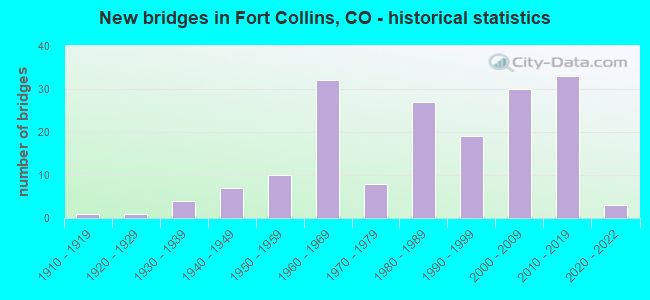
- New bridges - historical statistics
- 11910-1919
- 11920-1929
- 41930-1939
- 71940-1949
- 101950-1959
- 321960-1969
- 81970-1979
- 271980-1989
- 191990-1999
- 302000-2009
- 332010-2019
- 32020-2022
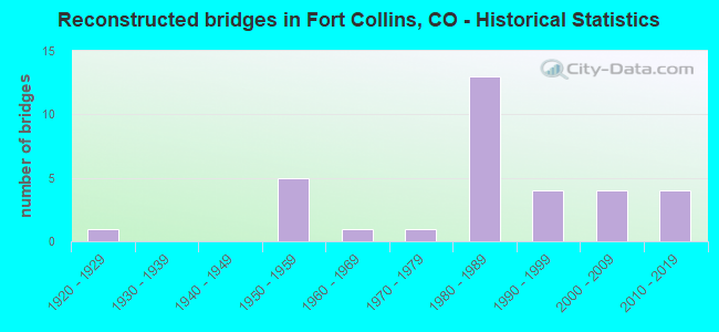
- Reconstructed bridges - Historical Statistics
- 11920-1929
- 01930-1939
- 01940-1949
- 51950-1959
- 11960-1969
- 11970-1979
- 131980-1989
- 41990-1999
- 42000-2009
- 42010-2019

- Bridge Condition - Deck
- 11.3%Very good
- 43.4%Good
- 32.1%Satisfactory
- 11.3%Fair
- 1.9%Poor
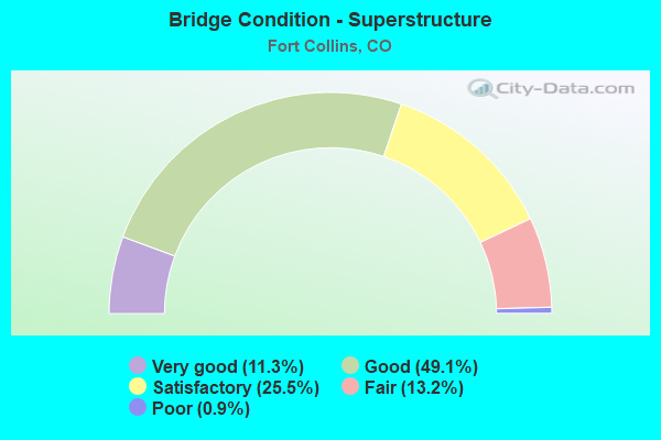
- Bridge Condition - Superstructure
- 11.3%Very good
- 49.1%Good
- 25.5%Satisfactory
- 13.2%Fair
- 0.9%Poor
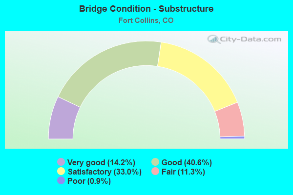
- Bridge Condition - Substructure
- 14.2%Very good
- 40.6%Good
- 33.0%Satisfactory
- 11.3%Fair
- 0.9%Poor
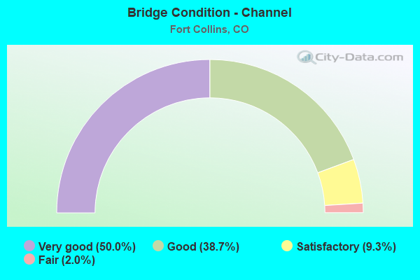
- Bridge Condition - Channel
- 50.0%Very good
- 38.7%Good
- 9.3%Satisfactory
- 2.0%Fair
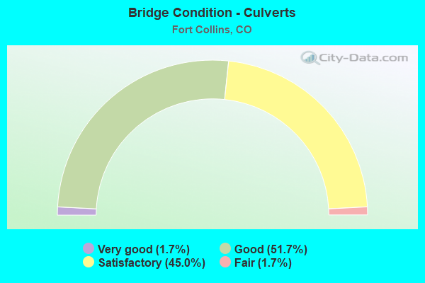
- Bridge Condition - Culverts
- 1.7%Very good
- 51.7%Good
- 45.0%Satisfactory
- 1.7%Fair
Find on map >> Show street view
Structure Number: B-16-AB, Location: ACCESS TO REST AREA SR (Lat: 40.563958, Lng: -105.006442), Route carried "on" structure: ServiceInterstate 25A, Year Built: 2008, Status: Open, Structure Length: 0.76m (2.49ft), Average Daily Traffic: 61,000 (year 2020), Truck Traffic: 11%, Average Future Daily Traffic: 91,500 (year 2040), Features Intersected: BOXELDER CREEK, Facility Carried by Structure: I 25 W FR. ROAD AR
Minimum Vertical Clearance: 30+ m (98+ ft), Kilometerpoint: 3.093, Lanes on structure: 2, Base Highway Network: Yes, Owner: State Highway Agency, Approaching Roadway Width: 9.1m (29.9ft), Material/Design: Concrete, Design/Construction: Culvert, Number Of Spans In Main Unit: 2, Length of Maximum Span: 3.7m (12.1ft), Out-to-Out Width: 24.3m (79.7ft)
Condition: Channel: Very good, Culverts: Good, Operating Rating: 36.3 metric tons, Method Used To Determine Operating Rating: Field evaluation and documented engineering judgment, Inventory Rating: 32.7 metric tons, Method Used To Determine Inventory Rating: Field evaluation and documented engineering judgment, Structural Evaluation: Better than present minimum criteria, Waterway Adequacy: Equal to present desirable criteria, Approach Roadway Alignment: Equal to present desirable criteria, Designated Inspection Frequency: Every 24 months, Inspection Date: May 2021
Find on map >> Show street view
Structure Number: B-16-AD, Location: At Woodlawn Dr. (Lat: 40.597297, Lng: -105.076564), Route carried "on" structure: US 287C, Year Built: 1930, Year Reconstructed: 1955, Status: Open, Structure Length: 0.67m (2.20ft), Average Daily Traffic: 25,000 (year 2020), Truck Traffic: 5%, Average Future Daily Traffic: 28,500 (year 2040), Design Load: HS 20, Features Intersected: LAKE CANAL, Facility Carried by Structure: US 287 ML
Minimum Vertical Clearance: 30+ m (98+ ft), Kilometerpoint: 102.932, Lanes on structure: 4, Base Highway Network: Yes, Owner: State Highway Agency, Approaching Roadway Width: 22.6m (74.1ft), Skew: 1 degrees, Material/Design: Concrete, Design/Construction: Slab, Number Of Spans In Main Unit: 1, Length of Maximum Span: 6.2m (20.3ft), Curb or Sidewalk Widths: Left: 0.6m (2.0ft), Right: 0.6m (2.0ft), Curb-To-Curb Width: 22.6m (74.1ft), Out-to-Out Width: 23.8m (78.1ft)
Condition: Deck: Fair, Superstructure: Fair, Substructure: Satisfactory, Channel: Very good, Operating Rating: 42.7 metric tons, Method Used To Determine Operating Rating: Load Factor (LF), Inventory Rating: 25.6 metric tons, Method Used To Determine Inventory Rating: Load Factor (LF), Structural Evaluation: Somewhat better than minimum adequacy, Deck Geometry: Superior to present desirable criteria, Waterway Adequacy: Equal to present desirable criteria, Approach Roadway Alignment: Equal to present desirable criteria, Designated Inspection Frequency: Every 24 months, Inspection Date: November 2021, Deck Structure Type: Concrete Cast-file-Place, Wearing Surface/Protective System: Wearing Surface: Bituminous
Find on map >> Show street view
Structure Number: B-16-AJ, Location: 0.9 MI N OF JCT SH 1 (Lat: 40.624100, Lng: -105.087008), Route carried "on" structure: US 287C, Year Built: 2012, Status: Open, Structure Length: 1.16m (3.81ft), Average Daily Traffic: 11,000 (year 2020), Truck Traffic: 8%, Average Future Daily Traffic: 11,660 (year 2040), Design Load: HL 93, Features Intersected: DRAW, Facility Carried by Structure: US 287 ML
Minimum Vertical Clearance: 30+ m (98+ ft), Kilometerpoint: 106.247, Lanes on structure: 5, Base Highway Network: Yes, Owner: State Highway Agency, Approaching Roadway Width: 26.8m (87.9ft), Skew: 3 degrees, Material/Design: Concrete, Design/Construction: Culvert, Number Of Spans In Main Unit: 2, Length of Maximum Span: 5.6m (18.4ft), Curb or Sidewalk Widths: Left: 2.3m (7.5ft), Right: 2.3m (7.5ft), Curb-To-Curb Width: 26.8m (87.9ft), Out-to-Out Width: 38.9m (127.6ft)
Condition: Channel: Very good, Culverts: Good, Operating Rating: 43.7 metric tons, Method Used To Determine Operating Rating: Load and Resistance Factor Rating (LRFR) rating reported by rating factor(RF) method using HL-93 loadings, Inventory Rating: 33.7 metric tons, Method Used To Determine Inventory Rating: Load and Resistance Factor Rating (LRFR) rating reported by rating factor(RF) method using HL-93 loadings, Structural Evaluation: Better than present minimum criteria, Deck Geometry: Superior to present desirable criteria, Waterway Adequacy: Equal to present desirable criteria, Approach Roadway Alignment: Equal to present desirable criteria, Designated Inspection Frequency: Every 24 months, Inspection Date: September 2021
Find on map >> Show street view
Structure Number: B-16-AL, Location: 2.2 MI N OF FT COLLINS (Lat: 40.644483, Lng: -105.073519), Route carried "on" structure: State highway 1A, Year Built: 1911, Year Reconstructed: 1934, Status: Open, Structure Length: 1.11m (3.64ft), Average Daily Traffic: 7,900 (year 2020), Truck Traffic: 3%, Average Future Daily Traffic: 11,060 (year 2040), Design Load: H 15, Features Intersected: LARIMER CO CANAL, Facility Carried by Structure: SH 1 ML
Minimum Vertical Clearance: 30+ m (98+ ft), Kilometerpoint: 3.513, Lanes on structure: 2, Owner: State Highway Agency, Approaching Roadway Width: 12.2m (40.0ft), Skew: 4 degrees, Material/Design: Steel, Design/Construction: Stringer/Multi-beam, Number Of Spans In Main Unit: 1, Length of Maximum Span: 10.0m (32.8ft), Curb-To-Curb Width: 9.1m (29.9ft), Out-to-Out Width: 10.2m (33.5ft)
Condition: Deck: Fair, Superstructure: Fair, Substructure: Fair, Channel: Good, Operating Rating: 49.0 metric tons, Method Used To Determine Operating Rating: Load Factor (LF), Inventory Rating: 29.0 metric tons, Method Used To Determine Inventory Rating: Load Factor (LF), Structural Evaluation: Somewhat better than minimum adequacy, Deck Geometry: High priority of corrective action, Waterway Adequacy: Equal to present desirable criteria, Approach Roadway Alignment: Equal to present desirable criteria, Length Of Structure Improvement: 1.13m (3.71ft), Designated Inspection Frequency: Every 24 months, Inspection Date: March 2021, Bridge Improvement Cost: $45,000, Roadway Improvement Cost: $4,000, Total Project Cost: $67,000, Deck Structure Type: Concrete Cast-file-Place, Wearing Surface/Protective System: Wearing Surface: Bituminous
Find on map >> Show street view
Structure Number: B-16-AMA, Location: FORT COLLINS (Lat: 40.566519, Lng: -105.001750), Route carried "on" structure: City street , Year Built: 2018, Status: Open, Structure Length: 6.87m (22.54ft), Average Daily Traffic: 12,514 (year 2008), Truck Traffic: 14%, Average Future Daily Traffic: 23,777 (year 2028), Design Load: HL 93, Features Intersected: I 25 ML, Facility Carried by Structure: PROSPECT ROAD
Minimum Vertical Clearance: 30+ m (98+ ft), Kilometerpoint: 0.000, Lanes on structure: 2, Lanes under structure: 4, Base Highway Network: Yes, Owner: State Highway Agency, Approaching Roadway Width: 24.4m (80.1ft), Skew: 20 degrees, Material/Design: Concrete continuous, Design/Construction: Tee Beam, Number Of Spans In Main Unit: 2, Length of Maximum Span: 33.9m (111.2ft), Curb or Sidewalk Widths: Left: 3.0m (9.8ft), Right: 3.0m (9.8ft), Curb-To-Curb Width: 24.4m (80.1ft), Out-to-Out Width: 36.0m (118.1ft)
Condition: Deck: Very good, Superstructure: Good, Substructure: Very good, Operating Rating: 68.0 metric tons, Method Used To Determine Operating Rating: Load and Resistance Factor Rating (LRFR) rating reported by rating factor(RF) method using HL-93 loadings, Inventory Rating: 42.1 metric tons, Method Used To Determine Inventory Rating: Load and Resistance Factor Rating (LRFR) rating reported by rating factor(RF) method using HL-93 loadings, Structural Evaluation: Better than present minimum criteria, Deck Geometry: Superior to present desirable criteria, Underclear: Meets minimum limits, Approach Roadway Alignment: Equal to present desirable criteria, Designated Inspection Frequency: Every 24 months, Inspection Date: June 2021, Deck Structure Type: Concrete Precast Panels, Wearing Surface/Protective System: Wearing Surface: Bituminous, Membrane: Built-up, Deck Protection: Epoxy Coated Reinforcing
Find on map >> Show street view
Structure Number: B-16-AR, Location: 1.8 MI E OF JCT US 287 (Lat: 40.580744, Lng: -105.043756), Route carried "on" structure: State highway 14C, Year Built: 1967, Status: Open, Structure Length: 0.91m (2.99ft), Average Daily Traffic: 33,000 (year 2020), Truck Traffic: 5%, Average Future Daily Traffic: 46,200 (year 2040), Design Load: HS 20, Features Intersected: CACHE LA POUDRE DITCH 2, Facility Carried by Structure: SH 14 ML
Minimum Vertical Clearance: 30+ m (98+ ft), Kilometerpoint: 3.209, Lanes on structure: 8, Base Highway Network: Yes, Owner: State Highway Agency, Approaching Roadway Width: 33.8m (110.9ft), Skew: 25 degrees, Material/Design: Concrete, Design/Construction: Culvert, Number Of Spans In Main Unit: 1, Length of Maximum Span: 9.1m (29.9ft)
Condition: Channel: Good, Culverts: Satisfactory, Operating Rating: 36.3 metric tons, Method Used To Determine Operating Rating: Field evaluation and documented engineering judgment, Inventory Rating: 32.7 metric tons, Method Used To Determine Inventory Rating: Field evaluation and documented engineering judgment, Structural Evaluation: Equal to present minimum criteria, Waterway Adequacy: Equal to present desirable criteria, Approach Roadway Alignment: Equal to present desirable criteria, Designated Inspection Frequency: Every 24 months, Inspection Date: November 2021
Find on map >> Show street view
Structure Number: B-16-BF, Location: 11.3 MI N OF JCT US 34 (Lat: 40.570461, Lng: -105.001114), Route carried "on" structure: Interstate 25A, Year Built: 1966, Year Reconstructed: 1989, Status: Open, Structure Length: 0.98m (3.22ft), Average Daily Traffic: 55,000 (year 2020), Truck Traffic: 11%, Average Future Daily Traffic: 83,050 (year 2040), Features Intersected: TIMNATH DITCH, Facility Carried by Structure: I 25 ML
Minimum Vertical Clearance: 30+ m (98+ ft), Kilometerpoint: 4.239, Lanes on structure: 9, Base Highway Network: Yes, Owner: State Highway Agency, Approaching Roadway Width: 42.7m (140.1ft), Skew: 16 degrees, Material/Design: Concrete, Design/Construction: Culvert, Number Of Spans In Main Unit: 1, Length of Maximum Span: 9.8m (32.2ft), Out-to-Out Width: 71.9m (235.9ft)
Condition: Channel: Very good, Culverts: Satisfactory, Operating Rating: 89.8 metric tons, Method Used To Determine Operating Rating: Field evaluation and documented engineering judgment, Inventory Rating: 89.8 metric tons, Method Used To Determine Inventory Rating: Field evaluation and documented engineering judgment, Structural Evaluation: Equal to present minimum criteria, Waterway Adequacy: Equal to present desirable criteria, Approach Roadway Alignment: Equal to present desirable criteria, Designated Inspection Frequency: Every 24 months, Inspection Date: March 2021
Find on map >> Show street view
Structure Number: B-16-BK, Location: 11.3 MI N OF JCT SH 34 (Lat: 40.570300, Lng: -105.001100), Route carried "on" structure: Interstate 25A, Year Built: 1966, Year Reconstructed: 1988, Status: Open, Structure Length: 1.19m (3.90ft), Average Daily Traffic: 55,000 (year 2020), Truck Traffic: 11%, Average Future Daily Traffic: 83,050 (year 2040), Design Load: HS 20, Features Intersected: LAKE CANAL, Facility Carried by Structure: I 25 ML
Minimum Vertical Clearance: 30+ m (98+ ft), Kilometerpoint: 4.222, Lanes on structure: 9, Base Highway Network: Yes, Owner: State Highway Agency, Approaching Roadway Width: 43.0m (141.1ft), Skew: 6 degrees, Material/Design: Concrete, Design/Construction: Culvert, Number Of Spans In Main Unit: 1, Length of Maximum Span: 11.9m (39.0ft), Out-to-Out Width: 71.6m (234.9ft)
Condition: Channel: Very good, Culverts: Satisfactory, Operating Rating: 89.8 metric tons, Method Used To Determine Operating Rating: Field evaluation and documented engineering judgment, Inventory Rating: 89.8 metric tons, Method Used To Determine Inventory Rating: Field evaluation and documented engineering judgment, Structural Evaluation: Equal to present minimum criteria, Waterway Adequacy: Equal to present desirable criteria, Approach Roadway Alignment: Equal to present desirable criteria, Length Of Structure Improvement: 1.19m (3.90ft), Designated Inspection Frequency: Every 24 months, Inspection Date: March 2021, Bridge Improvement Cost: $330,000, Roadway Improvement Cost: $33,000, Total Project Cost: $495,000
Find on map >> Show street view
Structure Number: B-16-E, Location: FT COLLINS (Lat: 40.537400, Lng: -105.076894), Route carried "on" structure: US 287C, Year Built: 1948, Year Reconstructed: 2018, Status: Open, Structure Length: 0.74m (2.43ft), Average Daily Traffic: 37,000 (year 2020), Truck Traffic: 3%, Average Future Daily Traffic: 39,590 (year 2040), Design Load: H 20, Features Intersected: LARIMER COUNTY CANAL, Facility Carried by Structure: US 287 ML
Minimum Vertical Clearance: 30+ m (98+ ft), Kilometerpoint: 96.285, Lanes on structure: 9, Base Highway Network: Yes, Owner: State Highway Agency, Approaching Roadway Width: 34.9m (114.5ft), Skew: 23 degrees, Material/Design: Concrete, Design/Construction: Slab, Number Of Spans In Main Unit: 1, Length of Maximum Span: 6.9m (22.6ft), Curb or Sidewalk Widths: Left: 3.2m (10.5ft), Right: 0.0m, Curb-To-Curb Width: 30.6m (100.4ft), Out-to-Out Width: 34.3m (112.5ft)
Condition: Deck: Satisfactory, Superstructure: Satisfactory, Substructure: Satisfactory, Channel: Very good, Operating Rating: 45.4 metric tons, Method Used To Determine Operating Rating: Load Factor (LF), Inventory Rating: 22.4 metric tons, Method Used To Determine Inventory Rating: Load Factor (LF), Structural Evaluation: Somewhat better than minimum adequacy, Deck Geometry: High priority of replacement, Waterway Adequacy: Superior to present desirable criteria, Approach Roadway Alignment: Equal to present desirable criteria, Designated Inspection Frequency: Every 24 months, Inspection Date: November 2021, Deck Structure Type: Concrete Cast-file-Place, Wearing Surface/Protective System: Wearing Surface: Bituminous
Find on map >> Show street view
Structure Number: B-16-EA, Location: 1.6 MI N OF JCT SH 14 (Lat: 40.604233, Lng: -105.001153), Route carried "on" structure: Interstate 25A, Year Built: 1950, Year Reconstructed: 1989, Status: Open, Structure Length: 1.48m (4.86ft), Average Daily Traffic: 19,000 (year 2020), Truck Traffic: 12%, Average Future Daily Traffic: 28,880 (year 2040), Design Load: HS 20, Features Intersected: WINDSOR RES,CANAL DITCH, Facility Carried by Structure: I 25 ML NBND
Minimum Vertical Clearance: 30+ m (98+ ft), Kilometerpoint: 435.680, Lanes on structure: 2, Base Highway Network: Yes, Owner: State Highway Agency, Approaching Roadway Width: 11.6m (38.1ft), Skew: 10 degrees, Material/Design: Steel, Design/Construction: Stringer/Multi-beam, Number Of Spans In Main Unit: 1, Length of Maximum Span: 13.7m (44.9ft), Curb-To-Curb Width: 11.6m (38.1ft), Out-to-Out Width: 12.3m (40.4ft)
Condition: Deck: Good, Superstructure: Good, Substructure: Good, Channel: Very good, Operating Rating: 68.5 metric tons, Method Used To Determine Operating Rating: Load Factor (LF), Inventory Rating: 41.1 metric tons, Method Used To Determine Inventory Rating: Load Factor (LF), Structural Evaluation: Better than present minimum criteria, Deck Geometry: Equal to present minimum criteria, Waterway Adequacy: Equal to present desirable criteria, Approach Roadway Alignment: Equal to present desirable criteria, Designated Inspection Frequency: Every 24 months, Inspection Date: March 2021, Deck Structure Type: Concrete Cast-file-Place, Wearing Surface/Protective System: Wearing Surface: Other, Membrane: Other, Deck Protection: Epoxy Coated Reinforcing
Find on map >> Show street view
Structure Number: B-16-ES, Location: 0.5 MI N OF JCT SH 14 (Lat: 40.588281, Lng: -105.001406), Route carried "on" structure: Interstate 25A, Year Built: 1966, Year Reconstructed: 1989, Status: Open, Structure Length: 3.81m (12.50ft), Average Daily Traffic: 19,000 (year 2020), Truck Traffic: 12%, Average Future Daily Traffic: 28,880 (year 2040), Design Load: HS 20+Mod, Features Intersected: BNSF RR, Facility Carried by Structure: I 25 ML SBND
Minimum Vertical Clearance: 30+ m (98+ ft), Kilometerpoint: 433.913, Lanes on structure: 2, Base Highway Network: Yes, Owner: State Highway Agency, Approaching Roadway Width: 11.6m (38.1ft), Skew: 10 degrees, Material/Design: Steel, Design/Construction: Stringer/Multi-beam, Number Of Spans In Main Unit: 3, Length of Maximum Span: 13.9m (45.6ft), Curb-To-Curb Width: 11.6m (38.1ft), Out-to-Out Width: 12.3m (40.4ft)
Condition: Deck: Good, Superstructure: Good, Substructure: Good, Operating Rating: 57.3 metric tons, Method Used To Determine Operating Rating: Load Factor (LF), Inventory Rating: 34.3 metric tons, Method Used To Determine Inventory Rating: Load Factor (LF), Structural Evaluation: Better than present minimum criteria, Deck Geometry: Equal to present minimum criteria, Underclear: Better than present minimum criteria, Approach Roadway Alignment: Equal to present desirable criteria, Designated Inspection Frequency: Every 24 months, Inspection Date: May 2021, Deck Structure Type: Concrete Cast-file-Place, Wearing Surface/Protective System: Wearing Surface: Monolithic Concrete, Deck Protection: Epoxy Coated Reinforcing
Find on map >> Show street view
Structure Number: B-16-ET, Location: 0.5 MI N OF JCT SH 14 (Lat: 40.588281, Lng: -105.001078), Route carried "on" structure: Interstate 25A, Year Built: 1966, Year Reconstructed: 1989, Status: Open, Structure Length: 3.81m (12.50ft), Average Daily Traffic: 19,000 (year 2020), Truck Traffic: 12%, Average Future Daily Traffic: 28,880 (year 2040), Design Load: HS 20, Features Intersected: BNSF RR, Facility Carried by Structure: I 25 ML NBND
Minimum Vertical Clearance: 30+ m (98+ ft), Kilometerpoint: 433.913, Lanes on structure: 2, Base Highway Network: Yes, Owner: State Highway Agency, Approaching Roadway Width: 11.6m (38.1ft), Skew: 10 degrees, Material/Design: Steel, Design/Construction: Stringer/Multi-beam, Number Of Spans In Main Unit: 3, Length of Maximum Span: 13.9m (45.6ft), Curb-To-Curb Width: 11.6m (38.1ft), Out-to-Out Width: 12.3m (40.4ft)
Condition: Deck: Good, Superstructure: Good, Substructure: Satisfactory, Operating Rating: 57.4 metric tons, Method Used To Determine Operating Rating: Load Factor (LF), Inventory Rating: 34.4 metric tons, Method Used To Determine Inventory Rating: Load Factor (LF), Structural Evaluation: Equal to present minimum criteria, Deck Geometry: Equal to present minimum criteria, Underclear: Superior to present desirable criteria, Approach Roadway Alignment: Equal to present desirable criteria, Designated Inspection Frequency: Every 24 months, Inspection Date: May 2021, Deck Structure Type: Concrete Cast-file-Place, Wearing Surface/Protective System: Wearing Surface: Bituminous, Membrane: Preformed Fabric, Deck Protection: Epoxy Coated Reinforcing
Find on map >> Show street view
Structure Number: B-16-EV, Location: 1 MI E OF JCT 287 (Lat: 40.581264, Lng: -105.059769), Route carried "on" structure: State highway 14C, Year Built: 2015, Status: Open, Structure Length: 11.61m (38.09ft), Average Daily Traffic: 26,000 (year 2020), Truck Traffic: 4%, Average Future Daily Traffic: 34,320 (year 2040), Design Load: HL 93, Features Intersected: CACHE LA POUDRE RIVER, Facility Carried by Structure: SH 14 ML
Minimum Vertical Clearance: 30+ m (98+ ft), Kilometerpoint: 1.852, Lanes on structure: 5, Base Highway Network: Yes, Owner: State Highway Agency, Approaching Roadway Width: 23.8m (78.1ft), Skew: 30 degrees, Material/Design: Prestressed concrete continuous, Design/Construction: Box Beam or Girders - Multiple, Number Of Spans In Main Unit: 5, Length of Maximum Span: 25.6m (84.0ft), Curb or Sidewalk Widths: Left: 2.4m (7.9ft), Right: 2.4m (7.9ft), Curb-To-Curb Width: 23.8m (78.1ft), Out-to-Out Width: 37.8m (124.0ft)
Condition: Deck: Good, Superstructure: Good, Substructure: Good, Channel: Very good, Operating Rating: 61.6 metric tons, Method Used To Determine Operating Rating: Load and Resistance Factor Rating (LRFR) rating reported by rating factor(RF) method using HL-93 loadings, Inventory Rating: 47.6 metric tons, Method Used To Determine Inventory Rating: Load and Resistance Factor Rating (LRFR) rating reported by rating factor(RF) method using HL-93 loadings, Structural Evaluation: Better than present minimum criteria, Deck Geometry: Better than present minimum criteria, Waterway Adequacy: Equal to present desirable criteria, Approach Roadway Alignment: Equal to present desirable criteria, Designated Inspection Frequency: Every 24 months, Inspection Date: October 2021, Deck Structure Type: Concrete Cast-file-Place, Wearing Surface/Protective System: Wearing Surface: Bituminous, Membrane: Preformed Fabric, Deck Protection: Epoxy Coated Reinforcing
Find on map >> Show street view
Structure Number: B-16-EW, Location: I-25/MULBERRY INTERCHANGE (Lat: 40.580956, Lng: -105.001736), Route carried "on" structure: State highway 14C, Year Built: 1966, Status: Open, Structure Length: 7.25m (23.79ft), Average Daily Traffic: 17,500 (year 2020), Truck Traffic: 6%, Average Future Daily Traffic: 24,500 (year 2040), Design Load: HS 20+Mod, Features Intersected: I 25 ML, Facility Carried by Structure: SH 14 ML EBND
Minimum Vertical Clearance: 30+ m (98+ ft), Kilometerpoint: 6.769, Lanes on structure: 3, Lanes under structure: 6, Base Highway Network: Yes, Owner: State Highway Agency, Approaching Roadway Width: 13.4m (44.0ft), Material/Design: Concrete continuous, Design/Construction: Tee Beam, Number Of Spans In Main Unit: 4, Length of Maximum Span: 22.3m (73.2ft), Curb-To-Curb Width: 12.8m (42.0ft), Out-to-Out Width: 14.0m (45.9ft)
Condition: Deck: Fair, Superstructure: Fair, Substructure: Satisfactory, Operating Rating: 51.7 metric tons, Method Used To Determine Operating Rating: Load Factor (LF), Inventory Rating: 31.0 metric tons, Method Used To Determine Inventory Rating: Load Factor (LF), Structural Evaluation: Somewhat better than minimum adequacy, Deck Geometry: Meets minimum limits, Underclear: High priority of corrective action, Approach Roadway Alignment: Equal to present desirable criteria, Length Of Structure Improvement: 7.26m (23.82ft), Designated Inspection Frequency: Every 24 months, Inspection Date: May 2021, Bridge Improvement Cost: $403,000, Roadway Improvement Cost: $40,000, Total Project Cost: $604,000, Deck Structure Type: Other, Wearing Surface/Protective System: Wearing Surface: Other, Membrane: Other
Find on map >> Show street view
Structure Number: B-16-EX, Location: I-25 MULBERRY INTERCHANGE (Lat: 40.581153, Lng: -105.001731), Route carried "on" structure: State highway 14C, Year Built: 1966, Status: Open, Structure Length: 7.25m (23.79ft), Average Daily Traffic: 17,500 (year 2020), Truck Traffic: 6%, Average Future Daily Traffic: 24,500 (year 2040), Design Load: HS 20, Features Intersected: I 25 ML, Facility Carried by Structure: SH 14 ML WBND
Minimum Vertical Clearance: 30+ m (98+ ft), Kilometerpoint: 6.769, Lanes on structure: 3, Lanes under structure: 6, Base Highway Network: Yes, Owner: State Highway Agency, Approaching Roadway Width: 13.4m (44.0ft), Material/Design: Concrete continuous, Design/Construction: Tee Beam, Number Of Spans In Main Unit: 4, Length of Maximum Span: 22.3m (73.2ft), Curb-To-Curb Width: 12.8m (42.0ft), Out-to-Out Width: 14.0m (45.9ft)
Condition: Deck: Fair, Superstructure: Fair, Substructure: Fair, Operating Rating: 60.4 metric tons, Method Used To Determine Operating Rating: Load Factor (LF), Inventory Rating: 36.2 metric tons, Method Used To Determine Inventory Rating: Load Factor (LF), Structural Evaluation: Somewhat better than minimum adequacy, Deck Geometry: Meets minimum limits, Underclear: High priority of corrective action, Approach Roadway Alignment: Equal to present desirable criteria, Length Of Structure Improvement: 7.26m (23.82ft), Designated Inspection Frequency: Every 24 months, Inspection Date: May 2021, Bridge Improvement Cost: $1,038,000, Roadway Improvement Cost: $104,000, Total Project Cost: $1,557,000, Deck Structure Type: Concrete Cast-file-Place, Wearing Surface/Protective System: Wearing Surface: Bituminous, Membrane: Built-up
Find on map >> Show street view
Structure Number: B-16-EY, Location: 0.5 MI S OF JCT SH 14 (Lat: 40.574197, Lng: -105.001103), Route carried "on" structure: Interstate 25A, Year Built: 1968, Year Reconstructed: 1988, Status: Open, Structure Length: 1.32m (4.33ft), Average Daily Traffic: 55,000 (year 2020), Truck Traffic: 11%, Average Future Daily Traffic: 83,050 (year 2040), Design Load: HS 20, Features Intersected: BOX ELDER CREEK, Facility Carried by Structure: I 25 ML
Minimum Vertical Clearance: 30+ m (98+ ft), Kilometerpoint: 432.350, Lanes on structure: 8, Base Highway Network: Yes, Owner: State Highway Agency, Approaching Roadway Width: 40.2m (131.9ft), Material/Design: Concrete, Design/Construction: Culvert, Number Of Spans In Main Unit: 4, Length of Maximum Span: 3.0m (9.8ft), Out-to-Out Width: 72.9m (239.2ft)
Condition: Channel: Good, Culverts: Fair, Structural Evaluation: Somewhat better than minimum adequacy, Waterway Adequacy: Equal to present desirable criteria, Approach Roadway Alignment: Equal to present desirable criteria, Designated Inspection Frequency: Every 24 months, Inspection Date: May 2021
Find on map >> Show street view
Structure Number: B-16-FA, Location: 2 MI N OF JCT SH 14 (Lat: 40.610731, Lng: -105.001058), Route carried "on" structure: Interstate 25A, Year Built: 1950, Status: Open, Structure Length: 0.64m (2.10ft), Average Daily Traffic: 19,000 (year 2020), Truck Traffic: 12%, Average Future Daily Traffic: 28,880 (year 2040), Design Load: HS 20, Features Intersected: FLOOD DRAINAGE, Facility Carried by Structure: I 25 ML NBND
Minimum Vertical Clearance: 30+ m (98+ ft), Kilometerpoint: 436.401, Lanes on structure: 2, Base Highway Network: Yes, Owner: State Highway Agency, Approaching Roadway Width: 11.6m (38.1ft), Material/Design: Concrete, Design/Construction: Culvert, Number Of Spans In Main Unit: 2, Length of Maximum Span: 3.0m (9.8ft), Out-to-Out Width: 16.5m (54.1ft)
Condition: Channel: Very good, Culverts: Good, Operating Rating: 36.3 metric tons, Method Used To Determine Operating Rating: Field evaluation and documented engineering judgment, Inventory Rating: 32.7 metric tons, Method Used To Determine Inventory Rating: Field evaluation and documented engineering judgment, Structural Evaluation: Better than present minimum criteria, Waterway Adequacy: Equal to present desirable criteria, Approach Roadway Alignment: Equal to present desirable criteria, Designated Inspection Frequency: Every 24 months, Inspection Date: May 2021
Find on map >> Show street view
Structure Number: B-16-FB, Location: 2 MI N OF JCT SH 14 (Lat: 40.612650, Lng: -105.001053), Route carried "on" structure: Interstate 25A, Year Built: 1950, Status: Open, Structure Length: 0.64m (2.10ft), Average Daily Traffic: 14,000 (year 2020), Truck Traffic: 19%, Average Future Daily Traffic: 21,560 (year 2040), Design Load: HS 20, Features Intersected: FLOOD DRAINAGE, Facility Carried by Structure: I 25 ML NBND
Minimum Vertical Clearance: 30+ m (98+ ft), Kilometerpoint: 436.613, Lanes on structure: 3, Base Highway Network: Yes, Owner: State Highway Agency, Approaching Roadway Width: 19.5m (64.0ft), Material/Design: Concrete, Design/Construction: Culvert, Number Of Spans In Main Unit: 2, Length of Maximum Span: 3.0m (9.8ft), Out-to-Out Width: 35.1m (115.2ft)
Condition: Channel: Good, Culverts: Satisfactory, Operating Rating: 36.3 metric tons, Method Used To Determine Operating Rating: Field evaluation and documented engineering judgment, Inventory Rating: 32.7 metric tons, Method Used To Determine Inventory Rating: Field evaluation and documented engineering judgment, Structural Evaluation: Equal to present minimum criteria, Waterway Adequacy: Equal to present desirable criteria, Approach Roadway Alignment: Equal to present desirable criteria, Designated Inspection Frequency: Every 24 months, Inspection Date: May 2021
Find on map >> Show street view
Structure Number: B-16-FC, Location: 2.3 MI N OF JCT SH 14 (Lat: 40.613883, Lng: -105.001028), Route carried "on" structure: Interstate 25A, Year Built: 1950, Status: Open, Structure Length: 0.64m (2.10ft), Average Daily Traffic: 14,000 (year 2020), Truck Traffic: 19%, Average Future Daily Traffic: 21,560 (year 2040), Design Load: HS 20, Features Intersected: FLOOD DRAINAGE, Facility Carried by Structure: I 25 ML NBND
Minimum Vertical Clearance: 30+ m (98+ ft), Kilometerpoint: 436.752, Lanes on structure: 3, Base Highway Network: Yes, Owner: State Highway Agency, Approaching Roadway Width: 19.8m (65.0ft), Material/Design: Concrete, Design/Construction: Culvert, Number Of Spans In Main Unit: 2, Length of Maximum Span: 3.0m (9.8ft), Out-to-Out Width: 19.8m (65.0ft)
Condition: Channel: Very good, Culverts: Good, Operating Rating: 36.3 metric tons, Method Used To Determine Operating Rating: Field evaluation and documented engineering judgment, Inventory Rating: 32.7 metric tons, Method Used To Determine Inventory Rating: Field evaluation and documented engineering judgment, Structural Evaluation: Better than present minimum criteria, Waterway Adequacy: Equal to present desirable criteria, Approach Roadway Alignment: Equal to present desirable criteria, Designated Inspection Frequency: Every 24 months, Inspection Date: May 2021
Find on map >> Show street view
Structure Number: B-16-FD, Location: 2.5 MI N OF JCT SH 14 (Lat: 40.616194, Lng: -105.001044), Route carried "on" structure: Interstate 25A, Year Built: 1950, Status: Open, Structure Length: 1.34m (4.40ft), Average Daily Traffic: 14,000 (year 2020), Truck Traffic: 19%, Average Future Daily Traffic: 21,560 (year 2040), Design Load: HS 20, Features Intersected: FLOOD DRAINAGE, Facility Carried by Structure: I 25 ML NBND
Minimum Vertical Clearance: 30+ m (98+ ft), Kilometerpoint: 437.008, Lanes on structure: 2, Base Highway Network: Yes, Owner: State Highway Agency, Approaching Roadway Width: 11.6m (38.1ft), Material/Design: Concrete, Design/Construction: Culvert, Number Of Spans In Main Unit: 3, Length of Maximum Span: 4.9m (16.1ft), Out-to-Out Width: 15.2m (49.9ft)
Condition: Channel: Good, Culverts: Satisfactory, Operating Rating: 36.3 metric tons, Method Used To Determine Operating Rating: Field evaluation and documented engineering judgment, Inventory Rating: 32.7 metric tons, Method Used To Determine Inventory Rating: Field evaluation and documented engineering judgment, Structural Evaluation: Equal to present minimum criteria, Waterway Adequacy: Equal to present desirable criteria, Approach Roadway Alignment: Equal to present desirable criteria, Designated Inspection Frequency: Every 24 months, Inspection Date: May 2021
Find on map >> Show street view
Structure Number: B-16-FI, Location: 6.9 MI S OF JCT SH 1 (Lat: 40.604228, Lng: -105.001547), Route carried "on" structure: Interstate 25A, Year Built: 1966, Year Reconstructed: 1989, Status: Open, Structure Length: 1.46m (4.79ft), Average Daily Traffic: 19,000 (year 2020), Truck Traffic: 12%, Average Future Daily Traffic: 28,880 (year 2040), Design Load: HS 20+Mod, Features Intersected: WINDSOR RES,CANAL DITCH, Facility Carried by Structure: I 25 ML SBND
Minimum Vertical Clearance: 30+ m (98+ ft), Kilometerpoint: 435.680, Lanes on structure: 2, Base Highway Network: Yes, Owner: State Highway Agency, Approaching Roadway Width: 11.7m (38.4ft), Skew: 10 degrees, Material/Design: Steel, Design/Construction: Stringer/Multi-beam, Number Of Spans In Main Unit: 1, Length of Maximum Span: 14.0m (45.9ft), Curb-To-Curb Width: 11.7m (38.4ft), Out-to-Out Width: 12.4m (40.7ft)
Condition: Deck: Good, Superstructure: Satisfactory, Substructure: Satisfactory, Channel: Very good, Operating Rating: 68.0 metric tons, Method Used To Determine Operating Rating: Load Factor (LF), Inventory Rating: 40.8 metric tons, Method Used To Determine Inventory Rating: Load Factor (LF), Structural Evaluation: Equal to present minimum criteria, Deck Geometry: Equal to present minimum criteria, Waterway Adequacy: Equal to present desirable criteria, Approach Roadway Alignment: Equal to present desirable criteria, Designated Inspection Frequency: Every 24 months, Inspection Date: March 2021, Deck Structure Type: Concrete Cast-file-Place, Wearing Surface/Protective System: Wearing Surface: Other, Membrane: Other, Deck Protection: Epoxy Coated Reinforcing
Find on map >> Show street view
Structure Number: B-16-FJ, Location: 1.6 MI N OF JCT SH 14 (Lat: 40.604228, Lng: -105.000986), Route carried "on" structure: ServiceInterstate 25A, Year Built: 1966, Status: Open, Structure Length: 1.46m (4.79ft), Average Daily Traffic: 38,000 (year 2020), Truck Traffic: 12%, Average Future Daily Traffic: 57,760 (year 2040), Design Load: HS 20, Features Intersected: WINDSOR RES, CANAL SR, Facility Carried by Structure: I 25 SERVICE RD
Minimum Vertical Clearance: 30+ m (98+ ft), Kilometerpoint: 8.358, Lanes on structure: 2, Base Highway Network: Yes, Owner: State Highway Agency, Approaching Roadway Width: 8.5m (27.9ft), Skew: 10 degrees, Material/Design: Concrete, Design/Construction: Tee Beam, Number Of Spans In Main Unit: 1, Length of Maximum Span: 14.0m (45.9ft), Curb-To-Curb Width: 7.3m (24.0ft), Out-to-Out Width: 8.2m (26.9ft)
Condition: Deck: Satisfactory, Superstructure: Satisfactory, Substructure: Satisfactory, Channel: Very good, Operating Rating: 42.2 metric tons, Method Used To Determine Operating Rating: Load Factor (LF), Inventory Rating: 25.2 metric tons, Method Used To Determine Inventory Rating: Load Factor (LF), Structural Evaluation: Equal to present minimum criteria, Deck Geometry: High priority of replacement, Waterway Adequacy: Equal to present desirable criteria, Approach Roadway Alignment: Equal to present desirable criteria, Length Of Structure Improvement: 2.14m (7.02ft), Designated Inspection Frequency: Every 24 months, Inspection Date: March 2021, Bridge Improvement Cost: $205,000, Roadway Improvement Cost: $20,000, Total Project Cost: $307,000, Deck Structure Type: Concrete Cast-file-Place, Wearing Surface/Protective System: Wearing Surface: Bituminous
Find on map >> Show street view
Structure Number: B-16-FL, Location: EAST OF FT COLLINS (Lat: 40.624522, Lng: -105.001769), Route carried "on" structure: County highway , Year Built: 1966, Status: Open, Structure Length: 8.20m (26.90ft), Average Daily Traffic: 28,347 (year 2020), Truck Traffic: 15%, Average Future Daily Traffic: 878 (year 2028), Design Load: HS 20+Mod, Features Intersected: I 25 ML, Facility Carried by Structure: COUNTY ROAD 52
Minimum Vertical Clearance: 30+ m (98+ ft), Kilometerpoint: 1.931, Lanes on structure: 2, Lanes under structure: 6, Owner: State Highway Agency, Approaching Roadway Width: 7.9m (25.9ft), Material/Design: Steel, Design/Construction: Stringer/Multi-beam, Number Of Spans In Main Unit: 3, Number Of Approach Spans: 1, Length of Maximum Span: 22.7m (74.5ft), Curb-To-Curb Width: 7.3m (24.0ft), Out-to-Out Width: 8.5m (27.9ft)
Condition: Deck: Fair, Superstructure: Good, Substructure: Fair, Operating Rating: 50.8 metric tons, Method Used To Determine Operating Rating: Load Factor (LF), Inventory Rating: 30.9 metric tons, Method Used To Determine Inventory Rating: Load Factor (LF), Structural Evaluation: Somewhat better than minimum adequacy, Deck Geometry: High priority of replacement, Underclear: High priority of corrective action, Approach Roadway Alignment: Equal to present desirable criteria, Designated Inspection Frequency: Every 24 months, Inspection Date: May 2021, Deck Structure Type: Concrete Cast-file-Place, Wearing Surface/Protective System: Wearing Surface: Bituminous, Membrane: Built-up
Find on map >> Show street view
Structure Number: B-16-FP, Location: 7.3 MI N OF JCT US 34 (Lat: 40.512644, Lng: -105.077133), Route carried "on" structure: US 287C, Year Built: 1975, Status: Open, Structure Length: 1.38m (4.53ft), Average Daily Traffic: 31,000 (year 2020), Truck Traffic: 2%, Average Future Daily Traffic: 36,890 (year 2040), Design Load: HS 20, Features Intersected: FOSSIL CREEK, Facility Carried by Structure: US 287 ML
Minimum Vertical Clearance: 30+ m (98+ ft), Kilometerpoint: 93.538, Lanes on structure: 5, Base Highway Network: Yes, Owner: State Highway Agency, Approaching Roadway Width: 26.8m (87.9ft), Skew: 4 degrees, Material/Design: Concrete, Design/Construction: Culvert, Number Of Spans In Main Unit: 3, Length of Maximum Span: 5.0m (16.4ft), Out-to-Out Width: 35.5m (116.5ft)
Condition: Channel: Good, Culverts: Satisfactory, Operating Rating: 36.3 metric tons, Method Used To Determine Operating Rating: Field evaluation and documented engineering judgment, Inventory Rating: 32.7 metric tons, Method Used To Determine Inventory Rating: Field evaluation and documented engineering judgment, Structural Evaluation: Equal to present minimum criteria, Waterway Adequacy: Equal to present desirable criteria, Approach Roadway Alignment: Equal to present desirable criteria, Designated Inspection Frequency: Every 48 months, Inspection Date: September 2021
Find on map >> Show street view
Structure Number: B-16-FV, Location: EAST OF FT COLLINS (Lat: 40.610142, Lng: -105.001828), Route carried "on" structure: City street , Year Built: 1985, Status: Open, Structure Length: 7.64m (25.07ft), Average Daily Traffic: 1,117 (year 2008), Truck Traffic: 1%, Average Future Daily Traffic: 2,121 (year 2028), Features Intersected: I 25 ML, Facility Carried by Structure: BREWERY RD
Minimum Vertical Clearance: 30+ m (98+ ft), Kilometerpoint: 3.118, Lanes on structure: 2, Lanes under structure: 4, Owner: State Highway Agency, Approaching Roadway Width: 17.1m (56.1ft), Material/Design: Prestressed concrete continuous, Design/Construction: Stringer/Multi-beam, Number Of Spans In Main Unit: 2, Length of Maximum Span: 38.0m (124.7ft), Curb-To-Curb Width: 17.1m (56.1ft), Out-to-Out Width: 18.0m (59.1ft)
Condition: Deck: Good, Superstructure: Good, Substructure: Good, Operating Rating: 53.7 metric tons, Method Used To Determine Operating Rating: Load Factor (LF), Inventory Rating: 32.2 metric tons, Method Used To Determine Inventory Rating: Load Factor (LF), Structural Evaluation: Better than present minimum criteria, Deck Geometry: Superior to present desirable criteria, Underclear: Better than present minimum criteria, Approach Roadway Alignment: Equal to present desirable criteria, Designated Inspection Frequency: Every 24 months, Inspection Date: May 2021, Deck Structure Type: Concrete Cast-file-Place, Wearing Surface/Protective System: Wearing Surface: Bituminous, Membrane: Preformed Fabric, Deck Protection: Epoxy Coated Reinforcing
Find on map >> Show street view
Structure Number: B-16-G, Location: 0.1 MI S OF FTHILLS PKWY (Lat: 40.542336, Lng: -105.076900), Route carried "on" structure: US 287C, Year Built: 1948, Year Reconstructed: 2017, Status: Open, Structure Length: 0.70m (2.30ft), Average Daily Traffic: 37,000 (year 2020), Truck Traffic: 3%, Average Future Daily Traffic: 40,330 (year 2040), Design Load: H 20, Features Intersected: PED/BIKE TRAIL, Facility Carried by Structure: US 287 ML
Minimum Vertical Clearance: 30+ m (98+ ft), Kilometerpoint: 96.834, Lanes on structure: 6, Base Highway Network: Yes, Owner: State Highway Agency, Approaching Roadway Width: 22.6m (74.1ft), Skew: 12 degrees, Material/Design: Concrete, Design/Construction: Slab, Number Of Spans In Main Unit: 1, Length of Maximum Span: 6.7m (22.0ft), Curb-To-Curb Width: 22.6m (74.1ft), Out-to-Out Width: 31.2m (102.4ft)
Condition: Deck: Good, Superstructure: Good, Substructure: Good, Operating Rating: 39.2 metric tons, Method Used To Determine Operating Rating: Load Factor (LF), Inventory Rating: 22.0 metric tons, Method Used To Determine Inventory Rating: Load Factor (LF), Structural Evaluation: Somewhat better than minimum adequacy, Deck Geometry: Meets minimum limits, Approach Roadway Alignment: Equal to present desirable criteria, Designated Inspection Frequency: Every 24 months, Inspection Date: November 2021, Deck Structure Type: Concrete Cast-file-Place, Wearing Surface/Protective System: Wearing Surface: Bituminous
Find on map >> Show street view
Structure Number: B-16-GK, Location: FORT COLLINS (Lat: 40.594775, Lng: -105.076519), Route carried "on" structure: US 287C, Year Built: 1995, Status: Open, Structure Length: 6.95m (22.80ft), Average Daily Traffic: 27,000 (year 2020), Truck Traffic: 5%, Average Future Daily Traffic: 31,590 (year 2040), Design Load: HS 20, Features Intersected: CACHE LA POUDRE RIVER, Facility Carried by Structure: US 287 ML
Minimum Vertical Clearance: 30+ m (98+ ft), Kilometerpoint: 102.655, Lanes on structure: 4, Base Highway Network: Yes, Owner: State Highway Agency, Approaching Roadway Width: 22.6m (74.1ft), Skew: 30 degrees, Material/Design: Prestressed concrete continuous, Design/Construction: Box Beam or Girders - Single/Spread, Number Of Spans In Main Unit: 4, Length of Maximum Span: 17.0m (55.8ft), Curb or Sidewalk Widths: Left: 3.2m (10.5ft), Right: 3.2m (10.5ft), Curb-To-Curb Width: 23.2m (76.1ft), Out-to-Out Width: 34.4m (112.9ft)
Condition: Deck: Good, Superstructure: Good, Substructure: Good, Channel: Satisfactory, Operating Rating: 65.7 metric tons, Method Used To Determine Operating Rating: Load Factor (LF), Inventory Rating: 40.3 metric tons, Method Used To Determine Inventory Rating: Load Factor (LF), Structural Evaluation: Better than present minimum criteria, Deck Geometry: Superior to present desirable criteria, Waterway Adequacy: Equal to present desirable criteria, Approach Roadway Alignment: Equal to present desirable criteria, Designated Inspection Frequency: Every 24 months, Inspection Date: September 2021, Deck Structure Type: Concrete Cast-file-Place, Wearing Surface/Protective System: Wearing Surface: Bituminous, Membrane: Preformed Fabric, Deck Protection: Epoxy Coated Reinforcing
Find on map >> Show street view
Structure Number: B-16-GL, Location: MULBERRY andTIMBERLINE RD (Lat: 40.580850, Lng: -105.033367), Route carried "on" structure: State highway 14C, Year Built: 1999, Status: Open, Structure Length: 2.39m (7.84ft), Average Daily Traffic: 33,000 (year 2020), Truck Traffic: 5%, Average Future Daily Traffic: 46,200 (year 2040), Design Load: HS 25 or greater, Features Intersected: DRY CREEK, Facility Carried by Structure: SH 14 ML
Minimum Vertical Clearance: 30+ m (98+ ft), Kilometerpoint: 4.091, Lanes on structure: 7, Base Highway Network: Yes, Owner: State Highway Agency, Approaching Roadway Width: 27.4m (89.9ft), Skew: 30 degrees, Material/Design: Prestressed concrete continuous, Design/Construction: Slab, Number Of Spans In Main Unit: 2, Length of Maximum Span: 11.5m (37.7ft), Curb or Sidewalk Widths: Left: 2.3m (7.5ft), Right: 3.0m (9.8ft), Curb-To-Curb Width: 29.4m (96.5ft), Out-to-Out Width: 39.5m (129.6ft)
Condition: Deck: Satisfactory, Superstructure: Good, Substructure: Satisfactory, Channel: Very good, Operating Rating: 74.3 metric tons, Method Used To Determine Operating Rating: Load Factor (LF), Inventory Rating: 44.5 metric tons, Method Used To Determine Inventory Rating: Load Factor (LF), Structural Evaluation: Equal to present minimum criteria, Deck Geometry: Somewhat better than minimum adequacy, Waterway Adequacy: Equal to present desirable criteria, Approach Roadway Alignment: Equal to present desirable criteria, Designated Inspection Frequency: Every 24 months, Inspection Date: October 2021, Deck Structure Type: Concrete Cast-file-Place, Wearing Surface/Protective System: Wearing Surface: Bituminous, Membrane: Preformed Fabric, Deck Protection: Epoxy Coated Reinforcing
Find on map >> Show street view
Structure Number: B-16-H, Location: FORT COLLINS (Lat: 40.562019, Lng: -105.076828), Route carried "on" structure: US 287C, Year Built: 1948, Year Reconstructed: 1959, Status: Open, Structure Length: 1.17m (3.84ft), Average Daily Traffic: 33,000 (year 2020), Truck Traffic: 3%, Average Future Daily Traffic: 34,650 (year 2040), Design Load: HS 20+Mod, Features Intersected: SPRING CREEK, Facility Carried by Structure: US 287 ML
Minimum Vertical Clearance: 30+ m (98+ ft), Kilometerpoint: 99.013, Lanes on structure: 6, Base Highway Network: Yes, Owner: State Highway Agency, Approaching Roadway Width: 24.4m (80.1ft), Skew: 23 degrees, Material/Design: Steel, Design/Construction: Stringer/Multi-beam, Number Of Spans In Main Unit: 1, Length of Maximum Span: 9.8m (32.2ft), Curb or Sidewalk Widths: Left: 1.2m (3.9ft), Right: 1.2m (3.9ft), Curb-To-Curb Width: 25.6m (84.0ft), Out-to-Out Width: 28.0m (91.9ft)
Condition: Deck: Satisfactory, Superstructure: Satisfactory, Substructure: Satisfactory, Channel: Very good, Operating Rating: 47.8 metric tons, Method Used To Determine Operating Rating: Load Factor (LF), Inventory Rating: 28.7 metric tons, Method Used To Determine Inventory Rating: Load Factor (LF), Structural Evaluation: Equal to present minimum criteria, Deck Geometry: Somewhat better than minimum adequacy, Waterway Adequacy: Equal to present desirable criteria, Approach Roadway Alignment: Equal to present desirable criteria, Designated Inspection Frequency: Every 24 months, Underwater Inspection Frequency: Every 60 months, Inspection Date: November 2021, Underwater Inspection Date: July 2020, Deck Structure Type: Concrete Cast-file-Place, Wearing Surface/Protective System: Wearing Surface: Bituminous
Find on map >> Show street view
Structure Number: B-16-HC, Location: MILE MRKR 270.314 (Lat: 40.595603, Lng: -105.001708), Route carried "on" structure: County highway , Year Built: 2018, Status: Open, Structure Length: 6.48m (21.26ft), Average Daily Traffic: 4,929 (year 2008), Truck Traffic: 10%, Average Future Daily Traffic: 9,365 (year 2028), Design Load: H 20, Features Intersected: I 25 ML, Facility Carried by Structure: COUNTY ROAD 48
Minimum Vertical Clearance: 30+ m (98+ ft), Kilometerpoint: 0.000, Lanes on structure: 3, Lanes under structure: 4, Base Highway Network: Yes, Toll: On toll road, Owner: State Highway Agency, Approaching Roadway Width: 15.8m (51.8ft), Material/Design: Prestressed concrete continuous, Design/Construction: Stringer/Multi-beam, Number Of Spans In Main Unit: 2, Length of Maximum Span: 32.0m (105.0ft), Curb or Sidewalk Widths: Left: 2.0m (6.6ft), Right: 2.0m (6.6ft), Curb-To-Curb Width: 15.8m (51.8ft), Out-to-Out Width: 20.7m (67.9ft)
Condition: Deck: Good, Superstructure: Good, Substructure: Very good, Operating Rating: 51.8 metric tons, Method Used To Determine Operating Rating: Load and Resistance Factor Rating (LRFR) rating reported by rating factor(RF) method using HL-93 loadings, Inventory Rating: 35.6 metric tons, Method Used To Determine Inventory Rating: Load and Resistance Factor Rating (LRFR) rating reported by rating factor(RF) method using HL-93 loadings, Structural Evaluation: Better than present minimum criteria, Deck Geometry: Better than present minimum criteria, Underclear: Superior to present desirable criteria, Approach Roadway Alignment: Equal to present desirable criteria, Designated Inspection Frequency: Every 24 months, Inspection Date: May 2021, Deck Structure Type: Concrete Precast Panels, Wearing Surface/Protective System: Wearing Surface: Bituminous, Membrane: Built-up, Deck Protection: Epoxy Coated Reinforcing
Find on map >> Show street view
Structure Number: B-16-L, Location: 2.6 MI E OF JCT US 287 (Lat: 40.580989, Lng: -105.027711), Route carried "on" structure: State highway 14C, Year Built: 1967, Status: Open, Structure Length: 0.76m (2.49ft), Average Daily Traffic: 32,000 (year 2020), Truck Traffic: 5%, Average Future Daily Traffic: 45,440 (year 2040), Design Load: HS 20, Features Intersected: CACHE LA POUDRE DITCH 2, Facility Carried by Structure: SH 14 ML
Minimum Vertical Clearance: 30+ m (98+ ft), Kilometerpoint: 0.422, Lanes on structure: 9, Base Highway Network: Yes, Owner: State Highway Agency, Approaching Roadway Width: 35.4m (116.1ft), Skew: 24 degrees, Material/Design: Concrete, Design/Construction: Culvert, Number Of Spans In Main Unit: 1, Length of Maximum Span: 7.6m (24.9ft)
Condition: Channel: Good, Culverts: Satisfactory, Operating Rating: 36.3 metric tons, Method Used To Determine Operating Rating: Field evaluation and documented engineering judgment, Inventory Rating: 32.7 metric tons, Method Used To Determine Inventory Rating: Field evaluation and documented engineering judgment, Structural Evaluation: Equal to present minimum criteria, Waterway Adequacy: Equal to present desirable criteria, Approach Roadway Alignment: Equal to present desirable criteria, Designated Inspection Frequency: Every 24 months, Inspection Date: November 2021
Find on map >> Show street view
Structure Number: B-16-T, Location: 0.85 MI W OF JCT I-25 (Lat: 40.581072, Lng: -105.017481), Route carried "on" structure: State highway 14C, Year Built: 1948, Year Reconstructed: 1966, Status: Open, Structure Length: 0.66m (2.17ft), Average Daily Traffic: 32,000 (year 2020), Truck Traffic: 5%, Average Future Daily Traffic: 44,160 (year 2040), Design Load: HS 20, Features Intersected: LAKE CANAL, Facility Carried by Structure: SH 14 ML
Minimum Vertical Clearance: 30+ m (98+ ft), Kilometerpoint: 5.435, Lanes on structure: 6, Base Highway Network: Yes, Owner: State Highway Agency, Approaching Roadway Width: 36.0m (118.1ft), Skew: 13 degrees, Material/Design: Concrete, Design/Construction: Culvert, Number Of Spans In Main Unit: 1, Length of Maximum Span: 6.6m (21.7ft), Out-to-Out Width: 55.7m (182.7ft)
Condition: Channel: Very good, Culverts: Good, Operating Rating: 36.3 metric tons, Method Used To Determine Operating Rating: Field evaluation and documented engineering judgment, Inventory Rating: 32.7 metric tons, Method Used To Determine Inventory Rating: Field evaluation and documented engineering judgment, Structural Evaluation: Better than present minimum criteria, Waterway Adequacy: Equal to present desirable criteria, Approach Roadway Alignment: Equal to present desirable criteria, Designated Inspection Frequency: Every 24 months, Inspection Date: October 2021
Find on map >> Show street view
Structure Number: B-16-W, Location: 0.2 MI S of SH1 (Lat: 40.613286, Lng: -105.076311), Route carried "on" structure: US 287C, Year Built: 1949, Year Reconstructed: 1955, Status: Open, Structure Length: 1.58m (5.18ft), Average Daily Traffic: 24,000 (year 2020), Truck Traffic: 6%, Average Future Daily Traffic: 26,880 (year 2040), Design Load: HS 20, Features Intersected: LARIMER-WELD CANAL, Facility Carried by Structure: US 287 ML
Minimum Vertical Clearance: 30+ m (98+ ft), Kilometerpoint: 104.709, Lanes on structure: 4, Base Highway Network: Yes, Owner: State Highway Agency, Approaching Roadway Width: 19.5m (64.0ft), Skew: 2 degrees, Material/Design: Steel, Design/Construction: Stringer/Multi-beam, Number Of Spans In Main Unit: 1, Length of Maximum Span: 13.7m (44.9ft), Curb or Sidewalk Widths: Left: 0.6m (2.0ft), Right: 0.6m (2.0ft), Curb-To-Curb Width: 22.6m (74.1ft), Out-to-Out Width: 23.8m (78.1ft)
Condition: Deck: Satisfactory, Superstructure: Satisfactory, Substructure: Satisfactory, Channel: Very good, Operating Rating: 29.3 metric tons, Method Used To Determine Operating Rating: Load Factor (LF), Inventory Rating: 17.6 metric tons, Method Used To Determine Inventory Rating: Load Factor (LF), Structural Evaluation: Meets minimum limits, Deck Geometry: Superior to present desirable criteria, Waterway Adequacy: Equal to present desirable criteria, Approach Roadway Alignment: Equal to present desirable criteria, Designated Inspection Frequency: Every 24 months, Inspection Date: November 2021, Deck Structure Type: Concrete Cast-file-Place, Wearing Surface/Protective System: Wearing Surface: Bituminous
Find on map >> Show street view
Structure Number: B-17-BB, Location: 3.5 MI S OF JCT SH 14 (Lat: 40.530736, Lng: -104.993036), Route carried "on" structure: Interstate 25A, Year Built: 1965, Year Reconstructed: 1988, Status: Open, Structure Length: 9.24m (30.31ft), Average Daily Traffic: 30,500 (year 2020), Truck Traffic: 11%, Average Future Daily Traffic: 45,750 (year 2040), Design Load: HS 20, Features Intersected: CACHE LA POUDRE RIVER, Facility Carried by Structure: I 25 ML SBND
Minimum Vertical Clearance: 30+ m (98+ ft), Kilometerpoint: 427.451, Lanes on structure: 2, Base Highway Network: Yes, Owner: State Highway Agency, Approaching Roadway Width: 14.0m (45.9ft), Skew: 10 degrees, Material/Design: Steel continuous, Design/Construction: Stringer/Multi-beam, Number Of Spans In Main Unit: 4, Length of Maximum Span: 25.0m (82.0ft), Curb-To-Curb Width: 13.3m (43.6ft), Out-to-Out Width: 14.0m (45.9ft)
Condition: Deck: Good, Superstructure: Good, Substructure: Satisfactory, Channel: Satisfactory, Operating Rating: 47.7 metric tons, Method Used To Determine Operating Rating: Load Factor (LF), Inventory Rating: 28.3 metric tons, Method Used To Determine Inventory Rating: Load Factor (LF), Structural Evaluation: Equal to present minimum criteria, Deck Geometry: Superior to present desirable criteria, Waterway Adequacy: Better than present minimum criteria, Approach Roadway Alignment: Equal to present desirable criteria, Designated Inspection Frequency: Every 24 months, Inspection Date: June 2021, Deck Structure Type: Concrete Cast-file-Place, Wearing Surface/Protective System: Wearing Surface: Other, Membrane: Other, Deck Protection: Epoxy Coated Reinforcing
Find on map >> Show street view
Structure Number: B-17-BC, Location: 1.1 MI N OF JCT SH 68 (Lat: 40.538814, Lng: -104.995389), Route carried "on" structure: Interstate 25A, Year Built: 1966, Year Reconstructed: 1988, Status: Open, Structure Length: 5.25m (17.22ft), Average Daily Traffic: 30,500 (year 2020), Truck Traffic: 11%, Average Future Daily Traffic: 45,750 (year 2040), Design Load: HS 20, Features Intersected: RR SPUR, Facility Carried by Structure: I 25 ML NBND
Minimum Vertical Clearance: 30+ m (98+ ft), Kilometerpoint: 428.369, Lanes on structure: 3, Base Highway Network: Yes, Owner: State Highway Agency, Approaching Roadway Width: 11.6m (38.1ft), Skew: 14 degrees, Material/Design: Steel continuous, Design/Construction: Stringer/Multi-beam, Number Of Spans In Main Unit: 3, Length of Maximum Span: 19.2m (63.0ft), Curb-To-Curb Width: 13.4m (44.0ft), Out-to-Out Width: 14.2m (46.6ft)
Condition: Deck: Satisfactory, Superstructure: Good, Substructure: Good, Operating Rating: 63.4 metric tons, Method Used To Determine Operating Rating: Load Factor (LF), Inventory Rating: 38.0 metric tons, Method Used To Determine Inventory Rating: Load Factor (LF), Structural Evaluation: Better than present minimum criteria, Deck Geometry: High priority of replacement, Underclear: Equal to present minimum criteria, Approach Roadway Alignment: Equal to present desirable criteria, Length Of Structure Improvement: 5.24m (17.19ft), Designated Inspection Frequency: Every 24 months, Inspection Date: June 2021, Bridge Improvement Cost: $288,000, Roadway Improvement Cost: $29,000, Total Project Cost: $432,000, Deck Structure Type: Concrete Cast-file-Place, Wearing Surface/Protective System: Wearing Surface: Monolithic Concrete
Find on map >> Show street view
Structure Number: B-17-BD, Location: 2.9 MI S OF JCT SH 14 (Lat: 40.539078, Lng: -104.995819), Route carried "on" structure: Interstate 25A, Year Built: 1966, Year Reconstructed: 1988, Status: Open, Structure Length: 5.24m (17.19ft), Average Daily Traffic: 30,500 (year 2020), Truck Traffic: 11%, Average Future Daily Traffic: 45,750 (year 2040), Design Load: HS 20, Features Intersected: RR SPUR, Facility Carried by Structure: I 25 ML SBND
Minimum Vertical Clearance: 30+ m (98+ ft), Kilometerpoint: 428.406, Lanes on structure: 2, Base Highway Network: Yes, Owner: State Highway Agency, Approaching Roadway Width: 11.6m (38.1ft), Skew: 14 degrees, Material/Design: Steel continuous, Design/Construction: Stringer/Multi-beam, Number Of Spans In Main Unit: 3, Length of Maximum Span: 19.0m (62.3ft), Curb-To-Curb Width: 11.6m (38.1ft), Out-to-Out Width: 12.3m (40.4ft)
Condition: Deck: Satisfactory, Superstructure: Good, Substructure: Good, Operating Rating: 62.8 metric tons, Method Used To Determine Operating Rating: Load Factor (LF), Inventory Rating: 37.6 metric tons, Method Used To Determine Inventory Rating: Load Factor (LF), Structural Evaluation: Better than present minimum criteria, Deck Geometry: Equal to present minimum criteria, Underclear: Equal to present minimum criteria, Approach Roadway Alignment: Equal to present desirable criteria, Designated Inspection Frequency: Every 24 months, Inspection Date: June 2021, Deck Structure Type: Concrete Cast-file-Place, Wearing Surface/Protective System: Wearing Surface: Monolithic Concrete, Deck Protection: Epoxy Coated Reinforcing
Find on map >> Show street view
Structure Number: B-17-BN, Location: WEST OF WINDSOR (Lat: 40.508567, Lng: -104.992086), Route carried "on" structure: County highway , Year Built: 1965, Status: Open, Structure Length: 6.43m (21.10ft), Average Daily Traffic: 3,576 (year 2008), Truck Traffic: 5%, Average Future Daily Traffic: 6,795 (year 2028), Design Load: H 20, Features Intersected: I 25 ML, Facility Carried by Structure: COUNTY ROAD 36
Minimum Vertical Clearance: 30+ m (98+ ft), Kilometerpoint: 0.722, Lanes on structure: 2, Lanes under structure: 4, Owner: State Highway Agency, Approaching Roadway Width: 7.9m (25.9ft), Material/Design: Steel, Design/Construction: Stringer/Multi-beam, Number Of Spans In Main Unit: 2, Number Of Approach Spans: 2, Length of Maximum Span: 19.7m (64.6ft), Curb-To-Curb Width: 7.3m (24.0ft), Out-to-Out Width: 8.5m (27.9ft)
Condition: Deck: Satisfactory, Superstructure: Satisfactory, Substructure: Fair, Operating Rating: 30.1 metric tons, Method Used To Determine Operating Rating: Load Factor (LF), Inventory Rating: 18.1 metric tons, Method Used To Determine Inventory Rating: Load Factor (LF), Structural Evaluation: Somewhat better than minimum adequacy, Deck Geometry: High priority of replacement, Underclear: Equal to present minimum criteria, Approach Roadway Alignment: Equal to present desirable criteria, Designated Inspection Frequency: Every 24 months, Inspection Date: June 2021, Deck Structure Type: Concrete Cast-file-Place, Wearing Surface/Protective System: Wearing Surface: Bituminous, Membrane: Preformed Fabric
Find on map >> Show street view
Structure Number: B-17-DI, Location: 8.5 MI N OF JCT US 34 (Lat: 40.530678, Lng: -104.993356), Route carried "on" structure: Interstate 25A, Year Built: 1948, Year Reconstructed: 1988, Status: Open, Structure Length: 9.25m (30.35ft), Average Daily Traffic: 30,500 (year 2020), Truck Traffic: 11%, Average Future Daily Traffic: 45,750 (year 2040), Design Load: HS 20, Features Intersected: CACHE LA POUDRE RIVER, Facility Carried by Structure: I 25 ML NBND
Minimum Vertical Clearance: 30+ m (98+ ft), Kilometerpoint: 427.450, Lanes on structure: 2, Base Highway Network: Yes, Owner: State Highway Agency, Approaching Roadway Width: 11.6m (38.1ft), Skew: 10 degrees, Material/Design: Steel continuous, Design/Construction: Stringer/Multi-beam, Number Of Spans In Main Unit: 4, Length of Maximum Span: 25.0m (82.0ft), Curb-To-Curb Width: 11.6m (38.1ft), Out-to-Out Width: 12.3m (40.4ft)
Condition: Deck: Good, Superstructure: Good, Substructure: Good, Channel: Good, Operating Rating: 66.4 metric tons, Method Used To Determine Operating Rating: Load Factor (LF), Inventory Rating: 39.7 metric tons, Method Used To Determine Inventory Rating: Load Factor (LF), Structural Evaluation: Better than present minimum criteria, Deck Geometry: Equal to present minimum criteria, Waterway Adequacy: Equal to present minimum criteria, Approach Roadway Alignment: Equal to present desirable criteria, Designated Inspection Frequency: Every 24 months, Inspection Date: June 2021, Deck Structure Type: Concrete Cast-file-Place, Wearing Surface/Protective System: Wearing Surface: Other, Membrane: Other
Find on map >> Show street view
Structure Number: B-17-DJ, Location: 0.4 MI E OF JCT I 25 (Lat: 40.581006, Lng: -104.993444), Route carried "on" structure: State highway 14C, Year Built: 1985, Status: Open, Structure Length: 1.99m (6.53ft), Average Daily Traffic: 19,000 (year 2020), Truck Traffic: 9%, Average Future Daily Traffic: 28,310 (year 2040), Design Load: HS 20, Features Intersected: BOX ELDER CREEK, Facility Carried by Structure: SH 14 ML
Minimum Vertical Clearance: 30+ m (98+ ft), Kilometerpoint: 7.475, Lanes on structure: 5, Base Highway Network: Yes, Owner: State Highway Agency, Approaching Roadway Width: 26.8m (87.9ft), Material/Design: Concrete, Design/Construction: Culvert, Number Of Spans In Main Unit: 3, Length of Maximum Span: 6.5m (21.3ft), Curb-To-Curb Width: 27.1m (88.9ft), Out-to-Out Width: 27.7m (90.9ft)
Condition: Channel: Good, Culverts: Satisfactory, Operating Rating: 36.3 metric tons, Method Used To Determine Operating Rating: Field evaluation and documented engineering judgment, Inventory Rating: 32.7 metric tons, Method Used To Determine Inventory Rating: Field evaluation and documented engineering judgment, Structural Evaluation: Equal to present minimum criteria, Deck Geometry: Superior to present desirable criteria, Waterway Adequacy: Equal to present desirable criteria, Approach Roadway Alignment: Equal to present desirable criteria, Designated Inspection Frequency: Every 48 months, Inspection Date: October 2019
Find on map >> Show street view
Structure Number: B-17-DN, Location: IN FORT COLLINS (Lat: 40.610717, Lng: -105.000211), Route carried "on" structure: Ramp Interstate 25A, Year Built: 1985, Status: Open, Structure Length: 0.64m (2.10ft), Average Daily Traffic: 19,000 (year 2020), Truck Traffic: 12%, Average Future Daily Traffic: 28,880 (year 2040), Design Load: HS 20, Features Intersected: BOX ELDER CRK OVERFLOW R, Facility Carried by Structure: RAMP TO I 25 NBND
Minimum Vertical Clearance: 30+ m (98+ ft), Kilometerpoint: 0.058, Lanes on structure: 1, Base Highway Network: Yes, Owner: State Highway Agency, Approaching Roadway Width: 7.6m (24.9ft), Material/Design: Concrete, Design/Construction: Culvert, Number Of Spans In Main Unit: 2, Length of Maximum Span: 2.9m (9.5ft), Out-to-Out Width: 43.9m (144.0ft)
Condition: Channel: Very good, Culverts: Good, Inventory Rating: 87.0 metric tons, Method Used To Determine Inventory Rating: Load Factor (LF), Structural Evaluation: Better than present minimum criteria, Waterway Adequacy: Equal to present desirable criteria, Approach Roadway Alignment: Equal to present desirable criteria, Designated Inspection Frequency: Every 48 months, Inspection Date: May 2019
Find on map >> Show street view
Structure Number: B-17-DO, Location: 0.1 MI. EAST OF I 25 (Lat: 40.610100, Lng: -104.999831), Route carried "on" structure: ServiceInterstate 25A, Year Built: 1985, Status: Open, Structure Length: 1.16m (3.81ft), Average Daily Traffic: 38,000 (year 2020), Truck Traffic: 12%, Average Future Daily Traffic: 57,760 (year 2040), Design Load: HS 20, Features Intersected: BOX ELDER CRK OVRFLOW AR, Facility Carried by Structure: I25 SR/BREWERY RD
Minimum Vertical Clearance: 30+ m (98+ ft), Kilometerpoint: 3.281, Lanes on structure: 2, Base Highway Network: Yes, Owner: State Highway Agency, Approaching Roadway Width: 18.0m (59.1ft), Material/Design: Concrete, Design/Construction: Culvert, Number Of Spans In Main Unit: 3, Length of Maximum Span: 4.3m (14.1ft), Out-to-Out Width: 45.1m (148.0ft)
Condition: Channel: Very good, Culverts: Good, Operating Rating: 89.8 metric tons, Method Used To Determine Operating Rating: Field evaluation and documented engineering judgment, Inventory Rating: 89.8 metric tons, Method Used To Determine Inventory Rating: Field evaluation and documented engineering judgment, Structural Evaluation: Better than present minimum criteria, Waterway Adequacy: Equal to present desirable criteria, Approach Roadway Alignment: Equal to present desirable criteria, Designated Inspection Frequency: Every 48 months, Inspection Date: May 2019