Bridge Statistics for Fort Collins, Colorado (CO)
Condition, Traffic, Stress, Structural Evaluation, Project Costs
- National Bridge Inventory (NBI) Statistics
- 175Number of bridges
- 1,227ft / 374mTotal length
- $6,118,000Total costs
- 2,515,941Total average daily traffic
- 219,293Total average daily truck traffic
- National Bridge Inventory (NBI) Registered Bridges for Fort Collins
- No street view available for this location
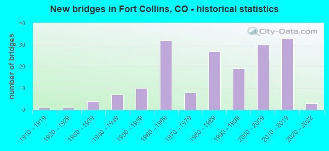
- New bridges - historical statistics
- 11910-1919
- 11920-1929
- 41930-1939
- 71940-1949
- 101950-1959
- 321960-1969
- 81970-1979
- 271980-1989
- 191990-1999
- 302000-2009
- 332010-2019
- 32020-2022
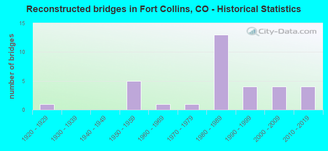
- Reconstructed bridges - Historical Statistics
- 11920-1929
- 01930-1939
- 01940-1949
- 51950-1959
- 11960-1969
- 11970-1979
- 131980-1989
- 41990-1999
- 42000-2009
- 42010-2019

- Bridge Condition - Deck
- 11.3%Very good
- 43.4%Good
- 32.1%Satisfactory
- 11.3%Fair
- 1.9%Poor
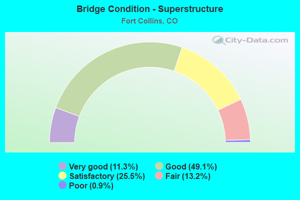
- Bridge Condition - Superstructure
- 11.3%Very good
- 49.1%Good
- 25.5%Satisfactory
- 13.2%Fair
- 0.9%Poor
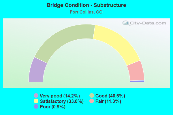
- Bridge Condition - Substructure
- 14.2%Very good
- 40.6%Good
- 33.0%Satisfactory
- 11.3%Fair
- 0.9%Poor
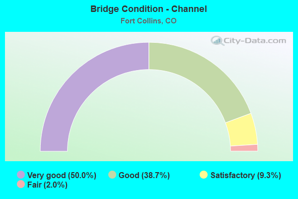
- Bridge Condition - Channel
- 50.0%Very good
- 38.7%Good
- 9.3%Satisfactory
- 2.0%Fair
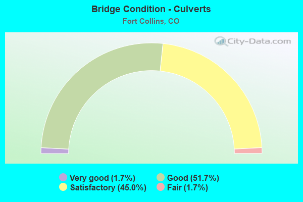
- Bridge Condition - Culverts
- 1.7%Very good
- 51.7%Good
- 45.0%Satisfactory
- 1.7%Fair
Find on map >> Show street view
Structure Number: LR56-0.3-11-A, Location: 0.3 Mi E of Co Rd 11 (Lat: 40.653750, Lng: -105.029472), Route carried "on" structure: County highway , Year Built: 1999, Status: Open, Structure Length: 0.98m (3.22ft), Average Daily Traffic: 163 (year 2021), Truck Traffic: 13%, Average Future Daily Traffic: 204 (year 2041), Design Load: HS 20, Features Intersected: Larimer County Canal, Facility Carried by Structure: County Road 56
Minimum Vertical Clearance: 30+ m (98+ ft), Kilometerpoint: 3.843, Lanes on structure: 2, Owner: County Highway Agency, Approaching Roadway Width: 8.2m (26.9ft), Skew: 1 degrees, Material/Design: Concrete, Design/Construction: Frame, Number Of Spans In Main Unit: 1, Length of Maximum Span: 9.1m (29.9ft), Curb-To-Curb Width: 11.6m (38.1ft), Out-to-Out Width: 12.4m (40.7ft)
Condition: Deck: Satisfactory, Superstructure: Satisfactory, Substructure: Good, Channel: Very good, Operating Rating: 55.3 metric tons, Method Used To Determine Operating Rating: Load Factor (LF), Inventory Rating: 33.4 metric tons, Method Used To Determine Inventory Rating: Load Factor (LF), Structural Evaluation: Equal to present minimum criteria, Deck Geometry: Superior to present desirable criteria, Waterway Adequacy: Equal to present desirable criteria, Approach Roadway Alignment: Equal to present desirable criteria, Designated Inspection Frequency: Every 24 months, Inspection Date: March 2021, Deck Structure Type: Concrete Cast-file-Place, Wearing Surface/Protective System: Wearing Surface: Bituminous, Deck Protection: Epoxy Coated Reinforcing
Find on map >> Show street view
Structure Number: LR56-0.6-11-A, Location: 0.6 Mi E of Co Rd 11 (Lat: 40.653722, Lng: -105.025556), Route carried "on" structure: County highway , Year Built: 2004, Status: Open, Structure Length: 2.30m (7.55ft), Average Daily Traffic: 163 (year 2021), Truck Traffic: 15%, Average Future Daily Traffic: 204 (year 2041), Design Load: HS 20, Features Intersected: Larimer County Canal, Facility Carried by Structure: County Road 56
Minimum Vertical Clearance: 30+ m (98+ ft), Kilometerpoint: 4.173, Lanes on structure: 2, Owner: County Highway Agency, Approaching Roadway Width: 7.9m (25.9ft), Skew: 4 degrees, Material/Design: Prestressed concrete, Design/Construction: Stringer/Multi-beam, Number Of Spans In Main Unit: 1, Length of Maximum Span: 21.1m (69.2ft), Curb-To-Curb Width: 11.0m (36.1ft), Out-to-Out Width: 11.8m (38.7ft)
Condition: Deck: Good, Superstructure: Very good, Substructure: Good, Channel: Very good, Operating Rating: 72.1 metric tons, Method Used To Determine Operating Rating: Load Factor (LF), Inventory Rating: 43.3 metric tons, Method Used To Determine Inventory Rating: Load Factor (LF), Structural Evaluation: Better than present minimum criteria, Deck Geometry: Equal to present desirable criteria, Waterway Adequacy: Equal to present desirable criteria, Approach Roadway Alignment: Equal to present desirable criteria, Designated Inspection Frequency: Every 24 months, Inspection Date: March 2021, Deck Structure Type: Concrete Cast-file-Place, Wearing Surface/Protective System: Wearing Surface: Bituminous, Membrane: Preformed Fabric, Deck Protection: Epoxy Coated Reinforcing
Find on map >> Show street view
Structure Number: LR56-0.7-11, Location: 0.9 Mi E of Co Rd 11 (Lat: 40.653667, Lng: -105.022361), Route carried "on" structure: County highway , Year Built: 1966, Status: Open, Structure Length: 0.88m (2.89ft), Average Daily Traffic: 257 (year 2021), Truck Traffic: 9%, Average Future Daily Traffic: 321 (year 2041), Features Intersected: Larimer County Canal, Facility Carried by Structure: County Road 56
Minimum Vertical Clearance: 30+ m (98+ ft), Kilometerpoint: 4.440, Lanes on structure: 2, Owner: County Highway Agency, Approaching Roadway Width: 6.1m (20.0ft), Material/Design: Prestressed concrete, Design/Construction: Tee Beam, Number Of Spans In Main Unit: 1, Length of Maximum Span: 7.9m (25.9ft), Curb or Sidewalk Widths: Left: 0.2m (0.7ft), Right: 0.2m (0.7ft), Curb-To-Curb Width: 6.8m (22.3ft), Out-to-Out Width: 7.3m (24.0ft)
Condition: Deck: Satisfactory, Superstructure: Satisfactory, Substructure: Satisfactory, Channel: Satisfactory, Operating Rating: 30.6 metric tons, Method Used To Determine Operating Rating: Load Factor (LF), Inventory Rating: 16.4 metric tons, Method Used To Determine Inventory Rating: Load Factor (LF), Structural Evaluation: Somewhat better than minimum adequacy, Deck Geometry: Meets minimum limits, Waterway Adequacy: Equal to present desirable criteria, Approach Roadway Alignment: Equal to present desirable criteria, Designated Inspection Frequency: Every 24 months, Inspection Date: March 2021, Deck Structure Type: Other, Wearing Surface/Protective System: Wearing Surface: Bituminous
Find on map >> Show street view
Structure Number: LRSTANTONBRRD1, Location: S of E CR 32 (Lat: 40.479789, Lng: -105.064547), Route carried "on" structure: County highway , Year Built: 2016, Status: Open, Structure Length: 0.88m (2.89ft), Average Daily Traffic: 200 (year 2021), Truck Traffic: 13%, Average Future Daily Traffic: 250 (year 2041), Features Intersected: Unnamed Canal, Facility Carried by Structure: Stanton Ridge Road
Minimum Vertical Clearance: 30+ m (98+ ft), Kilometerpoint: 0.112, Lanes on structure: 2, Owner: County Highway Agency, Approaching Roadway Width: 14.8m (48.6ft), Skew: 32 degrees, Material/Design: Concrete, Design/Construction: Culvert, Number Of Spans In Main Unit: 2, Length of Maximum Span: 4.3m (14.1ft), Curb or Sidewalk Widths: Left: 1.2m (3.9ft), Right: 1.5m (4.9ft), Curb-To-Curb Width: 15.2m (49.9ft), Out-to-Out Width: 18.7m (61.4ft)
Condition: Channel: Very good, Culverts: Good, Operating Rating: 36.3 metric tons, Method Used To Determine Operating Rating: Field evaluation and documented engineering judgment, Inventory Rating: 32.7 metric tons, Method Used To Determine Inventory Rating: Field evaluation and documented engineering judgment, Structural Evaluation: Better than present minimum criteria, Deck Geometry: Superior to present desirable criteria, Waterway Adequacy: Equal to present desirable criteria, Approach Roadway Alignment: Equal to present minimum criteria, Designated Inspection Frequency: Every 24 months, Inspection Date: June 2021
Find on map >> Show street view
Structure Number: LRWOODYCRKLN1, Location: 100 FT W of CO-1 (Lat: 40.647172, Lng: -105.074025), Route carried "on" structure: County highway , Year Built: 2016, Status: Open, Structure Length: 1.20m (3.94ft), Average Daily Traffic: 96 (year 2021), Truck Traffic: 21%, Average Future Daily Traffic: 120 (year 2041), Features Intersected: Larimer County Canal, Facility Carried by Structure: Woody Creek Lane
Minimum Vertical Clearance: 30+ m (98+ ft), Kilometerpoint: 0.047, Lanes on structure: 2, Owner: County Highway Agency, Approaching Roadway Width: 8.5m (27.9ft), Material/Design: Steel, Design/Construction: Stringer/Multi-beam, Number Of Spans In Main Unit: 1, Length of Maximum Span: 11.1m (36.4ft), Curb-To-Curb Width: 8.6m (28.2ft), Out-to-Out Width: 8.9m (29.2ft)
Condition: Deck: Good, Superstructure: Good, Substructure: Good, Channel: Very good, Operating Rating: 31.1 metric tons, Method Used To Determine Operating Rating: Load Factor (LF), Inventory Rating: 18.7 metric tons, Method Used To Determine Inventory Rating: Load Factor (LF), Structural Evaluation: Somewhat better than minimum adequacy, Deck Geometry: Better than present minimum criteria, Waterway Adequacy: Equal to present desirable criteria, Approach Roadway Alignment: Equal to present desirable criteria, Designated Inspection Frequency: Every 24 months, Inspection Date: June 2021, Deck Structure Type: Concrete Cast-file-Place, Wearing Surface/Protective System: Wearing Surface: Monolithic Concrete
Find on map >> Show street view
Structure Number: B-16-AMA, Location: FORT COLLINS (Lat: 40.566519, Lng: -105.001750), Route carried "under" structure: Interstate 25A, Year Built: 2018, Structure Length: 0. m, Average Daily Traffic: 11,882 (year 2016), Truck Traffic: 11%, Features Intersected: I 25 ML, Facility Carried by Structure: PROSPECT ROAD
Minimum Vertical Clearance: 5.28m (17.32ft), Kilometerpoint: 431.976, Lanes on structure: 2, Lanes under structure: 4, Material/Design: Concrete continuous, Design/Construction: Tee Beam, Length of Maximum Span: 33.9m (111.2ft)
Find on map >> Show street view
Structure Number: B-16-EW, Location: I-25/MULBERRY INTERCHANGE (Lat: 40.580956, Lng: -105.001736), Route carried "under" structure: Interstate 25A, Year Built: 1966, Structure Length: 0. m, Average Daily Traffic: 52,000 (year 2011), Truck Traffic: 11%, Features Intersected: I 25 ML, Facility Carried by Structure: SH 14 ML EBND
Minimum Vertical Clearance: 5.56m (18.24ft), Kilometerpoint: 433.416, Lanes on structure: 3, Lanes under structure: 6, Material/Design: Concrete continuous, Design/Construction: Tee Beam, Length of Maximum Span: 22.3m (73.2ft)
Find on map >> Show street view
Structure Number: B-16-EX, Location: I-25 MULBERRY INTERCHANGE (Lat: 40.581153, Lng: -105.001731), Route carried "under" structure: Interstate 25A, Year Built: 1966, Structure Length: 0. m, Average Daily Traffic: 52,000 (year 2011), Truck Traffic: 11%, Features Intersected: I 25 ML, Facility Carried by Structure: SH 14 ML WBND
Minimum Vertical Clearance: 5.46m (17.91ft), Kilometerpoint: 433.417, Lanes on structure: 3, Lanes under structure: 6, Material/Design: Concrete continuous, Design/Construction: Tee Beam, Length of Maximum Span: 22.3m (73.2ft)
Find on map >> Show street view
Structure Number: B-16-FL, Location: EAST OF FT COLLINS (Lat: 40.624522, Lng: -105.001769), Route carried "under" structure: Interstate 25A, Year Built: 1966, Structure Length: 0. m, Average Daily Traffic: 541 (year 2016), Truck Traffic: 14%, Features Intersected: I 25 ML, Facility Carried by Structure: COUNTY ROAD 52
Minimum Vertical Clearance: 5.23m (17.16ft), Kilometerpoint: 1.931, Lanes on structure: 2, Lanes under structure: 6, Material/Design: Steel, Design/Construction: Stringer/Multi-beam, Length of Maximum Span: 22.7m (74.5ft)
Find on map >> Show street view
Structure Number: B-16-FV, Location: EAST OF FT COLLINS (Lat: 40.610142, Lng: -105.001828), Route carried "under" structure: ServiceInterstate 25A, Year Built: 1985, Structure Length: 0. m, Average Daily Traffic: 5,059 (year 2016), Truck Traffic: 13%, Features Intersected: I 25 ML, Facility Carried by Structure: BREWERY RD
Minimum Vertical Clearance: 5.26m (17.26ft), Kilometerpoint: 3.119, Lanes on structure: 2, Lanes under structure: 4, Material/Design: Prestressed concrete continuous, Design/Construction: Stringer/Multi-beam, Length of Maximum Span: 38.0m (124.7ft)
Find on map >> Show street view
Structure Number: B-16-HC, Location: MILE MRKR 270.314 (Lat: 40.595603, Lng: -105.001708), Route carried "under" structure: Interstate 25A, Year Built: 2018, Structure Length: 0. m, Average Daily Traffic: 4,556 (year 2016), Truck Traffic: 12%, Features Intersected: I 25 ML, Facility Carried by Structure: COUNTY ROAD 48
Minimum Vertical Clearance: 5.31m (17.42ft), Kilometerpoint: 435.029, Lanes on structure: 3, Lanes under structure: 4, Material/Design: Prestressed concrete continuous, Design/Construction: Stringer/Multi-beam, Length of Maximum Span: 32.0m (105.0ft)
Find on map >> Show street view
Structure Number: B-17-BN, Location: WEST OF WINDSOR (Lat: 40.508567, Lng: -104.992086), Route carried "under" structure: Interstate 25A, Year Built: 1965, Structure Length: 0. m, Average Daily Traffic: 3,120 (year 2016), Truck Traffic: 10%, Features Intersected: I 25 ML, Facility Carried by Structure: COUNTY ROAD 36
Minimum Vertical Clearance: 5.23m (17.16ft), Kilometerpoint: 0.208, Lanes on structure: 2, Lanes under structure: 4, Material/Design: Steel, Design/Construction: Stringer/Multi-beam, Length of Maximum Span: 19.7m (64.6ft)
Find on map >> Show street view
Structure Number: C-17-EN, Location: 1.5 MI NO OF JCT SH 402 (Lat: 40.399578, Lng: -104.993842), Route carried "under" structure: Interstate 25A, Year Built: 2021, Structure Length: 0. m, Average Daily Traffic: 76,000 (year 2020), Truck Traffic: 9%, Features Intersected: I 25 ML, Facility Carried by Structure: COUNTY ROAD 20E
Minimum Vertical Clearance: 5.79m (19.00ft), Kilometerpoint: 0.000, Lanes on structure: 3, Lanes under structure: 4, Material/Design: Prestressed concrete continuous, Design/Construction: Stringer/Multi-beam, Length of Maximum Span: 35.1m (115.2ft)
Find on map >> Show street view
Structure Number: C-17-FK, Location: I-25/WINDSOR INTERCHANGE (Lat: 40.479289, Lng: -104.992217), Route carried "under" structure: Interstate 25A, Year Built: 2012, Structure Length: 0. m, Average Daily Traffic: 68,000 (year 2011), Truck Traffic: 11%, Features Intersected: I 25 ML, Facility Carried by Structure: SH 392 ML
Minimum Vertical Clearance: 5.08m (16.67ft), Kilometerpoint: 422.128, Lanes on structure: 6, Lanes under structure: 6, Material/Design: Prestressed concrete continuous, Design/Construction: Box Beam or Girders - Single/Spread, Length of Maximum Span: 43.7m (143.4ft)