Bridge Statistics for Fort Collins, Colorado (CO)
Condition, Traffic, Stress, Structural Evaluation, Project Costs
- National Bridge Inventory (NBI) Statistics
- 175Number of bridges
- 1,227ft / 374mTotal length
- $6,118,000Total costs
- 2,515,941Total average daily traffic
- 219,293Total average daily truck traffic
- National Bridge Inventory (NBI) Registered Bridges for Fort Collins
- No street view available for this location
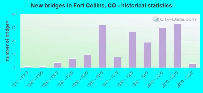
- New bridges - historical statistics
- 11910-1919
- 11920-1929
- 41930-1939
- 71940-1949
- 101950-1959
- 321960-1969
- 81970-1979
- 271980-1989
- 191990-1999
- 302000-2009
- 332010-2019
- 32020-2022
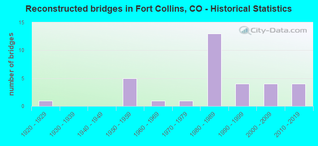
- Reconstructed bridges - Historical Statistics
- 11920-1929
- 01930-1939
- 01940-1949
- 51950-1959
- 11960-1969
- 11970-1979
- 131980-1989
- 41990-1999
- 42000-2009
- 42010-2019

- Bridge Condition - Deck
- 11.3%Very good
- 43.4%Good
- 32.1%Satisfactory
- 11.3%Fair
- 1.9%Poor
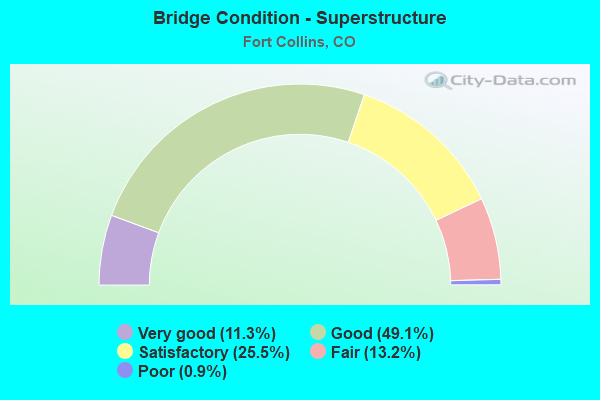
- Bridge Condition - Superstructure
- 11.3%Very good
- 49.1%Good
- 25.5%Satisfactory
- 13.2%Fair
- 0.9%Poor
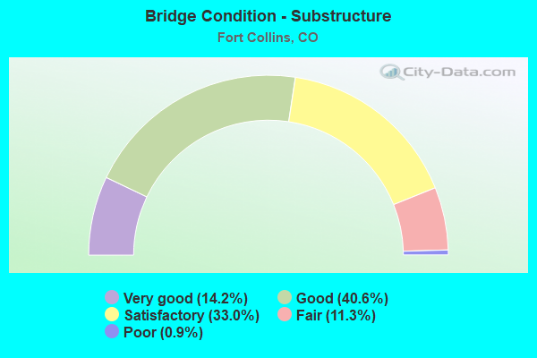
- Bridge Condition - Substructure
- 14.2%Very good
- 40.6%Good
- 33.0%Satisfactory
- 11.3%Fair
- 0.9%Poor
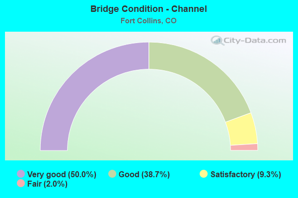
- Bridge Condition - Channel
- 50.0%Very good
- 38.7%Good
- 9.3%Satisfactory
- 2.0%Fair
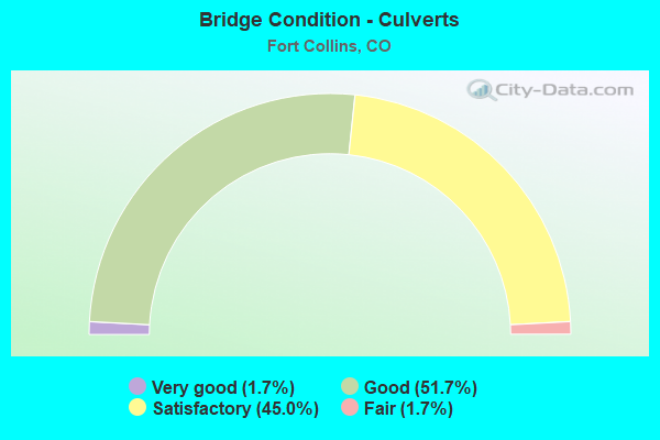
- Bridge Condition - Culverts
- 1.7%Very good
- 51.7%Good
- 45.0%Satisfactory
- 1.7%Fair
Find on map >> Show street view
Structure Number: C-15-AJ, Location: 7.5 MI E OF ESTES PARK (Lat: 40.411056, Lng: -105.400344), Route carried "on" structure: US 34A, Year Built: 1978, Status: Open, Structure Length: 0.64m (2.10ft), Average Daily Traffic: 5,800 (year 2020), Truck Traffic: 2%, Average Future Daily Traffic: 7,250 (year 2040), Features Intersected: DRAW, Facility Carried by Structure: SH 34 ML
Minimum Vertical Clearance: 30+ m (98+ ft), Kilometerpoint: 113.998, Lanes on structure: 2, Base Highway Network: Yes, Owner: State Highway Agency, Approaching Roadway Width: 9.8m (32.2ft), Material/Design: Concrete, Design/Construction: Culvert, Number Of Spans In Main Unit: 2, Length of Maximum Span: 3.0m (9.8ft), Out-to-Out Width: 14.0m (45.9ft)
Condition: Channel: Good, Culverts: Satisfactory, Operating Rating: 36.3 metric tons, Method Used To Determine Operating Rating: Field evaluation and documented engineering judgment, Inventory Rating: 32.7 metric tons, Method Used To Determine Inventory Rating: Field evaluation and documented engineering judgment, Structural Evaluation: Equal to present minimum criteria, Waterway Adequacy: Equal to present minimum criteria, Approach Roadway Alignment: Equal to present desirable criteria, Designated Inspection Frequency: Every 24 months, Inspection Date: September 2021
Find on map >> Show street view
Structure Number: C-15-AO, Location: _ (Lat: 40.426819, Lng: -105.295836), Route carried "on" structure: US 34A, Year Built: 2018, Status: Open, Structure Length: 7.78m (25.52ft), Average Daily Traffic: 4,900 (year 2020), Truck Traffic: 4%, Average Future Daily Traffic: 5,684 (year 2040), Design Load: HL 93, Features Intersected: BIG THOMPSON RIVER, Facility Carried by Structure: US 34 ML
Minimum Vertical Clearance: 30+ m (98+ ft), Kilometerpoint: 125.175, Lanes on structure: 2, Base Highway Network: Yes, Owner: State Highway Agency, Approaching Roadway Width: 11.0m (36.1ft), Skew: 1 degrees, Material/Design: Steel continuous, Design/Construction: Stringer/Multi-beam, Number Of Spans In Main Unit: 3, Length of Maximum Span: 35.0m (114.8ft), Curb-To-Curb Width: 11.0m (36.1ft), Out-to-Out Width: 11.9m (39.0ft)
Condition: Deck: Very good, Superstructure: Very good, Substructure: Very good, Channel: Very good, Operating Rating: 48.6 metric tons, Method Used To Determine Operating Rating: Load and Resistance Factor Rating (LRFR) rating reported by rating factor(RF) method using HL-93 loadings, Inventory Rating: 35.6 metric tons, Method Used To Determine Inventory Rating: Load and Resistance Factor Rating (LRFR) rating reported by rating factor(RF) method using HL-93 loadings, Structural Evaluation: Equal to present desirable criteria, Deck Geometry: Somewhat better than minimum adequacy, Waterway Adequacy: Equal to present desirable criteria, Approach Roadway Alignment: Equal to present desirable criteria, Designated Inspection Frequency: Every 24 months, Inspection Date: September 2021, Deck Structure Type: Concrete Cast-file-Place, Wearing Surface/Protective System: Wearing Surface: Bituminous, Membrane: Built-up, Deck Protection: Epoxy Coated Reinforcing
Find on map >> Show street view
Structure Number: C-15-AP, Location: _ (Lat: 40.426497, Lng: -105.293831), Route carried "on" structure: US 34A, Year Built: 2018, Status: Open, Structure Length: 11.58m (37.99ft), Average Daily Traffic: 4,900 (year 2020), Truck Traffic: 4%, Average Future Daily Traffic: 5,684 (year 2040), Design Load: HL 93, Features Intersected: BIG THOMPSON RIVER, Facility Carried by Structure: US 34 ML
Minimum Vertical Clearance: 30.48m (100.00ft), Kilometerpoint: 125.175, Lanes on structure: 2, Base Highway Network: Yes, Owner: State Highway Agency, Approaching Roadway Width: 11.9m (39.0ft), Skew: 1 degrees, Material/Design: Steel continuous, Design/Construction: Stringer/Multi-beam, Number Of Spans In Main Unit: 3, Length of Maximum Span: 39.4m (129.3ft), Curb or Sidewalk Widths: Left: 0.5m (1.6ft), Right: 0.5m (1.6ft), Curb-To-Curb Width: 11.9m (39.0ft), Out-to-Out Width: 11.9m (39.0ft)
Condition: Deck: Good, Superstructure: Very good, Substructure: Good, Channel: Very good, Operating Rating: 42.1 metric tons, Method Used To Determine Operating Rating: Load and Resistance Factor Rating (LRFR) rating reported by rating factor(RF) method using HL-93 loadings, Inventory Rating: 32.4 metric tons, Method Used To Determine Inventory Rating: Load and Resistance Factor Rating (LRFR) rating reported by rating factor(RF) method using HL-93 loadings, Structural Evaluation: Better than present minimum criteria, Deck Geometry: Somewhat better than minimum adequacy, Waterway Adequacy: Equal to present desirable criteria, Approach Roadway Alignment: Equal to present desirable criteria, Designated Inspection Frequency: Every 24 months, Inspection Date: September 2021, Deck Structure Type: Concrete Cast-file-Place, Wearing Surface/Protective System: Wearing Surface: Bituminous, Membrane: Built-up, Deck Protection: Epoxy Coated Reinforcing
Find on map >> Show street view
Structure Number: C-16-CJ, Location: 0.1 MI E OF Lemay Ave. (Lat: 40.479983, Lng: -105.057242), Route carried "on" structure: State highway 392A, Year Built: 2009, Status: Open, Structure Length: 0.79m (2.59ft), Average Daily Traffic: 11,000 (year 2020), Truck Traffic: 3%, Average Future Daily Traffic: 13,750 (year 2040), Features Intersected: West Fork Fossil Creek, Facility Carried by Structure: SH 392 ML
Minimum Vertical Clearance: 30+ m (98+ ft), Kilometerpoint: 1.709, Lanes on structure: 2, Owner: State Highway Agency, Approaching Roadway Width: 20.1m (65.9ft), Skew: 1 degrees, Material/Design: Concrete, Design/Construction: Culvert, Number Of Spans In Main Unit: 1, Length of Maximum Span: 7.9m (25.9ft), Curb or Sidewalk Widths: Left: 2.9m (9.5ft), Right: 0.0m, Curb-To-Curb Width: 20.3m (66.6ft), Out-to-Out Width: 23.9m (78.4ft)
Condition: Channel: Very good, Culverts: Satisfactory, Operating Rating: 36.3 metric tons, Method Used To Determine Operating Rating: Field evaluation and documented engineering judgment, Inventory Rating: 32.7 metric tons, Method Used To Determine Inventory Rating: Field evaluation and documented engineering judgment, Structural Evaluation: Equal to present minimum criteria, Deck Geometry: Superior to present desirable criteria, Waterway Adequacy: Equal to present desirable criteria, Approach Roadway Alignment: Equal to present desirable criteria, Designated Inspection Frequency: Every 24 months, Inspection Date: November 2021
Find on map >> Show street view
Structure Number: C-17-EE, Location: 1.1 MI SO OF JCT SH 402 (Lat: 40.363533, Lng: -104.985850), Route carried "on" structure: Interstate 25A, Year Built: 1962, Status: Open, Structure Length: 3.04m (9.97ft), Average Daily Traffic: 36,500 (year 2020), Truck Traffic: 10%, Average Future Daily Traffic: 54,020 (year 2040), Design Load: HS 20, Features Intersected: COUNTY ROAD 16, Facility Carried by Structure: I 25 ML SBND
Minimum Vertical Clearance: 30+ m (98+ ft), Kilometerpoint: 408.772, Lanes on structure: 2, Lanes under structure: 2, Base Highway Network: Yes, Owner: State Highway Agency, Approaching Roadway Width: 11.6m (38.1ft), Skew: 12 degrees, Material/Design: Concrete, Design/Construction: Tee Beam, Number Of Spans In Main Unit: 3, Length of Maximum Span: 9.8m (32.2ft), Curb-To-Curb Width: 11.6m (38.1ft), Out-to-Out Width: 12.8m (42.0ft)
Condition: Deck: Satisfactory, Superstructure: Satisfactory, Substructure: Satisfactory, Operating Rating: 52.8 metric tons, Method Used To Determine Operating Rating: Load Factor (LF), Inventory Rating: 31.7 metric tons, Method Used To Determine Inventory Rating: Load Factor (LF), Structural Evaluation: Equal to present minimum criteria, Deck Geometry: Equal to present minimum criteria, Underclear: High priority of corrective action, Approach Roadway Alignment: Equal to present desirable criteria, Designated Inspection Frequency: Every 24 months, Inspection Date: June 2021, Deck Structure Type: Concrete Cast-file-Place, Wearing Surface/Protective System: Wearing Surface: Other, Membrane: Other
Find on map >> Show street view
Structure Number: C-17-EN, Location: 1.5 MI NO OF JCT SH 402 (Lat: 40.399578, Lng: -104.993842), Route carried "on" structure: County highway , Year Built: 2021, Status: Open, Structure Length: 7.10m (23.29ft), Average Daily Traffic: 581 (year 2008), Truck Traffic: 11%, Average Future Daily Traffic: 1,104 (year 2028), Design Load: HS 20, Features Intersected: I 25 ML, Facility Carried by Structure: COUNTY ROAD 20E
Minimum Vertical Clearance: 30.18m (99.02ft), Kilometerpoint: 0.000, Lanes on structure: 3, Lanes under structure: 5, Owner: State Highway Agency, Approaching Roadway Width: 14.6m (47.9ft), Material/Design: Prestressed concrete continuous, Design/Construction: Stringer/Multi-beam, Number Of Spans In Main Unit: 2, Length of Maximum Span: 35.1m (115.2ft), Curb-To-Curb Width: 14.6m (47.9ft), Out-to-Out Width: 15.5m (50.9ft)
Condition: Deck: Very good, Superstructure: Very good, Substructure: Very good, Operating Rating: 51.8 metric tons, Method Used To Determine Operating Rating: Load and Resistance Factor Rating (LRFR) rating reported by rating factor(RF) method using HL-93 loadings, Inventory Rating: 32.4 metric tons, Method Used To Determine Inventory Rating: Load and Resistance Factor Rating (LRFR) rating reported by rating factor(RF) method using HL-93 loadings, Structural Evaluation: Equal to present desirable criteria, Deck Geometry: Somewhat better than minimum adequacy, Underclear: Equal to present minimum criteria, Approach Roadway Alignment: Somewhat better than minimum adequacy, Designated Inspection Frequency: Every 24 months, Inspection Date: June 2021, Deck Structure Type: Concrete Precast Panels, Wearing Surface/Protective System: Wearing Surface: Bituminous, Membrane: Preformed Fabric, Deck Protection: Epoxy Coated Reinforcing
Find on map >> Show street view
Structure Number: C-17-FK, Location: I-25/WINDSOR INTERCHANGE (Lat: 40.479289, Lng: -104.992217), Route carried "on" structure: State highway 392A, Year Built: 2012, Status: Open, Structure Length: 8.29m (27.20ft), Average Daily Traffic: 15,000 (year 2020), Truck Traffic: 3%, Average Future Daily Traffic: 19,650 (year 2040), Design Load: HL 93, Features Intersected: I 25 ML, Facility Carried by Structure: SH 392 ML
Minimum Vertical Clearance: 30+ m (98+ ft), Kilometerpoint: 7.509, Lanes on structure: 6, Lanes under structure: 6, Base Highway Network: Yes, Owner: State Highway Agency, Approaching Roadway Width: 31.7m (104.0ft), Skew: 10 degrees, Material/Design: Prestressed concrete continuous, Design/Construction: Box Beam or Girders - Single/Spread, Number Of Spans In Main Unit: 2, Length of Maximum Span: 43.7m (143.4ft), Curb or Sidewalk Widths: Left: 2.0m (6.6ft), Right: 2.0m (6.6ft), Curb-To-Curb Width: 31.7m (104.0ft), Out-to-Out Width: 36.6m (120.1ft)
Condition: Deck: Very good, Superstructure: Good, Substructure: Good, Operating Rating: 84.2 metric tons, Method Used To Determine Operating Rating: Load and Resistance Factor Rating (LRFR) rating reported by rating factor(RF) method using HL-93 loadings, Inventory Rating: 32.4 metric tons, Method Used To Determine Inventory Rating: Load and Resistance Factor Rating (LRFR) rating reported by rating factor(RF) method using HL-93 loadings, Structural Evaluation: Better than present minimum criteria, Deck Geometry: Superior to present desirable criteria, Underclear: High priority of corrective action, Approach Roadway Alignment: Equal to present desirable criteria, Designated Inspection Frequency: Every 24 months, Inspection Date: June 2021, Deck Structure Type: Concrete Precast Panels, Wearing Surface/Protective System: Wearing Surface: Bituminous, Membrane: Built-up, Deck Protection: Epoxy Coated Reinforcing
Find on map >> Show street view
Structure Number: C-17-FL, Location: 1400 ft.W.of C-17-FK (Lat: 40.488039, Lng: -105.003961), Route carried "on" structure: State highway 392A, Year Built: 2015, Status: Open, Structure Length: 1.00m (3.28ft), Average Daily Traffic: 15,000 (year 2020), Truck Traffic: 3%, Average Future Daily Traffic: 19,650 (year 2040), Design Load: HL 93, Features Intersected: DRAW, Facility Carried by Structure: SH 392 ML
Minimum Vertical Clearance: 30+ m (98+ ft), Kilometerpoint: 7.691, Lanes on structure: 2, Base Highway Network: Yes, Owner: State Highway Agency, Approaching Roadway Width: 30.5m (100.1ft), Material/Design: Concrete, Design/Construction: Culvert, Number Of Spans In Main Unit: 2, Length of Maximum Span: 4.9m (16.1ft), Curb-To-Curb Width: 20.2m (66.3ft), Out-to-Out Width: 24.6m (80.7ft)
Condition: Channel: Very good, Culverts: Good, Operating Rating: 91.7 metric tons, Method Used To Determine Operating Rating: Load and Resistance Factor Rating (LRFR) rating reported by rating factor(RF) method using HL-93 loadings, Inventory Rating: 34.0 metric tons, Method Used To Determine Inventory Rating: Load and Resistance Factor Rating (LRFR) rating reported by rating factor(RF) method using HL-93 loadings, Structural Evaluation: Better than present minimum criteria, Deck Geometry: Superior to present desirable criteria, Waterway Adequacy: Equal to present desirable criteria, Approach Roadway Alignment: Equal to present desirable criteria, Designated Inspection Frequency: Every 24 months, Inspection Date: June 2021
Find on map >> Show street view
Structure Number: C-17-GJ, Location: 1 MI N OF LOVELAND INTRCH (Lat: 40.422861, Lng: -104.992711), Route carried "on" structure: Interstate 25A, Year Built: 2020, Status: Open, Structure Length: 7.33m (24.05ft), Average Daily Traffic: 76,000 (year 2020), Truck Traffic: 10%, Average Future Daily Traffic: 116,964 (year 2042), Design Load: HL 93, Features Intersected: UPRR, Facility Carried by Structure: I-25 ML
Minimum Vertical Clearance: 30+ m (98+ ft), Kilometerpoint: 0.000, Lanes on structure: 4, Base Highway Network: Yes, Owner: State Highway Agency, Approaching Roadway Width: 22.3m (73.2ft), Skew: 4 degrees, Material/Design: Prestressed concrete continuous, Design/Construction: Stringer/Multi-beam, Number Of Spans In Main Unit: 2, Length of Maximum Span: 43.2m (141.7ft), Curb-To-Curb Width: 22.3m (73.2ft), Out-to-Out Width: 23.2m (76.1ft)
Condition: Deck: Very good, Superstructure: Good, Substructure: Very good, Operating Rating: 58.3 metric tons, Method Used To Determine Operating Rating: Load and Resistance Factor Rating (LRFR) rating reported by rating factor(RF) method using HL-93 loadings, Inventory Rating: 45.4 metric tons, Method Used To Determine Inventory Rating: Load and Resistance Factor Rating (LRFR) rating reported by rating factor(RF) method using HL-93 loadings, Structural Evaluation: Better than present minimum criteria, Deck Geometry: Superior to present desirable criteria, Underclear: Superior to present desirable criteria, Approach Roadway Alignment: Equal to present desirable criteria, Designated Inspection Frequency: Every 24 months, Inspection Date: June 2021, Deck Structure Type: Concrete Precast Panels, Wearing Surface/Protective System: Wearing Surface: Bituminous, Membrane: Preformed Fabric, Deck Protection: Epoxy Coated Reinforcing
Find on map >> Show street view
Structure Number: FCBDWK-0.2-LNDS, Location: 50 Ft N of Troutman Pkwy (Lat: 40.529667, Lng: -105.070972), Route carried "on" structure: City street , Year Built: 1982, Status: Open, Structure Length: 0.67m (2.20ft), Average Daily Traffic: 11,653 (year 2020), Truck Traffic: 7%, Average Future Daily Traffic: 14,566 (year 2040), Design Load: HS 20, Features Intersected: Larimer Co. Canal No. 2, Facility Carried by Structure: Boardwalk Drive
Minimum Vertical Clearance: 30+ m (98+ ft), Kilometerpoint: 2.237, Lanes on structure: 2, Owner: City or Municipal Highway Agency, Approaching Roadway Width: 13.4m (44.0ft), Skew: 2 degrees, Material/Design: Concrete, Design/Construction: Culvert, Number Of Spans In Main Unit: 1, Length of Maximum Span: 6.7m (22.0ft), Curb or Sidewalk Widths: Left: 2.0m (6.6ft), Right: 2.3m (7.5ft), Curb-To-Curb Width: 13.5m (44.3ft), Out-to-Out Width: 18.4m (60.4ft)
Condition: Channel: Good, Culverts: Satisfactory, Inventory Rating: 84.5 metric tons, Method Used To Determine Inventory Rating: Load Factor (LF), Structural Evaluation: Equal to present minimum criteria, Deck Geometry: Superior to present desirable criteria, Waterway Adequacy: Equal to present desirable criteria, Approach Roadway Alignment: Equal to present desirable criteria, Designated Inspection Frequency: Every 24 months, Inspection Date: March 2021
Find on map >> Show street view
Structure Number: FCBRYN-0.0-WSTV, Location: 75 Ft N of Westview Ave (Lat: 40.580556, Lng: -105.105500), Route carried "on" structure: City street , Year Built: 1960, Year Reconstructed: 2017, Status: Open, Structure Length: 0.78m (2.56ft), Average Daily Traffic: 581 (year 2021), Truck Traffic: 5%, Average Future Daily Traffic: 726 (year 2041), Features Intersected: Larimer Co. Canal No. 2, Facility Carried by Structure: Bryan Avenue
Minimum Vertical Clearance: 30+ m (98+ ft), Kilometerpoint: 0.084, Lanes on structure: 2, Owner: City or Municipal Highway Agency, Approaching Roadway Width: 8.1m (26.6ft), Skew: 3 degrees, Material/Design: Prestressed concrete, Design/Construction: Tee Beam, Number Of Spans In Main Unit: 1, Length of Maximum Span: 7.2m (23.6ft), Curb or Sidewalk Widths: Left: 1.4m (4.6ft), Right: 1.0m (3.3ft), Curb-To-Curb Width: 10.5m (34.4ft), Out-to-Out Width: 10.7m (35.1ft)
Condition: Deck: Satisfactory, Superstructure: Satisfactory, Substructure: Satisfactory, Channel: Good, Operating Rating: 36.3 metric tons, Method Used To Determine Operating Rating: Field evaluation and documented engineering judgment, Inventory Rating: 32.7 metric tons, Method Used To Determine Inventory Rating: Field evaluation and documented engineering judgment, Structural Evaluation: Equal to present minimum criteria, Deck Geometry: Equal to present minimum criteria, Waterway Adequacy: Equal to present desirable criteria, Approach Roadway Alignment: Equal to present desirable criteria, Designated Inspection Frequency: Every 24 months, Inspection Date: April 2021, Deck Structure Type: Other, Wearing Surface/Protective System: Wearing Surface: Bituminous
Find on map >> Show street view
Structure Number: FCBRYN-02-MULBA, Location: 0.2 Mi N of Mulberry St (Lat: 40.583611, Lng: -105.105278), Route carried "on" structure: City street , Year Built: 2015, Status: Open, Structure Length: 0.94m (3.08ft), Average Daily Traffic: 1,262 (year 2021), Truck Traffic: 6%, Average Future Daily Traffic: 1,578 (year 2041), Design Load: HL 93, Features Intersected: Larimer Co Canal No. 2, Facility Carried by Structure: Bryan Avenue
Minimum Vertical Clearance: 30+ m (98+ ft), Kilometerpoint: 0.650, Lanes on structure: 2, Owner: City or Municipal Highway Agency, Approaching Roadway Width: 7.3m (24.0ft), Skew: 3 degrees, Material/Design: Concrete, Design/Construction: Culvert, Number Of Spans In Main Unit: 1, Length of Maximum Span: 9.4m (30.8ft), Curb or Sidewalk Widths: Left: 2.0m (6.6ft), Right: 2.0m (6.6ft), Curb-To-Curb Width: 8.2m (26.9ft), Out-to-Out Width: 20.1m (65.9ft)
Condition: Channel: Very good, Culverts: Good, Operating Rating: 36.3 metric tons, Method Used To Determine Operating Rating: Load Factor (LF), Inventory Rating: 32.7 metric tons, Method Used To Determine Inventory Rating: Load Factor (LF), Structural Evaluation: Better than present minimum criteria, Deck Geometry: Meets minimum limits, Waterway Adequacy: Equal to present desirable criteria, Approach Roadway Alignment: Equal to present desirable criteria, Designated Inspection Frequency: Every 24 months, Inspection Date: May 2021
Find on map >> Show street view
Structure Number: FCBTCK-TMB, Location: 0.1 Mi W of CR 11 (Lat: 40.515006, Lng: -105.039747), Route carried "on" structure: City street _, Year Built: 2000, Status: Open, Structure Length: 0.62m (2.03ft), Average Daily Traffic: 2,725 (year 2019), Average Future Daily Traffic: 5,423 (year 2039), Features Intersected: Unknown Drainage, Facility Carried by Structure: Battlecreek Drive
Minimum Vertical Clearance: 30+ m (98+ ft), Kilometerpoint: 0.000, Lanes on structure: 3, Owner: City or Municipal Highway Agency, Approaching Roadway Width: 14.8m (48.6ft), Material/Design: Concrete, Design/Construction: Culvert, Number Of Spans In Main Unit: 4, Length of Maximum Span: 1.2m (3.9ft), Curb or Sidewalk Widths: Left: 1.5m (4.9ft), Right: 1.5m (4.9ft), Out-to-Out Width: 34.2m (112.2ft)
Condition: Channel: Very good, Culverts: Satisfactory, Operating Rating: 36.3 metric tons, Method Used To Determine Operating Rating: Field evaluation and documented engineering judgment, Inventory Rating: 32.7 metric tons, Method Used To Determine Inventory Rating: Field evaluation and documented engineering judgment, Structural Evaluation: Equal to present minimum criteria, Waterway Adequacy: Equal to present desirable criteria, Approach Roadway Alignment: Equal to present desirable criteria, Designated Inspection Frequency: Every 24 months, Inspection Date: December 2021
Find on map >> Show street view
Structure Number: FCCHAS-0.1-ANSA, Location: .25 Mi SW Drake ,Ziegler (Lat: 40.547139, Lng: -105.024500), Route carried "on" structure: City street , Year Built: 2008, Status: Open, Structure Length: 1.15m (3.77ft), Average Daily Traffic: 131 (year 2020), Truck Traffic: 24%, Average Future Daily Traffic: 164 (year 2040), Design Load: HS 20, Features Intersected: Fossil Ck Resv Inlet, Facility Carried by Structure: Chase Drive
Minimum Vertical Clearance: 30+ m (98+ ft), Kilometerpoint: 0.552, Lanes on structure: 2, Owner: City or Municipal Highway Agency, Approaching Roadway Width: 11.0m (36.1ft), Material/Design: Concrete, Design/Construction: Culvert, Number Of Spans In Main Unit: 3, Length of Maximum Span: 3.7m (12.1ft), Curb or Sidewalk Widths: Left: 2.4m (7.9ft), Right: 4.1m (13.5ft), Curb-To-Curb Width: 11.0m (36.1ft), Out-to-Out Width: 18.4m (60.4ft)
Condition: Channel: Very good, Culverts: Very good, Operating Rating: 36.3 metric tons, Method Used To Determine Operating Rating: Field evaluation and documented engineering judgment, Inventory Rating: 32.7 metric tons, Method Used To Determine Inventory Rating: Field evaluation and documented engineering judgment, Structural Evaluation: Equal to present desirable criteria, Deck Geometry: Equal to present desirable criteria, Waterway Adequacy: Equal to present desirable criteria, Approach Roadway Alignment: Equal to present desirable criteria, Designated Inspection Frequency: Every 24 months, Inspection Date: June 2021
Find on map >> Show street view
Structure Number: FCCORB-0.1-SDCK, Location: 100 Ft N of Saddle Crk Dr (Lat: 40.511667, Lng: -105.024167), Route carried "on" structure: City street , Year Built: 2001, Status: Open, Structure Length: 0.68m (2.23ft), Average Daily Traffic: 1,320 (year 2020), Truck Traffic: 11%, Average Future Daily Traffic: 1,650 (year 2040), Design Load: HS 20, Features Intersected: McClellands Channel, Facility Carried by Structure: Corbett Drive
Minimum Vertical Clearance: 30+ m (98+ ft), Kilometerpoint: 0.233, Lanes on structure: 2, Owner: City or Municipal Highway Agency, Approaching Roadway Width: 15.2m (49.9ft), Skew: 1 degrees, Material/Design: Concrete, Design/Construction: Frame, Number Of Spans In Main Unit: 1, Length of Maximum Span: 6.2m (20.3ft), Curb or Sidewalk Widths: Left: 2.3m (7.5ft), Right: 2.3m (7.5ft), Curb-To-Curb Width: 15.3m (50.2ft), Out-to-Out Width: 21.0m (68.9ft)
Condition: Deck: Satisfactory, Superstructure: Satisfactory, Substructure: Satisfactory, Channel: Very good, Operating Rating: 36.3 metric tons, Method Used To Determine Operating Rating: Field evaluation and documented engineering judgment, Inventory Rating: 32.7 metric tons, Method Used To Determine Inventory Rating: Field evaluation and documented engineering judgment, Structural Evaluation: Equal to present minimum criteria, Deck Geometry: Superior to present desirable criteria, Waterway Adequacy: Equal to present desirable criteria, Approach Roadway Alignment: Equal to present desirable criteria, Designated Inspection Frequency: Every 24 months, Inspection Date: June 2021, Deck Structure Type: Other, Wearing Surface/Protective System: Wearing Surface: Bituminous
Find on map >> Show street view
Structure Number: FCCRST-0.1-BRYN, Location: 0.1 Mi E of Bryan Avenue (Lat: 40.579417, Lng: -105.103611), Route carried "on" structure: City street , Year Built: 1955, Year Reconstructed: 1970, Status: Open, Structure Length: 0.69m (2.26ft), Average Daily Traffic: 969 (year 2021), Truck Traffic: 3%, Average Future Daily Traffic: 1,211 (year 2041), Features Intersected: Larimer Co. Canal No. 2, Facility Carried by Structure: Crestmore Court
Minimum Vertical Clearance: 30+ m (98+ ft), Kilometerpoint: 0.924, Lanes on structure: 2, Owner: City or Municipal Highway Agency, Approaching Roadway Width: 11.0m (36.1ft), Material/Design: Concrete, Design/Construction: Slab, Number Of Spans In Main Unit: 1, Length of Maximum Span: 6.2m (20.3ft), Curb or Sidewalk Widths: Left: 0.7m (2.3ft), Right: 0.7m (2.3ft), Curb-To-Curb Width: 6.7m (22.0ft), Out-to-Out Width: 8.4m (27.6ft)
Condition: Deck: Good, Superstructure: Good, Substructure: Satisfactory, Channel: Good, Operating Rating: 36.3 metric tons, Method Used To Determine Operating Rating: Field evaluation and documented engineering judgment, Inventory Rating: 32.7 metric tons, Method Used To Determine Inventory Rating: Field evaluation and documented engineering judgment, Structural Evaluation: Equal to present minimum criteria, Deck Geometry: Meets minimum limits, Waterway Adequacy: Equal to present desirable criteria, Approach Roadway Alignment: Somewhat better than minimum adequacy, Designated Inspection Frequency: Every 24 months, Inspection Date: April 2021, Deck Structure Type: Concrete Cast-file-Place, Wearing Surface/Protective System: Wearing Surface: Bituminous
Find on map >> Show street view
Structure Number: FCCTRE-0.1-BAY, Location: .1Mi S of Bay Dr. (Lat: 40.564139, Lng: -105.083528), Route carried "on" structure: City street , Year Built: 2010, Status: Open, Structure Length: 1.45m (4.76ft), Average Daily Traffic: 8,503 (year 2020), Truck Traffic: 8%, Average Future Daily Traffic: 10,629 (year 2040), Features Intersected: Spring Creek, Facility Carried by Structure: Centre Ave
Minimum Vertical Clearance: 30+ m (98+ ft), Kilometerpoint: 1.624, Lanes on structure: 2, Owner: City or Municipal Highway Agency, Approaching Roadway Width: 15.2m (49.9ft), Skew: 3 degrees, Material/Design: Concrete, Design/Construction: Frame, Number Of Spans In Main Unit: 2, Length of Maximum Span: 6.9m (22.6ft), Curb or Sidewalk Widths: Left: 1.5m (4.9ft), Right: 1.5m (4.9ft), Curb-To-Curb Width: 15.3m (50.2ft), Out-to-Out Width: 22.3m (73.2ft)
Condition: Deck: Good, Superstructure: Good, Substructure: Good, Channel: Very good, Operating Rating: 36.3 metric tons, Method Used To Determine Operating Rating: Field evaluation and documented engineering judgment, Inventory Rating: 32.7 metric tons, Method Used To Determine Inventory Rating: Field evaluation and documented engineering judgment, Structural Evaluation: Better than present minimum criteria, Deck Geometry: Superior to present desirable criteria, Waterway Adequacy: Equal to present desirable criteria, Approach Roadway Alignment: Equal to present desirable criteria, Designated Inspection Frequency: Every 24 months, Inspection Date: June 2021, Deck Structure Type: Concrete Cast-file-Place, Wearing Surface/Protective System: Wearing Surface: Bituminous
Find on map >> Show street view
Structure Number: FCCTRE-0.1-WTGN, Location: 0.1 M E of Worthington St (Lat: 40.556750, Lng: -105.088889), Route carried "on" structure: City street , Year Built: 1989, Status: Open, Structure Length: 0.83m (2.72ft), Average Daily Traffic: 6,040 (year 2020), Truck Traffic: 7%, Average Future Daily Traffic: 7,550 (year 2040), Design Load: HS 20, Features Intersected: New Mercer Canal, Facility Carried by Structure: Centre Street
Minimum Vertical Clearance: 30+ m (98+ ft), Kilometerpoint: 0.641, Lanes on structure: 3, Owner: City or Municipal Highway Agency, Approaching Roadway Width: 15.2m (49.9ft), Skew: 4 degrees, Material/Design: Concrete, Design/Construction: Culvert, Number Of Spans In Main Unit: 1, Length of Maximum Span: 8.3m (27.2ft), Curb or Sidewalk Widths: Left: 1.3m (4.3ft), Right: 1.4m (4.6ft), Curb-To-Curb Width: 15.2m (49.9ft), Out-to-Out Width: 18.5m (60.7ft)
Condition: Channel: Good, Culverts: Good, Operating Rating: 84.9 metric tons, Method Used To Determine Operating Rating: Load Factor (LF), Inventory Rating: 51.0 metric tons, Method Used To Determine Inventory Rating: Load Factor (LF), Structural Evaluation: Better than present minimum criteria, Deck Geometry: Equal to present minimum criteria, Waterway Adequacy: Equal to present desirable criteria, Approach Roadway Alignment: Equal to present desirable criteria, Designated Inspection Frequency: Every 24 months, Inspection Date: April 2021
Find on map >> Show street view
Structure Number: FCDRK-0.0-CONST, Location: 0.0 Mi E of Hanover Dr (Lat: 40.552889, Lng: -105.107611), Route carried "on" structure: City street , Year Built: 1997, Status: Open, Structure Length: 2.61m (8.56ft), Average Daily Traffic: 22,737 (year 2020), Truck Traffic: 7%, Average Future Daily Traffic: 28,421 (year 2040), Design Load: HS 20, Features Intersected: Spring Creek, Facility Carried by Structure: Drake Road
Minimum Vertical Clearance: 30+ m (98+ ft), Kilometerpoint: 2.245, Lanes on structure: 4, Owner: City or Municipal Highway Agency, Approaching Roadway Width: 17.7m (58.1ft), Skew: 25 degrees, Material/Design: Prestressed concrete, Design/Construction: Box Beam or Girders - Multiple, Number Of Spans In Main Unit: 2, Length of Maximum Span: 11.1m (36.4ft), Curb or Sidewalk Widths: Left: 2.2m (7.2ft), Right: 2.2m (7.2ft), Curb-To-Curb Width: 17.7m (58.1ft), Out-to-Out Width: 28.0m (91.9ft)
Condition: Deck: Satisfactory, Superstructure: Satisfactory, Substructure: Satisfactory, Channel: Very good, Operating Rating: 72.5 metric tons, Method Used To Determine Operating Rating: Load Factor (LF), Inventory Rating: 42.8 metric tons, Method Used To Determine Inventory Rating: Load Factor (LF), Structural Evaluation: Equal to present minimum criteria, Deck Geometry: Somewhat better than minimum adequacy, Waterway Adequacy: Equal to present minimum criteria, Approach Roadway Alignment: Equal to present desirable criteria, Designated Inspection Frequency: Every 24 months, Inspection Date: June 2021, Deck Structure Type: Concrete Cast-file-Place, Wearing Surface/Protective System: Wearing Surface: Monolithic Concrete, Deck Protection: Epoxy Coated Reinforcing
Find on map >> Show street view
Structure Number: FCDRK-0.1-MDWLK, Location: 0.1 Mi E of Meadowlark Av (Lat: 40.552750, Lng: -105.084472), Route carried "on" structure: City street , Year Built: 1935, Year Reconstructed: 1993, Status: Open, Structure Length: 0.91m (2.99ft), Average Daily Traffic: 32,704 (year 2021), Truck Traffic: 4%, Average Future Daily Traffic: 40,880 (year 2041), Features Intersected: Larimer Co. Canal No. 2, Facility Carried by Structure: Drake Road
Minimum Vertical Clearance: 30+ m (98+ ft), Kilometerpoint: 4.216, Lanes on structure: 5, Owner: City or Municipal Highway Agency, Approaching Roadway Width: 21.3m (69.9ft), Skew: 5 degrees, Material/Design: Prestressed concrete, Design/Construction: Tee Beam, Number Of Spans In Main Unit: 1, Length of Maximum Span: 7.7m (25.3ft), Curb or Sidewalk Widths: Left: 2.4m (7.9ft), Right: 3.0m (9.8ft), Curb-To-Curb Width: 21.5m (70.5ft), Out-to-Out Width: 27.7m (90.9ft)
Condition: Deck: Fair, Superstructure: Fair, Substructure: Fair, Channel: Good, Operating Rating: 32.7 metric tons, Method Used To Determine Operating Rating: Field evaluation and documented engineering judgment, Inventory Rating: 24.5 metric tons, Method Used To Determine Inventory Rating: Field evaluation and documented engineering judgment, Structural Evaluation: Somewhat better than minimum adequacy, Deck Geometry: Somewhat better than minimum adequacy, Waterway Adequacy: Equal to present desirable criteria, Approach Roadway Alignment: Equal to present desirable criteria, Designated Inspection Frequency: Every 24 months, Inspection Date: March 2021, Deck Structure Type: Other, Wearing Surface/Protective System: Wearing Surface: Bituminous
Find on map >> Show street view
Structure Number: FCELIZ-0.1-BRYN, Location: 200 Ft E of Bryan Ave (Lat: 40.574722, Lng: -105.104472), Route carried "on" structure: City street , Year Built: 1960, Status: Open, Structure Length: 0.67m (2.20ft), Average Daily Traffic: 17,952 (year 2021), Truck Traffic: 3%, Average Future Daily Traffic: 22,440 (year 2041), Features Intersected: Larimer Co. Canal No. 2, Facility Carried by Structure: Elizabeth Street
Minimum Vertical Clearance: 30+ m (98+ ft), Kilometerpoint: 3.117, Lanes on structure: 3, Owner: City or Municipal Highway Agency, Approaching Roadway Width: 18.0m (59.1ft), Material/Design: Prestressed concrete, Design/Construction: Tee Beam, Number Of Spans In Main Unit: 1, Length of Maximum Span: 6.2m (20.3ft), Curb or Sidewalk Widths: Left: 1.7m (5.6ft), Right: 1.5m (4.9ft), Curb-To-Curb Width: 18.0m (59.1ft), Out-to-Out Width: 21.3m (69.9ft)
Condition: Deck: Fair, Superstructure: Fair, Substructure: Fair, Channel: Satisfactory, Operating Rating: 36.3 metric tons, Method Used To Determine Operating Rating: Field evaluation and documented engineering judgment, Inventory Rating: 32.7 metric tons, Method Used To Determine Inventory Rating: Field evaluation and documented engineering judgment, Structural Evaluation: Somewhat better than minimum adequacy, Deck Geometry: Superior to present desirable criteria, Waterway Adequacy: Equal to present desirable criteria, Approach Roadway Alignment: Equal to present desirable criteria, Length Of Structure Improvement: 0.67m (2.20ft), Designated Inspection Frequency: Every 24 months, Inspection Date: April 2021, Bridge Improvement Cost: $175,000, Roadway Improvement Cost: $18,000, Total Project Cost: $193,000 ( Estimate for 2019), Deck Structure Type: Other, Wearing Surface/Protective System: Wearing Surface: Bituminous
Find on map >> Show street view
Structure Number: FCEVINE-0.3-LMY, Location: 0.3 Mi. E. of Lemay (Lat: 40.596167, Lng: -105.051000), Route carried "on" structure: City street , Year Built: 2006, Status: Open, Structure Length: 2.13m (6.99ft), Average Daily Traffic: 9,673 (year 2020), Truck Traffic: 21%, Average Future Daily Traffic: 12,091 (year 2040), Design Load: HS 20, Features Intersected: Dry Creek, Facility Carried by Structure: East Vine Drive
Minimum Vertical Clearance: 30+ m (98+ ft), Kilometerpoint: 2.171, Lanes on structure: 2, Owner: City or Municipal Highway Agency, Approaching Roadway Width: 12.2m (40.0ft), Material/Design: Concrete, Design/Construction: Culvert, Number Of Spans In Main Unit: 6, Length of Maximum Span: 3.0m (9.8ft), Curb-To-Curb Width: 10.4m (34.1ft), Out-to-Out Width: 16.3m (53.5ft)
Condition: Channel: Good, Culverts: Good, Operating Rating: 36.3 metric tons, Method Used To Determine Operating Rating: Field evaluation and documented engineering judgment, Inventory Rating: 32.7 metric tons, Method Used To Determine Inventory Rating: Field evaluation and documented engineering judgment, Structural Evaluation: Better than present minimum criteria, Deck Geometry: Meets minimum limits, Waterway Adequacy: Equal to present desirable criteria, Approach Roadway Alignment: Equal to present desirable criteria, Designated Inspection Frequency: Every 24 months, Inspection Date: June 2021
Find on map >> Show street view
Structure Number: FCFOSCK-0.1-HTH, Location: .1 Mi N Hunt. Hill Dr. (Lat: 40.507222, Lng: -105.066944), Route carried "on" structure: City street , Year Built: 2001, Status: Open, Structure Length: 2.01m (6.59ft), Average Daily Traffic: 1,758 (year 2020), Truck Traffic: 10%, Average Future Daily Traffic: 2,198 (year 2040), Design Load: HS 20, Features Intersected: Fossil Creek, Facility Carried by Structure: Fossil Creek Pkwy.
Minimum Vertical Clearance: 30+ m (98+ ft), Kilometerpoint: 1.284, Lanes on structure: 2, Owner: City or Municipal Highway Agency, Approaching Roadway Width: 12.2m (40.0ft), Skew: 1 degrees, Material/Design: Prestressed concrete, Design/Construction: Box Beam or Girders - Single/Spread, Number Of Spans In Main Unit: 1, Length of Maximum Span: 18.9m (62.0ft), Curb or Sidewalk Widths: Left: 2.3m (7.5ft), Right: 2.3m (7.5ft), Curb-To-Curb Width: 12.2m (40.0ft), Out-to-Out Width: 17.8m (58.4ft)
Condition: Deck: Satisfactory, Superstructure: Good, Substructure: Good, Channel: Good, Operating Rating: 36.3 metric tons, Method Used To Determine Operating Rating: Field evaluation and documented engineering judgment, Inventory Rating: 32.7 metric tons, Method Used To Determine Inventory Rating: Field evaluation and documented engineering judgment, Structural Evaluation: Better than present minimum criteria, Deck Geometry: Better than present minimum criteria, Waterway Adequacy: Equal to present desirable criteria, Approach Roadway Alignment: Equal to present desirable criteria, Designated Inspection Frequency: Every 24 months, Inspection Date: June 2021, Deck Structure Type: Concrete Cast-file-Place, Wearing Surface/Protective System: Wearing Surface: Monolithic Concrete, Deck Protection: Epoxy Coated Reinforcing
Find on map >> Show street view
Structure Number: FCGLR-S-PLM, Location: 0.1 MI N of Plum St (Lat: 40.576528, Lng: -105.112583), Route carried "on" structure: City street , Year Built: 2013, Status: Open, Structure Length: 0.96m (3.15ft), Average Daily Traffic: 513 (year 2021), Truck Traffic: 3%, Average Future Daily Traffic: 641 (year 2041), Design Load: HS 20, Features Intersected: Local Drainage, Facility Carried by Structure: Glenmoor Drive
Minimum Vertical Clearance: 30+ m (98+ ft), Kilometerpoint: 0.304, Lanes on structure: 2, Owner: City or Municipal Highway Agency, Approaching Roadway Width: 11.6m (38.1ft), Material/Design: Concrete, Design/Construction: Culvert, Number Of Spans In Main Unit: 3, Length of Maximum Span: 3.7m (12.1ft), Curb or Sidewalk Widths: Left: 1.2m (3.9ft), Right: 1.2m (3.9ft), Curb-To-Curb Width: 11.6m (38.1ft), Out-to-Out Width: 20.1m (65.9ft)
Condition: Channel: Good, Culverts: Good, Operating Rating: 36.3 metric tons, Method Used To Determine Operating Rating: Field evaluation and documented engineering judgment, Inventory Rating: 32.7 metric tons, Method Used To Determine Inventory Rating: Field evaluation and documented engineering judgment, Structural Evaluation: Better than present minimum criteria, Deck Geometry: Better than present minimum criteria, Waterway Adequacy: Equal to present minimum criteria, Approach Roadway Alignment: Equal to present desirable criteria, Designated Inspection Frequency: Every 24 months, Inspection Date: April 2021
Find on map >> Show street view
Structure Number: FCHRMY-0.7-I25E, Location: .7 MI west of JCT-I25 (Lat: 40.523278, Lng: -105.005528), Route carried "on" structure: City street , Year Built: 2010, Status: Open, Structure Length: 1.49m (4.89ft), Average Daily Traffic: 31,720 (year 2020), Truck Traffic: 2%, Average Future Daily Traffic: 39,650 (year 2040), Design Load: HL 93, Features Intersected: Fossil Crk Res. Inlet, Facility Carried by Structure: EB Harmony Road
Minimum Vertical Clearance: 30+ m (98+ ft), Kilometerpoint: 9.831, Lanes on structure: 3, Owner: City or Municipal Highway Agency, Approaching Roadway Width: 11.0m (36.1ft), Skew: 2 degrees, Material/Design: Prestressed concrete, Design/Construction: Box Beam or Girders - Single/Spread, Number Of Spans In Main Unit: 1, Length of Maximum Span: 13.4m (44.0ft), Curb or Sidewalk Widths: Left: 0.0m, Right: 2.4m (7.9ft), Curb-To-Curb Width: 15.2m (49.9ft), Out-to-Out Width: 19.1m (62.7ft)
Condition: Deck: Very good, Superstructure: Very good, Substructure: Very good, Channel: Good, Operating Rating: 90.7 metric tons, Method Used To Determine Operating Rating: Load and Resistance Factor Rating (LRFR) rating reported by rating factor(RF) method using HL-93 loadings, Inventory Rating: 71.3 metric tons, Method Used To Determine Inventory Rating: Load and Resistance Factor Rating (LRFR) rating reported by rating factor(RF) method using HL-93 loadings, Structural Evaluation: Equal to present desirable criteria, Deck Geometry: Equal to present minimum criteria, Waterway Adequacy: Equal to present desirable criteria, Approach Roadway Alignment: Equal to present desirable criteria, Designated Inspection Frequency: Every 24 months, Inspection Date: May 2021, Deck Structure Type: Concrete Cast-file-Place, Wearing Surface/Protective System: Wearing Surface: Bituminous, Membrane: Built-up, Deck Protection: Epoxy Coated Reinforcing
Find on map >> Show street view
Structure Number: FCHRMYW-0.7-I25, Location: 0.7 Mi. W of Jct I 25 (Lat: 40.523528, Lng: -105.005722), Route carried "on" structure: City street , Year Built: 1973, Status: Open, Structure Length: 0.94m (3.08ft), Average Daily Traffic: 29,665 (year 2020), Truck Traffic: 2%, Average Future Daily Traffic: 37,081 (year 2040), Design Load: HS 20+Mod, Features Intersected: Fossil Crk. Res. Inlet, Facility Carried by Structure: WB Harmony Road
Minimum Vertical Clearance: 30+ m (98+ ft), Kilometerpoint: 9.814, Lanes on structure: 4, Owner: City or Municipal Highway Agency, Approaching Roadway Width: 12.2m (40.0ft), Skew: 2 degrees, Material/Design: Concrete, Design/Construction: Culvert, Number Of Spans In Main Unit: 1, Length of Maximum Span: 9.4m (30.8ft), Out-to-Out Width: 32.3m (106.0ft)
Condition: Channel: Very good, Culverts: Satisfactory, Operating Rating: 90.5 metric tons, Method Used To Determine Operating Rating: Load Factor (LF), Inventory Rating: 54.2 metric tons, Method Used To Determine Inventory Rating: Load Factor (LF), Structural Evaluation: Equal to present minimum criteria, Waterway Adequacy: Equal to present desirable criteria, Approach Roadway Alignment: Equal to present desirable criteria, Designated Inspection Frequency: Every 24 months, Inspection Date: May 2021
Find on map >> Show street view
Structure Number: FCHTH-W0.1-CL, Location: 50 ft W of College Ave (Lat: 40.538194, Lng: -105.077778), Route carried "on" structure: City street , Year Built: 2018, Status: Open, Structure Length: 1.20m (3.94ft), Average Daily Traffic: 23,425 (year 2020), Truck Traffic: 8%, Average Future Daily Traffic: 29,281 (year 2040), Design Load: HL 93, Features Intersected: Larimer Co Canal No. 2, Facility Carried by Structure: Horsetooth Road
Minimum Vertical Clearance: 30+ m (98+ ft), Kilometerpoint: 4.062, Lanes on structure: 6, Owner: City or Municipal Highway Agency, Approaching Roadway Width: 21.3m (69.9ft), Skew: 32 degrees, Material/Design: Prestressed concrete, Design/Construction: Box Beam or Girders - Multiple, Number Of Spans In Main Unit: 1, Length of Maximum Span: 10.5m (34.4ft), Curb or Sidewalk Widths: Left: 3.2m (10.5ft), Right: 2.7m (8.9ft), Curb-To-Curb Width: 21.3m (69.9ft), Out-to-Out Width: 30.9m (101.4ft)
Condition: Deck: Very good, Superstructure: Very good, Substructure: Very good, Channel: Very good, Operating Rating: 48.6 metric tons, Method Used To Determine Operating Rating: Load and Resistance Factor Rating (LRFR) rating reported by rating factor(RF) method using HL-93 loadings, Inventory Rating: 35.6 metric tons, Method Used To Determine Inventory Rating: Load and Resistance Factor Rating (LRFR) rating reported by rating factor(RF) method using HL-93 loadings, Structural Evaluation: Equal to present desirable criteria, Deck Geometry: High priority of replacement, Waterway Adequacy: Equal to present desirable criteria, Approach Roadway Alignment: Equal to present desirable criteria, Designated Inspection Frequency: Every 24 months, Inspection Date: April 2021, Deck Structure Type: Concrete Cast-file-Place, Wearing Surface/Protective System: Wearing Surface: Monolithic Concrete
Find on map >> Show street view
Structure Number: FCHTHR-0.1-STUT, Location: 0.1 Mi N of Stuart St (Lat: 40.564417, Lng: -105.102278), Route carried "on" structure: City street , Year Built: 1972, Status: Open, Structure Length: 0.67m (2.20ft), Average Daily Traffic: 3,081 (year 2021), Truck Traffic: 11%, Average Future Daily Traffic: 3,851 (year 2041), Features Intersected: Larimer Co. Canal No. 2, Facility Carried by Structure: Heatheridge Rd.
Minimum Vertical Clearance: 30+ m (98+ ft), Kilometerpoint: 0.323, Lanes on structure: 2, Owner: City or Municipal Highway Agency, Approaching Roadway Width: 11.0m (36.1ft), Skew: 2 degrees, Material/Design: Concrete, Design/Construction: Culvert, Number Of Spans In Main Unit: 1, Length of Maximum Span: 6.7m (22.0ft), Curb or Sidewalk Widths: Left: 1.3m (4.3ft), Right: 0.0m, Curb-To-Curb Width: 12.3m (40.4ft), Out-to-Out Width: 14.0m (45.9ft)
Condition: Channel: Satisfactory, Culverts: Satisfactory, Operating Rating: 36.3 metric tons, Method Used To Determine Operating Rating: Field evaluation and documented engineering judgment, Inventory Rating: 32.7 metric tons, Method Used To Determine Inventory Rating: Field evaluation and documented engineering judgment, Structural Evaluation: Equal to present minimum criteria, Deck Geometry: Equal to present minimum criteria, Waterway Adequacy: Equal to present desirable criteria, Approach Roadway Alignment: Equal to present desirable criteria, Designated Inspection Frequency: Every 24 months, Inspection Date: April 2021
Find on map >> Show street view
Structure Number: FCHTRD-0.2-STUT, Location: 0.2 Mi N of Stuart Street (Lat: 40.565278, Lng: -105.102306), Route carried "on" structure: City street , Year Built: 1992, Status: Open, Structure Length: 0.89m (2.92ft), Average Daily Traffic: 3,152 (year 2021), Truck Traffic: 7%, Average Future Daily Traffic: 3,940 (year 2041), Design Load: HS 20, Features Intersected: Importation Channel, Facility Carried by Structure: Heatheridge Street
Minimum Vertical Clearance: 30+ m (98+ ft), Kilometerpoint: 0.229, Lanes on structure: 2, Owner: City or Municipal Highway Agency, Approaching Roadway Width: 7.3m (24.0ft), Skew: 5 degrees, Material/Design: Concrete, Design/Construction: Culvert, Number Of Spans In Main Unit: 2, Length of Maximum Span: 4.0m (13.1ft), Curb or Sidewalk Widths: Left: 2.8m (9.2ft), Right: 1.3m (4.3ft), Curb-To-Curb Width: 12.2m (40.0ft), Out-to-Out Width: 27.9m (91.5ft)
Condition: Channel: Very good, Culverts: Satisfactory, Operating Rating: 36.3 metric tons, Method Used To Determine Operating Rating: Field evaluation and documented engineering judgment, Inventory Rating: 32.7 metric tons, Method Used To Determine Inventory Rating: Field evaluation and documented engineering judgment, Structural Evaluation: Equal to present minimum criteria, Deck Geometry: Equal to present minimum criteria, Waterway Adequacy: Equal to present desirable criteria, Approach Roadway Alignment: Equal to present desirable criteria, Designated Inspection Frequency: Every 24 months, Inspection Date: April 2021
Find on map >> Show street view
Structure Number: FCJEROME-EVINE, Location: 200 Ft. N. of E Vine Dr. (Lat: 40.596889, Lng: -105.073611), Route carried "on" structure: City street , Year Built: 2004, Status: Open, Structure Length: 0.68m (2.23ft), Average Daily Traffic: 783 (year 2020), Truck Traffic: 9%, Average Future Daily Traffic: 979 (year 2040), Design Load: HS 20, Features Intersected: Lake Canal, Facility Carried by Structure: Jerome Street
Minimum Vertical Clearance: 30+ m (98+ ft), Kilometerpoint: 0.080, Lanes on structure: 2, Owner: City or Municipal Highway Agency, Approaching Roadway Width: 15.2m (49.9ft), Material/Design: Concrete, Design/Construction: Frame, Number Of Spans In Main Unit: 1, Length of Maximum Span: 6.2m (20.3ft), Curb or Sidewalk Widths: Left: 0.0m, Right: 1.5m (4.9ft), Curb-To-Curb Width: 15.2m (49.9ft), Out-to-Out Width: 33.7m (110.6ft)
Condition: Deck: Good, Superstructure: Good, Substructure: Good, Channel: Very good, Operating Rating: 84.9 metric tons, Method Used To Determine Operating Rating: Load Factor (LF), Inventory Rating: 52.3 metric tons, Method Used To Determine Inventory Rating: Load Factor (LF), Structural Evaluation: Better than present minimum criteria, Deck Geometry: Superior to present desirable criteria, Waterway Adequacy: Equal to present desirable criteria, Approach Roadway Alignment: Equal to present desirable criteria, Designated Inspection Frequency: Every 24 months, Inspection Date: April 2021, Deck Structure Type: Concrete Precast Panels, Wearing Surface/Protective System: Wearing Surface: Bituminous, Deck Protection: Epoxy Coated Reinforcing
Find on map >> Show street view
Structure Number: FCJFK-0.1-BOCK, Location: 0.1 Mi N of Bockman D (Lat: 40.535333, Lng: -105.073889), Route carried "on" structure: City street , Year Built: 1992, Status: Open, Structure Length: 0.71m (2.33ft), Average Daily Traffic: 12,458 (year 2020), Truck Traffic: 9%, Average Future Daily Traffic: 15,573 (year 2040), Design Load: HS 20, Features Intersected: Larimer Co Canal No. 2, Facility Carried by Structure: JFK Parkway
Minimum Vertical Clearance: 30+ m (98+ ft), Kilometerpoint: 1.282, Lanes on structure: 4, Owner: City or Municipal Highway Agency, Approaching Roadway Width: 21.3m (69.9ft), Skew: 2 degrees, Material/Design: Concrete, Design/Construction: Frame, Number Of Spans In Main Unit: 1, Length of Maximum Span: 6.5m (21.3ft), Curb or Sidewalk Widths: Left: 3.0m (9.8ft), Right: 3.0m (9.8ft), Curb-To-Curb Width: 21.4m (70.2ft), Out-to-Out Width: 28.0m (91.9ft)
Condition: Deck: Satisfactory, Superstructure: Satisfactory, Substructure: Satisfactory, Channel: Good, Operating Rating: 85.4 metric tons, Method Used To Determine Operating Rating: Load Factor (LF), Inventory Rating: 51.3 metric tons, Method Used To Determine Inventory Rating: Load Factor (LF), Structural Evaluation: Equal to present minimum criteria, Deck Geometry: Superior to present desirable criteria, Waterway Adequacy: Equal to present desirable criteria, Approach Roadway Alignment: Equal to present desirable criteria, Designated Inspection Frequency: Every 24 months, Inspection Date: April 2021, Deck Structure Type: Other, Wearing Surface/Protective System: Wearing Surface: Bituminous
Find on map >> Show street view
Structure Number: FCKETCHER-LDYMN, Location: 200 Ft. E Lady Moon Dr. (Lat: 40.509083, Lng: -105.012528), Route carried "on" structure: City street , Year Built: 2002, Status: Open, Structure Length: 2.36m (7.74ft), Average Daily Traffic: 10,111 (year 2020), Truck Traffic: 9%, Average Future Daily Traffic: 12,639 (year 2040), Design Load: HS 20, Features Intersected: McClellands Channel, Facility Carried by Structure: Kechter Road
Minimum Vertical Clearance: 30+ m (98+ ft), Kilometerpoint: 2.039, Lanes on structure: 2, Owner: City or Municipal Highway Agency, Approaching Roadway Width: 11.0m (36.1ft), Skew: 5 degrees, Material/Design: Concrete, Design/Construction: Culvert, Number Of Spans In Main Unit: 2, Length of Maximum Span: 11.5m (37.7ft), Curb or Sidewalk Widths: Left: 2.1m (6.9ft), Right: 2.1m (6.9ft), Curb-To-Curb Width: 15.9m (52.2ft), Out-to-Out Width: 21.1m (69.2ft)
Condition: Channel: Satisfactory, Culverts: Satisfactory, Inventory Rating: 60.1 metric tons, Method Used To Determine Inventory Rating: Load Factor (LF), Structural Evaluation: Equal to present minimum criteria, Deck Geometry: Superior to present desirable criteria, Waterway Adequacy: Equal to present desirable criteria, Approach Roadway Alignment: Equal to present desirable criteria, Designated Inspection Frequency: Every 24 months, Inspection Date: June 2021
Find on map >> Show street view
Structure Number: FCKIN-0.2-TFHL, Location: Just E of Taft Hill Road (Lat: 40.546083, Lng: -105.113167), Route carried "on" structure: City street , Year Built: 2009, Status: Open, Structure Length: 0.65m (2.13ft), Average Daily Traffic: 25 (year 2020), Truck Traffic: 3%, Average Future Daily Traffic: 31 (year 2040), Design Load: HS 25 or greater, Features Intersected: Pleasant Valley Canal, Facility Carried by Structure: Kinnison Drive
Minimum Vertical Clearance: 30+ m (98+ ft), Kilometerpoint: 0.163, Lanes on structure: 2, Owner: City or Municipal Highway Agency, Approaching Roadway Width: 5.8m (19.0ft), Skew: 2 degrees, Material/Design: Concrete, Design/Construction: Culvert, Number Of Spans In Main Unit: 1, Length of Maximum Span: 6.5m (21.3ft), Curb-To-Curb Width: 14.0m (45.9ft), Out-to-Out Width: 14.9m (48.9ft)
Condition: Channel: Very good, Culverts: Good, Operating Rating: 36.3 metric tons, Method Used To Determine Operating Rating: Field evaluation and documented engineering judgment, Inventory Rating: 32.7 metric tons, Method Used To Determine Inventory Rating: Field evaluation and documented engineering judgment, Structural Evaluation: Better than present minimum criteria, Deck Geometry: Superior to present desirable criteria, Waterway Adequacy: Equal to present desirable criteria, Approach Roadway Alignment: Equal to present desirable criteria, Designated Inspection Frequency: Every 24 months, Inspection Date: April 2021
Find on map >> Show street view
Structure Number: FCLAPT-0.0-WHTM, Location: Whitcomb at laPorte (Lat: 40.588833, Lng: -105.086111), Route carried "on" structure: City street , Year Built: 2013, Status: Open, Structure Length: 1.57m (5.15ft), Average Daily Traffic: 383 (year 2021), Truck Traffic: 5%, Average Future Daily Traffic: 479 (year 2041), Design Load: HL 93, Features Intersected: Arthur Ditch, Facility Carried by Structure: Whitcomb/LaPorte
Minimum Vertical Clearance: 30+ m (98+ ft), Kilometerpoint: 1.192, Lanes on structure: 4, Owner: City or Municipal Highway Agency, Approaching Roadway Width: 18.3m (60.0ft), Skew: 7 degrees, Material/Design: Concrete, Design/Construction: Culvert, Number Of Spans In Main Unit: 1, Length of Maximum Span: 15.7m (51.5ft), Out-to-Out Width: 26.2m (86.0ft)
Condition: Channel: Very good, Culverts: Good, Operating Rating: 37.3 metric tons, Method Used To Determine Operating Rating: Load and Resistance Factor Rating (LRFR) rating reported by rating factor(RF) method using HL-93 loadings, Inventory Rating: 28.8 metric tons, Method Used To Determine Inventory Rating: Load and Resistance Factor Rating (LRFR) rating reported by rating factor(RF) method using HL-93 loadings, Structural Evaluation: Better than present minimum criteria, Waterway Adequacy: Equal to present desirable criteria, Approach Roadway Alignment: Equal to present desirable criteria, Designated Inspection Frequency: Every 24 months, Inspection Date: June 2021
Find on map >> Show street view
Structure Number: FCLAPT-0.0FREYA, Location: Junction with Frey Avenue (Lat: 40.589306, Lng: -105.108250), Route carried "on" structure: City street , Year Built: 1989, Status: Open, Structure Length: 0.67m (2.20ft), Average Daily Traffic: 8,343 (year 2021), Truck Traffic: 6%, Average Future Daily Traffic: 10,429 (year 2041), Design Load: HS 20, Features Intersected: Larimer Co. Canal No. 2, Facility Carried by Structure: LaPorte Avenue
Minimum Vertical Clearance: 30+ m (98+ ft), Kilometerpoint: 2.655, Lanes on structure: 2, Owner: City or Municipal Highway Agency, Approaching Roadway Width: 9.4m (30.8ft), Skew: 2 degrees, Material/Design: Concrete, Design/Construction: Frame, Number Of Spans In Main Unit: 1, Length of Maximum Span: 6.2m (20.3ft), Curb or Sidewalk Widths: Left: 1.9m (6.2ft), Right: 1.6m (5.2ft), Curb-To-Curb Width: 15.1m (49.5ft), Out-to-Out Width: 20.0m (65.6ft)
Condition: Deck: Good, Superstructure: Good, Substructure: Very good, Channel: Very good, Operating Rating: 48.0 metric tons, Method Used To Determine Operating Rating: Load Factor (LF), Inventory Rating: 34.7 metric tons, Method Used To Determine Inventory Rating: Load Factor (LF), Structural Evaluation: Better than present minimum criteria, Deck Geometry: Superior to present desirable criteria, Waterway Adequacy: Equal to present desirable criteria, Approach Roadway Alignment: Equal to present desirable criteria, Designated Inspection Frequency: Every 24 months, Inspection Date: April 2021, Deck Structure Type: Other, Wearing Surface/Protective System: Wearing Surface: Bituminous
Find on map >> Show street view
Structure Number: FCLAPT-0.1-TFTH, Location: 0.1 Mi E of Taft Hill (Lat: 40.589306, Lng: -105.113333), Route carried "on" structure: City street , Year Built: 1935, Year Reconstructed: 1962, Status: Open, Structure Length: 0.79m (2.59ft), Average Daily Traffic: 9,091 (year 2021), Truck Traffic: 6%, Average Future Daily Traffic: 11,364 (year 2041), Features Intersected: New Mercer Canal, Facility Carried by Structure: LaPorte Avenue
Minimum Vertical Clearance: 30+ m (98+ ft), Kilometerpoint: 3.073, Lanes on structure: 2, Owner: City or Municipal Highway Agency, Approaching Roadway Width: 10.7m (35.1ft), Skew: 4 degrees, Material/Design: Concrete, Design/Construction: Slab, Number Of Spans In Main Unit: 1, Length of Maximum Span: 6.9m (22.6ft), Curb or Sidewalk Widths: Left: 0.6m (2.0ft), Right: 0.6m (2.0ft), Curb-To-Curb Width: 9.0m (29.5ft), Out-to-Out Width: 10.9m (35.8ft)
Condition: Deck: Fair, Superstructure: Fair, Substructure: Fair, Channel: Satisfactory, Operating Rating: 36.3 metric tons, Method Used To Determine Operating Rating: Field evaluation and documented engineering judgment, Inventory Rating: 32.7 metric tons, Method Used To Determine Inventory Rating: Field evaluation and documented engineering judgment, Structural Evaluation: Somewhat better than minimum adequacy, Deck Geometry: High priority of replacement, Waterway Adequacy: Equal to present desirable criteria, Approach Roadway Alignment: Equal to present desirable criteria, Length Of Structure Improvement: 0.79m (2.59ft), Designated Inspection Frequency: Every 24 months, Inspection Date: April 2021, Bridge Improvement Cost: $122,000, Roadway Improvement Cost: $12,000, Total Project Cost: $135,000 ( Estimate for 2019), Deck Structure Type: Concrete Cast-file-Place, Wearing Surface/Protective System: Wearing Surface: Bituminous
Find on map >> Show street view
Structure Number: FCLAPT-PENN, Location: 0.1 Mi W of CR 11 (Lat: 40.589353, Lng: -105.116778), Route carried "on" structure: City street _, Year Built: 1965, Year Reconstructed: 1980, Status: Open, Structure Length: 0.64m (2.10ft), Average Daily Traffic: 9,450 (year 2019), Truck Traffic: 5%, Average Future Daily Traffic: 18,804 (year 2039), Features Intersected: New Mercer Ditch, Facility Carried by Structure: Laporte Avenue
Minimum Vertical Clearance: 30+ m (98+ ft), Kilometerpoint: 0.000, Lanes on structure: 2, Owner: City or Municipal Highway Agency, Approaching Roadway Width: 15.2m (49.9ft), Skew: 2 degrees, Material/Design: Steel, Design/Construction: Stringer/Multi-beam, Number Of Spans In Main Unit: 1, Length of Maximum Span: 5.5m (18.0ft), Curb or Sidewalk Widths: Left: 1.5m (4.9ft), Right: 1.5m (4.9ft), Curb-To-Curb Width: 15.1m (49.5ft), Out-to-Out Width: 18.2m (59.7ft)
Condition: Deck: Satisfactory, Superstructure: Satisfactory, Substructure: Satisfactory, Channel: Very good, Operating Rating: 36.3 metric tons, Method Used To Determine Operating Rating: Field evaluation and documented engineering judgment, Inventory Rating: 32.7 metric tons, Method Used To Determine Inventory Rating: Field evaluation and documented engineering judgment, Structural Evaluation: Equal to present minimum criteria, Deck Geometry: Superior to present desirable criteria, Waterway Adequacy: Equal to present desirable criteria, Approach Roadway Alignment: Equal to present desirable criteria, Designated Inspection Frequency: Every 24 months, Inspection Date: December 2021, Deck Structure Type: Concrete Cast-file-Place, Wearing Surface/Protective System: Wearing Surface: Bituminous
Find on map >> Show street view
Structure Number: FCLDYMN-0.1-KHR, Location: 200 Ft. N. Kechter Road (Lat: 40.509583, Lng: -105.013250), Route carried "on" structure: City street , Year Built: 2003, Status: Open, Structure Length: 1.06m (3.48ft), Average Daily Traffic: 1,912 (year 2020), Truck Traffic: 7%, Average Future Daily Traffic: 2,390 (year 2040), Design Load: HS 20, Features Intersected: McClellands Channel, Facility Carried by Structure: Lady Moon Drive
Minimum Vertical Clearance: 30+ m (98+ ft), Kilometerpoint: 1.085, Lanes on structure: 2, Owner: City or Municipal Highway Agency, Approaching Roadway Width: 14.6m (47.9ft), Skew: 2 degrees, Material/Design: Concrete, Design/Construction: Culvert, Number Of Spans In Main Unit: 2, Length of Maximum Span: 5.2m (17.1ft), Curb or Sidewalk Widths: Left: 1.8m (5.9ft), Right: 1.8m (5.9ft), Curb-To-Curb Width: 15.4m (50.5ft), Out-to-Out Width: 24.0m (78.7ft)
Condition: Channel: Good, Culverts: Satisfactory, Operating Rating: 36.3 metric tons, Method Used To Determine Operating Rating: Field evaluation and documented engineering judgment, Inventory Rating: 32.7 metric tons, Method Used To Determine Inventory Rating: Field evaluation and documented engineering judgment, Structural Evaluation: Equal to present minimum criteria, Deck Geometry: Superior to present desirable criteria, Waterway Adequacy: Equal to present desirable criteria, Approach Roadway Alignment: Equal to present desirable criteria, Designated Inspection Frequency: Every 24 months, Inspection Date: June 2021
Find on map >> Show street view
Structure Number: FCLINC-0.0-WLLA, Location: 50 E of Willow Street (Lat: 40.588444, Lng: -105.069806), Route carried "on" structure: City street , Year Built: 2017, Status: Open, Structure Length: 5.94m (19.49ft), Average Daily Traffic: 7,830 (year 2020), Truck Traffic: 16%, Average Future Daily Traffic: 9,788 (year 2040), Features Intersected: Cache La Poudre River, Facility Carried by Structure: Lincoln Avenue
Minimum Vertical Clearance: 30+ m (98+ ft), Kilometerpoint: 0.217, Lanes on structure: 2, Owner: City or Municipal Highway Agency, Approaching Roadway Width: 11.6m (38.1ft), Material/Design: Prestressed concrete continuous, Design/Construction: Box Beam or Girders - Multiple, Number Of Spans In Main Unit: 2, Length of Maximum Span: 35.5m (116.5ft), Curb or Sidewalk Widths: Left: 4.9m (16.1ft), Right: 2.1m (6.9ft), Curb-To-Curb Width: 11.6m (38.1ft), Out-to-Out Width: 20.0m (65.6ft)
Condition: Deck: Good, Superstructure: Good, Substructure: Good, Channel: Very good, Operating Rating: 36.3 metric tons, Method Used To Determine Operating Rating: Field evaluation and documented engineering judgment, Inventory Rating: 32.7 metric tons, Method Used To Determine Inventory Rating: Field evaluation and documented engineering judgment, Structural Evaluation: Better than present minimum criteria, Deck Geometry: Somewhat better than minimum adequacy, Waterway Adequacy: Equal to present desirable criteria, Approach Roadway Alignment: Equal to present desirable criteria, Designated Inspection Frequency: Every 24 months, Inspection Date: April 2021, Deck Structure Type: Concrete Cast-file-Place, Wearing Surface/Protective System: Wearing Surface: Bituminous
Find on map >> Show street view
Structure Number: FCLIND-0.1-WLLW, Location: 0.1 Mi NE of Willow St (Lat: 40.591250, Lng: -105.071750), Route carried "on" structure: City street , Year Built: 1984, Status: Open, Structure Length: 6.24m (20.47ft), Average Daily Traffic: 3,386 (year 2020), Truck Traffic: 17%, Average Future Daily Traffic: 4,233 (year 2040), Design Load: HS 20+Mod, Features Intersected: Cache La Poudre River, Facility Carried by Structure: Linden Street
Minimum Vertical Clearance: 30+ m (98+ ft), Kilometerpoint: 0.624, Lanes on structure: 2, Owner: City or Municipal Highway Agency, Approaching Roadway Width: 11.0m (36.1ft), Skew: 1 degrees, Material/Design: Prestressed concrete continuous, Design/Construction: Stringer/Multi-beam, Number Of Spans In Main Unit: 2, Length of Maximum Span: 29.5m (96.8ft), Curb or Sidewalk Widths: Left: 2.1m (6.9ft), Right: 2.1m (6.9ft), Curb-To-Curb Width: 11.1m (36.4ft), Out-to-Out Width: 15.9m (52.2ft)
Condition: Deck: Satisfactory, Superstructure: Good, Substructure: Satisfactory, Channel: Good, Operating Rating: 52.1 metric tons, Method Used To Determine Operating Rating: Load Factor (LF), Inventory Rating: 31.2 metric tons, Method Used To Determine Inventory Rating: Load Factor (LF), Structural Evaluation: Equal to present minimum criteria, Deck Geometry: Somewhat better than minimum adequacy, Waterway Adequacy: Equal to present desirable criteria, Approach Roadway Alignment: Equal to present desirable criteria, Designated Inspection Frequency: Every 24 months, Inspection Date: April 2021, Deck Structure Type: Concrete Cast-file-Place, Wearing Surface/Protective System: Wearing Surface: Bituminous, Membrane: Preformed Fabric