Bridge Statistics for Fort Collins, Colorado (CO)
Condition, Traffic, Stress, Structural Evaluation, Project Costs
- National Bridge Inventory (NBI) Statistics
- 175Number of bridges
- 1,227ft / 374mTotal length
- $6,118,000Total costs
- 2,515,941Total average daily traffic
- 219,293Total average daily truck traffic
- National Bridge Inventory (NBI) Registered Bridges for Fort Collins
- No street view available for this location
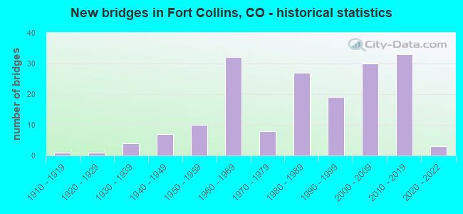
- New bridges - historical statistics
- 11910-1919
- 11920-1929
- 41930-1939
- 71940-1949
- 101950-1959
- 321960-1969
- 81970-1979
- 271980-1989
- 191990-1999
- 302000-2009
- 332010-2019
- 32020-2022
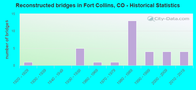
- Reconstructed bridges - Historical Statistics
- 11920-1929
- 01930-1939
- 01940-1949
- 51950-1959
- 11960-1969
- 11970-1979
- 131980-1989
- 41990-1999
- 42000-2009
- 42010-2019

- Bridge Condition - Deck
- 11.3%Very good
- 43.4%Good
- 32.1%Satisfactory
- 11.3%Fair
- 1.9%Poor
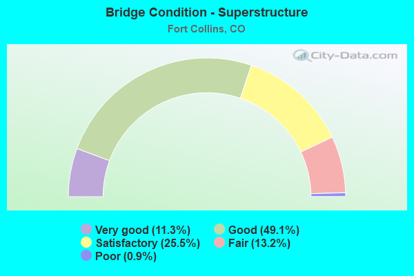
- Bridge Condition - Superstructure
- 11.3%Very good
- 49.1%Good
- 25.5%Satisfactory
- 13.2%Fair
- 0.9%Poor
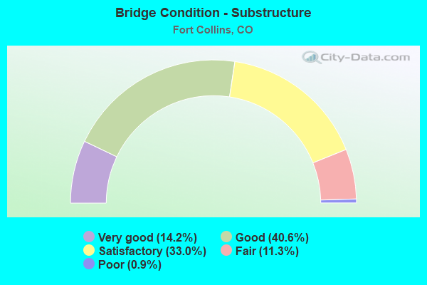
- Bridge Condition - Substructure
- 14.2%Very good
- 40.6%Good
- 33.0%Satisfactory
- 11.3%Fair
- 0.9%Poor
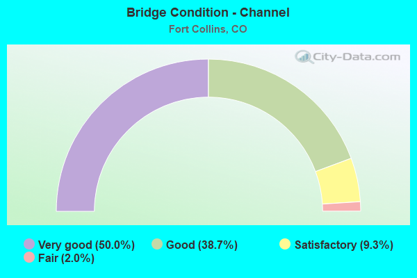
- Bridge Condition - Channel
- 50.0%Very good
- 38.7%Good
- 9.3%Satisfactory
- 2.0%Fair
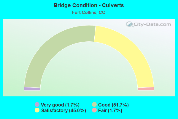
- Bridge Condition - Culverts
- 1.7%Very good
- 51.7%Good
- 45.0%Satisfactory
- 1.7%Fair
Find on map >> Show street view
Structure Number: FCLMY-0.1-RVSDE, Location: 0.1 Mi N of Riverside Ave (Lat: 40.579667, Lng: -105.057389), Route carried "on" structure: City street , Year Built: 1980, Status: Open, Structure Length: 8.12m (26.64ft), Average Daily Traffic: 26,362 (year 2020), Truck Traffic: 12%, Average Future Daily Traffic: 32,953 (year 2040), Design Load: HS 20, Features Intersected: Cache La Poudre River, Facility Carried by Structure: LeMay Avenue
Minimum Vertical Clearance: 30+ m (98+ ft), Kilometerpoint: 4.670, Lanes on structure: 4, Owner: City or Municipal Highway Agency, Approaching Roadway Width: 15.8m (51.8ft), Material/Design: Prestressed concrete continuous, Design/Construction: Stringer/Multi-beam, Number Of Spans In Main Unit: 3, Length of Maximum Span: 28.7m (94.2ft), Curb or Sidewalk Widths: Left: 1.8m (5.9ft), Right: 1.8m (5.9ft), Curb-To-Curb Width: 15.8m (51.8ft), Out-to-Out Width: 20.1m (65.9ft)
Condition: Deck: Good, Superstructure: Good, Substructure: Fair, Channel: Satisfactory, Operating Rating: 57.5 metric tons, Method Used To Determine Operating Rating: Load Factor (LF), Inventory Rating: 34.5 metric tons, Method Used To Determine Inventory Rating: Load Factor (LF), Structural Evaluation: Somewhat better than minimum adequacy, Deck Geometry: Meets minimum limits, Waterway Adequacy: Equal to present desirable criteria, Approach Roadway Alignment: Equal to present desirable criteria, Designated Inspection Frequency: Every 24 months, Inspection Date: April 2021, Deck Structure Type: Concrete Cast-file-Place, Wearing Surface/Protective System: Wearing Surface: Bituminous, Membrane: Preformed Fabric
Find on map >> Show street view
Structure Number: FCLMY-0.1-STUT, Location: 0.1 Mi N of Stuart St (Lat: 40.565028, Lng: -105.058083), Route carried "on" structure: City street , Year Built: 1975, Status: Open, Structure Length: 2.97m (9.74ft), Average Daily Traffic: 32,532 (year 2020), Truck Traffic: 11%, Average Future Daily Traffic: 40,665 (year 2040), Features Intersected: Spring Creek, Facility Carried by Structure: LeMay Avenue
Minimum Vertical Clearance: 30+ m (98+ ft), Kilometerpoint: 3.044, Lanes on structure: 5, Owner: City or Municipal Highway Agency, Approaching Roadway Width: 18.3m (60.0ft), Material/Design: Concrete continuous, Design/Construction: Slab, Number Of Spans In Main Unit: 3, Length of Maximum Span: 11.0m (36.1ft), Curb or Sidewalk Widths: Left: 1.8m (5.9ft), Right: 1.8m (5.9ft), Curb-To-Curb Width: 18.3m (60.0ft), Out-to-Out Width: 22.7m (74.5ft)
Condition: Deck: Satisfactory, Superstructure: Satisfactory, Substructure: Good, Channel: Very good, Operating Rating: 36.3 metric tons, Method Used To Determine Operating Rating: Field evaluation and documented engineering judgment, Inventory Rating: 32.7 metric tons, Method Used To Determine Inventory Rating: Field evaluation and documented engineering judgment, Structural Evaluation: Equal to present minimum criteria, Deck Geometry: High priority of replacement, Waterway Adequacy: Equal to present desirable criteria, Approach Roadway Alignment: Equal to present desirable criteria, Length Of Structure Improvement: 5.91m (19.39ft), Designated Inspection Frequency: Every 24 months, Inspection Date: June 2021, Deck Structure Type: Concrete Cast-file-Place, Wearing Surface/Protective System: Wearing Surface: Bituminous
Find on map >> Show street view
Structure Number: FCLMY-0.2-SRGB, Location: 0.8 Mi N of E. Trilby Rd (Lat: 40.506750, Lng: -105.058250), Route carried "on" structure: City street , Year Built: 1985, Status: Open, Structure Length: 1.13m (3.71ft), Average Daily Traffic: 15,402 (year 2020), Truck Traffic: 10%, Average Future Daily Traffic: 19,253 (year 2040), Design Load: HS 20, Features Intersected: Fossil Creek, Facility Carried by Structure: South LeMay Avenue
Minimum Vertical Clearance: 30+ m (98+ ft), Kilometerpoint: 2.954, Lanes on structure: 5, Owner: City or Municipal Highway Agency, Approaching Roadway Width: 21.4m (70.2ft), Skew: 1 degrees, Material/Design: Prestressed concrete, Design/Construction: Tee Beam, Number Of Spans In Main Unit: 1, Length of Maximum Span: 10.1m (33.1ft), Curb or Sidewalk Widths: Left: 2.3m (7.5ft), Right: 2.3m (7.5ft), Curb-To-Curb Width: 21.4m (70.2ft), Out-to-Out Width: 26.8m (87.9ft)
Condition: Deck: Good, Superstructure: Good, Substructure: Satisfactory, Channel: Good, Operating Rating: 36.3 metric tons, Method Used To Determine Operating Rating: Field evaluation and documented engineering judgment, Inventory Rating: 32.7 metric tons, Method Used To Determine Inventory Rating: Field evaluation and documented engineering judgment, Structural Evaluation: Equal to present minimum criteria, Deck Geometry: Somewhat better than minimum adequacy, Waterway Adequacy: Better than present minimum criteria, Approach Roadway Alignment: Equal to present desirable criteria, Designated Inspection Frequency: Every 24 months, Inspection Date: June 2021, Deck Structure Type: Concrete Cast-file-Place, Wearing Surface/Protective System: Wearing Surface: Bituminous
Find on map >> Show street view
Structure Number: FCLMY-0.2-TRILB, Location: 0.2 Mi N of Trilby Road (Lat: 40.497806, Lng: -105.058306), Route carried "on" structure: City street , Year Built: 1986, Status: Open, Structure Length: 1.94m (6.36ft), Average Daily Traffic: 14,714 (year 2020), Truck Traffic: 12%, Average Future Daily Traffic: 18,393 (year 2040), Design Load: HS 20, Features Intersected: Fossil Creek Tributary, Facility Carried by Structure: South LeMay Avenue
Minimum Vertical Clearance: 30+ m (98+ ft), Kilometerpoint: 1.958, Lanes on structure: 5, Owner: City or Municipal Highway Agency, Approaching Roadway Width: 22.3m (73.2ft), Material/Design: Concrete, Design/Construction: Culvert, Number Of Spans In Main Unit: 7, Length of Maximum Span: 3.7m (12.1ft), Curb or Sidewalk Widths: Left: 2.3m (7.5ft), Right: 2.0m (6.6ft), Curb-To-Curb Width: 22.3m (73.2ft), Out-to-Out Width: 27.4m (89.9ft)
Condition: Channel: Good, Culverts: Satisfactory, Operating Rating: 36.3 metric tons, Method Used To Determine Operating Rating: Field evaluation and documented engineering judgment, Inventory Rating: 32.7 metric tons, Method Used To Determine Inventory Rating: Field evaluation and documented engineering judgment, Structural Evaluation: Equal to present minimum criteria, Deck Geometry: Equal to present minimum criteria, Waterway Adequacy: Better than present minimum criteria, Approach Roadway Alignment: Equal to present desirable criteria, Designated Inspection Frequency: Every 24 months, Inspection Date: June 2021
Find on map >> Show street view
Structure Number: FCLMY-1.2-VINE, Location: 1.2 Mi N of Vine Drive (Lat: 40.613500, Lng: -105.057500), Route carried "on" structure: City street , Year Built: 1958, Year Reconstructed: 1990, Status: Open, Structure Length: 1.81m (5.94ft), Average Daily Traffic: 10,088 (year 2020), Truck Traffic: 4%, Average Future Daily Traffic: 12,610 (year 2040), Features Intersected: Larimer and Weld Canal, Facility Carried by Structure: LeMay Avenue
Minimum Vertical Clearance: 30+ m (98+ ft), Kilometerpoint: 2.091, Lanes on structure: 2, Owner: City or Municipal Highway Agency, Approaching Roadway Width: 8.5m (27.9ft), Skew: 3 degrees, Material/Design: Prestressed concrete, Design/Construction: Tee Beam, Number Of Spans In Main Unit: 1, Length of Maximum Span: 17.1m (56.1ft), Curb-To-Curb Width: 8.8m (28.9ft), Out-to-Out Width: 9.2m (30.2ft)
Condition: Deck: Fair, Superstructure: Fair, Substructure: Satisfactory, Channel: Good, Operating Rating: 36.3 metric tons, Method Used To Determine Operating Rating: Field evaluation and documented engineering judgment, Inventory Rating: 32.7 metric tons, Method Used To Determine Inventory Rating: Field evaluation and documented engineering judgment, Structural Evaluation: Somewhat better than minimum adequacy, Deck Geometry: High priority of replacement, Waterway Adequacy: Equal to present desirable criteria, Approach Roadway Alignment: Equal to present desirable criteria, Length Of Structure Improvement: 1.81m (5.94ft), Designated Inspection Frequency: Every 24 months, Inspection Date: April 2021, Bridge Improvement Cost: $286,000, Roadway Improvement Cost: $29,000, Total Project Cost: $315,000 ( Estimate for 2019), Deck Structure Type: Concrete Cast-file-Place, Wearing Surface/Protective System: Wearing Surface: Monolithic Concrete
Find on map >> Show street view
Structure Number: FCLNDS-0.1-BDWK, Location: 0.1 Mi N of Boardwalk Dr (Lat: 40.533639, Lng: -105.072278), Route carried "on" structure: City street , Year Built: 1982, Status: Open, Structure Length: 0.73m (2.40ft), Average Daily Traffic: 2,869 (year 2020), Truck Traffic: 7%, Average Future Daily Traffic: 3,586 (year 2040), Features Intersected: Larimer Co. Canal No. 2, Facility Carried by Structure: Landing Drive
Minimum Vertical Clearance: 30+ m (98+ ft), Kilometerpoint: 0.186, Lanes on structure: 2, Owner: City or Municipal Highway Agency, Approaching Roadway Width: 13.4m (44.0ft), Skew: 3 degrees, Material/Design: Concrete, Design/Construction: Culvert, Number Of Spans In Main Unit: 1, Length of Maximum Span: 7.3m (24.0ft), Curb or Sidewalk Widths: Left: 2.1m (6.9ft), Right: 2.2m (7.2ft), Curb-To-Curb Width: 13.4m (44.0ft), Out-to-Out Width: 18.6m (61.0ft)
Condition: Channel: Good, Culverts: Satisfactory, Structural Evaluation: Equal to present minimum criteria, Deck Geometry: Better than present minimum criteria, Waterway Adequacy: Equal to present desirable criteria, Approach Roadway Alignment: Equal to present desirable criteria, Designated Inspection Frequency: Every 24 months, Inspection Date: March 2021
Find on map >> Show street view
Structure Number: FCMAXG-0.1-HRMY, Location: 100 ft S of W Co. Rd 38 (Lat: 40.523017, Lng: -105.080742), Route carried "on" structure: City street , Year Built: 2019, Status: Open, Structure Length: 5.13m (16.83ft), Average Daily Traffic: 291 (year 2020), Truck Traffic: 79%, Average Future Daily Traffic: 364 (year 2040), Design Load: HL 93, Features Intersected: Mail Creek, Facility Carried by Structure: HCL+PGL BRT Guide
Minimum Vertical Clearance: 30+ m (98+ ft), Kilometerpoint: 0.000, Lanes on structure: 2, Toll: Toll bridge is a segment, Owner: City or Municipal Highway Agency, Approaching Roadway Width: 7.0m (23.0ft), Material/Design: Prestressed concrete continuous, Design/Construction: Stringer/Multi-beam, Number Of Spans In Main Unit: 2, Length of Maximum Span: 23.3m (76.4ft), Curb-To-Curb Width: 7.0m (23.0ft), Out-to-Out Width: 7.9m (25.9ft)
Condition: Deck: Good, Superstructure: Good, Substructure: Very good, Channel: Very good, Operating Rating: 32.7 metric tons, Method Used To Determine Operating Rating: No rating analysis performed, Inventory Rating: 32.7 metric tons, Method Used To Determine Inventory Rating: No rating analysis performed, Structural Evaluation: Better than present minimum criteria, Deck Geometry: Meets minimum limits, Waterway Adequacy: Equal to present desirable criteria, Approach Roadway Alignment: Equal to present desirable criteria, Designated Inspection Frequency: Every 24 months, Inspection Date: April 2021, Deck Structure Type: Concrete Cast-file-Place, Wearing Surface/Protective System: Wearing Surface: Monolithic Concrete, Deck Protection: Epoxy Coated Reinforcing
Find on map >> Show street view
Structure Number: FCMCCLE-0.1-FTH, Location: 20 ft S. W foothill Pkwy (Lat: 40.542414, Lng: -105.079883), Route carried "on" structure: City street , Year Built: 2019, Status: Open, Structure Length: 0.64m (2.10ft), Average Daily Traffic: 5,891 (year 2020), Truck Traffic: 11%, Average Future Daily Traffic: 7,364 (year 2040), Features Intersected: Larimer County Canal #2, Facility Carried by Structure: Mc Clelland Drive
Minimum Vertical Clearance: 30+ m (98+ ft), Kilometerpoint: 0.481, Lanes on structure: 2, Owner: City or Municipal Highway Agency, Approaching Roadway Width: 6.7m (22.0ft), Material/Design: Concrete, Design/Construction: Culvert, Number Of Spans In Main Unit: 1, Length of Maximum Span: 6.4m (21.0ft), Curb or Sidewalk Widths: Left: 1.8m (5.9ft), Right: 1.5m (4.9ft), Curb-To-Curb Width: 12.2m (40.0ft), Out-to-Out Width: 16.5m (54.1ft)
Condition: Channel: Very good, Culverts: Good, Operating Rating: 32.7 metric tons, Method Used To Determine Operating Rating: No rating analysis performed, Inventory Rating: 32.7 metric tons, Method Used To Determine Inventory Rating: No rating analysis performed, Structural Evaluation: Better than present minimum criteria, Deck Geometry: Somewhat better than minimum adequacy, Waterway Adequacy: Equal to present desirable criteria, Approach Roadway Alignment: Equal to present desirable criteria, Designated Inspection Frequency: Every 24 months, Inspection Date: April 2021
Find on map >> Show street view
Structure Number: FCMOSS-0.1-BENT, Location: 150 Ft N of Butte Pass (Lat: 40.530917, Lng: -105.089222), Route carried "on" structure: City street , Year Built: 1985, Status: Open, Structure Length: 0.66m (2.17ft), Average Daily Traffic: 797 (year 2020), Truck Traffic: 7%, Average Future Daily Traffic: 996 (year 2040), Design Load: HS 20, Features Intersected: Moss Creek, Facility Carried by Structure: Moss Creek Drive
Minimum Vertical Clearance: 30+ m (98+ ft), Kilometerpoint: 0.193, Lanes on structure: 2, Owner: City or Municipal Highway Agency, Approaching Roadway Width: 10.7m (35.1ft), Skew: 1 degrees, Material/Design: Concrete, Design/Construction: Culvert, Number Of Spans In Main Unit: 2, Length of Maximum Span: 3.1m (10.2ft), Curb or Sidewalk Widths: Left: 1.8m (5.9ft), Right: 1.7m (5.6ft), Curb-To-Curb Width: 11.2m (36.7ft), Out-to-Out Width: 15.5m (50.9ft)
Condition: Channel: Good, Culverts: Good, Operating Rating: 52.0 metric tons, Method Used To Determine Operating Rating: Load Factor (LF), Inventory Rating: 31.1 metric tons, Method Used To Determine Inventory Rating: Load Factor (LF), Structural Evaluation: Better than present minimum criteria, Deck Geometry: Better than present minimum criteria, Waterway Adequacy: Equal to present desirable criteria, Approach Roadway Alignment: Equal to present desirable criteria, Designated Inspection Frequency: Every 24 months, Inspection Date: June 2021
Find on map >> Show street view
Structure Number: FCMRSN-0.0-RYMT, Location: 100 Ft W of Meadowlark Av (Lat: 40.549444, Lng: -105.086750), Route carried "on" structure: City street , Year Built: 1968, Status: Open, Structure Length: 0.95m (3.12ft), Average Daily Traffic: 806 (year 2020), Truck Traffic: 7%, Average Future Daily Traffic: 1,008 (year 2040), Features Intersected: New Mercer Canal, Facility Carried by Structure: Morsman Drive
Minimum Vertical Clearance: 30+ m (98+ ft), Kilometerpoint: 0.348, Lanes on structure: 2, Owner: City or Municipal Highway Agency, Approaching Roadway Width: 12.2m (40.0ft), Skew: 4 degrees, Material/Design: Prestressed concrete, Design/Construction: Tee Beam, Number Of Spans In Main Unit: 1, Length of Maximum Span: 8.8m (28.9ft), Curb or Sidewalk Widths: Left: 1.1m (3.6ft), Right: 1.1m (3.6ft), Curb-To-Curb Width: 12.2m (40.0ft), Out-to-Out Width: 14.6m (47.9ft)
Condition: Deck: Satisfactory, Superstructure: Fair, Substructure: Fair, Channel: Satisfactory, Operating Rating: 36.3 metric tons, Method Used To Determine Operating Rating: Field evaluation and documented engineering judgment, Inventory Rating: 32.7 metric tons, Method Used To Determine Inventory Rating: Field evaluation and documented engineering judgment, Structural Evaluation: Somewhat better than minimum adequacy, Deck Geometry: Equal to present desirable criteria, Waterway Adequacy: Equal to present desirable criteria, Approach Roadway Alignment: Equal to present desirable criteria, Designated Inspection Frequency: Every 24 months, Inspection Date: April 2021, Deck Structure Type: Concrete Cast-file-Place, Wearing Surface/Protective System: Wearing Surface: Bituminous
Find on map >> Show street view
Structure Number: FCMTCL-0.1-HTH, Location: 0.1 Mi. S of Horsetooth (Lat: 40.537222, Lng: -105.075611), Route carried "on" structure: City street , Year Built: 1992, Status: Open, Structure Length: 0.86m (2.82ft), Average Daily Traffic: 2,007 (year 2020), Truck Traffic: 6%, Average Future Daily Traffic: 2,509 (year 2040), Design Load: HS 20, Features Intersected: Larimer Co. Canal No. 2, Facility Carried by Structure: Mitchell Drive
Minimum Vertical Clearance: 30+ m (98+ ft), Kilometerpoint: 0.196, Lanes on structure: 2, Owner: City or Municipal Highway Agency, Approaching Roadway Width: 9.8m (32.2ft), Skew: 4 degrees, Material/Design: Concrete, Design/Construction: Frame, Number Of Spans In Main Unit: 1, Length of Maximum Span: 7.9m (25.9ft), Curb or Sidewalk Widths: Left: 1.7m (5.6ft), Right: 1.8m (5.9ft), Curb-To-Curb Width: 11.0m (36.1ft), Out-to-Out Width: 15.3m (50.2ft)
Condition: Deck: Fair, Superstructure: Fair, Substructure: Satisfactory, Channel: Good, Operating Rating: 36.3 metric tons, Method Used To Determine Operating Rating: Field evaluation and documented engineering judgment, Inventory Rating: 32.7 metric tons, Method Used To Determine Inventory Rating: Field evaluation and documented engineering judgment, Structural Evaluation: Somewhat better than minimum adequacy, Deck Geometry: Somewhat better than minimum adequacy, Waterway Adequacy: Equal to present desirable criteria, Approach Roadway Alignment: Equal to present desirable criteria, Designated Inspection Frequency: Every 24 months, Inspection Date: April 2021, Deck Structure Type: Other, Wearing Surface/Protective System: Wearing Surface: Bituminous
Find on map >> Show street view
Structure Number: FCMTV-1.2-SUMV, Location: 0.27 MI W of I-25 (Lat: 40.610222, Lng: -105.007167), Route carried "on" structure: City street , Year Built: 1987, Year Reconstructed: 2000, Status: Open, Structure Length: 0.87m (2.85ft), Average Daily Traffic: 8,260 (year 2020), Truck Traffic: 22%, Average Future Daily Traffic: 10,325 (year 2040), Design Load: HS 20, Features Intersected: Brewery Drainage Pond, Facility Carried by Structure: Mountain Vista Dr
Minimum Vertical Clearance: 30+ m (98+ ft), Kilometerpoint: 2.700, Lanes on structure: 2, Owner: City or Municipal Highway Agency, Approaching Roadway Width: 13.7m (44.9ft), Material/Design: Concrete, Design/Construction: Culvert, Number Of Spans In Main Unit: 3, Length of Maximum Span: 2.7m (8.9ft), Curb or Sidewalk Widths: Left: 2.4m (7.9ft), Right: 2.3m (7.5ft), Curb-To-Curb Width: 21.4m (70.2ft), Out-to-Out Width: 34.6m (113.5ft)
Condition: Channel: Very good, Culverts: Satisfactory, Operating Rating: 97.3 metric tons, Method Used To Determine Operating Rating: Load Factor (LF), Inventory Rating: 58.3 metric tons, Method Used To Determine Inventory Rating: Load Factor (LF), Structural Evaluation: Equal to present minimum criteria, Deck Geometry: Superior to present desirable criteria, Waterway Adequacy: Equal to present desirable criteria, Approach Roadway Alignment: Equal to present desirable criteria, Designated Inspection Frequency: Every 24 months, Inspection Date: June 2021
Find on map >> Show street view
Structure Number: FCMULB-0.0-BRYN, Location: 50 Ft E of Bryan Avenue (Lat: 40.581722, Lng: -105.106000), Route carried "on" structure: City street , Year Built: 1920, Year Reconstructed: 2003, Status: Open, Structure Length: 0.69m (2.26ft), Average Daily Traffic: 16,388 (year 2021), Truck Traffic: 10%, Average Future Daily Traffic: 20,485 (year 2041), Features Intersected: Larimer Co. Canal No. 2, Facility Carried by Structure: Mulberry Street
Minimum Vertical Clearance: 30+ m (98+ ft), Kilometerpoint: 3.642, Lanes on structure: 3, Owner: City or Municipal Highway Agency, Approaching Roadway Width: 13.4m (44.0ft), Skew: 3 degrees, Material/Design: Concrete, Design/Construction: Slab, Number Of Spans In Main Unit: 1, Length of Maximum Span: 6.1m (20.0ft), Curb or Sidewalk Widths: Left: 0.0m, Right: 0.8m (2.6ft), Curb-To-Curb Width: 15.1m (49.5ft), Out-to-Out Width: 16.6m (54.5ft)
Condition: Deck: Good, Superstructure: Good, Substructure: Fair, Channel: Good, Operating Rating: 36.3 metric tons, Method Used To Determine Operating Rating: Field evaluation and documented engineering judgment, Inventory Rating: 32.7 metric tons, Method Used To Determine Inventory Rating: Field evaluation and documented engineering judgment, Structural Evaluation: Somewhat better than minimum adequacy, Deck Geometry: Equal to present minimum criteria, Waterway Adequacy: Equal to present desirable criteria, Approach Roadway Alignment: Equal to present desirable criteria, Designated Inspection Frequency: Every 24 months, Inspection Date: April 2021, Deck Structure Type: Concrete Cast-file-Place, Wearing Surface/Protective System: Wearing Surface: Bituminous
Find on map >> Show street view
Structure Number: FCMULB-0.1-OVLD, Location: 0.1 M E of Overland Trail (Lat: 40.582250, Lng: -105.131583), Route carried "on" structure: County highway , Year Built: 1930, Year Reconstructed: 1950, Status: Open, Structure Length: 0.82m (2.69ft), Average Daily Traffic: 4,162 (year 2021), Truck Traffic: 9%, Average Future Daily Traffic: 5,203 (year 2041), Features Intersected: Pleas. Valley Lake Canal, Facility Carried by Structure: Mulberry St/CR 46
Minimum Vertical Clearance: 30+ m (98+ ft), Kilometerpoint: 0.190, Lanes on structure: 2, Owner: County Highway Agency, Approaching Roadway Width: 10.1m (33.1ft), Skew: 9 degrees, Material/Design: Concrete, Design/Construction: Slab, Number Of Spans In Main Unit: 1, Length of Maximum Span: 7.3m (24.0ft), Curb-To-Curb Width: 8.0m (26.2ft), Out-to-Out Width: 8.6m (28.2ft)
Condition: Deck: Satisfactory, Superstructure: Satisfactory, Substructure: Fair, Channel: Satisfactory, Operating Rating: 36.3 metric tons, Method Used To Determine Operating Rating: Field evaluation and documented engineering judgment, Inventory Rating: 32.7 metric tons, Method Used To Determine Inventory Rating: Field evaluation and documented engineering judgment, Structural Evaluation: Somewhat better than minimum adequacy, Deck Geometry: High priority of corrective action, Waterway Adequacy: Equal to present desirable criteria, Approach Roadway Alignment: Equal to present desirable criteria, Length Of Structure Improvement: 0.82m (2.69ft), Designated Inspection Frequency: Every 24 months, Inspection Date: April 2021, Bridge Improvement Cost: $137,000, Roadway Improvement Cost: $14,000, Total Project Cost: $151,000 ( Estimate for 2019), Deck Structure Type: Concrete Cast-file-Place, Wearing Surface/Protective System: Wearing Surface: Bituminous
Find on map >> Show street view
Structure Number: FCMULB-CRESTMRA, Location: Just E. of Crestmore (Lat: 40.581944, Lng: -105.110278), Route carried "on" structure: City street , Year Built: 2016, Status: Open, Structure Length: 0.69m (2.26ft), Average Daily Traffic: 16,159 (year 2021), Truck Traffic: 6%, Average Future Daily Traffic: 20,199 (year 2041), Features Intersected: Mercer Ditch, Facility Carried by Structure: Mulberry Street
Minimum Vertical Clearance: 30+ m (98+ ft), Kilometerpoint: 4.008, Lanes on structure: 3, Owner: City or Municipal Highway Agency, Approaching Roadway Width: 15.8m (51.8ft), Skew: 2 degrees, Material/Design: Concrete, Design/Construction: Frame, Number Of Spans In Main Unit: 1, Length of Maximum Span: 6.9m (22.6ft), Curb or Sidewalk Widths: Left: 3.0m (9.8ft), Right: 1.3m (4.3ft), Curb-To-Curb Width: 16.9m (55.4ft), Out-to-Out Width: 21.8m (71.5ft)
Condition: Deck: Good, Superstructure: Good, Substructure: Good, Channel: Very good, Operating Rating: 36.3 metric tons, Method Used To Determine Operating Rating: Field evaluation and documented engineering judgment, Inventory Rating: 32.7 metric tons, Method Used To Determine Inventory Rating: Field evaluation and documented engineering judgment, Structural Evaluation: Better than present minimum criteria, Deck Geometry: Superior to present desirable criteria, Waterway Adequacy: Equal to present desirable criteria, Approach Roadway Alignment: Equal to present desirable criteria, Designated Inspection Frequency: Every 24 months, Inspection Date: November 2021, Deck Structure Type: Other, Wearing Surface/Protective System: Wearing Surface: Bituminous
Find on map >> Show street view
Structure Number: FCOAK-0.1-BRYN, Location: 20 Ft W of Bryan Avenue (Lat: 40.585700, Lng: -105.105850), Route carried "on" structure: City street , Year Built: 1987, Status: Open, Structure Length: 0.76m (2.49ft), Average Daily Traffic: 252 (year 2021), Truck Traffic: 2%, Average Future Daily Traffic: 315 (year 2041), Design Load: HS 20, Features Intersected: Larimer Co. Canal No. 2, Facility Carried by Structure: Oak Street
Minimum Vertical Clearance: 30+ m (98+ ft), Kilometerpoint: 0.985, Lanes on structure: 2, Owner: City or Municipal Highway Agency, Approaching Roadway Width: 11.1m (36.4ft), Skew: 1 degrees, Material/Design: Prestressed concrete, Design/Construction: Slab, Number Of Spans In Main Unit: 1, Length of Maximum Span: 6.2m (20.3ft), Curb or Sidewalk Widths: Left: 1.2m (3.9ft), Right: 1.2m (3.9ft), Curb-To-Curb Width: 11.1m (36.4ft), Out-to-Out Width: 14.3m (46.9ft)
Condition: Deck: Good, Superstructure: Good, Substructure: Satisfactory, Channel: Very good, Operating Rating: 49.8 metric tons, Method Used To Determine Operating Rating: Load Factor (LF), Inventory Rating: 38.7 metric tons, Method Used To Determine Inventory Rating: Load Factor (LF), Structural Evaluation: Equal to present minimum criteria, Deck Geometry: Superior to present desirable criteria, Waterway Adequacy: Equal to present desirable criteria, Approach Roadway Alignment: Equal to present desirable criteria, Designated Inspection Frequency: Every 24 months, Inspection Date: April 2021, Deck Structure Type: Other, Wearing Surface/Protective System: Wearing Surface: Bituminous, Membrane: Built-up
Find on map >> Show street view
Structure Number: FCOMR-0.1-SDCK, Location: 200 Ft. N of Saddle Ck Dr (Lat: 40.511956, Lng: -105.027194), Route carried "on" structure: City street , Year Built: 2002, Status: Open, Structure Length: 0.68m (2.23ft), Average Daily Traffic: 489 (year 2020), Truck Traffic: 13%, Average Future Daily Traffic: 611 (year 2040), Design Load: HS 20, Features Intersected: McClellands Channel, Facility Carried by Structure: Old Mill Road
Minimum Vertical Clearance: 30+ m (98+ ft), Kilometerpoint: 0.496, Lanes on structure: 2, Owner: City or Municipal Highway Agency, Approaching Roadway Width: 10.4m (34.1ft), Material/Design: Concrete, Design/Construction: Frame, Number Of Spans In Main Unit: 1, Length of Maximum Span: 6.2m (20.3ft), Curb or Sidewalk Widths: Left: 3.2m (10.5ft), Right: 3.3m (10.8ft), Curb-To-Curb Width: 10.4m (34.1ft), Out-to-Out Width: 17.6m (57.7ft)
Condition: Deck: Good, Superstructure: Good, Substructure: Satisfactory, Channel: Very good, Operating Rating: 36.3 metric tons, Method Used To Determine Operating Rating: Field evaluation and documented engineering judgment, Inventory Rating: 32.7 metric tons, Method Used To Determine Inventory Rating: Field evaluation and documented engineering judgment, Structural Evaluation: Equal to present minimum criteria, Deck Geometry: Equal to present minimum criteria, Waterway Adequacy: Equal to present desirable criteria, Approach Roadway Alignment: Equal to present desirable criteria, Designated Inspection Frequency: Every 24 months, Inspection Date: June 2021, Deck Structure Type: Other, Wearing Surface/Protective System: Wearing Surface: Bituminous
Find on map >> Show street view
Structure Number: FCPALM-0.1-HOG, Location: .1 West of Hogan Dr (Lat: 40.519667, Lng: -105.070056), Route carried "on" structure: City street , Year Built: 2010, Status: Open, Structure Length: 1.83m (6.00ft), Average Daily Traffic: 12 (year 2016), Average Future Daily Traffic: 19 (year 2036), Features Intersected: Spillway, Facility Carried by Structure: Palmer Dr
Minimum Vertical Clearance: 30+ m (98+ ft), Kilometerpoint: 0.789, Lanes on structure: 2, Owner: City or Municipal Highway Agency, Approaching Roadway Width: 6.4m (21.0ft), Material/Design: Concrete, Design/Construction: Culvert, Number Of Spans In Main Unit: 6, Length of Maximum Span: 3.0m (9.8ft), Curb-To-Curb Width: 12.0m (39.4ft), Out-to-Out Width: 12.6m (41.3ft)
Condition: Channel: Very good, Culverts: Satisfactory, Operating Rating: 36.3 metric tons, Method Used To Determine Operating Rating: Field evaluation and documented engineering judgment, Inventory Rating: 32.7 metric tons, Method Used To Determine Inventory Rating: Field evaluation and documented engineering judgment, Structural Evaluation: Equal to present minimum criteria, Deck Geometry: Superior to present desirable criteria, Waterway Adequacy: Equal to present desirable criteria, Approach Roadway Alignment: Equal to present desirable criteria, Designated Inspection Frequency: Every 24 months, Inspection Date: April 2021
Find on map >> Show street view
Structure Number: FCPLM-W0.1-CTYP, Location: 0.1 Mi W of City Park Dr. (Lat: 40.576667, Lng: -105.101972), Route carried "on" structure: City street , Year Built: 1950, Status: Open, Structure Length: 0.65m (2.13ft), Average Daily Traffic: 4,168 (year 2021), Truck Traffic: 6%, Average Future Daily Traffic: 5,210 (year 2041), Features Intersected: Larimer Co. Canal No. 2, Facility Carried by Structure: Plum Street
Minimum Vertical Clearance: 30+ m (98+ ft), Kilometerpoint: 0.264, Lanes on structure: 2, Owner: City or Municipal Highway Agency, Approaching Roadway Width: 8.5m (27.9ft), Skew: 2 degrees, Material/Design: Concrete, Design/Construction: Culvert, Number Of Spans In Main Unit: 1, Length of Maximum Span: 6.5m (21.3ft), Curb or Sidewalk Widths: Left: 1.8m (5.9ft), Right: 1.8m (5.9ft), Curb-To-Curb Width: 8.0m (26.2ft), Out-to-Out Width: 11.6m (38.1ft)
Condition: Channel: Very good, Culverts: Satisfactory, Operating Rating: 36.3 metric tons, Method Used To Determine Operating Rating: Field evaluation and documented engineering judgment, Inventory Rating: 32.7 metric tons, Method Used To Determine Inventory Rating: Field evaluation and documented engineering judgment, Structural Evaluation: Equal to present minimum criteria, Deck Geometry: High priority of corrective action, Waterway Adequacy: Equal to present desirable criteria, Approach Roadway Alignment: Equal to present desirable criteria, Length Of Structure Improvement: 0.65m (2.13ft), Designated Inspection Frequency: Every 24 months, Inspection Date: April 2021, Bridge Improvement Cost: $109,000, Roadway Improvement Cost: $11,000, Total Project Cost: $120,000 ( Estimate for 2019)
Find on map >> Show street view
Structure Number: FCPROS-0.5-I25A, Location: 0.5 Mi West of I25 (Lat: 40.566722, Lng: -105.008000), Route carried "on" structure: City street , Year Built: 2016, Status: Open, Structure Length: 1.18m (3.87ft), Average Daily Traffic: 25,235 (year 2020), Truck Traffic: 4%, Average Future Daily Traffic: 31,544 (year 2040), Features Intersected: Box Elder Creek, Facility Carried by Structure: Prospect Avenue
Minimum Vertical Clearance: 30+ m (98+ ft), Kilometerpoint: 11.407, Lanes on structure: 3, Owner: City or Municipal Highway Agency, Approaching Roadway Width: 20.3m (66.6ft), Skew: 3 degrees, Material/Design: Concrete, Design/Construction: Culvert, Number Of Spans In Main Unit: 2, Length of Maximum Span: 5.5m (18.0ft), Curb or Sidewalk Widths: Left: 2.9m (9.5ft), Right: 2.9m (9.5ft), Curb-To-Curb Width: 31.2m (102.4ft), Out-to-Out Width: 32.2m (105.6ft)
Condition: Channel: Good, Culverts: Good, Operating Rating: 36.3 metric tons, Method Used To Determine Operating Rating: Field evaluation and documented engineering judgment, Inventory Rating: 32.7 metric tons, Method Used To Determine Inventory Rating: Field evaluation and documented engineering judgment, Structural Evaluation: Better than present minimum criteria, Deck Geometry: Superior to present desirable criteria, Waterway Adequacy: Equal to present minimum criteria, Approach Roadway Alignment: Equal to present desirable criteria, Designated Inspection Frequency: Every 24 months, Inspection Date: June 2021
Find on map >> Show street view
Structure Number: FCPRST-0.0LYNWA, Location: 20 Ft. E of Lynnwood St. (Lat: 40.567528, Lng: -105.102667), Route carried "on" structure: City street , Year Built: 1989, Status: Open, Structure Length: 1.06m (3.48ft), Average Daily Traffic: 28,200 (year 2021), Truck Traffic: 4%, Average Future Daily Traffic: 35,250 (year 2041), Design Load: HS 20, Features Intersected: Larimer Co. Canal No. 2, Facility Carried by Structure: Prospect Road
Minimum Vertical Clearance: 30+ m (98+ ft), Kilometerpoint: 3.272, Lanes on structure: 5, Owner: City or Municipal Highway Agency, Approaching Roadway Width: 21.3m (69.9ft), Skew: 5 degrees, Material/Design: Concrete, Design/Construction: Culvert, Number Of Spans In Main Unit: 1, Length of Maximum Span: 10.6m (34.8ft), Curb or Sidewalk Widths: Left: 2.3m (7.5ft), Right: 2.2m (7.2ft), Curb-To-Curb Width: 21.3m (69.9ft), Out-to-Out Width: 26.5m (86.9ft)
Condition: Channel: Good, Culverts: Satisfactory, Operating Rating: 47.0 metric tons, Method Used To Determine Operating Rating: Load Factor (LF), Inventory Rating: 28.1 metric tons, Method Used To Determine Inventory Rating: Load Factor (LF), Structural Evaluation: Equal to present minimum criteria, Deck Geometry: Somewhat better than minimum adequacy, Waterway Adequacy: Equal to present desirable criteria, Approach Roadway Alignment: Equal to present desirable criteria, Designated Inspection Frequency: Every 24 months, Inspection Date: April 2021
Find on map >> Show street view
Structure Number: FCPRST-0.1-SHPT, Location: 0.1 M E of Sharp Point Dr (Lat: 40.567167, Lng: -105.027667), Route carried "on" structure: City street , Year Built: 1986, Status: Open, Structure Length: 5.78m (18.96ft), Average Daily Traffic: 27,367 (year 2020), Truck Traffic: 11%, Average Future Daily Traffic: 34,209 (year 2040), Design Load: HS 20+Mod, Features Intersected: Cache La Poudre River, Facility Carried by Structure: Prospect Road
Minimum Vertical Clearance: 30+ m (98+ ft), Kilometerpoint: 9.688, Lanes on structure: 2, Owner: City or Municipal Highway Agency, Approaching Roadway Width: 18.3m (60.0ft), Material/Design: Prestressed concrete continuous, Design/Construction: Stringer/Multi-beam, Number Of Spans In Main Unit: 2, Length of Maximum Span: 27.9m (91.5ft), Curb or Sidewalk Widths: Left: 2.3m (7.5ft), Right: 2.3m (7.5ft), Curb-To-Curb Width: 18.3m (60.0ft), Out-to-Out Width: 23.4m (76.8ft)
Condition: Deck: Satisfactory, Superstructure: Good, Substructure: Satisfactory, Channel: Good, Operating Rating: 55.6 metric tons, Method Used To Determine Operating Rating: Load Factor (LF), Inventory Rating: 29.8 metric tons, Method Used To Determine Inventory Rating: Load Factor (LF), Structural Evaluation: Equal to present minimum criteria, Deck Geometry: Superior to present desirable criteria, Waterway Adequacy: Equal to present desirable criteria, Approach Roadway Alignment: Equal to present desirable criteria, Designated Inspection Frequency: Every 24 months, Inspection Date: April 2021, Deck Structure Type: Concrete Cast-file-Place, Wearing Surface/Protective System: Wearing Surface: Bituminous, Membrane: Preformed Fabric, Deck Protection: Epoxy Coated Reinforcing
Find on map >> Show street view
Structure Number: FCPRST-0.1BRTWA, Location: 0.1 Mi E of Brentwood Dr (Lat: 40.567417, Lng: -105.106444), Route carried "on" structure: City street , Year Built: 2014, Status: Open, Structure Length: 0.74m (2.43ft), Average Daily Traffic: 22,809 (year 2021), Truck Traffic: 7%, Average Future Daily Traffic: 28,511 (year 2041), Design Load: HL 93, Features Intersected: New Mercer Canal, Facility Carried by Structure: Prospect Road
Minimum Vertical Clearance: 30+ m (98+ ft), Kilometerpoint: 2.953, Lanes on structure: 5, Owner: City or Municipal Highway Agency, Approaching Roadway Width: 20.5m (67.3ft), Material/Design: Concrete, Design/Construction: Culvert, Number Of Spans In Main Unit: 1, Length of Maximum Span: 7.4m (24.3ft), Curb or Sidewalk Widths: Left: 2.4m (7.9ft), Right: 2.7m (8.9ft), Curb-To-Curb Width: 20.5m (67.3ft), Out-to-Out Width: 27.0m (88.6ft)
Condition: Channel: Very good, Culverts: Good, Operating Rating: 43.7 metric tons, Method Used To Determine Operating Rating: Load and Resistance Factor Rating (LRFR) rating reported by rating factor(RF) method using HL-93 loadings, Inventory Rating: 33.7 metric tons, Method Used To Determine Inventory Rating: Load and Resistance Factor Rating (LRFR) rating reported by rating factor(RF) method using HL-93 loadings, Structural Evaluation: Better than present minimum criteria, Deck Geometry: Somewhat better than minimum adequacy, Waterway Adequacy: Equal to present desirable criteria, Approach Roadway Alignment: Equal to present desirable criteria, Designated Inspection Frequency: Every 24 months, Inspection Date: June 2021
Find on map >> Show street view
Structure Number: FCPRST-0.2-TMBL, Location: 0.2 Mi E of Timberline Rd (Lat: 40.567556, Lng: -105.036972), Route carried "on" structure: City street , Year Built: 1987, Status: Open, Structure Length: 3.25m (10.66ft), Average Daily Traffic: 31,327 (year 2020), Truck Traffic: 7%, Average Future Daily Traffic: 39,159 (year 2040), Design Load: HS 20, Features Intersected: Spring Creek, Facility Carried by Structure: Prospect Road
Minimum Vertical Clearance: 30+ m (98+ ft), Kilometerpoint: 8.900, Lanes on structure: 5, Owner: City or Municipal Highway Agency, Approaching Roadway Width: 21.3m (69.9ft), Skew: 2 degrees, Material/Design: Concrete continuous, Design/Construction: Slab, Number Of Spans In Main Unit: 3, Length of Maximum Span: 11.9m (39.0ft), Curb or Sidewalk Widths: Left: 2.3m (7.5ft), Right: 2.3m (7.5ft), Curb-To-Curb Width: 21.4m (70.2ft), Out-to-Out Width: 26.6m (87.3ft)
Condition: Deck: Satisfactory, Superstructure: Satisfactory, Substructure: Good, Channel: Very good, Operating Rating: 76.8 metric tons, Method Used To Determine Operating Rating: Load Factor (LF), Inventory Rating: 46.1 metric tons, Method Used To Determine Inventory Rating: Load Factor (LF), Structural Evaluation: Equal to present minimum criteria, Deck Geometry: Somewhat better than minimum adequacy, Waterway Adequacy: Equal to present desirable criteria, Approach Roadway Alignment: Equal to present desirable criteria, Designated Inspection Frequency: Every 24 months, Inspection Date: June 2021, Deck Structure Type: Concrete Cast-file-Place, Wearing Surface/Protective System: Wearing Surface: Bituminous, Membrane: Preformed Fabric, Deck Protection: Epoxy Coated Reinforcing
Find on map >> Show street view
Structure Number: FCPRST-0.7-SHPT, Location: 0.7 Mi. E of Sharp Point (Lat: 40.567028, Lng: -105.020583), Route carried "on" structure: City street , Year Built: 2006, Status: Open, Structure Length: 2.71m (8.89ft), Average Daily Traffic: 27,087 (year 2020), Truck Traffic: 9%, Average Future Daily Traffic: 33,859 (year 2040), Design Load: HS 20, Features Intersected: Cache La Poudre Overflow, Facility Carried by Structure: Prospect Road
Minimum Vertical Clearance: 30+ m (98+ ft), Kilometerpoint: 10.303, Lanes on structure: 2, Owner: City or Municipal Highway Agency, Approaching Roadway Width: 19.5m (64.0ft), Skew: 32 degrees, Material/Design: Prestressed concrete, Design/Construction: Slab, Number Of Spans In Main Unit: 2, Length of Maximum Span: 12.3m (40.4ft), Curb or Sidewalk Widths: Left: 2.1m (6.9ft), Right: 2.1m (6.9ft), Curb-To-Curb Width: 19.5m (64.0ft), Out-to-Out Width: 30.3m (99.4ft)
Condition: Deck: Very good, Superstructure: Good, Substructure: Good, Channel: Very good, Operating Rating: 85.9 metric tons, Method Used To Determine Operating Rating: Load Factor (LF), Inventory Rating: 36.1 metric tons, Method Used To Determine Inventory Rating: Load Factor (LF), Structural Evaluation: Better than present minimum criteria, Deck Geometry: Superior to present desirable criteria, Waterway Adequacy: Equal to present desirable criteria, Approach Roadway Alignment: Equal to present desirable criteria, Designated Inspection Frequency: Every 24 months, Inspection Date: April 2021, Deck Structure Type: Concrete Cast-file-Place, Wearing Surface/Protective System: Wearing Surface: Bituminous, Membrane: Built-up, Deck Protection: Epoxy Coated Reinforcing
Find on map >> Show street view
Structure Number: FCPRST-W-HRT, Location: 0.1 Mi E of Lynwood Dr (Lat: 40.567453, Lng: -105.102692), Route carried "on" structure: City street , Year Built: 1989, Status: Open, Structure Length: 1.06m (3.48ft), Average Daily Traffic: 21,165 (year 2019), Truck Traffic: 3%, Average Future Daily Traffic: 42,114 (year 2039), Features Intersected: Larimer Co Canal No 2, Facility Carried by Structure: Prospect Road
Minimum Vertical Clearance: 30+ m (98+ ft), Kilometerpoint: 0.000, Lanes on structure: 5, Owner: City or Municipal Highway Agency, Approaching Roadway Width: 21.3m (69.9ft), Skew: 5 degrees, Material/Design: Concrete, Design/Construction: Culvert, Number Of Spans In Main Unit: 1, Length of Maximum Span: 10.6m (34.8ft), Curb or Sidewalk Widths: Left: 2.3m (7.5ft), Right: 2.2m (7.2ft), Curb-To-Curb Width: 25.8m (84.6ft), Out-to-Out Width: 26.6m (87.3ft)
Condition: Channel: Very good, Culverts: Good, Operating Rating: 36.3 metric tons, Method Used To Determine Operating Rating: Field evaluation and documented engineering judgment, Inventory Rating: 32.7 metric tons, Method Used To Determine Inventory Rating: Field evaluation and documented engineering judgment, Structural Evaluation: Better than present minimum criteria, Deck Geometry: Superior to present desirable criteria, Waterway Adequacy: Equal to present desirable criteria, Approach Roadway Alignment: Equal to present desirable criteria, Designated Inspection Frequency: Every 24 months, Inspection Date: December 2021
Find on map >> Show street view
Structure Number: FCRDWG-0.0FLKRA, Location: 100 Ft N of Flicker Dr. (Lat: 40.550611, Lng: -105.080861), Route carried "on" structure: City street , Year Built: 1950, Year Reconstructed: 1990, Status: Open, Structure Length: 0.86m (2.82ft), Average Daily Traffic: 947 (year 2020), Truck Traffic: 5%, Average Future Daily Traffic: 1,184 (year 2040), Features Intersected: Larimer Co. Canal No. 2, Facility Carried by Structure: Redwing Road
Minimum Vertical Clearance: 30+ m (98+ ft), Kilometerpoint: 0.232, Lanes on structure: 2, Owner: City or Municipal Highway Agency, Approaching Roadway Width: 11.3m (37.1ft), Skew: 1 degrees, Material/Design: Concrete, Design/Construction: Slab, Number Of Spans In Main Unit: 1, Length of Maximum Span: 7.6m (24.9ft), Curb or Sidewalk Widths: Left: 1.6m (5.2ft), Right: 1.7m (5.6ft), Curb-To-Curb Width: 12.3m (40.4ft), Out-to-Out Width: 16.3m (53.5ft)
Condition: Deck: Good, Superstructure: Good, Substructure: Satisfactory, Channel: Good, Inventory Rating: 66.8 metric tons, Method Used To Determine Inventory Rating: Load Factor (LF), Structural Evaluation: Equal to present minimum criteria, Deck Geometry: Superior to present desirable criteria, Waterway Adequacy: Equal to present desirable criteria, Approach Roadway Alignment: Equal to present desirable criteria, Designated Inspection Frequency: Every 24 months, Inspection Date: April 2021, Deck Structure Type: Concrete Cast-file-Place, Wearing Surface/Protective System: Wearing Surface: Bituminous, Membrane: Built-up, Deck Protection: Epoxy Coated Reinforcing
Find on map >> Show street view
Structure Number: FCREDWD-CAJETAN, Location: At Cajetan Street (Lat: 40.597167, Lng: -105.068000), Route carried "on" structure: City street , Year Built: 2004, Status: Open, Structure Length: 1.96m (6.43ft), Average Daily Traffic: 568 (year 2020), Truck Traffic: 4%, Average Future Daily Traffic: 710 (year 2040), Design Load: HS 20, Features Intersected: Lake Canal, Facility Carried by Structure: Redwood Street
Minimum Vertical Clearance: 30+ m (98+ ft), Kilometerpoint: 0.576, Lanes on structure: 2, Owner: City or Municipal Highway Agency, Approaching Roadway Width: 24.6m (80.7ft), Skew: 7 degrees, Material/Design: Concrete, Design/Construction: Frame, Number Of Spans In Main Unit: 1, Length of Maximum Span: 17.9m (58.7ft), Curb or Sidewalk Widths: Left: 1.4m (4.6ft), Right: 1.4m (4.6ft), Curb-To-Curb Width: 9.1m (29.9ft), Out-to-Out Width: 31.3m (102.7ft)
Condition: Deck: Good, Superstructure: Good, Substructure: Good, Channel: Good, Operating Rating: 84.9 metric tons, Method Used To Determine Operating Rating: Load Factor (LF), Inventory Rating: 49.0 metric tons, Method Used To Determine Inventory Rating: Load Factor (LF), Structural Evaluation: Better than present minimum criteria, Deck Geometry: Equal to present minimum criteria, Waterway Adequacy: Equal to present desirable criteria, Approach Roadway Alignment: Equal to present desirable criteria, Designated Inspection Frequency: Every 24 months, Inspection Date: April 2021, Deck Structure Type: Concrete Precast Panels, Wearing Surface/Protective System: Wearing Surface: Bituminous, Deck Protection: Epoxy Coated Reinforcing
Find on map >> Show street view
Structure Number: FCREM-0.1-SPDR, Location: Remington St/Spring Park (Lat: 40.562028, Lng: -105.075556), Route carried "on" structure: City street , Year Built: 1997, Status: Open, Structure Length: 1.04m (3.41ft), Average Daily Traffic: 1,856 (year 2020), Truck Traffic: 7%, Average Future Daily Traffic: 2,320 (year 2040), Design Load: HS 20, Features Intersected: Spring Creek, Facility Carried by Structure: Remington Street
Minimum Vertical Clearance: 30+ m (98+ ft), Kilometerpoint: 0.194, Lanes on structure: 3, Owner: City or Municipal Highway Agency, Approaching Roadway Width: 14.3m (46.9ft), Material/Design: Concrete, Design/Construction: Slab, Number Of Spans In Main Unit: 1, Length of Maximum Span: 9.1m (29.9ft), Curb or Sidewalk Widths: Left: 2.1m (6.9ft), Right: 2.1m (6.9ft), Curb-To-Curb Width: 15.2m (49.9ft), Out-to-Out Width: 20.3m (66.6ft)
Condition: Deck: Good, Superstructure: Good, Substructure: Good, Channel: Very good, Operating Rating: 74.2 metric tons, Method Used To Determine Operating Rating: Load Factor (LF), Inventory Rating: 44.5 metric tons, Method Used To Determine Inventory Rating: Load Factor (LF), Structural Evaluation: Better than present minimum criteria, Deck Geometry: Equal to present minimum criteria, Waterway Adequacy: Equal to present desirable criteria, Approach Roadway Alignment: Equal to present desirable criteria, Designated Inspection Frequency: Every 24 months, Inspection Date: June 2021, Deck Structure Type: Concrete Cast-file-Place, Wearing Surface/Protective System: Wearing Surface: Bituminous, Membrane: Built-up, Deck Protection: Epoxy Coated Reinforcing
Find on map >> Show street view
Structure Number: FCRHF-0.0-CR84, Location: Just N of CR 15 and CR 84 (Lat: 40.856472, Lng: -105.076889), Route carried "on" structure: City street , Year Built: 2008, Status: Open, Structure Length: 5.82m (19.09ft), Average Daily Traffic: 289 (year 2020), Truck Traffic: 38%, Average Future Daily Traffic: 361 (year 2040), Design Load: HS 20, Features Intersected: Rawhide Creek, Facility Carried by Structure: Rawhide Flats Road
Minimum Vertical Clearance: 30+ m (98+ ft), Kilometerpoint: 3.130, Lanes on structure: 2, Owner: City or Municipal Highway Agency, Approaching Roadway Width: 7.3m (24.0ft), Material/Design: Prestressed concrete continuous, Design/Construction: Box Beam or Girders - Single/Spread, Number Of Spans In Main Unit: 3, Length of Maximum Span: 21.0m (68.9ft), Curb-To-Curb Width: 7.3m (24.0ft), Out-to-Out Width: 8.1m (26.6ft)
Condition: Deck: Good, Superstructure: Good, Substructure: Good, Channel: Very good, Operating Rating: 50.9 metric tons, Method Used To Determine Operating Rating: Load Factor (LF), Inventory Rating: 30.5 metric tons, Method Used To Determine Inventory Rating: Load Factor (LF), Structural Evaluation: Better than present minimum criteria, Deck Geometry: Somewhat better than minimum adequacy, Waterway Adequacy: Equal to present desirable criteria, Approach Roadway Alignment: Equal to present minimum criteria, Designated Inspection Frequency: Every 24 months, Inspection Date: May 2021, Deck Structure Type: Concrete Cast-file-Place, Wearing Surface/Protective System: Wearing Surface: Monolithic Concrete, Deck Protection: Epoxy Coated Reinforcing
Find on map >> Show street view
Structure Number: FCRHF-0.8-CR84, Location: .8 Mi N of CR15 and CR84 (Lat: 40.866472, Lng: -105.076028), Route carried "on" structure: City street , Year Built: 2008, Status: Open, Structure Length: 1.68m (5.51ft), Average Daily Traffic: 249 (year 2020), Truck Traffic: 43%, Average Future Daily Traffic: 311 (year 2040), Design Load: HS 20, Features Intersected: Wire Draw, Facility Carried by Structure: Rawhide Flats Road
Minimum Vertical Clearance: 30+ m (98+ ft), Kilometerpoint: 0.000, Lanes on structure: 2, Owner: City or Municipal Highway Agency, Approaching Roadway Width: 7.3m (24.0ft), Material/Design: Prestressed concrete, Design/Construction: Box Beam or Girders - Single/Spread, Number Of Spans In Main Unit: 1, Length of Maximum Span: 15.2m (49.9ft), Curb-To-Curb Width: 7.3m (24.0ft), Out-to-Out Width: 8.1m (26.6ft)
Condition: Deck: Good, Superstructure: Good, Substructure: Good, Channel: Very good, Operating Rating: 50.9 metric tons, Method Used To Determine Operating Rating: Load Factor (LF), Inventory Rating: 30.5 metric tons, Method Used To Determine Inventory Rating: Load Factor (LF), Structural Evaluation: Better than present minimum criteria, Deck Geometry: Somewhat better than minimum adequacy, Waterway Adequacy: Equal to present desirable criteria, Approach Roadway Alignment: Equal to present minimum criteria, Designated Inspection Frequency: Every 24 months, Inspection Date: May 2021, Deck Structure Type: Concrete Cast-file-Place, Wearing Surface/Protective System: Wearing Surface: Monolithic Concrete, Deck Protection: Epoxy Coated Reinforcing
Find on map >> Show street view
Structure Number: FCRHF-3.4-CR84, Location: 3.4 MI N of CR15 and CR84 (Lat: 40.905994, Lng: -105.075858), Route carried "on" structure: City street , Year Built: 2008, Status: Open, Structure Length: 0.80m (2.62ft), Average Daily Traffic: 15 (year 2020), Truck Traffic: 47%, Average Future Daily Traffic: 19 (year 2040), Design Load: HS 20, Features Intersected: Wire Draw Trib., Facility Carried by Structure: Rawhide Flats Road
Minimum Vertical Clearance: 30+ m (98+ ft), Kilometerpoint: 0.000, Lanes on structure: 2, Owner: City or Municipal Highway Agency, Approaching Roadway Width: 7.3m (24.0ft), Material/Design: Concrete, Design/Construction: Culvert, Number Of Spans In Main Unit: 2, Length of Maximum Span: 3.7m (12.1ft), Curb-To-Curb Width: 9.1m (29.9ft), Out-to-Out Width: 9.8m (32.2ft)
Condition: Channel: Good, Culverts: Good, Operating Rating: 52.3 metric tons, Method Used To Determine Operating Rating: Load Factor (LF), Inventory Rating: 31.4 metric tons, Method Used To Determine Inventory Rating: Load Factor (LF), Structural Evaluation: Better than present minimum criteria, Deck Geometry: Better than present minimum criteria, Waterway Adequacy: Equal to present desirable criteria, Approach Roadway Alignment: Equal to present minimum criteria, Designated Inspection Frequency: Every 24 months, Inspection Date: May 2021, Wearing Surface/Protective System: Wearing Surface: Gravel
Find on map >> Show street view
Structure Number: FCRVSD-0.2PRST, Location: 0.2 Mi S of Prospect Rd (Lat: 40.564703, Lng: -105.044583), Route carried "on" structure: City street , Year Built: 2019, Status: Open, Structure Length: 1.83m (6.00ft), Average Daily Traffic: 2,923 (year 2020), Truck Traffic: 8%, Average Future Daily Traffic: 3,654 (year 2040), Features Intersected: Spring Creek, Facility Carried by Structure: Riverside Drive
Minimum Vertical Clearance: 30+ m (98+ ft), Kilometerpoint: 0.283, Lanes on structure: 2, Owner: City or Municipal Highway Agency, Approaching Roadway Width: 12.2m (40.0ft), Material/Design: Prestressed concrete, Design/Construction: Box Beam or Girders - Multiple, Number Of Spans In Main Unit: 1, Length of Maximum Span: 17.1m (56.1ft), Curb or Sidewalk Widths: Left: 2.5m (8.2ft), Right: 2.5m (8.2ft), Curb-To-Curb Width: 12.3m (40.4ft), Out-to-Out Width: 18.2m (59.7ft)
Condition: Deck: Good, Superstructure: Very good, Substructure: Very good, Channel: Very good, Operating Rating: 63.2 metric tons, Method Used To Determine Operating Rating: Load and Resistance Factor Rating (LRFR) rating reported by rating factor(RF) method using HL-93 loadings, Inventory Rating: 48.0 metric tons, Method Used To Determine Inventory Rating: Load and Resistance Factor Rating (LRFR) rating reported by rating factor(RF) method using HL-93 loadings, Structural Evaluation: Equal to present desirable criteria, Deck Geometry: Equal to present minimum criteria, Waterway Adequacy: Equal to present desirable criteria, Approach Roadway Alignment: Equal to present desirable criteria, Designated Inspection Frequency: Every 24 months, Inspection Date: June 2021, Deck Structure Type: Concrete Cast-file-Place, Wearing Surface/Protective System: Wearing Surface: Bituminous
Find on map >> Show street view
Structure Number: FCSHLD-0.1-HLPD, Location: 0.1 Mi N of Hill Pond Rd (Lat: 40.562306, Lng: -105.096083), Route carried "on" structure: City street , Year Built: 1976, Status: Open, Structure Length: 1.84m (6.04ft), Average Daily Traffic: 36,300 (year 2021), Truck Traffic: 4%, Average Future Daily Traffic: 45,375 (year 2041), Design Load: HS 20, Features Intersected: Spring Creek, Facility Carried by Structure: Shields Street
Minimum Vertical Clearance: 30+ m (98+ ft), Kilometerpoint: 8.819, Lanes on structure: 5, Owner: City or Municipal Highway Agency, Approaching Roadway Width: 18.3m (60.0ft), Skew: 3 degrees, Material/Design: Concrete, Design/Construction: Culvert, Number Of Spans In Main Unit: 4, Length of Maximum Span: 5.6m (18.4ft), Curb or Sidewalk Widths: Left: 2.3m (7.5ft), Right: 2.3m (7.5ft), Curb-To-Curb Width: 18.5m (60.7ft), Out-to-Out Width: 23.5m (77.1ft)
Condition: Channel: Good, Culverts: Satisfactory, Operating Rating: 36.3 metric tons, Method Used To Determine Operating Rating: Field evaluation and documented engineering judgment, Inventory Rating: 32.7 metric tons, Method Used To Determine Inventory Rating: Field evaluation and documented engineering judgment, Structural Evaluation: Equal to present minimum criteria, Deck Geometry: High priority of corrective action, Waterway Adequacy: Equal to present minimum criteria, Approach Roadway Alignment: Equal to present desirable criteria, Designated Inspection Frequency: Every 24 months, Inspection Date: June 2021
Find on map >> Show street view
Structure Number: FCSHLD-0.1-RLMR, Location: 0.2 Mi N of Drake St (Lat: 40.557028, Lng: -105.096167), Route carried "on" structure: City street , Year Built: 2013, Status: Open, Structure Length: 1.24m (4.07ft), Average Daily Traffic: 34,444 (year 2020), Truck Traffic: 6%, Average Future Daily Traffic: 43,055 (year 2040), Design Load: HL 93, Features Intersected: Larimer Co Canal No 2, Facility Carried by Structure: S. Shields St
Minimum Vertical Clearance: 30+ m (98+ ft), Kilometerpoint: 8.133, Lanes on structure: 4, Owner: City or Municipal Highway Agency, Approaching Roadway Width: 21.3m (69.9ft), Skew: 2 degrees, Material/Design: Prestressed concrete, Design/Construction: Slab, Number Of Spans In Main Unit: 1, Length of Maximum Span: 10.7m (35.1ft), Curb or Sidewalk Widths: Left: 6.6m (21.7ft), Right: 3.9m (12.8ft), Curb-To-Curb Width: 21.3m (69.9ft), Out-to-Out Width: 33.8m (110.9ft)
Condition: Deck: Good, Superstructure: Good, Substructure: Very good, Channel: Very good, Operating Rating: 46.0 metric tons, Method Used To Determine Operating Rating: Load and Resistance Factor Rating (LRFR) rating reported by rating factor(RF) method using HL-93 loadings, Inventory Rating: 33.4 metric tons, Method Used To Determine Inventory Rating: Load and Resistance Factor Rating (LRFR) rating reported by rating factor(RF) method using HL-93 loadings, Structural Evaluation: Better than present minimum criteria, Deck Geometry: Superior to present desirable criteria, Waterway Adequacy: Superior to present desirable criteria, Approach Roadway Alignment: Equal to present desirable criteria, Designated Inspection Frequency: Every 24 months, Inspection Date: June 2021, Deck Structure Type: Concrete Cast-file-Place, Wearing Surface/Protective System: Wearing Surface: Monolithic Concrete, Membrane: Other, Deck Protection: Epoxy Coated Reinforcing
Find on map >> Show street view
Structure Number: FCSHLD-0.2-STUT, Location: 0.2 Mi N of Stuart St (Lat: 40.565972, Lng: -105.096250), Route carried "on" structure: City street , Year Built: 1992, Status: Open, Structure Length: 1.27m (4.17ft), Average Daily Traffic: 35,209 (year 2021), Truck Traffic: 5%, Average Future Daily Traffic: 44,011 (year 2041), Design Load: HS 20, Features Intersected: Importation Channel, Facility Carried by Structure: Shields Street
Minimum Vertical Clearance: 30+ m (98+ ft), Kilometerpoint: 9.266, Lanes on structure: 5, Owner: City or Municipal Highway Agency, Approaching Roadway Width: 18.3m (60.0ft), Material/Design: Concrete, Design/Construction: Frame, Number Of Spans In Main Unit: 2, Length of Maximum Span: 5.8m (19.0ft), Curb or Sidewalk Widths: Left: 4.5m (14.8ft), Right: 2.3m (7.5ft), Curb-To-Curb Width: 18.8m (61.7ft), Out-to-Out Width: 30.8m (101.0ft)
Condition: Deck: Satisfactory, Superstructure: Satisfactory, Substructure: Satisfactory, Channel: Very good, Operating Rating: 66.7 metric tons, Method Used To Determine Operating Rating: Load Factor (LF), Inventory Rating: 40.0 metric tons, Method Used To Determine Inventory Rating: Load Factor (LF), Structural Evaluation: Equal to present minimum criteria, Deck Geometry: Meets minimum limits, Waterway Adequacy: Better than present minimum criteria, Approach Roadway Alignment: Equal to present desirable criteria, Designated Inspection Frequency: Every 24 months, Inspection Date: April 2021, Deck Structure Type: Concrete Cast-file-Place, Wearing Surface/Protective System: Wearing Surface: Bituminous, Deck Protection: Epoxy Coated Reinforcing
Find on map >> Show street view
Structure Number: FCSHWD-0.0-MULB, Location: Sherwood at Mulberry (Lat: 40.581333, Lng: -105.084472), Route carried "on" structure: City street , Year Built: 2005, Status: Open, Structure Length: 0.70m (2.30ft), Average Daily Traffic: 642 (year 2021), Truck Traffic: 4%, Average Future Daily Traffic: 803 (year 2041), Design Load: HS 20, Features Intersected: Arthur Ditch, Facility Carried by Structure: Sherwood/Mulberry
Minimum Vertical Clearance: 30+ m (98+ ft), Kilometerpoint: 1.485, Lanes on structure: 6, Owner: City or Municipal Highway Agency, Approaching Roadway Width: 38.1m (125.0ft), Skew: 33 degrees, Material/Design: Concrete, Design/Construction: Culvert, Number Of Spans In Main Unit: 2, Length of Maximum Span: 3.4m (11.2ft), Out-to-Out Width: 59.9m (196.5ft)
Condition: Channel: Good, Culverts: Good, Operating Rating: 55.5 metric tons, Method Used To Determine Operating Rating: Load Factor (LF), Inventory Rating: 32.7 metric tons, Method Used To Determine Inventory Rating: Load Factor (LF), Structural Evaluation: Better than present minimum criteria, Waterway Adequacy: Equal to present desirable criteria, Approach Roadway Alignment: Equal to present desirable criteria, Designated Inspection Frequency: Every 24 months, Inspection Date: April 2021
Find on map >> Show street view
Structure Number: FCSKY-0.0-SPINK, Location: 200 Ft E of Spinnaker (Lat: 40.532278, Lng: -105.067528), Route carried "on" structure: City street , Year Built: 1980, Status: Open, Structure Length: 0.69m (2.26ft), Average Daily Traffic: 372 (year 2020), Truck Traffic: 9%, Average Future Daily Traffic: 465 (year 2040), Features Intersected: Larimer Co. Canal No. 2, Facility Carried by Structure: Skysail Lane
Minimum Vertical Clearance: 30+ m (98+ ft), Kilometerpoint: 0.473, Lanes on structure: 2, Owner: City or Municipal Highway Agency, Approaching Roadway Width: 7.3m (24.0ft), Skew: 1 degrees, Material/Design: Prestressed concrete, Design/Construction: Tee Beam, Number Of Spans In Main Unit: 1, Length of Maximum Span: 6.3m (20.7ft), Curb or Sidewalk Widths: Left: 0.0m, Right: 1.6m (5.2ft), Curb-To-Curb Width: 8.5m (27.9ft), Out-to-Out Width: 10.8m (35.4ft)
Condition: Deck: Satisfactory, Superstructure: Fair, Substructure: Satisfactory, Channel: Satisfactory, Operating Rating: 36.3 metric tons, Method Used To Determine Operating Rating: Field evaluation and documented engineering judgment, Inventory Rating: 32.7 metric tons, Method Used To Determine Inventory Rating: Field evaluation and documented engineering judgment, Structural Evaluation: Somewhat better than minimum adequacy, Deck Geometry: Equal to present minimum criteria, Waterway Adequacy: Equal to present desirable criteria, Approach Roadway Alignment: Equal to present desirable criteria, Designated Inspection Frequency: Every 24 months, Inspection Date: March 2021, Deck Structure Type: Concrete Cast-file-Place, Wearing Surface/Protective System: Wearing Surface: Monolithic Concrete
Find on map >> Show street view
Structure Number: FCSTOV-0.1STUTA, Location: 200 Ft N of Stuart Street (Lat: 40.564056, Lng: -105.067556), Route carried "on" structure: City street , Year Built: 1993, Status: Open, Structure Length: 1.76m (5.77ft), Average Daily Traffic: 1,480 (year 2020), Truck Traffic: 5%, Average Future Daily Traffic: 1,850 (year 2040), Design Load: HS 20, Features Intersected: Spring Creek, Facility Carried by Structure: Stover Street
Minimum Vertical Clearance: 30+ m (98+ ft), Kilometerpoint: 0.066, Lanes on structure: 2, Owner: City or Municipal Highway Agency, Approaching Roadway Width: 13.7m (44.9ft), Material/Design: Prestressed concrete, Design/Construction: Box Beam or Girders - Multiple, Number Of Spans In Main Unit: 1, Length of Maximum Span: 15.8m (51.8ft), Curb or Sidewalk Widths: Left: 1.9m (6.2ft), Right: 1.9m (6.2ft), Curb-To-Curb Width: 13.7m (44.9ft), Out-to-Out Width: 18.4m (60.4ft)
Condition: Deck: Good, Superstructure: Good, Substructure: Good, Channel: Very good, Operating Rating: 88.7 metric tons, Method Used To Determine Operating Rating: Load Factor (LF), Inventory Rating: 55.5 metric tons, Method Used To Determine Inventory Rating: Load Factor (LF), Structural Evaluation: Better than present minimum criteria, Deck Geometry: Superior to present desirable criteria, Waterway Adequacy: Equal to present minimum criteria, Approach Roadway Alignment: Equal to present desirable criteria, Designated Inspection Frequency: Every 24 months, Inspection Date: June 2021, Deck Structure Type: Concrete Cast-file-Place, Wearing Surface/Protective System: Wearing Surface: Latex Concrete, Deck Protection: Bituminous
Find on map >> Show street view
Structure Number: FCSTRS-0.4-HRMY, Location: 0.4 Mi S of Harmony Road (Lat: 40.515000, Lng: -105.001111), Route carried "on" structure: City street , Year Built: 2005, Status: Open, Structure Length: 1.11m (3.64ft), Average Daily Traffic: 2,160 (year 2020), Truck Traffic: 11%, Average Future Daily Traffic: 2,700 (year 2040), Design Load: HS 20, Features Intersected: Fossil Creek Res. Inlet, Facility Carried by Structure: Strauss Cabin Road
Minimum Vertical Clearance: 30+ m (98+ ft), Kilometerpoint: 0.724, Lanes on structure: 2, Owner: City or Municipal Highway Agency, Approaching Roadway Width: 10.4m (34.1ft), Skew: 3 degrees, Material/Design: Concrete, Design/Construction: Frame, Number Of Spans In Main Unit: 1, Length of Maximum Span: 9.9m (32.5ft), Curb-To-Curb Width: 11.0m (36.1ft), Out-to-Out Width: 19.0m (62.3ft)
Condition: Deck: Good, Superstructure: Good, Substructure: Good, Channel: Good, Operating Rating: 58.7 metric tons, Method Used To Determine Operating Rating: Load Factor (LF), Inventory Rating: 35.1 metric tons, Method Used To Determine Inventory Rating: Load Factor (LF), Structural Evaluation: Better than present minimum criteria, Deck Geometry: Somewhat better than minimum adequacy, Waterway Adequacy: Equal to present desirable criteria, Approach Roadway Alignment: Equal to present desirable criteria, Designated Inspection Frequency: Every 24 months, Inspection Date: May 2021, Deck Structure Type: Concrete Cast-file-Place, Wearing Surface/Protective System: Wearing Surface: Bituminous, Deck Protection: Epoxy Coated Reinforcing