Bridge Statistics for Grand Prairie, Texas (TX)
Condition, Traffic, Stress, Structural Evaluation, Project Costs
- National Bridge Inventory (NBI) Statistics
- 346Number of bridges
- 11,932ft / 3,637mTotal length
- $667,000Total costs
- 7,358,092Total average daily traffic
- 407,803Total average daily truck traffic
- National Bridge Inventory (NBI) Registered Bridges for Grand Prairie
- No street view available for this location
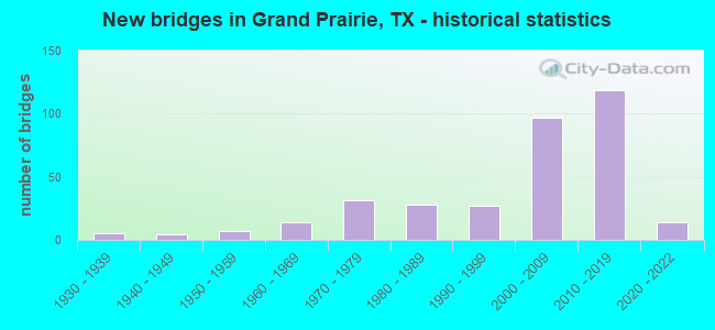
- New bridges - historical statistics
- 51930-1939
- 41940-1949
- 71950-1959
- 141960-1969
- 311970-1979
- 281980-1989
- 271990-1999
- 972000-2009
- 1192010-2019
- 142020-2022
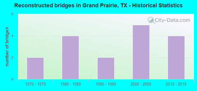
- Reconstructed bridges - Historical Statistics
- 21970-1979
- 41980-1989
- 21990-1999
- 52000-2009
- 42010-2019
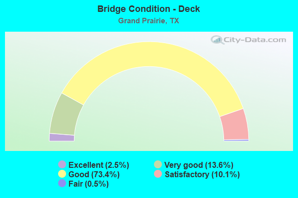
- Bridge Condition - Deck
- 2.5%Excellent
- 13.6%Very good
- 73.4%Good
- 10.1%Satisfactory
- 0.5%Fair
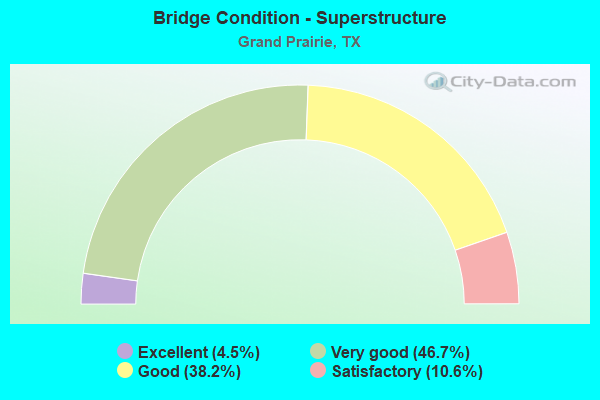
- Bridge Condition - Superstructure
- 4.5%Excellent
- 46.7%Very good
- 38.2%Good
- 10.6%Satisfactory
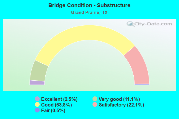
- Bridge Condition - Substructure
- 2.5%Excellent
- 11.1%Very good
- 63.8%Good
- 22.1%Satisfactory
- 0.5%Fair
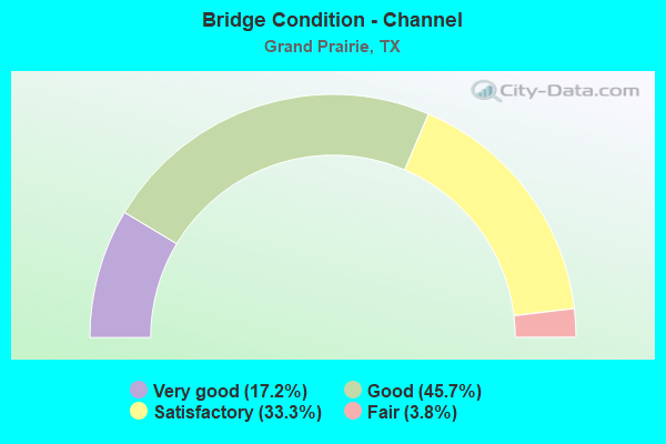
- Bridge Condition - Channel
- 17.2%Very good
- 45.7%Good
- 33.3%Satisfactory
- 3.8%Fair

- Bridge Condition - Culverts
- 3.2%Excellent
- 3.2%Very good
- 51.6%Good
- 38.7%Satisfactory
- 3.2%Fair
Find on map >> Show street view
Structure Number: 180570296401058, Location: 2.00 MI N OF IH 20 (Lat: 32.705617, Lng: -97.025000), Route carried "on" structure: ServiceState highway 161, Year Built: 2006, Status: Open, Structure Length: 0.76m (2.49ft), Average Daily Traffic: 50,000 (year 2015), Truck Traffic: 1%, Average Future Daily Traffic: 90,000 (year 2035), Design Load: HS 20, Features Intersected: DRAIN
Minimum Vertical Clearance: 30+ m (98+ ft), Kilometerpoint: 0.000, Lanes on structure: 3, Toll: On toll road, Owner: State Highway Agency, Maintenance Responsibility: Local Toll Authority, Approaching Roadway Width: 12.8m (42.0ft), Skew: 4 degrees, Material/Design: Concrete, Design/Construction: Culvert, Number Of Spans In Main Unit: 3, Length of Maximum Span: 2.4m (7.9ft)
Condition: Channel: Good, Culverts: Good, Operating Rating: 54.4 metric tons, Method Used To Determine Operating Rating: Assigned rating based on Load Factor Design (LFD) reported in metric tons, Inventory Rating: 32.7 metric tons, Method Used To Determine Inventory Rating: Assigned rating based on Load Factor Design (LFD) reported in metric tons, Structural Evaluation: Better than present minimum criteria, Waterway Adequacy: Equal to present minimum criteria, Approach Roadway Alignment: Equal to present desirable criteria, Designated Inspection Frequency: Every 24 months, Inspection Date: May 2020
Find on map >> Show street view
Structure Number: 180570296401059, Location: 2.20 MI N OF IH 20 (Lat: 32.708350, Lng: -97.025217), Route carried "on" structure: Other road 161, Year Built: 1967, Year Reconstructed: 2012, Status: Open, Structure Length: 1.25m (4.10ft), Average Daily Traffic: 50,000 (year 2015), Truck Traffic: 1%, Average Future Daily Traffic: 90,000 (year 2035), Design Load: HS 20, Features Intersected: TRIB COTTONWOOD CR
Minimum Vertical Clearance: 30+ m (98+ ft), Kilometerpoint: 16.473, Lanes on structure: 11, Toll: On toll road, Owner: State Highway Agency, Maintenance Responsibility: Local Toll Authority, Approaching Roadway Width: 56.1m (184.1ft), Skew: 39 degrees, Material/Design: Concrete, Design/Construction: Culvert, Number Of Spans In Main Unit: 3, Length of Maximum Span: 2.4m (7.9ft), Curb or Sidewalk Widths: Left: 1.5m (4.9ft), Right: 0.0m
Condition: Channel: Satisfactory, Culverts: Satisfactory, Operating Rating: 39.9 metric tons, Method Used To Determine Operating Rating: Load Factor (LF), Inventory Rating: 23.6 metric tons, Method Used To Determine Inventory Rating: Load Factor (LF), Structural Evaluation: Somewhat better than minimum adequacy, Waterway Adequacy: Superior to present desirable criteria, Approach Roadway Alignment: Equal to present desirable criteria, Designated Inspection Frequency: Every 24 months, Inspection Date: May 2020
Find on map >> Show street view
Structure Number: 180570296401061, Location: 0.65 MI S OF IH 30 (Lat: 32.750508, Lng: -97.027700), Route carried "on" structure: ServiceState highway 161, Year Built: 2007, Status: Open, Structure Length: 2.04m (6.69ft), Average Daily Traffic: 4,900 (year 2016), Truck Traffic: 1%, Average Future Daily Traffic: 9,000 (year 2036), Design Load: HS 20, Features Intersected: DALWORTH CREEK
Minimum Vertical Clearance: 30+ m (98+ ft), Kilometerpoint: 47.057, Lanes on structure: 3, Toll: On toll road, Owner: State Highway Agency, Maintenance Responsibility: Local Toll Authority, Approaching Roadway Width: 12.2m (40.0ft), Skew: 4 degrees, Material/Design: Concrete, Design/Construction: Culvert, Number Of Spans In Main Unit: 4, Length of Maximum Span: 3.0m (9.8ft), Out-to-Out Width: 30.2m (99.1ft)
Condition: Channel: Satisfactory, Culverts: Satisfactory, Operating Rating: 54.4 metric tons, Method Used To Determine Operating Rating: No rating analysis performed, Inventory Rating: 32.7 metric tons, Method Used To Determine Inventory Rating: No rating analysis performed, Structural Evaluation: Equal to present minimum criteria, Waterway Adequacy: Superior to present desirable criteria, Approach Roadway Alignment: Equal to present desirable criteria, Designated Inspection Frequency: Every 24 months, Inspection Date: May 2020
Find on map >> Show street view
Structure Number: 180570296401062, Location: 0.65 MI S OF IH 30 (Lat: 32.749867, Lng: -97.028517), Route carried "on" structure: ServiceState highway 161, Year Built: 2008, Status: Open, Structure Length: 1.22m (4.00ft), Average Daily Traffic: 7,100 (year 2016), Truck Traffic: 5%, Average Future Daily Traffic: 13,100 (year 2036), Design Load: HS 20, Features Intersected: DALWORTH CREEK
Minimum Vertical Clearance: 30+ m (98+ ft), Kilometerpoint: 47.073, Lanes on structure: 3, Toll: On toll road, Owner: State Highway Agency, Maintenance Responsibility: Local Toll Authority, Approaching Roadway Width: 12.2m (40.0ft), Skew: 1 degrees, Material/Design: Concrete, Design/Construction: Culvert, Number Of Spans In Main Unit: 4, Length of Maximum Span: 2.4m (7.9ft), Out-to-Out Width: 19.8m (65.0ft)
Condition: Channel: Satisfactory, Culverts: Good, Operating Rating: 54.4 metric tons, Method Used To Determine Operating Rating: No rating analysis performed, Inventory Rating: 32.7 metric tons, Method Used To Determine Inventory Rating: No rating analysis performed, Structural Evaluation: Better than present minimum criteria, Waterway Adequacy: Superior to present desirable criteria, Approach Roadway Alignment: Equal to present desirable criteria, Designated Inspection Frequency: Every 24 months, Inspection Date: May 2020
Find on map >> Show street view
Structure Number: 180570296401065, Location: 0.37 MI N OF IH 30 (Lat: 32.764797, Lng: -97.029369), Route carried "on" structure: City street , Year Built: 2009, Status: Open, Structure Length: 9.11m (29.89ft), Average Daily Traffic: 3,742 (year 2016), Truck Traffic: 13%, Average Future Daily Traffic: 8,195 (year 2036), Design Load: HS 20, Features Intersected: PGBT, Facility Carried by Structure: EGYPTIAN WAY EB
Minimum Vertical Clearance: 30+ m (98+ ft), Kilometerpoint: 0.740, Lanes on structure: 2, Lanes under structure: 7, Owner: Local Toll Authority, Approaching Roadway Width: 7.9m (25.9ft), Skew: 22 degrees, Material/Design: Prestressed concrete, Design/Construction: Stringer/Multi-beam, Number Of Spans In Main Unit: 3, Length of Maximum Span: 32.0m (105.0ft), Curb-To-Curb Width: 7.9m (25.9ft), Out-to-Out Width: 21.0m (68.9ft)
Condition: Deck: Satisfactory, Superstructure: Good, Substructure: Good, Operating Rating: 54.4 metric tons, Method Used To Determine Operating Rating: Assigned rating based on Load Factor Design (LFD) reported in metric tons, Inventory Rating: 32.7 metric tons, Method Used To Determine Inventory Rating: Assigned rating based on Load Factor Design (LFD) reported in metric tons, Structural Evaluation: Better than present minimum criteria, Deck Geometry: High priority of replacement, Underclear: High priority of corrective action, Approach Roadway Alignment: Equal to present desirable criteria, Designated Inspection Frequency: Every 24 months, Inspection Date: April 2020, Deck Structure Type: Concrete Precast Panels
Find on map >> Show street view
Structure Number: 180570296401067, Location: 0.70 MI N OF IH 30 (Lat: 32.769461, Lng: -97.028211), Route carried "on" structure: ServiceState highway 161, Year Built: 2008, Status: Open, Structure Length: 2.32m (7.61ft), Average Daily Traffic: 2,200 (year 2016), Truck Traffic: 5%, Average Future Daily Traffic: 4,200 (year 2036), Design Load: HS 20, Features Intersected: TRIB OF JOHNSON CR
Minimum Vertical Clearance: 30+ m (98+ ft), Kilometerpoint: 34.263, Lanes on structure: 3, Owner: State Highway Agency, Maintenance Responsibility: Local Toll Authority, Approaching Roadway Width: 11.9m (39.0ft), Skew: 4 degrees, Material/Design: Concrete, Design/Construction: Culvert, Number Of Spans In Main Unit: 5, Length of Maximum Span: 3.0m (9.8ft), Curb-To-Curb Width: 12.0m (39.4ft), Out-to-Out Width: 18.0m (59.1ft)
Condition: Channel: Fair, Culverts: Fair, Operating Rating: 54.4 metric tons, Method Used To Determine Operating Rating: Assigned rating based on Load Factor Design (LFD) reported in metric tons, Inventory Rating: 32.7 metric tons, Method Used To Determine Inventory Rating: Assigned rating based on Load Factor Design (LFD) reported in metric tons, Structural Evaluation: Somewhat better than minimum adequacy, Deck Geometry: High priority of replacement, Waterway Adequacy: Superior to present desirable criteria, Approach Roadway Alignment: Equal to present desirable criteria, Designated Inspection Frequency: Every 24 months, Inspection Date: March 2020, Deck Structure Type: Concrete Cast-file-Place, Wearing Surface/Protective System: Wearing Surface: Monolithic Concrete
Find on map >> Show street view
Structure Number: 180570296401069, Location: 0.80 MI N OF IH 30 (Lat: 32.769669, Lng: -97.027164), Route carried "on" structure: ServiceState highway 161, Year Built: 2009, Status: Open, Structure Length: 33.89m (111.19ft), Average Daily Traffic: 16,950 (year 2013), Truck Traffic: 6%, Average Future Daily Traffic: 23,730 (year 2033), Design Load: HS 20, Features Intersected: JOHNSON CR & TRIB
Minimum Vertical Clearance: 30+ m (98+ ft), Kilometerpoint: 33.750, Lanes on structure: 3, Owner: State Highway Agency, Approaching Roadway Width: 12.2m (40.0ft), Skew: 9 degrees, Material/Design: Prestressed concrete, Design/Construction: Stringer/Multi-beam, Number Of Spans In Main Unit: 4, Number Of Approach Spans: 9, Length of Maximum Span: 36.6m (120.1ft), Curb-To-Curb Width: 11.9m (39.0ft), Out-to-Out Width: 12.8m (42.0ft)
Condition: Deck: Good, Superstructure: Very good, Substructure: Good, Channel: Satisfactory, Operating Rating: 54.4 metric tons, Method Used To Determine Operating Rating: Assigned rating based on Load Factor Design (LFD) reported in metric tons, Inventory Rating: 32.7 metric tons, Method Used To Determine Inventory Rating: Assigned rating based on Load Factor Design (LFD) reported in metric tons, Structural Evaluation: Better than present minimum criteria, Deck Geometry: High priority of corrective action, Waterway Adequacy: Superior to present desirable criteria, Approach Roadway Alignment: Equal to present desirable criteria, Designated Inspection Frequency: Every 24 months, Inspection Date: March 2020, Deck Structure Type: Concrete Precast Panels
Find on map >> Show street view
Structure Number: 18057029640107, Location: 0.75 MI N OF IH 30 (Lat: 32.774639, Lng: -97.027944), Route carried "on" structure: ServiceState highway 161, Year Built: 2009, Status: Open, Structure Length: 49.83m (163.48ft), Average Daily Traffic: 16,500 (year 2013), Truck Traffic: 6%, Average Future Daily Traffic: 23,100 (year 2033), Design Load: HS 20, Features Intersected: CARRIER PKY & JOHNSON CR
Minimum Vertical Clearance: 30+ m (98+ ft), Kilometerpoint: 33.682, Lanes on structure: 3, Lanes under structure: 5, Owner: State Highway Agency, Approaching Roadway Width: 12.2m (40.0ft), Skew: 9 degrees, Material/Design: Prestressed concrete, Design/Construction: Stringer/Multi-beam, Number Of Spans In Main Unit: 10, Number Of Approach Spans: 6, Length of Maximum Span: 38.1m (125.0ft), Curb-To-Curb Width: 11.9m (39.0ft), Out-to-Out Width: 12.9m (42.3ft)
Condition: Deck: Good, Superstructure: Good, Substructure: Good, Channel: Very good, Operating Rating: 54.4 metric tons, Method Used To Determine Operating Rating: Assigned rating based on Load Factor Design (LFD) reported in metric tons, Inventory Rating: 32.7 metric tons, Method Used To Determine Inventory Rating: Assigned rating based on Load Factor Design (LFD) reported in metric tons, Structural Evaluation: Better than present minimum criteria, Deck Geometry: High priority of corrective action, Underclear: High priority of corrective action, Waterway Adequacy: Superior to present desirable criteria, Approach Roadway Alignment: Equal to present desirable criteria, Designated Inspection Frequency: Every 24 months, Inspection Date: March 2020, Deck Structure Type: Concrete Precast Panels
Find on map >> Show street view
Structure Number: 180570296401071, Location: 0.66 MI N OF IH 30 (Lat: 32.768942, Lng: -97.027617), Route carried "on" structure: State highway 161, Year Built: 2009, Status: Open, Structure Length: 58.22m (191.01ft), Average Daily Traffic: 35,540 (year 2011), Average Future Daily Traffic: 59,660 (year 2031), Design Load: HS 20, Features Intersected: CARRIER PKY & JOHNSON CR, Facility Carried by Structure: PGBT NBML
Minimum Vertical Clearance: 30+ m (98+ ft), Kilometerpoint: 33.729, Lanes on structure: 4, Lanes under structure: 4, Owner: Local Toll Authority, Approaching Roadway Width: 28.0m (91.9ft), Skew: 9 degrees, Material/Design: Steel continuous, Design/Construction: Stringer/Multi-beam, Number Of Spans In Main Unit: 3, Number Of Approach Spans: 13, Length of Maximum Span: 64.0m (210.0ft), Curb-To-Curb Width: 28.0m (91.9ft), Out-to-Out Width: 29.0m (95.1ft)
Condition: Deck: Good, Superstructure: Very good, Substructure: Good, Channel: Satisfactory, Operating Rating: 54.4 metric tons, Method Used To Determine Operating Rating: Assigned rating based on Load Factor Design (LFD) reported in metric tons, Inventory Rating: 32.7 metric tons, Method Used To Determine Inventory Rating: Assigned rating based on Load Factor Design (LFD) reported in metric tons, Structural Evaluation: Better than present minimum criteria, Deck Geometry: Superior to present desirable criteria, Underclear: Better than present minimum criteria, Waterway Adequacy: Superior to present desirable criteria, Approach Roadway Alignment: Equal to present desirable criteria, Designated Inspection Frequency: Every 24 months, Inspection Date: March 2020, Deck Structure Type: Concrete Cast-file-Place
Find on map >> Show street view
Structure Number: 180570296401072, Location: 0.66 MI N OF IH 30 (Lat: 32.769064, Lng: -97.028086), Route carried "on" structure: State highway 161, Year Built: 2009, Status: Open, Structure Length: 58.22m (191.01ft), Average Daily Traffic: 35,540 (year 2011), Average Future Daily Traffic: 59,660 (year 2031), Design Load: HS 20, Features Intersected: CARRIER PKY & JOHNSON CR, Facility Carried by Structure: PGBT SBML
Minimum Vertical Clearance: 30+ m (98+ ft), Kilometerpoint: 33.729, Lanes on structure: 4, Lanes under structure: 4, Owner: Local Toll Authority, Approaching Roadway Width: 29.3m (96.1ft), Skew: 9 degrees, Material/Design: Steel continuous, Design/Construction: Stringer/Multi-beam, Number Of Spans In Main Unit: 3, Number Of Approach Spans: 13, Length of Maximum Span: 64.0m (210.0ft), Curb-To-Curb Width: 24.4m (80.1ft), Out-to-Out Width: 28.3m (92.8ft)
Condition: Deck: Good, Superstructure: Very good, Substructure: Good, Channel: Satisfactory, Operating Rating: 54.4 metric tons, Method Used To Determine Operating Rating: Assigned rating based on Load Factor Design (LFD) reported in metric tons, Inventory Rating: 32.7 metric tons, Method Used To Determine Inventory Rating: Assigned rating based on Load Factor Design (LFD) reported in metric tons, Structural Evaluation: Better than present minimum criteria, Deck Geometry: Superior to present desirable criteria, Underclear: Equal to present minimum criteria, Waterway Adequacy: Superior to present desirable criteria, Approach Roadway Alignment: Equal to present desirable criteria, Designated Inspection Frequency: Every 24 months, Inspection Date: March 2020, Deck Structure Type: Concrete Cast-file-Place
Find on map >> Show street view
Structure Number: 180570296401073, Location: 1.33 MI N OF IH 30 (Lat: 32.778306, Lng: -97.025944), Route carried "on" structure: State highway 161, Year Built: 2009, Status: Open, Structure Length: 211.74m (694.69ft), Average Daily Traffic: 60,859 (year 2019), Average Future Daily Traffic: 59,660 (year 2031), Design Load: HS 20, Features Intersected: TRINITY R OAKDALE ETC, Facility Carried by Structure: PGBT NBML
Minimum Vertical Clearance: 30+ m (98+ ft), Kilometerpoint: 31.400, Lanes on structure: 3, Lanes under structure: 10, Owner: Local Toll Authority, Approaching Roadway Width: 24.4m (80.1ft), Skew: 9 degrees, Material/Design: Steel continuous, Design/Construction: Stringer/Multi-beam, Number Of Spans In Main Unit: 3, Number Of Approach Spans: 57, Length of Maximum Span: 67.1m (220.1ft), Curb-To-Curb Width: 24.4m (80.1ft), Out-to-Out Width: 25.3m (83.0ft)
Condition: Deck: Good, Superstructure: Very good, Substructure: Good, Channel: Satisfactory, Operating Rating: 54.4 metric tons, Method Used To Determine Operating Rating: Assigned rating based on Load Factor Design (LFD) reported in metric tons, Inventory Rating: 32.7 metric tons, Method Used To Determine Inventory Rating: Assigned rating based on Load Factor Design (LFD) reported in metric tons, Structural Evaluation: Better than present minimum criteria, Deck Geometry: Superior to present desirable criteria, Underclear: Meets minimum limits, Waterway Adequacy: Superior to present desirable criteria, Approach Roadway Alignment: Equal to present desirable criteria, Designated Inspection Frequency: Every 24 months, Inspection Date: March 2020, Deck Structure Type: Concrete Cast-file-Place
Find on map >> Show street view
Structure Number: 180570296401074, Location: 1.33 MI N OF IH 30 (Lat: 32.795583, Lng: -97.018806), Route carried "on" structure: State highway 161, Year Built: 2009, Status: Open, Structure Length: 211.74m (694.69ft), Average Daily Traffic: 68,668 (year 2019), Average Future Daily Traffic: 59,660 (year 2031), Design Load: HS 20, Features Intersected: TRINITY R OAKDALE ETC, Facility Carried by Structure: PGBT SBML
Minimum Vertical Clearance: 30+ m (98+ ft), Kilometerpoint: 31.400, Lanes on structure: 3, Lanes under structure: 10, Owner: Local Toll Authority, Approaching Roadway Width: 20.7m (67.9ft), Skew: 9 degrees, Material/Design: Steel continuous, Design/Construction: Stringer/Multi-beam, Number Of Spans In Main Unit: 3, Number Of Approach Spans: 57, Length of Maximum Span: 67.1m (220.1ft), Curb-To-Curb Width: 20.7m (67.9ft), Out-to-Out Width: 21.6m (70.9ft)
Condition: Deck: Good, Superstructure: Very good, Substructure: Good, Channel: Satisfactory, Operating Rating: 54.4 metric tons, Method Used To Determine Operating Rating: Assigned rating based on Load Factor Design (LFD) reported in metric tons, Inventory Rating: 32.7 metric tons, Method Used To Determine Inventory Rating: Assigned rating based on Load Factor Design (LFD) reported in metric tons, Structural Evaluation: Better than present minimum criteria, Deck Geometry: Superior to present desirable criteria, Underclear: Meets minimum limits, Waterway Adequacy: Superior to present desirable criteria, Approach Roadway Alignment: Equal to present desirable criteria, Designated Inspection Frequency: Every 24 months, Inspection Date: March 2020, Deck Structure Type: Concrete Cast-file-Place
Find on map >> Show street view
Structure Number: 180570296401075, Location: 1.42 MI N OF IH 30 (Lat: 32.779167, Lng: -97.024722), Route carried "on" structure: Ramp State highway 161, Year Built: 2009, Status: Open, Structure Length: 24.23m (79.49ft), Average Daily Traffic: 5,000 (year 2016), Average Future Daily Traffic: 15,000 (year 2036), Design Load: HS 20, Features Intersected: R.O.W., Facility Carried by Structure: PGBT NB ON-RP A
Minimum Vertical Clearance: 30+ m (98+ ft), Kilometerpoint: 31.221, Lanes on structure: 1, Toll: On toll road, Owner: Local Toll Authority, Approaching Roadway Width: 7.0m (23.0ft), Material/Design: Prestressed concrete, Design/Construction: Stringer/Multi-beam, Number Of Spans In Main Unit: 8, Length of Maximum Span: 30.5m (100.1ft), Curb-To-Curb Width: 7.1m (23.3ft), Out-to-Out Width: 9.6m (31.5ft)
Condition: Deck: Good, Superstructure: Very good, Substructure: Good, Operating Rating: 54.4 metric tons, Method Used To Determine Operating Rating: Assigned rating based on Load Factor Design (LFD) reported in metric tons, Inventory Rating: 32.7 metric tons, Method Used To Determine Inventory Rating: Assigned rating based on Load Factor Design (LFD) reported in metric tons, Structural Evaluation: Better than present minimum criteria, Deck Geometry: Equal to present minimum criteria, Approach Roadway Alignment: Equal to present desirable criteria, Designated Inspection Frequency: Every 24 months, Inspection Date: April 2020, Deck Structure Type: Concrete Precast Panels
Find on map >> Show street view
Structure Number: 180570296401076, Location: 1.40 MI N OF IH 30 (Lat: 32.781000, Lng: -97.024361), Route carried "on" structure: Ramp State highway 161, Year Built: 2009, Status: Open, Structure Length: 21.34m (70.01ft), Average Daily Traffic: 7,100 (year 2016), Average Future Daily Traffic: 11,930 (year 2036), Design Load: HS 20, Features Intersected: R.O.W., Facility Carried by Structure: PGBT SB OFF-RP C
Minimum Vertical Clearance: 30+ m (98+ ft), Kilometerpoint: 31.097, Lanes on structure: 2, Toll: On toll road, Owner: Local Toll Authority, Approaching Roadway Width: 10.1m (33.1ft), Material/Design: Prestressed concrete, Design/Construction: Stringer/Multi-beam, Number Of Spans In Main Unit: 7, Length of Maximum Span: 30.5m (100.1ft), Curb-To-Curb Width: 10.1m (33.1ft), Out-to-Out Width: 11.0m (36.1ft)
Condition: Deck: Good, Superstructure: Very good, Substructure: Good, Operating Rating: 54.4 metric tons, Method Used To Determine Operating Rating: Assigned rating based on Load Factor Design (LFD) reported in metric tons, Inventory Rating: 32.7 metric tons, Method Used To Determine Inventory Rating: Assigned rating based on Load Factor Design (LFD) reported in metric tons, Structural Evaluation: Better than present minimum criteria, Deck Geometry: Equal to present minimum criteria, Approach Roadway Alignment: Equal to present desirable criteria, Designated Inspection Frequency: Every 24 months, Inspection Date: April 2020, Deck Structure Type: Concrete Precast Panels
Find on map >> Show street view
Structure Number: 180570296401077, Location: 2.22 MI N OF IH 30 (Lat: 32.789500, Lng: -97.018389), Route carried "on" structure: Ramp State highway 161, Year Built: 2009, Status: Open, Structure Length: 19.35m (63.48ft), Average Daily Traffic: 7,100 (year 2011), Average Future Daily Traffic: 11,930 (year 2031), Design Load: HS 20, Features Intersected: R.O.W., Facility Carried by Structure: PGBT NB OFF-RP F2
Minimum Vertical Clearance: 30+ m (98+ ft), Kilometerpoint: 29.950, Lanes on structure: 1, Toll: On toll road, Owner: Local Toll Authority, Approaching Roadway Width: 7.0m (23.0ft), Material/Design: Prestressed concrete, Design/Construction: Stringer/Multi-beam, Number Of Spans In Main Unit: 6, Length of Maximum Span: 33.5m (109.9ft), Curb-To-Curb Width: 7.1m (23.3ft), Out-to-Out Width: 8.5m (27.9ft)
Condition: Deck: Good, Superstructure: Very good, Substructure: Good, Operating Rating: 54.4 metric tons, Method Used To Determine Operating Rating: Assigned rating based on Load Factor Design (LFD) reported in metric tons, Inventory Rating: 32.7 metric tons, Method Used To Determine Inventory Rating: Assigned rating based on Load Factor Design (LFD) reported in metric tons, Structural Evaluation: Better than present minimum criteria, Deck Geometry: Equal to present minimum criteria, Approach Roadway Alignment: Equal to present desirable criteria, Designated Inspection Frequency: Every 24 months, Inspection Date: April 2020, Deck Structure Type: Concrete Precast Panels
Find on map >> Show street view
Structure Number: 180570296401078, Location: 2.24 MI N OF IH 30 (Lat: 32.791333, Lng: -97.019056), Route carried "on" structure: Ramp State highway 161, Year Built: 2009, Status: Open, Structure Length: 16.15m (52.99ft), Average Daily Traffic: 3,000 (year 2016), Average Future Daily Traffic: 8,000 (year 2036), Design Load: HS 20, Features Intersected: R.O.W., Facility Carried by Structure: PGBT SB ON-RP F
Minimum Vertical Clearance: 30+ m (98+ ft), Kilometerpoint: 29.918, Lanes on structure: 1, Toll: On toll road, Owner: Local Toll Authority, Approaching Roadway Width: 7.6m (24.9ft), Material/Design: Prestressed concrete, Design/Construction: Stringer/Multi-beam, Number Of Spans In Main Unit: 5, Length of Maximum Span: 33.5m (109.9ft), Curb-To-Curb Width: 7.7m (25.3ft), Out-to-Out Width: 9.2m (30.2ft)
Condition: Deck: Good, Superstructure: Good, Substructure: Very good, Operating Rating: 54.4 metric tons, Method Used To Determine Operating Rating: Assigned rating based on Load Factor Design (LFD) reported in metric tons, Inventory Rating: 32.7 metric tons, Method Used To Determine Inventory Rating: Assigned rating based on Load Factor Design (LFD) reported in metric tons, Structural Evaluation: Better than present minimum criteria, Deck Geometry: Better than present minimum criteria, Approach Roadway Alignment: Equal to present desirable criteria, Designated Inspection Frequency: Every 24 months, Inspection Date: April 2020, Deck Structure Type: Concrete Precast Panels
Find on map >> Show street view
Structure Number: 180570296401481, Location: 2.28 MI S OF SH 183 (Lat: 32.803917, Lng: -97.018639), Route carried "on" structure: Other road 161, Year Built: 2009, Status: Open, Structure Length: 63.19m (207.32ft), Average Daily Traffic: 64,100 (year 2016), Average Future Daily Traffic: 94,736 (year 2036), Design Load: HS 20, Features Intersected: TRINITY BLVD SHADY GR, Facility Carried by Structure: PGBT SBML
Minimum Vertical Clearance: 30+ m (98+ ft), Kilometerpoint: 40.773, Lanes on structure: 3, Lanes under structure: 14, Toll: On toll road, Owner: Local Toll Authority, Approaching Roadway Width: 24.4m (80.1ft), Material/Design: Prestressed concrete, Design/Construction: Stringer/Multi-beam, Number Of Spans In Main Unit: 18, Length of Maximum Span: 37.8m (124.0ft), Curb-To-Curb Width: 24.4m (80.1ft), Out-to-Out Width: 25.3m (83.0ft)
Condition: Deck: Good, Superstructure: Very good, Substructure: Good, Operating Rating: 54.4 metric tons, Method Used To Determine Operating Rating: Assigned rating based on Load Factor Design (LFD) reported in metric tons, Inventory Rating: 32.7 metric tons, Method Used To Determine Inventory Rating: Assigned rating based on Load Factor Design (LFD) reported in metric tons, Structural Evaluation: Better than present minimum criteria, Deck Geometry: Superior to present desirable criteria, Underclear: Equal to present minimum criteria, Approach Roadway Alignment: Equal to present desirable criteria, Designated Inspection Frequency: Every 24 months, Inspection Date: March 2020, Deck Structure Type: Concrete Precast Panels
Find on map >> Show street view
Structure Number: 180570296401482, Location: 2.28 MI S OF SH 183 (Lat: 32.798222, Lng: -97.018167), Route carried "on" structure: Other road 161, Year Built: 2009, Status: Open, Structure Length: 63.19m (207.32ft), Average Daily Traffic: 156,000 (year 2016), Average Future Daily Traffic: 94,736 (year 2036), Design Load: HS 20, Features Intersected: TRINITY BLVD SHADY GR
Minimum Vertical Clearance: 30+ m (98+ ft), Kilometerpoint: 40.773, Lanes on structure: 3, Lanes under structure: 14, Toll: On toll road, Owner: Local Toll Authority, Approaching Roadway Width: 24.4m (80.1ft), Material/Design: Prestressed concrete, Design/Construction: Stringer/Multi-beam, Number Of Spans In Main Unit: 18, Length of Maximum Span: 37.8m (124.0ft), Curb-To-Curb Width: 24.4m (80.1ft), Out-to-Out Width: 25.3m (83.0ft)
Condition: Deck: Good, Superstructure: Very good, Substructure: Good, Operating Rating: 54.4 metric tons, Method Used To Determine Operating Rating: Assigned rating based on Load Factor Design (LFD) reported in metric tons, Inventory Rating: 32.7 metric tons, Method Used To Determine Inventory Rating: Assigned rating based on Load Factor Design (LFD) reported in metric tons, Structural Evaluation: Better than present minimum criteria, Deck Geometry: Superior to present desirable criteria, Underclear: Equal to present minimum criteria, Approach Roadway Alignment: Equal to present desirable criteria, Designated Inspection Frequency: Every 24 months, Inspection Date: March 2020, Deck Structure Type: Concrete Precast Panels
Find on map >> Show street view
Structure Number: 180570296401484, Location: 1.40 MI SOUTH OF SH 183 (Lat: 32.808528, Lng: -97.017972), Route carried "on" structure: Other road 161, Year Built: 2009, Status: Open, Structure Length: 188.76m (619.29ft), Average Daily Traffic: 156,000 (year 2016), Average Future Daily Traffic: 204,731 (year 2036), Design Load: HS 20, Features Intersected: ROCK ISLAND RD BEAR CR
Minimum Vertical Clearance: 30+ m (98+ ft), Kilometerpoint: 39.524, Lanes on structure: 3, Lanes under structure: 9, Toll: On toll road, Owner: Local Toll Authority, Approaching Roadway Width: 25.6m (84.0ft), Skew: 2 degrees, Material/Design: Prestressed concrete, Design/Construction: Stringer/Multi-beam, Number Of Spans In Main Unit: 37, Number Of Approach Spans: 17, Length of Maximum Span: 46.6m (152.9ft), Curb-To-Curb Width: 24.4m (80.1ft), Out-to-Out Width: 25.3m (83.0ft)
Condition: Deck: Good, Superstructure: Good, Substructure: Good, Channel: Satisfactory, Operating Rating: 54.4 metric tons, Method Used To Determine Operating Rating: Assigned rating based on Load Factor Design (LFD) reported in metric tons, Inventory Rating: 32.7 metric tons, Method Used To Determine Inventory Rating: Assigned rating based on Load Factor Design (LFD) reported in metric tons, Structural Evaluation: Better than present minimum criteria, Deck Geometry: Superior to present desirable criteria, Underclear: High priority of corrective action, Waterway Adequacy: Superior to present desirable criteria, Approach Roadway Alignment: Equal to present desirable criteria, Designated Inspection Frequency: Every 24 months, Inspection Date: March 2020, Deck Structure Type: Concrete Precast Panels
Find on map >> Show street view
Structure Number: 180570296401495, Location: IH20 / SH161 INTERCHANGE (Lat: 32.675575, Lng: -97.027936), Route carried "on" structure: Ramp State highway 161, Year Built: 2012, Status: Open, Structure Length: 96.26m (315.81ft), Average Daily Traffic: 15,000 (year 2015), Truck Traffic: 5%, Average Future Daily Traffic: 22,300 (year 2035), Design Load: HL 93, Features Intersected: IH 20 SH 161 FISH CRK
Minimum Vertical Clearance: 30+ m (98+ ft), Kilometerpoint: 8.100, Lanes on structure: 2, Lanes under structure: 29, Toll: On toll road, Owner: State Highway Agency, Approaching Roadway Width: 11.0m (36.1ft), Skew: 9 degrees, Material/Design: Steel continuous, Design/Construction: Stringer/Multi-beam, Number Of Spans In Main Unit: 2, Number Of Approach Spans: 22, Length of Maximum Span: 85.6m (280.8ft), Curb-To-Curb Width: 11.0m (36.1ft), Out-to-Out Width: 11.6m (38.1ft)
Condition: Deck: Good, Superstructure: Very good, Substructure: Good, Channel: Very good, Operating Rating: 54.4 metric tons, Method Used To Determine Operating Rating: Assigned ratings based on Load and Resistance Factor Design (LRFD) reported in metric tons, Inventory Rating: 32.7 metric tons, Method Used To Determine Inventory Rating: Assigned ratings based on Load and Resistance Factor Design (LRFD) reported in metric tons, Structural Evaluation: Better than present minimum criteria, Deck Geometry: Better than present minimum criteria, Underclear: Equal to present minimum criteria, Waterway Adequacy: Superior to present desirable criteria, Approach Roadway Alignment: Equal to present desirable criteria, Designated Inspection Frequency: Every 24 months, Inspection Date: May 2020, Deck Structure Type: Concrete Cast-file-Place
Find on map >> Show street view
Structure Number: 180570296401496, Location: IH20 / SH161 INTERCHANGE (Lat: 32.677261, Lng: -97.025058), Route carried "on" structure: Ramp State highway 161, Year Built: 2012, Status: Open, Structure Length: 69.80m (229.00ft), Average Daily Traffic: 15,000 (year 2015), Truck Traffic: 5%, Average Future Daily Traffic: 22,300 (year 2035), Design Load: HL 93, Features Intersected: IH 20 WBFR & SH 161 SBFR
Minimum Vertical Clearance: 30+ m (98+ ft), Kilometerpoint: 0.000, Lanes on structure: 2, Lanes under structure: 6, Toll: On toll road, Owner: State Highway Agency, Approaching Roadway Width: 11.0m (36.1ft), Skew: 9 degrees, Material/Design: Prestressed concrete, Design/Construction: Stringer/Multi-beam, Number Of Spans In Main Unit: 16, Number Of Approach Spans: 4, Length of Maximum Span: 41.1m (134.8ft), Curb-To-Curb Width: 11.0m (36.1ft), Out-to-Out Width: 11.6m (38.1ft)
Condition: Deck: Good, Superstructure: Very good, Substructure: Good, Channel: Very good, Operating Rating: 54.4 metric tons, Method Used To Determine Operating Rating: Assigned ratings based on Load and Resistance Factor Design (LRFD) reported in metric tons, Inventory Rating: 32.7 metric tons, Method Used To Determine Inventory Rating: Assigned ratings based on Load and Resistance Factor Design (LRFD) reported in metric tons, Structural Evaluation: Better than present minimum criteria, Deck Geometry: Better than present minimum criteria, Underclear: High priority of corrective action, Waterway Adequacy: Superior to present desirable criteria, Approach Roadway Alignment: Equal to present desirable criteria, Designated Inspection Frequency: Every 24 months, Inspection Date: May 2020, Deck Structure Type: Concrete Precast Panels
Find on map >> Show street view
Structure Number: 180570296401497, Location: IH20 SH161 INTERCHANGE (Lat: 32.682075, Lng: -97.024425), Route carried "on" structure: Ramp State highway 161, Year Built: 2012, Status: Open, Structure Length: 95.52m (313.39ft), Average Daily Traffic: 15,000 (year 2015), Truck Traffic: 1%, Average Future Daily Traffic: 19,700 (year 2035), Design Load: HL 93, Features Intersected: IH 20 SH 161 FISH CRK
Minimum Vertical Clearance: 5.16m (16.93ft), Kilometerpoint: 0.000, Lanes on structure: 2, Lanes under structure: 25, Toll: On toll road, Owner: State Highway Agency, Approaching Roadway Width: 11.0m (36.1ft), Skew: 9 degrees, Material/Design: Steel continuous, Design/Construction: Stringer/Multi-beam, Number Of Spans In Main Unit: 2, Number Of Approach Spans: 23, Length of Maximum Span: 75.6m (248.0ft), Curb-To-Curb Width: 11.0m (36.1ft), Out-to-Out Width: 11.6m (38.1ft)
Condition: Deck: Good, Superstructure: Very good, Substructure: Good, Channel: Good, Operating Rating: 54.4 metric tons, Method Used To Determine Operating Rating: Assigned ratings based on Load and Resistance Factor Design (LRFD) reported in metric tons, Inventory Rating: 32.7 metric tons, Method Used To Determine Inventory Rating: Assigned ratings based on Load and Resistance Factor Design (LRFD) reported in metric tons, Structural Evaluation: Better than present minimum criteria, Deck Geometry: Better than present minimum criteria, Underclear: Equal to present minimum criteria, Waterway Adequacy: Superior to present desirable criteria, Approach Roadway Alignment: Equal to present desirable criteria, Designated Inspection Frequency: Every 24 months, Inspection Date: May 2020, Deck Structure Type: Concrete Cast-file-Place
Find on map >> Show street view
Structure Number: 180570296401498, Location: IH20 / SH161 INTERCHANGE (Lat: 32.676383, Lng: -97.019897), Route carried "on" structure: Ramp State highway 161, Year Built: 2012, Status: Open, Structure Length: 61.60m (202.10ft), Average Daily Traffic: 15,000 (year 2015), Truck Traffic: 1%, Average Future Daily Traffic: 20,000 (year 2035), Design Load: HL 93, Features Intersected: IH 20 WBFR & SH 161 NBFR
Minimum Vertical Clearance: 30+ m (98+ ft), Kilometerpoint: 0.000, Lanes on structure: 2, Lanes under structure: 6, Toll: On toll road, Owner: State Highway Agency, Approaching Roadway Width: 11.0m (36.1ft), Skew: 9 degrees, Material/Design: Prestressed concrete, Design/Construction: Stringer/Multi-beam, Number Of Spans In Main Unit: 17, Length of Maximum Span: 41.5m (136.2ft), Curb-To-Curb Width: 11.0m (36.1ft), Out-to-Out Width: 11.6m (38.1ft)
Condition: Deck: Good, Superstructure: Very good, Substructure: Good, Channel: Very good, Operating Rating: 54.4 metric tons, Method Used To Determine Operating Rating: Assigned ratings based on Load and Resistance Factor Design (LRFD) reported in metric tons, Inventory Rating: 32.7 metric tons, Method Used To Determine Inventory Rating: Assigned ratings based on Load and Resistance Factor Design (LRFD) reported in metric tons, Structural Evaluation: Better than present minimum criteria, Deck Geometry: Better than present minimum criteria, Underclear: High priority of corrective action, Waterway Adequacy: Superior to present desirable criteria, Approach Roadway Alignment: Equal to present desirable criteria, Designated Inspection Frequency: Every 24 months, Inspection Date: May 2020, Deck Structure Type: Concrete Precast Panels
Find on map >> Show street view
Structure Number: 180570296401501, Location: 2.88 MI S OF IH 30 (Lat: 32.721383, Lng: -97.022758), Route carried "on" structure: Other road 161, Year Built: 2012, Status: Open, Structure Length: 6.34m (20.80ft), Average Daily Traffic: 10,000 (year 2013), Truck Traffic: 1%, Average Future Daily Traffic: 56,900 (year 2030), Design Load: HL 93, Features Intersected: W MARSHALL DR, Facility Carried by Structure: PGBT SB
Minimum Vertical Clearance: 30+ m (98+ ft), Kilometerpoint: 50.614, Lanes on structure: 2, Lanes under structure: 6, Toll: On toll road, Owner: Local Toll Authority, Approaching Roadway Width: 14.0m (45.9ft), Skew: 2 degrees, Material/Design: Prestressed concrete, Design/Construction: Stringer/Multi-beam, Number Of Spans In Main Unit: 1, Number Of Approach Spans: 2, Length of Maximum Span: 30.5m (100.1ft), Curb-To-Curb Width: 20.7m (67.9ft), Out-to-Out Width: 22.7m (74.5ft)
Condition: Deck: Good, Superstructure: Very good, Substructure: Good, Operating Rating: 54.4 metric tons, Method Used To Determine Operating Rating: Assigned ratings based on Load and Resistance Factor Design (LRFD) reported in metric tons, Inventory Rating: 32.7 metric tons, Method Used To Determine Inventory Rating: Assigned ratings based on Load and Resistance Factor Design (LRFD) reported in metric tons, Structural Evaluation: Better than present minimum criteria, Deck Geometry: Superior to present desirable criteria, Underclear: Somewhat better than minimum adequacy, Approach Roadway Alignment: Equal to present desirable criteria, Designated Inspection Frequency: Every 24 months, Inspection Date: May 2020, Deck Structure Type: Concrete Precast Panels
Find on map >> Show street view
Structure Number: 180570296401502, Location: 2.88 MI S OF IH 30 (Lat: 32.720875, Lng: -97.022528), Route carried "on" structure: Other road 161, Year Built: 2012, Status: Open, Structure Length: 6.34m (20.80ft), Average Daily Traffic: 10,000 (year 2012), Truck Traffic: 1%, Average Future Daily Traffic: 56,900 (year 2030), Design Load: HL 93, Features Intersected: W MARSHALL DR, Facility Carried by Structure: PGBT NB
Minimum Vertical Clearance: 30+ m (98+ ft), Kilometerpoint: 50.614, Lanes on structure: 2, Lanes under structure: 6, Toll: On toll road, Owner: Local Toll Authority, Approaching Roadway Width: 15.9m (52.2ft), Skew: 32 degrees, Material/Design: Prestressed concrete, Design/Construction: Stringer/Multi-beam, Number Of Spans In Main Unit: 1, Number Of Approach Spans: 2, Length of Maximum Span: 30.5m (100.1ft), Curb-To-Curb Width: 14.6m (47.9ft), Out-to-Out Width: 23.4m (76.8ft)
Condition: Deck: Good, Superstructure: Very good, Substructure: Good, Operating Rating: 54.4 metric tons, Method Used To Determine Operating Rating: Assigned ratings based on Load and Resistance Factor Design (LRFD) reported in metric tons, Inventory Rating: 32.7 metric tons, Method Used To Determine Inventory Rating: Assigned ratings based on Load and Resistance Factor Design (LRFD) reported in metric tons, Structural Evaluation: Better than present minimum criteria, Deck Geometry: Superior to present desirable criteria, Underclear: Somewhat better than minimum adequacy, Approach Roadway Alignment: Equal to present desirable criteria, Designated Inspection Frequency: Every 24 months, Inspection Date: May 2020, Deck Structure Type: Concrete Precast Panels
Find on map >> Show street view
Structure Number: 180570296401503, Location: 2.30 MI S OF IH 30 (Lat: 32.729233, Lng: -97.019683), Route carried "on" structure: Other road 161, Year Built: 2012, Status: Open, Structure Length: 22.65m (74.31ft), Average Daily Traffic: 10,000 (year 2012), Truck Traffic: 1%, Average Future Daily Traffic: 63,000 (year 2030), Design Load: HL 93, Features Intersected: SW 14TH & COTTONWOOD CR, Facility Carried by Structure: PGBT SB
Minimum Vertical Clearance: 30+ m (98+ ft), Kilometerpoint: 49.680, Lanes on structure: 3, Lanes under structure: 4, Toll: On toll road, Owner: Local Toll Authority, Approaching Roadway Width: 17.4m (57.1ft), Skew: 9 degrees, Material/Design: Prestressed concrete, Design/Construction: Stringer/Multi-beam, Number Of Spans In Main Unit: 5, Number Of Approach Spans: 2, Length of Maximum Span: 40.8m (133.9ft), Curb-To-Curb Width: 24.4m (80.1ft), Out-to-Out Width: 25.0m (82.0ft)
Condition: Deck: Good, Superstructure: Good, Substructure: Good, Channel: Satisfactory, Operating Rating: 54.4 metric tons, Method Used To Determine Operating Rating: Assigned ratings based on Load and Resistance Factor Design (LRFD) reported in metric tons, Inventory Rating: 32.7 metric tons, Method Used To Determine Inventory Rating: Assigned ratings based on Load and Resistance Factor Design (LRFD) reported in metric tons, Structural Evaluation: Better than present minimum criteria, Deck Geometry: Superior to present desirable criteria, Underclear: Meets minimum limits, Waterway Adequacy: Superior to present desirable criteria, Approach Roadway Alignment: Equal to present desirable criteria, Designated Inspection Frequency: Every 24 months, Inspection Date: May 2020, Deck Structure Type: Concrete Precast Panels
Find on map >> Show street view
Structure Number: 180570296401504, Location: 2.30 MI S OF IH 30 (Lat: 32.727292, Lng: -97.019956), Route carried "on" structure: Other road 161, Year Built: 2012, Status: Open, Structure Length: 22.65m (74.31ft), Average Daily Traffic: 10,000 (year 2012), Truck Traffic: 1%, Average Future Daily Traffic: 63,000 (year 2030), Design Load: HL 93, Features Intersected: SW 14TH & COTTONWOOD CR, Facility Carried by Structure: PGBT NB
Minimum Vertical Clearance: 30+ m (98+ ft), Kilometerpoint: 49.680, Lanes on structure: 3, Lanes under structure: 4, Toll: On toll road, Owner: Local Toll Authority, Approaching Roadway Width: 17.4m (57.1ft), Skew: 9 degrees, Material/Design: Prestressed concrete, Design/Construction: Stringer/Multi-beam, Number Of Spans In Main Unit: 5, Number Of Approach Spans: 2, Length of Maximum Span: 40.8m (133.9ft), Curb-To-Curb Width: 24.4m (80.1ft), Out-to-Out Width: 25.0m (82.0ft)
Condition: Deck: Good, Superstructure: Very good, Substructure: Good, Channel: Satisfactory, Operating Rating: 54.4 metric tons, Method Used To Determine Operating Rating: Assigned ratings based on Load and Resistance Factor Design (LRFD) reported in metric tons, Inventory Rating: 32.7 metric tons, Method Used To Determine Inventory Rating: Assigned ratings based on Load and Resistance Factor Design (LRFD) reported in metric tons, Structural Evaluation: Better than present minimum criteria, Deck Geometry: Superior to present desirable criteria, Underclear: Meets minimum limits, Waterway Adequacy: Superior to present desirable criteria, Approach Roadway Alignment: Equal to present desirable criteria, Designated Inspection Frequency: Every 24 months, Inspection Date: May 2020, Deck Structure Type: Concrete Precast Panels
Find on map >> Show street view
Structure Number: 180570296401505, Location: 1.47 MI S OF IH 30 (Lat: 32.740767, Lng: -97.020250), Route carried "on" structure: City street , Year Built: 2012, Status: Open, Structure Length: 4.57m (14.99ft), Average Daily Traffic: 10,000 (year 2016), Truck Traffic: 2%, Average Future Daily Traffic: 15,000 (year 2036), Design Load: HL 93, Features Intersected: PGBT, Facility Carried by Structure: W JEFFERSON ST
Minimum Vertical Clearance: 30+ m (98+ ft), Kilometerpoint: 1.432, Lanes on structure: 8, Lanes under structure: 4, Toll: On toll road, Owner: Local Toll Authority, Approaching Roadway Width: 20.7m (67.9ft), Skew: 10 degrees, Material/Design: Prestressed concrete, Design/Construction: Stringer/Multi-beam, Number Of Spans In Main Unit: 2, Length of Maximum Span: 22.9m (75.1ft), Curb-To-Curb Width: 28.3m (92.8ft), Out-to-Out Width: 40.9m (134.2ft)
Condition: Deck: Very good, Superstructure: Very good, Substructure: Good, Operating Rating: 54.4 metric tons, Method Used To Determine Operating Rating: Assigned ratings based on Load and Resistance Factor Design (LRFD) reported in metric tons, Inventory Rating: 32.7 metric tons, Method Used To Determine Inventory Rating: Assigned ratings based on Load and Resistance Factor Design (LRFD) reported in metric tons, Structural Evaluation: Better than present minimum criteria, Deck Geometry: High priority of replacement, Underclear: Meets minimum limits, Approach Roadway Alignment: Equal to present desirable criteria, Designated Inspection Frequency: Every 24 months, Inspection Date: May 2020, Deck Structure Type: Concrete Precast Panels
Find on map >> Show street view
Structure Number: 180570296401506, Location: 1.41 MI S OF IH 30 (Lat: 32.741983, Lng: -97.019967), Route carried "on" structure: City street , Year Built: 2012, Status: Open, Structure Length: 4.63m (15.19ft), Average Daily Traffic: 12,401 (year 2016), Truck Traffic: 5%, Average Future Daily Traffic: 28,900 (year 2036), Design Load: HL 93, Features Intersected: SH 161, Facility Carried by Structure: W MAIN ST
Minimum Vertical Clearance: 30+ m (98+ ft), Kilometerpoint: 1.416, Lanes on structure: 6, Lanes under structure: 4, Toll: On toll road, Owner: Local Toll Authority, Approaching Roadway Width: 15.2m (49.9ft), Skew: 10 degrees, Material/Design: Prestressed concrete, Design/Construction: Stringer/Multi-beam, Number Of Spans In Main Unit: 2, Length of Maximum Span: 23.5m (77.1ft), Curb-To-Curb Width: 21.9m (71.9ft), Out-to-Out Width: 34.6m (113.5ft)
Condition: Deck: Good, Superstructure: Good, Substructure: Satisfactory, Operating Rating: 54.4 metric tons, Method Used To Determine Operating Rating: Assigned ratings based on Load and Resistance Factor Design (LRFD) reported in metric tons, Inventory Rating: 32.7 metric tons, Method Used To Determine Inventory Rating: Assigned ratings based on Load and Resistance Factor Design (LRFD) reported in metric tons, Structural Evaluation: Equal to present minimum criteria, Deck Geometry: High priority of corrective action, Underclear: Meets minimum limits, Approach Roadway Alignment: Equal to present desirable criteria, Designated Inspection Frequency: Every 24 months, Inspection Date: May 2020, Deck Structure Type: Concrete Precast Panels
Find on map >> Show street view
Structure Number: 180570296401507, Location: 1.20 MI S OF IH 30 (Lat: 32.744533, Lng: -97.021850), Route carried "on" structure: City street , Year Built: 2012, Status: Open, Structure Length: 5.58m (18.31ft), Average Daily Traffic: 4,577 (year 2019), Truck Traffic: 5%, Average Future Daily Traffic: 9,200 (year 2036), Design Load: HL 93, Features Intersected: PGBT, Facility Carried by Structure: DALWORTH ST
Minimum Vertical Clearance: 30+ m (98+ ft), Kilometerpoint: 1.304, Lanes on structure: 4, Lanes under structure: 4, Toll: On toll road, Owner: Local Toll Authority, Approaching Roadway Width: 12.2m (40.0ft), Skew: 13 degrees, Material/Design: Prestressed concrete, Design/Construction: Stringer/Multi-beam, Number Of Spans In Main Unit: 2, Length of Maximum Span: 28.0m (91.9ft), Curb or Sidewalk Widths: Left: 0.0m, Right: 1.7m (5.6ft), Curb-To-Curb Width: 14.4m (47.2ft), Out-to-Out Width: 28.4m (93.2ft)
Condition: Deck: Good, Superstructure: Very good, Substructure: Good, Operating Rating: 54.4 metric tons, Method Used To Determine Operating Rating: Assigned ratings based on Load and Resistance Factor Design (LRFD) reported in metric tons, Inventory Rating: 32.7 metric tons, Method Used To Determine Inventory Rating: Assigned ratings based on Load and Resistance Factor Design (LRFD) reported in metric tons, Structural Evaluation: Better than present minimum criteria, Deck Geometry: High priority of replacement, Underclear: Meets minimum limits, Approach Roadway Alignment: Equal to present desirable criteria, Designated Inspection Frequency: Every 24 months, Inspection Date: May 2020, Deck Structure Type: Concrete Precast Panels
Find on map >> Show street view
Structure Number: 180570296401508, Location: 0.55 MI S OF IH 30 (Lat: 32.751497, Lng: -97.028986), Route carried "on" structure: Other road 161, Year Built: 2012, Status: Open, Structure Length: 23.47m (77.00ft), Average Daily Traffic: 10,000 (year 2016), Truck Traffic: 1%, Average Future Daily Traffic: 65,300 (year 2036), Design Load: HL 93, Features Intersected: JANUARY LN & DALWORTH CR, Facility Carried by Structure: PGBT SBML
Minimum Vertical Clearance: 30+ m (98+ ft), Kilometerpoint: 46.912, Lanes on structure: 3, Lanes under structure: 4, Toll: On toll road, Owner: Local Toll Authority, Approaching Roadway Width: 22.6m (74.1ft), Skew: 9 degrees, Material/Design: Prestressed concrete, Design/Construction: Stringer/Multi-beam, Number Of Spans In Main Unit: 2, Number Of Approach Spans: 6, Length of Maximum Span: 42.1m (138.1ft), Curb-To-Curb Width: 24.4m (80.1ft), Out-to-Out Width: 28.0m (91.9ft)
Condition: Deck: Good, Superstructure: Very good, Substructure: Good, Channel: Very good, Operating Rating: 54.4 metric tons, Method Used To Determine Operating Rating: Assigned ratings based on Load and Resistance Factor Design (LRFD) reported in metric tons, Inventory Rating: 32.7 metric tons, Method Used To Determine Inventory Rating: Assigned ratings based on Load and Resistance Factor Design (LRFD) reported in metric tons, Structural Evaluation: Better than present minimum criteria, Deck Geometry: Superior to present desirable criteria, Underclear: Meets minimum limits, Waterway Adequacy: Superior to present desirable criteria, Approach Roadway Alignment: Equal to present desirable criteria, Designated Inspection Frequency: Every 24 months, Inspection Date: May 2020, Deck Structure Type: Concrete Precast Panels
Find on map >> Show street view
Structure Number: 180570296401509, Location: 0.55 MI S OF IH 30 (Lat: 32.749833, Lng: -97.027547), Route carried "on" structure: Other road 161, Year Built: 2012, Status: Open, Structure Length: 22.52m (73.88ft), Average Daily Traffic: 10,000 (year 2016), Truck Traffic: 1%, Average Future Daily Traffic: 65,300 (year 2036), Design Load: HL 93, Features Intersected: JANUARY LN & DALWORTH CR, Facility Carried by Structure: PGBT NBML
Minimum Vertical Clearance: 30+ m (98+ ft), Kilometerpoint: 46.912, Lanes on structure: 3, Lanes under structure: 4, Toll: On toll road, Owner: Local Toll Authority, Approaching Roadway Width: 16.5m (54.1ft), Skew: 9 degrees, Material/Design: Prestressed concrete, Design/Construction: Stringer/Multi-beam, Number Of Spans In Main Unit: 3, Number Of Approach Spans: 4, Length of Maximum Span: 43.0m (141.1ft), Curb-To-Curb Width: 16.5m (54.1ft), Out-to-Out Width: 29.5m (96.8ft)
Condition: Deck: Good, Superstructure: Very good, Substructure: Good, Channel: Very good, Operating Rating: 54.4 metric tons, Method Used To Determine Operating Rating: Assigned ratings based on Load and Resistance Factor Design (LRFD) reported in metric tons, Inventory Rating: 32.7 metric tons, Method Used To Determine Inventory Rating: Assigned ratings based on Load and Resistance Factor Design (LRFD) reported in metric tons, Structural Evaluation: Better than present minimum criteria, Deck Geometry: Equal to present minimum criteria, Underclear: Meets minimum limits, Waterway Adequacy: Superior to present desirable criteria, Approach Roadway Alignment: Equal to present desirable criteria, Designated Inspection Frequency: Every 24 months, Inspection Date: May 2020, Deck Structure Type: Concrete Precast Panels
Find on map >> Show street view
Structure Number: 18057029640151, Location: 0.16 MI S OF IH 30 (Lat: 32.756900, Lng: -97.029450), Route carried "on" structure: City street , Year Built: 2012, Status: Open, Structure Length: 5.30m (17.39ft), Average Daily Traffic: 6,612 (year 2016), Truck Traffic: 2%, Average Future Daily Traffic: 21,000 (year 2036), Design Load: HL 93, Features Intersected: PGBT, Facility Carried by Structure: W TARRANT RD
Minimum Vertical Clearance: 30+ m (98+ ft), Kilometerpoint: 0.547, Lanes on structure: 6, Lanes under structure: 5, Owner: Local Toll Authority, Approaching Roadway Width: 20.7m (67.9ft), Skew: 10 degrees, Material/Design: Prestressed concrete, Design/Construction: Stringer/Multi-beam, Number Of Spans In Main Unit: 2, Length of Maximum Span: 29.9m (98.1ft), Curb or Sidewalk Widths: Left: 2.0m (6.6ft), Right: 0.0m, Curb-To-Curb Width: 20.7m (67.9ft), Out-to-Out Width: 33.7m (110.6ft)
Condition: Deck: Good, Superstructure: Very good, Substructure: Good, Operating Rating: 44.4 metric tons, Method Used To Determine Operating Rating: Assigned ratings based on Load and Resistance Factor Design (LRFD) reported in metric tons, Inventory Rating: 32.7 metric tons, Method Used To Determine Inventory Rating: Assigned ratings based on Load and Resistance Factor Design (LRFD) reported in metric tons, Structural Evaluation: Better than present minimum criteria, Deck Geometry: High priority of replacement, Underclear: Meets minimum limits, Approach Roadway Alignment: Equal to present desirable criteria, Designated Inspection Frequency: Every 24 months, Inspection Date: May 2020, Deck Structure Type: Concrete Precast Panels
Find on map >> Show street view
Structure Number: 180570296401511, Location: IH 30 & SH 161 I/C (Lat: 32.756711, Lng: -97.028614), Route carried "on" structure: Ramp State highway 161, Year Built: 2013, Status: Open, Structure Length: 67.42m (221.19ft), Average Daily Traffic: 10,000 (year 2016), Truck Traffic: 1%, Average Future Daily Traffic: 21,200 (year 2036), Design Load: HL 93, Features Intersected: IH 30 & SH 161 I/C, Facility Carried by Structure: PGBT NB CONN G
Minimum Vertical Clearance: 30+ m (98+ ft), Kilometerpoint: 46.446, Lanes on structure: 1, Lanes under structure: 22, Owner: Local Toll Authority, Approaching Roadway Width: 11.0m (36.1ft), Skew: 9 degrees, Material/Design: Steel continuous, Design/Construction: Stringer/Multi-beam, Number Of Spans In Main Unit: 4, Number Of Approach Spans: 11, Length of Maximum Span: 70.7m (232.0ft), Curb-To-Curb Width: 8.5m (27.9ft), Out-to-Out Width: 10.4m (34.1ft)
Condition: Deck: Satisfactory, Superstructure: Very good, Substructure: Satisfactory, Operating Rating: 54.4 metric tons, Method Used To Determine Operating Rating: Assigned ratings based on Load and Resistance Factor Design (LRFD) reported in metric tons, Inventory Rating: 32.7 metric tons, Method Used To Determine Inventory Rating: Assigned ratings based on Load and Resistance Factor Design (LRFD) reported in metric tons, Structural Evaluation: Equal to present minimum criteria, Deck Geometry: Superior to present desirable criteria, Underclear: Meets minimum limits, Approach Roadway Alignment: Equal to present desirable criteria, Designated Inspection Frequency: Every 24 months, Inspection Date: May 2020, Deck Structure Type: Concrete Cast-file-Place
Find on map >> Show street view
Structure Number: 180570296401512, Location: IH 30 & SH 161 I/C (Lat: 32.758167, Lng: -97.028567), Route carried "on" structure: Ramp State highway 161, Year Built: 2012, Status: Open, Structure Length: 21.31m (69.91ft), Average Daily Traffic: 10,000 (year 2016), Truck Traffic: 1%, Average Future Daily Traffic: 12,000 (year 2036), Design Load: HL 93, Features Intersected: SH 161 NBFR & IH 30 EBFR
Minimum Vertical Clearance: 30+ m (98+ ft), Kilometerpoint: 46.317, Lanes on structure: 1, Lanes under structure: 3, Owner: Local Toll Authority, Approaching Roadway Width: 8.8m (28.9ft), Skew: 9 degrees, Material/Design: Prestressed concrete, Design/Construction: Stringer/Multi-beam, Number Of Spans In Main Unit: 8, Length of Maximum Span: 28.0m (91.9ft), Curb-To-Curb Width: 8.8m (28.9ft), Out-to-Out Width: 9.4m (30.8ft)
Condition: Deck: Good, Superstructure: Very good, Substructure: Good, Operating Rating: 54.4 metric tons, Method Used To Determine Operating Rating: Assigned ratings based on Load and Resistance Factor Design (LRFD) reported in metric tons, Inventory Rating: 32.7 metric tons, Method Used To Determine Inventory Rating: Assigned ratings based on Load and Resistance Factor Design (LRFD) reported in metric tons, Structural Evaluation: Better than present minimum criteria, Deck Geometry: Superior to present desirable criteria, Underclear: Meets minimum limits, Approach Roadway Alignment: Equal to present desirable criteria, Designated Inspection Frequency: Every 24 months, Inspection Date: May 2020, Deck Structure Type: Concrete Precast Panels
Find on map >> Show street view
Structure Number: 180570296401521, Location: IH 30 & SH 161 I/C (Lat: 32.760767, Lng: -97.030058), Route carried "on" structure: ServiceState highway 161, Year Built: 2012, Status: Open, Structure Length: 6.04m (19.82ft), Average Daily Traffic: 4,000 (year 2016), Average Future Daily Traffic: 9,000 (year 2036), Design Load: HL 93, Features Intersected: SH 161 SB CONN F
Minimum Vertical Clearance: 30+ m (98+ ft), Kilometerpoint: 45.995, Lanes on structure: 4, Lanes under structure: 1, Owner: Local Toll Authority, Approaching Roadway Width: 11.0m (36.1ft), Skew: 9 degrees, Material/Design: Prestressed concrete, Design/Construction: Stringer/Multi-beam, Number Of Spans In Main Unit: 2, Length of Maximum Span: 30.5m (100.1ft), Curb-To-Curb Width: 17.6m (57.7ft), Out-to-Out Width: 18.3m (60.0ft)
Condition: Deck: Very good, Superstructure: Very good, Substructure: Good, Operating Rating: 54.4 metric tons, Method Used To Determine Operating Rating: Assigned ratings based on Load and Resistance Factor Design (LRFD) reported in metric tons, Inventory Rating: 32.7 metric tons, Method Used To Determine Inventory Rating: Assigned ratings based on Load and Resistance Factor Design (LRFD) reported in metric tons, Structural Evaluation: Better than present minimum criteria, Deck Geometry: Somewhat better than minimum adequacy, Underclear: Equal to present minimum criteria, Approach Roadway Alignment: Equal to present desirable criteria, Designated Inspection Frequency: Every 24 months, Inspection Date: May 2020, Deck Structure Type: Concrete Precast Panels
Find on map >> Show street view
Structure Number: 180570296401523, Location: 1.00 MI N OF IH 20 (Lat: 32.692047, Lng: -97.024644), Route carried "on" structure: Other road 161, Year Built: 2012, Status: Open, Structure Length: 6.46m (21.19ft), Average Daily Traffic: 9,301 (year 2015), Truck Traffic: 5%, Average Future Daily Traffic: 39,900 (year 2035), Design Load: HL 93, Features Intersected: MAYFIELD RD, Facility Carried by Structure: PGBT SB
Minimum Vertical Clearance: 30+ m (98+ ft), Kilometerpoint: 0.000, Lanes on structure: 2, Lanes under structure: 8, Toll: On toll road, Owner: Local Toll Authority, Approaching Roadway Width: 20.7m (67.9ft), Material/Design: Prestressed concrete, Design/Construction: Stringer/Multi-beam, Number Of Spans In Main Unit: 1, Number Of Approach Spans: 2, Length of Maximum Span: 33.2m (108.9ft), Curb-To-Curb Width: 20.5m (67.3ft), Out-to-Out Width: 21.3m (69.9ft)
Condition: Deck: Good, Superstructure: Very good, Substructure: Good, Operating Rating: 54.4 metric tons, Method Used To Determine Operating Rating: Assigned ratings based on Load and Resistance Factor Design (LRFD) reported in metric tons, Inventory Rating: 32.7 metric tons, Method Used To Determine Inventory Rating: Assigned ratings based on Load and Resistance Factor Design (LRFD) reported in metric tons, Structural Evaluation: Better than present minimum criteria, Deck Geometry: Superior to present desirable criteria, Underclear: Equal to present minimum criteria, Approach Roadway Alignment: Equal to present desirable criteria, Designated Inspection Frequency: Every 24 months, Inspection Date: May 2020, Deck Structure Type: Concrete Precast Panels
Find on map >> Show street view
Structure Number: 180570296401524, Location: 1.00 MI N OF IH 20 (Lat: 32.691464, Lng: -97.024144), Route carried "on" structure: Other road 161, Year Built: 2012, Status: Open, Structure Length: 6.46m (21.19ft), Average Daily Traffic: 9,301 (year 2015), Truck Traffic: 5%, Average Future Daily Traffic: 39,900 (year 2035), Design Load: HL 93, Features Intersected: MAYFIELD RD, Facility Carried by Structure: PGBT NB
Minimum Vertical Clearance: 30+ m (98+ ft), Kilometerpoint: 0.000, Lanes on structure: 2, Lanes under structure: 8, Toll: On toll road, Owner: Local Toll Authority, Approaching Roadway Width: 20.7m (67.9ft), Material/Design: Prestressed concrete, Design/Construction: Stringer/Multi-beam, Number Of Spans In Main Unit: 1, Number Of Approach Spans: 2, Length of Maximum Span: 33.2m (108.9ft), Curb-To-Curb Width: 20.5m (67.3ft), Out-to-Out Width: 21.3m (69.9ft)
Condition: Deck: Good, Superstructure: Good, Substructure: Good, Operating Rating: 54.4 metric tons, Method Used To Determine Operating Rating: Assigned ratings based on Load and Resistance Factor Design (LRFD) reported in metric tons, Inventory Rating: 32.7 metric tons, Method Used To Determine Inventory Rating: Assigned ratings based on Load and Resistance Factor Design (LRFD) reported in metric tons, Structural Evaluation: Better than present minimum criteria, Deck Geometry: Superior to present desirable criteria, Underclear: Equal to present minimum criteria, Approach Roadway Alignment: Equal to present desirable criteria, Designated Inspection Frequency: Every 24 months, Inspection Date: May 2020, Deck Structure Type: Concrete Precast Panels
Find on map >> Show street view
Structure Number: 180570296401525, Location: 1.40 MI N OF IH 20 (Lat: 32.696267, Lng: -97.024944), Route carried "on" structure: Other road 161, Year Built: 2013, Status: Open, Structure Length: 4.57m (14.99ft), Average Daily Traffic: 10,000 (year 2015), Truck Traffic: 1%, Average Future Daily Traffic: 55,700 (year 2035), Design Load: HL 93, Features Intersected: KIRBY CREEK, Facility Carried by Structure: PGBT SB
Minimum Vertical Clearance: 30+ m (98+ ft), Kilometerpoint: 0.000, Lanes on structure: 4, Toll: On toll road, Owner: Local Toll Authority, Approaching Roadway Width: 25.9m (85.0ft), Material/Design: Prestressed concrete, Design/Construction: Stringer/Multi-beam, Number Of Spans In Main Unit: 1, Length of Maximum Span: 45.7m (149.9ft), Curb-To-Curb Width: 32.7m (107.3ft), Out-to-Out Width: 33.3m (109.3ft)
Condition: Deck: Good, Superstructure: Very good, Substructure: Good, Channel: Satisfactory, Operating Rating: 54.4 metric tons, Method Used To Determine Operating Rating: Assigned ratings based on Load and Resistance Factor Design (LRFD) reported in metric tons, Inventory Rating: 32.7 metric tons, Method Used To Determine Inventory Rating: Assigned ratings based on Load and Resistance Factor Design (LRFD) reported in metric tons, Structural Evaluation: Better than present minimum criteria, Deck Geometry: Superior to present desirable criteria, Waterway Adequacy: Superior to present desirable criteria, Approach Roadway Alignment: Equal to present desirable criteria, Designated Inspection Frequency: Every 24 months, Inspection Date: May 2020, Deck Structure Type: Concrete Precast Panels
Find on map >> Show street view
Structure Number: 180570296401526, Location: 1.40 MI N OF IH 20 (Lat: 32.695778, Lng: -97.024311), Route carried "on" structure: Other road 161, Year Built: 2013, Status: Open, Structure Length: 4.57m (14.99ft), Average Daily Traffic: 10,000 (year 2015), Truck Traffic: 1%, Average Future Daily Traffic: 55,700 (year 2035), Design Load: HL 93, Features Intersected: KIRBY CREEK, Facility Carried by Structure: PGBT NB
Minimum Vertical Clearance: 30+ m (98+ ft), Kilometerpoint: 0.000, Lanes on structure: 2, Toll: On toll road, Owner: Local Toll Authority, Approaching Roadway Width: 20.7m (67.9ft), Material/Design: Steel, Design/Construction: Stringer/Multi-beam, Number Of Spans In Main Unit: 1, Length of Maximum Span: 45.7m (149.9ft), Curb-To-Curb Width: 20.7m (67.9ft), Out-to-Out Width: 21.3m (69.9ft)
Condition: Deck: Good, Superstructure: Very good, Substructure: Good, Channel: Satisfactory, Operating Rating: 54.4 metric tons, Method Used To Determine Operating Rating: Assigned ratings based on Load and Resistance Factor Design (LRFD) reported in metric tons, Inventory Rating: 32.7 metric tons, Method Used To Determine Inventory Rating: Assigned ratings based on Load and Resistance Factor Design (LRFD) reported in metric tons, Structural Evaluation: Better than present minimum criteria, Deck Geometry: Superior to present desirable criteria, Waterway Adequacy: Superior to present desirable criteria, Approach Roadway Alignment: Equal to present desirable criteria, Designated Inspection Frequency: Every 24 months, Inspection Date: May 2020, Deck Structure Type: Concrete Precast Panels