Bridge Statistics for Grand Prairie, Texas (TX)
Condition, Traffic, Stress, Structural Evaluation, Project Costs
- National Bridge Inventory (NBI) Statistics
- 346Number of bridges
- 11,932ft / 3,637mTotal length
- $667,000Total costs
- 7,358,092Total average daily traffic
- 407,803Total average daily truck traffic
- National Bridge Inventory (NBI) Registered Bridges for Grand Prairie
- No street view available for this location
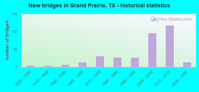
- New bridges - historical statistics
- 51930-1939
- 41940-1949
- 71950-1959
- 141960-1969
- 311970-1979
- 281980-1989
- 271990-1999
- 972000-2009
- 1192010-2019
- 142020-2022
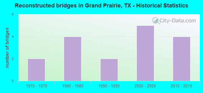
- Reconstructed bridges - Historical Statistics
- 21970-1979
- 41980-1989
- 21990-1999
- 52000-2009
- 42010-2019
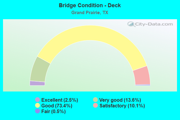
- Bridge Condition - Deck
- 2.5%Excellent
- 13.6%Very good
- 73.4%Good
- 10.1%Satisfactory
- 0.5%Fair
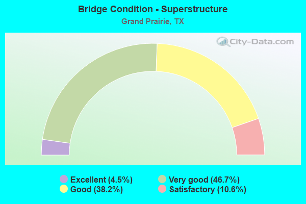
- Bridge Condition - Superstructure
- 4.5%Excellent
- 46.7%Very good
- 38.2%Good
- 10.6%Satisfactory
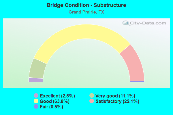
- Bridge Condition - Substructure
- 2.5%Excellent
- 11.1%Very good
- 63.8%Good
- 22.1%Satisfactory
- 0.5%Fair
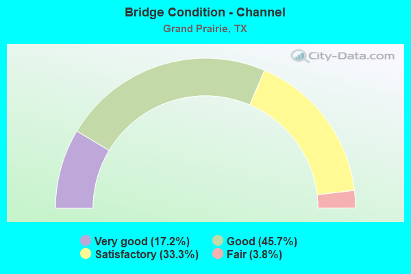
- Bridge Condition - Channel
- 17.2%Very good
- 45.7%Good
- 33.3%Satisfactory
- 3.8%Fair
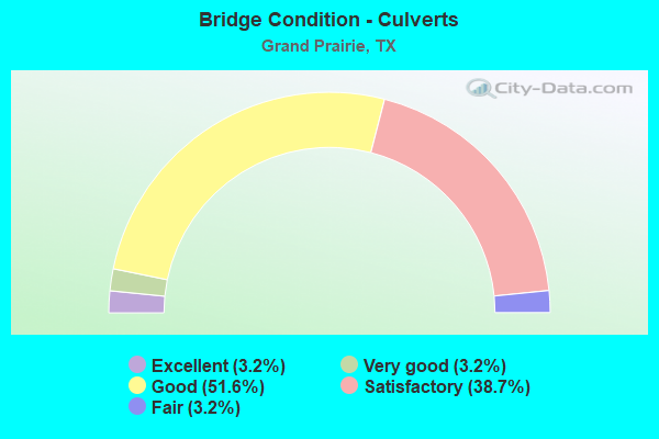
- Bridge Condition - Culverts
- 3.2%Excellent
- 3.2%Very good
- 51.6%Good
- 38.7%Satisfactory
- 3.2%Fair
Find on map >> Show street view
Structure Number: 180570F21233008, Location: 1.00 MI N OF IH 30 (Lat: 32.770733, Lng: -97.027539), Route carried "on" structure: City street , Year Built: 2009, Status: Open, Structure Length: 2.53m (8.30ft), Average Daily Traffic: 17,047 (year 2015), Truck Traffic: 3%, Average Future Daily Traffic: 23,865 (year 2037), Features Intersected: TRIB OF JOHNSON CR, Facility Carried by Structure: N CARRIER PKWY
Minimum Vertical Clearance: 30+ m (98+ ft), Kilometerpoint: 3.380, Lanes on structure: 4, Owner: City or Municipal Highway Agency, Approaching Roadway Width: 14.6m (47.9ft), Skew: 23 degrees, Material/Design: Concrete, Design/Construction: Culvert, Number Of Spans In Main Unit: 8, Length of Maximum Span: 2.4m (7.9ft), Curb or Sidewalk Widths: Left: 0.0m, Right: 1.2m (3.9ft)
Condition: Channel: Very good, Culverts: Satisfactory, Operating Rating: 32.7 metric tons, Method Used To Determine Operating Rating: Field evaluation and documented engineering judgment, Inventory Rating: 24.5 metric tons, Method Used To Determine Inventory Rating: Field evaluation and documented engineering judgment, Structural Evaluation: Equal to present minimum criteria, Waterway Adequacy: Superior to present desirable criteria, Approach Roadway Alignment: Equal to present desirable criteria, Designated Inspection Frequency: Every 24 months, Inspection Date: January 2021
Find on map >> Show street view
Structure Number: 180570F21233009, Location: 1.20 MI N OF IH 30 (Lat: 32.774672, Lng: -97.028414), Route carried "on" structure: City street , Year Built: 1975, Status: Open, Structure Length: 9.75m (31.99ft), Average Daily Traffic: 8,524 (year 2015), Truck Traffic: 3%, Average Future Daily Traffic: 11,933 (year 2037), Features Intersected: JOHNSON CREEK, Facility Carried by Structure: N CARRIER PKWY SB
Minimum Vertical Clearance: 30+ m (98+ ft), Kilometerpoint: 3.058, Lanes on structure: 2, Owner: City or Municipal Highway Agency, Approaching Roadway Width: 7.3m (24.0ft), Skew: 4 degrees, Material/Design: Prestressed concrete, Design/Construction: Stringer/Multi-beam, Number Of Spans In Main Unit: 4, Length of Maximum Span: 24.4m (80.1ft), Curb or Sidewalk Widths: Left: 0.0m, Right: 2.0m (6.6ft), Curb-To-Curb Width: 8.2m (26.9ft), Out-to-Out Width: 11.0m (36.1ft)
Condition: Deck: Good, Superstructure: Good, Substructure: Satisfactory, Channel: Good, Operating Rating: 32.7 metric tons, Method Used To Determine Operating Rating: Field evaluation and documented engineering judgment, Inventory Rating: 24.5 metric tons, Method Used To Determine Inventory Rating: Field evaluation and documented engineering judgment, Structural Evaluation: Equal to present minimum criteria, Deck Geometry: High priority of corrective action, Waterway Adequacy: Superior to present desirable criteria, Approach Roadway Alignment: Equal to present desirable criteria, Length Of Structure Improvement: 9.75m (31.99ft), Designated Inspection Frequency: Every 24 months, Inspection Date: January 2021, Bridge Improvement Cost: $17,000, Roadway Improvement Cost: $4,000, Total Project Cost: $21,000, Deck Structure Type: Concrete Cast-file-Place
Find on map >> Show street view
Structure Number: 180570F21236001, Location: 1.6 MI S of IH 20 (Lat: 32.654672, Lng: -97.007536), Route carried "on" structure: City street , Year Built: 2005, Status: Open, Structure Length: 1.89m (6.20ft), Average Daily Traffic: 6,306 (year 2019), Truck Traffic: 3%, Average Future Daily Traffic: 8,828 (year 2039), Design Load: HS 20, Features Intersected: TRIB MOUNTAIN CREEK, Facility Carried by Structure: S CARRIER PKWY
Minimum Vertical Clearance: 30+ m (98+ ft), Kilometerpoint: 2.575, Lanes on structure: 4, Owner: City or Municipal Highway Agency, Approaching Roadway Width: 14.6m (47.9ft), Skew: 23 degrees, Material/Design: Concrete, Design/Construction: Culvert, Number Of Spans In Main Unit: 5, Length of Maximum Span: 3.0m (9.8ft), Curb or Sidewalk Widths: Left: 1.2m (3.9ft), Right: 1.2m (3.9ft), Curb-To-Curb Width: 14.6m (47.9ft), Out-to-Out Width: 32.2m (105.6ft)
Condition: Channel: Very good, Culverts: Good, Operating Rating: 54.4 metric tons, Method Used To Determine Operating Rating: Assigned rating based on Load Factor Design (LFD) reported in metric tons, Inventory Rating: 32.7 metric tons, Method Used To Determine Inventory Rating: Assigned rating based on Load Factor Design (LFD) reported in metric tons, Structural Evaluation: Better than present minimum criteria, Deck Geometry: High priority of replacement, Waterway Adequacy: Superior to present desirable criteria, Approach Roadway Alignment: Equal to present desirable criteria, Designated Inspection Frequency: Every 24 months, Inspection Date: Febuary 2021, Deck Structure Type: Concrete Cast-file-Place, Wearing Surface/Protective System: Wearing Surface: Monolithic Concrete
Find on map >> Show street view
Structure Number: 180570F21436002, Location: 0.3 MI N OF MARSHALL DR (Lat: 32.723917, Lng: -97.015361), Route carried "on" structure: City street , Year Built: 1950, Status: Open, Structure Length: 1.16m (3.81ft), Average Daily Traffic: 10,600 (year 2011), Average Future Daily Traffic: 13,000 (year 2031), Features Intersected: COTTONWOOD CREEK, Facility Carried by Structure: S CARRIER PKWY
Minimum Vertical Clearance: 30+ m (98+ ft), Kilometerpoint: 9.093, Lanes on structure: 5, Owner: City or Municipal Highway Agency, Approaching Roadway Width: 13.4m (44.0ft), Material/Design: Concrete, Design/Construction: Culvert, Number Of Spans In Main Unit: 4, Length of Maximum Span: 2.7m (8.9ft)
Condition: Channel: Fair, Culverts: Satisfactory, Operating Rating: 32.7 metric tons, Method Used To Determine Operating Rating: Field evaluation and documented engineering judgment, Inventory Rating: 24.5 metric tons, Method Used To Determine Inventory Rating: Field evaluation and documented engineering judgment, Structural Evaluation: Equal to present minimum criteria, Waterway Adequacy: Equal to present minimum criteria, Approach Roadway Alignment: Equal to present desirable criteria, Length Of Structure Improvement: 1.16m (3.81ft), Designated Inspection Frequency: Every 24 months, Inspection Date: April 2021, Bridge Improvement Cost: $33,000, Roadway Improvement Cost: $8,000, Total Project Cost: $41,000
Find on map >> Show street view
Structure Number: 180570F21436003, Location: 0.1 MI S OF DICKERY RD (Lat: 32.726950, Lng: -97.015025), Route carried "on" structure: City street , Year Built: 1950, Status: Open, Structure Length: 1.62m (5.31ft), Average Daily Traffic: 10,600 (year 2011), Average Future Daily Traffic: 13,000 (year 2031), Features Intersected: COTTONWOOD CREEK, Facility Carried by Structure: S CARRIER PKWY
Minimum Vertical Clearance: 30+ m (98+ ft), Kilometerpoint: 9.415, Lanes on structure: 4, Owner: City or Municipal Highway Agency, Approaching Roadway Width: 13.4m (44.0ft), Skew: 20 degrees, Material/Design: Concrete, Design/Construction: Culvert, Number Of Spans In Main Unit: 5, Length of Maximum Span: 3.0m (9.8ft)
Condition: Channel: Good, Culverts: Satisfactory, Operating Rating: 32.7 metric tons, Method Used To Determine Operating Rating: Field evaluation and documented engineering judgment, Inventory Rating: 24.5 metric tons, Method Used To Determine Inventory Rating: Field evaluation and documented engineering judgment, Structural Evaluation: Equal to present minimum criteria, Waterway Adequacy: Equal to present minimum criteria, Approach Roadway Alignment: Equal to present desirable criteria, Length Of Structure Improvement: 1.62m (5.31ft), Designated Inspection Frequency: Every 24 months, Inspection Date: April 2021, Bridge Improvement Cost: $47,000, Roadway Improvement Cost: $12,000, Total Project Cost: $59,000
Find on map >> Show street view
Structure Number: 180570F21436005, Location: 0.05 MI N OF IH 20 (Lat: 32.676514, Lng: -97.006992), Route carried "on" structure: City street , Year Built: 1961, Year Reconstructed: 2001, Status: Open, Structure Length: 3.66m (12.01ft), Average Daily Traffic: 10,600 (year 2011), Average Future Daily Traffic: 13,000 (year 2031), Features Intersected: FISH CREEK, Facility Carried by Structure: S CARRIER PKWY
Minimum Vertical Clearance: 30+ m (98+ ft), Kilometerpoint: 3.541, Lanes on structure: 5, Owner: City or Municipal Highway Agency, Approaching Roadway Width: 17.4m (57.1ft), Skew: 20 degrees, Material/Design: Concrete, Design/Construction: Stringer/Multi-beam, Number Of Spans In Main Unit: 3, Length of Maximum Span: 12.2m (40.0ft), Curb or Sidewalk Widths: Left: 0.0m, Right: 3.0m (9.8ft), Curb-To-Curb Width: 17.4m (57.1ft), Out-to-Out Width: 27.1m (88.9ft)
Condition: Deck: Fair, Superstructure: Satisfactory, Substructure: Satisfactory, Channel: Satisfactory, Operating Rating: 32.7 metric tons, Method Used To Determine Operating Rating: Field evaluation and documented engineering judgment, Inventory Rating: 24.5 metric tons, Method Used To Determine Inventory Rating: Field evaluation and documented engineering judgment, Structural Evaluation: Equal to present minimum criteria, Deck Geometry: High priority of replacement, Waterway Adequacy: Equal to present minimum criteria, Approach Roadway Alignment: Equal to present desirable criteria, Length Of Structure Improvement: 3.66m (12.01ft), Designated Inspection Frequency: Every 24 months, Inspection Date: Febuary 2021, Bridge Improvement Cost: $14,000, Roadway Improvement Cost: $4,000, Total Project Cost: $18,000, Deck Structure Type: Concrete Cast-file-Place
Find on map >> Show street view
Structure Number: 180570F21436011, Location: 0.9 MI S OF SP 303 (Lat: 32.693758, Lng: -97.015589), Route carried "on" structure: City street , Year Built: 1985, Year Reconstructed: 2002, Status: Open, Structure Length: 1.31m (4.30ft), Average Daily Traffic: 10,600 (year 2011), Average Future Daily Traffic: 13,000 (year 2031), Features Intersected: KIRBY CREEK, Facility Carried by Structure: S CARRIER PKWY
Minimum Vertical Clearance: 30+ m (98+ ft), Kilometerpoint: 5.761, Lanes on structure: 4, Owner: City or Municipal Highway Agency, Approaching Roadway Width: 14.6m (47.9ft), Skew: 20 degrees, Material/Design: Concrete, Design/Construction: Culvert, Number Of Spans In Main Unit: 4, Length of Maximum Span: 3.0m (9.8ft)
Condition: Channel: Satisfactory, Culverts: Satisfactory, Operating Rating: 32.7 metric tons, Method Used To Determine Operating Rating: Field evaluation and documented engineering judgment, Inventory Rating: 24.5 metric tons, Method Used To Determine Inventory Rating: Field evaluation and documented engineering judgment, Structural Evaluation: Equal to present minimum criteria, Waterway Adequacy: Better than present minimum criteria, Approach Roadway Alignment: Equal to present desirable criteria, Designated Inspection Frequency: Every 24 months, Inspection Date: March 2021
Find on map >> Show street view
Structure Number: 180570F21436012, Location: 1.2 MI S OF SP 303 (Lat: 32.693742, Lng: -97.015597), Route carried "on" structure: City street , Year Built: 1985, Status: Open, Structure Length: 0.64m (2.10ft), Average Daily Traffic: 10,600 (year 2011), Average Future Daily Traffic: 13,000 (year 2031), Features Intersected: KIRBY CREEK TRIB, Facility Carried by Structure: S CARRIER PKWY
Minimum Vertical Clearance: 30+ m (98+ ft), Kilometerpoint: 5.633, Lanes on structure: 5, Owner: City or Municipal Highway Agency, Approaching Roadway Width: 18.3m (60.0ft), Skew: 20 degrees, Material/Design: Concrete, Design/Construction: Culvert, Number Of Spans In Main Unit: 2, Length of Maximum Span: 3.0m (9.8ft)
Condition: Channel: Good, Culverts: Good, Operating Rating: 32.7 metric tons, Method Used To Determine Operating Rating: Field evaluation and documented engineering judgment, Inventory Rating: 24.5 metric tons, Method Used To Determine Inventory Rating: Field evaluation and documented engineering judgment, Structural Evaluation: Equal to present minimum criteria, Waterway Adequacy: Better than present minimum criteria, Approach Roadway Alignment: Equal to present desirable criteria, Designated Inspection Frequency: Every 24 months, Inspection Date: April 2021
Find on map >> Show street view
Structure Number: 180570F28338001, Location: 1.6 MI S OF SP 303 (Lat: 32.690933, Lng: -97.003033), Route carried "on" structure: City street , Year Built: 1968, Status: Open, Structure Length: 2.77m (9.09ft), Average Daily Traffic: 8,100 (year 2011), Average Future Daily Traffic: 10,000 (year 2031), Design Load: H 15, Features Intersected: KIRBY CREEK, Facility Carried by Structure: CORN VALLEY RD
Minimum Vertical Clearance: 30+ m (98+ ft), Kilometerpoint: 2.575, Lanes on structure: 4, Owner: City or Municipal Highway Agency, Approaching Roadway Width: 14.6m (47.9ft), Material/Design: Concrete, Design/Construction: Stringer/Multi-beam, Number Of Spans In Main Unit: 3, Length of Maximum Span: 9.1m (29.9ft), Curb or Sidewalk Widths: Left: 0.0m, Right: 1.2m (3.9ft), Curb-To-Curb Width: 14.6m (47.9ft), Out-to-Out Width: 16.8m (55.1ft)
Condition: Deck: Satisfactory, Superstructure: Satisfactory, Substructure: Satisfactory, Channel: Satisfactory, Operating Rating: 39.9 metric tons, Method Used To Determine Operating Rating: Load Factor (LF), Inventory Rating: 23.6 metric tons, Method Used To Determine Inventory Rating: Load Factor (LF), Structural Evaluation: Somewhat better than minimum adequacy, Deck Geometry: High priority of replacement, Waterway Adequacy: Better than present minimum criteria, Approach Roadway Alignment: Equal to present desirable criteria, Length Of Structure Improvement: 2.77m (9.09ft), Designated Inspection Frequency: Every 24 months, Inspection Date: April 2021, Bridge Improvement Cost: $9,000, Roadway Improvement Cost: $2,000, Total Project Cost: $11,000, Deck Structure Type: Concrete Cast-file-Place
Find on map >> Show street view
Structure Number: 180570F39498001, Location: 0.06 MI W OF SH 161 SBFR (Lat: 32.765408, Lng: -97.031044), Route carried "on" structure: City street , Year Built: 2007, Status: Open, Structure Length: 1.74m (5.71ft), Average Daily Traffic: 5,996 (year 2019), Truck Traffic: 3%, Average Future Daily Traffic: 6,735 (year 2037), Design Load: HS 20, Features Intersected: TRIB OF JOHNSON CR, Facility Carried by Structure: EGYPTIAN WAY
Minimum Vertical Clearance: 30+ m (98+ ft), Kilometerpoint: 0.579, Lanes on structure: 2, Owner: City or Municipal Highway Agency, Approaching Roadway Width: 13.4m (44.0ft), Material/Design: Concrete, Design/Construction: Culvert, Number Of Spans In Main Unit: 5, Length of Maximum Span: 3.0m (9.8ft), Curb or Sidewalk Widths: Left: 1.4m (4.6ft), Right: 1.4m (4.6ft)
Condition: Channel: Good, Culverts: Satisfactory, Operating Rating: 44.4 metric tons, Method Used To Determine Operating Rating: No rating analysis performed, Inventory Rating: 32.7 metric tons, Method Used To Determine Inventory Rating: No rating analysis performed, Structural Evaluation: Equal to present minimum criteria, Waterway Adequacy: Superior to present desirable criteria, Approach Roadway Alignment: Equal to present desirable criteria, Designated Inspection Frequency: Every 24 months, Inspection Date: Febuary 2021
Find on map >> Show street view
Structure Number: 180570F48800001, Location: STORY RD INTERSECTION (Lat: 32.783114, Lng: -96.975928), Route carried "on" structure: County highway , Year Built: 2012, Status: Open, Structure Length: 31.67m (103.90ft), Average Daily Traffic: 3,610 (year 2015), Truck Traffic: 3%, Average Future Daily Traffic: 5,050 (year 2037), Design Load: HL 93, Features Intersected: BEAR CREEK, Facility Carried by Structure: HUNTER FERRELL WB
Minimum Vertical Clearance: 30+ m (98+ ft), Kilometerpoint: 7.387, Lanes on structure: 2, Owner: City or Municipal Highway Agency, Approaching Roadway Width: 7.3m (24.0ft), Skew: 9 degrees, Material/Design: Prestressed concrete, Design/Construction: Stringer/Multi-beam, Number Of Spans In Main Unit: 10, Length of Maximum Span: 36.6m (120.1ft), Curb or Sidewalk Widths: Left: 0.0m, Right: 4.3m (14.1ft), Curb-To-Curb Width: 8.7m (28.5ft), Out-to-Out Width: 11.3m (37.1ft)
Condition: Deck: Good, Superstructure: Very good, Substructure: Good, Channel: Satisfactory, Operating Rating: 54.4 metric tons, Method Used To Determine Operating Rating: Assigned ratings based on Load and Resistance Factor Design (LRFD) reported in metric tons, Inventory Rating: 32.7 metric tons, Method Used To Determine Inventory Rating: Assigned ratings based on Load and Resistance Factor Design (LRFD) reported in metric tons, Structural Evaluation: Better than present minimum criteria, Deck Geometry: High priority of corrective action, Waterway Adequacy: Superior to present desirable criteria, Approach Roadway Alignment: Equal to present desirable criteria, Designated Inspection Frequency: Every 24 months, Inspection Date: Febuary 2021, Deck Structure Type: Concrete Precast Panels
Find on map >> Show street view
Structure Number: 180570F48800002, Location: AT STORY RD INTERSECTION (Lat: 32.782106, Lng: -96.976333), Route carried "on" structure: County highway 30464, Year Built: 2012, Status: Open, Structure Length: 29.29m (96.10ft), Average Daily Traffic: 4,678 (year 2015), Truck Traffic: 3%, Average Future Daily Traffic: 6,549 (year 2037), Design Load: HL 93, Features Intersected: BEAR CREEK, Facility Carried by Structure: HUNTER FERRELL EB
Minimum Vertical Clearance: 30+ m (98+ ft), Kilometerpoint: 7.387, Lanes on structure: 2, Owner: City or Municipal Highway Agency, Approaching Roadway Width: 12.2m (40.0ft), Skew: 9 degrees, Material/Design: Prestressed concrete, Design/Construction: Stringer/Multi-beam, Number Of Spans In Main Unit: 9, Length of Maximum Span: 36.6m (120.1ft), Curb or Sidewalk Widths: Left: 0.0m, Right: 4.3m (14.1ft), Curb-To-Curb Width: 12.1m (39.7ft), Out-to-Out Width: 16.7m (54.8ft)
Condition: Deck: Good, Superstructure: Good, Substructure: Good, Channel: Satisfactory, Operating Rating: 54.4 metric tons, Method Used To Determine Operating Rating: Assigned ratings based on Load and Resistance Factor Design (LRFD) reported in metric tons, Inventory Rating: 32.7 metric tons, Method Used To Determine Inventory Rating: Assigned ratings based on Load and Resistance Factor Design (LRFD) reported in metric tons, Structural Evaluation: Better than present minimum criteria, Deck Geometry: Better than present minimum criteria, Waterway Adequacy: Superior to present desirable criteria, Approach Roadway Alignment: Equal to present desirable criteria, Designated Inspection Frequency: Every 24 months, Inspection Date: Febuary 2021, Deck Structure Type: Concrete Precast Panels
Find on map >> Show street view
Structure Number: 180570F51526001, Location: 1.55 MI W OF LP 12 (Lat: 32.746633, Lng: -96.946092), Route carried "on" structure: City street 223, Year Built: 1930, Status: Open, Structure Length: 5.12m (16.80ft), Average Daily Traffic: 7,050 (year 2020), Average Future Daily Traffic: 9,000 (year 2031), Features Intersected: MOUNTAIN CREEK TRIB, Facility Carried by Structure: JEFFERSON BLVD WB
Minimum Vertical Clearance: 30+ m (98+ ft), Kilometerpoint: 10.300, Lanes on structure: 2, Owner: City or Municipal Highway Agency, Approaching Roadway Width: 7.9m (25.9ft), Material/Design: Concrete, Design/Construction: Slab, Number Of Spans In Main Unit: 7, Length of Maximum Span: 7.3m (24.0ft), Curb or Sidewalk Widths: Left: 0.5m (1.6ft), Right: 0.5m (1.6ft), Curb-To-Curb Width: 7.8m (25.6ft), Out-to-Out Width: 9.7m (31.8ft)
Condition: Deck: Good, Superstructure: Good, Substructure: Good, Channel: Good, Operating Rating: 32.7 metric tons, Method Used To Determine Operating Rating: Field evaluation and documented engineering judgment, Inventory Rating: 24.5 metric tons, Method Used To Determine Inventory Rating: Field evaluation and documented engineering judgment, Structural Evaluation: Equal to present minimum criteria, Deck Geometry: High priority of replacement, Waterway Adequacy: Superior to present desirable criteria, Approach Roadway Alignment: Equal to present desirable criteria, Length Of Structure Improvement: 5.12m (16.80ft), Designated Inspection Frequency: Every 24 months, Inspection Date: April 2021, Bridge Improvement Cost: $9,000, Roadway Improvement Cost: $2,000, Total Project Cost: $11,000, Deck Structure Type: Concrete Cast-file-Place, Wearing Surface/Protective System: Wearing Surface: Bituminous
Find on map >> Show street view
Structure Number: 180570F51526002, Location: 1.20 MI W OF LP 12 (Lat: 32.746769, Lng: -96.940297), Route carried "on" structure: City street 223, Year Built: 1930, Status: Open, Structure Length: 7.32m (24.02ft), Average Daily Traffic: 7,050 (year 2020), Average Future Daily Traffic: 9,000 (year 2031), Features Intersected: MOUNTAIN CREEK TRIB, Facility Carried by Structure: JEFFERSON BLVD WB
Minimum Vertical Clearance: 30+ m (98+ ft), Kilometerpoint: 10.783, Lanes on structure: 2, Owner: City or Municipal Highway Agency, Approaching Roadway Width: 7.9m (25.9ft), Material/Design: Concrete, Design/Construction: Slab, Number Of Spans In Main Unit: 10, Length of Maximum Span: 7.3m (24.0ft), Curb or Sidewalk Widths: Left: 0.5m (1.6ft), Right: 0.5m (1.6ft), Curb-To-Curb Width: 8.5m (27.9ft), Out-to-Out Width: 9.7m (31.8ft)
Condition: Deck: Good, Superstructure: Good, Substructure: Satisfactory, Channel: Good, Operating Rating: 32.7 metric tons, Method Used To Determine Operating Rating: Field evaluation and documented engineering judgment, Inventory Rating: 24.5 metric tons, Method Used To Determine Inventory Rating: Field evaluation and documented engineering judgment, Structural Evaluation: Equal to present minimum criteria, Deck Geometry: High priority of corrective action, Waterway Adequacy: Superior to present desirable criteria, Approach Roadway Alignment: Equal to present desirable criteria, Length Of Structure Improvement: 7.32m (24.02ft), Designated Inspection Frequency: Every 24 months, Inspection Date: April 2021, Bridge Improvement Cost: $13,000, Roadway Improvement Cost: $3,000, Total Project Cost: $16,000, Deck Structure Type: Concrete Cast-file-Place, Wearing Surface/Protective System: Wearing Surface: Bituminous
Find on map >> Show street view
Structure Number: 180570F51526003, Location: 0.70 MI W OF LP 12 (Lat: 32.747294, Lng: -96.932206), Route carried "on" structure: City street 223, Year Built: 1930, Status: Open, Structure Length: 7.32m (24.02ft), Average Daily Traffic: 7,000 (year 2011), Average Future Daily Traffic: 9,000 (year 2031), Features Intersected: MOUNTAIN CREEK TRIB, Facility Carried by Structure: JEFFERSON BLVD WB
Minimum Vertical Clearance: 30+ m (98+ ft), Kilometerpoint: 11.587, Lanes on structure: 2, Owner: City or Municipal Highway Agency, Approaching Roadway Width: 7.9m (25.9ft), Material/Design: Concrete, Design/Construction: Slab, Number Of Spans In Main Unit: 10, Length of Maximum Span: 7.3m (24.0ft), Curb or Sidewalk Widths: Left: 0.5m (1.6ft), Right: 0.5m (1.6ft), Curb-To-Curb Width: 8.5m (27.9ft), Out-to-Out Width: 9.7m (31.8ft)
Condition: Deck: Good, Superstructure: Good, Substructure: Good, Channel: Good, Operating Rating: 32.7 metric tons, Method Used To Determine Operating Rating: Field evaluation and documented engineering judgment, Inventory Rating: 24.5 metric tons, Method Used To Determine Inventory Rating: Field evaluation and documented engineering judgment, Structural Evaluation: Equal to present minimum criteria, Deck Geometry: High priority of corrective action, Waterway Adequacy: Superior to present desirable criteria, Approach Roadway Alignment: Equal to present desirable criteria, Length Of Structure Improvement: 7.32m (24.02ft), Designated Inspection Frequency: Every 24 months, Inspection Date: April 2021, Bridge Improvement Cost: $13,000, Roadway Improvement Cost: $3,000, Total Project Cost: $16,000, Deck Structure Type: Concrete Cast-file-Place, Wearing Surface/Protective System: Wearing Surface: Bituminous
Find on map >> Show street view
Structure Number: 180570F54705002, Location: 5.8 MI W OF US 67 (Lat: 32.585378, Lng: -97.026017), Route carried "on" structure: City street , Year Built: 1984, Status: Open, Structure Length: 58.52m (191.99ft), Average Daily Traffic: 1,200 (year 2011), Truck Traffic: 1%, Average Future Daily Traffic: 5,000 (year 2031), Features Intersected: JOE POOL LAKE, Facility Carried by Structure: LAKE RIDGE PKWY NB
Minimum Vertical Clearance: 30+ m (98+ ft), Kilometerpoint: 10.139, Lanes on structure: 2, Owner: City or Municipal Highway Agency, Approaching Roadway Width: 7.9m (25.9ft), Material/Design: Prestressed concrete, Design/Construction: Stringer/Multi-beam, Number Of Spans In Main Unit: 24, Length of Maximum Span: 24.4m (80.1ft), Curb-To-Curb Width: 8.1m (26.6ft), Out-to-Out Width: 8.6m (28.2ft)
Condition: Deck: Satisfactory, Superstructure: Good, Substructure: Good, Channel: Good, Operating Rating: 32.7 metric tons, Method Used To Determine Operating Rating: Field evaluation and documented engineering judgment, Inventory Rating: 24.5 metric tons, Method Used To Determine Inventory Rating: Field evaluation and documented engineering judgment, Structural Evaluation: Equal to present minimum criteria, Deck Geometry: High priority of replacement, Waterway Adequacy: Superior to present desirable criteria, Approach Roadway Alignment: Equal to present desirable criteria, Designated Inspection Frequency: Every 24 months, Underwater Inspection Frequency: Every 60 months, Inspection Date: Febuary 2021, Underwater Inspection Date: May 2021, Deck Structure Type: Concrete Cast-file-Place
Find on map >> Show street view
Structure Number: 180570F54705003, Location: 5.8 MI W OF US 67 (Lat: 32.585300, Lng: -97.026089), Route carried "on" structure: City street , Year Built: 1984, Status: Open, Structure Length: 58.52m (191.99ft), Average Daily Traffic: 1,100 (year 2011), Truck Traffic: 1%, Average Future Daily Traffic: 5,000 (year 2031), Features Intersected: JOE POOL LAKE, Facility Carried by Structure: LAKE RIDGE PKWY SB
Minimum Vertical Clearance: 30+ m (98+ ft), Kilometerpoint: 10.139, Lanes on structure: 2, Owner: City or Municipal Highway Agency, Approaching Roadway Width: 7.9m (25.9ft), Material/Design: Prestressed concrete, Design/Construction: Stringer/Multi-beam, Number Of Spans In Main Unit: 24, Length of Maximum Span: 24.4m (80.1ft), Curb-To-Curb Width: 8.1m (26.6ft), Out-to-Out Width: 8.6m (28.2ft)
Condition: Deck: Good, Superstructure: Good, Substructure: Good, Channel: Good, Operating Rating: 32.7 metric tons, Method Used To Determine Operating Rating: Field evaluation and documented engineering judgment, Inventory Rating: 24.5 metric tons, Method Used To Determine Inventory Rating: Field evaluation and documented engineering judgment, Structural Evaluation: Equal to present minimum criteria, Deck Geometry: High priority of replacement, Waterway Adequacy: Superior to present desirable criteria, Approach Roadway Alignment: Equal to present desirable criteria, Designated Inspection Frequency: Every 24 months, Underwater Inspection Frequency: Every 60 months, Inspection Date: Febuary 2021, Underwater Inspection Date: May 2021, Deck Structure Type: Concrete Cast-file-Place
Find on map >> Show street view
Structure Number: 180570F54705004, Location: 1.0 MI S OF IH 20 (Lat: 32.665839, Lng: -97.025869), Route carried "on" structure: City street , Year Built: 2013, Status: Open, Structure Length: 7.47m (24.51ft), Average Daily Traffic: 24,500 (year 2009), Truck Traffic: 10%, Average Future Daily Traffic: 29,700 (year 2029), Design Load: HL 93, Features Intersected: FISH CREEK, Facility Carried by Structure: LAKE RIDGE PKWY NB
Minimum Vertical Clearance: 30+ m (98+ ft), Kilometerpoint: 0.000, Lanes on structure: 3, Owner: City or Municipal Highway Agency, Approaching Roadway Width: 11.6m (38.1ft), Material/Design: Prestressed concrete, Design/Construction: Stringer/Multi-beam, Number Of Spans In Main Unit: 1, Number Of Approach Spans: 2, Length of Maximum Span: 35.1m (115.2ft), Curb or Sidewalk Widths: Left: 0.0m, Right: 3.0m (9.8ft), Curb-To-Curb Width: 11.6m (38.1ft), Out-to-Out Width: 15.2m (49.9ft)
Condition: Deck: Very good, Superstructure: Very good, Substructure: Good, Channel: Very good, Operating Rating: 54.4 metric tons, Method Used To Determine Operating Rating: Assigned ratings based on Load and Resistance Factor Design (LRFD) reported in metric tons, Inventory Rating: 32.7 metric tons, Method Used To Determine Inventory Rating: Assigned ratings based on Load and Resistance Factor Design (LRFD) reported in metric tons, Structural Evaluation: Better than present minimum criteria, Deck Geometry: High priority of replacement, Waterway Adequacy: Better than present minimum criteria, Approach Roadway Alignment: Equal to present desirable criteria, Designated Inspection Frequency: Every 24 months, Inspection Date: June 2021, Deck Structure Type: Concrete Cast-file-Place
Find on map >> Show street view
Structure Number: 180570F54705005, Location: 1.0 MI S OF IH 20 (Lat: 32.665989, Lng: -97.026064), Route carried "on" structure: City street , Year Built: 2013, Status: Open, Structure Length: 7.47m (24.51ft), Average Daily Traffic: 24,500 (year 2009), Truck Traffic: 10%, Average Future Daily Traffic: 29,700 (year 2029), Design Load: HL 93, Features Intersected: FISH CREEK, Facility Carried by Structure: LAKE RIDGE PKWY SB
Minimum Vertical Clearance: 30+ m (98+ ft), Kilometerpoint: 0.000, Lanes on structure: 3, Owner: City or Municipal Highway Agency, Approaching Roadway Width: 11.6m (38.1ft), Material/Design: Prestressed concrete, Design/Construction: Stringer/Multi-beam, Number Of Spans In Main Unit: 1, Number Of Approach Spans: 2, Length of Maximum Span: 35.1m (115.2ft), Curb or Sidewalk Widths: Left: 1.8m (5.9ft), Right: 0.0m, Curb-To-Curb Width: 11.6m (38.1ft), Out-to-Out Width: 14.0m (45.9ft)
Condition: Deck: Very good, Superstructure: Very good, Substructure: Good, Channel: Very good, Operating Rating: 54.4 metric tons, Method Used To Determine Operating Rating: Assigned ratings based on Load and Resistance Factor Design (LRFD) reported in metric tons, Inventory Rating: 32.7 metric tons, Method Used To Determine Inventory Rating: Assigned ratings based on Load and Resistance Factor Design (LRFD) reported in metric tons, Structural Evaluation: Better than present minimum criteria, Deck Geometry: High priority of replacement, Waterway Adequacy: Better than present minimum criteria, Approach Roadway Alignment: Equal to present desirable criteria, Designated Inspection Frequency: Every 24 months, Inspection Date: June 2021, Deck Structure Type: Concrete Cast-file-Place
Find on map >> Show street view
Structure Number: 180570F56203001, Location: 0.20 MI E OF L. STAR PKWY (Lat: 32.767394, Lng: -96.992558), Route carried "on" structure: State highway , Year Built: 2004, Status: Open, Structure Length: 12.80m (41.99ft), Average Daily Traffic: 50 (year 2011), Truck Traffic: 1%, Average Future Daily Traffic: 200 (year 2031), Design Load: HS 20, Features Intersected: SUMP LAKE, Facility Carried by Structure: POLLOCK PLACE RD
Minimum Vertical Clearance: 30+ m (98+ ft), Kilometerpoint: 0.161, Lanes on structure: 2, Owner: City or Municipal Highway Agency, Approaching Roadway Width: 7.9m (25.9ft), Material/Design: Prestressed concrete, Design/Construction: Stringer/Multi-beam, Number Of Spans In Main Unit: 5, Length of Maximum Span: 26.8m (87.9ft), Curb-To-Curb Width: 8.0m (26.2ft), Out-to-Out Width: 9.8m (32.2ft)
Condition: Deck: Good, Superstructure: Very good, Substructure: Satisfactory, Channel: Good, Operating Rating: 54.4 metric tons, Method Used To Determine Operating Rating: Assigned rating based on Load Factor Design (LFD) reported in metric tons, Inventory Rating: 32.7 metric tons, Method Used To Determine Inventory Rating: Assigned rating based on Load Factor Design (LFD) reported in metric tons, Structural Evaluation: Equal to present minimum criteria, Deck Geometry: High priority of replacement, Waterway Adequacy: Superior to present desirable criteria, Approach Roadway Alignment: Equal to present desirable criteria, Designated Inspection Frequency: Every 24 months, Inspection Date: Febuary 2021, Deck Structure Type: Concrete Cast-file-Place
Find on map >> Show street view
Structure Number: 180570F58685002, Location: 0.1 MI E OF FM 1382 (Lat: 32.720456, Lng: -96.992033), Route carried "on" structure: City street , Year Built: 1950, Year Reconstructed: 1993, Status: Open, Structure Length: 1.22m (4.00ft), Average Daily Traffic: 7,000 (year 2011), Average Future Daily Traffic: 8,000 (year 2031), Features Intersected: COTTONWOOD CREEK TRIB, Facility Carried by Structure: MARSHALL DR
Minimum Vertical Clearance: 30+ m (98+ ft), Kilometerpoint: 2.174, Lanes on structure: 4, Owner: City or Municipal Highway Agency, Approaching Roadway Width: 13.4m (44.0ft), Skew: 3 degrees, Material/Design: Concrete, Design/Construction: Culvert, Number Of Spans In Main Unit: 3, Length of Maximum Span: 3.0m (9.8ft), Curb or Sidewalk Widths: Left: 0.0m, Right: 1.5m (4.9ft)
Condition: Channel: Satisfactory, Culverts: Satisfactory, Operating Rating: 32.7 metric tons, Method Used To Determine Operating Rating: Field evaluation and documented engineering judgment, Inventory Rating: 24.5 metric tons, Method Used To Determine Inventory Rating: Field evaluation and documented engineering judgment, Structural Evaluation: Equal to present minimum criteria, Waterway Adequacy: Equal to present minimum criteria, Approach Roadway Alignment: Equal to present desirable criteria, Length Of Structure Improvement: 1.22m (4.00ft), Designated Inspection Frequency: Every 24 months, Inspection Date: April 2021, Bridge Improvement Cost: $4,000, Roadway Improvement Cost: $1,000, Total Project Cost: $5,000
Find on map >> Show street view
Structure Number: 180570F58685005, Location: 0.3 MI W OF CARRIER PKWY (Lat: 32.720758, Lng: -97.018794), Route carried "on" structure: City street , Year Built: 2021, Status: Open, Structure Length: 3.66m (12.01ft), Average Daily Traffic: 7,518 (year 2019), Truck Traffic: 3%, Average Future Daily Traffic: 10,525 (year 2039), Design Load: HL 93, Features Intersected: COTTONWOOD CREEK, Facility Carried by Structure: MARSHALL DRIVE
Minimum Vertical Clearance: 30+ m (98+ ft), Kilometerpoint: 3.219, Lanes on structure: 4, Owner: City or Municipal Highway Agency, Approaching Roadway Width: 13.4m (44.0ft), Material/Design: Prestressed concrete, Number Of Spans In Main Unit: 3, Length of Maximum Span: 12.2m (40.0ft), Curb or Sidewalk Widths: Left: 0.0m, Right: 2.0m (6.6ft), Curb-To-Curb Width: 14.0m (45.9ft), Out-to-Out Width: 16.7m (54.8ft)
Condition: Deck: Very good, Superstructure: Excellent, Substructure: Excellent, Channel: Very good, Operating Rating: 54.4 metric tons, Method Used To Determine Operating Rating: Assigned ratings based on Load and Resistance Factor Design (LRFD) reported in metric tons, Inventory Rating: 32.7 metric tons, Method Used To Determine Inventory Rating: Assigned ratings based on Load and Resistance Factor Design (LRFD) reported in metric tons, Structural Evaluation: Superior to present desirable criteria, Deck Geometry: High priority of replacement, Waterway Adequacy: Superior to present desirable criteria, Approach Roadway Alignment: Equal to present desirable criteria, Designated Inspection Frequency: Every 24 months, Inspection Date: April 2021, Deck Structure Type: Concrete Cast-file-Place
Find on map >> Show street view
Structure Number: 180570F59161002, Location: 1.8 MI S OF IH 20 (Lat: 32.651997, Lng: -97.027889), Route carried "on" structure: City street , Year Built: 1978, Status: Open, Structure Length: 0.76m (2.49ft), Average Daily Traffic: 1,500 (year 2011), Average Future Daily Traffic: 2,100 (year 2031), Features Intersected: TRAILWOOD BRANCH, Facility Carried by Structure: MATTHEW RD
Minimum Vertical Clearance: 30+ m (98+ ft), Kilometerpoint: 2.897, Lanes on structure: 4, Owner: City or Municipal Highway Agency, Approaching Roadway Width: 14.6m (47.9ft), Skew: 20 degrees, Material/Design: Concrete, Design/Construction: Culvert, Number Of Spans In Main Unit: 3, Length of Maximum Span: 2.4m (7.9ft), Curb or Sidewalk Widths: Left: 1.2m (3.9ft), Right: 1.2m (3.9ft)
Condition: Channel: Good, Culverts: Fair, Operating Rating: 32.7 metric tons, Method Used To Determine Operating Rating: Field evaluation and documented engineering judgment, Inventory Rating: 24.5 metric tons, Method Used To Determine Inventory Rating: Field evaluation and documented engineering judgment, Structural Evaluation: Somewhat better than minimum adequacy, Waterway Adequacy: Better than present minimum criteria, Approach Roadway Alignment: Equal to present desirable criteria, Designated Inspection Frequency: Every 24 months, Inspection Date: April 2021
Find on map >> Show street view
Structure Number: 180570F60015001, Location: 0.10 MI E OF BELT LINE RD (Lat: 32.767339, Lng: -96.992558), Route carried "on" structure: City street , Year Built: 1990, Status: Open, Structure Length: 7.96m (26.12ft), Average Daily Traffic: 750 (year 2011), Average Future Daily Traffic: 785 (year 2031), Design Load: HS 20, Features Intersected: DRAINAGE CHANNEL, Facility Carried by Structure: LONE STAR PKWY WB
Minimum Vertical Clearance: 30+ m (98+ ft), Kilometerpoint: 0.161, Lanes on structure: 2, Owner: City or Municipal Highway Agency, Approaching Roadway Width: 7.3m (24.0ft), Material/Design: Concrete, Design/Construction: Stringer/Multi-beam, Number Of Spans In Main Unit: 7, Length of Maximum Span: 12.2m (40.0ft), Curb or Sidewalk Widths: Left: 0.5m (1.6ft), Right: 1.5m (4.9ft), Curb-To-Curb Width: 7.3m (24.0ft), Out-to-Out Width: 10.1m (33.1ft)
Condition: Deck: Satisfactory, Superstructure: Satisfactory, Substructure: Satisfactory, Channel: Good, Operating Rating: 68.9 metric tons, Method Used To Determine Operating Rating: Load Factor (LF), Inventory Rating: 40.8 metric tons, Method Used To Determine Inventory Rating: Load Factor (LF), Structural Evaluation: Equal to present minimum criteria, Deck Geometry: High priority of replacement, Waterway Adequacy: Better than present minimum criteria, Approach Roadway Alignment: Equal to present desirable criteria, Length Of Structure Improvement: 7.96m (26.12ft), Designated Inspection Frequency: Every 24 months, Inspection Date: Febuary 2021, Deck Structure Type: Concrete Cast-file-Place
Find on map >> Show street view
Structure Number: 180570F60015002, Location: 0.10 MI E OF BELT LINE RD (Lat: 32.767239, Lng: -96.992497), Route carried "on" structure: City street , Year Built: 1990, Status: Open, Structure Length: 7.96m (26.12ft), Average Daily Traffic: 750 (year 2011), Average Future Daily Traffic: 785 (year 2031), Design Load: HS 20, Features Intersected: DRAINAGE CHANNEL, Facility Carried by Structure: LONE STAR PKWY EB
Minimum Vertical Clearance: 30+ m (98+ ft), Kilometerpoint: 0.161, Lanes on structure: 2, Owner: City or Municipal Highway Agency, Approaching Roadway Width: 7.3m (24.0ft), Material/Design: Concrete, Design/Construction: Stringer/Multi-beam, Number Of Spans In Main Unit: 7, Length of Maximum Span: 12.2m (40.0ft), Curb or Sidewalk Widths: Left: 0.5m (1.6ft), Right: 1.5m (4.9ft), Curb-To-Curb Width: 7.3m (24.0ft), Out-to-Out Width: 10.1m (33.1ft)
Condition: Deck: Satisfactory, Superstructure: Satisfactory, Substructure: Satisfactory, Channel: Good, Operating Rating: 68.9 metric tons, Method Used To Determine Operating Rating: Load Factor (LF), Inventory Rating: 40.8 metric tons, Method Used To Determine Inventory Rating: Load Factor (LF), Structural Evaluation: Equal to present minimum criteria, Deck Geometry: High priority of replacement, Waterway Adequacy: Equal to present minimum criteria, Approach Roadway Alignment: Equal to present desirable criteria, Length Of Structure Improvement: 7.96m (26.12ft), Designated Inspection Frequency: Every 24 months, Inspection Date: Febuary 2021, Deck Structure Type: Concrete Cast-file-Place
Find on map >> Show street view
Structure Number: 180570F63000001, Location: 0.6 MI E OF PGBTP (Lat: 32.792456, Lng: -97.006883), Route carried "on" structure: City street , Year Built: 2018, Status: Open, Structure Length: 0.67m (2.20ft), Average Daily Traffic: 2,025 (year 2019), Truck Traffic: 3%, Average Future Daily Traffic: 2,840 (year 2039), Design Load: HL 93, Features Intersected: Drainage Ditch, Facility Carried by Structure: W. Oakdale Rd.
Minimum Vertical Clearance: 30+ m (98+ ft), Kilometerpoint: 0.000, Lanes on structure: 2, Owner: City or Municipal Highway Agency, Approaching Roadway Width: 7.9m (25.9ft), Material/Design: Concrete, Design/Construction: Culvert, Number Of Spans In Main Unit: 4, Length of Maximum Span: 1.2m (3.9ft), Curb-To-Curb Width: 9.1m (29.9ft), Out-to-Out Width: 10.4m (34.1ft)
Condition: Channel: Good, Culverts: Very good, Operating Rating: 54.4 metric tons, Method Used To Determine Operating Rating: Assigned ratings based on Load and Resistance Factor Design (LRFD) reported in metric tons, Inventory Rating: 32.7 metric tons, Method Used To Determine Inventory Rating: Assigned ratings based on Load and Resistance Factor Design (LRFD) reported in metric tons, Structural Evaluation: Equal to present desirable criteria, Deck Geometry: Meets minimum limits, Waterway Adequacy: Meets minimum limits, Approach Roadway Alignment: Equal to present desirable criteria, Designated Inspection Frequency: Every 24 months, Inspection Date: April 2021, Wearing Surface/Protective System: Wearing Surface: Bituminous
Find on map >> Show street view
Structure Number: 180570F63000002, Location: 1.2 MI E OF PGBTP (Lat: 32.792406, Lng: -96.997056), Route carried "on" structure: City street , Year Built: 2018, Status: Open, Structure Length: 0.67m (2.20ft), Average Daily Traffic: 2,025 (year 2019), Truck Traffic: 3%, Average Future Daily Traffic: 2,840 (year 2039), Design Load: HL 93, Features Intersected: Drainage Ditch #2, Facility Carried by Structure: W. Oakdale Rd.
Minimum Vertical Clearance: 30+ m (98+ ft), Kilometerpoint: 0.000, Lanes on structure: 2, Owner: City or Municipal Highway Agency, Approaching Roadway Width: 7.9m (25.9ft), Material/Design: Concrete, Design/Construction: Culvert, Number Of Spans In Main Unit: 4, Length of Maximum Span: 1.2m (3.9ft), Curb-To-Curb Width: 8.9m (29.2ft), Out-to-Out Width: 10.4m (34.1ft)
Condition: Channel: Good, Culverts: Good, Operating Rating: 54.4 metric tons, Method Used To Determine Operating Rating: Assigned ratings based on Load and Resistance Factor Design (LRFD) reported in metric tons, Inventory Rating: 32.7 metric tons, Method Used To Determine Inventory Rating: Assigned ratings based on Load and Resistance Factor Design (LRFD) reported in metric tons, Structural Evaluation: Better than present minimum criteria, Deck Geometry: Meets minimum limits, Waterway Adequacy: Meets minimum limits, Approach Roadway Alignment: Equal to present desirable criteria, Designated Inspection Frequency: Every 24 months, Inspection Date: April 2021, Wearing Surface/Protective System: Wearing Surface: Bituminous
Find on map >> Show street view
Structure Number: 180570F63000003, Location: 1.3 MI E OF PGBTP (Lat: 32.792408, Lng: -96.995694), Route carried "on" structure: City street , Year Built: 2018, Status: Open, Structure Length: 0.91m (2.99ft), Average Daily Traffic: 2,025 (year 2019), Truck Traffic: 3%, Average Future Daily Traffic: 2,840 (year 2039), Design Load: HL 93, Features Intersected: Drainage Ditch #3, Facility Carried by Structure: W. Oakdale Rd.
Minimum Vertical Clearance: 30+ m (98+ ft), Kilometerpoint: 0.000, Lanes on structure: 2, Owner: City or Municipal Highway Agency, Approaching Roadway Width: 7.9m (25.9ft), Material/Design: Concrete, Design/Construction: Culvert, Number Of Spans In Main Unit: 4, Length of Maximum Span: 1.8m (5.9ft), Curb-To-Curb Width: 8.9m (29.2ft), Out-to-Out Width: 10.4m (34.1ft)
Condition: Channel: Good, Culverts: Very good, Operating Rating: 54.4 metric tons, Method Used To Determine Operating Rating: Assigned ratings based on Load and Resistance Factor Design (LRFD) reported in metric tons, Inventory Rating: 32.7 metric tons, Method Used To Determine Inventory Rating: Assigned ratings based on Load and Resistance Factor Design (LRFD) reported in metric tons, Structural Evaluation: Equal to present desirable criteria, Deck Geometry: Meets minimum limits, Waterway Adequacy: Meets minimum limits, Approach Roadway Alignment: Equal to present desirable criteria, Designated Inspection Frequency: Every 24 months, Inspection Date: April 2021, Wearing Surface/Protective System: Wearing Surface: Bituminous
Find on map >> Show street view
Structure Number: 180570F65740001, Location: 0.10 MI W OF BELT LINE RD (Lat: 32.751439, Lng: -96.995675), Route carried "on" structure: City street , Year Built: 1946, Status: Open, Structure Length: 0.76m (2.49ft), Average Daily Traffic: 300 (year 2011), Average Future Daily Traffic: 445 (year 2031), Features Intersected: TURNER PARK BRANCH, Facility Carried by Structure: PARK SQUARE SOUTH
Minimum Vertical Clearance: 30+ m (98+ ft), Kilometerpoint: 0.161, Lanes on structure: 2, Owner: City or Municipal Highway Agency, Approaching Roadway Width: 8.2m (26.9ft), Material/Design: Concrete, Design/Construction: Culvert, Number Of Spans In Main Unit: 2, Length of Maximum Span: 3.7m (12.1ft), Curb-To-Curb Width: 6.1m (20.0ft), Out-to-Out Width: 6.5m (21.3ft)
Condition: Channel: Good, Culverts: Good, Operating Rating: 32.7 metric tons, Method Used To Determine Operating Rating: Field evaluation and documented engineering judgment, Inventory Rating: 24.5 metric tons, Method Used To Determine Inventory Rating: Field evaluation and documented engineering judgment, Structural Evaluation: Equal to present minimum criteria, Deck Geometry: Meets minimum limits, Waterway Adequacy: Better than present minimum criteria, Approach Roadway Alignment: Equal to present desirable criteria, Length Of Structure Improvement: 0.76m (2.49ft), Designated Inspection Frequency: Every 24 months, Inspection Date: January 2021, Bridge Improvement Cost: $1,000, Total Project Cost: $1,000, Deck Structure Type: Concrete Cast-file-Place, Wearing Surface/Protective System: Wearing Surface: Bituminous
Find on map >> Show street view
Structure Number: 180570F66811001, Location: 0.01 MI SW OF POLLOCK PL (Lat: 32.769350, Lng: -96.981619), Route carried "on" structure: City street , Year Built: 2004, Status: Open, Structure Length: 0.79m (2.59ft), Average Daily Traffic: 100 (year 2011), Truck Traffic: 5%, Average Future Daily Traffic: 200 (year 2031), Features Intersected: DRAINAGE DITCH, Facility Carried by Structure: PERFORMANCE PL RD
Minimum Vertical Clearance: 30+ m (98+ ft), Kilometerpoint: 0.805, Lanes on structure: 2, Owner: City or Municipal Highway Agency, Approaching Roadway Width: 7.3m (24.0ft), Material/Design: Concrete, Design/Construction: Culvert, Number Of Spans In Main Unit: 3, Length of Maximum Span: 2.4m (7.9ft)
Condition: Channel: Very good, Culverts: Good, Operating Rating: 32.7 metric tons, Method Used To Determine Operating Rating: Field evaluation and documented engineering judgment, Inventory Rating: 24.5 metric tons, Method Used To Determine Inventory Rating: Field evaluation and documented engineering judgment, Structural Evaluation: Equal to present minimum criteria, Waterway Adequacy: Superior to present desirable criteria, Approach Roadway Alignment: Equal to present desirable criteria, Designated Inspection Frequency: Every 24 months, Inspection Date: Febuary 2021
Find on map >> Show street view
Structure Number: 180570F68886001, Location: 1.0 MI E OF LAKE RIDGE (Lat: 32.658297, Lng: -97.019681), Route carried "on" structure: City street , Year Built: 1988, Status: Open, Structure Length: 0.79m (2.59ft), Average Daily Traffic: 10,600 (year 2011), Truck Traffic: 2%, Average Future Daily Traffic: 13,000 (year 2031), Features Intersected: FISH CREEK TRIBUTARY, Facility Carried by Structure: POLO RD
Minimum Vertical Clearance: 30+ m (98+ ft), Kilometerpoint: 1.609, Lanes on structure: 4, Owner: City or Municipal Highway Agency, Approaching Roadway Width: 14.6m (47.9ft), Skew: 24 degrees, Material/Design: Concrete, Design/Construction: Culvert, Number Of Spans In Main Unit: 2, Length of Maximum Span: 2.4m (7.9ft), Curb or Sidewalk Widths: Left: 2.2m (7.2ft), Right: 2.2m (7.2ft), Curb-To-Curb Width: 14.5m (47.6ft), Out-to-Out Width: 24.9m (81.7ft)
Condition: Channel: Good, Culverts: Satisfactory, Operating Rating: 32.7 metric tons, Method Used To Determine Operating Rating: Field evaluation and documented engineering judgment, Inventory Rating: 24.5 metric tons, Method Used To Determine Inventory Rating: Field evaluation and documented engineering judgment, Structural Evaluation: Equal to present minimum criteria, Deck Geometry: High priority of replacement, Waterway Adequacy: Equal to present minimum criteria, Approach Roadway Alignment: Equal to present desirable criteria, Length Of Structure Improvement: 0.79m (2.59ft), Designated Inspection Frequency: Every 24 months, Inspection Date: April 2021, Bridge Improvement Cost: $2,000, Roadway Improvement Cost: $1,000, Total Project Cost: $3,000, Deck Structure Type: Concrete Cast-file-Place, Wearing Surface/Protective System: Wearing Surface: Monolithic Concrete
Find on map >> Show street view
Structure Number: 180570F68888001, Location: 0.2 MI E of S Carrier Pkw (Lat: 32.657428, Lng: -97.001539), Route carried "on" structure: City street , Year Built: 2003, Status: Open, Structure Length: 2.80m (9.19ft), Average Daily Traffic: 4,015 (year 2019), Truck Traffic: 3%, Average Future Daily Traffic: 5,621 (year 2039), Design Load: HS 20, Features Intersected: TRIB MOUNTAIN CREEK, Facility Carried by Structure: E POLO RD
Minimum Vertical Clearance: 30+ m (98+ ft), Kilometerpoint: 0.322, Lanes on structure: 4, Owner: City or Municipal Highway Agency, Approaching Roadway Width: 12.2m (40.0ft), Skew: 4 degrees, Material/Design: Concrete, Design/Construction: Culvert, Number Of Spans In Main Unit: 6, Length of Maximum Span: 3.0m (9.8ft), Curb or Sidewalk Widths: Left: 1.2m (3.9ft), Right: 1.2m (3.9ft), Curb-To-Curb Width: 12.2m (40.0ft), Out-to-Out Width: 19.2m (63.0ft)
Condition: Channel: Good, Culverts: Good, Operating Rating: 44.4 metric tons, Method Used To Determine Operating Rating: No rating analysis performed, Inventory Rating: 32.7 metric tons, Method Used To Determine Inventory Rating: No rating analysis performed, Structural Evaluation: Better than present minimum criteria, Deck Geometry: High priority of replacement, Waterway Adequacy: Superior to present desirable criteria, Approach Roadway Alignment: Equal to present desirable criteria, Designated Inspection Frequency: Every 24 months, Inspection Date: Febuary 2021, Deck Structure Type: Concrete Cast-file-Place, Wearing Surface/Protective System: Wearing Surface: Monolithic Concrete
Find on map >> Show street view
Structure Number: 180570F69522001, Location: 0.4 MI S OF POLO RD (Lat: 32.652742, Lng: -97.020897), Route carried "on" structure: City street , Year Built: 2013, Status: Open, Structure Length: 1.04m (3.41ft), Average Daily Traffic: 620 (year 2011), Average Future Daily Traffic: 750 (year 2031), Features Intersected: TRAILWOOD BRANCH, Facility Carried by Structure: PRAIRIE LN
Minimum Vertical Clearance: 30+ m (98+ ft), Kilometerpoint: 0.644, Lanes on structure: 2, Owner: City or Municipal Highway Agency, Approaching Roadway Width: 13.4m (44.0ft), Material/Design: Concrete, Design/Construction: Culvert, Number Of Spans In Main Unit: 4, Length of Maximum Span: 2.4m (7.9ft), Curb or Sidewalk Widths: Left: 1.8m (5.9ft), Right: 1.8m (5.9ft), Curb-To-Curb Width: 13.9m (45.6ft), Out-to-Out Width: 18.0m (59.1ft)
Condition: Channel: Good, Culverts: Good, Operating Rating: 32.7 metric tons, Method Used To Determine Operating Rating: Field evaluation and documented engineering judgment, Inventory Rating: 24.5 metric tons, Method Used To Determine Inventory Rating: Field evaluation and documented engineering judgment, Structural Evaluation: Equal to present minimum criteria, Deck Geometry: Superior to present desirable criteria, Waterway Adequacy: Better than present minimum criteria, Approach Roadway Alignment: Equal to present desirable criteria, Designated Inspection Frequency: Every 24 months, Inspection Date: April 2021, Deck Structure Type: Concrete Cast-file-Place, Wearing Surface/Protective System: Wearing Surface: Monolithic Concrete
Find on map >> Show street view
Structure Number: 180570F73300001, Location: 0.1 MI S OF RACQUET CLUB (Lat: 32.688347, Lng: -96.997808), Route carried "on" structure: City street , Year Built: 1978, Status: Open, Structure Length: 2.44m (8.01ft), Average Daily Traffic: 530 (year 2011), Average Future Daily Traffic: 750 (year 2031), Features Intersected: KIRBY CREEK, Facility Carried by Structure: RIDGEWOOD DR
Minimum Vertical Clearance: 30+ m (98+ ft), Kilometerpoint: 0.161, Lanes on structure: 2, Owner: City or Municipal Highway Agency, Approaching Roadway Width: 9.1m (29.9ft), Material/Design: Concrete, Design/Construction: Stringer/Multi-beam, Number Of Spans In Main Unit: 2, Length of Maximum Span: 12.2m (40.0ft), Curb or Sidewalk Widths: Left: 0.6m (2.0ft), Right: 0.6m (2.0ft), Curb-To-Curb Width: 9.2m (30.2ft), Out-to-Out Width: 11.1m (36.4ft)
Condition: Deck: Satisfactory, Superstructure: Satisfactory, Substructure: Satisfactory, Channel: Satisfactory, Operating Rating: 32.7 metric tons, Method Used To Determine Operating Rating: Field evaluation and documented engineering judgment, Inventory Rating: 24.5 metric tons, Method Used To Determine Inventory Rating: Field evaluation and documented engineering judgment, Structural Evaluation: Equal to present minimum criteria, Deck Geometry: Equal to present minimum criteria, Waterway Adequacy: Better than present minimum criteria, Approach Roadway Alignment: Equal to present desirable criteria, Designated Inspection Frequency: Every 24 months, Inspection Date: April 2021, Deck Structure Type: Concrete Cast-file-Place
Find on map >> Show street view
Structure Number: 180570F73768005, Location: 0.1 MI S OF MARSHALL DR (Lat: 32.720036, Lng: -97.019700), Route carried "on" structure: City street , Year Built: 2021, Status: Open, Structure Length: 3.66m (12.01ft), Average Daily Traffic: 3,334 (year 2019), Truck Traffic: 3%, Average Future Daily Traffic: 4,668 (year 2039), Design Load: HL 93, Features Intersected: COTTONWOOD CREEK, Facility Carried by Structure: ROBINSON ROAD
Minimum Vertical Clearance: 30+ m (98+ ft), Kilometerpoint: 1.287, Lanes on structure: 2, Owner: City or Municipal Highway Agency, Approaching Roadway Width: 9.1m (29.9ft), Skew: 3 degrees, Material/Design: Prestressed concrete, Number Of Spans In Main Unit: 3, Length of Maximum Span: 12.2m (40.0ft), Curb-To-Curb Width: 9.1m (29.9ft), Out-to-Out Width: 9.8m (32.2ft)
Condition: Deck: Very good, Superstructure: Excellent, Substructure: Excellent, Channel: Good, Operating Rating: 54.4 metric tons, Method Used To Determine Operating Rating: Assigned ratings based on Load and Resistance Factor Design (LRFD) reported in metric tons, Inventory Rating: 32.7 metric tons, Method Used To Determine Inventory Rating: Assigned ratings based on Load and Resistance Factor Design (LRFD) reported in metric tons, Structural Evaluation: Superior to present desirable criteria, Deck Geometry: Meets minimum limits, Waterway Adequacy: Superior to present desirable criteria, Approach Roadway Alignment: Equal to present desirable criteria, Designated Inspection Frequency: Every 24 months, Inspection Date: April 2021, Deck Structure Type: Concrete Cast-file-Place
Find on map >> Show street view
Structure Number: 180570F74176001, Location: 0.50 MI W OF CARRIER PKW (Lat: 32.752842, Lng: -97.025328), Route carried "on" structure: City street , Year Built: 1968, Status: Open, Structure Length: 0.91m (2.99ft), Average Daily Traffic: 770 (year 2011), Average Future Daily Traffic: 1,000 (year 2031), Features Intersected: DALWORTH CREEK, Facility Carried by Structure: ROMAN ROAD
Minimum Vertical Clearance: 30+ m (98+ ft), Kilometerpoint: 0.322, Lanes on structure: 2, Owner: City or Municipal Highway Agency, Approaching Roadway Width: 7.9m (25.9ft), Skew: 3 degrees, Material/Design: Concrete, Design/Construction: Culvert, Number Of Spans In Main Unit: 3, Length of Maximum Span: 2.4m (7.9ft)
Condition: Channel: Good, Culverts: Good, Operating Rating: 32.7 metric tons, Method Used To Determine Operating Rating: Field evaluation and documented engineering judgment, Inventory Rating: 24.5 metric tons, Method Used To Determine Inventory Rating: Field evaluation and documented engineering judgment, Structural Evaluation: Equal to present minimum criteria, Waterway Adequacy: Better than present minimum criteria, Approach Roadway Alignment: Equal to present desirable criteria, Designated Inspection Frequency: Every 24 months, Inspection Date: January 2021
Find on map >> Show street view
Structure Number: 180570F74900001, Location: 0.3 MI NW OF I-30 WB FR (Lat: 32.762006, Lng: -96.992853), Route carried "on" structure: City street , Year Built: 2019, Status: Open, Structure Length: 0.85m (2.79ft), Average Daily Traffic: 1,400 (year 2019), Truck Traffic: 3%, Average Future Daily Traffic: 1,945 (year 2039), Design Load: HL 93, Features Intersected: Gopher Creek, Facility Carried by Structure: Palace Parkway
Minimum Vertical Clearance: 30+ m (98+ ft), Kilometerpoint: 0.000, Lanes on structure: 4, Owner: City or Municipal Highway Agency, Approaching Roadway Width: 15.5m (50.9ft), Skew: 9 degrees, Material/Design: Concrete, Design/Construction: Culvert, Number Of Spans In Main Unit: 2, Length of Maximum Span: 3.7m (12.1ft)
Condition: Channel: Good, Culverts: Good, Operating Rating: 54.4 metric tons, Method Used To Determine Operating Rating: Assigned ratings based on Load and Resistance Factor Design (LRFD) reported in metric tons, Inventory Rating: 32.7 metric tons, Method Used To Determine Inventory Rating: Assigned ratings based on Load and Resistance Factor Design (LRFD) reported in metric tons, Structural Evaluation: Better than present minimum criteria, Waterway Adequacy: Superior to present desirable criteria, Approach Roadway Alignment: Equal to present desirable criteria, Designated Inspection Frequency: Every 24 months, Inspection Date: April 2021, Deck Structure Type: Concrete Cast-file-Place, Wearing Surface/Protective System: Wearing Surface: Monolithic Concrete
Find on map >> Show street view
Structure Number: 180570F78682019, Location: 0.9 MI W OF BELT LINE RD (Lat: 32.804239, Lng: -97.010431), Route carried "on" structure: City street , Year Built: 1990, Status: Open, Structure Length: 10.36m (33.99ft), Average Daily Traffic: 7,500 (year 2011), Average Future Daily Traffic: 8,500 (year 2031), Features Intersected: BEAR CREEK, Facility Carried by Structure: W SHADY GROVE RD
Minimum Vertical Clearance: 30+ m (98+ ft), Kilometerpoint: 3.476, Lanes on structure: 2, Owner: City or Municipal Highway Agency, Approaching Roadway Width: 7.0m (23.0ft), Skew: 1 degrees, Material/Design: Prestressed concrete, Design/Construction: Stringer/Multi-beam, Number Of Spans In Main Unit: 1, Number Of Approach Spans: 5, Length of Maximum Span: 24.4m (80.1ft), Curb or Sidewalk Widths: Left: 1.6m (5.2ft), Right: 0.0m, Curb-To-Curb Width: 7.2m (23.6ft), Out-to-Out Width: 9.4m (30.8ft)
Condition: Deck: Good, Superstructure: Very good, Substructure: Satisfactory, Channel: Good, Operating Rating: 32.7 metric tons, Method Used To Determine Operating Rating: Field evaluation and documented engineering judgment, Inventory Rating: 24.5 metric tons, Method Used To Determine Inventory Rating: Field evaluation and documented engineering judgment, Structural Evaluation: Equal to present minimum criteria, Deck Geometry: High priority of replacement, Waterway Adequacy: Superior to present desirable criteria, Approach Roadway Alignment: Equal to present desirable criteria, Length Of Structure Improvement: 10.36m (33.99ft), Designated Inspection Frequency: Every 24 months, Inspection Date: Febuary 2021, Bridge Improvement Cost: $16,000, Roadway Improvement Cost: $4,000, Total Project Cost: $20,000, Deck Structure Type: Concrete Cast-file-Place
Find on map >> Show street view
Structure Number: 180570F80814001, Location: 0.2 MI W OF FM 1382 (Lat: 32.737611, Lng: -96.998458), Route carried "on" structure: City street , Year Built: 2015, Status: Open, Structure Length: 0.98m (3.22ft), Average Daily Traffic: 2,530 (year 2019), Truck Traffic: 3%, Average Future Daily Traffic: 3,540 (year 2039), Design Load: HL 93, Features Intersected: Henry Branch, Facility Carried by Structure: Skyline Rd.
Minimum Vertical Clearance: 30+ m (98+ ft), Kilometerpoint: 0.000, Lanes on structure: 4, Owner: City or Municipal Highway Agency, Approaching Roadway Width: 13.4m (44.0ft), Material/Design: Concrete, Design/Construction: Culvert, Number Of Spans In Main Unit: 3, Length of Maximum Span: 2.7m (8.9ft), Curb or Sidewalk Widths: Left: 1.2m (3.9ft), Right: 0.0m, Curb-To-Curb Width: 13.4m (44.0ft), Out-to-Out Width: 21.6m (70.9ft)
Condition: Channel: Fair, Culverts: Good, Operating Rating: 54.4 metric tons, Method Used To Determine Operating Rating: Assigned ratings based on Load and Resistance Factor Design (LRFD) reported in metric tons, Inventory Rating: 32.7 metric tons, Method Used To Determine Inventory Rating: Assigned ratings based on Load and Resistance Factor Design (LRFD) reported in metric tons, Structural Evaluation: Better than present minimum criteria, Deck Geometry: High priority of replacement, Waterway Adequacy: Better than present minimum criteria, Approach Roadway Alignment: Equal to present desirable criteria, Designated Inspection Frequency: Every 24 months, Inspection Date: April 2021, Wearing Surface/Protective System: Wearing Surface: Monolithic Concrete
Find on map >> Show street view
Structure Number: 180570F88650001, Location: 0.65 MI W OF BELT LINE RD (Lat: 32.797994, Lng: -97.006722), Route carried "on" structure: City street , Year Built: 1992, Status: Open, Structure Length: 10.97m (35.99ft), Average Daily Traffic: 1,100 (year 2011), Average Future Daily Traffic: 1,225 (year 2031), Features Intersected: BEAR CREEK, Facility Carried by Structure: TRINITY BLVD WB
Minimum Vertical Clearance: 30+ m (98+ ft), Kilometerpoint: 1.448, Lanes on structure: 2, Owner: City or Municipal Highway Agency, Approaching Roadway Width: 7.3m (24.0ft), Skew: 1 degrees, Material/Design: Prestressed concrete, Design/Construction: Stringer/Multi-beam, Number Of Spans In Main Unit: 5, Length of Maximum Span: 22.9m (75.1ft), Curb or Sidewalk Widths: Left: 0.0m, Right: 1.6m (5.2ft), Curb-To-Curb Width: 7.8m (25.6ft), Out-to-Out Width: 10.1m (33.1ft)
Condition: Deck: Good, Superstructure: Very good, Substructure: Satisfactory, Channel: Good, Operating Rating: 32.7 metric tons, Method Used To Determine Operating Rating: Field evaluation and documented engineering judgment, Inventory Rating: 24.5 metric tons, Method Used To Determine Inventory Rating: Field evaluation and documented engineering judgment, Structural Evaluation: Equal to present minimum criteria, Deck Geometry: High priority of replacement, Waterway Adequacy: Equal to present minimum criteria, Approach Roadway Alignment: Equal to present desirable criteria, Designated Inspection Frequency: Every 24 months, Inspection Date: Febuary 2021, Deck Structure Type: Concrete Cast-file-Place
Find on map >> Show street view
Structure Number: 180570F88650002, Location: 0.65 MI W OF BELT LINE RD (Lat: 32.798450, Lng: -97.006194), Route carried "on" structure: City street , Year Built: 1991, Status: Open, Structure Length: 10.97m (35.99ft), Average Daily Traffic: 1,100 (year 2011), Average Future Daily Traffic: 1,225 (year 2031), Features Intersected: BEAR CREEK, Facility Carried by Structure: TRINITY BLVD EB
Minimum Vertical Clearance: 30+ m (98+ ft), Kilometerpoint: 1.448, Lanes on structure: 2, Owner: City or Municipal Highway Agency, Approaching Roadway Width: 7.3m (24.0ft), Skew: 1 degrees, Material/Design: Prestressed concrete, Design/Construction: Stringer/Multi-beam, Number Of Spans In Main Unit: 5, Length of Maximum Span: 22.9m (75.1ft), Curb or Sidewalk Widths: Left: 0.0m, Right: 1.6m (5.2ft), Curb-To-Curb Width: 7.8m (25.6ft), Out-to-Out Width: 10.1m (33.1ft)
Condition: Deck: Good, Superstructure: Very good, Substructure: Satisfactory, Channel: Good, Operating Rating: 32.7 metric tons, Method Used To Determine Operating Rating: Field evaluation and documented engineering judgment, Inventory Rating: 24.5 metric tons, Method Used To Determine Inventory Rating: Field evaluation and documented engineering judgment, Structural Evaluation: Equal to present minimum criteria, Deck Geometry: High priority of replacement, Waterway Adequacy: Equal to present minimum criteria, Approach Roadway Alignment: Equal to present desirable criteria, Designated Inspection Frequency: Every 24 months, Inspection Date: Febuary 2021, Deck Structure Type: Concrete Cast-file-Place