Bridge Statistics for Grand Prairie, Texas (TX)
Condition, Traffic, Stress, Structural Evaluation, Project Costs
- National Bridge Inventory (NBI) Statistics
- 346Number of bridges
- 11,932ft / 3,637mTotal length
- $667,000Total costs
- 7,358,092Total average daily traffic
- 407,803Total average daily truck traffic
- National Bridge Inventory (NBI) Registered Bridges for Grand Prairie
- No street view available for this location
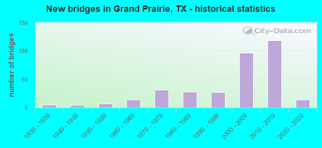
- New bridges - historical statistics
- 51930-1939
- 41940-1949
- 71950-1959
- 141960-1969
- 311970-1979
- 281980-1989
- 271990-1999
- 972000-2009
- 1192010-2019
- 142020-2022
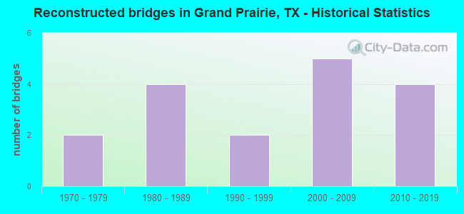
- Reconstructed bridges - Historical Statistics
- 21970-1979
- 41980-1989
- 21990-1999
- 52000-2009
- 42010-2019
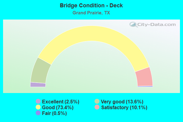
- Bridge Condition - Deck
- 2.5%Excellent
- 13.6%Very good
- 73.4%Good
- 10.1%Satisfactory
- 0.5%Fair
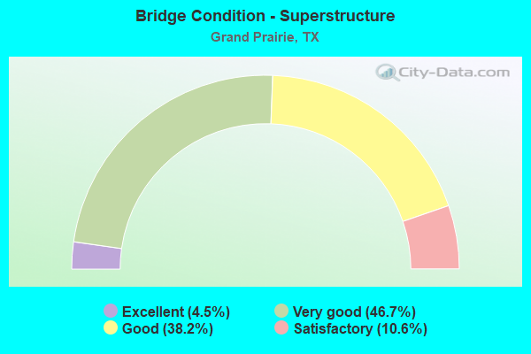
- Bridge Condition - Superstructure
- 4.5%Excellent
- 46.7%Very good
- 38.2%Good
- 10.6%Satisfactory
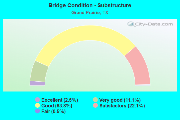
- Bridge Condition - Substructure
- 2.5%Excellent
- 11.1%Very good
- 63.8%Good
- 22.1%Satisfactory
- 0.5%Fair
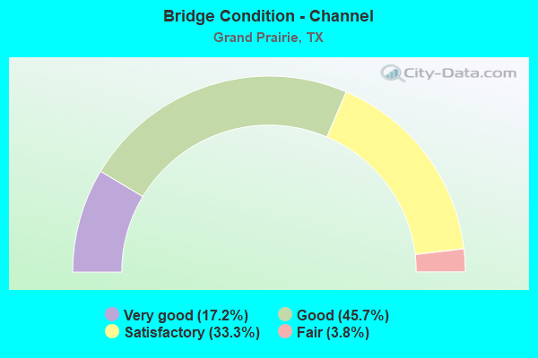
- Bridge Condition - Channel
- 17.2%Very good
- 45.7%Good
- 33.3%Satisfactory
- 3.8%Fair
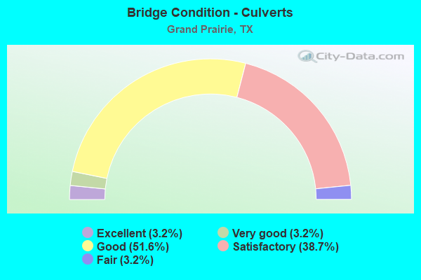
- Bridge Condition - Culverts
- 3.2%Excellent
- 3.2%Very good
- 51.6%Good
- 38.7%Satisfactory
- 3.2%Fair
Find on map >> Show street view
Structure Number: 180570F88952001, Location: 0.05 MI E OF NW 9TH ST (Lat: 32.755100, Lng: -97.014539), Route carried "on" structure: City street , Year Built: 2006, Status: Open, Structure Length: 1.28m (4.20ft), Average Daily Traffic: 600 (year 2011), Average Future Daily Traffic: 800 (year 2031), Design Load: HS 20, Features Intersected: HOLIDAY HILLS CHANNEL, Facility Carried by Structure: TURNER BLVD
Minimum Vertical Clearance: 30+ m (98+ ft), Kilometerpoint: 0.161, Lanes on structure: 2, Owner: City or Municipal Highway Agency, Approaching Roadway Width: 9.8m (32.2ft), Material/Design: Concrete continuous, Design/Construction: Slab, Number Of Spans In Main Unit: 2, Length of Maximum Span: 6.4m (21.0ft), Curb-To-Curb Width: 9.7m (31.8ft), Out-to-Out Width: 10.4m (34.1ft)
Condition: Deck: Good, Superstructure: Good, Substructure: Good, Channel: Very good, Operating Rating: 54.4 metric tons, Method Used To Determine Operating Rating: Assigned rating based on Load Factor Design (LFD) reported in metric tons, Inventory Rating: 32.7 metric tons, Method Used To Determine Inventory Rating: Assigned rating based on Load Factor Design (LFD) reported in metric tons, Structural Evaluation: Better than present minimum criteria, Deck Geometry: Equal to present minimum criteria, Waterway Adequacy: Superior to present desirable criteria, Approach Roadway Alignment: Equal to present desirable criteria, Designated Inspection Frequency: Every 24 months, Inspection Date: January 2021, Deck Structure Type: Concrete Cast-file-Place
Find on map >> Show street view
Structure Number: 180570F99010004, Location: 0.30 MI N OF CARRIER PKWY (Lat: 32.787842, Lng: -97.031475), Route carried "on" structure: City street , Year Built: 1979, Status: Open, Structure Length: 8.08m (26.51ft), Average Daily Traffic: 5,352 (year 2015), Truck Traffic: 3%, Average Future Daily Traffic: 7,493 (year 2037), Design Load: HS 20, Features Intersected: W FK TRINITY RIVER, Facility Carried by Structure: ROY ORR BLVD SB
Minimum Vertical Clearance: 30+ m (98+ ft), Kilometerpoint: 14.758, Lanes on structure: 2, Owner: City or Municipal Highway Agency, Approaching Roadway Width: 7.3m (24.0ft), Material/Design: Prestressed concrete, Design/Construction: Stringer/Multi-beam, Number Of Spans In Main Unit: 3, Length of Maximum Span: 30.5m (100.1ft), Curb-To-Curb Width: 10.4m (34.1ft), Out-to-Out Width: 10.9m (35.8ft)
Condition: Deck: Satisfactory, Superstructure: Satisfactory, Substructure: Satisfactory, Channel: Good, Operating Rating: 54.4 metric tons, Method Used To Determine Operating Rating: Assigned rating based on Load Factor Design (LFD) reported in metric tons, Inventory Rating: 32.7 metric tons, Method Used To Determine Inventory Rating: Assigned rating based on Load Factor Design (LFD) reported in metric tons, Structural Evaluation: Equal to present minimum criteria, Deck Geometry: Somewhat better than minimum adequacy, Waterway Adequacy: Superior to present desirable criteria, Approach Roadway Alignment: Equal to present desirable criteria, Designated Inspection Frequency: Every 24 months, Inspection Date: Febuary 2021, Deck Structure Type: Concrete Cast-file-Place
Find on map >> Show street view
Structure Number: 180570F99010005, Location: 0.30 MI N OF CARRIER PKWY (Lat: 32.787842, Lng: -97.031528), Route carried "on" structure: City street , Year Built: 1972, Status: Open, Structure Length: 8.08m (26.51ft), Average Daily Traffic: 5,352 (year 2015), Truck Traffic: 3%, Average Future Daily Traffic: 7,493 (year 2037), Features Intersected: WEST FORK OF TRINITY, Facility Carried by Structure: ROY ORR BLVD NB
Minimum Vertical Clearance: 30+ m (98+ ft), Kilometerpoint: 14.758, Lanes on structure: 2, Owner: City or Municipal Highway Agency, Approaching Roadway Width: 7.3m (24.0ft), Material/Design: Prestressed concrete, Design/Construction: Stringer/Multi-beam, Number Of Spans In Main Unit: 3, Length of Maximum Span: 30.5m (100.1ft), Curb-To-Curb Width: 10.4m (34.1ft), Out-to-Out Width: 10.9m (35.8ft)
Condition: Deck: Satisfactory, Superstructure: Good, Substructure: Good, Channel: Good, Operating Rating: 32.7 metric tons, Method Used To Determine Operating Rating: Field evaluation and documented engineering judgment, Inventory Rating: 24.5 metric tons, Method Used To Determine Inventory Rating: Field evaluation and documented engineering judgment, Structural Evaluation: Equal to present minimum criteria, Deck Geometry: Somewhat better than minimum adequacy, Waterway Adequacy: Superior to present desirable criteria, Approach Roadway Alignment: Equal to present desirable criteria, Designated Inspection Frequency: Every 24 months, Inspection Date: Febuary 2021, Deck Structure Type: Concrete Cast-file-Place
Find on map >> Show street view
Structure Number: 180570F99998001, Location: 1.0 MI E OF LK RIDGE PK (Lat: 32.633508, Lng: -97.030792), Route carried "on" structure: City street , Year Built: 1987, Status: Open, Structure Length: 1.13m (3.71ft), Average Daily Traffic: 650 (year 2011), Average Future Daily Traffic: 750 (year 2031), Design Load: HS 20, Features Intersected: JOE POOL LAKE TRIB, Facility Carried by Structure: MAIN RD
Minimum Vertical Clearance: 30+ m (98+ ft), Kilometerpoint: 0.805, Lanes on structure: 2, Owner: Private, Approaching Roadway Width: 8.5m (27.9ft), Skew: 4 degrees, Material/Design: Concrete, Design/Construction: Culvert, Number Of Spans In Main Unit: 4, Length of Maximum Span: 1.5m (4.9ft)
Condition: Channel: Good, Culverts: Good, Operating Rating: 39.9 metric tons, Method Used To Determine Operating Rating: Load Factor (LF), Inventory Rating: 23.6 metric tons, Method Used To Determine Inventory Rating: Load Factor (LF), Structural Evaluation: Equal to present minimum criteria, Waterway Adequacy: Better than present minimum criteria, Approach Roadway Alignment: Equal to present desirable criteria, Designated Inspection Frequency: Every 24 months, Inspection Date: April 2021
Find on map >> Show street view
Structure Number: 180570LK5528001, Location: 0.4 MI W OF S BELT LINE (Lat: 32.742236, Lng: -97.001772), Route carried "on" structure: City street , Year Built: 2009, Status: Open, Structure Length: 0.67m (2.20ft), Average Daily Traffic: 2,440 (year 2019), Truck Traffic: 3%, Average Future Daily Traffic: 3,400 (year 2039), Design Load: HS 20, Features Intersected: Henry Branch, Facility Carried by Structure: E Grand Prairie Rd
Minimum Vertical Clearance: 30+ m (98+ ft), Kilometerpoint: 0.000, Lanes on structure: 2, Owner: City or Municipal Highway Agency, Approaching Roadway Width: 9.1m (29.9ft), Skew: 3 degrees, Material/Design: Concrete, Design/Construction: Culvert, Number Of Spans In Main Unit: 2, Length of Maximum Span: 2.4m (7.9ft), Curb or Sidewalk Widths: Left: 1.2m (3.9ft), Right: 1.2m (3.9ft), Curb-To-Curb Width: 9.1m (29.9ft), Out-to-Out Width: 13.5m (44.3ft)
Condition: Channel: Good, Culverts: Good, Operating Rating: 54.4 metric tons, Method Used To Determine Operating Rating: Assigned rating based on Load Factor Design (LFD) reported in metric tons, Inventory Rating: 32.7 metric tons, Method Used To Determine Inventory Rating: Assigned rating based on Load Factor Design (LFD) reported in metric tons, Structural Evaluation: Better than present minimum criteria, Deck Geometry: Meets minimum limits, Waterway Adequacy: Better than present minimum criteria, Approach Roadway Alignment: Equal to present desirable criteria, Designated Inspection Frequency: Every 24 months, Inspection Date: April 2021, Wearing Surface/Protective System: Wearing Surface: Bituminous
Find on map >> Show street view
Structure Number: 180570LK5682001, Location: 1.3 MI SW of Lake Ridge P (Lat: 32.556564, Lng: -97.021661), Route carried "on" structure: City street , Year Built: 2008, Status: Open, Structure Length: 2.29m (7.51ft), Average Daily Traffic: 231 (year 2019), Truck Traffic: 3%, Average Future Daily Traffic: 462 (year 2039), Design Load: HS 20, Features Intersected: HOLLINGS BRANCH, Facility Carried by Structure: GLEN EAGLES DR
Minimum Vertical Clearance: 30+ m (98+ ft), Kilometerpoint: 2.092, Lanes on structure: 2, Owner: City or Municipal Highway Agency, Approaching Roadway Width: 6.7m (22.0ft), Material/Design: Concrete, Design/Construction: Culvert, Number Of Spans In Main Unit: 7, Length of Maximum Span: 3.0m (9.8ft), Curb-To-Curb Width: 8.0m (26.2ft), Out-to-Out Width: 21.9m (71.9ft)
Condition: Channel: Good, Culverts: Good, Operating Rating: 54.4 metric tons, Method Used To Determine Operating Rating: Assigned rating based on Load Factor Design (LFD) reported in metric tons, Inventory Rating: 32.7 metric tons, Method Used To Determine Inventory Rating: Assigned rating based on Load Factor Design (LFD) reported in metric tons, Structural Evaluation: Better than present minimum criteria, Deck Geometry: Somewhat better than minimum adequacy, Waterway Adequacy: Superior to present desirable criteria, Approach Roadway Alignment: Equal to present desirable criteria, Designated Inspection Frequency: Every 24 months, Inspection Date: Febuary 2021, Deck Structure Type: Concrete Cast-file-Place, Wearing Surface/Protective System: Wearing Surface: Monolithic Concrete
Find on map >> Show street view
Structure Number: 180570TL0165001, Location: 0.3 MI S of Forum Dr (Lat: 32.678647, Lng: -97.030308), Route carried "on" structure: City street , Year Built: 2014, Status: Open, Structure Length: 9.75m (31.99ft), Average Daily Traffic: 288 (year 2019), Truck Traffic: 3%, Average Future Daily Traffic: 576 (year 2039), Design Load: HL 93, Features Intersected: PRAIRIE CREEK, Facility Carried by Structure: SARA JANE PKWY
Minimum Vertical Clearance: 30+ m (98+ ft), Kilometerpoint: 0.483, Lanes on structure: 4, Owner: City or Municipal Highway Agency, Approaching Roadway Width: 15.2m (49.9ft), Skew: 9 degrees, Material/Design: Prestressed concrete, Design/Construction: Stringer/Multi-beam, Number Of Spans In Main Unit: 4, Length of Maximum Span: 24.4m (80.1ft), Curb or Sidewalk Widths: Left: 1.6m (5.2ft), Right: 1.6m (5.2ft), Curb-To-Curb Width: 15.5m (50.9ft), Out-to-Out Width: 22.1m (72.5ft)
Condition: Deck: Very good, Superstructure: Very good, Substructure: Very good, Channel: Good, Operating Rating: 54.4 metric tons, Method Used To Determine Operating Rating: Assigned ratings based on Load and Resistance Factor Design (LRFD) reported in metric tons, Inventory Rating: 32.7 metric tons, Method Used To Determine Inventory Rating: Assigned ratings based on Load and Resistance Factor Design (LRFD) reported in metric tons, Structural Evaluation: Equal to present desirable criteria, Deck Geometry: Meets minimum limits, Waterway Adequacy: Superior to present desirable criteria, Approach Roadway Alignment: Equal to present desirable criteria, Designated Inspection Frequency: Every 24 months, Inspection Date: Febuary 2021, Deck Structure Type: Concrete Cast-file-Place
Find on map >> Show street view
Structure Number: 180710017204196, Location: 4.1 MI NW OF US 67 (Lat: 32.513075, Lng: -97.067717), Route carried "on" structure: US 287, Year Built: 1997, Status: Open, Structure Length: 13.41m (44.00ft), Average Daily Traffic: 14,534 (year 2019), Truck Traffic: 12%, Average Future Daily Traffic: 21,950 (year 2033), Design Load: HS 20, Features Intersected: MOUNTAIN CREEK
Minimum Vertical Clearance: 30+ m (98+ ft), Kilometerpoint: 3.718, Lanes on structure: 2, Owner: State Highway Agency, Approaching Roadway Width: 13.4m (44.0ft), Skew: 1 degrees, Material/Design: Prestressed concrete, Design/Construction: Stringer/Multi-beam, Number Of Spans In Main Unit: 4, Number Of Approach Spans: 2, Length of Maximum Span: 24.4m (80.1ft), Curb-To-Curb Width: 13.1m (43.0ft), Out-to-Out Width: 14.0m (45.9ft)
Condition: Deck: Good, Superstructure: Very good, Substructure: Good, Channel: Satisfactory, Operating Rating: 54.4 metric tons, Method Used To Determine Operating Rating: Assigned rating based on Load Factor Design (LFD) reported in metric tons, Inventory Rating: 32.7 metric tons, Method Used To Determine Inventory Rating: Assigned rating based on Load Factor Design (LFD) reported in metric tons, Structural Evaluation: Better than present minimum criteria, Deck Geometry: Superior to present desirable criteria, Waterway Adequacy: Superior to present desirable criteria, Approach Roadway Alignment: Equal to present desirable criteria, Designated Inspection Frequency: Every 24 months, Inspection Date: September 2021, Deck Structure Type: Concrete Cast-file-Place
Find on map >> Show street view
Structure Number: 180710017204197, Location: 3.6 MI NW OF US 67 (Lat: 32.509136, Lng: -97.062133), Route carried "on" structure: US 287, Year Built: 1998, Status: Open, Structure Length: 9.14m (29.99ft), Average Daily Traffic: 17,858 (year 2019), Truck Traffic: 14%, Average Future Daily Traffic: 18,510 (year 2033), Design Load: HS 20, Features Intersected: SOAP CREEK
Minimum Vertical Clearance: 30+ m (98+ ft), Kilometerpoint: 4.379, Lanes on structure: 3, Owner: State Highway Agency, Approaching Roadway Width: 12.2m (40.0ft), Material/Design: Prestressed concrete, Design/Construction: Stringer/Multi-beam, Number Of Spans In Main Unit: 4, Length of Maximum Span: 22.9m (75.1ft), Curb-To-Curb Width: 16.2m (53.1ft), Out-to-Out Width: 17.1m (56.1ft)
Condition: Deck: Good, Superstructure: Good, Substructure: Good, Channel: Good, Operating Rating: 54.4 metric tons, Method Used To Determine Operating Rating: Assigned rating based on Load Factor Design (LFD) reported in metric tons, Inventory Rating: 32.7 metric tons, Method Used To Determine Inventory Rating: Assigned rating based on Load Factor Design (LFD) reported in metric tons, Structural Evaluation: Better than present minimum criteria, Deck Geometry: Better than present minimum criteria, Waterway Adequacy: Superior to present desirable criteria, Approach Roadway Alignment: Equal to present desirable criteria, Designated Inspection Frequency: Every 24 months, Inspection Date: September 2021, Deck Structure Type: Concrete Cast-file-Place
Find on map >> Show street view
Structure Number: 180710017204202, Location: 4.0 MI NW OF US 67 (Lat: 32.512839, Lng: -97.067036), Route carried "on" structure: US 287, Year Built: 2005, Status: Open, Structure Length: 13.41m (44.00ft), Average Daily Traffic: 14,859 (year 2019), Truck Traffic: 12%, Average Future Daily Traffic: 21,950 (year 2033), Design Load: HS 20, Features Intersected: MOUNTAIN CREEK
Minimum Vertical Clearance: 30+ m (98+ ft), Kilometerpoint: 3.695, Lanes on structure: 2, Owner: State Highway Agency, Approaching Roadway Width: 11.6m (38.1ft), Skew: 1 degrees, Material/Design: Prestressed concrete, Design/Construction: Stringer/Multi-beam, Number Of Spans In Main Unit: 6, Length of Maximum Span: 24.4m (80.1ft), Curb-To-Curb Width: 11.2m (36.7ft), Out-to-Out Width: 12.0m (39.4ft)
Condition: Deck: Good, Superstructure: Very good, Substructure: Good, Channel: Satisfactory, Operating Rating: 54.4 metric tons, Method Used To Determine Operating Rating: Assigned rating based on Load Factor Design (LFD) reported in metric tons, Inventory Rating: 32.7 metric tons, Method Used To Determine Inventory Rating: Assigned rating based on Load Factor Design (LFD) reported in metric tons, Structural Evaluation: Better than present minimum criteria, Deck Geometry: Equal to present minimum criteria, Waterway Adequacy: Superior to present desirable criteria, Approach Roadway Alignment: Equal to present desirable criteria, Designated Inspection Frequency: Every 24 months, Inspection Date: September 2021, Deck Structure Type: Concrete Cast-file-Place
Find on map >> Show street view
Structure Number: 180710017204204, Location: 3.05 MI NW OF US 67 (Lat: 32.504242, Lng: -97.055006), Route carried "on" structure: US 287, Year Built: 2003, Status: Open, Structure Length: 7.19m (23.59ft), Average Daily Traffic: 21,187 (year 2020), Truck Traffic: 14%, Average Future Daily Traffic: 18,510 (year 2033), Design Load: HS 20, Features Intersected: COTTONWOOD CREEK
Minimum Vertical Clearance: 30+ m (98+ ft), Kilometerpoint: 5.325, Lanes on structure: 2, Owner: State Highway Agency, Approaching Roadway Width: 11.3m (37.1ft), Material/Design: Prestressed concrete, Design/Construction: Stringer/Multi-beam, Number Of Spans In Main Unit: 3, Length of Maximum Span: 24.1m (79.1ft), Curb-To-Curb Width: 11.1m (36.4ft), Out-to-Out Width: 12.0m (39.4ft)
Condition: Deck: Satisfactory, Superstructure: Very good, Substructure: Good, Channel: Good, Operating Rating: 54.4 metric tons, Method Used To Determine Operating Rating: Assigned rating based on Load Factor Design (LFD) reported in metric tons, Inventory Rating: 32.7 metric tons, Method Used To Determine Inventory Rating: Assigned rating based on Load Factor Design (LFD) reported in metric tons, Structural Evaluation: Better than present minimum criteria, Deck Geometry: Equal to present minimum criteria, Waterway Adequacy: Superior to present desirable criteria, Approach Roadway Alignment: Equal to present desirable criteria, Designated Inspection Frequency: Every 24 months, Inspection Date: September 2021, Deck Structure Type: Concrete Cast-file-Place
Find on map >> Show street view
Structure Number: 180710017204205, Location: 3.05 MI NW OF US 67 (Lat: 32.504019, Lng: -97.055225), Route carried "on" structure: US 287, Year Built: 2003, Status: Open, Structure Length: 7.19m (23.59ft), Average Daily Traffic: 17,858 (year 2019), Truck Traffic: 14%, Average Future Daily Traffic: 18,510 (year 2033), Design Load: HS 20, Features Intersected: COTTONWOOD CREEK
Minimum Vertical Clearance: 30+ m (98+ ft), Kilometerpoint: 5.325, Lanes on structure: 2, Owner: State Highway Agency, Approaching Roadway Width: 11.3m (37.1ft), Material/Design: Prestressed concrete, Design/Construction: Stringer/Multi-beam, Number Of Spans In Main Unit: 3, Length of Maximum Span: 24.1m (79.1ft), Curb-To-Curb Width: 11.4m (37.4ft), Out-to-Out Width: 12.3m (40.4ft)
Condition: Deck: Good, Superstructure: Good, Substructure: Good, Channel: Good, Operating Rating: 54.4 metric tons, Method Used To Determine Operating Rating: Assigned rating based on Load Factor Design (LFD) reported in metric tons, Inventory Rating: 32.7 metric tons, Method Used To Determine Inventory Rating: Assigned rating based on Load Factor Design (LFD) reported in metric tons, Structural Evaluation: Better than present minimum criteria, Deck Geometry: Equal to present minimum criteria, Waterway Adequacy: Superior to present desirable criteria, Approach Roadway Alignment: Equal to present desirable criteria, Designated Inspection Frequency: Every 24 months, Inspection Date: September 2021, Deck Structure Type: Concrete Cast-file-Place
Find on map >> Show street view
Structure Number: 180710017204206, Location: 3.6 MI NW OF US 67 (Lat: 32.509328, Lng: -97.061936), Route carried "on" structure: US 287, Year Built: 2005, Status: Open, Structure Length: 9.14m (29.99ft), Average Daily Traffic: 21,187 (year 2020), Truck Traffic: 14%, Average Future Daily Traffic: 18,510 (year 2033), Design Load: HS 20, Features Intersected: SOAP CREEK
Minimum Vertical Clearance: 30+ m (98+ ft), Kilometerpoint: 4.443, Lanes on structure: 2, Owner: State Highway Agency, Approaching Roadway Width: 11.6m (38.1ft), Material/Design: Prestressed concrete, Design/Construction: Stringer/Multi-beam, Number Of Spans In Main Unit: 2, Number Of Approach Spans: 1, Length of Maximum Span: 38.1m (125.0ft), Curb-To-Curb Width: 11.2m (36.7ft), Out-to-Out Width: 12.0m (39.4ft)
Condition: Deck: Good, Superstructure: Very good, Substructure: Good, Channel: Good, Operating Rating: 54.4 metric tons, Method Used To Determine Operating Rating: Assigned rating based on Load Factor Design (LFD) reported in metric tons, Inventory Rating: 32.7 metric tons, Method Used To Determine Inventory Rating: Assigned rating based on Load Factor Design (LFD) reported in metric tons, Structural Evaluation: Better than present minimum criteria, Deck Geometry: Equal to present minimum criteria, Waterway Adequacy: Superior to present desirable criteria, Approach Roadway Alignment: Equal to present desirable criteria, Designated Inspection Frequency: Every 24 months, Inspection Date: September 2021, Deck Structure Type: Concrete Cast-file-Place
Find on map >> Show street view
Structure Number: 180710104901004, Location: 1.00 MI N OF US 287 (Lat: 32.525717, Lng: -97.064553), Route carried "on" structure: State highway 661, Year Built: 1960, Status: Open, Structure Length: 9.14m (29.99ft), Average Daily Traffic: 1,089 (year 2020), Truck Traffic: 6%, Average Future Daily Traffic: 1,110 (year 2033), Design Load: H 15, Features Intersected: MOUNTAIN CREEK
Minimum Vertical Clearance: 30+ m (98+ ft), Kilometerpoint: 4.390, Lanes on structure: 2, Owner: State Highway Agency, Approaching Roadway Width: 7.3m (24.0ft), Material/Design: Concrete, Design/Construction: Stringer/Multi-beam, Number Of Spans In Main Unit: 10, Length of Maximum Span: 9.1m (29.9ft), Curb-To-Curb Width: 6.9m (22.6ft), Out-to-Out Width: 7.5m (24.6ft)
Condition: Deck: Good, Superstructure: Good, Substructure: Satisfactory, Channel: Fair, Operating Rating: 53.5 metric tons, Method Used To Determine Operating Rating: Load Factor (LF), Inventory Rating: 31.7 metric tons, Method Used To Determine Inventory Rating: Load Factor (LF), Structural Evaluation: Equal to present minimum criteria, Deck Geometry: High priority of corrective action, Waterway Adequacy: High priority of corrective action, Approach Roadway Alignment: Better than present minimum criteria, Length Of Structure Improvement: 9.14m (29.99ft), Designated Inspection Frequency: Every 24 months, Inspection Date: September 2021, Bridge Improvement Cost: $14,000, Roadway Improvement Cost: $4,000, Total Project Cost: $18,000, Deck Structure Type: Concrete Cast-file-Place, Wearing Surface/Protective System: Wearing Surface: Bituminous
Find on map >> Show street view
Structure Number: 180710104901008, Location: 2.6 MI N OF US 287 (Lat: 32.546897, Lng: -97.064272), Route carried "on" structure: State highway 661, Year Built: 1985, Status: Open, Structure Length: 4.88m (16.01ft), Average Daily Traffic: 904 (year 2014), Truck Traffic: 6%, Average Future Daily Traffic: 960 (year 2033), Design Load: HS 20, Features Intersected: BRITTON CREEK
Minimum Vertical Clearance: 30+ m (98+ ft), Kilometerpoint: 1.986, Lanes on structure: 2, Owner: State Highway Agency, Approaching Roadway Width: 7.0m (23.0ft), Skew: 2 degrees, Material/Design: Concrete, Design/Construction: Stringer/Multi-beam, Number Of Spans In Main Unit: 5, Length of Maximum Span: 9.8m (32.2ft), Curb-To-Curb Width: 8.7m (28.5ft), Out-to-Out Width: 9.0m (29.5ft)
Condition: Deck: Good, Superstructure: Good, Substructure: Good, Channel: Satisfactory, Operating Rating: 54.4 metric tons, Method Used To Determine Operating Rating: Assigned rating based on Load Factor Design (LFD) reported in metric tons, Inventory Rating: 32.7 metric tons, Method Used To Determine Inventory Rating: Assigned rating based on Load Factor Design (LFD) reported in metric tons, Structural Evaluation: Better than present minimum criteria, Deck Geometry: Somewhat better than minimum adequacy, Waterway Adequacy: Superior to present desirable criteria, Approach Roadway Alignment: Equal to present desirable criteria, Designated Inspection Frequency: Every 24 months, Inspection Date: September 2021, Deck Structure Type: Concrete Cast-file-Place, Wearing Surface/Protective System: Wearing Surface: Bituminous
Find on map >> Show street view
Structure Number: 180710LI0993002, Location: 0.70 MI SW OF US 287 (Lat: 32.501994, Lng: -97.069392), Route carried "on" structure: City street , Year Built: 2009, Status: Open, Structure Length: 8.11m (26.61ft), Average Daily Traffic: 280 (year 2019), Truck Traffic: 3%, Average Future Daily Traffic: 392 (year 2039), Features Intersected: SOAP CREEK, Facility Carried by Structure: PRAIRIE RIDGE WB
Minimum Vertical Clearance: 30+ m (98+ ft), Kilometerpoint: 1.127, Lanes on structure: 2, Owner: City or Municipal Highway Agency, Approaching Roadway Width: 7.3m (24.0ft), Skew: 1 degrees, Material/Design: Prestressed concrete, Design/Construction: Box Beam or Girders - Multiple, Number Of Spans In Main Unit: 5, Length of Maximum Span: 16.2m (53.1ft), Curb or Sidewalk Widths: Left: 1.9m (6.2ft), Right: 0.0m, Curb-To-Curb Width: 7.4m (24.3ft), Out-to-Out Width: 10.3m (33.8ft)
Condition: Deck: Good, Superstructure: Very good, Substructure: Good, Channel: Good, Operating Rating: 32.7 metric tons, Method Used To Determine Operating Rating: Field evaluation and documented engineering judgment, Inventory Rating: 24.5 metric tons, Method Used To Determine Inventory Rating: Field evaluation and documented engineering judgment, Structural Evaluation: Equal to present minimum criteria, Deck Geometry: High priority of replacement, Waterway Adequacy: Equal to present minimum criteria, Approach Roadway Alignment: Equal to present desirable criteria, Designated Inspection Frequency: Every 24 months, Inspection Date: June 2021, Deck Structure Type: Concrete Cast-file-Place
Find on map >> Show street view
Structure Number: 180710LI0993003, Location: 0.70 MI SW OF US 287 (Lat: 32.501667, Lng: -97.069950), Route carried "on" structure: City street , Year Built: 2009, Status: Open, Structure Length: 8.11m (26.61ft), Average Daily Traffic: 280 (year 2019), Truck Traffic: 2%, Average Future Daily Traffic: 392 (year 2039), Features Intersected: SOAP CREEK, Facility Carried by Structure: PRAIRIE RIDGE EB
Minimum Vertical Clearance: 30+ m (98+ ft), Kilometerpoint: 1.127, Lanes on structure: 2, Owner: City or Municipal Highway Agency, Approaching Roadway Width: 7.3m (24.0ft), Skew: 1 degrees, Material/Design: Prestressed concrete, Design/Construction: Box Beam or Girders - Multiple, Number Of Spans In Main Unit: 5, Length of Maximum Span: 16.2m (53.1ft), Curb or Sidewalk Widths: Left: 0.0m, Right: 2.8m (9.2ft), Curb-To-Curb Width: 7.4m (24.3ft), Out-to-Out Width: 11.2m (36.7ft)
Condition: Deck: Good, Superstructure: Good, Substructure: Good, Channel: Good, Operating Rating: 32.7 metric tons, Method Used To Determine Operating Rating: Field evaluation and documented engineering judgment, Inventory Rating: 24.5 metric tons, Method Used To Determine Inventory Rating: Field evaluation and documented engineering judgment, Structural Evaluation: Equal to present minimum criteria, Deck Geometry: High priority of replacement, Waterway Adequacy: Equal to present minimum criteria, Approach Roadway Alignment: Equal to present desirable criteria, Designated Inspection Frequency: Every 24 months, Inspection Date: June 2021, Deck Structure Type: Concrete Cast-file-Place
Find on map >> Show street view
Structure Number: 22200106802307, Location: 1.5 MI E OF SH-360 (Lat: 32.759522, Lng: -97.037025), Route carried "under" structure: Interstate 30, Year Built: 2009, Structure Length: 0. m, Average Daily Traffic: 94,000 (year 2013), Truck Traffic: 8%, Features Intersected: IH 30, Facility Carried by Structure: DUNCAN-PERRY ROAD
Minimum Vertical Clearance: 5.33m (17.49ft), Kilometerpoint: 49.515, Material/Design: Prestressed concrete, Design/Construction: Stringer/Multi-beam, Length of Maximum Span: 35.1m (115.2ft)
Find on map >> Show street view
Structure Number: 22200226602002, Location: 2.2 MI S OF SH-183 (Lat: 32.805308, Lng: -97.053517), Route carried "under" structure: City street , Year Built: 1958, Structure Length: 0. m, Average Daily Traffic: 3,040 (year 2009), Features Intersected: RIVERSIDE PARKWAY, Facility Carried by Structure: SH 360 NB
Minimum Vertical Clearance: 4.65m (15.26ft), Kilometerpoint: 5.478, Lanes on structure: 3, Lanes under structure: 7, Material/Design: Prestressed concrete, Design/Construction: Stringer/Multi-beam, Length of Maximum Span: 19.8m (65.0ft)
Find on map >> Show street view
Structure Number: 22200226602012, Location: 1.1 MI S OF IH-20 (Lat: 32.660883, Lng: -97.062314), Route carried "under" structure: City street , Year Built: 2006, Structure Length: 0. m, Average Daily Traffic: 18,360 (year 2009), Features Intersected: SE GREEN OAKS/FISH CREEK, Facility Carried by Structure: SH 360 NB
Minimum Vertical Clearance: 5.03m (16.50ft), Kilometerpoint: 5.633, Lanes on structure: 2, Lanes under structure: 9, Material/Design: Steel continuous, Design/Construction: Stringer/Multi-beam, Length of Maximum Span: 80.8m (265.1ft)
Find on map >> Show street view
Structure Number: 22200226602019, Location: 2.2 MI S OF SH-183 (Lat: 32.805308, Lng: -97.053631), Route carried "under" structure: City street , Year Built: 1973, Structure Length: 0. m, Average Daily Traffic: 3,040 (year 2009), Features Intersected: RIVERSIDE PARKWAY, Facility Carried by Structure: SH 360 SB
Minimum Vertical Clearance: 4.65m (15.26ft), Kilometerpoint: 5.478, Lanes on structure: 3, Lanes under structure: 7, Material/Design: Prestressed concrete, Design/Construction: Stringer/Multi-beam, Length of Maximum Span: 19.8m (65.0ft)
Find on map >> Show street view
Structure Number: 22200226602046, Location: 3.16 MI S OF SH 183 (Lat: 32.793364, Lng: -97.056697), Route carried "under" structure: State highway 360, Year Built: 1986, Structure Length: 0. m, Average Daily Traffic: 133,170 (year 2013), Truck Traffic: 5%, Features Intersected: SH-360, Facility Carried by Structure: POST & PADDOCK RD
Minimum Vertical Clearance: 4.98m (16.34ft), Kilometerpoint: 14.571, Lanes on structure: 6, Lanes under structure: 6, Material/Design: Prestressed concrete, Design/Construction: Stringer/Multi-beam, Length of Maximum Span: 25.0m (82.0ft)
Find on map >> Show street view
Structure Number: 22200226602047, Location: 3.73 MI S OF SH 183 (Lat: 32.785300, Lng: -97.059000), Route carried "under" structure: State highway 360, Year Built: 1986, Structure Length: 0. m, Average Daily Traffic: 133,170 (year 2013), Truck Traffic: 5%, Features Intersected: SH-360, Facility Carried by Structure: W N. CARRIER PKWY
Minimum Vertical Clearance: 5.23m (17.16ft), Kilometerpoint: 15.474, Material/Design: Prestressed concrete, Design/Construction: Stringer/Multi-beam, Length of Maximum Span: 38.1m (125.0ft)
Find on map >> Show street view
Structure Number: 22200226602048, Location: 4.2 MI S OF SH-183 (Lat: 32.778961, Lng: -97.060844), Route carried "under" structure: City street , Year Built: 1986, Structure Length: 0. m, Average Daily Traffic: 5,490 (year 2009), Features Intersected: FOUNTAIN PARKWAY, Facility Carried by Structure: SH360 NBL
Minimum Vertical Clearance: 5.05m (16.57ft), Kilometerpoint: 0.805, Lanes on structure: 4, Lanes under structure: 6, Material/Design: Prestressed concrete, Design/Construction: Stringer/Multi-beam, Length of Maximum Span: 28.7m (94.2ft)
Find on map >> Show street view
Structure Number: 22200226602053, Location: 1.1 MI S OF IH-20 (Lat: 32.660592, Lng: -97.062628), Route carried "under" structure: City street , Year Built: 2006, Structure Length: 0. m, Average Daily Traffic: 18,360 (year 2009), Features Intersected: SE GREEN OAKS/FISH CREEK, Facility Carried by Structure: SH 360 SB
Minimum Vertical Clearance: 5.03m (16.50ft), Kilometerpoint: 5.633, Lanes on structure: 2, Lanes under structure: 9, Material/Design: Steel continuous, Design/Construction: Stringer/Multi-beam, Length of Maximum Span: 80.8m (265.1ft)
Find on map >> Show street view
Structure Number: 22200226602055, Location: 4.19 MI S OF SH 183 (Lat: 32.778961, Lng: -97.060978), Route carried "under" structure: City street , Year Built: 1986, Structure Length: 0. m, Average Daily Traffic: 5,490 (year 2009), Features Intersected: FOUNTAIN PARKWAY, Facility Carried by Structure: SH360 SBL
Minimum Vertical Clearance: 6.04m (19.82ft), Kilometerpoint: 0.805, Lanes on structure: 4, Lanes under structure: 6, Material/Design: Prestressed concrete, Design/Construction: Stringer/Multi-beam, Length of Maximum Span: 28.7m (94.2ft)
Find on map >> Show street view
Structure Number: 22200226602122, Location: 2.0 Mi. S. of IH20 (Lat: 32.648500, Lng: -97.062800), Route carried "under" structure: State highway 360, Year Built: 2017, Structure Length: 0. m, Average Daily Traffic: 24,720 (year 2020), Truck Traffic: 5%, Features Intersected: SH 360 NTTA
Minimum Vertical Clearance: 5.26m (17.26ft), Kilometerpoint: 30.663, Lanes on structure: 1, Lanes under structure: 6, Toll: On toll road, Material/Design: Prestressed concrete, Design/Construction: Stringer/Multi-beam, Length of Maximum Span: 40.2m (131.9ft)
Find on map >> Show street view
Structure Number: 22200226602123, Location: 2.0 Mi. S. of IH20 (Lat: 32.648400, Lng: -97.062700), Route carried "under" structure: State highway 360, Year Built: 2017, Structure Length: 0. m, Average Daily Traffic: 24,720 (year 2020), Truck Traffic: 5%, Features Intersected: SH 360 NTTA, Facility Carried by Structure: Camp Wisdom Rd.
Minimum Vertical Clearance: 5.24m (17.19ft), Kilometerpoint: 30.672, Lanes on structure: 8, Lanes under structure: 6, Toll: On toll road, Material/Design: Prestressed concrete, Design/Construction: Stringer/Multi-beam, Length of Maximum Span: 40.2m (131.9ft)
Find on map >> Show street view
Structure Number: 22200226602124, Location: 2.0 Mi. S. of IH20 (Lat: 32.648300, Lng: -97.061800), Route carried "under" structure: State highway 360, Year Built: 2017, Structure Length: 0. m, Average Daily Traffic: 24,720 (year 2020), Truck Traffic: 5%, Features Intersected: SH 360 NTTA
Minimum Vertical Clearance: 5.24m (17.19ft), Kilometerpoint: 30.672, Lanes on structure: 1, Lanes under structure: 6, Toll: On toll road, Material/Design: Prestressed concrete, Design/Construction: Stringer/Multi-beam, Length of Maximum Span: 40.2m (131.9ft)
Find on map >> Show street view
Structure Number: 22200226602125, Location: 0.9 Mi. S. of Camp Wisdom (Lat: 32.635700, Lng: -97.064700), Route carried "under" structure: State highway 360, Year Built: 2017, Structure Length: 0. m, Average Daily Traffic: 24,720 (year 2020), Truck Traffic: 5%, Features Intersected: SH 360 NTTA, Facility Carried by Structure: Lynn EB WB and TA
Minimum Vertical Clearance: 5.58m (18.31ft), Kilometerpoint: 32.118, Lanes on structure: 7, Lanes under structure: 5, Toll: On toll road, Material/Design: Prestressed concrete, Design/Construction: Stringer/Multi-beam, Length of Maximum Span: 33.8m (110.9ft)
Find on map >> Show street view
Structure Number: 22200226602126, Location: 0.9 Mi. S. of Camp Wisdom (Lat: 32.635500, Lng: -97.063900), Route carried "under" structure: State highway 360, Year Built: 2017, Structure Length: 0. m, Average Daily Traffic: 24,720 (year 2020), Truck Traffic: 5%, Features Intersected: SH 360 NTTA
Minimum Vertical Clearance: 5.59m (18.34ft), Kilometerpoint: 32.121, Lanes on structure: 1, Lanes under structure: 5, Toll: On toll road, Material/Design: Prestressed concrete, Design/Construction: Stringer/Multi-beam, Length of Maximum Span: 33.8m (110.9ft)
Find on map >> Show street view
Structure Number: 22200226602127, Location: 0.8 Mi. S. of Lynn Creek (Lat: 32.625900, Lng: -97.069900), Route carried "under" structure: City street , Year Built: 2017, Structure Length: 0. m, Average Daily Traffic: 5,000 (year 2020), Features Intersected: New York Ave., Facility Carried by Structure: SH 360 NB
Minimum Vertical Clearance: 5.56m (18.24ft), Kilometerpoint: 33.354, Lanes on structure: 3, Lanes under structure: 8, Material/Design: Prestressed concrete, Design/Construction: Stringer/Multi-beam, Length of Maximum Span: 41.8m (137.1ft)
Find on map >> Show street view
Structure Number: 22200226602128, Location: 0.8 Mi. S. of Lynn Creek (Lat: 32.626600, Lng: -97.069700), Route carried "under" structure: City street , Year Built: 2017, Structure Length: 0. m, Average Daily Traffic: 5,000 (year 2020), Features Intersected: New York Ave., Facility Carried by Structure: SH 360 SB
Minimum Vertical Clearance: 5.59m (18.34ft), Kilometerpoint: 33.278, Lanes on structure: 3, Lanes under structure: 8, Material/Design: Prestressed concrete, Design/Construction: Stringer/Multi-beam, Length of Maximum Span: 43.0m (141.1ft)
Find on map >> Show street view
Structure Number: 22200226602132, Location: 2.3 Mi. N. of Broad St. (Lat: 32.609900, Lng: -97.077200), Route carried "under" structure: State highway 360, Year Built: 2017, Structure Length: 0. m, Average Daily Traffic: 24,720 (year 2020), Truck Traffic: 5%, Features Intersected: SH 360 NTTA, Facility Carried by Structure: Ragland WB NBTA
Minimum Vertical Clearance: 5.15m (16.90ft), Kilometerpoint: 35.278, Lanes on structure: 4, Lanes under structure: 6, Toll: On toll road, Material/Design: Prestressed concrete, Design/Construction: Stringer/Multi-beam, Length of Maximum Span: 39.9m (130.9ft)
Find on map >> Show street view
Structure Number: 22200226602133, Location: 2.2 Mi. N. of Broad St. (Lat: 32.609600, Lng: -97.076500), Route carried "under" structure: State highway 360, Year Built: 2017, Structure Length: 0. m, Average Daily Traffic: 24,720 (year 2020), Truck Traffic: 5%, Features Intersected: SH 360 NTTA, Facility Carried by Structure: Ragland EB SBTA
Minimum Vertical Clearance: 5.15m (16.90ft), Kilometerpoint: 35.288, Lanes on structure: 4, Lanes under structure: 6, Toll: On toll road, Material/Design: Prestressed concrete, Design/Construction: Stringer/Multi-beam, Length of Maximum Span: 39.9m (130.9ft)
Find on map >> Show street view
Structure Number: 22200237405296, Location: 1.1 MI E OF SH-360 (Lat: 32.676500, Lng: -97.043900), Route carried "under" structure: City street 673, Year Built: 1975, Structure Length: 0. m, Average Daily Traffic: 26,585 (year 2009), Features Intersected: GREAT SW PARKWAY, Facility Carried by Structure: IH20 WBL
Minimum Vertical Clearance: 4.75m (15.58ft), Kilometerpoint: 8.047, Material/Design: Prestressed concrete, Design/Construction: Stringer/Multi-beam, Length of Maximum Span: 20.1m (65.9ft)
Find on map >> Show street view
Structure Number: 22200237405297, Location: 1.1 MI E OF SH-360 (Lat: 32.676100, Lng: -97.044700), Route carried "under" structure: City street 673, Year Built: 1975, Structure Length: 0. m, Average Daily Traffic: 26,585 (year 2009), Features Intersected: GREAT SW PARKWAY, Facility Carried by Structure: IH20 EBL
Minimum Vertical Clearance: 4.85m (15.91ft), Kilometerpoint: 8.047, Material/Design: Prestressed concrete, Design/Construction: Stringer/Multi-beam, Length of Maximum Span: 20.1m (65.9ft)
Structure Number: 180570000808003, Location: 0.8 Mi S of IH 30, Route carried "under" structure: State highway 180, Year Built: 2012, Structure Length: 0. m, Average Daily Traffic: 12,510 (year 2013), Truck Traffic: 5%, Features Intersected: SH 180 UPRR Jefferson, Facility Carried by Structure: FM1382 Belt Line
Minimum Vertical Clearance: 5.74m (18.83ft), Kilometerpoint: 0.000, Lanes on structure: 6, Lanes under structure: 12, Material/Design: Prestressed concrete, Design/Construction: Stringer/Multi-beam, Length of Maximum Span: 37.5m (123.0ft)
Minimum Vertical Clearance: 5.74m (18.83ft), Kilometerpoint: 0.000, Lanes on structure: 6, Lanes under structure: 12, Material/Design: Prestressed concrete, Design/Construction: Stringer/Multi-beam, Length of Maximum Span: 37.5m (123.0ft)
Find on map >> Show street view
Structure Number: 180570000808137, Location: 1.25 MI W of FM 1382 (Lat: 32.742522, Lng: -97.015611), Route carried "under" structure: Alternate City street , Year Built: 1963, Structure Length: 0. m, Average Daily Traffic: 2,143 (year 2011), Features Intersected: Carrier Parkway, Facility Carried by Structure: SH 180
Minimum Vertical Clearance: 4.37m (14.34ft), Kilometerpoint: 14.828, Lanes on structure: 5, Lanes under structure: 4, Material/Design: Prestressed concrete, Design/Construction: Stringer/Multi-beam, Length of Maximum Span: 14.0m (45.9ft)
Find on map >> Show street view
Structure Number: 180570106804022, Location: 2.03 MI W OF BELT LINE RD (Lat: 32.759714, Lng: -97.029869), Route carried "under" structure: Interstate 30, Year Built: 2008, Structure Length: 0. m, Average Daily Traffic: 98,650 (year 2010), Truck Traffic: 10%, Features Intersected: SH 161 SBFR, Facility Carried by Structure: SH 161 SBFR
Minimum Vertical Clearance: 5.59m (18.34ft), Kilometerpoint: 0.000, Lanes on structure: 8, Material/Design: Prestressed concrete, Design/Construction: Stringer/Multi-beam, Length of Maximum Span: 38.1m (125.0ft)
Find on map >> Show street view
Structure Number: 180570106804183, Location: 2.0 MI E OF BELT LINE RD (Lat: 32.762431, Lng: -96.959981), Route carried "under" structure: City street , Year Built: 1994, Structure Length: 0. m, Average Daily Traffic: 1,900 (year 2011), Features Intersected: IH 30, Facility Carried by Structure: IH 30
Minimum Vertical Clearance: 4.97m (16.31ft), Kilometerpoint: 43.702, Lanes on structure: 8, Material/Design: Prestressed concrete, Design/Construction: Stringer/Multi-beam, Length of Maximum Span: 36.6m (120.1ft)
Find on map >> Show street view
Structure Number: 180570106804206, Location: 2.0 MI E OF NW 19TH ST (Lat: 32.757958, Lng: -96.994792), Route carried "under" structure: City street , Year Built: 2001, Structure Length: 0. m, Average Daily Traffic: 12,489 (year 2011), Features Intersected: IH 30, Facility Carried by Structure: IH 30
Minimum Vertical Clearance: 5.16m (16.93ft), Kilometerpoint: 38.861, Lanes on structure: 10, Material/Design: Prestressed concrete, Design/Construction: Stringer/Multi-beam, Length of Maximum Span: 36.9m (121.1ft)
Find on map >> Show street view
Structure Number: 180570106804298, Location: 1.45 MI W OF BELT LINE RD (Lat: 32.759733, Lng: -97.019547), Route carried "under" structure: Interstate 30, Year Built: 2006, Structure Length: 0. m, Average Daily Traffic: 108,580 (year 2013), Truck Traffic: 8%, Features Intersected: CARRIER PARKWAY, Facility Carried by Structure: CARRIER PARKWAY
Minimum Vertical Clearance: 6.12m (20.08ft), Kilometerpoint: 1.482, Lanes on structure: 10, Material/Design: Prestressed concrete, Design/Construction: Stringer/Multi-beam, Length of Maximum Span: 40.2m (131.9ft)
Find on map >> Show street view
Structure Number: 180570106804299, Location: 1.0 MI WEST OF BELT LINE (Lat: 32.759731, Lng: -97.012394), Route carried "under" structure: City street , Year Built: 2005, Structure Length: 0. m, Average Daily Traffic: 1,200 (year 2011), Features Intersected: IH 30, Facility Carried by Structure: IH 30
Minimum Vertical Clearance: 5.11m (16.77ft), Kilometerpoint: 1.609, Lanes on structure: 5, Material/Design: Prestressed concrete, Design/Construction: Stringer/Multi-beam, Length of Maximum Span: 28.0m (91.9ft)
Find on map >> Show street view
Structure Number: 180570106804303, Location: 1.97 MI W OF BELT LINE RD (Lat: 32.759328, Lng: -97.028972), Route carried "under" structure: State highway 161, Year Built: 2012, Structure Length: 0. m, Average Daily Traffic: 2,400 (year 2010), Truck Traffic: 5%, Features Intersected: IH 30, Facility Carried by Structure: IH 30
Minimum Vertical Clearance: 6.27m (20.57ft), Kilometerpoint: 0.000, Lanes on structure: 6, Material/Design: Prestressed concrete, Design/Construction: Stringer/Multi-beam, Length of Maximum Span: 36.9m (121.1ft)
Find on map >> Show street view
Structure Number: 180570106804304, Location: 2.0 MI W OF BELT LINE RD (Lat: 32.759356, Lng: -97.028578), Route carried "under" structure: Interstate 30, Year Built: 2007, Structure Length: 0. m, Average Daily Traffic: 108,580 (year 2013), Truck Traffic: 8%, Features Intersected: NW 19/SH 161 NBFR, Facility Carried by Structure: NW 19/ SH 161 NBFR
Minimum Vertical Clearance: 5.84m (19.16ft), Kilometerpoint: 0.658, Lanes on structure: 8, Material/Design: Prestressed concrete, Design/Construction: Stringer/Multi-beam, Length of Maximum Span: 34.1m (111.9ft)
Find on map >> Show street view
Structure Number: 180570106804513, Location: IH 30 & SH 161 I/C (Lat: 32.756944, Lng: -97.029722), Route carried "under" structure: Interstate 30, Year Built: 2012, Structure Length: 0. m, Average Daily Traffic: 15,000 (year 2016), Truck Traffic: 1%, Features Intersected: IH 30 & SH 161 I/C
Minimum Vertical Clearance: 11.58m (37.99ft), Kilometerpoint: 0.660, Lanes on structure: 22, Material/Design: Steel continuous, Design/Construction: Stringer/Multi-beam, Length of Maximum Span: 75.0m (246.1ft)
Find on map >> Show street view
Structure Number: 180570106804514, Location: IH 30 & SH 161 I/C (Lat: 32.765861, Lng: -97.029425), Route carried "under" structure: Interstate 30, Year Built: 2013, Structure Length: 0. m, Average Daily Traffic: 197,696 (year 2020), Truck Traffic: 10%, Features Intersected: IH 30 & SH 161 I/C, Facility Carried by Structure: SH 161 SB CONN E
Minimum Vertical Clearance: 13.72m (45.01ft), Kilometerpoint: 0.692, Lanes on structure: 1, Lanes under structure: 27, Material/Design: Steel continuous, Design/Construction: Stringer/Multi-beam, Length of Maximum Span: 77.1m (253.0ft)
Find on map >> Show street view
Structure Number: 180570106804515, Location: IH 30 & SH 161 I/C (Lat: 32.759117, Lng: -97.033017), Route carried "under" structure: Interstate 30, Year Built: 2013, Structure Length: 0. m, Average Daily Traffic: 98,848 (year 2020), Truck Traffic: 10%, Features Intersected: IH 30 & SH 161 I/C
Minimum Vertical Clearance: 21.95m (72.01ft), Kilometerpoint: 0.451, Lanes on structure: 8, Lanes under structure: 20, Material/Design: Steel continuous, Design/Construction: Stringer/Multi-beam, Length of Maximum Span: 81.7m (268.0ft)
Find on map >> Show street view
Structure Number: 180570106804516, Location: AT SH 161 & IH 30 INT (Lat: 32.758972, Lng: -97.028936), Route carried "under" structure: State highway 161, Year Built: 2012, Structure Length: 0. m, Average Daily Traffic: 20,000 (year 2010), Features Intersected: IH 30 EBFR, Facility Carried by Structure: IH 30 EB FR
Minimum Vertical Clearance: 12.70m (41.67ft), Kilometerpoint: 0.000, Lanes on structure: 4, Toll: On toll road, Material/Design: Prestressed concrete, Design/Construction: Stringer/Multi-beam, Length of Maximum Span: 39.6m (129.9ft)
Find on map >> Show street view
Structure Number: 180570106804517, Location: IH 30 & SH 161 I/C (Lat: 32.758786, Lng: -97.030053), Route carried "under" structure: Ramp Interstate 31, Year Built: 2012, Structure Length: 0. m, Average Daily Traffic: 9,600 (year 2020), Truck Traffic: 3%, Features Intersected: IH 30 EB CONN D, Facility Carried by Structure: SH 161 SBFR
Minimum Vertical Clearance: 8.53m (27.99ft), Kilometerpoint: 0.290, Lanes on structure: 1, Material/Design: Prestressed concrete, Design/Construction: Stringer/Multi-beam, Length of Maximum Span: 24.4m (80.1ft)
Find on map >> Show street view
Structure Number: 180570106804518, Location: AT SH 161 & IH 30 INT (Lat: 32.760103, Lng: -97.030458), Route carried "under" structure: Other road 161, Year Built: 2012, Structure Length: 0. m, Average Daily Traffic: 9,600 (year 2020), Truck Traffic: 3%, Features Intersected: IH 30 WBFR, Facility Carried by Structure: IH 30 WB FR
Minimum Vertical Clearance: 7.09m (23.26ft), Kilometerpoint: 0.000, Lanes on structure: 2, Lanes under structure: 1, Toll: On toll road, Material/Design: Prestressed concrete, Design/Construction: Stringer/Multi-beam, Length of Maximum Span: 39.6m (129.9ft)
Find on map >> Show street view
Structure Number: 180570106804519, Location: AT SH 161 & IH 30 INT (Lat: 32.759947, Lng: -97.028933), Route carried "under" structure: State highway 161, Year Built: 2012, Structure Length: 0. m, Average Daily Traffic: 20,000 (year 2010), Features Intersected: IH 30 WBFR, Facility Carried by Structure: IH 30 WB FR
Minimum Vertical Clearance: 15.57m (51.08ft), Kilometerpoint: 0.000, Lanes on structure: 4, Toll: On toll road, Material/Design: Prestressed concrete, Design/Construction: Stringer/Multi-beam, Length of Maximum Span: 39.6m (129.9ft)
Find on map >> Show street view
Structure Number: 18057010680452, Location: AT SH 161 & IH 30 INT (Lat: 32.759961, Lng: -97.027725), Route carried "under" structure: Ramp Interstate 30, Year Built: 2012, Structure Length: 0. m, Average Daily Traffic: 7,600 (year 2010), Features Intersected: IH 30/SH 161 FRs
Minimum Vertical Clearance: 6.25m (20.51ft), Kilometerpoint: 0.000, Lanes on structure: 1, Material/Design: Concrete, Design/Construction: Slab, Length of Maximum Span: 21.9m (71.9ft)
Find on map >> Show street view
Structure Number: 180570106804521, Location: At IH 30 and SH 161 I/C (Lat: 32.759086, Lng: -97.032361), Route carried "under" structure: Ramp Interstate 30, Year Built: 2013, Structure Length: 0. m, Average Daily Traffic: 1,500 (year 2018), Truck Traffic: 5%, Features Intersected: EB Exit Ramp
Minimum Vertical Clearance: 4.93m (16.17ft), Kilometerpoint: 0.805, Lanes on structure: 2, Lanes under structure: 1, Material/Design: Prestressed concrete, Design/Construction: Stringer/Multi-beam, Length of Maximum Span: 41.1m (134.8ft)
Find on map >> Show street view
Structure Number: 180570237404113, Location: SH 161 @ IH 20 (Lat: 32.675797, Lng: -97.024036), Route carried "under" structure: Interstate 20, Year Built: 2007, Structure Length: 0. m, Average Daily Traffic: 169,020 (year 2013), Truck Traffic: 10%, Features Intersected: SH 161, Facility Carried by Structure: SH 161
Minimum Vertical Clearance: 5.49m (18.01ft), Kilometerpoint: 2.482, Lanes on structure: 8, Material/Design: Prestressed concrete, Design/Construction: Stringer/Multi-beam, Length of Maximum Span: 36.6m (120.1ft)
Find on map >> Show street view
Structure Number: 18057023740424, Location: 0.55 MI W OF CARRIER PKWY (Lat: 32.676231, Lng: -97.016586), Route carried "under" structure: Alternate City street , Year Built: 1974, Structure Length: 0. m, Average Daily Traffic: 1,200 (year 2015), Features Intersected: IH 20 WB, Facility Carried by Structure: IH 20 WB
Minimum Vertical Clearance: 4.70m (15.42ft), Kilometerpoint: 0.000, Lanes on structure: 4, Material/Design: Prestressed concrete, Design/Construction: Stringer/Multi-beam, Length of Maximum Span: 21.9m (71.9ft)
Find on map >> Show street view
Structure Number: 180570237404241, Location: 0.55 MI W OF CARRIER PKWY (Lat: 32.675378, Lng: -97.015931), Route carried "under" structure: Alternate City street , Year Built: 1974, Structure Length: 0. m, Average Daily Traffic: 1,200 (year 2015), Features Intersected: IH 20 EB, Facility Carried by Structure: IH 20 EB
Minimum Vertical Clearance: 4.70m (15.42ft), Kilometerpoint: 0.000, Lanes on structure: 4, Lanes under structure: 4, Material/Design: Prestressed concrete, Design/Construction: Stringer/Multi-beam, Length of Maximum Span: 21.9m (71.9ft)
Find on map >> Show street view
Structure Number: 180570237404246, Location: 1.3 MI W OF FM 1382 (Lat: 32.674492, Lng: -97.006733), Route carried "under" structure: Alternate City street , Year Built: 1974, Structure Length: 0. m, Average Daily Traffic: 850 (year 2015), Features Intersected: CARRIER PARKWAY, Facility Carried by Structure: IH 20 WB
Minimum Vertical Clearance: 4.93m (16.17ft), Kilometerpoint: 2.805, Material/Design: Prestressed concrete, Design/Construction: Stringer/Multi-beam, Length of Maximum Span: 29.3m (96.1ft)
Find on map >> Show street view
Structure Number: 180570237404247, Location: 1.3 MI W OF FM 1382 (Lat: 32.674497, Lng: -97.006733), Route carried "under" structure: Alternate City street , Year Built: 1974, Structure Length: 0. m, Average Daily Traffic: 850 (year 2015), Features Intersected: IH 20 EB, Facility Carried by Structure: IH 20 EB
Minimum Vertical Clearance: 5.03m (16.50ft), Kilometerpoint: 2.805, Lanes on structure: 7, Material/Design: Prestressed concrete, Design/Construction: Stringer/Multi-beam, Length of Maximum Span: 29.3m (96.1ft)
Find on map >> Show street view
Structure Number: 180570237404248, Location: 0.55 MI E OF CARRIER PKWY (Lat: 32.675050, Lng: -96.998308), Route carried "under" structure: Interstate 20, Year Built: 1974, Structure Length: 0. m, Average Daily Traffic: 149,570 (year 2013), Truck Traffic: 10%, Features Intersected: FISH CREEK RD, Facility Carried by Structure: FISH CREEK RD
Minimum Vertical Clearance: 5.16m (16.93ft), Kilometerpoint: 5.113, Lanes on structure: 8, Material/Design: Prestressed concrete, Design/Construction: Stringer/Multi-beam, Length of Maximum Span: 33.5m (109.9ft)
Find on map >> Show street view
Structure Number: 180570237404249, Location: 1.3 MI E OF CARRIER PKWY (Lat: 32.673236, Lng: -96.985292), Route carried "under" structure: State highway 1382, Year Built: 1974, Structure Length: 0. m, Average Daily Traffic: 19,010 (year 2013), Features Intersected: IH 20 WB, Facility Carried by Structure: IH 20 WB
Minimum Vertical Clearance: 5.61m (18.41ft), Kilometerpoint: 9.337, Lanes on structure: 6, Material/Design: Prestressed concrete, Design/Construction: Stringer/Multi-beam, Length of Maximum Span: 29.3m (96.1ft)
Find on map >> Show street view
Structure Number: 18057023740425, Location: 1.3 MI E OF CARRIER PKWY (Lat: 32.671958, Lng: -96.985033), Route carried "under" structure: State highway 1382, Year Built: 1974, Structure Length: 0. m, Average Daily Traffic: 27,130 (year 2013), Features Intersected: IH 20 EB, Facility Carried by Structure: IH 20 EB
Minimum Vertical Clearance: 5.59m (18.34ft), Kilometerpoint: 9.370, Lanes on structure: 6, Material/Design: Prestressed concrete, Design/Construction: Stringer/Multi-beam, Length of Maximum Span: 29.3m (96.1ft)
Find on map >> Show street view
Structure Number: 1805702374045, Location: IH 20 @ Robinson Road (Lat: 32.676436, Lng: -97.016681), Route carried "under" structure: Alternate City street , Year Built: 2011, Structure Length: 0. m, Average Daily Traffic: 1,050 (year 2011), Truck Traffic: 1%, Features Intersected: IH 20 WB Exit Ramp, Facility Carried by Structure: IH 20 WB Exit Ramp
Minimum Vertical Clearance: 4.65m (15.26ft), Kilometerpoint: 0.000, Lanes on structure: 5, Material/Design: Prestressed concrete, Design/Construction: Stringer/Multi-beam, Length of Maximum Span: 38.1m (125.0ft)
Find on map >> Show street view
Structure Number: 180570237404626, Location: IH 20 @ Robinson Road (Lat: 32.675597, Lng: -97.016219), Route carried "under" structure: Bypass City street , Year Built: 2021, Structure Length: 0. m, Average Daily Traffic: 9,036 (year 2019), Truck Traffic: 1%, Features Intersected: Robinson Rd & Fish Crk, Facility Carried by Structure: IH 20 Eastbound FR
Minimum Vertical Clearance: 5.12m (16.80ft), Kilometerpoint: 0.000, Lanes on structure: 2, Lanes under structure: 3, Material/Design: Prestressed concrete, Design/Construction: Stringer/Multi-beam, Length of Maximum Span: 41.1m (134.8ft)
Find on map >> Show street view
Structure Number: 180570237404631, Location: IH 20 @ Robinson Road (Lat: 32.675728, Lng: -97.016244), Route carried "under" structure: City street , Year Built: 2021, Structure Length: 0. m, Average Daily Traffic: 9,036 (year 2019), Truck Traffic: 1%, Features Intersected: IH 20 R6XEB EXIT RAMP, Facility Carried by Structure: Ramp R6XEB Exit to
Minimum Vertical Clearance: 5.61m (18.41ft), Kilometerpoint: 0.000, Lanes on structure: 1, Lanes under structure: 3, Material/Design: Prestressed concrete, Design/Construction: Stringer/Multi-beam, Length of Maximum Span: 41.9m (137.5ft)
Find on map >> Show street view
Structure Number: 180570296401065, Location: 0.37 MI N OF IH 30 (Lat: 32.764797, Lng: -97.029369), Route carried "under" structure: State highway 161, Year Built: 2009, Structure Length: 0. m, Average Daily Traffic: 71,090 (year 2011), Features Intersected: SH 161, Facility Carried by Structure: EGYPTIAN WAY EB
Minimum Vertical Clearance: 7.62m (25.00ft), Kilometerpoint: 45.565, Lanes on structure: 7, Material/Design: Prestressed concrete, Design/Construction: Stringer/Multi-beam, Length of Maximum Span: 32.0m (105.0ft)
Find on map >> Show street view
Structure Number: 18057029640107, Location: 0.75 MI N OF IH 30 (Lat: 32.774639, Lng: -97.027944), Route carried "under" structure: City street , Year Built: 2009, Structure Length: 0. m, Average Daily Traffic: 7,215 (year 2016), Truck Traffic: 13%, Features Intersected: CARRIER PKY & JOHNSON CR, Facility Carried by Structure: SH 161 SBFR
Minimum Vertical Clearance: 5.05m (16.57ft), Kilometerpoint: 3.766, Lanes on structure: 5, Material/Design: Prestressed concrete, Design/Construction: Stringer/Multi-beam, Length of Maximum Span: 38.1m (125.0ft)
Find on map >> Show street view
Structure Number: 180570296401071, Location: 0.66 MI N OF IH 30 (Lat: 32.771389, Lng: -96.026944), Route carried "under" structure: City street , Year Built: 2009, Structure Length: 0. m, Average Daily Traffic: 7,429 (year 2016), Truck Traffic: 13%, Features Intersected: CARRIER PKY & JOHNSON CR, Facility Carried by Structure: PGBT NBML
Minimum Vertical Clearance: 6.68m (21.92ft), Kilometerpoint: 3.669, Lanes on structure: 4, Material/Design: Steel continuous, Design/Construction: Stringer/Multi-beam, Length of Maximum Span: 64.0m (210.0ft)
Find on map >> Show street view
Structure Number: 180570296401072, Location: 0.66 MI N OF IH 30 (Lat: 32.771111, Lng: -96.027778), Route carried "under" structure: City street , Year Built: 2009, Structure Length: 0. m, Average Daily Traffic: 7,429 (year 2016), Truck Traffic: 13%, Features Intersected: CARRIER PKY & JOHNSON CR, Facility Carried by Structure: PGBT SBML
Minimum Vertical Clearance: 5.94m (19.49ft), Kilometerpoint: 3.718, Lanes on structure: 4, Material/Design: Steel continuous, Design/Construction: Stringer/Multi-beam, Length of Maximum Span: 64.0m (210.0ft)
Find on map >> Show street view
Structure Number: 180570296401073, Location: 1.33 MI N OF IH 30 (Lat: 32.778306, Lng: -97.025944), Route carried "under" structure: City street , Year Built: 2009, Structure Length: 0. m, Average Daily Traffic: 3,368 (year 2016), Truck Traffic: 13%, Features Intersected: TRINITY R OAKDALE ETC, Facility Carried by Structure: PGBT NBML
Minimum Vertical Clearance: 5.44m (17.85ft), Kilometerpoint: 0.000, Lanes on structure: 10, Material/Design: Steel continuous, Design/Construction: Stringer/Multi-beam, Length of Maximum Span: 67.1m (220.1ft)
Find on map >> Show street view
Structure Number: 180570296401074, Location: 1.33 MI N OF IH 30 (Lat: 32.795583, Lng: -97.018806), Route carried "under" structure: City street , Year Built: 2009, Structure Length: 0. m, Average Daily Traffic: 3,368 (year 2016), Truck Traffic: 13%, Features Intersected: TRINITY R OAKDALE ETC, Facility Carried by Structure: PGBT SBML
Minimum Vertical Clearance: 5.74m (18.83ft), Kilometerpoint: 0.000, Lanes on structure: 10, Material/Design: Steel continuous, Design/Construction: Stringer/Multi-beam, Length of Maximum Span: 67.1m (220.1ft)