Bridge Statistics for Grand Prairie, Texas (TX)
Condition, Traffic, Stress, Structural Evaluation, Project Costs
- National Bridge Inventory (NBI) Statistics
- 346Number of bridges
- 11,932ft / 3,637mTotal length
- $667,000Total costs
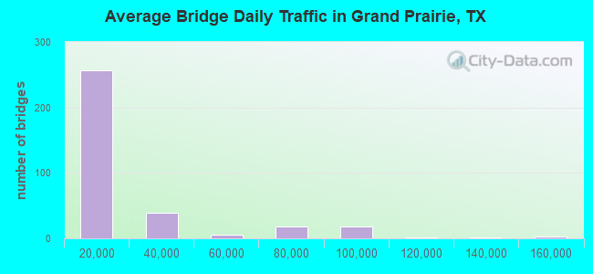
- 7,358,092Total average daily traffic
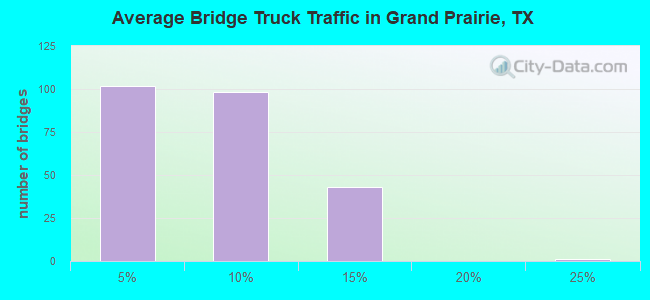
- 407,803Total average daily truck traffic
- National Bridge Inventory (NBI) Registered Bridges for Grand Prairie
- No street view available for this location
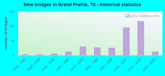
- New bridges - historical statistics
- 51930-1939
- 41940-1949
- 71950-1959
- 141960-1969
- 311970-1979
- 281980-1989
- 271990-1999
- 972000-2009
- 1192010-2019
- 142020-2022
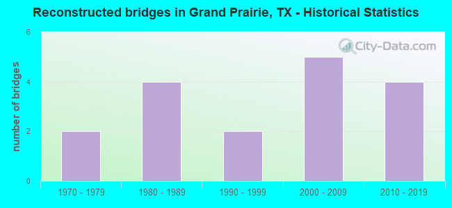
- Reconstructed bridges - Historical Statistics
- 21970-1979
- 41980-1989
- 21990-1999
- 52000-2009
- 42010-2019
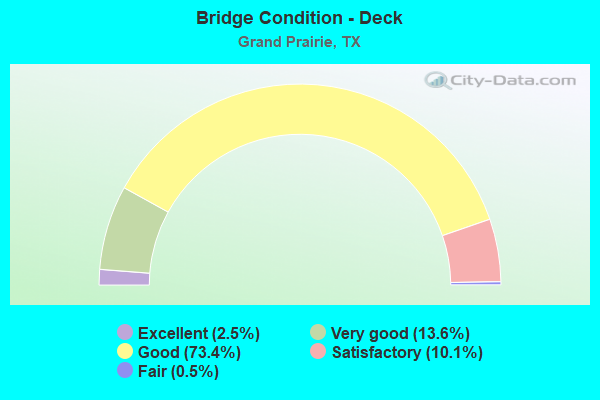
- Bridge Condition - Deck
- 2.5%Excellent
- 13.6%Very good
- 73.4%Good
- 10.1%Satisfactory
- 0.5%Fair
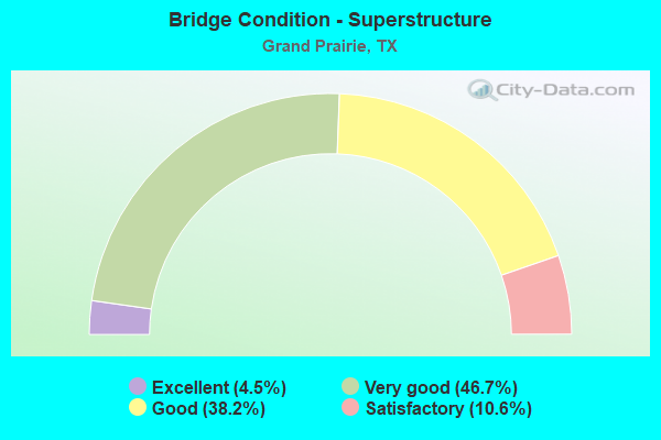
- Bridge Condition - Superstructure
- 4.5%Excellent
- 46.7%Very good
- 38.2%Good
- 10.6%Satisfactory
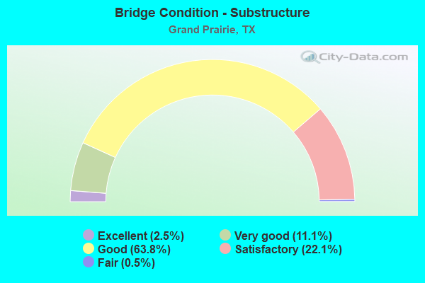
- Bridge Condition - Substructure
- 2.5%Excellent
- 11.1%Very good
- 63.8%Good
- 22.1%Satisfactory
- 0.5%Fair
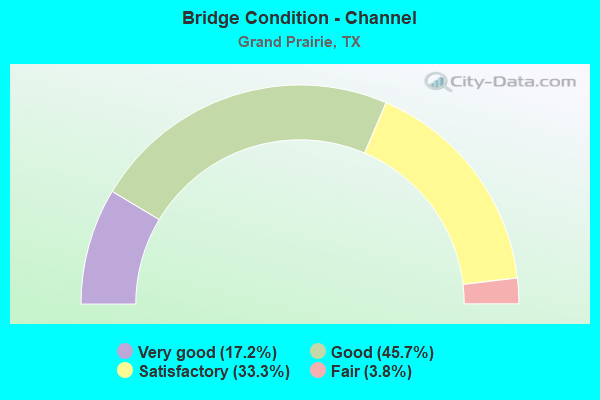
- Bridge Condition - Channel
- 17.2%Very good
- 45.7%Good
- 33.3%Satisfactory
- 3.8%Fair
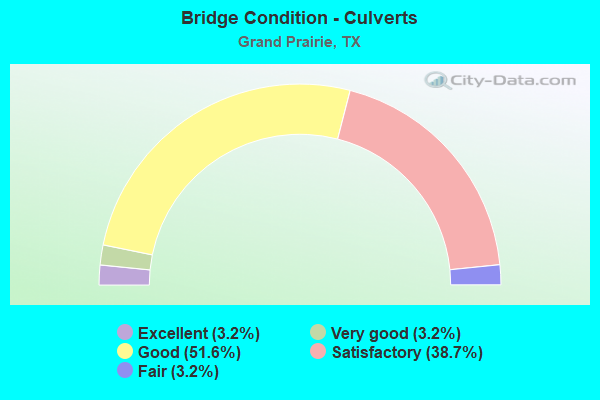
- Bridge Condition - Culverts
- 3.2%Excellent
- 3.2%Very good
- 51.6%Good
- 38.7%Satisfactory
- 3.2%Fair
Find on map >> Show street view
Structure Number: 180570296401481, Location: 2.28 MI S OF SH 183 (Lat: 32.803917, Lng: -97.018639), Route carried "under" structure: City street , Year Built: 2009, Structure Length: 0. m, Average Daily Traffic: 6,547 (year 2016), Truck Traffic: 13%, Features Intersected: TRINITY BLVD SHADY GR, Facility Carried by Structure: PGBT SBML
Minimum Vertical Clearance: 5.69m (18.67ft), Kilometerpoint: 0.000, Lanes on structure: 14, Material/Design: Prestressed concrete, Design/Construction: Stringer/Multi-beam, Length of Maximum Span: 37.8m (124.0ft)
Find on map >> Show street view
Structure Number: 180570296401482, Location: 2.28 MI S OF SH 183 (Lat: 32.798222, Lng: -97.018167), Route carried "under" structure: City street , Year Built: 2009, Structure Length: 0. m, Average Daily Traffic: 6,547 (year 2016), Truck Traffic: 13%, Features Intersected: TRINITY BLVD SHADY GR, Facility Carried by Structure: SH 161 NBML
Minimum Vertical Clearance: 6.07m (19.91ft), Kilometerpoint: 0.000, Lanes on structure: 14, Material/Design: Prestressed concrete, Design/Construction: Stringer/Multi-beam, Length of Maximum Span: 37.8m (124.0ft)
Find on map >> Show street view
Structure Number: 180570296401484, Location: 1.40 MI SOUTH OF SH 183 (Lat: 32.808528, Lng: -97.017972), Route carried "under" structure: City street , Year Built: 2009, Structure Length: 0. m, Average Daily Traffic: 5,839 (year 2016), Truck Traffic: 13%, Features Intersected: ROCK ISLAND RD BEAR CR, Facility Carried by Structure: SH 161 NB ML
Minimum Vertical Clearance: 5.89m (19.32ft), Kilometerpoint: 0.000, Lanes on structure: 9, Material/Design: Prestressed concrete, Design/Construction: Stringer/Multi-beam, Length of Maximum Span: 46.6m (152.9ft)
Find on map >> Show street view
Structure Number: 180570296401495, Location: IH20 / SH161 INTERCHANGE (Lat: 32.675575, Lng: -96.027936), Route carried "under" structure: Interstate 20, Year Built: 2012, Structure Length: 0. m, Average Daily Traffic: 22,300 (year 2013), Truck Traffic: 5%, Features Intersected: IH 20 SH 161 FISH CRK
Minimum Vertical Clearance: 6.71m (22.01ft), Kilometerpoint: 4.828, Lanes on structure: 29, Material/Design: Steel continuous, Design/Construction: Stringer/Multi-beam, Length of Maximum Span: 85.6m (280.8ft)
Find on map >> Show street view
Structure Number: 180570296401496, Location: IH20 / SH161 INTERCHANGE (Lat: 32.677261, Lng: -97.025058), Route carried "under" structure: ServiceInterstate 20, Year Built: 2012, Structure Length: 0. m, Average Daily Traffic: 15,000 (year 2015), Truck Traffic: 5%, Features Intersected: IH 20 WBFR & SH 161 SBFR
Minimum Vertical Clearance: 5.03m (16.50ft), Kilometerpoint: 3.291, Lanes on structure: 6, Material/Design: Prestressed concrete, Design/Construction: Stringer/Multi-beam, Length of Maximum Span: 41.1m (134.8ft)
Find on map >> Show street view
Structure Number: 180570296401497, Location: IH20 SH161 INTERCHANGE (Lat: 32.682075, Lng: -97.024425), Route carried "under" structure: Interstate 20, Year Built: 2012, Structure Length: 0. m, Average Daily Traffic: 15,000 (year 2015), Truck Traffic: 1%, Features Intersected: IH 20 SH 161 FISH CRK
Minimum Vertical Clearance: 6.10m (20.01ft), Kilometerpoint: 0.000, Lanes on structure: 25, Material/Design: Steel continuous, Design/Construction: Stringer/Multi-beam, Length of Maximum Span: 75.6m (248.0ft)
Find on map >> Show street view
Structure Number: 180570296401498, Location: IH20 / SH161 INTERCHANGE (Lat: 32.676383, Lng: -97.019897), Route carried "under" structure: ServiceInterstate 20, Year Built: 2012, Structure Length: 0. m, Average Daily Traffic: 15,000 (year 2015), Truck Traffic: 1%, Features Intersected: IH 20 WBFR & SH 161 NBFR
Minimum Vertical Clearance: 5.31m (17.42ft), Kilometerpoint: 0.000, Lanes on structure: 6, Material/Design: Prestressed concrete, Design/Construction: Stringer/Multi-beam, Length of Maximum Span: 41.5m (136.2ft)
Find on map >> Show street view
Structure Number: 180570296401499, Location: DC RAMP B20 ROBINSON RD (Lat: 32.675581, Lng: -97.016250), Route carried "under" structure: Other road , Year Built: 2019, Structure Length: 0. m, Average Daily Traffic: 5,040 (year 2017), Truck Traffic: 1%, Features Intersected: Robinson Rd, Facility Carried by Structure: SH 161 SB OFF-RAMP
Minimum Vertical Clearance: 5.12m (16.80ft), Kilometerpoint: 0.000, Lanes on structure: 1, Lanes under structure: 4, Toll: On toll road, Material/Design: Prestressed concrete, Design/Construction: Stringer/Multi-beam, Length of Maximum Span: 36.9m (121.1ft)
Find on map >> Show street view
Structure Number: 180570296401501, Location: 2.88 MI S OF IH 30 (Lat: 32.721383, Lng: -97.022758), Route carried "under" structure: City street , Year Built: 2012, Structure Length: 0. m, Average Daily Traffic: 500 (year 2016), Truck Traffic: 1%, Features Intersected: W MARSHALL DR, Facility Carried by Structure: PGBT SB
Minimum Vertical Clearance: 5.18m (16.99ft), Kilometerpoint: 1.239, Lanes on structure: 6, Material/Design: Prestressed concrete, Design/Construction: Stringer/Multi-beam, Length of Maximum Span: 30.5m (100.1ft)
Find on map >> Show street view
Structure Number: 180570296401502, Location: 2.88 MI S OF IH 30 (Lat: 32.720875, Lng: -97.022528), Route carried "under" structure: City street , Year Built: 2012, Structure Length: 0. m, Average Daily Traffic: 500 (year 2016), Truck Traffic: 1%, Features Intersected: W MARSHALL DR, Facility Carried by Structure: PGBT NB
Minimum Vertical Clearance: 6.00m (19.69ft), Kilometerpoint: 1.304, Lanes on structure: 6, Material/Design: Prestressed concrete, Design/Construction: Stringer/Multi-beam, Length of Maximum Span: 30.5m (100.1ft)
Find on map >> Show street view
Structure Number: 180570296401503, Location: 2.30 MI S OF IH 30 (Lat: 32.729233, Lng: -97.019683), Route carried "under" structure: City street , Year Built: 2012, Structure Length: 0. m, Average Daily Traffic: 1,000 (year 2016), Truck Traffic: 1%, Features Intersected: SW 14TH & COTTONWOOD CR, Facility Carried by Structure: PGBT SB
Minimum Vertical Clearance: 5.72m (18.77ft), Kilometerpoint: 1.400, Lanes on structure: 4, Material/Design: Prestressed concrete, Design/Construction: Stringer/Multi-beam, Length of Maximum Span: 40.8m (133.9ft)
Find on map >> Show street view
Structure Number: 180570296401504, Location: 2.30 MI S OF IH 30 (Lat: 32.727292, Lng: -97.019956), Route carried "under" structure: City street , Year Built: 2012, Structure Length: 0. m, Average Daily Traffic: 1,000 (year 2016), Truck Traffic: 1%, Features Intersected: SW 14TH & COTTONWOOD CR, Facility Carried by Structure: PGBT NB
Minimum Vertical Clearance: 6.25m (20.51ft), Kilometerpoint: 1.448, Lanes on structure: 4, Material/Design: Prestressed concrete, Design/Construction: Stringer/Multi-beam, Length of Maximum Span: 40.8m (133.9ft)
Find on map >> Show street view
Structure Number: 180570296401505, Location: 1.47 MI S OF IH 30 (Lat: 32.740767, Lng: -97.020250), Route carried "under" structure: Other road 161, Year Built: 2012, Structure Length: 0. m, Average Daily Traffic: 8,500 (year 2016), Truck Traffic: 5%, Features Intersected: SH 161, Facility Carried by Structure: W JEFFERSON ST
Minimum Vertical Clearance: 6.22m (20.41ft), Kilometerpoint: 48.377, Lanes on structure: 4, Toll: On toll road, Material/Design: Prestressed concrete, Design/Construction: Stringer/Multi-beam, Length of Maximum Span: 22.9m (75.1ft)
Find on map >> Show street view
Structure Number: 180570296401506, Location: 1.41 MI S OF IH 30 (Lat: 32.741983, Lng: -97.019967), Route carried "under" structure: Other road 161, Year Built: 2012, Structure Length: 0. m, Average Daily Traffic: 8,500 (year 2016), Truck Traffic: 5%, Features Intersected: SH 161, Facility Carried by Structure: W MAIN ST
Minimum Vertical Clearance: 8.23m (27.00ft), Kilometerpoint: 48.296, Lanes on structure: 4, Toll: On toll road, Material/Design: Prestressed concrete, Design/Construction: Stringer/Multi-beam, Length of Maximum Span: 23.5m (77.1ft)
Find on map >> Show street view
Structure Number: 180570296401507, Location: 1.20 MI S OF IH 30 (Lat: 32.744533, Lng: -97.021850), Route carried "under" structure: Other road 161, Year Built: 2012, Structure Length: 0. m, Average Daily Traffic: 6,500 (year 2016), Truck Traffic: 5%, Features Intersected: SH 161, Facility Carried by Structure: DALWORTH ST
Minimum Vertical Clearance: 5.79m (19.00ft), Kilometerpoint: 47.958, Lanes on structure: 4, Toll: On toll road, Material/Design: Prestressed concrete, Design/Construction: Stringer/Multi-beam, Length of Maximum Span: 28.0m (91.9ft)
Find on map >> Show street view
Structure Number: 180570296401508, Location: 0.55 MI S OF IH 30 (Lat: 32.751497, Lng: -97.028986), Route carried "under" structure: City street , Year Built: 2012, Structure Length: 0. m, Average Daily Traffic: 1,000 (year 2016), Truck Traffic: 1%, Features Intersected: JANUARY LN & DALWORTH CR, Facility Carried by Structure: PGBT SBML
Minimum Vertical Clearance: 7.06m (23.16ft), Kilometerpoint: 0.660, Lanes on structure: 4, Material/Design: Prestressed concrete, Design/Construction: Stringer/Multi-beam, Length of Maximum Span: 42.1m (138.1ft)
Find on map >> Show street view
Structure Number: 180570296401509, Location: 0.55 MI S OF IH 30 (Lat: 32.749833, Lng: -97.027547), Route carried "under" structure: City street , Year Built: 2012, Structure Length: 0. m, Average Daily Traffic: 1,000 (year 2016), Truck Traffic: 1%, Features Intersected: JANUARY LN & DALWORTH CR, Facility Carried by Structure: PGBT NBML
Minimum Vertical Clearance: 7.54m (24.74ft), Kilometerpoint: 0.692, Lanes on structure: 4, Material/Design: Prestressed concrete, Design/Construction: Stringer/Multi-beam, Length of Maximum Span: 43.0m (141.1ft)
Find on map >> Show street view
Structure Number: 18057029640151, Location: 0.16 MI S OF IH 30 (Lat: 32.756900, Lng: -97.029450), Route carried "under" structure: Other road 161, Year Built: 2012, Structure Length: 0. m, Average Daily Traffic: 71,000 (year 2016), Truck Traffic: 5%, Features Intersected: SH 161, Facility Carried by Structure: W TARRANT RD
Minimum Vertical Clearance: 6.40m (21.00ft), Kilometerpoint: 46.413, Lanes on structure: 5, Toll: On toll road, Material/Design: Prestressed concrete, Design/Construction: Stringer/Multi-beam, Length of Maximum Span: 29.9m (98.1ft)
Find on map >> Show street view
Structure Number: 180570296401511, Location: IH 30 & SH 161 I/C (Lat: 32.756711, Lng: -97.028614), Route carried "under" structure: Interstate 30, Year Built: 2013, Structure Length: 0. m, Average Daily Traffic: 15,000 (year 2016), Truck Traffic: 1%, Features Intersected: IH 30 & SH 161 I/C, Facility Carried by Structure: PGBT NB CONN G
Minimum Vertical Clearance: 17.37m (56.99ft), Kilometerpoint: 0.563, Lanes on structure: 22, Material/Design: Steel continuous, Design/Construction: Stringer/Multi-beam, Length of Maximum Span: 70.7m (232.0ft)
Find on map >> Show street view
Structure Number: 180570296401512, Location: IH 30 & SH 161 I/C (Lat: 32.758167, Lng: -97.028567), Route carried "under" structure: ServiceState highway 161, Year Built: 2012, Structure Length: 0. m, Average Daily Traffic: 6,000 (year 2016), Truck Traffic: 1%, Features Intersected: SH 161 NBFR & IH 30 EBFR
Minimum Vertical Clearance: 13.72m (45.01ft), Kilometerpoint: 46.253, Lanes on structure: 3, Material/Design: Prestressed concrete, Design/Construction: Stringer/Multi-beam, Length of Maximum Span: 28.0m (91.9ft)
Find on map >> Show street view
Structure Number: 180570296401521, Location: IH 30 & SH 161 I/C (Lat: 32.760767, Lng: -97.030058), Route carried "under" structure: Other road 161, Year Built: 2012, Structure Length: 0. m, Average Daily Traffic: 6,500 (year 2016), Features Intersected: SH 161 SB CONN F
Minimum Vertical Clearance: 10.21m (33.50ft), Kilometerpoint: 46.043, Lanes on structure: 1, Toll: On toll road, Material/Design: Prestressed concrete, Design/Construction: Stringer/Multi-beam, Length of Maximum Span: 30.5m (100.1ft)
Find on map >> Show street view
Structure Number: 180570296401523, Location: 1.00 MI N OF IH 20 (Lat: 32.692047, Lng: -97.024644), Route carried "under" structure: City street , Year Built: 2012, Structure Length: 0. m, Average Daily Traffic: 3,994 (year 2015), Truck Traffic: 2%, Features Intersected: MAYFIELD RD, Facility Carried by Structure: PGBT SB
Minimum Vertical Clearance: 5.26m (17.26ft), Kilometerpoint: 0.000, Lanes on structure: 8, Material/Design: Prestressed concrete, Design/Construction: Stringer/Multi-beam, Length of Maximum Span: 33.2m (108.9ft)
Find on map >> Show street view
Structure Number: 180570296401524, Location: 1.00 MI N OF IH 20 (Lat: 32.691464, Lng: -97.024144), Route carried "under" structure: City street , Year Built: 2012, Structure Length: 0. m, Average Daily Traffic: 3,994 (year 2015), Truck Traffic: 2%, Features Intersected: MAYFIELD RD, Facility Carried by Structure: PGBT NB
Minimum Vertical Clearance: 5.77m (18.93ft), Kilometerpoint: 0.000, Lanes on structure: 8, Material/Design: Prestressed concrete, Design/Construction: Stringer/Multi-beam, Length of Maximum Span: 33.2m (108.9ft)
Find on map >> Show street view
Structure Number: 180570296401528, Location: 1.52 MI N OF IH 20 (Lat: 32.698797, Lng: -97.024908), Route carried "under" structure: City street , Year Built: 2012, Structure Length: 0. m, Average Daily Traffic: 6,589 (year 2015), Truck Traffic: 2%, Features Intersected: WARRIOR TRAIL, Facility Carried by Structure: PGBT SB
Minimum Vertical Clearance: 5.21m (17.09ft), Kilometerpoint: 0.000, Lanes on structure: 8, Material/Design: Prestressed concrete, Design/Construction: Stringer/Multi-beam, Length of Maximum Span: 29.0m (95.1ft)
Find on map >> Show street view
Structure Number: 180570296401529, Location: 1.52 MI N OF IH 20 (Lat: 32.698281, Lng: -97.024353), Route carried "under" structure: City street , Year Built: 2012, Structure Length: 0. m, Average Daily Traffic: 6,589 (year 2015), Truck Traffic: 2%, Features Intersected: WARRIOR TRAIL, Facility Carried by Structure: PGBT NB
Minimum Vertical Clearance: 5.72m (18.77ft), Kilometerpoint: 0.000, Lanes on structure: 8, Material/Design: Prestressed concrete, Design/Construction: Stringer/Multi-beam, Length of Maximum Span: 29.0m (95.1ft)
Find on map >> Show street view
Structure Number: 18057029640153, Location: 2.00 MI N OF IH 20 (Lat: 32.705708, Lng: -97.024944), Route carried "under" structure: City street , Year Built: 2012, Structure Length: 0. m, Average Daily Traffic: 3,170 (year 2015), Truck Traffic: 2%, Features Intersected: ARKANSAS LANE, Facility Carried by Structure: PGBT SB
Minimum Vertical Clearance: 6.40m (21.00ft), Kilometerpoint: 0.000, Lanes on structure: 8, Material/Design: Prestressed concrete, Design/Construction: Stringer/Multi-beam, Length of Maximum Span: 30.8m (101.0ft)
Find on map >> Show street view
Structure Number: 180570296401531, Location: 2.00 MI N OF IH 20 (Lat: 32.705142, Lng: -97.024444), Route carried "under" structure: City street , Year Built: 2012, Structure Length: 0. m, Average Daily Traffic: 3,170 (year 2015), Truck Traffic: 2%, Features Intersected: ARKANSAS LANE, Facility Carried by Structure: PGBT NB
Minimum Vertical Clearance: 5.87m (19.26ft), Kilometerpoint: 0.000, Lanes on structure: 8, Material/Design: Prestressed concrete, Design/Construction: Stringer/Multi-beam, Length of Maximum Span: 30.8m (101.0ft)
Find on map >> Show street view
Structure Number: 180570296401532, Location: 2.35 MI N OF IH 20 (Lat: 32.710197, Lng: -97.024972), Route carried "under" structure: State highway 303, Year Built: 2012, Structure Length: 0. m, Average Daily Traffic: 25,397 (year 2015), Truck Traffic: 5%, Features Intersected: SPUR 303 / PIONEER PKWY, Facility Carried by Structure: PGBT SB
Minimum Vertical Clearance: 6.43m (21.10ft), Kilometerpoint: 0.000, Lanes on structure: 11, Material/Design: Prestressed concrete, Design/Construction: Stringer/Multi-beam, Length of Maximum Span: 38.1m (125.0ft)
Find on map >> Show street view
Structure Number: 180570296401533, Location: 2.35 MI N OF IH 20 (Lat: 32.709492, Lng: -97.024458), Route carried "under" structure: State highway 303, Year Built: 2012, Structure Length: 0. m, Average Daily Traffic: 25,397 (year 2015), Truck Traffic: 5%, Features Intersected: SPUR 303 / PIONEER PKWY, Facility Carried by Structure: PGBT NB
Minimum Vertical Clearance: 6.30m (20.67ft), Kilometerpoint: 0.000, Lanes on structure: 12, Material/Design: Prestressed concrete, Design/Construction: Stringer/Multi-beam, Length of Maximum Span: 38.1m (125.0ft)
Find on map >> Show street view
Structure Number: 180570296401622, Location: 0.37 MI N OF IH 30 (Lat: 32.764817, Lng: -97.028656), Route carried "under" structure: State highway 161, Year Built: 2009, Structure Length: 0. m, Average Daily Traffic: 71,090 (year 2011), Truck Traffic: 12%, Features Intersected: SH 161, Facility Carried by Structure: EGYPTIAN WAY WB
Minimum Vertical Clearance: 7.62m (25.00ft), Kilometerpoint: 45.565, Lanes on structure: 7, Material/Design: Prestressed concrete, Design/Construction: Stringer/Multi-beam, Length of Maximum Span: 32.0m (105.0ft)