Bridge Statistics for Grand Rapids, Michigan (MI)
Condition, Traffic, Stress, Structural Evaluation, Project Costs
- National Bridge Inventory (NBI) Statistics
- 269Number of bridges
- 4,331ft / 1,320mTotal length
- $3,922,000Total costs
- 6,381,085Total average daily traffic
- 408,489Total average daily truck traffic
- National Bridge Inventory (NBI) Registered Bridges for Grand Rapids
- No street view available for this location
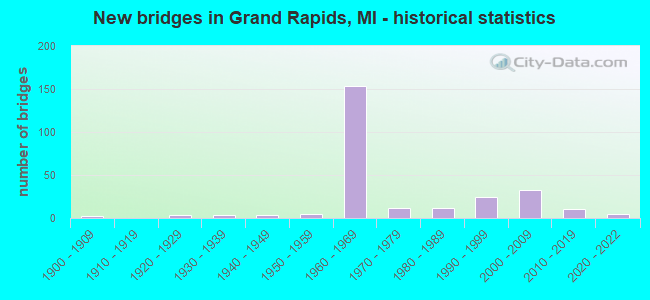
- New bridges - historical statistics
- 1Before 1900
- 21900-1909
- 41920-1929
- 31930-1939
- 41940-1949
- 51950-1959
- 1531960-1969
- 121970-1979
- 121980-1989
- 251990-1999
- 332000-2009
- 102010-2019
- 52020-2022
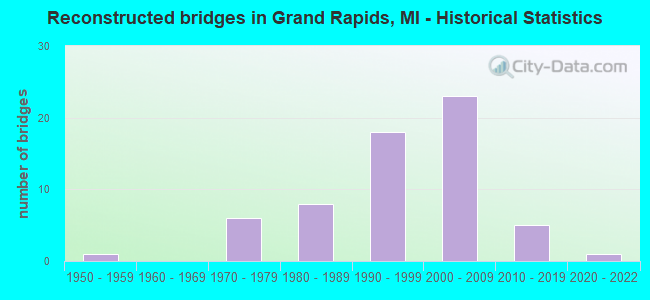
- Reconstructed bridges - Historical Statistics
- 11950-1959
- 01960-1969
- 61970-1979
- 81980-1989
- 181990-1999
- 232000-2009
- 52010-2019
- 12020-2022
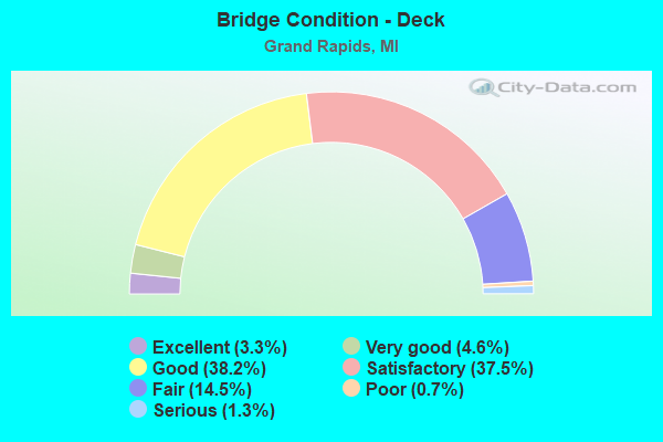
- Bridge Condition - Deck
- 3.3%Excellent
- 4.6%Very good
- 38.2%Good
- 37.5%Satisfactory
- 14.5%Fair
- 0.7%Poor
- 1.3%Serious
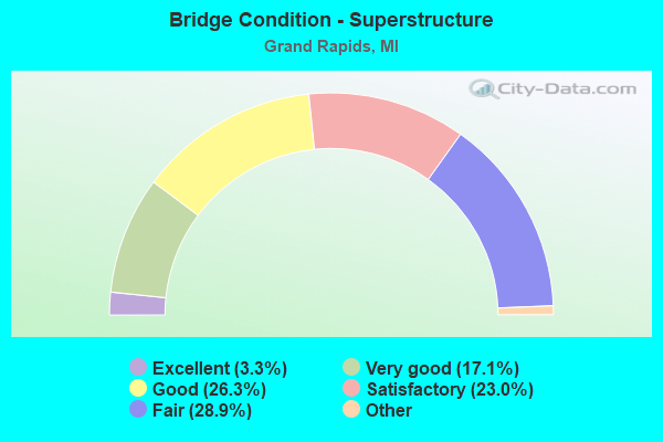
- Bridge Condition - Superstructure
- 3.3%Excellent
- 17.1%Very good
- 26.3%Good
- 23.0%Satisfactory
- 28.9%Fair
- 1.3%Poor
- 0.7%Serious
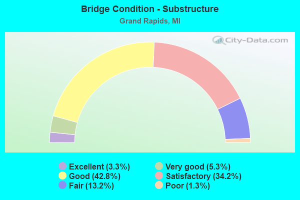
- Bridge Condition - Substructure
- 3.3%Excellent
- 5.3%Very good
- 42.8%Good
- 34.2%Satisfactory
- 13.2%Fair
- 1.3%Poor
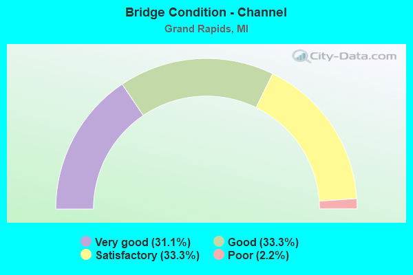
- Bridge Condition - Channel
- 31.1%Very good
- 33.3%Good
- 33.3%Satisfactory
- 2.2%Poor
Find on map >> Show street view
Structure Number: 52, Location: 3.4 MI E OF SHINGLETON (Lat: 46.346908, Lng: -86.400872), Route carried "on" structure: State highway 28, Year Built: 1947, Status: Open, Structure Length: 1.52m (4.99ft), Average Daily Traffic: 1,973 (year 2007), Truck Traffic: 13%, Average Future Daily Traffic: 3,096 (year 2018), Design Load: HS 20, Features Intersected: STAR CREEK
Minimum Vertical Clearance: 30.48m (100.00ft), Kilometerpoint: 22.231, Lanes on structure: 2, Base Highway Network: Yes (Inventory Route: 113, Subroute: 6), Owner: State Highway Agency, Approaching Roadway Width: 12.2m (40.0ft), Material/Design: Steel, Design/Construction: Stringer/Multi-beam, Number Of Spans In Main Unit: 1, Length of Maximum Span: 15.2m (49.9ft), Curb or Sidewalk Widths: Left: 0.4m (1.3ft), Right: 0.4m (1.3ft), Curb-To-Curb Width: 11.6m (38.1ft), Out-to-Out Width: 13.3m (43.6ft)
Condition: Deck: Fair, Superstructure: Satisfactory, Substructure: Good, Channel: Satisfactory, Operating Rating: 60.6 metric tons, Method Used To Determine Operating Rating: Load Factor (LF) rating reported by rating factor (RF) method using MS18 loading, Inventory Rating: 36.3 metric tons, Method Used To Determine Inventory Rating: Load Factor (LF) rating reported by rating factor (RF) method using MS18 loading, Structural Evaluation: Equal to present minimum criteria, Deck Geometry: Equal to present minimum criteria, Waterway Adequacy: Better than present minimum criteria, Approach Roadway Alignment: Equal to present desirable criteria, Designated Inspection Frequency: Every 24 months, Inspection Date: May 2021, Deck Structure Type: Concrete Cast-file-Place, Wearing Surface/Protective System: Wearing Surface: Bituminous
Find on map >> Show street view
Structure Number: 478, Location: 0.4 MI W OF US-23 (Lat: 44.143611, Lng: -83.575647), Route carried "on" structure: County highway , Year Built: 2000, Status: Open, Structure Length: 1.43m (4.69ft), Average Daily Traffic: 130 (year 1998), Average Future Daily Traffic: 70 (year 1977), Design Load: HS 20, Features Intersected: WHITNEY DRAIN, Facility Carried by Structure: NOBLE ROAD
Minimum Vertical Clearance: 30.48m (100.00ft), Kilometerpoint: 3.227, Lanes on structure: 2, Owner: County Highway Agency, Approaching Roadway Width: 6.1m (20.0ft), Material/Design: Prestressed concrete, Design/Construction: Box Beam or Girders - Multiple, Number Of Spans In Main Unit: 1, Length of Maximum Span: 14.0m (45.9ft), Curb-To-Curb Width: 4.9m (16.1ft), Out-to-Out Width: 9.3m (30.5ft)
Condition: Deck: Satisfactory, Superstructure: Very good, Substructure: Very good, Channel: Satisfactory, Operating Rating: 97.2 metric tons, Method Used To Determine Operating Rating: Load Factor (LF) rating reported by rating factor (RF) method using MS18 loading, Inventory Rating: 48.6 metric tons, Method Used To Determine Inventory Rating: Load Factor (LF) rating reported by rating factor (RF) method using MS18 loading, Structural Evaluation: Equal to present desirable criteria, Deck Geometry: High priority of replacement, Waterway Adequacy: Better than present minimum criteria, Approach Roadway Alignment: Better than present minimum criteria, Length Of Structure Improvement: 2.04m (6.69ft), Designated Inspection Frequency: Every 24 months, Inspection Date: August 2020, Bridge Improvement Cost: $183,000, Roadway Improvement Cost: $18,000, Total Project Cost: $215,000, Deck Structure Type: Concrete Cast-file-Place, Wearing Surface/Protective System: Wearing Surface: Monolithic Concrete, Deck Protection: Epoxy Coated Reinforcing
Find on map >> Show street view
Structure Number: 479, Location: CITY OF STANDISH (Lat: 43.988022, Lng: -83.957022), Route carried "on" structure: City street , Year Built: 1989, Status: Open, Structure Length: 1.46m (4.79ft), Average Daily Traffic: 1,000 (year 2004), Truck Traffic: 7%, Average Future Daily Traffic: 2,500 (year 2024), Design Load: HS 20, Features Intersected: MIDDLE BR PINE RIVER, Facility Carried by Structure: GROVE STREET
Minimum Vertical Clearance: 30.48m (100.00ft), Kilometerpoint: 1.077, Lanes on structure: 2, Owner: City or Municipal Highway Agency, Approaching Roadway Width: 5.5m (18.0ft), Skew: 2 degrees, Material/Design: Prestressed concrete, Design/Construction: Box Beam or Girders - Multiple, Number Of Spans In Main Unit: 1, Length of Maximum Span: 14.0m (45.9ft), Curb or Sidewalk Widths: Left: 1.5m (4.9ft), Right: 1.5m (4.9ft), Curb-To-Curb Width: 7.9m (25.9ft), Out-to-Out Width: 11.6m (38.1ft)
Condition: Deck: Satisfactory, Superstructure: Satisfactory, Substructure: Good, Channel: Good, Operating Rating: 52.5 metric tons, Method Used To Determine Operating Rating: Load and Resistance Factor Rating (LRFR) rating reported by rating factor(RF) method using HL-93 loadings, Inventory Rating: 42.1 metric tons, Method Used To Determine Inventory Rating: Load and Resistance Factor Rating (LRFR) rating reported by rating factor(RF) method using HL-93 loadings, Structural Evaluation: Equal to present minimum criteria, Deck Geometry: Somewhat better than minimum adequacy, Waterway Adequacy: Better than present minimum criteria, Approach Roadway Alignment: Equal to present minimum criteria, Designated Inspection Frequency: Every 12 months, Inspection Date: October 2021, Deck Structure Type: Other, Wearing Surface/Protective System: Wearing Surface: Bituminous, Membrane: Epoxy, Deck Protection: Epoxy Coated Reinforcing
Find on map >> Show street view
Structure Number: 481, Location: 6.5 MI W OF NESTORIA (Lat: 46.578839, Lng: -88.412819), Route carried "on" structure: US 41, Year Built: 1947, Status: Open, Structure Length: 0.91m (2.99ft), Average Daily Traffic: 2,624 (year 2007), Truck Traffic: 11%, Average Future Daily Traffic: 4,613 (year 2018), Design Load: HS 20, Features Intersected: HICKEY CREEK
Minimum Vertical Clearance: 30.48m (100.00ft), Kilometerpoint: 23.763, Lanes on structure: 2, Base Highway Network: Yes (Inventory Route: 118, Subroute: 7), Owner: State Highway Agency, Approaching Roadway Width: 11.6m (38.1ft), Skew: 1 degrees, Material/Design: Concrete, Design/Construction: Tee Beam, Number Of Spans In Main Unit: 1, Length of Maximum Span: 9.1m (29.9ft), Curb-To-Curb Width: 11.6m (38.1ft), Out-to-Out Width: 19.3m (63.3ft)
Condition: Deck: Good, Superstructure: Very good, Substructure: Good, Channel: Good, Operating Rating: 70.3 metric tons, Method Used To Determine Operating Rating: Load Factor (LF) rating reported by rating factor (RF) method using MS18 loading, Inventory Rating: 42.4 metric tons, Method Used To Determine Inventory Rating: Load Factor (LF) rating reported by rating factor (RF) method using MS18 loading, Structural Evaluation: Better than present minimum criteria, Deck Geometry: Somewhat better than minimum adequacy, Waterway Adequacy: Equal to present desirable criteria, Approach Roadway Alignment: Equal to present minimum criteria, Designated Inspection Frequency: Every 24 months, Inspection Date: July 2021, Deck Structure Type: Concrete Cast-file-Place, Wearing Surface/Protective System: Wearing Surface: Bituminous
Find on map >> Show street view
Structure Number: 482, Location: 1.4 MI S OF ALBERTA (Lat: 46.625164, Lng: -88.470222), Route carried "on" structure: US 41, Year Built: 1947, Year Reconstructed: 1998, Status: Open, Structure Length: 7.07m (23.20ft), Average Daily Traffic: 3,585 (year 2007), Truck Traffic: 17%, Average Future Daily Traffic: 3,800 (year 2020), Design Load: HS 20, Features Intersected: STURGEON RIVER
Minimum Vertical Clearance: 30.48m (100.00ft), Kilometerpoint: 33.035, Lanes on structure: 2, Base Highway Network: Yes (Inventory Route: 118, Subroute: 7), Owner: State Highway Agency, Approaching Roadway Width: 12.2m (40.0ft), Material/Design: Steel, Design/Construction: Arch - Deck, Number Of Spans In Main Unit: 1, Number Of Approach Spans: 2, Length of Maximum Span: 39.0m (128.0ft), Curb-To-Curb Width: 12.8m (42.0ft), Out-to-Out Width: 13.8m (45.3ft)
Condition: Deck: Satisfactory, Superstructure: Fair, Substructure: Fair, Channel: Very good, Operating Rating: 59.0 metric tons, Method Used To Determine Operating Rating: Load Factor (LF) rating reported by rating factor (RF) method using MS18 loading, Inventory Rating: 35.3 metric tons, Method Used To Determine Inventory Rating: Load Factor (LF) rating reported by rating factor (RF) method using MS18 loading, Structural Evaluation: Somewhat better than minimum adequacy, Deck Geometry: Equal to present minimum criteria, Waterway Adequacy: Equal to present desirable criteria, Approach Roadway Alignment: Equal to present minimum criteria, Designated Inspection Frequency: Every 24 months, Inspection Date: May 2021, Deck Structure Type: Concrete Cast-file-Place, Wearing Surface/Protective System: Wearing Surface: Monolithic Concrete, Deck Protection: Epoxy Coated Reinforcing
Find on map >> Show street view
Structure Number: 483, Location: 4.0 MI S OF L'ANSE (Lat: 46.703442, Lng: -88.442303), Route carried "on" structure: US 41, Year Built: 1951, Status: Open, Structure Length: 1.22m (4.00ft), Average Daily Traffic: 3,585 (year 2007), Truck Traffic: 10%, Average Future Daily Traffic: 6,177 (year 2018), Design Load: HS 20, Features Intersected: TAYLOR CREEK
Minimum Vertical Clearance: 30.48m (100.00ft), Kilometerpoint: 42.491, Lanes on structure: 2, Base Highway Network: Yes (Inventory Route: 118, Subroute: 7), Owner: State Highway Agency, Approaching Roadway Width: 12.2m (40.0ft), Skew: 3 degrees, Material/Design: Steel, Design/Construction: Stringer/Multi-beam, Number Of Spans In Main Unit: 1, Length of Maximum Span: 12.2m (40.0ft), Curb or Sidewalk Widths: Left: 0.4m (1.3ft), Right: 0.4m (1.3ft), Curb-To-Curb Width: 11.6m (38.1ft), Out-to-Out Width: 13.2m (43.3ft)
Condition: Deck: Good, Superstructure: Good, Substructure: Good, Channel: Good, Operating Rating: 68.7 metric tons, Method Used To Determine Operating Rating: Load Factor (LF) rating reported by rating factor (RF) method using MS18 loading, Inventory Rating: 41.1 metric tons, Method Used To Determine Inventory Rating: Load Factor (LF) rating reported by rating factor (RF) method using MS18 loading, Structural Evaluation: Better than present minimum criteria, Deck Geometry: Somewhat better than minimum adequacy, Waterway Adequacy: Better than present minimum criteria, Approach Roadway Alignment: Equal to present minimum criteria, Length Of Structure Improvement: 1.22m (4.00ft), Designated Inspection Frequency: Every 24 months, Inspection Date: July 2021, Bridge Improvement Cost: $23,000, Deck Structure Type: Concrete Cast-file-Place, Wearing Surface/Protective System: Wearing Surface: Monolithic Concrete
Find on map >> Show street view
Structure Number: 495, Location: 3.5 MI W OF NESTORIA (Lat: 46.575417, Lng: -88.340717), Route carried "on" structure: US 41, Year Built: 1947, Status: Open, Structure Length: 1.09m (3.58ft), Average Daily Traffic: 2,624 (year 2007), Truck Traffic: 11%, Average Future Daily Traffic: 4,970 (year 2018), Design Load: HS 20, Features Intersected: TIOGA RIVER BURIED
Minimum Vertical Clearance: 30.48m (100.00ft), Kilometerpoint: 18.206, Lanes on structure: 2, Base Highway Network: Yes (Inventory Route: 118, Subroute: 7), Owner: State Highway Agency, Approaching Roadway Width: 12.2m (40.0ft), Material/Design: Concrete, Design/Construction: Tee Beam, Number Of Spans In Main Unit: 1, Length of Maximum Span: 10.9m (35.8ft), Curb-To-Curb Width: 11.6m (38.1ft), Out-to-Out Width: 20.2m (66.3ft)
Condition: Deck: Good, Superstructure: Good, Substructure: Good, Channel: Very good, Operating Rating: 70.0 metric tons, Method Used To Determine Operating Rating: Load Factor (LF) rating reported by rating factor (RF) method using MS18 loading, Inventory Rating: 41.8 metric tons, Method Used To Determine Inventory Rating: Load Factor (LF) rating reported by rating factor (RF) method using MS18 loading, Structural Evaluation: Better than present minimum criteria, Deck Geometry: Somewhat better than minimum adequacy, Waterway Adequacy: Equal to present desirable criteria, Approach Roadway Alignment: Better than present minimum criteria, Designated Inspection Frequency: Every 24 months, Inspection Date: July 2021, Deck Structure Type: Concrete Cast-file-Place, Wearing Surface/Protective System: Wearing Surface: Bituminous
Find on map >> Show street view
Structure Number: 519, Location: 6 MI NE OF COVINGTON (Lat: 46.570903, Lng: -88.407642), Route carried "on" structure: County highway , Year Built: 2020, Status: Open, Structure Length: 1.41m (4.63ft), Average Daily Traffic: 68 (year 2020), Truck Traffic: 8%, Average Future Daily Traffic: 108 (year 2040), Design Load: Greater than HL93, Features Intersected: HICKEY CREEK, Facility Carried by Structure: OLD M-28
Minimum Vertical Clearance: 30.48m (100.00ft), Kilometerpoint: 9.875, Lanes on structure: 2, Owner: County Highway Agency, Approaching Roadway Width: 9.1m (29.9ft), Skew: 2 degrees, Material/Design: Prestressed concrete, Design/Construction: Stringer/Multi-beam, Number Of Spans In Main Unit: 1, Length of Maximum Span: 12.2m (40.0ft), Curb-To-Curb Width: 9.1m (29.9ft), Out-to-Out Width: 10.1m (33.1ft)
Condition: Deck: Excellent, Superstructure: Excellent, Substructure: Excellent, Channel: Very good, Operating Rating: 61.9 metric tons, Method Used To Determine Operating Rating: Load and Resistance Factor Rating (LRFR) rating reported by rating factor(RF) method using HL-93 loadings, Inventory Rating: 47.6 metric tons, Method Used To Determine Inventory Rating: Load and Resistance Factor Rating (LRFR) rating reported by rating factor(RF) method using HL-93 loadings, Structural Evaluation: Superior to present desirable criteria, Deck Geometry: Better than present minimum criteria, Waterway Adequacy: Better than present minimum criteria, Approach Roadway Alignment: Better than present minimum criteria, Length Of Structure Improvement: 1.98m (6.50ft), Designated Inspection Frequency: Every 24 months, Inspection Date: September 2021, Bridge Improvement Cost: $550,000, Roadway Improvement Cost: $100,000, Total Project Cost: $675,000 ( Estimate for 2015), Deck Structure Type: Concrete Cast-file-Place, Wearing Surface/Protective System: Wearing Surface: Monolithic Concrete, Deck Protection: Epoxy Coated Reinforcing
Find on map >> Show street view
Structure Number: 521, Location: 0.25 MI S OF HERMAN (Lat: 46.663236, Lng: -88.365561), Route carried "on" structure: County highway , Year Built: 2006, Status: Open, Structure Length: 1.52m (4.99ft), Average Daily Traffic: 37 (year 2015), Truck Traffic: 3%, Average Future Daily Traffic: 100 (year 2035), Design Load: HS 20, Features Intersected: DAULTS CREEK, Facility Carried by Structure: HERMAN-NESTORIA RD
Minimum Vertical Clearance: 30+ m (98+ ft), Kilometerpoint: 14.213, Lanes on structure: 2, Owner: County Highway Agency, Approaching Roadway Width: 9.1m (29.9ft), Material/Design: Wood or Timber, Design/Construction: Slab, Number Of Spans In Main Unit: 3, Length of Maximum Span: 6.1m (20.0ft), Curb-To-Curb Width: 9.8m (32.2ft), Out-to-Out Width: 10.4m (34.1ft)
Condition: Deck: Very good, Superstructure: Very good, Substructure: Very good, Channel: Good, Operating Rating: 32.4 metric tons, Method Used To Determine Operating Rating: Load Factor (LF), Inventory Rating: 32.0 metric tons, Method Used To Determine Inventory Rating: Load Factor (LF), Structural Evaluation: Better than present minimum criteria, Waterway Adequacy: Equal to present minimum criteria, Approach Roadway Alignment: Equal to present minimum criteria, Designated Inspection Frequency: Every 24 months, Inspection Date: September 2021, Deck Structure Type: Wood or Timber, Wearing Surface/Protective System: Wearing Surface: Bituminous, Membrane: Preformed Fabric
Find on map >> Show street view
Structure Number: 1284, Location: 3.0 MI W OF JACKSON COL (Lat: 42.267611, Lng: -84.776042), Route carried "on" structure: County highway , Year Built: 1960, Status: Open, Structure Length: 10.97m (35.99ft), Average Daily Traffic: 900 (year 1988), Truck Traffic: 3%, Average Future Daily Traffic: 1,225 (year 2000), Design Load: H 15, Features Intersected: I-94, Facility Carried by Structure: 27 MILE ROAD
Minimum Vertical Clearance: 30.48m (100.00ft), Kilometerpoint: 1.110, Lanes on structure: 2, Lanes under structure: 4, Owner: State Highway Agency, Approaching Roadway Width: 6.7m (22.0ft), Skew: 5 degrees, Material/Design: Concrete continuous, Design/Construction: Tee Beam, Number Of Spans In Main Unit: 4, Length of Maximum Span: 34.3m (112.5ft), Curb or Sidewalk Widths: Left: 0.2m (0.7ft), Right: 0.2m (0.7ft), Curb-To-Curb Width: 7.9m (25.9ft), Out-to-Out Width: 10.2m (33.5ft)
Condition: Deck: Fair, Superstructure: Fair, Substructure: Satisfactory, Operating Rating: 70.6 metric tons, Method Used To Determine Operating Rating: Load Factor (LF) rating reported by rating factor (RF) method using MS18 loading, Inventory Rating: 42.1 metric tons, Method Used To Determine Inventory Rating: Load Factor (LF) rating reported by rating factor (RF) method using MS18 loading, Structural Evaluation: Somewhat better than minimum adequacy, Deck Geometry: Somewhat better than minimum adequacy, Underclear: Meets minimum limits, Approach Roadway Alignment: Better than present minimum criteria, Designated Inspection Frequency: Every 24 months, Inspection Date: June 2021, Deck Structure Type: Concrete Cast-file-Place, Wearing Surface/Protective System: Wearing Surface: Latex Concrete
Find on map >> Show street view
Structure Number: 1394, Location: ONE BLK WEST OF M-99 (Lat: 42.245608, Lng: -84.754572), Route carried "on" structure: City street , Year Built: 2010, Status: Open, Structure Length: 2.01m (6.59ft), Average Daily Traffic: 5,775 (year 2009), Truck Traffic: 12%, Average Future Daily Traffic: 7,775 (year 2029), Design Load: HS 20+Mod, Features Intersected: KALAMAZOO RIVER, Facility Carried by Structure: N CLINTON STREET
Minimum Vertical Clearance: 30.48m (100.00ft), Kilometerpoint: 0.853, Lanes on structure: 2, Owner: City or Municipal Highway Agency, Approaching Roadway Width: 14.6m (47.9ft), Material/Design: Prestressed concrete, Design/Construction: Box Beam or Girders - Multiple, Number Of Spans In Main Unit: 1, Length of Maximum Span: 18.9m (62.0ft), Curb or Sidewalk Widths: Left: 2.0m (6.6ft), Right: 2.0m (6.6ft), Curb-To-Curb Width: 12.5m (41.0ft), Out-to-Out Width: 17.2m (56.4ft)
Condition: Deck: Satisfactory, Superstructure: Very good, Substructure: Good, Channel: Good, Operating Rating: 76.0 metric tons, Method Used To Determine Operating Rating: Load Factor (LF), Inventory Rating: 45.0 metric tons, Method Used To Determine Inventory Rating: Load Factor (LF), Structural Evaluation: Better than present minimum criteria, Deck Geometry: Somewhat better than minimum adequacy, Waterway Adequacy: Better than present minimum criteria, Approach Roadway Alignment: Equal to present desirable criteria, Length Of Structure Improvement: 2.59m (8.50ft), Designated Inspection Frequency: Every 24 months, Inspection Date: August 2020, Bridge Improvement Cost: $340,000, Roadway Improvement Cost: $50,000, Total Project Cost: $390,000, Deck Structure Type: Concrete Cast-file-Place, Wearing Surface/Protective System: Wearing Surface: Monolithic Concrete, Deck Protection: Epoxy Coated Reinforcing
Find on map >> Show street view
Structure Number: 4707, Location: IN GRAND RAPIDS (LEONARD (Lat: 42.984697, Lng: -85.671808), Route carried "on" structure: Business US 131, Year Built: 1979, Status: Open, Structure Length: 18.59m (60.99ft), Average Daily Traffic: 21,583 (year 2014), Truck Traffic: 2%, Average Future Daily Traffic: 24,820 (year 2034), Design Load: HS 25 or greater, Features Intersected: GRAND RIVER
Minimum Vertical Clearance: 30.48m (100.00ft), Kilometerpoint: 0.544, Lanes on structure: 4, Base Highway Network: Yes (Inventory Route: 40, Subroute: 10), Owner: State Highway Agency, Approaching Roadway Width: 15.8m (51.8ft), Material/Design: Steel, Design/Construction: Stringer/Multi-beam, Number Of Spans In Main Unit: 7, Length of Maximum Span: 28.9m (94.8ft), Curb or Sidewalk Widths: Left: 1.8m (5.9ft), Right: 1.8m (5.9ft), Curb-To-Curb Width: 15.8m (51.8ft), Out-to-Out Width: 20.1m (65.9ft)
Condition: Deck: Good, Superstructure: Satisfactory, Substructure: Fair, Channel: Good, Operating Rating: 68.0 metric tons, Method Used To Determine Operating Rating: Load Factor (LF) rating reported by rating factor (RF) method using MS18 loading, Inventory Rating: 40.8 metric tons, Method Used To Determine Inventory Rating: Load Factor (LF) rating reported by rating factor (RF) method using MS18 loading, Structural Evaluation: Somewhat better than minimum adequacy, Deck Geometry: Meets minimum limits, Waterway Adequacy: Equal to present desirable criteria, Approach Roadway Alignment: Equal to present desirable criteria, Designated Inspection Frequency: Every 24 months, Underwater Inspection Frequency: Every 60 months, Inspection Date: October 2020, Underwater Inspection Date: June 2020, Deck Structure Type: Concrete Cast-file-Place, Wearing Surface/Protective System: Wearing Surface: Latex Concrete, Deck Protection: Epoxy Coated Reinforcing
Find on map >> Show street view
Structure Number: 4708, Location: IN GRAND RAPIDS (Lat: 42.970447, Lng: -85.668625), Route carried "on" structure: City street 2001, Year Built: 2007, Status: Open, Structure Length: 2.58m (8.46ft), Truck Traffic: 3%, Average Future Daily Traffic: 54,000 (year 2027), Design Load: HS 25 or greater, Features Intersected: US-131 BR (DIVISION AVE), Facility Carried by Structure: MICHIGAN ST
Minimum Vertical Clearance: 30.48m (100.00ft), Kilometerpoint: 4.149, Lanes on structure: 4, Lanes under structure: 4, Owner: City or Municipal Highway Agency, Approaching Roadway Width: 21.3m (69.9ft), Skew: 1 degrees, Material/Design: Steel, Design/Construction: Stringer/Multi-beam, Number Of Spans In Main Unit: 1, Length of Maximum Span: 24.6m (80.7ft), Curb or Sidewalk Widths: Left: 3.4m (11.2ft), Right: 3.4m (11.2ft), Curb-To-Curb Width: 21.3m (69.9ft), Out-to-Out Width: 28.8m (94.5ft)
Condition: Deck: Good, Superstructure: Good, Substructure: Good, Operating Rating: 97.2 metric tons, Method Used To Determine Operating Rating: Load Factor (LF) rating reported by rating factor (RF) method using MS18 loading, Inventory Rating: 67.7 metric tons, Method Used To Determine Inventory Rating: Load Factor (LF) rating reported by rating factor (RF) method using MS18 loading, Structural Evaluation: Better than present minimum criteria, Deck Geometry: Superior to present desirable criteria, Underclear: Somewhat better than minimum adequacy, Approach Roadway Alignment: Equal to present desirable criteria, Designated Inspection Frequency: Every 24 months, Inspection Date: August 2021, Deck Structure Type: Concrete Cast-file-Place, Wearing Surface/Protective System: Wearing Surface: Monolithic Concrete, Deck Protection: Epoxy Coated Reinforcing
Find on map >> Show street view
Structure Number: 4723, Location: IN GRAND RAPIDS (Lat: 43.021097, Lng: -85.661569), Route carried "on" structure: Interstate 96, Year Built: 1962, Year Reconstructed: 1978, Status: Open, Structure Length: 23.43m (76.87ft), Average Daily Traffic: 23,263 (year 2015), Truck Traffic: 8%, Average Future Daily Traffic: 27,265 (year 2038), Design Load: HS 20+Mod, Features Intersected: GRAND RIVER
Minimum Vertical Clearance: 30.48m (100.00ft), Kilometerpoint: 10.810, Lanes on structure: 2, Base Highway Network: Yes (Inventory Route: 40, Subroute: 6), Owner: State Highway Agency, Approaching Roadway Width: 9.1m (29.9ft), Skew: 2 degrees, Material/Design: Steel, Design/Construction: Stringer/Multi-beam, Number Of Spans In Main Unit: 6, Length of Maximum Span: 39.0m (128.0ft), Curb-To-Curb Width: 9.8m (32.2ft), Out-to-Out Width: 11.1m (36.4ft)
Condition: Deck: Satisfactory, Superstructure: Fair, Substructure: Fair, Channel: Satisfactory, Operating Rating: 76.1 metric tons, Method Used To Determine Operating Rating: Load Factor (LF) rating reported by rating factor (RF) method using MS18 loading, Inventory Rating: 45.7 metric tons, Method Used To Determine Inventory Rating: Load Factor (LF) rating reported by rating factor (RF) method using MS18 loading, Structural Evaluation: Somewhat better than minimum adequacy, Deck Geometry: Meets minimum limits, Waterway Adequacy: Equal to present desirable criteria, Approach Roadway Alignment: Equal to present desirable criteria, Designated Inspection Frequency: Every 24 months, Underwater Inspection Frequency: Every 60 months, Inspection Date: September 2021, Underwater Inspection Date: June 2020, Deck Structure Type: Concrete Cast-file-Place, Wearing Surface/Protective System: Wearing Surface: Latex Concrete, Deck Protection: Epoxy Coated Reinforcing
Find on map >> Show street view
Structure Number: 4724, Location: IN GRAND RAPIDS (Lat: 43.021353, Lng: -85.661442), Route carried "on" structure: Interstate 96, Year Built: 1962, Year Reconstructed: 1978, Status: Open, Structure Length: 23.43m (76.87ft), Average Daily Traffic: 23,263 (year 2015), Truck Traffic: 8%, Average Future Daily Traffic: 27,625 (year 2038), Design Load: HS 20+Mod, Features Intersected: GRAND RIVER
Minimum Vertical Clearance: 30.48m (100.00ft), Kilometerpoint: 10.656, Lanes on structure: 2, Base Highway Network: Yes (Inventory Route: 40, Subroute: 4), Owner: State Highway Agency, Approaching Roadway Width: 9.1m (29.9ft), Skew: 2 degrees, Material/Design: Steel, Design/Construction: Stringer/Multi-beam, Number Of Spans In Main Unit: 6, Length of Maximum Span: 39.0m (128.0ft), Curb-To-Curb Width: 9.8m (32.2ft), Out-to-Out Width: 11.1m (36.4ft)
Condition: Deck: Satisfactory, Superstructure: Fair, Substructure: Fair, Channel: Satisfactory, Operating Rating: 70.3 metric tons, Method Used To Determine Operating Rating: Load Factor (LF) rating reported by rating factor (RF) method using MS18 loading, Inventory Rating: 42.1 metric tons, Method Used To Determine Inventory Rating: Load Factor (LF) rating reported by rating factor (RF) method using MS18 loading, Structural Evaluation: Somewhat better than minimum adequacy, Deck Geometry: Meets minimum limits, Waterway Adequacy: Equal to present desirable criteria, Approach Roadway Alignment: Equal to present desirable criteria, Length Of Structure Improvement: 23.45m (76.94ft), Designated Inspection Frequency: Every 24 months, Underwater Inspection Frequency: Every 60 months, Inspection Date: September 2021, Underwater Inspection Date: June 2020, Bridge Improvement Cost: $544,000, Roadway Improvement Cost: $27,000, Total Project Cost: $320,000, Deck Structure Type: Concrete Cast-file-Place, Wearing Surface/Protective System: Wearing Surface: Latex Concrete, Deck Protection: Epoxy Coated Reinforcing
Find on map >> Show street view
Structure Number: 4726, Location: 0.3 MI E OF M-44 (Lat: 42.968847, Lng: -85.585650), Route carried "on" structure: Interstate 96, Year Built: 1961, Year Reconstructed: 2006, Status: Open, Structure Length: 6.55m (21.49ft), Average Daily Traffic: 42,937 (year 2007), Truck Traffic: 9%, Average Future Daily Traffic: 60,700 (year 2025), Design Load: HS 25 or greater, Features Intersected: GRAND RAPIDS EASTERN RR
Minimum Vertical Clearance: 30.48m (100.00ft), Kilometerpoint: 21.300, Lanes on structure: 4, Base Highway Network: Yes (Inventory Route: 40, Subroute: 6), Owner: State Highway Agency, Approaching Roadway Width: 21.9m (71.9ft), Skew: 14 degrees, Material/Design: Steel continuous, Design/Construction: Stringer/Multi-beam, Number Of Spans In Main Unit: 3, Length of Maximum Span: 25.9m (85.0ft), Curb-To-Curb Width: 21.9m (71.9ft), Out-to-Out Width: 23.0m (75.5ft)
Condition: Deck: Satisfactory, Superstructure: Good, Substructure: Good, Operating Rating: 97.2 metric tons, Method Used To Determine Operating Rating: Load Factor (LF) rating reported by rating factor (RF) method using MS18 loading, Inventory Rating: 65.4 metric tons, Method Used To Determine Inventory Rating: Load Factor (LF) rating reported by rating factor (RF) method using MS18 loading, Structural Evaluation: Better than present minimum criteria, Deck Geometry: Better than present minimum criteria, Approach Roadway Alignment: Better than present minimum criteria, Designated Inspection Frequency: Every 24 months, Inspection Date: March 2021, Deck Structure Type: Concrete Cast-file-Place, Wearing Surface/Protective System: Wearing Surface: Monolithic Concrete, Deck Protection: Epoxy Coated Reinforcing
Find on map >> Show street view
Structure Number: 4727, Location: 0.3 MI E OF M-44 (Lat: 42.968750, Lng: -85.585158), Route carried "on" structure: Interstate 96, Year Built: 1961, Year Reconstructed: 2006, Status: Open, Structure Length: 6.55m (21.49ft), Average Daily Traffic: 42,937 (year 2007), Truck Traffic: 9%, Average Future Daily Traffic: 60,700 (year 2025), Design Load: HS 25 or greater, Features Intersected: GRAND RAPIDS EASTERN RR
Minimum Vertical Clearance: 30.48m (100.00ft), Kilometerpoint: 21.139, Lanes on structure: 4, Base Highway Network: Yes (Inventory Route: 40, Subroute: 4), Owner: State Highway Agency, Approaching Roadway Width: 21.9m (71.9ft), Skew: 14 degrees, Material/Design: Steel continuous, Design/Construction: Stringer/Multi-beam, Number Of Spans In Main Unit: 3, Length of Maximum Span: 25.8m (84.6ft), Curb-To-Curb Width: 21.9m (71.9ft), Out-to-Out Width: 23.0m (75.5ft)
Condition: Deck: Satisfactory, Superstructure: Good, Substructure: Satisfactory, Operating Rating: 97.2 metric tons, Method Used To Determine Operating Rating: Load Factor (LF) rating reported by rating factor (RF) method using MS18 loading, Inventory Rating: 65.4 metric tons, Method Used To Determine Inventory Rating: Load Factor (LF) rating reported by rating factor (RF) method using MS18 loading, Structural Evaluation: Equal to present minimum criteria, Deck Geometry: Better than present minimum criteria, Underclear: Superior to present desirable criteria, Approach Roadway Alignment: Better than present minimum criteria, Designated Inspection Frequency: Every 24 months, Inspection Date: March 2021, Deck Structure Type: Concrete Cast-file-Place, Wearing Surface/Protective System: Wearing Surface: Monolithic Concrete, Deck Protection: Epoxy Coated Reinforcing
Find on map >> Show street view
Structure Number: 4728, Location: IN GRAND RAPIDS (Lat: 43.021075, Lng: -85.660100), Route carried "on" structure: Interstate 96, Year Built: 1962, Status: Open, Structure Length: 4.36m (14.30ft), Average Daily Traffic: 23,263 (year 2015), Truck Traffic: 8%, Average Future Daily Traffic: 27,625 (year 2038), Design Load: HS 20+Mod, Features Intersected: MONROE AVE
Minimum Vertical Clearance: 30.48m (100.00ft), Kilometerpoint: 11.108, Lanes on structure: 2, Lanes under structure: 2, Base Highway Network: Yes (Inventory Route: 40, Subroute: 6), Owner: State Highway Agency, Approaching Roadway Width: 12.8m (42.0ft), Skew: 1 degrees, Material/Design: Steel, Design/Construction: Stringer/Multi-beam, Number Of Spans In Main Unit: 3, Length of Maximum Span: 20.1m (65.9ft), Curb-To-Curb Width: 13.1m (43.0ft), Out-to-Out Width: 14.4m (47.2ft)
Condition: Deck: Good, Superstructure: Satisfactory, Substructure: Good, Operating Rating: 58.3 metric tons, Method Used To Determine Operating Rating: Load Factor (LF) rating reported by rating factor (RF) method using MS18 loading, Inventory Rating: 35.0 metric tons, Method Used To Determine Inventory Rating: Load Factor (LF) rating reported by rating factor (RF) method using MS18 loading, Structural Evaluation: Equal to present minimum criteria, Deck Geometry: Superior to present desirable criteria, Underclear: Equal to present minimum criteria, Approach Roadway Alignment: Equal to present desirable criteria, Designated Inspection Frequency: Every 24 months, Inspection Date: July 2020, Deck Structure Type: Concrete Cast-file-Place, Wearing Surface/Protective System: Wearing Surface: Latex Concrete
Find on map >> Show street view
Structure Number: 4729, Location: IN GRAND RAPIDS (Lat: 43.021339, Lng: -85.659975), Route carried "on" structure: Interstate 96, Year Built: 1962, Status: Open, Structure Length: 4.36m (14.30ft), Average Daily Traffic: 23,263 (year 2015), Truck Traffic: 8%, Average Future Daily Traffic: 27,625 (year 2038), Design Load: HS 20+Mod, Features Intersected: MONROE AVE
Minimum Vertical Clearance: 30.48m (100.00ft), Kilometerpoint: 10.950, Lanes on structure: 2, Lanes under structure: 2, Base Highway Network: Yes (Inventory Route: 40, Subroute: 4), Owner: State Highway Agency, Approaching Roadway Width: 12.8m (42.0ft), Skew: 1 degrees, Material/Design: Steel, Design/Construction: Stringer/Multi-beam, Number Of Spans In Main Unit: 3, Length of Maximum Span: 20.1m (65.9ft), Curb-To-Curb Width: 13.1m (43.0ft), Out-to-Out Width: 14.4m (47.2ft)
Condition: Deck: Good, Superstructure: Satisfactory, Substructure: Good, Operating Rating: 83.6 metric tons, Method Used To Determine Operating Rating: Load Factor (LF) rating reported by rating factor (RF) method using MS18 loading, Inventory Rating: 49.9 metric tons, Method Used To Determine Inventory Rating: Load Factor (LF) rating reported by rating factor (RF) method using MS18 loading, Structural Evaluation: Equal to present minimum criteria, Deck Geometry: Superior to present desirable criteria, Underclear: Equal to present minimum criteria, Approach Roadway Alignment: Equal to present desirable criteria, Designated Inspection Frequency: Every 24 months, Inspection Date: July 2020, Deck Structure Type: Concrete Cast-file-Place, Wearing Surface/Protective System: Wearing Surface: Latex Concrete
Find on map >> Show street view
Structure Number: 473, Location: IN GRAND RAPIDS (Lat: 43.021006, Lng: -85.654714), Route carried "on" structure: Interstate 96, Year Built: 1962, Status: Open, Structure Length: 4.56m (14.96ft), Average Daily Traffic: 23,263 (year 2015), Truck Traffic: 8%, Average Future Daily Traffic: 27,265 (year 2038), Design Load: HS 20+Mod, Features Intersected: COIT AVE
Minimum Vertical Clearance: 30.48m (100.00ft), Kilometerpoint: 11.547, Lanes on structure: 2, Lanes under structure: 2, Base Highway Network: Yes (Inventory Route: 40, Subroute: 6), Owner: State Highway Agency, Approaching Roadway Width: 12.8m (42.0ft), Skew: 1 degrees, Material/Design: Steel, Design/Construction: Stringer/Multi-beam, Number Of Spans In Main Unit: 3, Length of Maximum Span: 19.7m (64.6ft), Curb-To-Curb Width: 13.1m (43.0ft), Out-to-Out Width: 14.4m (47.2ft)
Condition: Deck: Good, Superstructure: Fair, Substructure: Good, Operating Rating: 74.2 metric tons, Method Used To Determine Operating Rating: Load Factor (LF) rating reported by rating factor (RF) method using MS18 loading, Inventory Rating: 44.4 metric tons, Method Used To Determine Inventory Rating: Load Factor (LF) rating reported by rating factor (RF) method using MS18 loading, Structural Evaluation: Somewhat better than minimum adequacy, Deck Geometry: Superior to present desirable criteria, Underclear: Equal to present minimum criteria, Approach Roadway Alignment: Equal to present desirable criteria, Designated Inspection Frequency: Every 24 months, Inspection Date: July 2020, Deck Structure Type: Concrete Cast-file-Place, Wearing Surface/Protective System: Wearing Surface: Latex Concrete, Deck Protection: Epoxy Coated Reinforcing
Find on map >> Show street view
Structure Number: 4731, Location: IN GRAND RAPIDS (Lat: 43.021261, Lng: -85.654639), Route carried "on" structure: Interstate 96, Year Built: 1962, Status: Open, Structure Length: 4.56m (14.96ft), Average Daily Traffic: 23,263 (year 2015), Truck Traffic: 8%, Average Future Daily Traffic: 27,625 (year 2038), Design Load: HS 20+Mod, Features Intersected: COIT AVE
Minimum Vertical Clearance: 30.48m (100.00ft), Kilometerpoint: 11.387, Lanes on structure: 2, Lanes under structure: 2, Base Highway Network: Yes (Inventory Route: 40, Subroute: 4), Owner: State Highway Agency, Approaching Roadway Width: 12.8m (42.0ft), Skew: 1 degrees, Material/Design: Steel, Design/Construction: Stringer/Multi-beam, Number Of Spans In Main Unit: 3, Length of Maximum Span: 19.7m (64.6ft), Curb-To-Curb Width: 13.1m (43.0ft), Out-to-Out Width: 14.4m (47.2ft)
Condition: Deck: Good, Superstructure: Good, Substructure: Good, Operating Rating: 76.5 metric tons, Method Used To Determine Operating Rating: Load Factor (LF) rating reported by rating factor (RF) method using MS18 loading, Inventory Rating: 45.7 metric tons, Method Used To Determine Inventory Rating: Load Factor (LF) rating reported by rating factor (RF) method using MS18 loading, Structural Evaluation: Better than present minimum criteria, Deck Geometry: Superior to present desirable criteria, Underclear: Equal to present minimum criteria, Approach Roadway Alignment: Equal to present desirable criteria, Designated Inspection Frequency: Every 24 months, Inspection Date: July 2020, Deck Structure Type: Concrete Cast-file-Place, Wearing Surface/Protective System: Wearing Surface: Latex Concrete
Find on map >> Show street view
Structure Number: 4732, Location: IN GRAND RAPIDS (Lat: 43.021164, Lng: -85.647400), Route carried "on" structure: City street , Year Built: 1960, Year Reconstructed: 2016, Status: Open, Structure Length: 7.73m (25.36ft), Average Daily Traffic: 836 (year 2013), Average Future Daily Traffic: 961 (year 2033), Design Load: H 20, Features Intersected: I-96, Facility Carried by Structure: CHENEY AVE
Minimum Vertical Clearance: 30.48m (100.00ft), Kilometerpoint: 0.876, Lanes on structure: 2, Lanes under structure: 4, Owner: State Highway Agency, Approaching Roadway Width: 8.8m (28.9ft), Material/Design: Steel, Design/Construction: Stringer/Multi-beam, Number Of Spans In Main Unit: 4, Length of Maximum Span: 21.5m (70.5ft), Curb or Sidewalk Widths: Left: 1.6m (5.2ft), Right: 1.6m (5.2ft), Curb-To-Curb Width: 8.5m (27.9ft), Out-to-Out Width: 12.4m (40.7ft)
Condition: Deck: Good, Superstructure: Satisfactory, Substructure: Good, Operating Rating: 66.1 metric tons, Method Used To Determine Operating Rating: Load Factor (LF) rating reported by rating factor (RF) method using MS18 loading, Inventory Rating: 39.5 metric tons, Method Used To Determine Inventory Rating: Load Factor (LF) rating reported by rating factor (RF) method using MS18 loading, Structural Evaluation: Equal to present minimum criteria, Deck Geometry: Somewhat better than minimum adequacy, Underclear: Meets minimum limits, Approach Roadway Alignment: Equal to present desirable criteria, Designated Inspection Frequency: Every 24 months, Inspection Date: July 2020, Deck Structure Type: Concrete Cast-file-Place, Wearing Surface/Protective System: Wearing Surface: Monolithic Concrete, Deck Protection: Epoxy Coated Reinforcing
Find on map >> Show street view
Structure Number: 4733, Location: IN GRAND RAPIDS (Lat: 43.019433, Lng: -85.636150), Route carried "on" structure: Ramp State highway 44, Year Built: 1999, Status: Open, Structure Length: 8.29m (27.20ft), Average Daily Traffic: 32,442 (year 2007), Truck Traffic: 2%, Average Future Daily Traffic: 41,732 (year 2018), Design Load: HS 25 or greater, Features Intersected: I-96
Minimum Vertical Clearance: 30.48m (100.00ft), Kilometerpoint: 4.986, Lanes on structure: 4, Lanes under structure: 6, Owner: State Highway Agency, Approaching Roadway Width: 18.2m (59.7ft), Skew: 2 degrees, Material/Design: Prestressed concrete, Design/Construction: Stringer/Multi-beam, Number Of Spans In Main Unit: 4, Length of Maximum Span: 30.1m (98.8ft), Curb or Sidewalk Widths: Left: 1.5m (4.9ft), Right: 1.5m (4.9ft), Curb-To-Curb Width: 19.2m (63.0ft), Out-to-Out Width: 23.2m (76.1ft)
Condition: Deck: Good, Superstructure: Good, Substructure: Satisfactory, Operating Rating: 69.3 metric tons, Method Used To Determine Operating Rating: Load Factor (LF) rating reported by rating factor (RF) method using MS18 loading, Inventory Rating: 41.5 metric tons, Method Used To Determine Inventory Rating: Load Factor (LF) rating reported by rating factor (RF) method using MS18 loading, Structural Evaluation: Equal to present minimum criteria, Deck Geometry: Superior to present desirable criteria, Underclear: Superior to present desirable criteria, Approach Roadway Alignment: Equal to present desirable criteria, Designated Inspection Frequency: Every 24 months, Inspection Date: August 2020, Deck Structure Type: Concrete Cast-file-Place, Wearing Surface/Protective System: Wearing Surface: Monolithic Concrete, Deck Protection: Epoxy Coated Reinforcing
Find on map >> Show street view
Structure Number: 4734, Location: 2.8 MI E & S OF US-131 (Lat: 43.015275, Lng: -85.615058), Route carried "on" structure: County highway 2001, Year Built: 1961, Status: Open, Structure Length: 8.29m (27.20ft), Average Daily Traffic: 8,696 (year 1995), Truck Traffic: 6%, Average Future Daily Traffic: 15,706 (year 2015), Design Load: H 20, Features Intersected: I-96, Facility Carried by Structure: DEAN LAKE AVE
Minimum Vertical Clearance: 30.48m (100.00ft), Kilometerpoint: 1.794, Lanes on structure: 2, Lanes under structure: 4, Owner: State Highway Agency, Approaching Roadway Width: 10.3m (33.8ft), Skew: 2 degrees, Material/Design: Steel, Design/Construction: Stringer/Multi-beam, Number Of Spans In Main Unit: 4, Length of Maximum Span: 21.3m (69.9ft), Curb-To-Curb Width: 9.2m (30.2ft), Out-to-Out Width: 10.0m (32.8ft)
Condition: Deck: Fair, Superstructure: Fair, Substructure: Satisfactory, Operating Rating: 65.1 metric tons, Method Used To Determine Operating Rating: Load Factor (LF) rating reported by rating factor (RF) method using MS18 loading, Inventory Rating: 34.0 metric tons, Method Used To Determine Inventory Rating: Load Factor (LF) rating reported by rating factor (RF) method using MS18 loading, Structural Evaluation: Somewhat better than minimum adequacy, Deck Geometry: Meets minimum limits, Underclear: Meets minimum limits, Approach Roadway Alignment: Better than present minimum criteria, Designated Inspection Frequency: Every 24 months, Inspection Date: June 2021, Deck Structure Type: Concrete Cast-file-Place, Wearing Surface/Protective System: Wearing Surface: Latex Concrete
Find on map >> Show street view
Structure Number: 4735, Location: 3.0 MI E & S OF US-131 (Lat: 43.013269, Lng: -85.610378), Route carried "on" structure: County highway 2001, Year Built: 1961, Year Reconstructed: 1981, Status: Open, Structure Length: 11.95m (39.21ft), Average Daily Traffic: 6,569 (year 1995), Truck Traffic: 6%, Average Future Daily Traffic: 11,864 (year 2015), Design Load: H 20, Features Intersected: I-96, Facility Carried by Structure: 3 MI RD
Minimum Vertical Clearance: 30.48m (100.00ft), Kilometerpoint: 4.315, Lanes on structure: 2, Lanes under structure: 4, Owner: State Highway Agency, Approaching Roadway Width: 10.9m (35.8ft), Skew: 5 degrees, Material/Design: Steel, Design/Construction: Stringer/Multi-beam, Number Of Spans In Main Unit: 4, Length of Maximum Span: 35.3m (115.8ft), Curb-To-Curb Width: 9.2m (30.2ft), Out-to-Out Width: 10.0m (32.8ft)
Condition: Deck: Fair, Superstructure: Fair, Substructure: Satisfactory, Operating Rating: 72.6 metric tons, Method Used To Determine Operating Rating: Load Factor (LF) rating reported by rating factor (RF) method using MS18 loading, Inventory Rating: 39.2 metric tons, Method Used To Determine Inventory Rating: Load Factor (LF) rating reported by rating factor (RF) method using MS18 loading, Structural Evaluation: Somewhat better than minimum adequacy, Deck Geometry: Meets minimum limits, Underclear: Meets minimum limits, Approach Roadway Alignment: Equal to present minimum criteria, Length Of Structure Improvement: 11.95m (39.21ft), Designated Inspection Frequency: Every 24 months, Inspection Date: June 2021, Bridge Improvement Cost: $323,000, Roadway Improvement Cost: $17,000, Total Project Cost: $195,000, Deck Structure Type: Concrete Cast-file-Place, Wearing Surface/Protective System: Wearing Surface: Latex Concrete
Find on map >> Show street view
Structure Number: 4736, Location: 4.1 MI E & S OF US-131 (Lat: 42.998817, Lng: -85.604617), Route carried "on" structure: County highway 2001, Year Built: 1961, Status: Open, Structure Length: 6.43m (21.10ft), Average Daily Traffic: 5,609 (year 1996), Truck Traffic: 6%, Average Future Daily Traffic: 10,130 (year 2016), Design Load: HS 20, Features Intersected: I-96, Facility Carried by Structure: KNAPP STREET
Minimum Vertical Clearance: 30.48m (100.00ft), Kilometerpoint: 5.369, Lanes on structure: 2, Lanes under structure: 4, Owner: State Highway Agency, Approaching Roadway Width: 10.3m (33.8ft), Material/Design: Prestressed concrete, Design/Construction: Stringer/Multi-beam, Number Of Spans In Main Unit: 4, Length of Maximum Span: 21.6m (70.9ft), Curb-To-Curb Width: 8.8m (28.9ft), Out-to-Out Width: 10.0m (32.8ft)
Condition: Deck: Good, Superstructure: Satisfactory, Substructure: Good, Operating Rating: 85.5 metric tons, Method Used To Determine Operating Rating: Load Factor (LF) rating reported by rating factor (RF) method using MS18 loading, Inventory Rating: 51.2 metric tons, Method Used To Determine Inventory Rating: Load Factor (LF) rating reported by rating factor (RF) method using MS18 loading, Structural Evaluation: Equal to present minimum criteria, Deck Geometry: Meets minimum limits, Underclear: Meets minimum limits, Approach Roadway Alignment: Equal to present desirable criteria, Designated Inspection Frequency: Every 24 months, Inspection Date: July 2020, Deck Structure Type: Concrete Cast-file-Place, Wearing Surface/Protective System: Wearing Surface: Monolithic Concrete
Find on map >> Show street view
Structure Number: 4737, Location: IN GRAND RAPIDS (Lat: 42.984372, Lng: -85.604758), Route carried "on" structure: County highway 2001, Year Built: 1961, Year Reconstructed: 1976, Status: Open, Structure Length: 7.53m (24.70ft), Average Daily Traffic: 13,779 (year 1994), Truck Traffic: 3%, Average Future Daily Traffic: 15,846 (year 2014), Design Load: H 20, Features Intersected: I-96, Facility Carried by Structure: LEONARD ST
Minimum Vertical Clearance: 30.48m (100.00ft), Kilometerpoint: 5.074, Lanes on structure: 4, Lanes under structure: 5, Base Highway Network: Yes (Inventory Route: 40, Subroute: 1), Owner: State Highway Agency, Approaching Roadway Width: 10.3m (33.8ft), Material/Design: Steel, Design/Construction: Stringer/Multi-beam, Number Of Spans In Main Unit: 4, Length of Maximum Span: 24.3m (79.7ft), Curb or Sidewalk Widths: Left: 2.1m (6.9ft), Right: 2.1m (6.9ft), Curb-To-Curb Width: 15.8m (51.8ft), Out-to-Out Width: 20.8m (68.2ft)
Condition: Deck: Good, Superstructure: Satisfactory, Substructure: Good, Operating Rating: 75.5 metric tons, Method Used To Determine Operating Rating: Load Factor (LF) rating reported by rating factor (RF) method using MS18 loading, Inventory Rating: 43.4 metric tons, Method Used To Determine Inventory Rating: Load Factor (LF) rating reported by rating factor (RF) method using MS18 loading, Structural Evaluation: Equal to present minimum criteria, Deck Geometry: Meets minimum limits, Underclear: Meets minimum limits, Approach Roadway Alignment: Equal to present desirable criteria, Designated Inspection Frequency: Every 24 months, Inspection Date: July 2020, Bridge Improvement Cost: $62,000, Deck Structure Type: Concrete Cast-file-Place, Wearing Surface/Protective System: Wearing Surface: Latex Concrete
Find on map >> Show street view
Structure Number: 4739, Location: IN GRAND RAPIDS (Lat: 42.972586, Lng: -85.590708), Route carried "on" structure: State highway 44, Year Built: 1961, Status: Open, Structure Length: 9.60m (31.50ft), Average Daily Traffic: 42,978 (year 2007), Truck Traffic: 6%, Average Future Daily Traffic: 59,425 (year 2018), Design Load: HS 20+Mod, Features Intersected: I-96
Minimum Vertical Clearance: 30.48m (100.00ft), Kilometerpoint: 19.989, Lanes on structure: 4, Lanes under structure: 8, Base Highway Network: Yes (Inventory Route: 40, Subroute: 4), Owner: State Highway Agency, Approaching Roadway Width: 20.1m (65.9ft), Skew: 2 degrees, Material/Design: Steel, Design/Construction: Stringer/Multi-beam, Number Of Spans In Main Unit: 4, Length of Maximum Span: 30.7m (100.7ft), Curb-To-Curb Width: 21.7m (71.2ft), Out-to-Out Width: 22.2m (72.8ft)
Condition: Deck: Serious, Superstructure: Fair, Substructure: Fair, Operating Rating: 57.3 metric tons, Method Used To Determine Operating Rating: Load Factor (LF) rating reported by rating factor (RF) method using MS18 loading, Inventory Rating: 34.3 metric tons, Method Used To Determine Inventory Rating: Load Factor (LF) rating reported by rating factor (RF) method using MS18 loading, Structural Evaluation: Somewhat better than minimum adequacy, Deck Geometry: Superior to present desirable criteria, Underclear: High priority of replacement, Approach Roadway Alignment: Equal to present desirable criteria, Designated Inspection Frequency: Every 12 months, Inspection Date: November 2021, Bridge Improvement Cost: $1,718,000, Deck Structure Type: Concrete Cast-file-Place, Wearing Surface/Protective System: Wearing Surface: Latex Concrete
Find on map >> Show street view
Structure Number: 474, Location: 0.2 MI E OF GRAND RAPIDS (Lat: 42.962942, Lng: -85.581133), Route carried "on" structure: State highway 21, Year Built: 1961, Status: Open, Structure Length: 6.67m (21.88ft), Average Daily Traffic: 5,413 (year 2007), Truck Traffic: 3%, Average Future Daily Traffic: 6,780 (year 2018), Design Load: HS 20+Mod, Features Intersected: I-96 EB RAMP
Minimum Vertical Clearance: 30.48m (100.00ft), Kilometerpoint: 0.340, Lanes on structure: 2, Lanes under structure: 2, Owner: State Highway Agency, Approaching Roadway Width: 10.9m (35.8ft), Skew: 4 degrees, Material/Design: Steel, Design/Construction: Stringer/Multi-beam, Number Of Spans In Main Unit: 3, Length of Maximum Span: 23.7m (77.8ft), Curb or Sidewalk Widths: Left: 0.7m (2.3ft), Right: 0.7m (2.3ft), Curb-To-Curb Width: 9.1m (29.9ft), Out-to-Out Width: 11.2m (36.7ft)
Condition: Deck: Satisfactory, Superstructure: Satisfactory, Substructure: Good, Operating Rating: 77.1 metric tons, Method Used To Determine Operating Rating: Load Factor (LF) rating reported by rating factor (RF) method using MS18 loading, Inventory Rating: 46.0 metric tons, Method Used To Determine Inventory Rating: Load Factor (LF) rating reported by rating factor (RF) method using MS18 loading, Structural Evaluation: Equal to present minimum criteria, Deck Geometry: Meets minimum limits, Underclear: High priority of replacement, Approach Roadway Alignment: Equal to present desirable criteria, Designated Inspection Frequency: Every 24 months, Inspection Date: June 2020, Bridge Improvement Cost: $1,052,000, Deck Structure Type: Concrete Cast-file-Place, Wearing Surface/Protective System: Wearing Surface: Latex Concrete
Find on map >> Show street view
Structure Number: 4741, Location: 0.3 MI E OF GRAND RAPIDS (Lat: 42.963033, Lng: -85.578953), Route carried "on" structure: State highway 21, Year Built: 1961, Status: Open, Structure Length: 9.48m (31.10ft), Average Daily Traffic: 5,413 (year 2007), Truck Traffic: 4%, Average Future Daily Traffic: 9,802 (year 2015), Design Load: HS 20+Mod, Features Intersected: I-96 & M-21
Minimum Vertical Clearance: 30.48m (100.00ft), Kilometerpoint: 0.476, Lanes on structure: 2, Lanes under structure: 4, Base Highway Network: Yes (Inventory Route: 341, Subroute: 99), Owner: State Highway Agency, Approaching Roadway Width: 10.9m (35.8ft), Skew: 4 degrees, Material/Design: Steel, Design/Construction: Stringer/Multi-beam, Number Of Spans In Main Unit: 4, Length of Maximum Span: 32.3m (106.0ft), Curb or Sidewalk Widths: Left: 0.7m (2.3ft), Right: 0.7m (2.3ft), Curb-To-Curb Width: 9.1m (29.9ft), Out-to-Out Width: 11.2m (36.7ft)
Condition: Deck: Good, Superstructure: Fair, Substructure: Fair, Operating Rating: 67.1 metric tons, Method Used To Determine Operating Rating: Load Factor (LF) rating reported by rating factor (RF) method using MS18 loading, Inventory Rating: 40.2 metric tons, Method Used To Determine Inventory Rating: Load Factor (LF) rating reported by rating factor (RF) method using MS18 loading, Structural Evaluation: Somewhat better than minimum adequacy, Deck Geometry: Meets minimum limits, Underclear: High priority of replacement, Approach Roadway Alignment: Better than present minimum criteria, Designated Inspection Frequency: Every 24 months, Inspection Date: June 2020, Bridge Improvement Cost: $1,495,000, Deck Structure Type: Concrete Cast-file-Place, Wearing Surface/Protective System: Wearing Surface: Latex Concrete
Find on map >> Show street view
Structure Number: 4742, Location: 0.4 MI E OF GRAND RAPIDS (Lat: 42.961964, Lng: -85.577450), Route carried "on" structure: State highway 21, Year Built: 1961, Status: Open, Structure Length: 10.67m (35.01ft), Average Daily Traffic: 28,460 (year 2007), Truck Traffic: 5%, Average Future Daily Traffic: 21,200 (year 2018), Design Load: HS 20+Mod, Features Intersected: I-96 & M-21
Minimum Vertical Clearance: 30.48m (100.00ft), Kilometerpoint: 10.308, Lanes on structure: 3, Lanes under structure: 4, Base Highway Network: Yes (Inventory Route: 40, Subroute: 5), Owner: State Highway Agency, Approaching Roadway Width: 12.8m (42.0ft), Skew: 5 degrees, Material/Design: Steel, Design/Construction: Stringer/Multi-beam, Number Of Spans In Main Unit: 4, Length of Maximum Span: 35.9m (117.8ft), Curb or Sidewalk Widths: Left: 0.7m (2.3ft), Right: 0.7m (2.3ft), Curb-To-Curb Width: 12.8m (42.0ft), Out-to-Out Width: 14.9m (48.9ft)
Condition: Deck: Satisfactory, Superstructure: Fair, Substructure: Satisfactory, Operating Rating: 57.0 metric tons, Method Used To Determine Operating Rating: Load Factor (LF) rating reported by rating factor (RF) method using MS18 loading, Inventory Rating: 34.0 metric tons, Method Used To Determine Inventory Rating: Load Factor (LF) rating reported by rating factor (RF) method using MS18 loading, Structural Evaluation: Somewhat better than minimum adequacy, Deck Geometry: Meets minimum limits, Underclear: High priority of replacement, Approach Roadway Alignment: Equal to present desirable criteria, Designated Inspection Frequency: Every 24 months, Inspection Date: June 2020, Bridge Improvement Cost: $1,757,000, Deck Structure Type: Concrete Cast-file-Place, Wearing Surface/Protective System: Wearing Surface: Latex Concrete
Find on map >> Show street view
Structure Number: 4764, Location: IN GRAND RAPIDS (Lat: 42.972436, Lng: -85.673758), Route carried "on" structure: Interstate 196, Year Built: 1964, Year Reconstructed: 2019, Status: Temporarily open, Structure Length: 69.42m (227.76ft), Average Daily Traffic: 41,000 (year 2014), Truck Traffic: 10%, Average Future Daily Traffic: 47,150 (year 2034), Design Load: HS 20+Mod, Features Intersected: GD R,I-296,SCRB,TRN,MONR
Minimum Vertical Clearance: 30.48m (100.00ft), Kilometerpoint: 15.886, Lanes on structure: 2, Lanes under structure: 2, Base Highway Network: Yes (Inventory Route: 40, Subroute: 9), Owner: State Highway Agency, Approaching Roadway Width: 9.1m (29.9ft), Material/Design: Steel continuous, Design/Construction: Stringer/Multi-beam, Number Of Spans In Main Unit: 26, Length of Maximum Span: 35.3m (115.8ft), Curb-To-Curb Width: 13.4m (44.0ft), Out-to-Out Width: 14.4m (47.2ft)
Condition: Deck: Satisfactory, Superstructure: Poor, Substructure: Good, Channel: Satisfactory, Operating Rating: 59.0 metric tons, Method Used To Determine Operating Rating: Load Factor (LF) rating reported by rating factor (RF) method using MS18 loading, Inventory Rating: 35.3 metric tons, Method Used To Determine Inventory Rating: Load Factor (LF) rating reported by rating factor (RF) method using MS18 loading, Structural Evaluation: Meets minimum limits, Deck Geometry: Superior to present desirable criteria, Underclear: Meets minimum limits, Waterway Adequacy: Superior to present desirable criteria, Approach Roadway Alignment: Equal to present desirable criteria, Designated Inspection Frequency: Every 24 months, Critical Feature Inspection Frequency: Every 15 months, Underwater Inspection Frequency: Every 60 months, Inspection Date: September 2021, Critical Feature Inspection Date: July 2021, Underwater Inspection Date: October 2020, Deck Structure Type: Concrete Cast-file-Place, Wearing Surface/Protective System: Wearing Surface: Latex Concrete
Find on map >> Show street view
Structure Number: 4765, Location: IN GRAND RAPIDS (Lat: 42.972919, Lng: -85.676069), Route carried "on" structure: Ramp Interstate 196, Year Built: 1964, Status: Open, Structure Length: 11.34m (37.20ft), Average Daily Traffic: 11,000 (year 1988), Truck Traffic: 8%, Average Future Daily Traffic: 12,650 (year 2008), Design Load: HS 20+Mod, Features Intersected: SCRIBNER AVE
Minimum Vertical Clearance: 30.48m (100.00ft), Kilometerpoint: 0.074, Lanes on structure: 2, Lanes under structure: 2, Owner: State Highway Agency, Approaching Roadway Width: 9.1m (29.9ft), Material/Design: Steel, Design/Construction: Stringer/Multi-beam, Number Of Spans In Main Unit: 7, Length of Maximum Span: 18.9m (62.0ft), Curb-To-Curb Width: 6.5m (21.3ft), Out-to-Out Width: 7.5m (24.6ft)
Condition: Deck: Good, Superstructure: Satisfactory, Substructure: Good, Operating Rating: 72.6 metric tons, Method Used To Determine Operating Rating: Load Factor (LF) rating reported by rating factor (RF) method using MS18 loading, Inventory Rating: 43.4 metric tons, Method Used To Determine Inventory Rating: Load Factor (LF) rating reported by rating factor (RF) method using MS18 loading, Structural Evaluation: Equal to present minimum criteria, Deck Geometry: High priority of replacement, Underclear: Equal to present minimum criteria, Approach Roadway Alignment: Equal to present desirable criteria, Designated Inspection Frequency: Every 24 months, Inspection Date: November 2020, Deck Structure Type: Concrete Cast-file-Place, Wearing Surface/Protective System: Wearing Surface: Latex Concrete
Find on map >> Show street view
Structure Number: 4766, Location: IN GRAND RAPIDS (Lat: 42.970872, Lng: -85.678247), Route carried "on" structure: Ramp Interstate 296, Year Built: 1964, Status: Open, Structure Length: 19.81m (64.99ft), Average Daily Traffic: 6,810 (year 1982), Truck Traffic: 8%, Average Future Daily Traffic: 7,832 (year 2002), Design Load: HS 20+Mod, Features Intersected: I-196 EB, Facility Carried by Structure: I-196 WB FR US-131
Minimum Vertical Clearance: 30.48m (100.00ft), Kilometerpoint: 0.278, Lanes on structure: 1, Lanes under structure: 2, Owner: State Highway Agency, Approaching Roadway Width: 9.1m (29.9ft), Material/Design: Steel, Design/Construction: Stringer/Multi-beam, Number Of Spans In Main Unit: 11, Length of Maximum Span: 22.2m (72.8ft), Curb-To-Curb Width: 6.8m (22.3ft), Out-to-Out Width: 7.9m (25.9ft)
Condition: Deck: Satisfactory, Superstructure: Satisfactory, Substructure: Satisfactory, Operating Rating: 62.5 metric tons, Method Used To Determine Operating Rating: Load Factor (LF) rating reported by rating factor (RF) method using MS18 loading, Inventory Rating: 37.6 metric tons, Method Used To Determine Inventory Rating: Load Factor (LF) rating reported by rating factor (RF) method using MS18 loading, Structural Evaluation: Equal to present minimum criteria, Deck Geometry: Equal to present minimum criteria, Underclear: High priority of corrective action, Approach Roadway Alignment: Equal to present desirable criteria, Designated Inspection Frequency: Every 24 months, Critical Feature Inspection Frequency: Every 15 months, Inspection Date: November 2020, Critical Feature Inspection Date: July 2021, Deck Structure Type: Concrete Cast-file-Place, Wearing Surface/Protective System: Wearing Surface: Latex Concrete
Find on map >> Show street view
Structure Number: 4767, Location: IN GRAND RAPIDS (Lat: 42.972689, Lng: -85.676456), Route carried "on" structure: Ramp Interstate 196, Year Built: 1964, Status: Open, Structure Length: 13.56m (44.49ft), Average Daily Traffic: 6,810 (year 1982), Truck Traffic: 8%, Average Future Daily Traffic: 7,832 (year 2002), Design Load: HS 20+Mod, Features Intersected: I-196 EB
Minimum Vertical Clearance: 30.48m (100.00ft), Kilometerpoint: 0.066, Lanes on structure: 1, Lanes under structure: 2, Owner: State Highway Agency, Approaching Roadway Width: 9.1m (29.9ft), Material/Design: Steel, Design/Construction: Stringer/Multi-beam, Number Of Spans In Main Unit: 8, Length of Maximum Span: 18.5m (60.7ft), Curb-To-Curb Width: 6.5m (21.3ft), Out-to-Out Width: 7.5m (24.6ft)
Condition: Deck: Good, Superstructure: Satisfactory, Substructure: Fair, Operating Rating: 63.8 metric tons, Method Used To Determine Operating Rating: Load Factor (LF) rating reported by rating factor (RF) method using MS18 loading, Inventory Rating: 38.2 metric tons, Method Used To Determine Inventory Rating: Load Factor (LF) rating reported by rating factor (RF) method using MS18 loading, Structural Evaluation: Somewhat better than minimum adequacy, Deck Geometry: Somewhat better than minimum adequacy, Underclear: Somewhat better than minimum adequacy, Approach Roadway Alignment: Equal to present desirable criteria, Designated Inspection Frequency: Every 24 months, Critical Feature Inspection Frequency: Every 15 months, Inspection Date: November 2020, Critical Feature Inspection Date: July 2021, Deck Structure Type: Concrete Cast-file-Place, Wearing Surface/Protective System: Wearing Surface: Latex Concrete
Find on map >> Show street view
Structure Number: 4768, Location: IN GRAND RAPIDS (Lat: 42.973308, Lng: -85.679731), Route carried "on" structure: Ramp Interstate 296, Year Built: 1964, Status: Open, Structure Length: 23.78m (78.02ft), Average Daily Traffic: 9,700 (year 1988), Truck Traffic: 8%, Average Future Daily Traffic: 11,155 (year 2008), Design Load: HS 20+Mod, Features Intersected: BROADWAY&TURNER
Minimum Vertical Clearance: 30.48m (100.00ft), Kilometerpoint: 15.745, Lanes on structure: 1, Lanes under structure: 2, Owner: State Highway Agency, Approaching Roadway Width: 9.1m (29.9ft), Material/Design: Steel, Design/Construction: Stringer/Multi-beam, Number Of Spans In Main Unit: 13, Length of Maximum Span: 19.2m (63.0ft), Curb or Sidewalk Widths: Left: 0.4m (1.3ft), Right: 0.0m, Curb-To-Curb Width: 6.7m (22.0ft), Out-to-Out Width: 7.9m (25.9ft)
Condition: Deck: Satisfactory, Superstructure: Satisfactory, Substructure: Satisfactory, Operating Rating: 91.7 metric tons, Method Used To Determine Operating Rating: Load Factor (LF) rating reported by rating factor (RF) method using MS18 loading, Inventory Rating: 54.8 metric tons, Method Used To Determine Inventory Rating: Load Factor (LF) rating reported by rating factor (RF) method using MS18 loading, Structural Evaluation: Equal to present minimum criteria, Deck Geometry: Equal to present minimum criteria, Underclear: High priority of corrective action, Approach Roadway Alignment: Equal to present minimum criteria, Designated Inspection Frequency: Every 24 months, Inspection Date: November 2020, Deck Structure Type: Concrete Cast-file-Place, Wearing Surface/Protective System: Wearing Surface: Latex Concrete
Find on map >> Show street view
Structure Number: 4769, Location: IN GRAND RAPIDS (Lat: 42.972236, Lng: -85.673783), Route carried "on" structure: Interstate 196, Year Built: 1964, Year Reconstructed: 2021, Status: Open, Structure Length: 18.47m (60.60ft), Average Daily Traffic: 45,200 (year 2019), Truck Traffic: 4%, Average Future Daily Traffic: 50,438 (year 2041), Design Load: HS 20+Mod, Features Intersected: GRAND RIVER
Minimum Vertical Clearance: 30.48m (100.00ft), Kilometerpoint: 16.136, Lanes on structure: 4, Base Highway Network: Yes (Inventory Route: 40, Subroute: 5), Owner: State Highway Agency, Approaching Roadway Width: 14.6m (47.9ft), Material/Design: Steel continuous, Design/Construction: Stringer/Multi-beam, Number Of Spans In Main Unit: 5, Number Of Approach Spans: 2, Length of Maximum Span: 35.3m (115.8ft), Curb-To-Curb Width: 16.6m (54.5ft), Out-to-Out Width: 17.6m (57.7ft)
Condition: Deck: Excellent, Superstructure: Fair, Substructure: Fair, Channel: Good, Operating Rating: 56.2 metric tons, Method Used To Determine Operating Rating: Load Factor (LF), Inventory Rating: 33.7 metric tons, Method Used To Determine Inventory Rating: Load Factor (LF), Structural Evaluation: Somewhat better than minimum adequacy, Deck Geometry: Meets minimum limits, Waterway Adequacy: Better than present minimum criteria, Approach Roadway Alignment: Equal to present desirable criteria, Length Of Structure Improvement: 18.48m (60.63ft), Designated Inspection Frequency: Every 11 months, Underwater Inspection Frequency: Every 60 months, Inspection Date: September 2021, Underwater Inspection Date: July 2020, Bridge Improvement Cost: $1,005,000, Roadway Improvement Cost: $64,000, Total Project Cost: $751,000, Deck Structure Type: Concrete Cast-file-Place, Wearing Surface/Protective System: Wearing Surface: Monolithic Concrete, Deck Protection: Epoxy Coated Reinforcing