Bridge Statistics for Grand Rapids, Michigan (MI)
Condition, Traffic, Stress, Structural Evaluation, Project Costs
- National Bridge Inventory (NBI) Statistics
- 269Number of bridges
- 4,331ft / 1,320mTotal length
- $3,922,000Total costs
- 6,381,085Total average daily traffic
- 408,489Total average daily truck traffic
- National Bridge Inventory (NBI) Registered Bridges for Grand Rapids
- No street view available for this location
- New bridges - historical statistics
- 1Before 1900
- 21900-1909
- 41920-1929
- 31930-1939
- 41940-1949
- 51950-1959
- 1531960-1969
- 121970-1979
- 121980-1989
- 251990-1999
- 332000-2009
- 102010-2019
- 52020-2022
- Reconstructed bridges - Historical Statistics
- 11950-1959
- 01960-1969
- 61970-1979
- 81980-1989
- 181990-1999
- 232000-2009
- 52010-2019
- 12020-2022
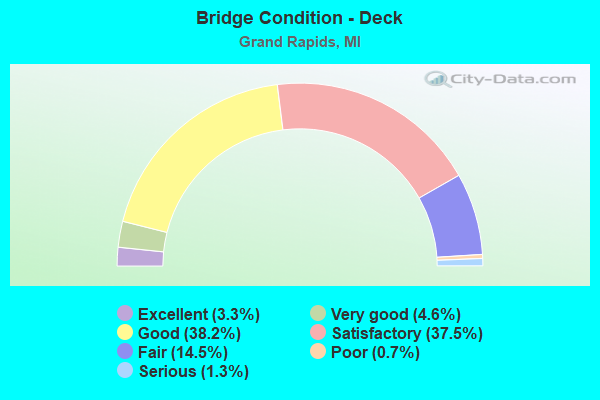
- Bridge Condition - Deck
- 3.3%Excellent
- 4.6%Very good
- 38.2%Good
- 37.5%Satisfactory
- 14.5%Fair
- 0.7%Poor
- 1.3%Serious
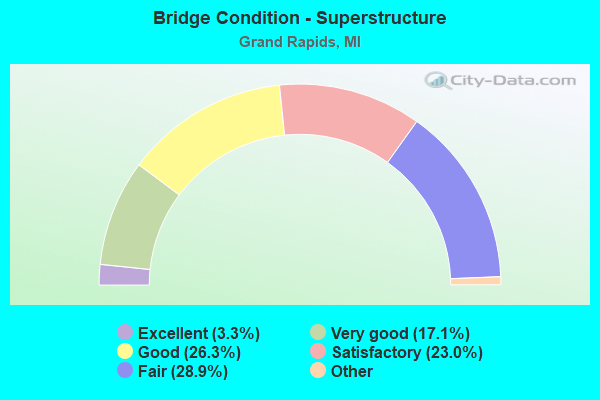
- Bridge Condition - Superstructure
- 3.3%Excellent
- 17.1%Very good
- 26.3%Good
- 23.0%Satisfactory
- 28.9%Fair
- 1.3%Poor
- 0.7%Serious
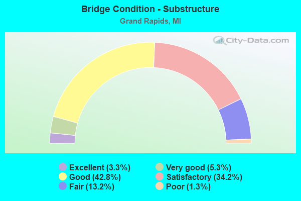
- Bridge Condition - Substructure
- 3.3%Excellent
- 5.3%Very good
- 42.8%Good
- 34.2%Satisfactory
- 13.2%Fair
- 1.3%Poor
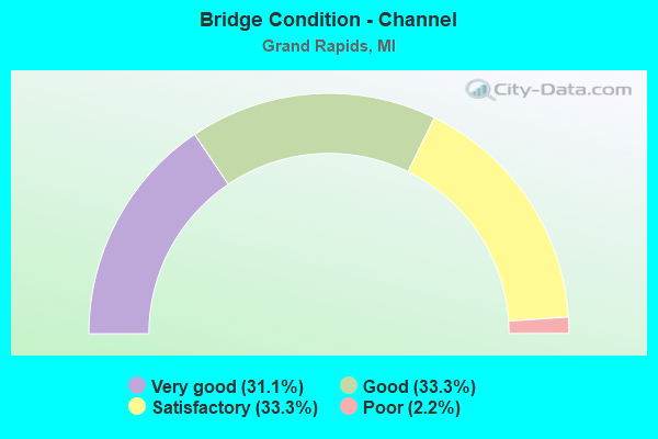
- Bridge Condition - Channel
- 31.1%Very good
- 33.3%Good
- 33.3%Satisfactory
- 2.2%Poor
Find on map >> Show street view
Structure Number: 12841, Location: 0.1 MI W OF BOSTWICK (Lat: 42.967300, Lng: -85.667047), Route carried "under" structure: City street , Year Built: 1995, Structure Length: 0. m, Average Daily Traffic: 1,200 (year 0000), Features Intersected: LYON STREET, Facility Carried by Structure: GRCC PEDESTRAIN
Minimum Vertical Clearance: 4.88m (16.01ft), Kilometerpoint: 0.583, Lanes under structure: 2, Material/Design: Steel, Design/Construction: Truss - Thru, Length of Maximum Span: 13.4m (44.0ft)
Find on map >> Show street view
Structure Number: 12843, Location: 0.1 MI S OF MICHIGAN AVE (Lat: 42.969953, Lng: -85.663767), Route carried "under" structure: City street , Year Built: 1995, Structure Length: 0. m, Average Daily Traffic: 1,200 (year 2007), Features Intersected: BARCLAY STREET, Facility Carried by Structure: BUTTERWORTH PED
Minimum Vertical Clearance: 4.72m (15.49ft), Kilometerpoint: 0.288, Lanes under structure: 2, Material/Design: Steel, Design/Construction: Truss - Thru, Length of Maximum Span: 32.9m (107.9ft)
Find on map >> Show street view
Structure Number: 12844, Location: 0.1 MI S OF FULTON ST (Lat: 42.962717, Lng: -85.673778), Route carried "under" structure: City street , Year Built: 1997, Structure Length: 0. m, Average Daily Traffic: 2,400 (year 0000), Features Intersected: MARKET AVENUE, Facility Carried by Structure: VAN ANDEL WALKOVER
Minimum Vertical Clearance: 7.29m (23.92ft), Kilometerpoint: 10.126, Lanes under structure: 4, Material/Design: Steel, Design/Construction: Truss - Thru, Length of Maximum Span: 27.7m (90.9ft)
Find on map >> Show street view
Structure Number: 12845, Location: 0.1 MI S OF FULTON ST (Lat: 42.962603, Lng: -85.672403), Route carried "under" structure: City street , Year Built: 1997, Structure Length: 0. m, Average Daily Traffic: 2,400 (year 2007), Features Intersected: OTTAWA AVENUE, Facility Carried by Structure: VAN ANDEL WALKOVER
Minimum Vertical Clearance: 4.72m (15.49ft), Kilometerpoint: 0.188, Lanes under structure: 4, Material/Design: Steel, Design/Construction: Truss - Thru, Length of Maximum Span: 25.0m (82.0ft)
Find on map >> Show street view
Structure Number: 12846, Location: 0.1 MI S OF FULTON ST (Lat: 42.962572, Lng: -85.672964), Route carried "under" structure: City street , Year Built: 1997, Structure Length: 0. m, Average Daily Traffic: 800 (year 2007), Features Intersected: OTTAWA ALLEY, Facility Carried by Structure: VAN ANDEL WALKOVER
Minimum Vertical Clearance: 4.72m (15.49ft), Kilometerpoint: 0.043, Lanes under structure: 2, Material/Design: Steel, Design/Construction: Truss - Thru, Length of Maximum Span: 7.6m (24.9ft)
Find on map >> Show street view
Structure Number: 12848, Location: 0.1 MI W OF MONROE AVE (Lat: 42.963242, Lng: -85.673978), Route carried "under" structure: City street , Year Built: 1997, Structure Length: 0. m, Average Daily Traffic: 2,600 (year 0000), Features Intersected: FULTON ST (OLD M-45), Facility Carried by Structure: VAN ANDEL ARENA
Minimum Vertical Clearance: 6.48m (21.26ft), Kilometerpoint: 2.475, Lanes under structure: 4, Material/Design: Steel, Design/Construction: Truss - Thru, Length of Maximum Span: 29.0m (95.1ft)
Find on map >> Show street view
Structure Number: 12866, Location: IN GRAND RAPIDS (Lat: 42.961600, Lng: -85.676706), Route carried "under" structure: City street 2001, Year Built: 1999, Structure Length: 0. m, Average Daily Traffic: 11,470 (year 2007), Features Intersected: GRAND RIVER & FULTON ST, Facility Carried by Structure: US-131 NB
Minimum Vertical Clearance: 4.80m (15.75ft), Kilometerpoint: 2.107, Lanes on structure: 5, Lanes under structure: 2, Material/Design: Steel continuous, Design/Construction: Stringer/Multi-beam, Length of Maximum Span: 55.3m (181.4ft)
Find on map >> Show street view
Structure Number: 12867, Location: IN GRAND RAPIDS (Lat: 42.961308, Lng: -85.676906), Route carried "under" structure: City street 2001, Year Built: 1999, Structure Length: 0. m, Average Daily Traffic: 11,470 (year 2007), Features Intersected: GRAND RIVER & FULTON ST, Facility Carried by Structure: US-131 SB
Minimum Vertical Clearance: 5.33m (17.49ft), Kilometerpoint: 2.089, Lanes on structure: 5, Lanes under structure: 2, Material/Design: Steel continuous, Design/Construction: Stringer/Multi-beam, Length of Maximum Span: 57.3m (188.0ft)
Find on map >> Show street view
Structure Number: 12868, Location: IN GRAND RAPIDS (Lat: 42.958933, Lng: -85.671486), Route carried "under" structure: City street 2001, Year Built: 1999, Structure Length: 0. m, Average Daily Traffic: 3,662 (year 2007), Features Intersected: GRANDVILLE AVENUE, Facility Carried by Structure: US-131 NB
Minimum Vertical Clearance: 30+ m (98+ ft), Kilometerpoint: 0.343, Lanes on structure: 5, Lanes under structure: 2, Material/Design: Steel, Design/Construction: Stringer/Multi-beam, Length of Maximum Span: 61.2m (200.8ft)
Find on map >> Show street view
Structure Number: 12869, Location: IN GRAND RAPIDS (Lat: 42.959694, Lng: -85.672447), Route carried "under" structure: City street 2001, Year Built: 1999, Structure Length: 0. m, Average Daily Traffic: 3,662 (year 2007), Features Intersected: GRANDVILLE AVENUE, Facility Carried by Structure: US-131 SB
Minimum Vertical Clearance: 6.07m (19.91ft), Kilometerpoint: 11.778, Lanes on structure: 4, Lanes under structure: 2, Material/Design: Steel, Design/Construction: Stringer/Multi-beam, Length of Maximum Span: 56.8m (186.4ft)
Find on map >> Show street view
Structure Number: 12947, Location: 0.1 MI N OF LYON STREET (Lat: 42.967586, Lng: -85.666425), Route carried "under" structure: City street , Year Built: 2000, Structure Length: 0. m, Average Daily Traffic: 6,500 (year 1999), Features Intersected: BOSTWICK AVENUE, Facility Carried by Structure: GRCC PEDESTRIAN
Minimum Vertical Clearance: 8.69m (28.51ft), Kilometerpoint: 0.361, Lanes under structure: 2, Material/Design: Steel, Design/Construction: Truss - Thru, Length of Maximum Span: 22.1m (72.5ft)
Find on map >> Show street view
Structure Number: 12957, Location: IN GRAND RAPIDS (Lat: 42.964681, Lng: -85.678656), Route carried "under" structure: City street , Year Built: 2000, Structure Length: 0. m, Average Daily Traffic: 2,500 (year 1999), Features Intersected: FRONT AVENUE, Facility Carried by Structure: US-131 NB
Minimum Vertical Clearance: 5.21m (17.09ft), Kilometerpoint: 0.053, Lanes on structure: 5, Lanes under structure: 2, Material/Design: Prestressed concrete, Design/Construction: Stringer/Multi-beam, Length of Maximum Span: 26.0m (85.3ft)
Find on map >> Show street view
Structure Number: 12958, Location: IN GRAND RAPIDS (Lat: 42.964683, Lng: -85.678878), Route carried "under" structure: City street , Year Built: 2000, Structure Length: 0. m, Average Daily Traffic: 2,500 (year 2000), Features Intersected: FRONT AVENUE, Facility Carried by Structure: US-131 SB
Minimum Vertical Clearance: 6.10m (20.01ft), Kilometerpoint: 0.034, Lanes on structure: 5, Lanes under structure: 2, Material/Design: Prestressed concrete, Design/Construction: Stringer/Multi-beam, Length of Maximum Span: 26.0m (85.3ft)
Find on map >> Show street view
Structure Number: 13041, Location: 1000 FT N OF BURTON ST (Lat: 42.928536, Lng: -85.584528), Route carried "under" structure: State highway 37, Year Built: 2002, Structure Length: 0. m, Average Daily Traffic: 48,092 (year 2007), Features Intersected: M-37 (E BELT LINE AVE), Facility Carried by Structure: CALVIN COLLEGE PED
Minimum Vertical Clearance: 5.72m (18.77ft), Kilometerpoint: 15.153, Lanes under structure: 4, Material/Design: Steel, Design/Construction: Truss - Thru, Length of Maximum Span: 28.5m (93.5ft)
Find on map >> Show street view
Structure Number: 13083, Location: IN GRAND RAPIDS (Lat: 42.960642, Lng: -85.675150), Route carried "under" structure: City street 2001, Year Built: 2000, Structure Length: 0. m, Average Daily Traffic: 9,528 (year 1992), Features Intersected: MARKET AVE, Facility Carried by Structure: US-131 SB
Minimum Vertical Clearance: 6.12m (20.08ft), Kilometerpoint: 9.869, Lanes on structure: 4, Lanes under structure: 2, Material/Design: Prestressed concrete, Design/Construction: Stringer/Multi-beam, Length of Maximum Span: 44.6m (146.3ft)
Find on map >> Show street view
Structure Number: 13084, Location: IN GRAND RAPIDS (Lat: 42.966622, Lng: -85.678744), Route carried "under" structure: City street , Year Built: 2000, Structure Length: 0. m, Average Daily Traffic: 10,945 (year 1992), Features Intersected: PEARL STREET, Facility Carried by Structure: US-131 SB
Minimum Vertical Clearance: 4.62m (15.16ft), Kilometerpoint: 0.208, Lanes on structure: 4, Lanes under structure: 4, Material/Design: Prestressed concrete, Design/Construction: Box Beam or Girders - Multiple, Length of Maximum Span: 25.8m (84.6ft)
Find on map >> Show street view
Structure Number: 13477, Location: 0.1 MI S OF PEARL ST (Lat: 42.998819, Lng: -85.673444), Route carried "under" structure: City street , Year Built: 2007, Structure Length: 0. m, Average Daily Traffic: 850 (year 1994), Features Intersected: CAMPAU STREET, Facility Carried by Structure: JW MARRIOT WALKOVR
Minimum Vertical Clearance: 5.64m (18.50ft), Kilometerpoint: 0.195, Lanes under structure: 3, Material/Design: Steel, Design/Construction: Truss - Thru, Length of Maximum Span: 20.6m (67.6ft)
Find on map >> Show street view
Structure Number: 13478, Location: 0.4 MI E OF DIVISION AVE (Lat: 42.970411, Lng: -85.666781), Route carried "under" structure: City street , Year Built: 2007, Structure Length: 0. m, Average Daily Traffic: 11,000 (year 1992), Features Intersected: MICHIGAN AVE, Facility Carried by Structure: VAI PEDESTRAIN
Minimum Vertical Clearance: 7.47m (24.51ft), Kilometerpoint: 4.350, Lanes under structure: 3, Material/Design: Steel, Design/Construction: Truss - Thru, Length of Maximum Span: 35.7m (117.1ft)
Find on map >> Show street view
Structure Number: 13752, Location: IN GRAND RAPIDS (Lat: 42.992092, Lng: -85.676989), Route carried "under" structure: City street 2001, Year Built: 1961, Structure Length: 0. m, Average Daily Traffic: 8,935 (year 1990), Features Intersected: RICHMOND STREET, Facility Carried by Structure: I-296 EB/US-131 NB
Minimum Vertical Clearance: 5.99m (19.65ft), Kilometerpoint: 3.166, Lanes on structure: 4, Lanes under structure: 4, Material/Design: Steel, Design/Construction: Stringer/Multi-beam, Length of Maximum Span: 16.7m (54.8ft)
Find on map >> Show street view
Structure Number: 13753, Location: IN GRAND RAPIDS (ANN ST) (Lat: 42.995669, Lng: -85.676094), Route carried "under" structure: City street 2001, Year Built: 1962, Structure Length: 0. m, Average Daily Traffic: 17,300 (year 1992), Truck Traffic: 1%, Features Intersected: ANN STREET, Facility Carried by Structure: I-296 EB/US-131 NB
Minimum Vertical Clearance: 6.10m (20.01ft), Kilometerpoint: 1.151, Lanes on structure: 4, Lanes under structure: 4, Material/Design: Steel, Design/Construction: Stringer/Multi-beam, Length of Maximum Span: 20.3m (66.6ft)
Find on map >> Show street view
Structure Number: 13818, Location: IN GRAND RAPIDS (Lat: 42.984861, Lng: -85.677197), Route carried "under" structure: Business US 131, Year Built: 1961, Structure Length: 0. m, Average Daily Traffic: 22,078 (year 2007), Truck Traffic: 1%, Features Intersected: US-131 BR (LEONARD)
Minimum Vertical Clearance: 30+ m (98+ ft), Kilometerpoint: 0.803, Lanes on structure: 3, Lanes under structure: 4, Material/Design: Steel, Design/Construction: Stringer/Multi-beam, Length of Maximum Span: 20.4m (66.9ft)
Find on map >> Show street view
Structure Number: 14033, Location: I-96/I-196 INTERCHANGE (Lat: 42.976861, Lng: -85.603350), Route carried "under" structure: Interstate 196, Year Built: 2019, Structure Length: 0. m, Average Daily Traffic: 71,650 (year 2019), Truck Traffic: 3%, Features Intersected: I-196 WB, Facility Carried by Structure: I-96 EB
Minimum Vertical Clearance: 5.26m (17.26ft), Kilometerpoint: 0.000, Lanes on structure: 2, Lanes under structure: 3, Material/Design: Steel, Design/Construction: Stringer/Multi-beam, Length of Maximum Span: 66.1m (216.9ft)
Find on map >> Show street view
Structure Number: 14035, Location: I-96/I-196 INTERCHANGE (Lat: 42.976919, Lng: -85.605381), Route carried "under" structure: Interstate 196, Year Built: 2019, Structure Length: 0. m, Average Daily Traffic: 71,650 (year 2019), Truck Traffic: 3%, Features Intersected: I-196 WB, Facility Carried by Structure: I-96 EB RAMP B
Minimum Vertical Clearance: 4.95m (16.24ft), Kilometerpoint: 0.000, Lanes on structure: 1, Lanes under structure: 5, Material/Design: Steel continuous, Design/Construction: Stringer/Multi-beam, Length of Maximum Span: 69.5m (228.0ft)