Bridge Statistics for Grand Rapids, Michigan (MI)
Condition, Traffic, Stress, Structural Evaluation, Project Costs
- National Bridge Inventory (NBI) Statistics
- 269Number of bridges
- 4,331ft / 1,320mTotal length
- $3,922,000Total costs
- 6,381,085Total average daily traffic
- 408,489Total average daily truck traffic
- National Bridge Inventory (NBI) Registered Bridges for Grand Rapids
- No street view available for this location
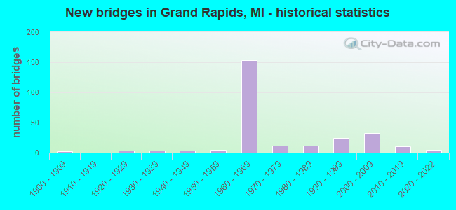
- New bridges - historical statistics
- 1Before 1900
- 21900-1909
- 41920-1929
- 31930-1939
- 41940-1949
- 51950-1959
- 1531960-1969
- 121970-1979
- 121980-1989
- 251990-1999
- 332000-2009
- 102010-2019
- 52020-2022
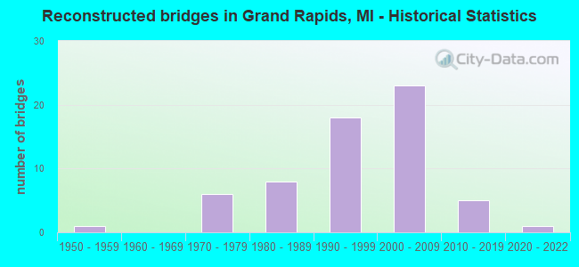
- Reconstructed bridges - Historical Statistics
- 11950-1959
- 01960-1969
- 61970-1979
- 81980-1989
- 181990-1999
- 232000-2009
- 52010-2019
- 12020-2022
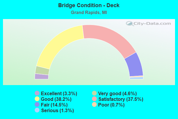
- Bridge Condition - Deck
- 3.3%Excellent
- 4.6%Very good
- 38.2%Good
- 37.5%Satisfactory
- 14.5%Fair
- 0.7%Poor
- 1.3%Serious
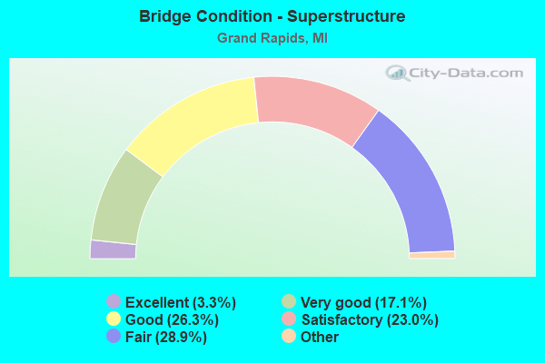
- Bridge Condition - Superstructure
- 3.3%Excellent
- 17.1%Very good
- 26.3%Good
- 23.0%Satisfactory
- 28.9%Fair
- 1.3%Poor
- 0.7%Serious
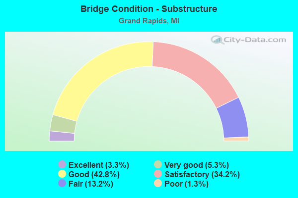
- Bridge Condition - Substructure
- 3.3%Excellent
- 5.3%Very good
- 42.8%Good
- 34.2%Satisfactory
- 13.2%Fair
- 1.3%Poor
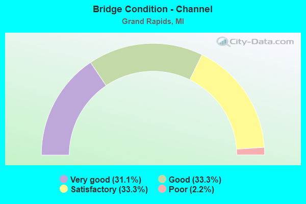
- Bridge Condition - Channel
- 31.1%Very good
- 33.3%Good
- 33.3%Satisfactory
- 2.2%Poor
Find on map >> Show street view
Structure Number: 5098, Location: 125 FT SOUTH OF 32ND ST (Lat: 42.905433, Lng: -85.627222), Route carried "on" structure: Business City street 2001, Year Built: 1927, Year Reconstructed: 1991, Status: Open, Structure Length: 1.37m (4.49ft), Average Daily Traffic: 20,993 (year 2016), Truck Traffic: 2%, Average Future Daily Traffic: 25,615 (year 2036), Design Load: HS 20, Features Intersected: PLASTER CREEK, Facility Carried by Structure: KALAMAZOO AVENUE
Minimum Vertical Clearance: 30.48m (100.00ft), Kilometerpoint: 15.500, Lanes on structure: 4, Owner: City or Municipal Highway Agency, Approaching Roadway Width: 13.4m (44.0ft), Material/Design: Prestressed concrete, Design/Construction: Box Beam or Girders - Multiple, Number Of Spans In Main Unit: 1, Length of Maximum Span: 13.7m (44.9ft), Curb or Sidewalk Widths: Left: 2.5m (8.2ft), Right: 2.4m (7.9ft), Curb-To-Curb Width: 16.2m (53.1ft), Out-to-Out Width: 21.8m (71.5ft)
Condition: Deck: Good, Superstructure: Good, Substructure: Good, Channel: Satisfactory, Operating Rating: 84.5 metric tons, Method Used To Determine Operating Rating: Load Factor (LF), Inventory Rating: 50.6 metric tons, Method Used To Determine Inventory Rating: Load Factor (LF), Structural Evaluation: Better than present minimum criteria, Deck Geometry: Meets minimum limits, Waterway Adequacy: Better than present minimum criteria, Approach Roadway Alignment: Equal to present desirable criteria, Designated Inspection Frequency: Every 24 months, Inspection Date: August 2021, Deck Structure Type: Concrete Cast-file-Place, Wearing Surface/Protective System: Wearing Surface: Monolithic Concrete, Deck Protection: Epoxy Coated Reinforcing
Find on map >> Show street view
Structure Number: 5186, Location: EAST OF US-131 (Lat: 42.966481, Lng: -85.674525), Route carried "on" structure: Business City street 2001, Year Built: 1922, Year Reconstructed: 1983, Status: Open, Structure Length: 14.75m (48.39ft), Average Daily Traffic: 17,945 (year 2007), Average Future Daily Traffic: 24,170 (year 2007), Design Load: HS 25 or greater, Features Intersected: GRAND RIVER, Facility Carried by Structure: PEARL STREET
Minimum Vertical Clearance: 30.48m (100.00ft), Kilometerpoint: 0.415, Lanes on structure: 4, Owner: City or Municipal Highway Agency, Approaching Roadway Width: 14.9m (48.9ft), Material/Design: Prestressed concrete, Design/Construction: Stringer/Multi-beam, Number Of Spans In Main Unit: 5, Number Of Approach Spans: 1, Length of Maximum Span: 29.8m (97.8ft), Curb or Sidewalk Widths: Left: 2.7m (8.9ft), Right: 2.7m (8.9ft), Curb-To-Curb Width: 14.9m (48.9ft), Out-to-Out Width: 20.8m (68.2ft)
Condition: Deck: Good, Superstructure: Good, Substructure: Satisfactory, Channel: Very good, Inventory Rating: 62.9 metric tons, Method Used To Determine Inventory Rating: Load Factor (LF), Structural Evaluation: Equal to present minimum criteria, Deck Geometry: High priority of replacement, Waterway Adequacy: Equal to present minimum criteria, Approach Roadway Alignment: Equal to present desirable criteria, Designated Inspection Frequency: Every 24 months, Inspection Date: August 2021, Deck Structure Type: Concrete Cast-file-Place, Wearing Surface/Protective System: Wearing Surface: Monolithic Concrete, Deck Protection: Epoxy Coated Reinforcing
Find on map >> Show street view
Structure Number: 5188, Location: GRAND RAPIDS (Lat: 42.948639, Lng: -85.698392), Route carried "on" structure: Business City street 2001, Year Built: 1993, Status: Open, Structure Length: 3.66m (12.01ft), Average Daily Traffic: 8,016 (year 2016), Truck Traffic: 5%, Average Future Daily Traffic: 9,781 (year 2036), Design Load: HS 25 or greater, Features Intersected: PLASTER CREEK, Facility Carried by Structure: MARKET AVENUE
Minimum Vertical Clearance: 30.48m (100.00ft), Kilometerpoint: 7.490, Lanes on structure: 2, Owner: City or Municipal Highway Agency, Approaching Roadway Width: 15.5m (50.9ft), Material/Design: Concrete continuous, Design/Construction: Stringer/Multi-beam, Number Of Spans In Main Unit: 3, Length of Maximum Span: 24.4m (80.1ft), Curb or Sidewalk Widths: Left: 3.0m (9.8ft), Right: 3.0m (9.8ft), Curb-To-Curb Width: 15.5m (50.9ft), Out-to-Out Width: 22.4m (73.5ft)
Condition: Deck: Good, Superstructure: Good, Substructure: Very good, Channel: Good, Operating Rating: 88.6 metric tons, Method Used To Determine Operating Rating: Allowable Stress (AS), Inventory Rating: 34.6 metric tons, Method Used To Determine Inventory Rating: Allowable Stress (AS), Structural Evaluation: Better than present minimum criteria, Deck Geometry: Superior to present desirable criteria, Waterway Adequacy: Equal to present minimum criteria, Approach Roadway Alignment: Equal to present desirable criteria, Designated Inspection Frequency: Every 24 months, Inspection Date: August 2021, Deck Structure Type: Concrete Cast-file-Place, Wearing Surface/Protective System: Wearing Surface: Monolithic Concrete
Find on map >> Show street view
Structure Number: 5192, Location: GRAND RAPIDS (Lat: 42.976622, Lng: -85.673311), Route carried "on" structure: Business City street 2001, Year Built: 1886, Year Reconstructed: 2011, Status: Posted for load, Structure Length: 16.60m (54.46ft), Average Daily Traffic: 4,550 (year 2011), Average Future Daily Traffic: 7,450 (year 2031), Design Load: H 15, Features Intersected: GRAND RIVER, Facility Carried by Structure: SIXTH STREET
Minimum Vertical Clearance: 30.48m (100.00ft), Kilometerpoint: 1.139, Lanes on structure: 2, Owner: City or Municipal Highway Agency, Approaching Roadway Width: 9.1m (29.9ft), Material/Design: Steel, Design/Construction: Truss - Thru, Number Of Spans In Main Unit: 4, Length of Maximum Span: 46.1m (151.2ft), Curb or Sidewalk Widths: Left: 1.9m (6.2ft), Right: 1.9m (6.2ft), Curb-To-Curb Width: 5.6m (18.4ft), Out-to-Out Width: 10.6m (34.8ft)
Condition: Deck: Good, Superstructure: Fair, Substructure: Good, Channel: Good, Operating Rating: 7.1 metric tons, Method Used To Determine Operating Rating: Load Factor (LF) rating reported by rating factor (RF) method using MS18 loading, Inventory Rating: 3.9 metric tons, Method Used To Determine Inventory Rating: Load Factor (LF) rating reported by rating factor (RF) method using MS18 loading, Structural Evaluation: High priority of corrective action, Deck Geometry: High priority of replacement, Waterway Adequacy: Equal to present minimum criteria, Approach Roadway Alignment: Better than present minimum criteria, Bridge Posting: Required (Relationship of Operating Rating to Maximum Legal Load: > 39.9% below), Designated Inspection Frequency: Every 12 months, Critical Feature Inspection Frequency: Every 24 months, Underwater Inspection Frequency: Every 60 months, Inspection Date: August 2021, Critical Feature Inspection Date: October 2021, Underwater Inspection Date: August 2020, Deck Structure Type: Closed Grating, Wearing Surface/Protective System: Wearing Surface: Monolithic Concrete
Find on map >> Show street view
Structure Number: 5193, Location: GRAND RAPIDS (Lat: 42.995539, Lng: -85.672136), Route carried "on" structure: Business City street 2001, Year Built: 1971, Status: Open, Structure Length: 20.42m (66.99ft), Average Daily Traffic: 14,834 (year 2018), Truck Traffic: 10%, Average Future Daily Traffic: 16,390 (year 2038), Design Load: HS 20+Mod, Features Intersected: GRAND RIVER, Facility Carried by Structure: ANN STREET
Minimum Vertical Clearance: 30.48m (100.00ft), Kilometerpoint: 1.299, Lanes on structure: 4, Owner: City or Municipal Highway Agency, Approaching Roadway Width: 15.9m (52.2ft), Material/Design: Steel continuous, Design/Construction: Stringer/Multi-beam, Number Of Spans In Main Unit: 5, Length of Maximum Span: 44.5m (146.0ft), Curb or Sidewalk Widths: Left: 1.8m (5.9ft), Right: 1.8m (5.9ft), Curb-To-Curb Width: 14.6m (47.9ft), Out-to-Out Width: 19.0m (62.3ft)
Condition: Deck: Satisfactory, Superstructure: Good, Substructure: Satisfactory, Channel: Good, Operating Rating: 82.0 metric tons, Method Used To Determine Operating Rating: Load Factor (LF), Inventory Rating: 49.1 metric tons, Method Used To Determine Inventory Rating: Load Factor (LF), Structural Evaluation: Equal to present minimum criteria, Deck Geometry: High priority of replacement, Waterway Adequacy: Equal to present desirable criteria, Approach Roadway Alignment: Equal to present desirable criteria, Designated Inspection Frequency: Every 24 months, Underwater Inspection Frequency: Every 60 months, Inspection Date: August 2021, Underwater Inspection Date: August 2020, Deck Structure Type: Concrete Cast-file-Place, Wearing Surface/Protective System: Wearing Surface: Latex Concrete
Find on map >> Show street view
Structure Number: 5194, Location: GRAND RAPIDS (Lat: 43.022528, Lng: -85.660697), Route carried "on" structure: Business City street 2001, Year Built: 1991, Status: Open, Structure Length: 20.64m (67.72ft), Average Daily Traffic: 11,091 (year 2018), Truck Traffic: 15%, Average Future Daily Traffic: 12,254 (year 2038), Design Load: HS 25 or greater, Features Intersected: GRAND RIVER, Facility Carried by Structure: NORTH PARK STREET
Minimum Vertical Clearance: 30.48m (100.00ft), Kilometerpoint: 0.740, Lanes on structure: 3, Owner: City or Municipal Highway Agency, Approaching Roadway Width: 6.1m (20.0ft), Skew: 2 degrees, Material/Design: Prestressed concrete, Design/Construction: Stringer/Multi-beam, Number Of Spans In Main Unit: 6, Length of Maximum Span: 34.4m (112.9ft), Curb or Sidewalk Widths: Left: 2.4m (7.9ft), Right: 2.4m (7.9ft), Curb-To-Curb Width: 14.6m (47.9ft), Out-to-Out Width: 20.4m (66.9ft)
Condition: Deck: Good, Superstructure: Very good, Substructure: Very good, Channel: Good, Inventory Rating: 63.0 metric tons, Method Used To Determine Inventory Rating: Load Factor (LF), Structural Evaluation: Equal to present desirable criteria, Deck Geometry: Somewhat better than minimum adequacy, Waterway Adequacy: Equal to present desirable criteria, Approach Roadway Alignment: Equal to present desirable criteria, Designated Inspection Frequency: Every 24 months, Underwater Inspection Frequency: Every 60 months, Inspection Date: August 2021, Underwater Inspection Date: August 2020, Deck Structure Type: Concrete Cast-file-Place, Wearing Surface/Protective System: Wearing Surface: Epoxy Overlay, Deck Protection: Epoxy Coated Reinforcing
Find on map >> Show street view
Structure Number: 5197, Location: GRAND RAPIDS (Lat: 42.918053, Lng: -85.666219), Route carried "on" structure: Business City street 2001, Year Built: 2007, Status: Open, Structure Length: 2.13m (6.99ft), Average Daily Traffic: 24,113 (year 2007), Truck Traffic: 5%, Average Future Daily Traffic: 29,422 (year 2027), Design Load: HS 20+Mod, Features Intersected: PLASTER CREEK, Facility Carried by Structure: DIVISION AVENUE
Minimum Vertical Clearance: 30.48m (100.00ft), Kilometerpoint: 17.559, Lanes on structure: 4, Base Highway Network: Yes (Inventory Route: 303, Subroute: 81), Owner: City or Municipal Highway Agency, Approaching Roadway Width: 17.4m (57.1ft), Material/Design: Prestressed concrete, Design/Construction: Box Beam or Girders - Single/Spread, Number Of Spans In Main Unit: 1, Length of Maximum Span: 19.8m (65.0ft), Curb or Sidewalk Widths: Left: 3.7m (12.1ft), Right: 3.7m (12.1ft), Curb-To-Curb Width: 17.4m (57.1ft), Out-to-Out Width: 25.7m (84.3ft)
Condition: Deck: Good, Superstructure: Very good, Substructure: Very good, Channel: Very good, Operating Rating: 97.2 metric tons, Method Used To Determine Operating Rating: Load Factor (LF) rating reported by rating factor (RF) method using MS18 loading, Inventory Rating: 61.2 metric tons, Method Used To Determine Inventory Rating: Load Factor (LF) rating reported by rating factor (RF) method using MS18 loading, Structural Evaluation: Equal to present desirable criteria, Deck Geometry: Somewhat better than minimum adequacy, Waterway Adequacy: Better than present minimum criteria, Approach Roadway Alignment: Better than present minimum criteria, Designated Inspection Frequency: Every 24 months, Inspection Date: August 2021, Deck Structure Type: Concrete Cast-file-Place, Wearing Surface/Protective System: Wearing Surface: Integral Concrete, Deck Protection: Epoxy Coated Reinforcing
Find on map >> Show street view
Structure Number: 5198, Location: 300 FT WEST OF MARKET AVE (Lat: 42.956119, Lng: -85.681550), Route carried "on" structure: Business County highway 2001, Year Built: 1976, Year Reconstructed: 2008, Status: Open, Structure Length: 17.13m (56.20ft), Average Daily Traffic: 12,230 (year 2006), Truck Traffic: 15%, Average Future Daily Traffic: 15,300 (year 2026), Design Load: HS 20+Mod, Features Intersected: GRAND RIVER, Facility Carried by Structure: WEALTHY STREET
Minimum Vertical Clearance: 30.48m (100.00ft), Kilometerpoint: 0.491, Lanes on structure: 4, Owner: City or Municipal Highway Agency, Approaching Roadway Width: 15.9m (52.2ft), Skew: 3 degrees, Navigation Control: Yes ( Vertical Clearance: 7.2m (23.6ft), Horizontal Clearance: 20.8m (68.2ft)), Material/Design: Steel continuous, Design/Construction: Stringer/Multi-beam, Number Of Spans In Main Unit: 6, Length of Maximum Span: 32.3m (106.0ft), Curb or Sidewalk Widths: Left: 2.1m (6.9ft), Right: 2.1m (6.9ft), Curb-To-Curb Width: 15.9m (52.2ft), Out-to-Out Width: 20.8m (68.2ft)
Condition: Deck: Good, Superstructure: Good, Substructure: Good, Channel: Very good, Inventory Rating: 82.9 metric tons, Method Used To Determine Inventory Rating: Load Factor (LF), Structural Evaluation: Better than present minimum criteria, Deck Geometry: Meets minimum limits, Waterway Adequacy: Equal to present desirable criteria, Approach Roadway Alignment: Better than present minimum criteria, Designated Inspection Frequency: Every 24 months, Inspection Date: August 2021, Deck Structure Type: Concrete Cast-file-Place, Wearing Surface/Protective System: Wearing Surface: Latex Concrete
Find on map >> Show street view
Structure Number: 52, Location: 0.5 MI NORTH OF RICHMOND (Lat: 43.000497, Lng: -85.718050), Route carried "on" structure: Business County highway 2001, Year Built: 1985, Status: Open, Structure Length: 1.49m (4.89ft), Average Daily Traffic: 8,062 (year 2015), Truck Traffic: 2%, Average Future Daily Traffic: 8,474 (year 2035), Design Load: HS 20+Mod, Features Intersected: INDIAN MILL CREEK, Facility Carried by Structure: WALKER AVENUE
Minimum Vertical Clearance: 30.48m (100.00ft), Kilometerpoint: 3.674, Lanes on structure: 2, Owner: City or Municipal Highway Agency, Approaching Roadway Width: 11.0m (36.1ft), Material/Design: Prestressed concrete, Design/Construction: Box Beam or Girders - Multiple, Number Of Spans In Main Unit: 1, Length of Maximum Span: 13.7m (44.9ft), Curb or Sidewalk Widths: Left: 1.9m (6.2ft), Right: 1.9m (6.2ft), Curb-To-Curb Width: 11.0m (36.1ft), Out-to-Out Width: 15.4m (50.5ft)
Condition: Deck: Satisfactory, Superstructure: Satisfactory, Substructure: Good, Channel: Satisfactory, Operating Rating: 68.4 metric tons, Method Used To Determine Operating Rating: Load Factor (LF), Inventory Rating: 41.0 metric tons, Method Used To Determine Inventory Rating: Load Factor (LF), Structural Evaluation: Equal to present minimum criteria, Deck Geometry: Meets minimum limits, Waterway Adequacy: Equal to present desirable criteria, Approach Roadway Alignment: Equal to present desirable criteria, Designated Inspection Frequency: Every 24 months, Inspection Date: August 2021, Deck Structure Type: Concrete Precast Panels, Wearing Surface/Protective System: Wearing Surface: Bituminous, Membrane: Preformed Fabric, Deck Protection: Epoxy Coated Reinforcing
Find on map >> Show street view
Structure Number: 5201, Location: 0.2 MI SOUTH OF ANN ST (Lat: 42.997044, Lng: -85.688383), Route carried "on" structure: Business County highway 2001, Year Built: 2007, Status: Open, Structure Length: 1.56m (5.12ft), Average Daily Traffic: 22,440 (year 2006), Truck Traffic: 5%, Average Future Daily Traffic: 27,000 (year 2026), Design Load: HS 20+Mod, Features Intersected: INDIAN MILL CREEK, Facility Carried by Structure: ALPINE AVENUE
Minimum Vertical Clearance: 30.48m (100.00ft), Kilometerpoint: 2.379, Lanes on structure: 4, Base Highway Network: Yes (Inventory Route: 42, Subroute: 10), Owner: City or Municipal Highway Agency, Approaching Roadway Width: 14.9m (48.9ft), Skew: 1 degrees, Material/Design: Steel, Design/Construction: Stringer/Multi-beam, Number Of Spans In Main Unit: 1, Length of Maximum Span: 13.7m (44.9ft), Curb or Sidewalk Widths: Left: 3.7m (12.1ft), Right: 3.7m (12.1ft), Curb-To-Curb Width: 14.6m (47.9ft), Out-to-Out Width: 22.9m (75.1ft)
Condition: Deck: Good, Superstructure: Very good, Substructure: Very good, Channel: Satisfactory, Inventory Rating: 76.5 metric tons, Method Used To Determine Inventory Rating: Load Factor (LF), Structural Evaluation: Equal to present desirable criteria, Deck Geometry: High priority of replacement, Waterway Adequacy: Equal to present desirable criteria, Approach Roadway Alignment: Equal to present desirable criteria, Designated Inspection Frequency: Every 24 months, Inspection Date: August 2021, Deck Structure Type: Concrete Cast-file-Place, Wearing Surface/Protective System: Wearing Surface: Integral Concrete, Deck Protection: Epoxy Coated Reinforcing
Find on map >> Show street view
Structure Number: 5204, Location: GRAND RAPIDS (Lat: 42.973753, Lng: -85.657022), Route carried "on" structure: Business City street 2001, Year Built: 2008, Status: Open, Structure Length: 2.13m (6.99ft), Average Daily Traffic: 9,200 (year 2005), Truck Traffic: 7%, Average Future Daily Traffic: 15,300 (year 2026), Design Load: HS 25 or greater, Features Intersected: GRAND TRUNK RR, Facility Carried by Structure: COLLEGE AVENUE
Minimum Vertical Clearance: 30.48m (100.00ft), Kilometerpoint: 2.995, Lanes on structure: 4, Owner: City or Municipal Highway Agency, Approaching Roadway Width: 11.0m (36.1ft), Skew: 2 degrees, Material/Design: Prestressed concrete, Design/Construction: Box Beam or Girders - Multiple, Number Of Spans In Main Unit: 1, Length of Maximum Span: 19.6m (64.3ft), Curb or Sidewalk Widths: Left: 4.9m (16.1ft), Right: 4.9m (16.1ft), Curb-To-Curb Width: 11.0m (36.1ft), Out-to-Out Width: 21.4m (70.2ft)
Condition: Deck: Good, Superstructure: Very good, Substructure: Good, Operating Rating: 97.2 metric tons, Method Used To Determine Operating Rating: Load Factor (LF) rating reported by rating factor (RF) method using MS18 loading, Inventory Rating: 97.2 metric tons, Method Used To Determine Inventory Rating: Load Factor (LF) rating reported by rating factor (RF) method using MS18 loading, Structural Evaluation: Better than present minimum criteria, Deck Geometry: High priority of replacement, Underclear: High priority of corrective action, Approach Roadway Alignment: Equal to present desirable criteria, Designated Inspection Frequency: Every 24 months, Inspection Date: August 2021, Deck Structure Type: Concrete Precast Panels, Wearing Surface/Protective System: Wearing Surface: Monolithic Concrete, Deck Protection: Epoxy Coated Reinforcing
Find on map >> Show street view
Structure Number: 5205, Location: GRAND RAPIDS (Lat: 42.909425, Lng: -85.646903), Route carried "on" structure: Business City street 2001, Year Built: 1991, Status: Open, Structure Length: 1.98m (6.50ft), Average Daily Traffic: 16,890 (year 2016), Truck Traffic: 2%, Average Future Daily Traffic: 20,609 (year 2036), Design Load: HS 25 or greater, Features Intersected: PLASTER CREEK, Facility Carried by Structure: EASTERN AVENUE
Minimum Vertical Clearance: 30.48m (100.00ft), Kilometerpoint: 16.487, Lanes on structure: 4, Owner: City or Municipal Highway Agency, Approaching Roadway Width: 13.1m (43.0ft), Material/Design: Prestressed concrete, Design/Construction: Box Beam or Girders - Multiple, Number Of Spans In Main Unit: 1, Length of Maximum Span: 18.6m (61.0ft), Curb or Sidewalk Widths: Left: 2.4m (7.9ft), Right: 2.4m (7.9ft), Curb-To-Curb Width: 17.7m (58.1ft), Out-to-Out Width: 23.3m (76.4ft)
Condition: Deck: Good, Superstructure: Good, Substructure: Good, Channel: Very good, Operating Rating: 92.3 metric tons, Method Used To Determine Operating Rating: Load Factor (LF), Inventory Rating: 55.3 metric tons, Method Used To Determine Inventory Rating: Load Factor (LF), Structural Evaluation: Better than present minimum criteria, Deck Geometry: Somewhat better than minimum adequacy, Waterway Adequacy: Equal to present desirable criteria, Approach Roadway Alignment: Equal to present desirable criteria, Designated Inspection Frequency: Every 24 months, Inspection Date: August 2021, Deck Structure Type: Concrete Cast-file-Place, Wearing Surface/Protective System: Wearing Surface: Monolithic Concrete, Deck Protection: Epoxy Coated Reinforcing
Find on map >> Show street view
Structure Number: 521, Location: GRAND RAPIDS (Lat: 42.941808, Lng: -85.675722), Route carried "on" structure: Business City street 2001, Year Built: 1960, Year Reconstructed: 2008, Status: Open, Structure Length: 9.33m (30.61ft), Average Daily Traffic: 19,500 (year 2008), Truck Traffic: 10%, Average Future Daily Traffic: 35,200 (year 2028), Design Load: HS 20+Mod, Features Intersected: NS RR & STEELE AVE, Facility Carried by Structure: HALL STREET
Minimum Vertical Clearance: 30.48m (100.00ft), Kilometerpoint: 1.857, Lanes on structure: 4, Owner: City or Municipal Highway Agency, Approaching Roadway Width: 13.0m (42.7ft), Skew: 1 degrees, Material/Design: Steel, Design/Construction: Stringer/Multi-beam, Number Of Spans In Main Unit: 5, Length of Maximum Span: 22.3m (73.2ft), Curb or Sidewalk Widths: Left: 1.9m (6.2ft), Right: 1.9m (6.2ft), Curb-To-Curb Width: 13.4m (44.0ft), Out-to-Out Width: 18.0m (59.1ft)
Condition: Deck: Good, Superstructure: Good, Substructure: Good, Operating Rating: 56.4 metric tons, Method Used To Determine Operating Rating: Load Factor (LF), Inventory Rating: 33.8 metric tons, Method Used To Determine Inventory Rating: Load Factor (LF), Structural Evaluation: Better than present minimum criteria, Deck Geometry: High priority of replacement, Underclear: Meets minimum limits, Approach Roadway Alignment: Better than present minimum criteria, Designated Inspection Frequency: Every 24 months, Inspection Date: August 2021, Deck Structure Type: Concrete Cast-file-Place, Wearing Surface/Protective System: Wearing Surface: Monolithic Concrete, Deck Protection: Epoxy Coated Reinforcing
Find on map >> Show street view
Structure Number: 5211, Location: GRAND RAPIDS (Lat: 42.918775, Lng: -85.623525), Route carried "on" structure: Business City street 2001, Year Built: 1973, Year Reconstructed: 2016, Status: Open, Structure Length: 3.97m (13.02ft), Average Daily Traffic: 9,000 (year 2015), Truck Traffic: 9%, Average Future Daily Traffic: 18,000 (year 2035), Design Load: HS 20+Mod, Features Intersected: CHESAPEAKE AND OHIO RR, Facility Carried by Structure: ALGER STREET
Minimum Vertical Clearance: 30.48m (100.00ft), Kilometerpoint: 0.063, Lanes on structure: 4, Owner: City or Municipal Highway Agency, Approaching Roadway Width: 13.0m (42.7ft), Material/Design: Prestressed concrete, Design/Construction: Stringer/Multi-beam, Number Of Spans In Main Unit: 3, Length of Maximum Span: 12.8m (42.0ft), Curb or Sidewalk Widths: Left: 3.0m (9.8ft), Right: 3.0m (9.8ft), Curb-To-Curb Width: 12.8m (42.0ft), Out-to-Out Width: 19.6m (64.3ft)
Condition: Deck: Very good, Superstructure: Good, Substructure: Good, Operating Rating: 48.3 metric tons, Method Used To Determine Operating Rating: Load and Resistance Factor Rating (LRFR) rating reported by rating factor(RF) method using HL-93 loadings, Inventory Rating: 37.3 metric tons, Method Used To Determine Inventory Rating: Load and Resistance Factor Rating (LRFR) rating reported by rating factor(RF) method using HL-93 loadings, Structural Evaluation: Better than present minimum criteria, Deck Geometry: High priority of replacement, Underclear: High priority of corrective action, Approach Roadway Alignment: Better than present minimum criteria, Designated Inspection Frequency: Every 24 months, Inspection Date: August 2021, Deck Structure Type: Concrete Cast-file-Place, Wearing Surface/Protective System: Wearing Surface: Monolithic Concrete, Deck Protection: Epoxy Coated Reinforcing
Find on map >> Show street view
Structure Number: 5213, Location: GRAND RAPIDS (Lat: 42.946725, Lng: -85.685275), Route carried "on" structure: City street , Year Built: 1973, Year Reconstructed: 1986, Status: Open, Structure Length: 3.72m (12.20ft), Average Daily Traffic: 1,325 (year 2003), Truck Traffic: 5%, Average Future Daily Traffic: 1,800 (year 2023), Design Load: HS 20+Mod, Features Intersected: C&O RAILROAD, Facility Carried by Structure: OXFORD STREET
Minimum Vertical Clearance: 30.48m (100.00ft), Kilometerpoint: 0.454, Lanes on structure: 2, Owner: City or Municipal Highway Agency, Approaching Roadway Width: 11.0m (36.1ft), Skew: 1 degrees, Material/Design: Prestressed concrete, Design/Construction: Box Beam or Girders - Multiple, Number Of Spans In Main Unit: 3, Length of Maximum Span: 17.3m (56.8ft), Curb or Sidewalk Widths: Left: 1.8m (5.9ft), Right: 1.8m (5.9ft), Curb-To-Curb Width: 11.0m (36.1ft), Out-to-Out Width: 15.1m (49.5ft)
Condition: Deck: Fair, Superstructure: Fair, Substructure: Fair, Operating Rating: 61.9 metric tons, Method Used To Determine Operating Rating: Load Factor (LF) rating reported by rating factor (RF) method using MS18 loading, Inventory Rating: 37.3 metric tons, Method Used To Determine Inventory Rating: Load Factor (LF) rating reported by rating factor (RF) method using MS18 loading, Structural Evaluation: Somewhat better than minimum adequacy, Deck Geometry: Equal to present minimum criteria, Underclear: High priority of corrective action, Approach Roadway Alignment: Equal to present desirable criteria, Designated Inspection Frequency: Every 24 months, Inspection Date: August 2021, Deck Structure Type: Concrete Precast Panels, Wearing Surface/Protective System: Wearing Surface: Bituminous, Deck Protection: Bituminous
Find on map >> Show street view
Structure Number: 5217, Location: GRAND RAPIDS (Lat: 42.971506, Lng: -85.600553), Route carried "on" structure: Business City street , Year Built: 1982, Status: Open, Structure Length: 4.26m (13.98ft), Average Daily Traffic: 3,000 (year 2003), Truck Traffic: 9%, Average Future Daily Traffic: 3,700 (year 2023), Design Load: HS 20+Mod, Features Intersected: GRAND TRUNK RAILROAD, Facility Carried by Structure: LEFFINGWELL AVENUE
Minimum Vertical Clearance: 30.48m (100.00ft), Kilometerpoint: 0.174, Lanes on structure: 2, Owner: City or Municipal Highway Agency, Approaching Roadway Width: 10.1m (33.1ft), Skew: 1 degrees, Material/Design: Prestressed concrete, Design/Construction: Stringer/Multi-beam, Number Of Spans In Main Unit: 3, Length of Maximum Span: 14.3m (46.9ft), Curb or Sidewalk Widths: Left: 2.0m (6.6ft), Right: 2.0m (6.6ft), Curb-To-Curb Width: 10.1m (33.1ft), Out-to-Out Width: 14.6m (47.9ft)
Condition: Deck: Fair, Superstructure: Very good, Substructure: Good, Operating Rating: 61.9 metric tons, Method Used To Determine Operating Rating: Load Factor (LF), Inventory Rating: 37.1 metric tons, Method Used To Determine Inventory Rating: Load Factor (LF), Structural Evaluation: Better than present minimum criteria, Deck Geometry: Meets minimum limits, Underclear: High priority of corrective action, Approach Roadway Alignment: Equal to present desirable criteria, Designated Inspection Frequency: Every 24 months, Inspection Date: August 2021, Deck Structure Type: Concrete Cast-file-Place, Wearing Surface/Protective System: Wearing Surface: Monolithic Concrete
Find on map >> Show street view
Structure Number: 10378, Location: 4 MI NW OF MENDON (Lat: 42.064481, Lng: -85.480950), Route carried "on" structure: County highway , Year Built: 1986, Status: Open, Structure Length: 0.85m (2.79ft), Average Daily Traffic: 176 (year 2003), Truck Traffic: 5%, Average Future Daily Traffic: 260 (year 2023), Design Load: H 20, Features Intersected: CREEK, Facility Carried by Structure: FLACH ROAD
Minimum Vertical Clearance: 30.48m (100.00ft), Kilometerpoint: 1.091, Lanes on structure: 2, Owner: County Highway Agency, Approaching Roadway Width: 9.1m (29.9ft), Material/Design: Wood or Timber, Design/Construction: Slab, Number Of Spans In Main Unit: 1, Length of Maximum Span: 8.2m (26.9ft), Curb-To-Curb Width: 9.1m (29.9ft), Out-to-Out Width: 9.5m (31.2ft)
Condition: Deck: Good, Superstructure: Good, Substructure: Good, Channel: Satisfactory, Operating Rating: 53.2 metric tons, Method Used To Determine Operating Rating: Allowable Stress (AS), Inventory Rating: 37.9 metric tons, Method Used To Determine Inventory Rating: Allowable Stress (AS), Structural Evaluation: Better than present minimum criteria, Deck Geometry: Equal to present minimum criteria, Waterway Adequacy: Better than present minimum criteria, Approach Roadway Alignment: Somewhat better than minimum adequacy, Designated Inspection Frequency: Every 24 months, Inspection Date: November 2021, Deck Structure Type: Wood or Timber, Wearing Surface/Protective System: Wearing Surface: Bituminous
Find on map >> Show street view
Structure Number: 10577, Location: SEC 28-29 ELLINGTON TWP (Lat: 43.513253, Lng: -83.309483), Route carried "on" structure: County highway , Year Built: 1979, Status: Open, Structure Length: 3.43m (11.25ft), Average Daily Traffic: 320 (year 2009), Average Future Daily Traffic: 580 (year 2029), Design Load: HS 20, Features Intersected: WHITE CREEK, Facility Carried by Structure: MURRAY ROAD
Minimum Vertical Clearance: 30.48m (100.00ft), Kilometerpoint: 15.495, Lanes on structure: 2, Owner: County Highway Agency, Approaching Roadway Width: 8.5m (27.9ft), Skew: 4 degrees, Material/Design: Prestressed concrete, Design/Construction: Tee Beam, Number Of Spans In Main Unit: 3, Length of Maximum Span: 11.0m (36.1ft), Curb-To-Curb Width: 9.4m (30.8ft), Out-to-Out Width: 10.0m (32.8ft)
Condition: Deck: Satisfactory, Superstructure: Satisfactory, Substructure: Good, Channel: Good, Operating Rating: 47.3 metric tons, Method Used To Determine Operating Rating: Load Factor (LF) rating reported by rating factor (RF) method using MS18 loading, Inventory Rating: 28.8 metric tons, Method Used To Determine Inventory Rating: Load Factor (LF) rating reported by rating factor (RF) method using MS18 loading, Structural Evaluation: Equal to present minimum criteria, Deck Geometry: Equal to present minimum criteria, Waterway Adequacy: Equal to present desirable criteria, Approach Roadway Alignment: Equal to present minimum criteria, Designated Inspection Frequency: Every 24 months, Inspection Date: June 2021, Deck Structure Type: Concrete Precast Panels, Wearing Surface/Protective System: Wearing Surface: Bituminous
Find on map >> Show street view
Structure Number: 10592, Location: SEC 23 FREMONT TWP (Lat: 43.364314, Lng: -83.373025), Route carried "on" structure: ServiceCounty highway , Year Built: 1960, Status: Open, Structure Length: 0.73m (2.40ft), Average Daily Traffic: 60 (year 2009), Average Future Daily Traffic: 110 (year 2029), Design Load: H 15, Features Intersected: FREMONT DRAIN, Facility Carried by Structure: MAIER ROAD
Minimum Vertical Clearance: 30.48m (100.00ft), Kilometerpoint: 1.471, Lanes on structure: 2, Owner: County Highway Agency, Approaching Roadway Width: 7.3m (24.0ft), Material/Design: Steel, Design/Construction: Stringer/Multi-beam, Number Of Spans In Main Unit: 1, Length of Maximum Span: 6.9m (22.6ft), Curb-To-Curb Width: 7.5m (24.6ft), Out-to-Out Width: 8.0m (26.2ft)
Condition: Deck: Satisfactory, Superstructure: Fair, Substructure: Fair, Channel: Satisfactory, Operating Rating: 36.0 metric tons, Method Used To Determine Operating Rating: Load Factor (LF) rating reported by rating factor (RF) method using MS18 loading, Inventory Rating: 21.7 metric tons, Method Used To Determine Inventory Rating: Load Factor (LF) rating reported by rating factor (RF) method using MS18 loading, Structural Evaluation: Somewhat better than minimum adequacy, Deck Geometry: Equal to present minimum criteria, Waterway Adequacy: Better than present minimum criteria, Approach Roadway Alignment: Better than present minimum criteria, Length Of Structure Improvement: 0.91m (2.99ft), Designated Inspection Frequency: Every 24 months, Inspection Date: June 2021, Bridge Improvement Cost: $225,000, Roadway Improvement Cost: $20,000, Total Project Cost: $260,000, Deck Structure Type: Concrete Cast-file-Place, Wearing Surface/Protective System: Wearing Surface: Monolithic Concrete
Find on map >> Show street view
Structure Number: 10594, Location: SEC 24-25 GILFORD TWP (Lat: 43.508647, Lng: -83.597089), Route carried "on" structure: ServiceCounty highway , Year Built: 1983, Status: Open, Structure Length: 1.60m (5.25ft), Average Daily Traffic: 105 (year 2009), Average Future Daily Traffic: 190 (year 2029), Design Load: HS 20, Features Intersected: NORTHWEST DRAIN, Facility Carried by Structure: DECKERVILLE ROAD
Minimum Vertical Clearance: 30.48m (100.00ft), Kilometerpoint: 8.242, Lanes on structure: 2, Owner: County Highway Agency, Approaching Roadway Width: 9.1m (29.9ft), Material/Design: Prestressed concrete, Design/Construction: Tee Beam, Number Of Spans In Main Unit: 1, Length of Maximum Span: 15.3m (50.2ft), Curb-To-Curb Width: 9.2m (30.2ft), Out-to-Out Width: 9.9m (32.5ft)
Condition: Deck: Satisfactory, Superstructure: Satisfactory, Substructure: Good, Channel: Good, Operating Rating: 50.9 metric tons, Method Used To Determine Operating Rating: Load Factor (LF) rating reported by rating factor (RF) method using MS18 loading, Inventory Rating: 30.8 metric tons, Method Used To Determine Inventory Rating: Load Factor (LF) rating reported by rating factor (RF) method using MS18 loading, Structural Evaluation: Equal to present minimum criteria, Deck Geometry: Equal to present minimum criteria, Waterway Adequacy: Equal to present desirable criteria, Approach Roadway Alignment: Better than present minimum criteria, Designated Inspection Frequency: Every 24 months, Inspection Date: October 2021, Deck Structure Type: Concrete Precast Panels, Wearing Surface/Protective System: Wearing Surface: Bituminous, Membrane: Preformed Fabric, Deck Protection: Epoxy Coated Reinforcing
Find on map >> Show street view
Structure Number: 12677, Location: GRAND RAPIDS (Lat: 42.917047, Lng: -85.657203), Route carried "on" structure: Business City street 2001, Year Built: 1994, Status: Open, Structure Length: 2.29m (7.51ft), Average Daily Traffic: 9,342 (year 2016), Truck Traffic: 2%, Average Future Daily Traffic: 11,399 (year 2036), Design Load: HS 25 or greater, Features Intersected: PLASTER CREEK, Facility Carried by Structure: MADISON AVENUE
Minimum Vertical Clearance: 30.48m (100.00ft), Kilometerpoint: 4.049, Lanes on structure: 2, Owner: City or Municipal Highway Agency, Approaching Roadway Width: 11.9m (39.0ft), Material/Design: Prestressed concrete, Design/Construction: Box Beam or Girders - Multiple, Number Of Spans In Main Unit: 1, Length of Maximum Span: 21.6m (70.9ft), Curb or Sidewalk Widths: Left: 2.5m (8.2ft), Right: 2.5m (8.2ft), Curb-To-Curb Width: 14.3m (46.9ft), Out-to-Out Width: 20.2m (66.3ft)
Condition: Deck: Very good, Superstructure: Good, Substructure: Good, Channel: Good, Operating Rating: 70.3 metric tons, Method Used To Determine Operating Rating: Load Factor (LF), Inventory Rating: 42.1 metric tons, Method Used To Determine Inventory Rating: Load Factor (LF), Structural Evaluation: Better than present minimum criteria, Deck Geometry: Superior to present desirable criteria, Waterway Adequacy: Better than present minimum criteria, Approach Roadway Alignment: Equal to present desirable criteria, Designated Inspection Frequency: Every 24 months, Inspection Date: August 2021, Deck Structure Type: Concrete Cast-file-Place, Wearing Surface/Protective System: Wearing Surface: Monolithic Concrete, Deck Protection: Epoxy Coated Reinforcing
Find on map >> Show street view
Structure Number: 12866, Location: IN GRAND RAPIDS (Lat: 42.961600, Lng: -85.676706), Route carried "on" structure: US 131, Year Built: 1999, Status: Open, Structure Length: 28.98m (95.08ft), Average Daily Traffic: 56,779 (year 2007), Truck Traffic: 9%, Average Future Daily Traffic: 66,370 (year 2018), Design Load: HS 25 or greater, Features Intersected: GRAND RIVER & FULTON ST
Minimum Vertical Clearance: 30.48m (100.00ft), Kilometerpoint: 22.380, Lanes on structure: 5, Lanes under structure: 2, Base Highway Network: Yes (Inventory Route: 41, Subroute: 3), Owner: State Highway Agency, Approaching Roadway Width: 24.6m (80.7ft), Skew: 9 degrees, Material/Design: Steel continuous, Design/Construction: Stringer/Multi-beam, Number Of Spans In Main Unit: 6, Length of Maximum Span: 55.3m (181.4ft), Curb-To-Curb Width: 24.4m (80.1ft), Out-to-Out Width: 25.6m (84.0ft)
Condition: Deck: Good, Superstructure: Satisfactory, Substructure: Good, Channel: Good, Operating Rating: 66.3 metric tons, Method Used To Determine Operating Rating: Load Factor (LF), Inventory Rating: 39.8 metric tons, Method Used To Determine Inventory Rating: Load Factor (LF), Structural Evaluation: Equal to present minimum criteria, Deck Geometry: Equal to present minimum criteria, Underclear: Somewhat better than minimum adequacy, Waterway Adequacy: Equal to present desirable criteria, Approach Roadway Alignment: Equal to present desirable criteria, Designated Inspection Frequency: Every 24 months, Underwater Inspection Frequency: Every 60 months, Inspection Date: September 2021, Underwater Inspection Date: June 2020, Deck Structure Type: Concrete Cast-file-Place, Wearing Surface/Protective System: Wearing Surface: Monolithic Concrete, Deck Protection: Epoxy Coated Reinforcing
Find on map >> Show street view
Structure Number: 12867, Location: IN GRAND RAPIDS (Lat: 42.961308, Lng: -85.676906), Route carried "on" structure: US 131, Year Built: 1999, Status: Open, Structure Length: 30.62m (100.46ft), Average Daily Traffic: 67,975 (year 2020), Truck Traffic: 5%, Average Future Daily Traffic: 75,100 (year 2040), Design Load: HS 25 or greater, Features Intersected: GRAND RIVER & FULTON ST
Minimum Vertical Clearance: 30.48m (100.00ft), Kilometerpoint: 22.366, Lanes on structure: 5, Lanes under structure: 2, Base Highway Network: Yes (Inventory Route: 41, Subroute: 7), Owner: State Highway Agency, Approaching Roadway Width: 24.6m (80.7ft), Skew: 9 degrees, Material/Design: Steel continuous, Design/Construction: Stringer/Multi-beam, Number Of Spans In Main Unit: 6, Length of Maximum Span: 57.3m (188.0ft), Curb-To-Curb Width: 24.6m (80.7ft), Out-to-Out Width: 25.7m (84.3ft)
Condition: Deck: Good, Superstructure: Fair, Substructure: Good, Channel: Very good, Operating Rating: 68.4 metric tons, Method Used To Determine Operating Rating: Load Factor (LF) rating reported by rating factor (RF) method using MS18 loading, Inventory Rating: 40.8 metric tons, Method Used To Determine Inventory Rating: Load Factor (LF) rating reported by rating factor (RF) method using MS18 loading, Structural Evaluation: Somewhat better than minimum adequacy, Deck Geometry: Better than present minimum criteria, Underclear: Somewhat better than minimum adequacy, Waterway Adequacy: Equal to present desirable criteria, Approach Roadway Alignment: Equal to present desirable criteria, Designated Inspection Frequency: Every 24 months, Underwater Inspection Frequency: Every 60 months, Inspection Date: May 2021, Underwater Inspection Date: June 2020, Deck Structure Type: Concrete Cast-file-Place, Wearing Surface/Protective System: Wearing Surface: Monolithic Concrete, Deck Protection: Epoxy Coated Reinforcing
Find on map >> Show street view
Structure Number: 12868, Location: IN GRAND RAPIDS (Lat: 42.958933, Lng: -85.671486), Route carried "on" structure: US 131, Year Built: 1999, Status: Open, Structure Length: 48.94m (160.56ft), Average Daily Traffic: 49,600 (year 2012), Truck Traffic: 6%, Average Future Daily Traffic: 59,479 (year 2018), Design Load: HS 25 or greater, Features Intersected: GRANDVILLE AVENUE
Minimum Vertical Clearance: 30.48m (100.00ft), Kilometerpoint: 21.588, Lanes on structure: 5, Lanes under structure: 2, Base Highway Network: Yes (Inventory Route: 41, Subroute: 3), Owner: State Highway Agency, Approaching Roadway Width: 21.0m (68.9ft), Skew: 9 degrees, Material/Design: Steel, Design/Construction: Stringer/Multi-beam, Number Of Spans In Main Unit: 9, Length of Maximum Span: 61.2m (200.8ft), Curb-To-Curb Width: 21.0m (68.9ft), Out-to-Out Width: 22.0m (72.2ft)
Condition: Deck: Good, Superstructure: Good, Substructure: Satisfactory, Operating Rating: 61.1 metric tons, Method Used To Determine Operating Rating: Load Factor (LF), Inventory Rating: 36.6 metric tons, Method Used To Determine Inventory Rating: Load Factor (LF), Structural Evaluation: Equal to present minimum criteria, Deck Geometry: Meets minimum limits, Underclear: Equal to present minimum criteria, Approach Roadway Alignment: Equal to present desirable criteria, Designated Inspection Frequency: Every 24 months, Inspection Date: October 2020, Deck Structure Type: Concrete Cast-file-Place, Wearing Surface/Protective System: Wearing Surface: Monolithic Concrete, Deck Protection: Epoxy Coated Reinforcing
Find on map >> Show street view
Structure Number: 12869, Location: IN GRAND RAPIDS (Lat: 42.959694, Lng: -85.672447), Route carried "on" structure: US 131, Year Built: 1999, Status: Open, Structure Length: 41.41m (135.86ft), Average Daily Traffic: 49,600 (year 2012), Truck Traffic: 6%, Average Future Daily Traffic: 59,479 (year 2018), Design Load: HS 25 or greater, Features Intersected: GRANDVILLE AVENUE
Minimum Vertical Clearance: 30.48m (100.00ft), Kilometerpoint: 21.785, Lanes on structure: 4, Lanes under structure: 2, Base Highway Network: Yes (Inventory Route: 41, Subroute: 7), Owner: State Highway Agency, Approaching Roadway Width: 23.8m (78.1ft), Skew: 9 degrees, Material/Design: Steel, Design/Construction: Stringer/Multi-beam, Number Of Spans In Main Unit: 8, Length of Maximum Span: 56.8m (186.4ft), Curb-To-Curb Width: 17.4m (57.1ft), Out-to-Out Width: 18.4m (60.4ft)
Condition: Deck: Good, Superstructure: Good, Substructure: Good, Operating Rating: 61.1 metric tons, Method Used To Determine Operating Rating: Load Factor (LF), Inventory Rating: 36.6 metric tons, Method Used To Determine Inventory Rating: Load Factor (LF), Structural Evaluation: Better than present minimum criteria, Deck Geometry: Meets minimum limits, Underclear: Equal to present minimum criteria, Approach Roadway Alignment: Equal to present desirable criteria, Designated Inspection Frequency: Every 24 months, Inspection Date: October 2020, Deck Structure Type: Concrete Cast-file-Place, Wearing Surface/Protective System: Wearing Surface: Monolithic Concrete, Deck Protection: Epoxy Coated Reinforcing
Find on map >> Show street view
Structure Number: 12957, Location: IN GRAND RAPIDS (Lat: 42.964681, Lng: -85.678656), Route carried "on" structure: US 131, Year Built: 2000, Status: Open, Structure Length: 2.60m (8.53ft), Average Daily Traffic: 56,779 (year 2007), Truck Traffic: 9%, Average Future Daily Traffic: 66,370 (year 2018), Design Load: HS 25 or greater, Features Intersected: FRONT AVENUE
Minimum Vertical Clearance: 30.48m (100.00ft), Kilometerpoint: 22.530, Lanes on structure: 5, Lanes under structure: 2, Base Highway Network: Yes (Inventory Route: 41, Subroute: 3), Owner: State Highway Agency, Approaching Roadway Width: 24.6m (80.7ft), Skew: 30 degrees, Material/Design: Prestressed concrete, Design/Construction: Stringer/Multi-beam, Number Of Spans In Main Unit: 1, Length of Maximum Span: 26.0m (85.3ft), Curb-To-Curb Width: 24.6m (80.7ft), Out-to-Out Width: 25.6m (84.0ft)
Condition: Deck: Satisfactory, Superstructure: Very good, Substructure: Satisfactory, Operating Rating: 90.5 metric tons, Method Used To Determine Operating Rating: Load Factor (LF), Inventory Rating: 54.6 metric tons, Method Used To Determine Inventory Rating: Load Factor (LF), Structural Evaluation: Equal to present minimum criteria, Deck Geometry: Better than present minimum criteria, Underclear: Superior to present desirable criteria, Approach Roadway Alignment: Equal to present minimum criteria, Designated Inspection Frequency: Every 24 months, Inspection Date: August 2021, Deck Structure Type: Concrete Cast-file-Place, Wearing Surface/Protective System: Wearing Surface: Monolithic Concrete, Deck Protection: Epoxy Coated Reinforcing
Find on map >> Show street view
Structure Number: 12958, Location: IN GRAND RAPIDS (Lat: 42.964683, Lng: -85.678878), Route carried "on" structure: US 131, Year Built: 2000, Status: Open, Structure Length: 2.60m (8.53ft), Average Daily Traffic: 56,779 (year 2007), Truck Traffic: 9%, Average Future Daily Traffic: 66,370 (year 2018), Design Load: HS 25 or greater, Features Intersected: FRONT AVENUE
Minimum Vertical Clearance: 30.48m (100.00ft), Kilometerpoint: 22.516, Lanes on structure: 5, Lanes under structure: 2, Base Highway Network: Yes (Inventory Route: 41, Subroute: 7), Owner: State Highway Agency, Approaching Roadway Width: 28.3m (92.8ft), Skew: 30 degrees, Material/Design: Prestressed concrete, Design/Construction: Stringer/Multi-beam, Number Of Spans In Main Unit: 1, Length of Maximum Span: 26.0m (85.3ft), Curb-To-Curb Width: 28.3m (92.8ft), Out-to-Out Width: 29.3m (96.1ft)
Condition: Deck: Satisfactory, Superstructure: Very good, Substructure: Good, Operating Rating: 86.1 metric tons, Method Used To Determine Operating Rating: Load Factor (LF), Inventory Rating: 48.5 metric tons, Method Used To Determine Inventory Rating: Load Factor (LF), Structural Evaluation: Better than present minimum criteria, Deck Geometry: Superior to present desirable criteria, Underclear: Superior to present desirable criteria, Approach Roadway Alignment: Equal to present desirable criteria, Designated Inspection Frequency: Every 24 months, Inspection Date: August 2021, Deck Structure Type: Concrete Cast-file-Place, Wearing Surface/Protective System: Wearing Surface: Monolithic Concrete, Deck Protection: Epoxy Coated Reinforcing
Find on map >> Show street view
Structure Number: 13059, Location: RIVERSIDE PARK (Lat: 43.013158, Lng: -85.670978), Route carried "on" structure: City street , Year Built: 1930, Status: Open, Structure Length: 0.98m (3.22ft), Average Daily Traffic: 200 (year 2001), Average Future Daily Traffic: 250 (year 2021), Design Load: HS 20+Mod, Features Intersected: GRAND RIVER LAGOON, Facility Carried by Structure: RIVERSIDE PARK DR
Minimum Vertical Clearance: 30.48m (100.00ft), Kilometerpoint: 1.590, Lanes on structure: 2, Owner: City or Municipal Highway Agency, Approaching Roadway Width: 6.1m (20.0ft), Material/Design: Concrete, Design/Construction: Tee Beam, Number Of Spans In Main Unit: 1, Length of Maximum Span: 9.8m (32.2ft), Curb or Sidewalk Widths: Left: 1.5m (4.9ft), Right: 1.5m (4.9ft), Curb-To-Curb Width: 6.1m (20.0ft), Out-to-Out Width: 8.5m (27.9ft)
Condition: Deck: Satisfactory, Superstructure: Serious, Substructure: Poor, Channel: Poor, Operating Rating: 47.7 metric tons, Method Used To Determine Operating Rating: Allowable Stress (AS), Inventory Rating: 21.3 metric tons, Method Used To Determine Inventory Rating: Allowable Stress (AS), Structural Evaluation: High priority of corrective action, Deck Geometry: Meets minimum limits, Waterway Adequacy: Equal to present minimum criteria, Approach Roadway Alignment: Equal to present minimum criteria, Designated Inspection Frequency: Every 12 months, Inspection Date: August 2021, Deck Structure Type: Concrete Cast-file-Place, Wearing Surface/Protective System: Wearing Surface: Bituminous
Find on map >> Show street view
Structure Number: 13083, Location: IN GRAND RAPIDS (Lat: 42.960642, Lng: -85.675150), Route carried "on" structure: US 131, Year Built: 2000, Status: Open, Structure Length: 4.46m (14.63ft), Average Daily Traffic: 49,600 (year 2012), Truck Traffic: 6%, Average Future Daily Traffic: 66,500 (year 2020), Design Load: HS 20, Features Intersected: MARKET AVE
Minimum Vertical Clearance: 30.48m (100.00ft), Kilometerpoint: 21.930, Lanes on structure: 4, Lanes under structure: 2, Base Highway Network: Yes (Inventory Route: 41, Subroute: 7), Owner: State Highway Agency, Approaching Roadway Width: 21.0m (68.9ft), Material/Design: Prestressed concrete, Design/Construction: Stringer/Multi-beam, Number Of Spans In Main Unit: 1, Length of Maximum Span: 44.6m (146.3ft), Curb-To-Curb Width: 21.0m (68.9ft), Out-to-Out Width: 22.0m (72.2ft)
Condition: Deck: Good, Superstructure: Very good, Substructure: Good, Operating Rating: 96.9 metric tons, Method Used To Determine Operating Rating: Load Factor (LF) rating reported by rating factor (RF) method using MS18 loading, Inventory Rating: 23.3 metric tons, Method Used To Determine Inventory Rating: Load Factor (LF) rating reported by rating factor (RF) method using MS18 loading, Structural Evaluation: Somewhat better than minimum adequacy, Deck Geometry: Better than present minimum criteria, Underclear: Better than present minimum criteria, Approach Roadway Alignment: Equal to present desirable criteria, Designated Inspection Frequency: Every 24 months, Inspection Date: October 2020, Deck Structure Type: Concrete Cast-file-Place, Wearing Surface/Protective System: Wearing Surface: Monolithic Concrete, Deck Protection: Epoxy Coated Reinforcing
Find on map >> Show street view
Structure Number: 13084, Location: IN GRAND RAPIDS (Lat: 42.966622, Lng: -85.678744), Route carried "on" structure: US 131, Year Built: 2000, Status: Open, Structure Length: 2.58m (8.46ft), Average Daily Traffic: 56,779 (year 2007), Truck Traffic: 6%, Average Future Daily Traffic: 63,400 (year 2020), Design Load: HS 20+Mod, Features Intersected: PEARL STREET
Minimum Vertical Clearance: 30.48m (100.00ft), Kilometerpoint: 22.731, Lanes on structure: 4, Lanes under structure: 4, Base Highway Network: Yes (Inventory Route: 41, Subroute: 7), Owner: State Highway Agency, Approaching Roadway Width: 21.1m (69.2ft), Material/Design: Prestressed concrete, Design/Construction: Box Beam or Girders - Multiple, Number Of Spans In Main Unit: 1, Length of Maximum Span: 25.8m (84.6ft), Curb-To-Curb Width: 19.9m (65.3ft), Out-to-Out Width: 21.0m (68.9ft)
Condition: Deck: Satisfactory, Superstructure: Good, Substructure: Satisfactory, Operating Rating: 75.2 metric tons, Method Used To Determine Operating Rating: Load Factor (LF) rating reported by rating factor (RF) method using MS18 loading, Inventory Rating: 40.8 metric tons, Method Used To Determine Inventory Rating: Load Factor (LF) rating reported by rating factor (RF) method using MS18 loading, Structural Evaluation: Equal to present minimum criteria, Deck Geometry: Equal to present minimum criteria, Underclear: Somewhat better than minimum adequacy, Approach Roadway Alignment: Equal to present desirable criteria, Designated Inspection Frequency: Every 24 months, Inspection Date: October 2020, Deck Structure Type: Concrete Cast-file-Place, Wearing Surface/Protective System: Wearing Surface: Latex Concrete, Deck Protection: Epoxy Coated Reinforcing
Find on map >> Show street view
Structure Number: 13702, Location: IN GRAND RAPIDS (Lat: 42.968400, Lng: -85.678164), Route carried "on" structure: Ramp Interstate 296, Year Built: 1963, Year Reconstructed: 1990, Status: Open, Structure Length: 8.60m (28.22ft), Average Daily Traffic: 4,500 (year 2010), Truck Traffic: 9%, Average Future Daily Traffic: 5,200 (year 2030), Design Load: HS 20+Mod, Features Intersected: PARKING LOT/RELIEF
Minimum Vertical Clearance: 30.48m (100.00ft), Kilometerpoint: 0.261, Lanes on structure: 1, Owner: State Highway Agency, Approaching Roadway Width: 4.9m (16.1ft), Material/Design: Steel, Design/Construction: Stringer/Multi-beam, Number Of Spans In Main Unit: 4, Length of Maximum Span: 21.5m (70.5ft), Curb or Sidewalk Widths: Left: 0.2m (0.7ft), Right: 0.5m (1.6ft), Curb-To-Curb Width: 4.9m (16.1ft), Out-to-Out Width: 7.9m (25.9ft)
Condition: Deck: Poor, Superstructure: Fair, Substructure: Fair, Operating Rating: 72.3 metric tons, Method Used To Determine Operating Rating: Load Factor (LF) rating reported by rating factor (RF) method using MS18 loading, Inventory Rating: 43.1 metric tons, Method Used To Determine Inventory Rating: Load Factor (LF) rating reported by rating factor (RF) method using MS18 loading, Structural Evaluation: Somewhat better than minimum adequacy, Deck Geometry: High priority of corrective action, Approach Roadway Alignment: Better than present minimum criteria, Designated Inspection Frequency: Every 13 months, Inspection Date: September 2021, Deck Structure Type: Concrete Cast-file-Place, Wearing Surface/Protective System: Wearing Surface: Latex Concrete
Find on map >> Show street view
Structure Number: 13751, Location: IN GRAND RAPIDS (Lat: 42.994114, Lng: -85.676564), Route carried "on" structure: Interstate 296, Year Built: 1962, Year Reconstructed: 2013, Status: Open, Structure Length: 8.52m (27.95ft), Average Daily Traffic: 47,650 (year 2013), Truck Traffic: 5%, Average Future Daily Traffic: 55,350 (year 2033), Design Load: HS 20+Mod, Features Intersected: GRE RR & INDIAN CREEK
Minimum Vertical Clearance: 30.48m (100.00ft), Kilometerpoint: 25.789, Lanes on structure: 4, Base Highway Network: Yes (Inventory Route: 41, Subroute: 3), Owner: State Highway Agency, Approaching Roadway Width: 20.1m (65.9ft), Skew: 1 degrees, Material/Design: Steel, Design/Construction: Stringer/Multi-beam, Number Of Spans In Main Unit: 4, Length of Maximum Span: 23.0m (75.5ft), Curb-To-Curb Width: 20.2m (66.3ft), Out-to-Out Width: 21.2m (69.6ft)
Condition: Deck: Good, Superstructure: Satisfactory, Substructure: Satisfactory, Channel: Very good, Operating Rating: 48.0 metric tons, Method Used To Determine Operating Rating: Load and Resistance Factor Rating (LRFR) rating reported by rating factor(RF) method using HL-93 loadings, Inventory Rating: 36.9 metric tons, Method Used To Determine Inventory Rating: Load and Resistance Factor Rating (LRFR) rating reported by rating factor(RF) method using HL-93 loadings, Structural Evaluation: Equal to present minimum criteria, Deck Geometry: Equal to present minimum criteria, Underclear: Superior to present desirable criteria, Waterway Adequacy: Equal to present minimum criteria, Approach Roadway Alignment: Equal to present desirable criteria, Designated Inspection Frequency: Every 24 months, Inspection Date: May 2021, Deck Structure Type: Concrete Cast-file-Place, Wearing Surface/Protective System: Wearing Surface: Monolithic Concrete, Deck Protection: Epoxy Coated Reinforcing
Find on map >> Show street view
Structure Number: 13752, Location: IN GRAND RAPIDS (Lat: 42.992092, Lng: -85.676989), Route carried "on" structure: Interstate 296, Year Built: 1961, Year Reconstructed: 2013, Status: Open, Structure Length: 4.68m (15.35ft), Average Daily Traffic: 47,650 (year 2013), Truck Traffic: 6%, Average Future Daily Traffic: 55,350 (year 2033), Design Load: HS 20+Mod, Features Intersected: RICHMOND STREET
Minimum Vertical Clearance: 30.48m (100.00ft), Kilometerpoint: 25.583, Lanes on structure: 4, Lanes under structure: 4, Base Highway Network: Yes (Inventory Route: 41, Subroute: 3), Owner: State Highway Agency, Approaching Roadway Width: 20.3m (66.6ft), Material/Design: Steel, Design/Construction: Stringer/Multi-beam, Number Of Spans In Main Unit: 3, Length of Maximum Span: 16.7m (54.8ft), Curb-To-Curb Width: 20.3m (66.6ft), Out-to-Out Width: 21.3m (69.9ft)
Condition: Deck: Good, Superstructure: Good, Substructure: Good, Operating Rating: 51.5 metric tons, Method Used To Determine Operating Rating: Load and Resistance Factor Rating (LRFR) rating reported by rating factor(RF) method using HL-93 loadings, Inventory Rating: 39.9 metric tons, Method Used To Determine Inventory Rating: Load and Resistance Factor Rating (LRFR) rating reported by rating factor(RF) method using HL-93 loadings, Structural Evaluation: Better than present minimum criteria, Deck Geometry: Equal to present minimum criteria, Underclear: High priority of corrective action, Approach Roadway Alignment: Equal to present desirable criteria, Designated Inspection Frequency: Every 24 months, Inspection Date: November 2021, Deck Structure Type: Concrete Cast-file-Place, Wearing Surface/Protective System: Wearing Surface: Monolithic Concrete, Deck Protection: Epoxy Coated Reinforcing
Find on map >> Show street view
Structure Number: 13753, Location: IN GRAND RAPIDS (ANN ST) (Lat: 42.995669, Lng: -85.676094), Route carried "on" structure: Interstate 296, Year Built: 1962, Year Reconstructed: 1989, Status: Open, Structure Length: 5.15m (16.90ft), Average Daily Traffic: 47,650 (year 2013), Truck Traffic: 5%, Average Future Daily Traffic: 55,350 (year 2033), Design Load: HS 20+Mod, Features Intersected: ANN STREET
Minimum Vertical Clearance: 30.48m (100.00ft), Kilometerpoint: 25.987, Lanes on structure: 4, Lanes under structure: 4, Base Highway Network: Yes (Inventory Route: 41, Subroute: 3), Owner: State Highway Agency, Approaching Roadway Width: 16.2m (53.1ft), Material/Design: Steel, Design/Construction: Stringer/Multi-beam, Number Of Spans In Main Unit: 3, Length of Maximum Span: 20.3m (66.6ft), Curb or Sidewalk Widths: Left: 1.7m (5.6ft), Right: 3.1m (10.2ft), Curb-To-Curb Width: 15.5m (50.9ft), Out-to-Out Width: 21.3m (69.9ft)
Condition: Deck: Fair, Superstructure: Fair, Substructure: Satisfactory, Operating Rating: 57.0 metric tons, Method Used To Determine Operating Rating: Load Factor (LF) rating reported by rating factor (RF) method using MS18 loading, Inventory Rating: 34.0 metric tons, Method Used To Determine Inventory Rating: Load Factor (LF) rating reported by rating factor (RF) method using MS18 loading, Structural Evaluation: Somewhat better than minimum adequacy, Deck Geometry: High priority of replacement, Underclear: High priority of corrective action, Approach Roadway Alignment: Equal to present desirable criteria, Designated Inspection Frequency: Every 24 months, Inspection Date: November 2021, Deck Structure Type: Concrete Cast-file-Place, Wearing Surface/Protective System: Wearing Surface: Latex Concrete
Find on map >> Show street view
Structure Number: 13818, Location: IN GRAND RAPIDS (Lat: 42.984861, Lng: -85.677197), Route carried "on" structure: Interstate 296, Year Built: 1961, Year Reconstructed: 1989, Status: Open, Structure Length: 4.39m (14.40ft), Average Daily Traffic: 50,972 (year 2007), Truck Traffic: 7%, Average Future Daily Traffic: 57,692 (year 2018), Design Load: HS 20+Mod, Features Intersected: US-131 BR (LEONARD)
Minimum Vertical Clearance: 30.48m (100.00ft), Kilometerpoint: 24.796, Lanes on structure: 3, Lanes under structure: 4, Base Highway Network: Yes (Inventory Route: 41, Subroute: 7), Owner: State Highway Agency, Approaching Roadway Width: 11.0m (36.1ft), Material/Design: Steel, Design/Construction: Stringer/Multi-beam, Number Of Spans In Main Unit: 3, Length of Maximum Span: 20.4m (66.9ft), Curb-To-Curb Width: 11.0m (36.1ft), Out-to-Out Width: 19.1m (62.7ft)
Condition: Deck: Fair, Superstructure: Good, Substructure: Poor, Operating Rating: 58.3 metric tons, Method Used To Determine Operating Rating: Load Factor (LF) rating reported by rating factor (RF) method using MS18 loading, Inventory Rating: 34.7 metric tons, Method Used To Determine Inventory Rating: Load Factor (LF) rating reported by rating factor (RF) method using MS18 loading, Structural Evaluation: Meets minimum limits, Deck Geometry: High priority of replacement, Underclear: High priority of corrective action, Approach Roadway Alignment: Better than present minimum criteria, Designated Inspection Frequency: Every 24 months, Other Special Inspection Frequency: Every 17 months, Inspection Date: November 2021, Other Special Inspection Date: July 2021, Deck Structure Type: Concrete Cast-file-Place, Wearing Surface/Protective System: Wearing Surface: Latex Concrete, Deck Protection: Epoxy Coated Reinforcing
Find on map >> Show street view
Structure Number: 13882, Location: IN GRAND RAPIDS (Lat: 42.925028, Lng: -85.682222), Route carried "on" structure: US 131, Year Built: 1958, Status: Open, Structure Length: 22.80m (74.80ft), Average Daily Traffic: 48,155 (year 2007), Truck Traffic: 7%, Average Future Daily Traffic: 55,378 (year 2027), Design Load: HS 20, Features Intersected: CONRAIL&PLASTER CR (ABN)
Minimum Vertical Clearance: 30.48m (100.00ft), Kilometerpoint: 17.684, Lanes on structure: 3, Base Highway Network: Yes (Inventory Route: 41, Subroute: 7), Owner: State Highway Agency, Approaching Roadway Width: 12.8m (42.0ft), Skew: 9 degrees, Material/Design: Steel, Design/Construction: Stringer/Multi-beam, Number Of Spans In Main Unit: 12, Length of Maximum Span: 21.9m (71.9ft), Curb-To-Curb Width: 13.1m (43.0ft), Out-to-Out Width: 14.1m (46.3ft)
Condition: Deck: Fair, Superstructure: Fair, Substructure: Satisfactory, Channel: Satisfactory, Operating Rating: 59.9 metric tons, Method Used To Determine Operating Rating: Load Factor (LF) rating reported by rating factor (RF) method using MS18 loading, Inventory Rating: 35.6 metric tons, Method Used To Determine Inventory Rating: Load Factor (LF) rating reported by rating factor (RF) method using MS18 loading, Structural Evaluation: Somewhat better than minimum adequacy, Deck Geometry: Meets minimum limits, Waterway Adequacy: Better than present minimum criteria, Approach Roadway Alignment: Equal to present minimum criteria, Designated Inspection Frequency: Every 24 months, Critical Feature Inspection Frequency: Every 15 months, Inspection Date: May 2021, Critical Feature Inspection Date: October 2021, Deck Structure Type: Concrete Cast-file-Place, Wearing Surface/Protective System: Wearing Surface: Latex Concrete
Find on map >> Show street view
Structure Number: 1394, Location: VETERANS CEMETERY (Lat: 43.018694, Lng: -85.658583), Route carried "on" structure: Other road , Year Built: 2016, Status: Open, Structure Length: 1.95m (6.40ft), Average Daily Traffic: 50 (year 2015), Average Future Daily Traffic: 50 (year 2035), Design Load: HS 20, Features Intersected: LAMBERTON CREEK, Facility Carried by Structure: CEMETERY DRIVE
Minimum Vertical Clearance: 30.48m (100.00ft), Kilometerpoint: 0.000, Lanes on structure: 2, Owner: State Agenciy, Approaching Roadway Width: 5.5m (18.0ft), Material/Design: Prestressed concrete, Design/Construction: Box Beam or Girders - Multiple, Number Of Spans In Main Unit: 1, Length of Maximum Span: 18.6m (61.0ft), Curb-To-Curb Width: 4.9m (16.1ft), Out-to-Out Width: 5.9m (19.4ft)
Condition: Deck: Excellent, Superstructure: Excellent, Substructure: Very good, Channel: Very good, Operating Rating: 43.7 metric tons, Method Used To Determine Operating Rating: Load and Resistance Factor Rating (LRFR) rating reported by rating factor(RF) method using HL-93 loadings, Inventory Rating: 33.7 metric tons, Method Used To Determine Inventory Rating: Load and Resistance Factor Rating (LRFR) rating reported by rating factor(RF) method using HL-93 loadings, Structural Evaluation: Equal to present desirable criteria, Deck Geometry: High priority of corrective action, Waterway Adequacy: Equal to present minimum criteria, Approach Roadway Alignment: Better than present minimum criteria, Designated Inspection Frequency: Every 24 months, Inspection Date: October 2020, Deck Structure Type: Concrete Precast Panels, Wearing Surface/Protective System: Wearing Surface: Bituminous, Membrane: Preformed Fabric
Find on map >> Show street view
Structure Number: 14033, Location: I-96/I-196 INTERCHANGE (Lat: 42.976861, Lng: -85.603350), Route carried "on" structure: Interstate 96, Year Built: 2019, Status: Open, Structure Length: 6.74m (22.11ft), Average Daily Traffic: 22,500 (year 2019), Truck Traffic: 6%, Average Future Daily Traffic: 24,850 (year 2039), Design Load: Greater than HL93, Features Intersected: I-196 WB
Minimum Vertical Clearance: 30.48m (100.00ft), Kilometerpoint: 0.000, Lanes on structure: 2, Lanes under structure: 3, Base Highway Network: Yes, Owner: State Highway Agency, Approaching Roadway Width: 15.8m (51.8ft), Skew: 3 degrees, Material/Design: Steel, Design/Construction: Stringer/Multi-beam, Number Of Spans In Main Unit: 1, Length of Maximum Span: 66.1m (216.9ft), Curb-To-Curb Width: 16.3m (53.5ft), Out-to-Out Width: 17.3m (56.8ft)
Condition: Deck: Good, Superstructure: Very good, Substructure: Excellent, Operating Rating: 56.1 metric tons, Method Used To Determine Operating Rating: Load and Resistance Factor Rating (LRFR) rating reported by rating factor(RF) method using HL-93 loadings, Inventory Rating: 43.1 metric tons, Method Used To Determine Inventory Rating: Load and Resistance Factor Rating (LRFR) rating reported by rating factor(RF) method using HL-93 loadings, Structural Evaluation: Equal to present desirable criteria, Deck Geometry: Superior to present desirable criteria, Underclear: Equal to present minimum criteria, Approach Roadway Alignment: Better than present minimum criteria, Designated Inspection Frequency: Every 24 months, Inspection Date: November 2021, Deck Structure Type: Concrete Cast-file-Place, Wearing Surface/Protective System: Wearing Surface: Monolithic Concrete, Deck Protection: Epoxy Coated Reinforcing