Bridge Statistics for Grand Rapids, Michigan (MI)
Condition, Traffic, Stress, Structural Evaluation, Project Costs
- National Bridge Inventory (NBI) Statistics
- 269Number of bridges
- 4,331ft / 1,320mTotal length
- $3,922,000Total costs
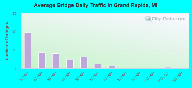
- 6,381,085Total average daily traffic
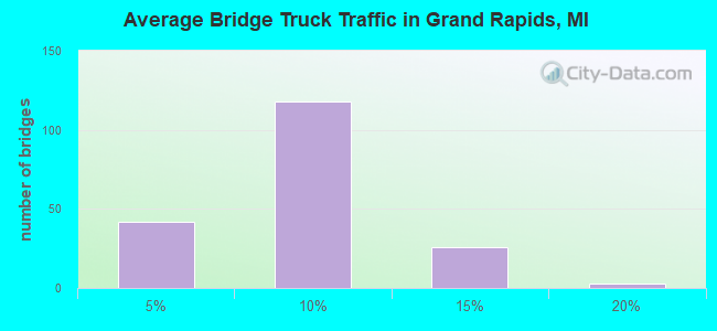
- 408,489Total average daily truck traffic
- National Bridge Inventory (NBI) Registered Bridges for Grand Rapids
- No street view available for this location
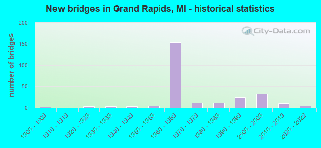
- New bridges - historical statistics
- 1Before 1900
- 21900-1909
- 41920-1929
- 31930-1939
- 41940-1949
- 51950-1959
- 1531960-1969
- 121970-1979
- 121980-1989
- 251990-1999
- 332000-2009
- 102010-2019
- 52020-2022
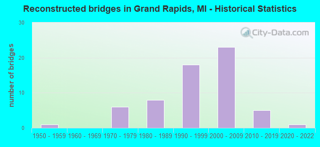
- Reconstructed bridges - Historical Statistics
- 11950-1959
- 01960-1969
- 61970-1979
- 81980-1989
- 181990-1999
- 232000-2009
- 52010-2019
- 12020-2022
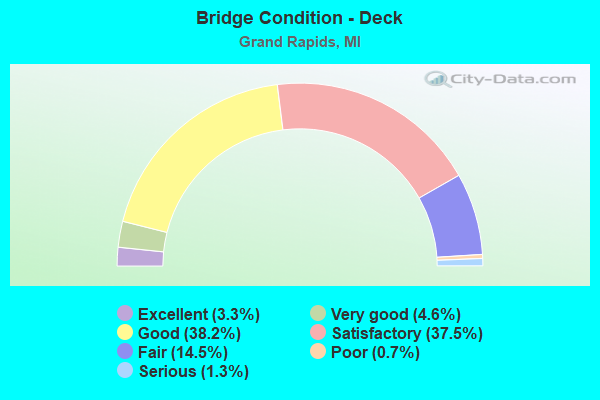
- Bridge Condition - Deck
- 3.3%Excellent
- 4.6%Very good
- 38.2%Good
- 37.5%Satisfactory
- 14.5%Fair
- 0.7%Poor
- 1.3%Serious
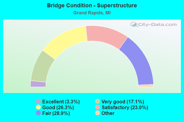
- Bridge Condition - Superstructure
- 3.3%Excellent
- 17.1%Very good
- 26.3%Good
- 23.0%Satisfactory
- 28.9%Fair
- 1.3%Poor
- 0.7%Serious
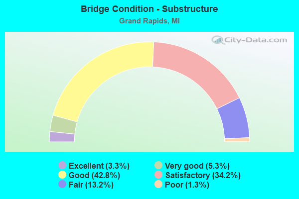
- Bridge Condition - Substructure
- 3.3%Excellent
- 5.3%Very good
- 42.8%Good
- 34.2%Satisfactory
- 13.2%Fair
- 1.3%Poor
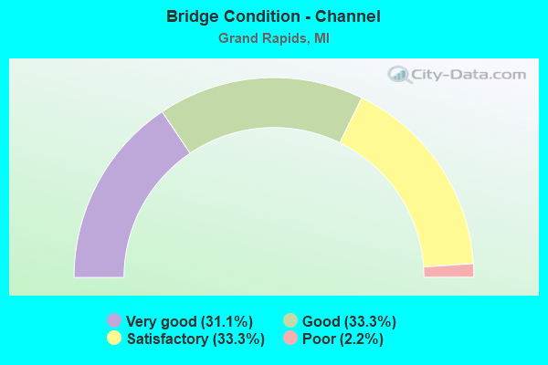
- Bridge Condition - Channel
- 31.1%Very good
- 33.3%Good
- 33.3%Satisfactory
- 2.2%Poor
Find on map >> Show street view
Structure Number: 4771, Location: IN GRAND RAPIDS (Lat: 42.972469, Lng: -85.653578), Route carried "on" structure: Interstate 196, Year Built: 1964, Year Reconstructed: 2006, Status: Open, Structure Length: 7.50m (24.61ft), Average Daily Traffic: 31,051 (year 2007), Truck Traffic: 9%, Average Future Daily Traffic: 45,000 (year 2025), Design Load: HS 20+Mod, Features Intersected: GRAND RAPIDS EASTERN RR
Minimum Vertical Clearance: 30.48m (100.00ft), Kilometerpoint: 17.803, Lanes on structure: 3, Base Highway Network: Yes (Inventory Route: 40, Subroute: 5), Owner: State Highway Agency, Approaching Roadway Width: 22.1m (72.5ft), Skew: 14 degrees, Material/Design: Steel continuous, Design/Construction: Stringer/Multi-beam, Number Of Spans In Main Unit: 3, Length of Maximum Span: 32.3m (106.0ft), Curb-To-Curb Width: 22.3m (73.2ft), Out-to-Out Width: 22.3m (73.2ft)
Condition: Deck: Satisfactory, Superstructure: Very good, Substructure: Good, Operating Rating: 87.8 metric tons, Method Used To Determine Operating Rating: Load Factor (LF), Inventory Rating: 52.6 metric tons, Method Used To Determine Inventory Rating: Load Factor (LF), Structural Evaluation: Better than present minimum criteria, Deck Geometry: Superior to present desirable criteria, Approach Roadway Alignment: Equal to present desirable criteria, Length Of Structure Improvement: 7.50m (24.61ft), Designated Inspection Frequency: Every 24 months, Inspection Date: September 2021, Bridge Improvement Cost: $729,000, Roadway Improvement Cost: $10,000, Total Project Cost: $114,000, Deck Structure Type: Concrete Cast-file-Place, Wearing Surface/Protective System: Wearing Surface: Monolithic Concrete, Deck Protection: Epoxy Coated Reinforcing
Find on map >> Show street view
Structure Number: 4772, Location: IN GRAND RAPIDS (Lat: 42.972592, Lng: -85.653917), Route carried "on" structure: Interstate 196, Year Built: 1964, Year Reconstructed: 2006, Status: Open, Structure Length: 7.50m (24.61ft), Average Daily Traffic: 31,051 (year 2007), Truck Traffic: 9%, Average Future Daily Traffic: 44,500 (year 2022), Design Load: HS 20+Mod, Features Intersected: GRAND RAPIDS EASTERN RR
Minimum Vertical Clearance: 30.48m (100.00ft), Kilometerpoint: 17.897, Lanes on structure: 3, Base Highway Network: Yes (Inventory Route: 40, Subroute: 9), Owner: State Highway Agency, Approaching Roadway Width: 21.3m (69.9ft), Skew: 14 degrees, Material/Design: Steel continuous, Design/Construction: Stringer/Multi-beam, Number Of Spans In Main Unit: 3, Length of Maximum Span: 32.3m (106.0ft), Curb-To-Curb Width: 23.7m (77.8ft), Out-to-Out Width: 24.6m (80.7ft)
Condition: Deck: Satisfactory, Superstructure: Very good, Substructure: Good, Operating Rating: 88.3 metric tons, Method Used To Determine Operating Rating: Load Factor (LF), Inventory Rating: 52.9 metric tons, Method Used To Determine Inventory Rating: Load Factor (LF), Structural Evaluation: Better than present minimum criteria, Deck Geometry: Superior to present desirable criteria, Approach Roadway Alignment: Equal to present desirable criteria, Length Of Structure Improvement: 7.50m (24.61ft), Designated Inspection Frequency: Every 24 months, Inspection Date: September 2021, Bridge Improvement Cost: $728,000, Roadway Improvement Cost: $10,000, Total Project Cost: $113,000, Deck Structure Type: Concrete Cast-file-Place, Wearing Surface/Protective System: Wearing Surface: Monolithic Concrete, Deck Protection: Epoxy Coated Reinforcing
Find on map >> Show street view
Structure Number: 4773, Location: IN GRAND RAPIDS (Lat: 42.971944, Lng: -85.671278), Route carried "on" structure: Interstate 196, Year Built: 1964, Status: Open, Structure Length: 1.34m (4.40ft), Average Daily Traffic: 69,092 (year 2007), Truck Traffic: 7%, Average Future Daily Traffic: 83,259 (year 2018), Design Load: HS 20+Mod, Features Intersected: GTW RR (ABN)
Minimum Vertical Clearance: 30.48m (100.00ft), Kilometerpoint: 16.311, Lanes on structure: 7, Base Highway Network: Yes (Inventory Route: 40, Subroute: 5), Owner: State Highway Agency, Approaching Roadway Width: 12.8m (42.0ft), Skew: 1 degrees, Material/Design: Prestressed concrete, Design/Construction: Stringer/Multi-beam, Number Of Spans In Main Unit: 1, Length of Maximum Span: 13.4m (44.0ft), Curb-To-Curb Width: 36.9m (121.1ft), Out-to-Out Width: 59.7m (195.9ft)
Condition: Deck: Good, Superstructure: Good, Substructure: Good, Operating Rating: 68.7 metric tons, Method Used To Determine Operating Rating: Load Factor (LF) rating reported by rating factor (RF) method using MS18 loading, Inventory Rating: 41.1 metric tons, Method Used To Determine Inventory Rating: Load Factor (LF) rating reported by rating factor (RF) method using MS18 loading, Structural Evaluation: Better than present minimum criteria, Deck Geometry: Superior to present desirable criteria, Approach Roadway Alignment: Equal to present desirable criteria, Designated Inspection Frequency: Every 24 months, Inspection Date: March 2021
Find on map >> Show street view
Structure Number: 4774, Location: IN GRAND RAPIDS (Lat: 42.973150, Lng: -85.679744), Route carried "on" structure: Interstate 196, Year Built: 1964, Year Reconstructed: 2002, Status: Open, Structure Length: 5.39m (17.68ft), Average Daily Traffic: 34,546 (year 2007), Truck Traffic: 7%, Average Future Daily Traffic: 45,010 (year 2018), Design Load: HS 20+Mod, Features Intersected: BROADWAY AVE & TURNER AV
Minimum Vertical Clearance: 30.48m (100.00ft), Kilometerpoint: 15.621, Lanes on structure: 2, Lanes under structure: 6, Base Highway Network: Yes (Inventory Route: 40, Subroute: 5), Owner: State Highway Agency, Approaching Roadway Width: 15.5m (50.9ft), Material/Design: Prestressed concrete, Design/Construction: Stringer/Multi-beam, Number Of Spans In Main Unit: 4, Length of Maximum Span: 17.1m (56.1ft), Curb-To-Curb Width: 20.1m (65.9ft), Out-to-Out Width: 21.1m (69.2ft)
Condition: Deck: Good, Superstructure: Satisfactory, Substructure: Satisfactory, Operating Rating: 54.1 metric tons, Method Used To Determine Operating Rating: Load Factor (LF) rating reported by rating factor (RF) method using MS18 loading, Inventory Rating: 32.4 metric tons, Method Used To Determine Inventory Rating: Load Factor (LF) rating reported by rating factor (RF) method using MS18 loading, Structural Evaluation: Equal to present minimum criteria, Deck Geometry: Superior to present desirable criteria, Underclear: High priority of corrective action, Approach Roadway Alignment: Equal to present minimum criteria, Designated Inspection Frequency: Every 24 months, Inspection Date: September 2020, Deck Structure Type: Concrete Cast-file-Place, Wearing Surface/Protective System: Wearing Surface: Monolithic Concrete
Find on map >> Show street view
Structure Number: 4775, Location: IN GRAND RAPIDS (I-196 WB (Lat: 42.972947, Lng: -85.678233), Route carried "on" structure: Interstate 296, Year Built: 1963, Status: Open, Structure Length: 4.02m (13.19ft), Average Daily Traffic: 47,806 (year 2007), Truck Traffic: 11%, Average Future Daily Traffic: 57,022 (year 2018), Design Load: HS 20+Mod, Features Intersected: I-196 EB, M-21
Minimum Vertical Clearance: 30.48m (100.00ft), Kilometerpoint: 23.451, Lanes on structure: 4, Lanes under structure: 2, Base Highway Network: Yes (Inventory Route: 41, Subroute: 3), Owner: State Highway Agency, Approaching Roadway Width: 15.2m (49.9ft), Material/Design: Prestressed concrete, Design/Construction: Stringer/Multi-beam, Number Of Spans In Main Unit: 3, Length of Maximum Span: 15.2m (49.9ft), Curb-To-Curb Width: 17.5m (57.4ft), Out-to-Out Width: 18.2m (59.7ft)
Condition: Deck: Satisfactory, Superstructure: Satisfactory, Substructure: Fair, Operating Rating: 54.8 metric tons, Method Used To Determine Operating Rating: Load Factor (LF) rating reported by rating factor (RF) method using MS18 loading, Inventory Rating: 32.7 metric tons, Method Used To Determine Inventory Rating: Load Factor (LF) rating reported by rating factor (RF) method using MS18 loading, Structural Evaluation: Somewhat better than minimum adequacy, Deck Geometry: Meets minimum limits, Underclear: Equal to present minimum criteria, Approach Roadway Alignment: Better than present minimum criteria, Designated Inspection Frequency: Every 23 months, Inspection Date: March 2021, Deck Structure Type: Concrete Cast-file-Place, Wearing Surface/Protective System: Wearing Surface: Monolithic Concrete
Find on map >> Show street view
Structure Number: 4776, Location: IN GRAND RAPIDS (Lat: 42.972786, Lng: -85.677225), Route carried "on" structure: Interstate 296, Year Built: 1963, Status: Open, Structure Length: 3.78m (12.40ft), Average Daily Traffic: 47,806 (year 2007), Truck Traffic: 11%, Average Future Daily Traffic: 57,022 (year 2018), Design Load: HS 20+Mod, Features Intersected: I-196 EB, M-21
Minimum Vertical Clearance: 30.48m (100.00ft), Kilometerpoint: 23.443, Lanes on structure: 2, Lanes under structure: 2, Base Highway Network: Yes (Inventory Route: 41, Subroute: 7), Owner: State Highway Agency, Approaching Roadway Width: 12.8m (42.0ft), Material/Design: Prestressed concrete, Design/Construction: Stringer/Multi-beam, Number Of Spans In Main Unit: 3, Length of Maximum Span: 15.2m (49.9ft), Curb-To-Curb Width: 15.8m (51.8ft), Out-to-Out Width: 16.5m (54.1ft)
Condition: Deck: Fair, Superstructure: Fair, Substructure: Satisfactory, Operating Rating: 58.6 metric tons, Method Used To Determine Operating Rating: Load Factor (LF) rating reported by rating factor (RF) method using MS18 loading, Inventory Rating: 31.1 metric tons, Method Used To Determine Inventory Rating: Load Factor (LF) rating reported by rating factor (RF) method using MS18 loading, Structural Evaluation: Somewhat better than minimum adequacy, Deck Geometry: Superior to present desirable criteria, Underclear: High priority of corrective action, Approach Roadway Alignment: Better than present minimum criteria, Length Of Structure Improvement: 3.78m (12.40ft), Designated Inspection Frequency: Every 24 months, Inspection Date: September 2021, Bridge Improvement Cost: $25,000, Roadway Improvement Cost: $3,000, Total Project Cost: $30,000, Deck Structure Type: Concrete Cast-file-Place, Wearing Surface/Protective System: Wearing Surface: Monolithic Concrete
Find on map >> Show street view
Structure Number: 4777, Location: IN GRAND RAPIDS (I-196 NB (Lat: 42.974831, Lng: -85.677753), Route carried "on" structure: Interstate 296, Year Built: 1963, Status: Open, Structure Length: 11.28m (37.01ft), Average Daily Traffic: 47,806 (year 2007), Truck Traffic: 11%, Average Future Daily Traffic: 57,022 (year 2018), Design Load: HS 20+Mod, Features Intersected: I-196 WB TO I-196,296 NB
Minimum Vertical Clearance: 30.48m (100.00ft), Kilometerpoint: 23.653, Lanes on structure: 4, Lanes under structure: 3, Base Highway Network: Yes (Inventory Route: 41, Subroute: 7), Owner: State Highway Agency, Approaching Roadway Width: 10.9m (35.8ft), Skew: 29 degrees, Material/Design: Steel, Design/Construction: Stringer/Multi-beam, Number Of Spans In Main Unit: 4, Length of Maximum Span: 39.0m (128.0ft), Curb or Sidewalk Widths: Left: 0.4m (1.3ft), Right: 0.0m, Curb-To-Curb Width: 23.8m (78.1ft), Out-to-Out Width: 25.0m (82.0ft)
Condition: Deck: Fair, Superstructure: Fair, Substructure: Satisfactory, Operating Rating: 64.8 metric tons, Method Used To Determine Operating Rating: Load Factor (LF) rating reported by rating factor (RF) method using MS18 loading, Inventory Rating: 38.9 metric tons, Method Used To Determine Inventory Rating: Load Factor (LF) rating reported by rating factor (RF) method using MS18 loading, Structural Evaluation: Somewhat better than minimum adequacy, Deck Geometry: Superior to present desirable criteria, Underclear: Somewhat better than minimum adequacy, Approach Roadway Alignment: Equal to present minimum criteria, Designated Inspection Frequency: Every 24 months, Inspection Date: September 2021, Bridge Improvement Cost: $524,000, Deck Structure Type: Concrete Cast-file-Place, Wearing Surface/Protective System: Wearing Surface: Latex Concrete
Find on map >> Show street view
Structure Number: 4778, Location: IN GRAND RAPIDS (6TH ST) (Lat: 42.976903, Lng: -85.677978), Route carried "on" structure: Interstate 296, Year Built: 1963, Status: Open, Structure Length: 4.36m (14.30ft), Average Daily Traffic: 50,972 (year 2007), Truck Traffic: 6%, Average Future Daily Traffic: 63,403 (year 2018), Design Load: HS 20+Mod, Features Intersected: 6TH AVE
Minimum Vertical Clearance: 30.48m (100.00ft), Kilometerpoint: 23.911, Lanes on structure: 5, Lanes under structure: 5, Base Highway Network: Yes (Inventory Route: 41, Subroute: 7), Owner: State Highway Agency, Approaching Roadway Width: 18.2m (59.7ft), Material/Design: Prestressed concrete, Design/Construction: Stringer/Multi-beam, Number Of Spans In Main Unit: 3, Length of Maximum Span: 20.4m (66.9ft), Curb-To-Curb Width: 20.4m (66.9ft), Out-to-Out Width: 21.1m (69.2ft)
Condition: Deck: Fair, Superstructure: Fair, Substructure: Fair, Operating Rating: 64.5 metric tons, Method Used To Determine Operating Rating: Load Factor (LF) rating reported by rating factor (RF) method using MS18 loading, Inventory Rating: 38.6 metric tons, Method Used To Determine Inventory Rating: Load Factor (LF) rating reported by rating factor (RF) method using MS18 loading, Structural Evaluation: Somewhat better than minimum adequacy, Deck Geometry: High priority of corrective action, Underclear: Meets minimum limits, Approach Roadway Alignment: Better than present minimum criteria, Designated Inspection Frequency: Every 24 months, Inspection Date: July 2020, Deck Structure Type: Concrete Cast-file-Place, Wearing Surface/Protective System: Wearing Surface: Monolithic Concrete
Find on map >> Show street view
Structure Number: 4779, Location: IN GRAND RAPIDS (6TH ST) (Lat: 42.976875, Lng: -85.677497), Route carried "on" structure: Interstate 296, Year Built: 1963, Status: Open, Structure Length: 4.23m (13.88ft), Average Daily Traffic: 50,972 (year 2007), Truck Traffic: 6%, Average Future Daily Traffic: 63,403 (year 2018), Design Load: HS 20+Mod, Features Intersected: 6TH AVE
Minimum Vertical Clearance: 30.48m (100.00ft), Kilometerpoint: 23.892, Lanes on structure: 5, Lanes under structure: 5, Base Highway Network: Yes (Inventory Route: 41, Subroute: 3), Owner: State Highway Agency, Approaching Roadway Width: 18.2m (59.7ft), Material/Design: Prestressed concrete, Design/Construction: Stringer/Multi-beam, Number Of Spans In Main Unit: 3, Length of Maximum Span: 20.4m (66.9ft), Curb-To-Curb Width: 20.4m (66.9ft), Out-to-Out Width: 21.2m (69.6ft)
Condition: Deck: Satisfactory, Superstructure: Fair, Substructure: Satisfactory, Operating Rating: 67.1 metric tons, Method Used To Determine Operating Rating: Load Factor (LF) rating reported by rating factor (RF) method using MS18 loading, Inventory Rating: 40.2 metric tons, Method Used To Determine Inventory Rating: Load Factor (LF) rating reported by rating factor (RF) method using MS18 loading, Structural Evaluation: Somewhat better than minimum adequacy, Deck Geometry: High priority of corrective action, Underclear: Meets minimum limits, Approach Roadway Alignment: Better than present minimum criteria, Designated Inspection Frequency: Every 24 months, Inspection Date: July 2020, Deck Structure Type: Concrete Cast-file-Place, Wearing Surface/Protective System: Wearing Surface: Monolithic Concrete
Find on map >> Show street view
Structure Number: 478, Location: IN GRAND RAPIDS (I-196EB) (Lat: 42.972728, Lng: -85.676081), Route carried "on" structure: City street , Year Built: 1964, Year Reconstructed: 2008, Status: Open, Structure Length: 5.12m (16.80ft), Average Daily Traffic: 2,900 (year 2008), Truck Traffic: 2%, Average Future Daily Traffic: 3,200 (year 2028), Design Load: HS 20+Mod, Features Intersected: I-196 EB, Facility Carried by Structure: SCRIBNER AVE
Minimum Vertical Clearance: 30.48m (100.00ft), Kilometerpoint: 0.718, Lanes on structure: 2, Lanes under structure: 4, Owner: State Highway Agency, Approaching Roadway Width: 12.8m (42.0ft), Skew: 9 degrees, Material/Design: Steel, Design/Construction: Stringer/Multi-beam, Number Of Spans In Main Unit: 3, Length of Maximum Span: 28.0m (91.9ft), Curb or Sidewalk Widths: Left: 1.5m (4.9ft), Right: 1.5m (4.9ft), Curb-To-Curb Width: 12.2m (40.0ft), Out-to-Out Width: 15.9m (52.2ft)
Condition: Deck: Satisfactory, Superstructure: Fair, Substructure: Satisfactory, Operating Rating: 76.1 metric tons, Method Used To Determine Operating Rating: Load Factor (LF) rating reported by rating factor (RF) method using MS18 loading, Inventory Rating: 45.4 metric tons, Method Used To Determine Inventory Rating: Load Factor (LF) rating reported by rating factor (RF) method using MS18 loading, Structural Evaluation: Somewhat better than minimum adequacy, Deck Geometry: Equal to present minimum criteria, Underclear: High priority of corrective action, Approach Roadway Alignment: Equal to present desirable criteria, Designated Inspection Frequency: Every 24 months, Inspection Date: April 2021, Deck Structure Type: Concrete Cast-file-Place, Wearing Surface/Protective System: Wearing Surface: Latex Concrete
Find on map >> Show street view
Structure Number: 4781, Location: IN GRAND RAPIDS (Lat: 42.972039, Lng: -85.672322), Route carried "on" structure: Interstate 196, Year Built: 1964, Year Reconstructed: 2004, Status: Open, Structure Length: 5.44m (17.85ft), Average Daily Traffic: 34,546 (year 2007), Truck Traffic: 7%, Average Future Daily Traffic: 45,010 (year 2018), Design Load: HS 20+Mod, Features Intersected: MONROE
Minimum Vertical Clearance: 30.48m (100.00ft), Kilometerpoint: 16.257, Lanes on structure: 4, Lanes under structure: 5, Base Highway Network: Yes (Inventory Route: 40, Subroute: 5), Owner: State Highway Agency, Approaching Roadway Width: 18.2m (59.7ft), Skew: 1 degrees, Material/Design: Steel, Design/Construction: Stringer/Multi-beam, Number Of Spans In Main Unit: 3, Length of Maximum Span: 21.9m (71.9ft), Curb or Sidewalk Widths: Left: 0.1m (0.3ft), Right: 0.7m (2.3ft), Curb-To-Curb Width: 16.8m (55.1ft), Out-to-Out Width: 17.8m (58.4ft)
Condition: Deck: Good, Superstructure: Satisfactory, Substructure: Good, Operating Rating: 58.3 metric tons, Method Used To Determine Operating Rating: Load Factor (LF) rating reported by rating factor (RF) method using MS18 loading, Inventory Rating: 35.0 metric tons, Method Used To Determine Inventory Rating: Load Factor (LF) rating reported by rating factor (RF) method using MS18 loading, Structural Evaluation: Equal to present minimum criteria, Deck Geometry: High priority of replacement, Underclear: Meets minimum limits, Approach Roadway Alignment: Equal to present desirable criteria, Designated Inspection Frequency: Every 24 months, Inspection Date: April 2021, Deck Structure Type: Concrete Cast-file-Place, Wearing Surface/Protective System: Wearing Surface: Monolithic Concrete, Deck Protection: Epoxy Coated Reinforcing
Find on map >> Show street view
Structure Number: 4782, Location: IN GRAND RAPIDS (Lat: 42.971725, Lng: -85.670036), Route carried "on" structure: Interstate 196, Year Built: 1963, Year Reconstructed: 2006, Status: Open, Structure Length: 5.83m (19.13ft), Average Daily Traffic: 34,546 (year 2007), Truck Traffic: 9%, Average Future Daily Traffic: 47,000 (year 2022), Design Load: HS 20+Mod, Features Intersected: OTTAWA AVE & RAMP A
Minimum Vertical Clearance: 30.48m (100.00ft), Kilometerpoint: 16.445, Lanes on structure: 3, Lanes under structure: 3, Base Highway Network: Yes (Inventory Route: 40, Subroute: 5), Owner: State Highway Agency, Approaching Roadway Width: 17.9m (58.7ft), Skew: 11 degrees, Material/Design: Steel continuous, Design/Construction: Stringer/Multi-beam, Number Of Spans In Main Unit: 3, Length of Maximum Span: 23.4m (76.8ft), Curb-To-Curb Width: 17.7m (58.1ft), Out-to-Out Width: 18.7m (61.4ft)
Condition: Deck: Satisfactory, Superstructure: Very good, Substructure: Satisfactory, Operating Rating: 93.9 metric tons, Method Used To Determine Operating Rating: Load Factor (LF), Inventory Rating: 56.2 metric tons, Method Used To Determine Inventory Rating: Load Factor (LF), Structural Evaluation: Equal to present minimum criteria, Deck Geometry: Better than present minimum criteria, Underclear: High priority of corrective action, Approach Roadway Alignment: Equal to present desirable criteria, Designated Inspection Frequency: Every 24 months, Inspection Date: April 2021, Bridge Improvement Cost: $162,000, Deck Structure Type: Concrete Cast-file-Place, Wearing Surface/Protective System: Wearing Surface: Monolithic Concrete, Deck Protection: Epoxy Coated Reinforcing
Find on map >> Show street view
Structure Number: 4783, Location: IN GRAND RAPIDS (Lat: 42.971889, Lng: -85.670033), Route carried "on" structure: Interstate 196, Year Built: 1963, Year Reconstructed: 2006, Status: Open, Structure Length: 5.90m (19.36ft), Average Daily Traffic: 34,546 (year 2007), Truck Traffic: 9%, Average Future Daily Traffic: 47,000 (year 2022), Design Load: HS 20+Mod, Features Intersected: OTTAWA AVE & RAMP A
Minimum Vertical Clearance: 30.48m (100.00ft), Kilometerpoint: 16.567, Lanes on structure: 2, Lanes under structure: 3, Base Highway Network: Yes (Inventory Route: 40, Subroute: 9), Owner: State Highway Agency, Approaching Roadway Width: 17.9m (58.7ft), Skew: 11 degrees, Material/Design: Steel continuous, Design/Construction: Stringer/Multi-beam, Number Of Spans In Main Unit: 3, Length of Maximum Span: 23.7m (77.8ft), Curb-To-Curb Width: 17.7m (58.1ft), Out-to-Out Width: 18.7m (61.4ft)
Condition: Deck: Satisfactory, Superstructure: Good, Substructure: Good, Operating Rating: 93.4 metric tons, Method Used To Determine Operating Rating: Load Factor (LF), Inventory Rating: 55.9 metric tons, Method Used To Determine Inventory Rating: Load Factor (LF), Structural Evaluation: Better than present minimum criteria, Deck Geometry: Superior to present desirable criteria, Underclear: High priority of corrective action, Approach Roadway Alignment: Equal to present desirable criteria, Designated Inspection Frequency: Every 24 months, Inspection Date: April 2021, Bridge Improvement Cost: $925,000, Deck Structure Type: Concrete Cast-file-Place, Wearing Surface/Protective System: Wearing Surface: Monolithic Concrete, Deck Protection: Epoxy Coated Reinforcing
Find on map >> Show street view
Structure Number: 4784, Location: IN GRAND RAPIDS (Lat: 42.972153, Lng: -85.670036), Route carried "on" structure: Ramp Interstate 196, Year Built: 1963, Year Reconstructed: 2005, Status: Open, Structure Length: 4.86m (15.94ft), Average Daily Traffic: 7,850 (year 1999), Truck Traffic: 8%, Average Future Daily Traffic: 9,028 (year 2019), Design Load: HS 20+Mod, Features Intersected: OTTAWA AVE & RAMP A
Minimum Vertical Clearance: 30.48m (100.00ft), Kilometerpoint: 0.089, Lanes on structure: 1, Lanes under structure: 4, Owner: State Highway Agency, Approaching Roadway Width: 9.1m (29.9ft), Material/Design: Steel, Design/Construction: Stringer/Multi-beam, Number Of Spans In Main Unit: 3, Length of Maximum Span: 23.2m (76.1ft), Curb-To-Curb Width: 8.5m (27.9ft), Out-to-Out Width: 9.5m (31.2ft)
Condition: Deck: Good, Superstructure: Good, Substructure: Good, Operating Rating: 93.0 metric tons, Method Used To Determine Operating Rating: Load Factor (LF) rating reported by rating factor (RF) method using MS18 loading, Inventory Rating: 55.7 metric tons, Method Used To Determine Inventory Rating: Load Factor (LF) rating reported by rating factor (RF) method using MS18 loading, Structural Evaluation: Better than present minimum criteria, Deck Geometry: Superior to present desirable criteria, Underclear: Meets minimum limits, Approach Roadway Alignment: Equal to present desirable criteria, Designated Inspection Frequency: Every 24 months, Inspection Date: April 2021, Deck Structure Type: Concrete Cast-file-Place, Wearing Surface/Protective System: Wearing Surface: Monolithic Concrete, Deck Protection: Epoxy Coated Reinforcing
Find on map >> Show street view
Structure Number: 4785, Location: IN GRAND RAPIDS (Lat: 42.971586, Lng: -85.668806), Route carried "on" structure: Interstate 196, Year Built: 1964, Year Reconstructed: 2006, Status: Open, Structure Length: 7.01m (23.00ft), Average Daily Traffic: 34,546 (year 2007), Truck Traffic: 9%, Average Future Daily Traffic: 49,000 (year 2022), Design Load: HS 25 or greater, Features Intersected: US-131BR & IONIA
Minimum Vertical Clearance: 30.48m (100.00ft), Kilometerpoint: 16.548, Lanes on structure: 4, Lanes under structure: 8, Base Highway Network: Yes (Inventory Route: 40, Subroute: 5), Owner: State Highway Agency, Approaching Roadway Width: 19.4m (63.6ft), Skew: 10 degrees, Material/Design: Steel continuous, Design/Construction: Stringer/Multi-beam, Number Of Spans In Main Unit: 4, Length of Maximum Span: 22.5m (73.8ft), Curb-To-Curb Width: 21.3m (69.9ft), Out-to-Out Width: 22.3m (73.2ft)
Condition: Deck: Good, Superstructure: Very good, Substructure: Satisfactory, Operating Rating: 73.2 metric tons, Method Used To Determine Operating Rating: Load Factor (LF) rating reported by rating factor (RF) method using MS18 loading, Inventory Rating: 43.7 metric tons, Method Used To Determine Inventory Rating: Load Factor (LF) rating reported by rating factor (RF) method using MS18 loading, Structural Evaluation: Equal to present minimum criteria, Deck Geometry: Better than present minimum criteria, Underclear: Somewhat better than minimum adequacy, Approach Roadway Alignment: Equal to present desirable criteria, Designated Inspection Frequency: Every 24 months, Inspection Date: April 2021, Deck Structure Type: Concrete Cast-file-Place, Wearing Surface/Protective System: Wearing Surface: Monolithic Concrete, Deck Protection: Epoxy Coated Reinforcing
Find on map >> Show street view
Structure Number: 4786, Location: IN GRAND RAPIDS DIVISION (Lat: 42.971783, Lng: -85.668828), Route carried "on" structure: Interstate 196, Year Built: 1964, Year Reconstructed: 2006, Status: Open, Structure Length: 7.22m (23.69ft), Average Daily Traffic: 34,546 (year 2007), Truck Traffic: 9%, Average Future Daily Traffic: 47,000 (year 2022), Design Load: HS 25 or greater, Features Intersected: US-131BR & IONIA
Minimum Vertical Clearance: 30.48m (100.00ft), Kilometerpoint: 16.667, Lanes on structure: 2, Lanes under structure: 8, Base Highway Network: Yes (Inventory Route: 40, Subroute: 9), Owner: State Highway Agency, Approaching Roadway Width: 14.8m (48.6ft), Skew: 10 degrees, Material/Design: Steel continuous, Design/Construction: Stringer/Multi-beam, Number Of Spans In Main Unit: 4, Length of Maximum Span: 22.5m (73.8ft), Curb-To-Curb Width: 17.7m (58.1ft), Out-to-Out Width: 18.7m (61.4ft)
Condition: Deck: Good, Superstructure: Very good, Substructure: Good, Operating Rating: 97.2 metric tons, Method Used To Determine Operating Rating: Load Factor (LF) rating reported by rating factor (RF) method using MS18 loading, Inventory Rating: 61.9 metric tons, Method Used To Determine Inventory Rating: Load Factor (LF) rating reported by rating factor (RF) method using MS18 loading, Structural Evaluation: Better than present minimum criteria, Deck Geometry: Superior to present desirable criteria, Underclear: Somewhat better than minimum adequacy, Approach Roadway Alignment: Equal to present desirable criteria, Length Of Structure Improvement: 7.23m (23.72ft), Designated Inspection Frequency: Every 24 months, Inspection Date: April 2021, Bridge Improvement Cost: $1,125,000, Roadway Improvement Cost: $69,000, Total Project Cost: $817,000, Deck Structure Type: Concrete Cast-file-Place, Wearing Surface/Protective System: Wearing Surface: Monolithic Concrete, Deck Protection: Epoxy Coated Reinforcing
Find on map >> Show street view
Structure Number: 4787, Location: IN GRAND RAPIDS DIVISION (Lat: 42.972989, Lng: -85.668867), Route carried "on" structure: Ramp Interstate 196, Year Built: 1964, Year Reconstructed: 2004, Status: Open, Structure Length: 5.48m (17.98ft), Average Daily Traffic: 5,800 (year 1999), Truck Traffic: 8%, Average Future Daily Traffic: 6,670 (year 2019), Design Load: HS 20+Mod, Features Intersected: US-131BR & IONIA
Minimum Vertical Clearance: 30.48m (100.00ft), Kilometerpoint: 0.208, Lanes on structure: 1, Lanes under structure: 4, Owner: State Highway Agency, Approaching Roadway Width: 9.1m (29.9ft), Skew: 9 degrees, Material/Design: Steel, Design/Construction: Stringer/Multi-beam, Number Of Spans In Main Unit: 3, Length of Maximum Span: 26.2m (86.0ft), Curb-To-Curb Width: 8.4m (27.6ft), Out-to-Out Width: 9.4m (30.8ft)
Condition: Deck: Good, Superstructure: Very good, Substructure: Satisfactory, Operating Rating: 88.8 metric tons, Method Used To Determine Operating Rating: Load Factor (LF) rating reported by rating factor (RF) method using MS18 loading, Inventory Rating: 53.1 metric tons, Method Used To Determine Inventory Rating: Load Factor (LF) rating reported by rating factor (RF) method using MS18 loading, Structural Evaluation: Equal to present minimum criteria, Deck Geometry: Superior to present desirable criteria, Underclear: Somewhat better than minimum adequacy, Approach Roadway Alignment: Equal to present desirable criteria, Designated Inspection Frequency: Every 24 months, Inspection Date: September 2021, Deck Structure Type: Concrete Cast-file-Place, Wearing Surface/Protective System: Wearing Surface: Monolithic Concrete, Deck Protection: Epoxy Coated Reinforcing
Find on map >> Show street view
Structure Number: 4788, Location: IN GRAND RAPIDS (Lat: 42.971542, Lng: -85.664392), Route carried "on" structure: City street , Year Built: 2009, Status: Open, Structure Length: 4.66m (15.29ft), Average Daily Traffic: 2,750 (year 1988), Truck Traffic: 1%, Average Future Daily Traffic: 3,500 (year 2030), Design Load: Greater than HL93, Features Intersected: I-196 & M-21, Facility Carried by Structure: COIT AVE
Minimum Vertical Clearance: 30.48m (100.00ft), Kilometerpoint: 0.124, Lanes on structure: 2, Lanes under structure: 8, Owner: State Highway Agency, Approaching Roadway Width: 8.5m (27.9ft), Material/Design: Prestressed concrete, Design/Construction: Box Beam or Girders - Single/Spread, Number Of Spans In Main Unit: 2, Length of Maximum Span: 22.6m (74.1ft), Curb or Sidewalk Widths: Left: 3.7m (12.1ft), Right: 3.7m (12.1ft), Curb-To-Curb Width: 8.5m (27.9ft), Out-to-Out Width: 16.6m (54.5ft)
Condition: Deck: Satisfactory, Superstructure: Satisfactory, Substructure: Good, Operating Rating: 68.3 metric tons, Method Used To Determine Operating Rating: Load Factor (LF), Inventory Rating: 40.9 metric tons, Method Used To Determine Inventory Rating: Load Factor (LF), Structural Evaluation: Equal to present minimum criteria, Deck Geometry: Meets minimum limits, Underclear: Equal to present minimum criteria, Approach Roadway Alignment: Equal to present desirable criteria, Designated Inspection Frequency: Every 24 months, Inspection Date: March 2021, Deck Structure Type: Concrete Cast-file-Place, Wearing Surface/Protective System: Wearing Surface: Monolithic Concrete, Deck Protection: Epoxy Coated Reinforcing
Find on map >> Show street view
Structure Number: 4789, Location: IN GRAND RAPIDS LAFAYETTE (Lat: 42.971581, Lng: -85.661931), Route carried "on" structure: Interstate 196, Year Built: 2009, Status: Open, Structure Length: 2.02m (6.63ft), Average Daily Traffic: 33,144 (year 2007), Truck Traffic: 8%, Average Future Daily Traffic: 53,000 (year 2030), Design Load: Greater than HL93, Features Intersected: LAFAYETTE AVE
Minimum Vertical Clearance: 30.48m (100.00ft), Kilometerpoint: 17.108, Lanes on structure: 4, Lanes under structure: 4, Base Highway Network: Yes (Inventory Route: 40, Subroute: 5), Owner: State Highway Agency, Approaching Roadway Width: 14.6m (47.9ft), Skew: 10 degrees, Material/Design: Prestressed concrete, Design/Construction: Box Beam or Girders - Single/Spread, Number Of Spans In Main Unit: 1, Length of Maximum Span: 19.3m (63.3ft), Curb or Sidewalk Widths: Left: 0.1m (0.3ft), Right: 0.1m (0.3ft), Curb-To-Curb Width: 21.9m (71.9ft), Out-to-Out Width: 23.0m (75.5ft)
Condition: Deck: Satisfactory, Superstructure: Very good, Substructure: Good, Operating Rating: 69.8 metric tons, Method Used To Determine Operating Rating: Load Factor (LF), Inventory Rating: 41.8 metric tons, Method Used To Determine Inventory Rating: Load Factor (LF), Structural Evaluation: Better than present minimum criteria, Deck Geometry: Better than present minimum criteria, Underclear: Somewhat better than minimum adequacy, Approach Roadway Alignment: Equal to present desirable criteria, Designated Inspection Frequency: Every 24 months, Inspection Date: April 2021, Deck Structure Type: Concrete Cast-file-Place, Wearing Surface/Protective System: Wearing Surface: Monolithic Concrete, Deck Protection: Epoxy Coated Reinforcing
Find on map >> Show street view
Structure Number: 479, Location: IN GRAND RAPIDS LAFAYETTE (Lat: 42.971747, Lng: -85.661933), Route carried "on" structure: Interstate 196, Year Built: 2009, Status: Open, Structure Length: 2.02m (6.63ft), Average Daily Traffic: 33,144 (year 2007), Truck Traffic: 8%, Average Future Daily Traffic: 51,750 (year 2030), Design Load: Greater than HL93, Features Intersected: LAFAYETTE AVE
Minimum Vertical Clearance: 30.48m (100.00ft), Kilometerpoint: 17.229, Lanes on structure: 3, Lanes under structure: 4, Base Highway Network: Yes (Inventory Route: 40, Subroute: 9), Owner: State Highway Agency, Approaching Roadway Width: 14.6m (47.9ft), Skew: 10 degrees, Material/Design: Prestressed concrete, Design/Construction: Box Beam or Girders - Single/Spread, Number Of Spans In Main Unit: 1, Length of Maximum Span: 19.3m (63.3ft), Curb-To-Curb Width: 22.1m (72.5ft), Out-to-Out Width: 23.1m (75.8ft)
Condition: Deck: Good, Superstructure: Good, Substructure: Good, Operating Rating: 69.1 metric tons, Method Used To Determine Operating Rating: Load Factor (LF), Inventory Rating: 41.3 metric tons, Method Used To Determine Inventory Rating: Load Factor (LF), Structural Evaluation: Better than present minimum criteria, Deck Geometry: Superior to present desirable criteria, Underclear: Somewhat better than minimum adequacy, Approach Roadway Alignment: Equal to present desirable criteria, Designated Inspection Frequency: Every 24 months, Inspection Date: April 2021, Deck Structure Type: Concrete Cast-file-Place, Wearing Surface/Protective System: Wearing Surface: Monolithic Concrete, Deck Protection: Epoxy Coated Reinforcing
Find on map >> Show street view
Structure Number: 4791, Location: IN GRAND RAPIDS (Lat: 42.971722, Lng: -85.656994), Route carried "on" structure: City street 2001, Year Built: 2008, Status: Open, Structure Length: 4.04m (13.25ft), Average Daily Traffic: 13,800 (year 2007), Truck Traffic: 6%, Average Future Daily Traffic: 22,950 (year 2027), Design Load: Greater than HL93, Features Intersected: I-196, Facility Carried by Structure: COLLEGE AVE
Minimum Vertical Clearance: 30.48m (100.00ft), Kilometerpoint: 2.770, Lanes on structure: 6, Lanes under structure: 4, Owner: State Highway Agency, Approaching Roadway Width: 21.3m (69.9ft), Material/Design: Prestressed concrete, Design/Construction: Box Beam or Girders - Single/Spread, Number Of Spans In Main Unit: 2, Length of Maximum Span: 19.5m (64.0ft), Curb or Sidewalk Widths: Left: 3.0m (9.8ft), Right: 3.0m (9.8ft), Curb-To-Curb Width: 21.3m (69.9ft), Out-to-Out Width: 28.5m (93.5ft)
Condition: Deck: Good, Superstructure: Satisfactory, Substructure: Good, Operating Rating: 58.3 metric tons, Method Used To Determine Operating Rating: Load and Resistance Factor Rating (LRFR) rating reported by rating factor(RF) method using HL-93 loadings, Inventory Rating: 45.0 metric tons, Method Used To Determine Inventory Rating: Load and Resistance Factor Rating (LRFR) rating reported by rating factor(RF) method using HL-93 loadings, Structural Evaluation: Equal to present minimum criteria, Deck Geometry: High priority of replacement, Underclear: Somewhat better than minimum adequacy, Approach Roadway Alignment: Equal to present desirable criteria, Designated Inspection Frequency: Every 24 months, Inspection Date: April 2021, Deck Structure Type: Concrete Cast-file-Place, Wearing Surface/Protective System: Wearing Surface: Monolithic Concrete, Deck Protection: Epoxy Coated Reinforcing
Find on map >> Show street view
Structure Number: 4792, Location: IN GRAND RAPIDS (Lat: 42.973303, Lng: -85.649625), Route carried "on" structure: City street , Year Built: 2009, Status: Open, Structure Length: 4.69m (15.39ft), Average Daily Traffic: 2,000 (year 1988), Truck Traffic: 3%, Average Future Daily Traffic: 2,300 (year 2008), Design Load: Greater than HL93, Features Intersected: I-196 & M-21, Facility Carried by Structure: EASTERN AVE
Minimum Vertical Clearance: 30.48m (100.00ft), Kilometerpoint: 0.916, Lanes on structure: 2, Lanes under structure: 8, Owner: State Highway Agency, Approaching Roadway Width: 11.3m (37.1ft), Material/Design: Prestressed concrete, Design/Construction: Box Beam or Girders - Single/Spread, Number Of Spans In Main Unit: 2, Length of Maximum Span: 22.5m (73.8ft), Curb or Sidewalk Widths: Left: 3.0m (9.8ft), Right: 3.0m (9.8ft), Curb-To-Curb Width: 11.3m (37.1ft), Out-to-Out Width: 18.4m (60.4ft)
Condition: Deck: Good, Superstructure: Satisfactory, Substructure: Good, Operating Rating: 87.0 metric tons, Method Used To Determine Operating Rating: Load Factor (LF), Inventory Rating: 41.3 metric tons, Method Used To Determine Inventory Rating: Load Factor (LF), Structural Evaluation: Equal to present minimum criteria, Deck Geometry: Equal to present minimum criteria, Underclear: Meets minimum limits, Approach Roadway Alignment: Equal to present desirable criteria, Designated Inspection Frequency: Every 24 months, Inspection Date: April 2021, Deck Structure Type: Concrete Cast-file-Place, Wearing Surface/Protective System: Wearing Surface: Monolithic Concrete, Deck Protection: Epoxy Coated Reinforcing
Find on map >> Show street view
Structure Number: 4793, Location: IN GRAND RAPIDS (Lat: 42.973589, Lng: -85.644689), Route carried "on" structure: City street , Year Built: 2010, Status: Open, Structure Length: 4.86m (15.94ft), Average Daily Traffic: 7,101 (year 1992), Truck Traffic: 3%, Average Future Daily Traffic: 7,800 (year 2030), Design Load: Greater than HL93, Features Intersected: I-196 & M-21, Facility Carried by Structure: DIAMOND AVE
Minimum Vertical Clearance: 30.48m (100.00ft), Kilometerpoint: 2.186, Lanes on structure: 2, Lanes under structure: 8, Owner: State Highway Agency, Approaching Roadway Width: 14.0m (45.9ft), Material/Design: Prestressed concrete, Design/Construction: Box Beam or Girders - Single/Spread, Number Of Spans In Main Unit: 2, Length of Maximum Span: 24.5m (80.4ft), Curb or Sidewalk Widths: Left: 3.0m (9.8ft), Right: 3.0m (9.8ft), Curb-To-Curb Width: 11.3m (37.1ft), Out-to-Out Width: 18.4m (60.4ft)
Condition: Deck: Satisfactory, Superstructure: Satisfactory, Substructure: Good, Operating Rating: 97.9 metric tons, Method Used To Determine Operating Rating: Load Factor (LF), Inventory Rating: 45.0 metric tons, Method Used To Determine Inventory Rating: Load Factor (LF), Structural Evaluation: Equal to present minimum criteria, Deck Geometry: Meets minimum limits, Underclear: Meets minimum limits, Approach Roadway Alignment: Better than present minimum criteria, Designated Inspection Frequency: Every 24 months, Inspection Date: April 2021, Deck Structure Type: Concrete Cast-file-Place, Wearing Surface/Protective System: Wearing Surface: Monolithic Concrete, Deck Protection: Epoxy Coated Reinforcing
Find on map >> Show street view
Structure Number: 4794, Location: IN GRAND RAPIDS (Lat: 42.973350, Lng: -85.639761), Route carried "on" structure: County highway 2001, Year Built: 2010, Status: Open, Structure Length: 3.93m (12.89ft), Average Daily Traffic: 15,752 (year 1994), Truck Traffic: 2%, Average Future Daily Traffic: 35,000 (year 2030), Design Load: Greater than HL93, Features Intersected: I-196 & M-21, Facility Carried by Structure: FULLER AVE
Minimum Vertical Clearance: 30.48m (100.00ft), Kilometerpoint: 3.927, Lanes on structure: 5, Lanes under structure: 4, Base Highway Network: Yes (Inventory Route: 40, Subroute: 3), Owner: State Highway Agency, Approaching Roadway Width: 24.7m (81.0ft), Material/Design: Prestressed concrete, Design/Construction: Box Beam or Girders - Single/Spread, Number Of Spans In Main Unit: 2, Length of Maximum Span: 18.9m (62.0ft), Curb or Sidewalk Widths: Left: 3.7m (12.1ft), Right: 3.7m (12.1ft), Curb-To-Curb Width: 24.7m (81.0ft), Out-to-Out Width: 33.0m (108.3ft)
Condition: Deck: Good, Superstructure: Very good, Substructure: Good, Operating Rating: 64.8 metric tons, Method Used To Determine Operating Rating: Load Factor (LF), Inventory Rating: 33.8 metric tons, Method Used To Determine Inventory Rating: Load Factor (LF), Structural Evaluation: Better than present minimum criteria, Deck Geometry: Superior to present desirable criteria, Underclear: Meets minimum limits, Approach Roadway Alignment: Equal to present desirable criteria, Designated Inspection Frequency: Every 24 months, Inspection Date: April 2021, Deck Structure Type: Concrete Cast-file-Place, Wearing Surface/Protective System: Wearing Surface: Monolithic Concrete, Deck Protection: Epoxy Coated Reinforcing
Find on map >> Show street view
Structure Number: 4795, Location: IN GRAND RAPIDS (Lat: 42.976600, Lng: -85.610453), Route carried "on" structure: City street 2001, Year Built: 1963, Status: Open, Structure Length: 7.02m (23.03ft), Average Daily Traffic: 6,500 (year 2016), Truck Traffic: 3%, Average Future Daily Traffic: 10,000 (year 2036), Design Load: H 15, Features Intersected: I-196 & M-21, Facility Carried by Structure: MARYLAND AVE
Minimum Vertical Clearance: 30.48m (100.00ft), Kilometerpoint: 1.819, Lanes on structure: 2, Lanes under structure: 4, Owner: State Highway Agency, Approaching Roadway Width: 8.5m (27.9ft), Material/Design: Prestressed concrete, Design/Construction: Stringer/Multi-beam, Number Of Spans In Main Unit: 4, Length of Maximum Span: 21.9m (71.9ft), Curb or Sidewalk Widths: Left: 1.8m (5.9ft), Right: 0.2m (0.7ft), Curb-To-Curb Width: 7.3m (24.0ft), Out-to-Out Width: 10.8m (35.4ft)
Condition: Deck: Satisfactory, Superstructure: Satisfactory, Substructure: Satisfactory, Operating Rating: 60.6 metric tons, Method Used To Determine Operating Rating: Load Factor (LF) rating reported by rating factor (RF) method using MS18 loading, Inventory Rating: 25.9 metric tons, Method Used To Determine Inventory Rating: Load Factor (LF) rating reported by rating factor (RF) method using MS18 loading, Structural Evaluation: Equal to present minimum criteria, Deck Geometry: High priority of replacement, Underclear: Meets minimum limits, Approach Roadway Alignment: Equal to present minimum criteria, Designated Inspection Frequency: Every 24 months, Inspection Date: May 2020, Deck Structure Type: Concrete Cast-file-Place, Wearing Surface/Protective System: Wearing Surface: Monolithic Concrete
Find on map >> Show street view
Structure Number: 4796, Location: IN GRAND RAPIDS (Lat: 42.976306, Lng: -85.625156), Route carried "on" structure: Interstate 196, Year Built: 2021, Status: Open, Structure Length: 2.72m (8.92ft), Average Daily Traffic: 35,825 (year 2019), Truck Traffic: 3%, Average Future Daily Traffic: 41,600 (year 2039), Design Load: Greater than HL93, Features Intersected: PLYMOUTH RD
Minimum Vertical Clearance: 30.48m (100.00ft), Kilometerpoint: 20.217, Lanes on structure: 3, Lanes under structure: 3, Base Highway Network: Yes (Inventory Route: 40, Subroute: 5), Owner: State Highway Agency, Approaching Roadway Width: 12.8m (42.0ft), Skew: 1 degrees, Material/Design: Prestressed concrete, Design/Construction: Stringer/Multi-beam, Number Of Spans In Main Unit: 1, Length of Maximum Span: 21.6m (70.9ft), Curb-To-Curb Width: 18.3m (60.0ft), Out-to-Out Width: 19.3m (63.3ft)
Condition: Deck: Excellent, Superstructure: Excellent, Substructure: Excellent, Operating Rating: 59.6 metric tons, Method Used To Determine Operating Rating: Load and Resistance Factor Rating (LRFR) rating reported by rating factor(RF) method using HL-93 loadings, Inventory Rating: 37.3 metric tons, Method Used To Determine Inventory Rating: Load and Resistance Factor Rating (LRFR) rating reported by rating factor(RF) method using HL-93 loadings, Structural Evaluation: Superior to present desirable criteria, Deck Geometry: Better than present minimum criteria, Underclear: Meets minimum limits, Approach Roadway Alignment: Equal to present desirable criteria, Designated Inspection Frequency: Every 7 months, Inspection Date: December 2021, Deck Structure Type: Concrete Cast-file-Place, Wearing Surface/Protective System: Wearing Surface: Monolithic Concrete, Deck Protection: Epoxy Coated Reinforcing
Find on map >> Show street view
Structure Number: 4797, Location: IN GRAND RAPIDS (Lat: 42.976583, Lng: -85.625158), Route carried "on" structure: Interstate 196, Year Built: 2021, Status: Open, Structure Length: 2.71m (8.89ft), Average Daily Traffic: 35,825 (year 2019), Truck Traffic: 3%, Average Future Daily Traffic: 41,600 (year 2039), Design Load: Greater than HL93, Features Intersected: PLYMOUTH RD
Minimum Vertical Clearance: 30.48m (100.00ft), Kilometerpoint: 20.341, Lanes on structure: 3, Lanes under structure: 3, Base Highway Network: Yes (Inventory Route: 40, Subroute: 9), Owner: State Highway Agency, Approaching Roadway Width: 12.8m (42.0ft), Skew: 1 degrees, Material/Design: Prestressed concrete, Design/Construction: Stringer/Multi-beam, Number Of Spans In Main Unit: 1, Length of Maximum Span: 21.6m (70.9ft), Curb-To-Curb Width: 18.3m (60.0ft), Out-to-Out Width: 19.3m (63.3ft)
Condition: Deck: Excellent, Superstructure: Excellent, Substructure: Excellent, Operating Rating: 62.2 metric tons, Method Used To Determine Operating Rating: Load and Resistance Factor Rating (LRFR) rating reported by rating factor(RF) method using HL-93 loadings, Inventory Rating: 39.9 metric tons, Method Used To Determine Inventory Rating: Load and Resistance Factor Rating (LRFR) rating reported by rating factor(RF) method using HL-93 loadings, Structural Evaluation: Superior to present desirable criteria, Deck Geometry: Better than present minimum criteria, Underclear: Meets minimum limits, Approach Roadway Alignment: Equal to present desirable criteria, Designated Inspection Frequency: Every 19 months, Inspection Date: December 2021, Deck Structure Type: Concrete Cast-file-Place, Wearing Surface/Protective System: Wearing Surface: Monolithic Concrete, Deck Protection: Epoxy Coated Reinforcing
Find on map >> Show street view
Structure Number: 4798, Location: IN GRAND RAPIDS (Lat: 42.972964, Lng: -85.669675), Route carried "on" structure: Ramp Interstate 196, Year Built: 1964, Year Reconstructed: 2004, Status: Open, Structure Length: 3.44m (11.29ft), Average Daily Traffic: 5,800 (year 1999), Truck Traffic: 8%, Average Future Daily Traffic: 6,670 (year 2019), Design Load: HS 20+Mod, Features Intersected: DANLY MACHINE BLDG
Minimum Vertical Clearance: 30.48m (100.00ft), Kilometerpoint: 0.277, Lanes on structure: 1, Owner: State Highway Agency, Approaching Roadway Width: 9.1m (29.9ft), Material/Design: Steel, Design/Construction: Stringer/Multi-beam, Number Of Spans In Main Unit: 2, Length of Maximum Span: 21.3m (69.9ft), Curb or Sidewalk Widths: Left: 0.7m (2.3ft), Right: 0.7m (2.3ft), Curb-To-Curb Width: 7.0m (23.0ft), Out-to-Out Width: 9.2m (30.2ft)
Condition: Deck: Good, Superstructure: Fair, Substructure: Satisfactory, Operating Rating: 65.4 metric tons, Method Used To Determine Operating Rating: Load Factor (LF) rating reported by rating factor (RF) method using MS18 loading, Inventory Rating: 39.2 metric tons, Method Used To Determine Inventory Rating: Load Factor (LF) rating reported by rating factor (RF) method using MS18 loading, Structural Evaluation: Somewhat better than minimum adequacy, Deck Geometry: Equal to present minimum criteria, Approach Roadway Alignment: Equal to present minimum criteria, Designated Inspection Frequency: Every 24 months, Inspection Date: September 2021, Deck Structure Type: Concrete Cast-file-Place, Wearing Surface/Protective System: Wearing Surface: Monolithic Concrete
Find on map >> Show street view
Structure Number: 4801, Location: IN GRAND RAPIDS (Lat: 42.948078, Lng: -85.710417), Route carried "on" structure: Interstate 196, Year Built: 1963, Year Reconstructed: 2013, Status: Open, Structure Length: 30.59m (100.36ft), Average Daily Traffic: 32,500 (year 2011), Truck Traffic: 12%, Average Future Daily Traffic: 32,800 (year 2031), Design Load: HS 20+Mod, Features Intersected: MARKET AVE & GRAND RIVER
Minimum Vertical Clearance: 30.48m (100.00ft), Kilometerpoint: 10.760, Lanes on structure: 3, Lanes under structure: 2, Base Highway Network: Yes (Inventory Route: 40, Subroute: 5), Owner: State Highway Agency, Approaching Roadway Width: 9.4m (30.8ft), Skew: 9 degrees, Material/Design: Steel, Design/Construction: Stringer/Multi-beam, Number Of Spans In Main Unit: 10, Length of Maximum Span: 32.5m (106.6ft), Curb-To-Curb Width: 13.4m (44.0ft), Out-to-Out Width: 14.3m (46.9ft)
Condition: Deck: Satisfactory, Superstructure: Fair, Substructure: Satisfactory, Channel: Satisfactory, Operating Rating: 53.5 metric tons, Method Used To Determine Operating Rating: Load Factor (LF) rating reported by rating factor (RF) method using MS18 loading, Inventory Rating: 32.1 metric tons, Method Used To Determine Inventory Rating: Load Factor (LF) rating reported by rating factor (RF) method using MS18 loading, Structural Evaluation: Somewhat better than minimum adequacy, Deck Geometry: Meets minimum limits, Underclear: Somewhat better than minimum adequacy, Waterway Adequacy: Equal to present desirable criteria, Approach Roadway Alignment: Equal to present desirable criteria, Designated Inspection Frequency: Every 24 months, Underwater Inspection Frequency: Every 60 months, Inspection Date: April 2021, Underwater Inspection Date: June 2020, Deck Structure Type: Concrete Cast-file-Place, Wearing Surface/Protective System: Wearing Surface: Latex Concrete
Find on map >> Show street view
Structure Number: 4802, Location: IN GRAND RAPIDS (Lat: 42.947914, Lng: -85.710858), Route carried "on" structure: Interstate 196, Year Built: 1963, Status: Open, Structure Length: 29.75m (97.60ft), Average Daily Traffic: 32,500 (year 2011), Truck Traffic: 12%, Average Future Daily Traffic: 37,800 (year 2031), Design Load: HS 20+Mod, Features Intersected: MARKET AVE & GRAND RIVER
Minimum Vertical Clearance: 30.48m (100.00ft), Kilometerpoint: 10.781, Lanes on structure: 2, Lanes under structure: 2, Base Highway Network: Yes (Inventory Route: 40, Subroute: 9), Owner: State Highway Agency, Approaching Roadway Width: 9.4m (30.8ft), Skew: 9 degrees, Material/Design: Steel, Design/Construction: Stringer/Multi-beam, Number Of Spans In Main Unit: 10, Length of Maximum Span: 32.5m (106.6ft), Curb-To-Curb Width: 9.9m (32.5ft), Out-to-Out Width: 11.0m (36.1ft)
Condition: Deck: Good, Superstructure: Fair, Substructure: Satisfactory, Channel: Very good, Operating Rating: 59.9 metric tons, Method Used To Determine Operating Rating: Load Factor (LF) rating reported by rating factor (RF) method using MS18 loading, Inventory Rating: 36.0 metric tons, Method Used To Determine Inventory Rating: Load Factor (LF) rating reported by rating factor (RF) method using MS18 loading, Structural Evaluation: Somewhat better than minimum adequacy, Deck Geometry: Meets minimum limits, Underclear: Equal to present minimum criteria, Waterway Adequacy: Equal to present desirable criteria, Approach Roadway Alignment: Equal to present desirable criteria, Designated Inspection Frequency: Every 24 months, Underwater Inspection Frequency: Every 60 months, Inspection Date: November 2021, Underwater Inspection Date: June 2020, Deck Structure Type: Concrete Cast-file-Place, Wearing Surface/Protective System: Wearing Surface: Latex Concrete
Find on map >> Show street view
Structure Number: 4808, Location: IN GRAND RAPIDS (Lat: 42.955658, Lng: -85.705133), Route carried "on" structure: Interstate 196, Year Built: 1964, Status: Open, Structure Length: 5.41m (17.75ft), Average Daily Traffic: 20,625 (year 2015), Truck Traffic: 10%, Average Future Daily Traffic: 26,100 (year 2035), Design Load: HS 20+Mod, Features Intersected: CONRAIL (ABN)
Minimum Vertical Clearance: 30.48m (100.00ft), Kilometerpoint: 11.914, Lanes on structure: 2, Base Highway Network: Yes (Inventory Route: 40, Subroute: 5), Owner: State Highway Agency, Approaching Roadway Width: 12.8m (42.0ft), Skew: 3 degrees, Material/Design: Steel, Design/Construction: Stringer/Multi-beam, Number Of Spans In Main Unit: 3, Length of Maximum Span: 17.9m (58.7ft), Curb-To-Curb Width: 12.0m (39.4ft), Out-to-Out Width: 13.1m (43.0ft)
Condition: Deck: Satisfactory, Superstructure: Fair, Substructure: Satisfactory, Operating Rating: 79.1 metric tons, Method Used To Determine Operating Rating: Load Factor (LF) rating reported by rating factor (RF) method using MS18 loading, Inventory Rating: 47.3 metric tons, Method Used To Determine Inventory Rating: Load Factor (LF) rating reported by rating factor (RF) method using MS18 loading, Structural Evaluation: Somewhat better than minimum adequacy, Deck Geometry: Equal to present minimum criteria, Approach Roadway Alignment: Equal to present desirable criteria, Designated Inspection Frequency: Every 24 months, Inspection Date: September 2021, Deck Structure Type: Concrete Cast-file-Place, Wearing Surface/Protective System: Wearing Surface: Monolithic Concrete
Find on map >> Show street view
Structure Number: 4809, Location: IN GRAND RAPIDS (Lat: 42.955392, Lng: -85.705475), Route carried "on" structure: Interstate 196, Year Built: 1964, Year Reconstructed: 1998, Status: Open, Structure Length: 5.58m (18.31ft), Average Daily Traffic: 20,625 (year 2015), Truck Traffic: 10%, Average Future Daily Traffic: 26,100 (year 2035), Design Load: HS 20+Mod, Features Intersected: CONRAIL (ABN)
Minimum Vertical Clearance: 30.48m (100.00ft), Kilometerpoint: 11.922, Lanes on structure: 2, Base Highway Network: Yes (Inventory Route: 40, Subroute: 9), Owner: State Highway Agency, Approaching Roadway Width: 12.8m (42.0ft), Skew: 3 degrees, Material/Design: Steel, Design/Construction: Stringer/Multi-beam, Number Of Spans In Main Unit: 3, Length of Maximum Span: 18.6m (61.0ft), Curb-To-Curb Width: 12.0m (39.4ft), Out-to-Out Width: 13.1m (43.0ft)
Condition: Deck: Satisfactory, Superstructure: Fair, Substructure: Satisfactory, Operating Rating: 70.6 metric tons, Method Used To Determine Operating Rating: Load Factor (LF) rating reported by rating factor (RF) method using MS18 loading, Inventory Rating: 42.4 metric tons, Method Used To Determine Inventory Rating: Load Factor (LF) rating reported by rating factor (RF) method using MS18 loading, Structural Evaluation: Somewhat better than minimum adequacy, Deck Geometry: Equal to present minimum criteria, Approach Roadway Alignment: Equal to present desirable criteria, Designated Inspection Frequency: Every 24 months, Inspection Date: September 2021, Bridge Improvement Cost: $107,000, Deck Structure Type: Concrete Cast-file-Place, Wearing Surface/Protective System: Wearing Surface: Latex Concrete
Find on map >> Show street view
Structure Number: 481, Location: IN GRAND RAPIDS (Lat: 42.973264, Lng: -85.682419), Route carried "on" structure: Interstate 196, Year Built: 1964, Year Reconstructed: 2002, Status: Open, Structure Length: 8.23m (27.00ft), Average Daily Traffic: 27,318 (year 2007), Truck Traffic: 7%, Average Future Daily Traffic: 39,932 (year 2018), Design Load: HS 25 or greater, Features Intersected: CSX RR, SEWARD AVE
Minimum Vertical Clearance: 30.48m (100.00ft), Kilometerpoint: 15.418, Lanes on structure: 3, Lanes under structure: 2, Base Highway Network: Yes (Inventory Route: 40, Subroute: 5), Owner: State Highway Agency, Approaching Roadway Width: 21.6m (70.9ft), Skew: 11 degrees, Material/Design: Prestressed concrete, Design/Construction: Stringer/Multi-beam, Number Of Spans In Main Unit: 4, Length of Maximum Span: 28.7m (94.2ft), Curb-To-Curb Width: 20.7m (67.9ft), Out-to-Out Width: 21.7m (71.2ft)
Condition: Deck: Good, Superstructure: Very good, Substructure: Satisfactory, Operating Rating: 85.9 metric tons, Method Used To Determine Operating Rating: Load Factor (LF), Inventory Rating: 51.4 metric tons, Method Used To Determine Inventory Rating: Load Factor (LF), Structural Evaluation: Equal to present minimum criteria, Deck Geometry: Superior to present desirable criteria, Underclear: Superior to present desirable criteria, Approach Roadway Alignment: Equal to present desirable criteria, Designated Inspection Frequency: Every 24 months, Inspection Date: September 2020, Deck Structure Type: Concrete Cast-file-Place, Wearing Surface/Protective System: Wearing Surface: Monolithic Concrete
Find on map >> Show street view
Structure Number: 4811, Location: IN GRAND RAPIDS (Lat: 42.973461, Lng: -85.682458), Route carried "on" structure: Interstate 196, Year Built: 1964, Year Reconstructed: 2002, Status: Open, Structure Length: 8.23m (27.00ft), Average Daily Traffic: 27,318 (year 2007), Truck Traffic: 7%, Average Future Daily Traffic: 39,932 (year 2018), Design Load: HS 25 or greater, Features Intersected: CSX RR, SEWARD AVE
Minimum Vertical Clearance: 30.48m (100.00ft), Kilometerpoint: 15.510, Lanes on structure: 3, Lanes under structure: 2, Base Highway Network: Yes (Inventory Route: 40, Subroute: 9), Owner: State Highway Agency, Approaching Roadway Width: 21.6m (70.9ft), Skew: 11 degrees, Material/Design: Prestressed concrete, Design/Construction: Stringer/Multi-beam, Number Of Spans In Main Unit: 4, Length of Maximum Span: 25.5m (83.7ft), Curb-To-Curb Width: 20.7m (67.9ft), Out-to-Out Width: 21.7m (71.2ft)
Condition: Deck: Good, Superstructure: Very good, Substructure: Satisfactory, Operating Rating: 85.0 metric tons, Method Used To Determine Operating Rating: Load Factor (LF), Inventory Rating: 50.9 metric tons, Method Used To Determine Inventory Rating: Load Factor (LF), Structural Evaluation: Equal to present minimum criteria, Deck Geometry: Superior to present desirable criteria, Underclear: Superior to present desirable criteria, Approach Roadway Alignment: Equal to present desirable criteria, Designated Inspection Frequency: Every 24 months, Inspection Date: September 2020, Deck Structure Type: Concrete Cast-file-Place, Wearing Surface/Protective System: Wearing Surface: Monolithic Concrete, Deck Protection: Epoxy Coated Reinforcing
Find on map >> Show street view
Structure Number: 4819, Location: IN GRAND RAPIDS (Lat: 42.957236, Lng: -85.705694), Route carried "on" structure: Interstate 196, Year Built: 1964, Status: Open, Structure Length: 6.33m (20.77ft), Average Daily Traffic: 20,625 (year 2015), Truck Traffic: 10%, Average Future Daily Traffic: 26,100 (year 2035), Design Load: HS 20+Mod, Features Intersected: BUTTERWORTH
Minimum Vertical Clearance: 30.48m (100.00ft), Kilometerpoint: 12.096, Lanes on structure: 2, Lanes under structure: 3, Base Highway Network: Yes (Inventory Route: 40, Subroute: 5), Owner: State Highway Agency, Approaching Roadway Width: 12.8m (42.0ft), Skew: 3 degrees, Material/Design: Steel, Design/Construction: Stringer/Multi-beam, Number Of Spans In Main Unit: 3, Length of Maximum Span: 22.8m (74.8ft), Curb-To-Curb Width: 12.0m (39.4ft), Out-to-Out Width: 13.1m (43.0ft)
Condition: Deck: Satisfactory, Superstructure: Fair, Substructure: Good, Operating Rating: 59.0 metric tons, Method Used To Determine Operating Rating: Load Factor (LF) rating reported by rating factor (RF) method using MS18 loading, Inventory Rating: 35.3 metric tons, Method Used To Determine Inventory Rating: Load Factor (LF) rating reported by rating factor (RF) method using MS18 loading, Structural Evaluation: Somewhat better than minimum adequacy, Deck Geometry: Equal to present minimum criteria, Underclear: Better than present minimum criteria, Approach Roadway Alignment: Equal to present desirable criteria, Designated Inspection Frequency: Every 24 months, Inspection Date: September 2021, Deck Structure Type: Concrete Cast-file-Place, Wearing Surface/Protective System: Wearing Surface: Bituminous
Find on map >> Show street view
Structure Number: 482, Location: IN GRAND RAPIDS (Lat: 42.956950, Lng: -85.705936), Route carried "on" structure: Interstate 196, Year Built: 1964, Status: Open, Structure Length: 6.46m (21.19ft), Average Daily Traffic: 20,625 (year 2015), Truck Traffic: 10%, Average Future Daily Traffic: 26,100 (year 2035), Design Load: HS 20+Mod, Features Intersected: BUTTERWORTH ST
Minimum Vertical Clearance: 30.48m (100.00ft), Kilometerpoint: 12.101, Lanes on structure: 2, Lanes under structure: 3, Base Highway Network: Yes (Inventory Route: 40, Subroute: 9), Owner: State Highway Agency, Approaching Roadway Width: 12.8m (42.0ft), Skew: 3 degrees, Material/Design: Steel, Design/Construction: Stringer/Multi-beam, Number Of Spans In Main Unit: 3, Length of Maximum Span: 23.3m (76.4ft), Curb-To-Curb Width: 12.0m (39.4ft), Out-to-Out Width: 13.1m (43.0ft)
Condition: Deck: Satisfactory, Superstructure: Fair, Substructure: Satisfactory, Operating Rating: 61.2 metric tons, Method Used To Determine Operating Rating: Load Factor (LF) rating reported by rating factor (RF) method using MS18 loading, Inventory Rating: 36.6 metric tons, Method Used To Determine Inventory Rating: Load Factor (LF) rating reported by rating factor (RF) method using MS18 loading, Structural Evaluation: Somewhat better than minimum adequacy, Deck Geometry: Equal to present minimum criteria, Underclear: Better than present minimum criteria, Approach Roadway Alignment: Equal to present desirable criteria, Designated Inspection Frequency: Every 24 months, Inspection Date: September 2021, Deck Structure Type: Concrete Cast-file-Place, Wearing Surface/Protective System: Wearing Surface: Monolithic Concrete
Find on map >> Show street view
Structure Number: 4821, Location: IN GRAND RAPIDS (Lat: 42.965328, Lng: -85.707264), Route carried "on" structure: Ramp State highway 45, Year Built: 1964, Status: Open, Structure Length: 4.32m (14.17ft), Average Daily Traffic: 6,900 (year 1982), Truck Traffic: 3%, Average Future Daily Traffic: 7,935 (year 2002), Design Load: HS 20, Features Intersected: I-196 WB, Facility Carried by Structure: RAMP OVER WB I-196
Minimum Vertical Clearance: 30.48m (100.00ft), Kilometerpoint: 0.212, Lanes on structure: 2, Lanes under structure: 3, Owner: State Highway Agency, Approaching Roadway Width: 12.8m (42.0ft), Skew: 1 degrees, Material/Design: Steel, Design/Construction: Stringer/Multi-beam, Number Of Spans In Main Unit: 3, Length of Maximum Span: 19.5m (64.0ft), Curb or Sidewalk Widths: Left: 0.7m (2.3ft), Right: 0.7m (2.3ft), Curb-To-Curb Width: 6.7m (22.0ft), Out-to-Out Width: 8.9m (29.2ft)
Condition: Deck: Satisfactory, Superstructure: Good, Substructure: Good, Operating Rating: 67.4 metric tons, Method Used To Determine Operating Rating: Load Factor (LF) rating reported by rating factor (RF) method using MS18 loading, Inventory Rating: 40.2 metric tons, Method Used To Determine Inventory Rating: Load Factor (LF) rating reported by rating factor (RF) method using MS18 loading, Structural Evaluation: Better than present minimum criteria, Deck Geometry: High priority of replacement, Underclear: Meets minimum limits, Approach Roadway Alignment: Better than present minimum criteria, Designated Inspection Frequency: Every 24 months, Inspection Date: October 2020, Bridge Improvement Cost: $58,000, Deck Structure Type: Concrete Cast-file-Place, Wearing Surface/Protective System: Wearing Surface: Monolithic Concrete
Find on map >> Show street view
Structure Number: 4822, Location: IN GRAND RAPIDS I-196 WB (Lat: 42.965869, Lng: -85.706586), Route carried "on" structure: State highway 45, Year Built: 1964, Year Reconstructed: 1991, Status: Open, Structure Length: 4.81m (15.78ft), Average Daily Traffic: 36,401 (year 2007), Truck Traffic: 1%, Average Future Daily Traffic: 34,089 (year 2018), Design Load: HS 20, Features Intersected: I-196 WB
Minimum Vertical Clearance: 30.48m (100.00ft), Kilometerpoint: 6.584, Lanes on structure: 4, Lanes under structure: 3, Base Highway Network: Yes (Inventory Route: 40, Subroute: 5), Owner: State Highway Agency, Approaching Roadway Width: 12.8m (42.0ft), Skew: 3 degrees, Material/Design: Steel, Design/Construction: Stringer/Multi-beam, Number Of Spans In Main Unit: 3, Length of Maximum Span: 23.1m (75.8ft), Curb or Sidewalk Widths: Left: 1.8m (5.9ft), Right: 1.5m (4.9ft), Curb-To-Curb Width: 15.2m (49.9ft), Out-to-Out Width: 19.3m (63.3ft)
Condition: Deck: Fair, Superstructure: Fair, Substructure: Satisfactory, Operating Rating: 65.1 metric tons, Method Used To Determine Operating Rating: Load Factor (LF) rating reported by rating factor (RF) method using MS18 loading, Inventory Rating: 38.9 metric tons, Method Used To Determine Inventory Rating: Load Factor (LF) rating reported by rating factor (RF) method using MS18 loading, Structural Evaluation: Somewhat better than minimum adequacy, Deck Geometry: High priority of corrective action, Underclear: Equal to present minimum criteria, Approach Roadway Alignment: Equal to present desirable criteria, Designated Inspection Frequency: Every 24 months, Inspection Date: June 2020, Bridge Improvement Cost: $37,000, Deck Structure Type: Concrete Cast-file-Place, Wearing Surface/Protective System: Wearing Surface: Latex Concrete