Bridge Statistics for New Iberia, Louisiana (LA)
Condition, Traffic, Stress, Structural Evaluation, Project Costs
- National Bridge Inventory (NBI) Statistics
- 101Number of bridges
- 3,146ft / 959mTotal length
- $21,384,000Total costs
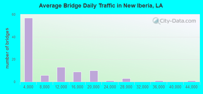
- 768,410Total average daily traffic
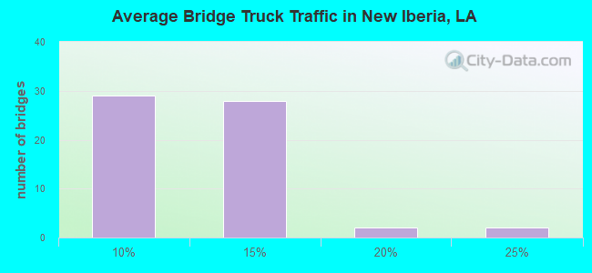
- 68,930Total average daily truck traffic
- National Bridge Inventory (NBI) Registered Bridges for New Iberia
- No street view available for this location
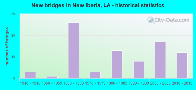
- New bridges - historical statistics
- 31940-1949
- 11950-1959
- 261960-1969
- 31970-1979
- 131980-1989
- 81990-1999
- 172000-2009
- 122010-2019
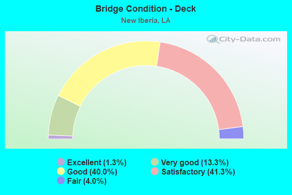
- Bridge Condition - Deck
- 1.3%Excellent
- 13.3%Very good
- 40.0%Good
- 41.3%Satisfactory
- 4.0%Fair
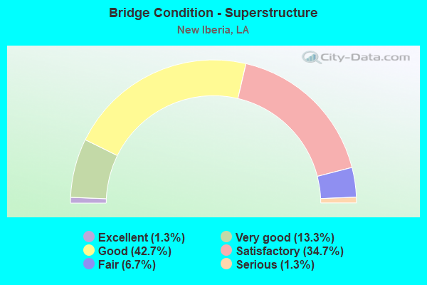
- Bridge Condition - Superstructure
- 1.3%Excellent
- 13.3%Very good
- 42.7%Good
- 34.7%Satisfactory
- 6.7%Fair
- 1.3%Serious
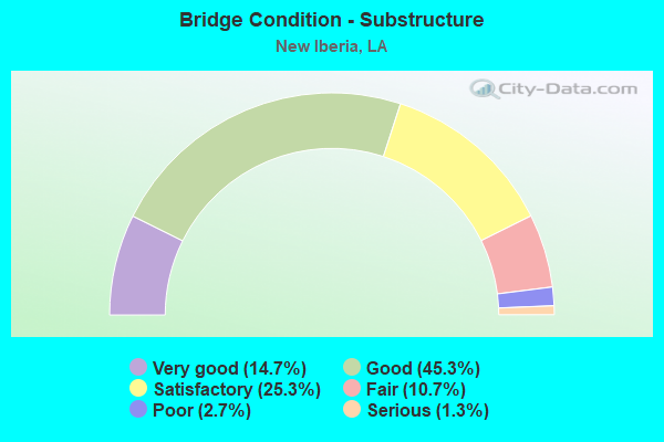
- Bridge Condition - Substructure
- 14.7%Very good
- 45.3%Good
- 25.3%Satisfactory
- 10.7%Fair
- 2.7%Poor
- 1.3%Serious
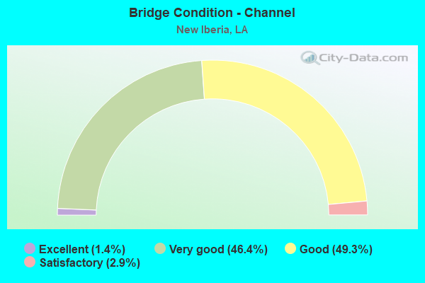
- Bridge Condition - Channel
- 1.4%Excellent
- 46.4%Very good
- 49.3%Good
- 2.9%Satisfactory
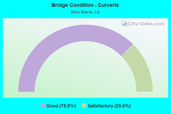
- Bridge Condition - Culverts
- 75.0%Good
- 25.0%Satisfactory
Find on map >> Show street view
Structure Number: 3230000000608, Location: 0.10 Mi E of LA 83 (Lat: 29.959300, Lng: -91.820400), Route carried "on" structure: Ramp US 90, Year Built: 1969, Status: Open, Structure Length: 0.91m (2.99ft), Average Daily Traffic: 2,580 (year 2016), Truck Traffic: 10%, Average Future Daily Traffic: 1,524 (year 2036), Design Load: HS 20, Features Intersected: PEEBLES CANAL
Minimum Vertical Clearance: 30+ m (98+ ft), Kilometerpoint: 0.143, Lanes on structure: 2, Owner: State Highway Agency, Approaching Roadway Width: 20.1m (65.9ft), Skew: 10 degrees, Material/Design: Concrete, Design/Construction: Culvert, Number Of Spans In Main Unit: 3, Length of Maximum Span: 2.7m (8.9ft), Curb-To-Curb Width: 11.6m (38.1ft), Out-to-Out Width: 39.4m (129.3ft)
Condition: Channel: Very good, Culverts: Satisfactory, Operating Rating: 42.1 metric tons, Method Used To Determine Operating Rating: Load and Resistance Factor Rating (LRFR) rating reported by rating factor(RF) method using HL-93 loadings, Inventory Rating: 32.4 metric tons, Method Used To Determine Inventory Rating: Load and Resistance Factor Rating (LRFR) rating reported by rating factor(RF) method using HL-93 loadings, Structural Evaluation: Equal to present minimum criteria, Deck Geometry: Superior to present desirable criteria, Waterway Adequacy: Equal to present desirable criteria, Approach Roadway Alignment: Equal to present desirable criteria, Designated Inspection Frequency: Every 24 months, Inspection Date: September 2020, Deck Structure Type: Concrete Cast-file-Place
Find on map >> Show street view
Structure Number: 32300000006082, Location: 6.20 Mi W of LA 85 (Lat: 29.960469, Lng: -91.819700), Route carried "on" structure: Ramp US 90, Year Built: 1969, Status: Open, Structure Length: 0.91m (2.99ft), Average Daily Traffic: 2,580 (year 2016), Truck Traffic: 10%, Average Future Daily Traffic: 1,524 (year 2036), Design Load: HS 20, Features Intersected: PEEBLES CANNAL
Minimum Vertical Clearance: 30+ m (98+ ft), Kilometerpoint: 0.521, Lanes on structure: 2, Owner: State Highway Agency, Approaching Roadway Width: 20.1m (65.9ft), Skew: 10 degrees, Material/Design: Concrete, Design/Construction: Culvert, Number Of Spans In Main Unit: 3, Length of Maximum Span: 2.7m (8.9ft), Curb-To-Curb Width: 11.6m (38.1ft), Out-to-Out Width: 42.3m (138.8ft)
Condition: Channel: Very good, Culverts: Satisfactory, Operating Rating: 42.1 metric tons, Method Used To Determine Operating Rating: Load and Resistance Factor Rating (LRFR) rating reported by rating factor(RF) method using HL-93 loadings, Inventory Rating: 32.4 metric tons, Method Used To Determine Inventory Rating: Load and Resistance Factor Rating (LRFR) rating reported by rating factor(RF) method using HL-93 loadings, Structural Evaluation: Equal to present minimum criteria, Deck Geometry: Superior to present desirable criteria, Waterway Adequacy: Equal to present desirable criteria, Approach Roadway Alignment: Equal to present desirable criteria, Designated Inspection Frequency: Every 24 months, Inspection Date: September 2020, Deck Structure Type: Concrete Cast-file-Place
Find on map >> Show street view
Structure Number: 32300000030135, Location: 0.83 Mi W of La 83 (Lat: 29.948839, Lng: -91.837269), Route carried "on" structure: County highway , Year Built: 2013, Status: Open, Structure Length: 3.05m (10.01ft), Average Daily Traffic: 2,313 (year 2021), Average Future Daily Traffic: 2,544 (year 2041), Design Load: HS 20, Features Intersected: Commercial Canal, Facility Carried by Structure: Port Rd
Minimum Vertical Clearance: 30+ m (98+ ft), Kilometerpoint: 0.000, Lanes on structure: 2, Owner: County Highway Agency, Approaching Roadway Width: 0.6m (2.0ft), Skew: 6 degrees, Material/Design: Prestressed concrete, Design/Construction: Slab, Number Of Spans In Main Unit: 5, Length of Maximum Span: 6.1m (20.0ft), Curb-To-Curb Width: 7.3m (24.0ft), Out-to-Out Width: 8.1m (26.6ft)
Condition: Deck: Good, Superstructure: Good, Substructure: Good, Channel: Excellent, Operating Rating: 50.5 metric tons, Method Used To Determine Operating Rating: Load and Resistance Factor Rating (LRFR) rating reported by rating factor(RF) method using HL-93 loadings, Inventory Rating: 39.2 metric tons, Method Used To Determine Inventory Rating: Load and Resistance Factor Rating (LRFR) rating reported by rating factor(RF) method using HL-93 loadings, Structural Evaluation: Better than present minimum criteria, Deck Geometry: High priority of replacement, Waterway Adequacy: Equal to present desirable criteria, Approach Roadway Alignment: Equal to present desirable criteria, Designated Inspection Frequency: Every 24 months, Inspection Date: October 2020, Deck Structure Type: Concrete Precast Panels, Wearing Surface/Protective System: Wearing Surface: Monolithic Concrete
Find on map >> Show street view
Structure Number: 32300000030381, Location: 4.33 Mi SE of LA 88 (Lat: 30.004339, Lng: -91.885300), Route carried "on" structure: US 90, Year Built: 2009, Status: Open, Structure Length: 55.53m (182.19ft), Average Daily Traffic: 17,250 (year 2016), Truck Traffic: 10%, Average Future Daily Traffic: 12,168 (year 2036), Design Load: HS 20, Features Intersected: LA 675
Minimum Vertical Clearance: 30+ m (98+ ft), Kilometerpoint: 9.556, Lanes on structure: 2, Lanes under structure: 4, Base Highway Network: Yes (Inventory Route: 424-04-1, Subroute: 10), Owner: State Highway Agency, Approaching Roadway Width: 11.6m (38.1ft), Skew: 34 degrees, Material/Design: Concrete, Design/Construction: Stringer/Multi-beam, Number Of Spans In Main Unit: 25, Length of Maximum Span: 35.4m (116.1ft), Curb-To-Curb Width: 12.2m (40.0ft), Out-to-Out Width: 13.0m (42.7ft)
Condition: Deck: Good, Superstructure: Good, Substructure: Good, Operating Rating: 56.7 metric tons, Method Used To Determine Operating Rating: Load and Resistance Factor Rating (LRFR) rating reported by rating factor(RF) method using HL-93 loadings, Inventory Rating: 37.6 metric tons, Method Used To Determine Inventory Rating: Load and Resistance Factor Rating (LRFR) rating reported by rating factor(RF) method using HL-93 loadings, Structural Evaluation: Better than present minimum criteria, Deck Geometry: Better than present minimum criteria, Underclear: High priority of corrective action, Approach Roadway Alignment: Equal to present desirable criteria, Designated Inspection Frequency: Every 24 months, Inspection Date: Febuary 2020, Deck Structure Type: Concrete Cast-file-Place, Wearing Surface/Protective System: Wearing Surface: Monolithic Concrete
Find on map >> Show street view
Structure Number: 32300000030382, Location: 4.33 Mi SE of LA 88 (Lat: 30.004531, Lng: -91.885111), Route carried "on" structure: US 90, Year Built: 2009, Status: Open, Structure Length: 55.53m (182.19ft), Average Daily Traffic: 17,250 (year 2016), Truck Traffic: 10%, Average Future Daily Traffic: 12,168 (year 2036), Design Load: HS 20, Features Intersected: LA 675
Minimum Vertical Clearance: 30+ m (98+ ft), Kilometerpoint: 23.741, Lanes on structure: 2, Lanes under structure: 4, Base Highway Network: Yes (Inventory Route: 424-04-2, Subroute: 10), Owner: State Highway Agency, Approaching Roadway Width: 11.6m (38.1ft), Skew: 34 degrees, Material/Design: Concrete, Design/Construction: Stringer/Multi-beam, Number Of Spans In Main Unit: 25, Length of Maximum Span: 35.4m (116.1ft), Curb-To-Curb Width: 12.2m (40.0ft), Out-to-Out Width: 13.0m (42.7ft)
Condition: Deck: Good, Superstructure: Good, Substructure: Good, Operating Rating: 56.7 metric tons, Method Used To Determine Operating Rating: Load and Resistance Factor Rating (LRFR) rating reported by rating factor(RF) method using HL-93 loadings, Inventory Rating: 37.6 metric tons, Method Used To Determine Inventory Rating: Load and Resistance Factor Rating (LRFR) rating reported by rating factor(RF) method using HL-93 loadings, Structural Evaluation: Better than present minimum criteria, Deck Geometry: Better than present minimum criteria, Underclear: High priority of corrective action, Approach Roadway Alignment: Equal to present desirable criteria, Designated Inspection Frequency: Every 24 months, Inspection Date: Febuary 2020, Deck Structure Type: Concrete Cast-file-Place, Wearing Surface/Protective System: Wearing Surface: Monolithic Concrete
Find on map >> Show street view
Structure Number: 32300000030393, Location: 3.0 MI SE of LA 88 (Lat: 30.014131, Lng: -91.902200), Route carried "on" structure: ServiceUS 90, Year Built: 2009, Status: Open, Structure Length: 3.05m (10.01ft), Average Daily Traffic: 27,454 (year 2017), Truck Traffic: 9%, Average Future Daily Traffic: 30,199 (year 2027), Design Load: HS 20, Features Intersected: SEGURA BRANCH CANAL
Minimum Vertical Clearance: 30+ m (98+ ft), Kilometerpoint: 2.424, Lanes on structure: 2, Owner: State Highway Agency, Approaching Roadway Width: 6.7m (22.0ft), Skew: 30 degrees, Material/Design: Concrete, Design/Construction: Slab, Number Of Spans In Main Unit: 5, Length of Maximum Span: 6.1m (20.0ft), Curb-To-Curb Width: 10.4m (34.1ft), Out-to-Out Width: 11.1m (36.4ft)
Condition: Deck: Good, Superstructure: Good, Substructure: Good, Channel: Very good, Operating Rating: 41.1 metric tons, Method Used To Determine Operating Rating: Load and Resistance Factor Rating (LRFR) rating reported by rating factor(RF) method using HL-93 loadings, Inventory Rating: 31.8 metric tons, Method Used To Determine Inventory Rating: Load and Resistance Factor Rating (LRFR) rating reported by rating factor(RF) method using HL-93 loadings, Structural Evaluation: Better than present minimum criteria, Deck Geometry: Meets minimum limits, Waterway Adequacy: Equal to present desirable criteria, Approach Roadway Alignment: Equal to present desirable criteria, Designated Inspection Frequency: Every 24 months, Inspection Date: March 2021, Deck Structure Type: Concrete Cast-file-Place, Wearing Surface/Protective System: Wearing Surface: Monolithic Concrete
Find on map >> Show street view
Structure Number: 32300000030394, Location: 3.10 Mi SE of LA 88 (Lat: 30.013731, Lng: -91.902800), Route carried "on" structure: ServiceUS 90, Year Built: 2009, Status: Open, Structure Length: 3.05m (10.01ft), Average Daily Traffic: 27,454 (year 2017), Truck Traffic: 9%, Average Future Daily Traffic: 30,199 (year 2027), Design Load: HS 20, Features Intersected: SEGURA BRANCH CANAL
Minimum Vertical Clearance: 30+ m (98+ ft), Kilometerpoint: 5.065, Lanes on structure: 2, Owner: State Highway Agency, Approaching Roadway Width: 6.7m (22.0ft), Skew: 30 degrees, Material/Design: Concrete, Design/Construction: Slab, Number Of Spans In Main Unit: 5, Length of Maximum Span: 6.1m (20.0ft), Curb-To-Curb Width: 10.4m (34.1ft), Out-to-Out Width: 11.1m (36.4ft)
Condition: Deck: Good, Superstructure: Good, Substructure: Good, Channel: Very good, Operating Rating: 41.1 metric tons, Method Used To Determine Operating Rating: Load and Resistance Factor Rating (LRFR) rating reported by rating factor(RF) method using HL-93 loadings, Inventory Rating: 31.8 metric tons, Method Used To Determine Inventory Rating: Load and Resistance Factor Rating (LRFR) rating reported by rating factor(RF) method using HL-93 loadings, Structural Evaluation: Better than present minimum criteria, Deck Geometry: Meets minimum limits, Waterway Adequacy: Equal to present desirable criteria, Approach Roadway Alignment: Equal to present desirable criteria, Designated Inspection Frequency: Every 24 months, Inspection Date: March 2021, Deck Structure Type: Concrete Cast-file-Place, Wearing Surface/Protective System: Wearing Surface: Monolithic Concrete
Find on map >> Show street view
Structure Number: 32300000030397, Location: 3.40 Mi W of LA 688 (Lat: 29.918350, Lng: -91.726461), Route carried "on" structure: State highway 90, Year Built: 2011, Status: Open, Structure Length: 46.97m (154.10ft), Average Daily Traffic: 11,200 (year 2016), Truck Traffic: 24%, Average Future Daily Traffic: 7,884 (year 2036), Design Load: HS 20, Features Intersected: LA 85
Minimum Vertical Clearance: 30+ m (98+ ft), Kilometerpoint: 6.058, Lanes on structure: 2, Lanes under structure: 4, Base Highway Network: Yes (Inventory Route: 424-04-2, Subroute: 10), Owner: State Highway Agency, Approaching Roadway Width: 11.6m (38.1ft), Skew: 30 degrees, Material/Design: Concrete, Design/Construction: Stringer/Multi-beam, Number Of Spans In Main Unit: 19, Length of Maximum Span: 34.7m (113.8ft), Curb-To-Curb Width: 11.9m (39.0ft), Out-to-Out Width: 12.9m (42.3ft)
Condition: Deck: Very good, Superstructure: Very good, Substructure: Very good, Operating Rating: 39.9 metric tons, Method Used To Determine Operating Rating: Load and Resistance Factor Rating (LRFR) rating reported by rating factor(RF) method using HL-93 loadings, Inventory Rating: 34.7 metric tons, Method Used To Determine Inventory Rating: Load and Resistance Factor Rating (LRFR) rating reported by rating factor(RF) method using HL-93 loadings, Structural Evaluation: Equal to present desirable criteria, Deck Geometry: Better than present minimum criteria, Underclear: Superior to present desirable criteria, Approach Roadway Alignment: Equal to present desirable criteria, Designated Inspection Frequency: Every 24 months, Inspection Date: June 2021, Deck Structure Type: Concrete Cast-file-Place, Wearing Surface/Protective System: Wearing Surface: Monolithic Concrete
Find on map >> Show street view
Structure Number: 32300000030398, Location: 3.40 Mi W of LA 688 (Lat: 29.920769, Lng: -91.730500), Route carried "on" structure: US 90, Year Built: 2011, Status: Open, Structure Length: 46.97m (154.10ft), Average Daily Traffic: 11,200 (year 2016), Truck Traffic: 24%, Average Future Daily Traffic: 7,884 (year 2036), Design Load: HS 20, Features Intersected: LA 85
Minimum Vertical Clearance: 30+ m (98+ ft), Kilometerpoint: 27.262, Lanes on structure: 2, Lanes under structure: 4, Base Highway Network: Yes (Inventory Route: 424-04-1, Subroute: 10), Owner: State Highway Agency, Approaching Roadway Width: 11.6m (38.1ft), Skew: 30 degrees, Material/Design: Concrete, Design/Construction: Stringer/Multi-beam, Number Of Spans In Main Unit: 19, Length of Maximum Span: 34.7m (113.8ft), Curb-To-Curb Width: 11.9m (39.0ft), Out-to-Out Width: 12.9m (42.3ft)
Condition: Deck: Very good, Superstructure: Good, Substructure: Good, Operating Rating: 39.9 metric tons, Method Used To Determine Operating Rating: Load and Resistance Factor Rating (LRFR) rating reported by rating factor(RF) method using HL-93 loadings, Inventory Rating: 34.7 metric tons, Method Used To Determine Inventory Rating: Load and Resistance Factor Rating (LRFR) rating reported by rating factor(RF) method using HL-93 loadings, Structural Evaluation: Better than present minimum criteria, Deck Geometry: Better than present minimum criteria, Underclear: Superior to present desirable criteria, Approach Roadway Alignment: Equal to present desirable criteria, Designated Inspection Frequency: Every 24 months, Inspection Date: June 2021, Deck Structure Type: Concrete Cast-file-Place, Wearing Surface/Protective System: Wearing Surface: Monolithic Concrete
Find on map >> Show street view
Structure Number: 32300000030399, Location: 4.3 MI S of LA 85 (Lat: 29.851631, Lng: -91.787631), Route carried "on" structure: State highway 83, Year Built: 2011, Status: Open, Structure Length: 9.91m (32.51ft), Average Daily Traffic: 2,115 (year 2020), Truck Traffic: 13%, Average Future Daily Traffic: 2,326 (year 2040), Design Load: HS 20, Features Intersected: STUMPY BAYOU
Minimum Vertical Clearance: 30+ m (98+ ft), Kilometerpoint: 5.617, Lanes on structure: 2, Owner: State Highway Agency, Approaching Roadway Width: 10.7m (35.1ft), Skew: 35 degrees, Material/Design: Steel, Design/Construction: Stringer/Multi-beam, Number Of Spans In Main Unit: 3, Number Of Approach Spans: 5, Length of Maximum Span: 26.5m (86.9ft), Curb-To-Curb Width: 10.0m (32.8ft), Out-to-Out Width: 10.8m (35.4ft)
Condition: Deck: Very good, Superstructure: Good, Substructure: Very good, Channel: Very good, Operating Rating: 22.4 metric tons, Method Used To Determine Operating Rating: Load and Resistance Factor Rating (LRFR) rating reported by rating factor(RF) method using HL-93 loadings, Inventory Rating: 17.2 metric tons, Method Used To Determine Inventory Rating: Load and Resistance Factor Rating (LRFR) rating reported by rating factor(RF) method using HL-93 loadings, Structural Evaluation: Meets minimum limits, Deck Geometry: Meets minimum limits, Waterway Adequacy: Equal to present desirable criteria, Approach Roadway Alignment: Equal to present desirable criteria, Designated Inspection Frequency: Every 24 months, Inspection Date: August 2021, Deck Structure Type: Concrete Cast-file-Place, Wearing Surface/Protective System: Wearing Surface: Monolithic Concrete
Find on map >> Show street view
Structure Number: 3230000003043, Location: 0.08 MI EAST OF LA 182 (Lat: 30.009350, Lng: -91.819800), Route carried "on" structure: State highway 3156, Year Built: 2014, Status: Open, Structure Length: 6.52m (21.39ft), Average Daily Traffic: 6,900 (year 2016), Truck Traffic: 9%, Average Future Daily Traffic: 4,140 (year 2036), Design Load: HS 20, Features Intersected: TECHE BAYOU
Minimum Vertical Clearance: 6.00m (19.69ft), Kilometerpoint: 0.257, Lanes on structure: 2, Owner: State Highway Agency, Approaching Roadway Width: 6.4m (21.0ft), Skew: 30 degrees, Material/Design: Steel, Design/Construction: Movable - Swing, Number Of Spans In Main Unit: 2, Number Of Approach Spans: 4, Length of Maximum Span: 28.0m (91.9ft), Curb or Sidewalk Widths: Left: 0.0m, Right: 1.8m (5.9ft), Curb-To-Curb Width: 9.8m (32.2ft), Out-to-Out Width: 12.8m (42.0ft)
Condition: Deck: Very good, Superstructure: Very good, Substructure: Good, Channel: Good, Operating Rating: 36.0 metric tons, Method Used To Determine Operating Rating: Load and Resistance Factor Rating (LRFR) rating reported by rating factor(RF) method using HL-93 loadings, Inventory Rating: 27.5 metric tons, Method Used To Determine Inventory Rating: Load and Resistance Factor Rating (LRFR) rating reported by rating factor(RF) method using HL-93 loadings, Structural Evaluation: Equal to present minimum criteria, Deck Geometry: Meets minimum limits, Waterway Adequacy: Equal to present desirable criteria, Approach Roadway Alignment: Equal to present desirable criteria, Designated Inspection Frequency: Every 24 months, Critical Feature Inspection Frequency: Every 24 months, Underwater Inspection Frequency: Every 60 months, Inspection Date: March 2020, Critical Feature Inspection Date: March 2020, Underwater Inspection Date: May 2020, Deck Structure Type: Concrete Cast-file-Place, Wearing Surface/Protective System: Wearing Surface: Monolithic Concrete
Find on map >> Show street view
Structure Number: 32300000030474, Location: 1.28 MI E OF LA 329 (Lat: 29.956169, Lng: -91.851050), Route carried "on" structure: County highway , Year Built: 2016, Status: Open, Structure Length: 2.44m (8.01ft), Average Daily Traffic: 633 (year 2021), Average Future Daily Traffic: 696 (year 2041), Design Load: HS 20, Features Intersected: Rodere Canal, Facility Carried by Structure: David Dubon Rd
Minimum Vertical Clearance: 30+ m (98+ ft), Kilometerpoint: 2.060, Lanes on structure: 2, Owner: County Highway Agency, Approaching Roadway Width: 6.4m (21.0ft), Skew: 30 degrees, Material/Design: Concrete, Design/Construction: Slab, Number Of Spans In Main Unit: 4, Length of Maximum Span: 6.1m (20.0ft), Curb-To-Curb Width: 7.1m (23.3ft), Out-to-Out Width: 8.2m (26.9ft)
Condition: Deck: Excellent, Superstructure: Excellent, Substructure: Good, Channel: Good, Operating Rating: 48.6 metric tons, Method Used To Determine Operating Rating: Load and Resistance Factor Rating (LRFR) rating reported by rating factor(RF) method using HL-93 loadings, Inventory Rating: 37.6 metric tons, Method Used To Determine Inventory Rating: Load and Resistance Factor Rating (LRFR) rating reported by rating factor(RF) method using HL-93 loadings, Structural Evaluation: Better than present minimum criteria, Deck Geometry: Meets minimum limits, Waterway Adequacy: Equal to present desirable criteria, Approach Roadway Alignment: Equal to present desirable criteria, Designated Inspection Frequency: Every 24 months, Underwater Inspection Frequency: Every 60 months, Inspection Date: October 2020, Underwater Inspection Date: January 2019, Deck Structure Type: Concrete Precast Panels, Wearing Surface/Protective System: Wearing Surface: Monolithic Concrete
Find on map >> Show street view
Structure Number: 32300000030487, Location: 1.0 MI. S. OF LA 86 (Lat: 29.994089, Lng: -91.736989), Route carried "on" structure: County highway , Year Built: 2017, Status: Open, Structure Length: 2.44m (8.01ft), Average Daily Traffic: 660 (year 2022), Average Future Daily Traffic: 726 (year 2042), Design Load: Greater than HL93, Features Intersected: CANAL, Facility Carried by Structure: Crochet Rd
Minimum Vertical Clearance: 30+ m (98+ ft), Kilometerpoint: 2.063, Lanes on structure: 2, Owner: County Highway Agency, Approaching Roadway Width: 7.3m (24.0ft), Skew: 1 degrees, Material/Design: Concrete, Design/Construction: Slab, Number Of Spans In Main Unit: 4, Length of Maximum Span: 6.1m (20.0ft), Curb-To-Curb Width: 7.3m (24.0ft), Out-to-Out Width: 8.2m (26.9ft)
Condition: Deck: Very good, Superstructure: Very good, Substructure: Very good, Channel: Very good, Operating Rating: 50.2 metric tons, Method Used To Determine Operating Rating: Load and Resistance Factor Rating (LRFR) rating reported by rating factor(RF) method using HL-93 loadings, Inventory Rating: 38.6 metric tons, Method Used To Determine Inventory Rating: Load and Resistance Factor Rating (LRFR) rating reported by rating factor(RF) method using HL-93 loadings, Structural Evaluation: Equal to present desirable criteria, Deck Geometry: Meets minimum limits, Waterway Adequacy: Equal to present desirable criteria, Approach Roadway Alignment: Equal to present minimum criteria, Designated Inspection Frequency: Every 24 months, Inspection Date: October 2020, Deck Structure Type: Concrete Precast Panels
Find on map >> Show street view
Structure Number: 32300000030518, Location: 0.5 mi. NE of US 90 (Lat: 29.981619, Lng: -91.826631), Route carried "on" structure: County highway , Year Built: 2018, Status: Open, Structure Length: 1.83m (6.00ft), Average Daily Traffic: 311 (year 2020), Average Future Daily Traffic: 612 (year 2040), Design Load: Greater than HL93, Features Intersected: Commercial Canal, Facility Carried by Structure: Briarwood Dr
Minimum Vertical Clearance: 30+ m (98+ ft), Kilometerpoint: 0.013, Lanes on structure: 2, Owner: County Highway Agency, Approaching Roadway Width: 8.9m (29.2ft), Material/Design: Prestressed concrete, Design/Construction: Slab, Number Of Spans In Main Unit: 3, Length of Maximum Span: 6.1m (20.0ft), Curb-To-Curb Width: 7.9m (25.9ft), Out-to-Out Width: 8.5m (27.9ft)
Condition: Deck: Very good, Superstructure: Very good, Substructure: Very good, Channel: Very good, Operating Rating: 57.7 metric tons, Method Used To Determine Operating Rating: Load and Resistance Factor Rating (LRFR) rating reported by rating factor(RF) method using HL-93 loadings, Inventory Rating: 44.4 metric tons, Method Used To Determine Inventory Rating: Load and Resistance Factor Rating (LRFR) rating reported by rating factor(RF) method using HL-93 loadings, Structural Evaluation: Equal to present desirable criteria, Deck Geometry: Somewhat better than minimum adequacy, Waterway Adequacy: Equal to present desirable criteria, Approach Roadway Alignment: High priority of corrective action, Designated Inspection Frequency: Every 24 months, Inspection Date: October 2020, Deck Structure Type: Concrete Precast Panels
Find on map >> Show street view
Structure Number: 32300000200715, Location: 0.90 Mi. S of La 14 (Lat: 29.974039, Lng: -91.882969), Route carried "on" structure: County highway , Year Built: 2012, Status: Open, Structure Length: 1.83m (6.00ft), Average Daily Traffic: 936 (year 2021), Average Future Daily Traffic: 1,030 (year 2041), Design Load: HS 20, Features Intersected: Armenco Branch Canal, Facility Carried by Structure: Hazard Rd
Minimum Vertical Clearance: 30+ m (98+ ft), Kilometerpoint: 0.000, Lanes on structure: 2, Owner: County Highway Agency, Approaching Roadway Width: 7.3m (24.0ft), Skew: 33 degrees, Material/Design: Concrete, Design/Construction: Slab, Number Of Spans In Main Unit: 3, Length of Maximum Span: 6.1m (20.0ft), Curb-To-Curb Width: 8.5m (27.9ft), Out-to-Out Width: 9.4m (30.8ft)
Condition: Deck: Very good, Superstructure: Very good, Substructure: Very good, Channel: Very good, Operating Rating: 89.8 metric tons, Method Used To Determine Operating Rating: Load Factor (LF), Inventory Rating: 55.3 metric tons, Method Used To Determine Inventory Rating: Load Factor (LF), Structural Evaluation: Equal to present desirable criteria, Deck Geometry: Somewhat better than minimum adequacy, Waterway Adequacy: Equal to present desirable criteria, Approach Roadway Alignment: Equal to present minimum criteria, Designated Inspection Frequency: Every 24 months, Inspection Date: October 2020, Deck Structure Type: Concrete Precast Panels, Wearing Surface/Protective System: Wearing Surface: Monolithic Concrete
Find on map >> Show street view
Structure Number: 32300000200736, Location: 2.1 Mi. E. of La 329 (Lat: 29.956261, Lng: -91.836819), Route carried "on" structure: County highway , Year Built: 2013, Status: Open, Structure Length: 2.44m (8.01ft), Average Daily Traffic: 1,184 (year 2021), Average Future Daily Traffic: 1,302 (year 2041), Design Load: HS 20, Features Intersected: Commercial Canal, Facility Carried by Structure: David Duboin Rd
Minimum Vertical Clearance: 30+ m (98+ ft), Kilometerpoint: 0.000, Lanes on structure: 2, Owner: County Highway Agency, Approaching Roadway Width: 6.1m (20.0ft), Material/Design: Concrete, Design/Construction: Slab, Number Of Spans In Main Unit: 4, Length of Maximum Span: 6.1m (20.0ft), Curb-To-Curb Width: 9.8m (32.2ft), Out-to-Out Width: 10.5m (34.4ft)
Condition: Deck: Good, Superstructure: Good, Substructure: Good, Channel: Very good, Operating Rating: 54.8 metric tons, Method Used To Determine Operating Rating: Load and Resistance Factor Rating (LRFR) rating reported by rating factor(RF) method using HL-93 loadings, Inventory Rating: 42.4 metric tons, Method Used To Determine Inventory Rating: Load and Resistance Factor Rating (LRFR) rating reported by rating factor(RF) method using HL-93 loadings, Structural Evaluation: Better than present minimum criteria, Deck Geometry: Somewhat better than minimum adequacy, Waterway Adequacy: Equal to present desirable criteria, Approach Roadway Alignment: High priority of corrective action, Designated Inspection Frequency: Every 24 months, Inspection Date: October 2020, Deck Structure Type: Concrete Cast-file-Place, Wearing Surface/Protective System: Wearing Surface: Monolithic Concrete
Find on map >> Show street view
Structure Number: 32300000200739, Location: 1.73 Mi W of La 83 (Lat: 29.948739, Lng: -91.852089), Route carried "on" structure: County highway , Year Built: 2012, Status: Open, Structure Length: 3.05m (10.01ft), Average Daily Traffic: 836 (year 2021), Average Future Daily Traffic: 919 (year 2041), Design Load: HS 20, Features Intersected: Rodere Canal, Facility Carried by Structure: Port Rd
Minimum Vertical Clearance: 30+ m (98+ ft), Kilometerpoint: 0.000, Lanes on structure: 2, Owner: County Highway Agency, Approaching Roadway Width: 9.8m (32.2ft), Skew: 34 degrees, Material/Design: Concrete, Design/Construction: Slab, Number Of Spans In Main Unit: 5, Length of Maximum Span: 6.1m (20.0ft), Curb-To-Curb Width: 8.5m (27.9ft), Out-to-Out Width: 30.5m (100.1ft)
Condition: Deck: Very good, Superstructure: Very good, Substructure: Good, Channel: Good, Operating Rating: 89.8 metric tons, Method Used To Determine Operating Rating: Load Factor (LF), Inventory Rating: 55.3 metric tons, Method Used To Determine Inventory Rating: Load Factor (LF), Structural Evaluation: Better than present minimum criteria, Deck Geometry: Somewhat better than minimum adequacy, Waterway Adequacy: Equal to present desirable criteria, Approach Roadway Alignment: Equal to present desirable criteria, Designated Inspection Frequency: Every 24 months, Underwater Inspection Frequency: Every 60 months, Inspection Date: October 2020, Underwater Inspection Date: May 2020, Deck Structure Type: Concrete Precast Panels, Wearing Surface/Protective System: Wearing Surface: Monolithic Concrete
Find on map >> Show street view
Structure Number: 32300000200754, Location: 2.50 Mi W of La 83 (Lat: 29.942269, Lng: -91.857439), Route carried "on" structure: County highway , Year Built: 2012, Status: Open, Structure Length: 2.44m (8.01ft), Average Daily Traffic: 1,776 (year 2021), Average Future Daily Traffic: 1,954 (year 2041), Design Load: HS 20, Features Intersected: Rodere Lateral, Facility Carried by Structure: Port Rd
Minimum Vertical Clearance: 30+ m (98+ ft), Kilometerpoint: 0.000, Lanes on structure: 2, Owner: County Highway Agency, Approaching Roadway Width: 9.4m (30.8ft), Skew: 34 degrees, Material/Design: Concrete, Design/Construction: Slab, Number Of Spans In Main Unit: 4, Length of Maximum Span: 6.1m (20.0ft), Curb-To-Curb Width: 7.3m (24.0ft), Out-to-Out Width: 7.9m (25.9ft)
Condition: Deck: Very good, Superstructure: Very good, Substructure: Very good, Channel: Very good, Operating Rating: 45.7 metric tons, Method Used To Determine Operating Rating: Load and Resistance Factor Rating (LRFR) rating reported by rating factor(RF) method using HL-93 loadings, Inventory Rating: 35.3 metric tons, Method Used To Determine Inventory Rating: Load and Resistance Factor Rating (LRFR) rating reported by rating factor(RF) method using HL-93 loadings, Structural Evaluation: Equal to present desirable criteria, Deck Geometry: Meets minimum limits, Waterway Adequacy: Equal to present desirable criteria, Approach Roadway Alignment: Equal to present desirable criteria, Designated Inspection Frequency: Every 24 months, Inspection Date: October 2020, Deck Structure Type: Concrete Precast Panels, Wearing Surface/Protective System: Wearing Surface: Monolithic Concrete
Find on map >> Show street view
Structure Number: 32300550705261, Location: 5.26 MI EAST OF LA 330 (Lat: 29.967800, Lng: -91.907700), Route carried "on" structure: State highway 14, Year Built: 1988, Status: Open, Structure Length: 4.88m (16.01ft), Average Daily Traffic: 6,300 (year 2016), Truck Traffic: 9%, Average Future Daily Traffic: 4,464 (year 2036), Design Load: HS 20, Features Intersected: BAYOU PETITE ANSE
Minimum Vertical Clearance: 30+ m (98+ ft), Kilometerpoint: 8.602, Lanes on structure: 2, Owner: State Highway Agency, Approaching Roadway Width: 12.2m (40.0ft), Skew: 16 degrees, Material/Design: Concrete, Design/Construction: Slab, Number Of Spans In Main Unit: 8, Length of Maximum Span: 6.1m (20.0ft), Curb-To-Curb Width: 12.3m (40.4ft), Out-to-Out Width: 13.0m (42.7ft)
Condition: Deck: Good, Superstructure: Good, Substructure: Good, Channel: Good, Operating Rating: 68.0 metric tons, Method Used To Determine Operating Rating: Load Factor (LF), Inventory Rating: 40.8 metric tons, Method Used To Determine Inventory Rating: Load Factor (LF), Structural Evaluation: Better than present minimum criteria, Deck Geometry: Better than present minimum criteria, Waterway Adequacy: Equal to present desirable criteria, Approach Roadway Alignment: Better than present minimum criteria, Designated Inspection Frequency: Every 24 months, Underwater Inspection Frequency: Every 60 months, Inspection Date: Febuary 2021, Underwater Inspection Date: August 2018, Deck Structure Type: Concrete Cast-file-Place
Find on map >> Show street view
Structure Number: 32300550705262, Location: 1.5 MI SW of LA 676 (Lat: 29.968331, Lng: -91.907500), Route carried "on" structure: State highway 14, Year Built: 1988, Status: Open, Structure Length: 4.88m (16.01ft), Average Daily Traffic: 6,300 (year 2016), Truck Traffic: 9%, Average Future Daily Traffic: 6,930 (year 2036), Design Load: HS 20, Features Intersected: BAYOU PETITE ANSE
Minimum Vertical Clearance: 30+ m (98+ ft), Kilometerpoint: 10.443, Lanes on structure: 2, Owner: State Highway Agency, Approaching Roadway Width: 12.2m (40.0ft), Skew: 16 degrees, Material/Design: Concrete, Design/Construction: Slab, Number Of Spans In Main Unit: 8, Length of Maximum Span: 6.1m (20.0ft), Curb-To-Curb Width: 12.3m (40.4ft), Out-to-Out Width: 13.0m (42.7ft)
Condition: Deck: Good, Superstructure: Good, Substructure: Good, Channel: Good, Operating Rating: 68.0 metric tons, Method Used To Determine Operating Rating: Load Factor (LF), Inventory Rating: 40.8 metric tons, Method Used To Determine Inventory Rating: Load Factor (LF), Structural Evaluation: Better than present minimum criteria, Deck Geometry: Better than present minimum criteria, Waterway Adequacy: Equal to present desirable criteria, Approach Roadway Alignment: Equal to present minimum criteria, Designated Inspection Frequency: Every 24 months, Underwater Inspection Frequency: Every 60 months, Inspection Date: Febuary 2021, Underwater Inspection Date: August 2018, Deck Structure Type: Concrete Cast-file-Place
Find on map >> Show street view
Structure Number: 32300550707861, Location: 1.0 MI WEST OF US 90 (Lat: 29.985181, Lng: -91.873000), Route carried "on" structure: State highway 14, Year Built: 1960, Status: Open, Structure Length: 2.44m (8.01ft), Average Daily Traffic: 7,750 (year 2016), Truck Traffic: 9%, Average Future Daily Traffic: 5,508 (year 2036), Design Load: HS 20, Features Intersected: ARMANCO CANAL
Minimum Vertical Clearance: 30+ m (98+ ft), Kilometerpoint: 12.806, Lanes on structure: 2, Owner: State Highway Agency, Approaching Roadway Width: 14.0m (45.9ft), Skew: 10 degrees, Material/Design: Concrete, Design/Construction: Slab, Number Of Spans In Main Unit: 4, Length of Maximum Span: 6.1m (20.0ft), Curb-To-Curb Width: 8.6m (28.2ft), Out-to-Out Width: 9.9m (32.5ft)
Condition: Deck: Good, Superstructure: Good, Substructure: Good, Channel: Good, Operating Rating: 38.1 metric tons, Method Used To Determine Operating Rating: Load Factor (LF), Inventory Rating: 22.7 metric tons, Method Used To Determine Inventory Rating: Load Factor (LF), Structural Evaluation: Somewhat better than minimum adequacy, Deck Geometry: High priority of corrective action, Waterway Adequacy: Equal to present desirable criteria, Approach Roadway Alignment: Equal to present desirable criteria, Length Of Structure Improvement: 3.23m (10.60ft), Designated Inspection Frequency: Every 24 months, Inspection Date: Febuary 2021, Bridge Improvement Cost: $275,000, Total Project Cost: $412,000 ( Estimate for 2016), Deck Structure Type: Concrete Cast-file-Place
Find on map >> Show street view
Structure Number: 32300550707862, Location: 1.0 MI WEST OF US 90 (Lat: 29.985361, Lng: -91.872800), Route carried "on" structure: State highway 14, Year Built: 1981, Status: Open, Structure Length: 2.44m (8.01ft), Average Daily Traffic: 7,750 (year 2016), Truck Traffic: 9%, Average Future Daily Traffic: 5,508 (year 2036), Design Load: HS 20, Features Intersected: ARMENCO CANAL
Minimum Vertical Clearance: 30+ m (98+ ft), Kilometerpoint: 6.257, Lanes on structure: 2, Owner: State Highway Agency, Approaching Roadway Width: 12.2m (40.0ft), Skew: 10 degrees, Material/Design: Concrete, Design/Construction: Slab, Number Of Spans In Main Unit: 4, Length of Maximum Span: 6.1m (20.0ft), Curb-To-Curb Width: 12.2m (40.0ft), Out-to-Out Width: 13.1m (43.0ft)
Condition: Deck: Good, Superstructure: Good, Substructure: Good, Channel: Good, Operating Rating: 68.0 metric tons, Method Used To Determine Operating Rating: Load Factor (LF), Inventory Rating: 40.8 metric tons, Method Used To Determine Inventory Rating: Load Factor (LF), Structural Evaluation: Better than present minimum criteria, Deck Geometry: Better than present minimum criteria, Waterway Adequacy: Equal to present desirable criteria, Approach Roadway Alignment: Equal to present desirable criteria, Designated Inspection Frequency: Every 24 months, Inspection Date: Febuary 2021, Deck Structure Type: Concrete Cast-file-Place
Find on map >> Show street view
Structure Number: 32302360101131, Location: 1.1 MI SOUTH OF LA 14 (Lat: 29.970300, Lng: -91.836800), Route carried "on" structure: State highway 83, Year Built: 1948, Status: Open, Structure Length: 3.69m (12.11ft), Average Daily Traffic: 3,800 (year 2016), Truck Traffic: 9%, Average Future Daily Traffic: 2,280 (year 2036), Design Load: H 15, Features Intersected: COMMMERICAL CANAL
Minimum Vertical Clearance: 30+ m (98+ ft), Kilometerpoint: 1.822, Lanes on structure: 2, Owner: State Highway Agency, Approaching Roadway Width: 10.4m (34.1ft), Material/Design: Steel, Design/Construction: Stringer/Multi-beam, Number Of Spans In Main Unit: 3, Length of Maximum Span: 12.2m (40.0ft), Curb-To-Curb Width: 7.3m (24.0ft), Out-to-Out Width: 8.5m (27.9ft)
Condition: Deck: Satisfactory, Superstructure: Satisfactory, Substructure: Good, Channel: Good, Operating Rating: 36.3 metric tons, Method Used To Determine Operating Rating: Load Factor (LF), Inventory Rating: 20.9 metric tons, Method Used To Determine Inventory Rating: Load Factor (LF), Structural Evaluation: Somewhat better than minimum adequacy, Deck Geometry: High priority of replacement, Waterway Adequacy: Equal to present desirable criteria, Approach Roadway Alignment: Equal to present minimum criteria, Length Of Structure Improvement: 4.60m (15.09ft), Designated Inspection Frequency: Every 24 months, Underwater Inspection Frequency: Every 60 months, Inspection Date: May 2021, Underwater Inspection Date: August 2018, Bridge Improvement Cost: $392,000, Total Project Cost: $588,000 ( Estimate for 2016), Deck Structure Type: Concrete Cast-file-Place
Find on map >> Show street view
Structure Number: 32302370100141, Location: 0.1 MI NE of LA 182 (Lat: 30.005911, Lng: -91.817100), Route carried "on" structure: State highway 86, Year Built: 1941, Status: Posted for load, Structure Length: 7.38m (24.21ft), Average Daily Traffic: 11,000 (year 2016), Truck Traffic: 9%, Average Future Daily Traffic: 12,100 (year 2036), Design Load: H 15, Features Intersected: BAYOU TECHE/DUPERIOR ST
Minimum Vertical Clearance: 30+ m (98+ ft), Kilometerpoint: 0.095, Lanes on structure: 2, Owner: State Highway Agency, Approaching Roadway Width: 9.1m (29.9ft), Navigation Control: Yes ( Vertical Clearance: 3.0m (9.8ft), Horizontal Clearance: 14.6m (47.9ft)), Material/Design: Steel, Design/Construction: Movable - Bascule, Number Of Spans In Main Unit: 2, Number Of Approach Spans: 4, Length of Maximum Span: 22.6m (74.1ft), Curb or Sidewalk Widths: Left: 1.5m (4.9ft), Right: 1.5m (4.9ft), Curb-To-Curb Width: 9.2m (30.2ft), Out-to-Out Width: 12.4m (40.7ft)
Condition: Deck: Satisfactory, Superstructure: Fair, Substructure: Satisfactory, Channel: Very good, Operating Rating: 34.5 metric tons, Method Used To Determine Operating Rating: Load Factor (LF), Inventory Rating: 23.6 metric tons, Method Used To Determine Inventory Rating: Load Factor (LF), Structural Evaluation: Somewhat better than minimum adequacy, Deck Geometry: Meets minimum limits, Waterway Adequacy: Equal to present desirable criteria, Approach Roadway Alignment: Equal to present desirable criteria, Bridge Posting: Required (Relationship of Operating Rating to Maximum Legal Load: 10.0 - 19.9% below), Designated Inspection Frequency: Every 24 months, Critical Feature Inspection Frequency: Every 24 months, Underwater Inspection Frequency: Every 60 months, Inspection Date: Febuary 2021, Critical Feature Inspection Date: Febuary 2021, Underwater Inspection Date: August 2021, Deck Structure Type: Open Grating
Find on map >> Show street view
Structure Number: 32303970505571, Location: 0.2 MI WEST OF US 90 (Lat: 30.050781, Lng: -91.933000), Route carried "on" structure: State highway 88, Year Built: 2004, Status: Open, Structure Length: 2.44m (8.01ft), Average Daily Traffic: 6,800 (year 2016), Truck Traffic: 9%, Average Future Daily Traffic: 7,480 (year 2036), Design Load: HS 20, Features Intersected: ROMERO CANAL
Minimum Vertical Clearance: 30+ m (98+ ft), Kilometerpoint: 3.798, Lanes on structure: 2, Owner: State Highway Agency, Approaching Roadway Width: 7.4m (24.3ft), Skew: 20 degrees, Material/Design: Concrete, Design/Construction: Slab, Number Of Spans In Main Unit: 4, Length of Maximum Span: 6.1m (20.0ft), Curb-To-Curb Width: 25.7m (84.3ft), Out-to-Out Width: 26.5m (86.9ft)
Condition: Deck: Good, Superstructure: Good, Substructure: Good, Channel: Very good, Operating Rating: 78.9 metric tons, Method Used To Determine Operating Rating: Load Factor (LF), Inventory Rating: 47.2 metric tons, Method Used To Determine Inventory Rating: Load Factor (LF), Structural Evaluation: Better than present minimum criteria, Deck Geometry: Superior to present desirable criteria, Waterway Adequacy: Better than present minimum criteria, Approach Roadway Alignment: Equal to present desirable criteria, Designated Inspection Frequency: Every 24 months, Inspection Date: December 2021, Deck Structure Type: Concrete Cast-file-Place
Find on map >> Show street view
Structure Number: 32304003100241, Location: 0.24 MI WEST OF LA 347 (Lat: 30.041119, Lng: -91.800800), Route carried "on" structure: State highway 86, Year Built: 1965, Status: Open, Structure Length: 9.81m (32.19ft), Average Daily Traffic: 1,700 (year 2016), Truck Traffic: 9%, Average Future Daily Traffic: 1,014 (year 2036), Design Load: HS 20, Features Intersected: B TECHE DASPIT
Minimum Vertical Clearance: 5.18m (16.99ft), Kilometerpoint: 0.451, Lanes on structure: 2, Owner: State Highway Agency, Approaching Roadway Width: 11.0m (36.1ft), Navigation Control: Yes ( Vertical Clearance: 4.0m (13.1ft), Horizontal Clearance: 13.7m (44.9ft)), Material/Design: Steel, Design/Construction: Movable - Swing, Number Of Spans In Main Unit: 1, Number Of Approach Spans: 9, Length of Maximum Span: 41.1m (134.8ft), Curb or Sidewalk Widths: Left: 0.9m (3.0ft), Right: 0.9m (3.0ft), Curb-To-Curb Width: 7.3m (24.0ft), Out-to-Out Width: 10.4m (34.1ft)
Condition: Deck: Satisfactory, Superstructure: Satisfactory, Substructure: Good, Channel: Good, Operating Rating: 37.2 metric tons, Method Used To Determine Operating Rating: Allowable Stress (AS), Inventory Rating: 11.8 metric tons, Method Used To Determine Inventory Rating: Allowable Stress (AS), Structural Evaluation: High priority of corrective action, Deck Geometry: Meets minimum limits, Waterway Adequacy: Equal to present desirable criteria, Approach Roadway Alignment: Equal to present minimum criteria, Designated Inspection Frequency: Every 24 months, Critical Feature Inspection Frequency: Every 24 months, Underwater Inspection Frequency: Every 60 months, Inspection Date: November 2020, Critical Feature Inspection Date: November 2020, Underwater Inspection Date: June 2018, Deck Structure Type: Open Grating
Find on map >> Show street view
Structure Number: 32304003100911, Location: 0.91 MI WEST OF LA 347 (Lat: 30.040639, Lng: -91.806900), Route carried "on" structure: State highway 86, Year Built: 1980, Status: Open, Structure Length: 2.32m (7.61ft), Average Daily Traffic: 1,700 (year 2016), Truck Traffic: 9%, Average Future Daily Traffic: 1,014 (year 2036), Design Load: HS 20, Features Intersected: DRAINAGE CANAL
Minimum Vertical Clearance: 30+ m (98+ ft), Kilometerpoint: 1.358, Lanes on structure: 2, Owner: State Highway Agency, Approaching Roadway Width: 8.8m (28.9ft), Material/Design: Wood or Timber, Design/Construction: Stringer/Multi-beam, Number Of Spans In Main Unit: 4, Length of Maximum Span: 5.8m (19.0ft), Curb-To-Curb Width: 12.5m (41.0ft), Out-to-Out Width: 12.9m (42.3ft)
Condition: Deck: Satisfactory, Superstructure: Fair, Substructure: Fair, Channel: Good, Operating Rating: 29.9 metric tons, Method Used To Determine Operating Rating: Allowable Stress (AS), Inventory Rating: 22.7 metric tons, Method Used To Determine Inventory Rating: Allowable Stress (AS), Structural Evaluation: Somewhat better than minimum adequacy, Deck Geometry: Better than present minimum criteria, Waterway Adequacy: Better than present minimum criteria, Approach Roadway Alignment: Equal to present minimum criteria, Length Of Structure Improvement: 3.08m (10.10ft), Designated Inspection Frequency: Every 24 months, Inspection Date: Febuary 2021, Bridge Improvement Cost: $268,000, Total Project Cost: $402,000 ( Estimate for 2016), Deck Structure Type: Wood or Timber, Wearing Surface/Protective System: Wearing Surface: Bituminous
Find on map >> Show street view
Structure Number: 32304240401371, Location: 3.20 MI SE of LA 92-1 (Lat: 30.054311, Lng: -91.931000), Route carried "on" structure: US 90, Year Built: 1963, Status: Open, Structure Length: 0.82m (2.69ft), Average Daily Traffic: 42,900 (year 2016), Truck Traffic: 10%, Average Future Daily Traffic: 25,020 (year 2036), Design Load: HS 20, Features Intersected: CREEK
Minimum Vertical Clearance: 30+ m (98+ ft), Kilometerpoint: 2.203, Lanes on structure: 4, Base Highway Network: Yes (Inventory Route: 424-04-1, Subroute: 10), Owner: State Highway Agency, Approaching Roadway Width: 23.2m (76.1ft), Skew: 11 degrees, Material/Design: Concrete, Design/Construction: Culvert, Number Of Spans In Main Unit: 3, Length of Maximum Span: 2.4m (7.9ft), Curb-To-Curb Width: 23.2m (76.1ft), Out-to-Out Width: 73.8m (242.1ft)
Condition: Channel: Good, Culverts: Good, Operating Rating: 42.1 metric tons, Method Used To Determine Operating Rating: Load and Resistance Factor Rating (LRFR) rating reported by rating factor(RF) method using HL-93 loadings, Inventory Rating: 32.4 metric tons, Method Used To Determine Inventory Rating: Load and Resistance Factor Rating (LRFR) rating reported by rating factor(RF) method using HL-93 loadings, Structural Evaluation: Better than present minimum criteria, Deck Geometry: Superior to present desirable criteria, Waterway Adequacy: Equal to present desirable criteria, Approach Roadway Alignment: Equal to present desirable criteria, Designated Inspection Frequency: Every 24 months, Inspection Date: June 2020, Deck Structure Type: Concrete Cast-file-Place
Find on map >> Show street view
Structure Number: 32304240401441, Location: US 90 OVER LA 88 (Lat: 30.053300, Lng: -91.930400), Route carried "on" structure: US 90, Year Built: 2004, Status: Open, Structure Length: 59.74m (196.00ft), Average Daily Traffic: 17,900 (year 2016), Truck Traffic: 10%, Average Future Daily Traffic: 21,060 (year 2036), Design Load: HS 20, Features Intersected: LA0088
Minimum Vertical Clearance: 30+ m (98+ ft), Kilometerpoint: 2.327, Lanes on structure: 2, Lanes under structure: 5, Base Highway Network: Yes (Inventory Route: 424-04-1, Subroute: 10), Owner: State Highway Agency, Approaching Roadway Width: 11.6m (38.1ft), Skew: 10 degrees, Material/Design: Concrete, Design/Construction: Tee Beam, Number Of Spans In Main Unit: 28, Length of Maximum Span: 21.3m (69.9ft), Curb-To-Curb Width: 12.2m (40.0ft), Out-to-Out Width: 13.0m (42.7ft)
Condition: Deck: Good, Superstructure: Good, Substructure: Satisfactory, Operating Rating: 72.6 metric tons, Method Used To Determine Operating Rating: Load Factor (LF), Inventory Rating: 39.9 metric tons, Method Used To Determine Inventory Rating: Load Factor (LF), Structural Evaluation: Equal to present minimum criteria, Deck Geometry: Better than present minimum criteria, Underclear: Superior to present desirable criteria, Approach Roadway Alignment: Equal to present desirable criteria, Designated Inspection Frequency: Every 24 months, Inspection Date: Febuary 2022, Deck Structure Type: Concrete Cast-file-Place
Find on map >> Show street view
Structure Number: 32304240401442, Location: US 90 OVER LA 88 (Lat: 30.048389, Lng: -91.927600), Route carried "on" structure: US 90, Year Built: 2004, Status: Open, Structure Length: 59.74m (196.00ft), Average Daily Traffic: 17,900 (year 2016), Truck Traffic: 10%, Average Future Daily Traffic: 21,060 (year 2036), Design Load: HS 20, Features Intersected: LA0088
Minimum Vertical Clearance: 30+ m (98+ ft), Kilometerpoint: 30.907, Lanes on structure: 2, Lanes under structure: 5, Base Highway Network: Yes (Inventory Route: 424-04-2, Subroute: 10), Owner: State Highway Agency, Approaching Roadway Width: 11.6m (38.1ft), Skew: 10 degrees, Material/Design: Prestressed concrete, Design/Construction: Stringer/Multi-beam, Number Of Spans In Main Unit: 28, Length of Maximum Span: 21.3m (69.9ft), Curb-To-Curb Width: 12.2m (40.0ft), Out-to-Out Width: 13.0m (42.7ft)
Condition: Deck: Good, Superstructure: Good, Substructure: Good, Operating Rating: 72.6 metric tons, Method Used To Determine Operating Rating: Load Factor (LF), Inventory Rating: 39.9 metric tons, Method Used To Determine Inventory Rating: Load Factor (LF), Structural Evaluation: Better than present minimum criteria, Deck Geometry: Better than present minimum criteria, Underclear: Superior to present desirable criteria, Approach Roadway Alignment: Equal to present desirable criteria, Designated Inspection Frequency: Every 24 months, Inspection Date: Febuary 2022, Deck Structure Type: Concrete Cast-file-Place
Find on map >> Show street view
Structure Number: 32304240404701, Location: 3.10 Mi SE of LA 88 (Lat: 30.013911, Lng: -91.902700), Route carried "on" structure: US 90, Year Built: 1965, Status: Open, Structure Length: 3.05m (10.01ft), Average Daily Traffic: 17,900 (year 2016), Truck Traffic: 10%, Average Future Daily Traffic: 12,636 (year 2036), Design Load: HS 20, Features Intersected: SEGURA BRANCH
Minimum Vertical Clearance: 30+ m (98+ ft), Kilometerpoint: 7.569, Lanes on structure: 2, Base Highway Network: Yes (Inventory Route: 424-04-1, Subroute: 10), Owner: State Highway Agency, Approaching Roadway Width: 11.6m (38.1ft), Skew: 10 degrees, Material/Design: Concrete, Design/Construction: Slab, Number Of Spans In Main Unit: 5, Length of Maximum Span: 6.1m (20.0ft), Curb-To-Curb Width: 8.5m (27.9ft), Out-to-Out Width: 10.2m (33.5ft)
Condition: Deck: Satisfactory, Superstructure: Satisfactory, Substructure: Good, Channel: Good, Operating Rating: 89.8 metric tons, Method Used To Determine Operating Rating: Load Factor (LF), Inventory Rating: 55.3 metric tons, Method Used To Determine Inventory Rating: Load Factor (LF), Structural Evaluation: Equal to present minimum criteria, Deck Geometry: High priority of corrective action, Waterway Adequacy: Equal to present desirable criteria, Approach Roadway Alignment: Equal to present desirable criteria, Length Of Structure Improvement: 3.90m (12.80ft), Designated Inspection Frequency: Every 24 months, Inspection Date: August 2020, Bridge Improvement Cost: $332,000, Total Project Cost: $498,000 ( Estimate for 2016), Deck Structure Type: Concrete Cast-file-Place
Find on map >> Show street view
Structure Number: 32304240404702, Location: 1.42 Mi NW of LA 675 (Lat: 30.013969, Lng: -91.902300), Route carried "on" structure: US 90, Year Built: 1965, Status: Open, Structure Length: 3.05m (10.01ft), Average Daily Traffic: 17,900 (year 2016), Truck Traffic: 10%, Average Future Daily Traffic: 12,636 (year 2036), Design Load: HS 20, Features Intersected: SEGURA BRANCH
Minimum Vertical Clearance: 30+ m (98+ ft), Kilometerpoint: 26.256, Lanes on structure: 2, Base Highway Network: Yes (Inventory Route: 424-04-2, Subroute: 10), Owner: State Highway Agency, Approaching Roadway Width: 11.6m (38.1ft), Skew: 10 degrees, Material/Design: Concrete, Design/Construction: Slab, Number Of Spans In Main Unit: 5, Length of Maximum Span: 6.1m (20.0ft), Curb-To-Curb Width: 8.5m (27.9ft), Out-to-Out Width: 10.2m (33.5ft)
Condition: Deck: Satisfactory, Superstructure: Satisfactory, Substructure: Good, Channel: Good, Operating Rating: 89.8 metric tons, Method Used To Determine Operating Rating: Load Factor (LF), Inventory Rating: 55.3 metric tons, Method Used To Determine Inventory Rating: Load Factor (LF), Structural Evaluation: Equal to present minimum criteria, Deck Geometry: High priority of corrective action, Waterway Adequacy: Equal to present desirable criteria, Approach Roadway Alignment: Equal to present desirable criteria, Length Of Structure Improvement: 3.90m (12.80ft), Designated Inspection Frequency: Every 24 months, Underwater Inspection Frequency: Every 60 months, Inspection Date: August 2020, Underwater Inspection Date: August 2018, Bridge Improvement Cost: $332,000, Total Project Cost: $498,000 ( Estimate for 2016), Deck Structure Type: Concrete Cast-file-Place
Find on map >> Show street view
Structure Number: 32304240404931, Location: 3.30 Mi SE of LA 88 (Lat: 30.012239, Lng: -91.899600), Route carried "on" structure: US 90, Year Built: 1965, Status: Open, Structure Length: 0.79m (2.59ft), Average Daily Traffic: 35,800 (year 2016), Truck Traffic: 10%, Average Future Daily Traffic: 21,060 (year 2036), Design Load: HS 20, Features Intersected: CREEK
Minimum Vertical Clearance: 30+ m (98+ ft), Kilometerpoint: 7.926, Lanes on structure: 4, Base Highway Network: Yes (Inventory Route: 424-04-1, Subroute: 10), Owner: State Highway Agency, Approaching Roadway Width: 20.1m (65.9ft), Skew: 13 degrees, Material/Design: Concrete, Design/Construction: Culvert, Number Of Spans In Main Unit: 2, Length of Maximum Span: 3.0m (9.8ft), Curb-To-Curb Width: 20.1m (65.9ft), Out-to-Out Width: 47.2m (154.9ft)
Condition: Channel: Good, Culverts: Good, Operating Rating: 42.1 metric tons, Method Used To Determine Operating Rating: Load and Resistance Factor Rating (LRFR) rating reported by rating factor(RF) method using HL-93 loadings, Inventory Rating: 32.4 metric tons, Method Used To Determine Inventory Rating: Load and Resistance Factor Rating (LRFR) rating reported by rating factor(RF) method using HL-93 loadings, Structural Evaluation: Better than present minimum criteria, Deck Geometry: Better than present minimum criteria, Waterway Adequacy: Equal to present desirable criteria, Approach Roadway Alignment: Equal to present desirable criteria, Designated Inspection Frequency: Every 24 months, Inspection Date: August 2020, Deck Structure Type: Concrete Cast-file-Place
Find on map >> Show street view
Structure Number: 32304240406661, Location: 0.6 Mi E of La 675 (Lat: 29.997511, Lng: -91.876200), Route carried "on" structure: US 90, Year Built: 1965, Status: Open, Structure Length: 3.05m (10.01ft), Average Daily Traffic: 17,250 (year 2016), Truck Traffic: 10%, Average Future Daily Traffic: 12,168 (year 2036), Design Load: HS 20, Features Intersected: ARMENCO CANAL
Minimum Vertical Clearance: 30+ m (98+ ft), Kilometerpoint: 10.718, Lanes on structure: 2, Base Highway Network: Yes (Inventory Route: 424-04-1, Subroute: 10), Owner: State Highway Agency, Approaching Roadway Width: 12.2m (40.0ft), Skew: 10 degrees, Material/Design: Concrete, Design/Construction: Slab, Number Of Spans In Main Unit: 5, Length of Maximum Span: 6.1m (20.0ft), Curb-To-Curb Width: 8.7m (28.5ft), Out-to-Out Width: 10.2m (33.5ft)
Condition: Deck: Satisfactory, Superstructure: Satisfactory, Substructure: Satisfactory, Channel: Very good, Operating Rating: 89.8 metric tons, Method Used To Determine Operating Rating: Load Factor (LF), Inventory Rating: 55.3 metric tons, Method Used To Determine Inventory Rating: Load Factor (LF), Structural Evaluation: Equal to present minimum criteria, Deck Geometry: High priority of corrective action, Waterway Adequacy: Better than present minimum criteria, Approach Roadway Alignment: Equal to present desirable criteria, Length Of Structure Improvement: 3.90m (12.80ft), Designated Inspection Frequency: Every 24 months, Inspection Date: August 2020, Bridge Improvement Cost: $332,000, Total Project Cost: $498,000 ( Estimate for 2016), Deck Structure Type: Concrete Cast-file-Place
Find on map >> Show street view
Structure Number: 32304240406662, Location: 1.3 Mi W of La 14 (Lat: 29.997600, Lng: -91.875900), Route carried "on" structure: US 90, Year Built: 1965, Status: Open, Structure Length: 3.05m (10.01ft), Average Daily Traffic: 17,250 (year 2016), Truck Traffic: 10%, Average Future Daily Traffic: 12,168 (year 2036), Design Load: HS 20, Features Intersected: ARMENCO CANAL
Minimum Vertical Clearance: 30+ m (98+ ft), Kilometerpoint: 23.120, Lanes on structure: 2, Base Highway Network: Yes (Inventory Route: 424-04-2, Subroute: 10), Owner: State Highway Agency, Approaching Roadway Width: 12.2m (40.0ft), Skew: 10 degrees, Material/Design: Concrete, Design/Construction: Slab, Number Of Spans In Main Unit: 5, Length of Maximum Span: 6.1m (20.0ft), Curb-To-Curb Width: 8.7m (28.5ft), Out-to-Out Width: 10.2m (33.5ft)
Condition: Deck: Satisfactory, Superstructure: Satisfactory, Substructure: Satisfactory, Channel: Very good, Operating Rating: 89.8 metric tons, Method Used To Determine Operating Rating: Load Factor (LF), Inventory Rating: 55.3 metric tons, Method Used To Determine Inventory Rating: Load Factor (LF), Structural Evaluation: Equal to present minimum criteria, Deck Geometry: High priority of corrective action, Waterway Adequacy: Equal to present desirable criteria, Approach Roadway Alignment: Equal to present desirable criteria, Length Of Structure Improvement: 3.90m (12.80ft), Designated Inspection Frequency: Every 24 months, Inspection Date: August 2020, Bridge Improvement Cost: $332,000, Total Project Cost: $498,000 ( Estimate for 2016), Deck Structure Type: Concrete Cast-file-Place
Find on map >> Show street view
Structure Number: 32304240406663, Location: 0.6 Mi E of La 675 (Lat: 29.997300, Lng: -91.876200), Route carried "on" structure: ServiceUS 90, Year Built: 2005, Status: Open, Structure Length: 3.66m (12.01ft), Average Daily Traffic: 3,450 (year 2016), Truck Traffic: 9%, Average Future Daily Traffic: 2,028 (year 2036), Design Load: HS 20, Features Intersected: ARMENCO CANAL
Minimum Vertical Clearance: 12.19m (39.99ft), Kilometerpoint: 1.072, Lanes on structure: 2, Owner: State Highway Agency, Approaching Roadway Width: 9.1m (29.9ft), Skew: 36 degrees, Material/Design: Concrete, Design/Construction: Slab, Number Of Spans In Main Unit: 6, Length of Maximum Span: 6.1m (20.0ft), Curb-To-Curb Width: 12.1m (39.7ft), Out-to-Out Width: 13.0m (42.7ft)
Condition: Deck: Good, Superstructure: Good, Substructure: Very good, Channel: Very good, Operating Rating: 48.3 metric tons, Method Used To Determine Operating Rating: Load and Resistance Factor Rating (LRFR) rating reported by rating factor(RF) method using HL-93 loadings, Inventory Rating: 37.3 metric tons, Method Used To Determine Inventory Rating: Load and Resistance Factor Rating (LRFR) rating reported by rating factor(RF) method using HL-93 loadings, Structural Evaluation: Better than present minimum criteria, Deck Geometry: Somewhat better than minimum adequacy, Waterway Adequacy: Equal to present desirable criteria, Approach Roadway Alignment: Equal to present desirable criteria, Designated Inspection Frequency: Every 24 months, Inspection Date: November 2021, Deck Structure Type: Concrete Cast-file-Place, Wearing Surface/Protective System: Wearing Surface: Monolithic Concrete
Find on map >> Show street view
Structure Number: 32304240406664, Location: 1.37 MI W of LA 14 (Lat: 29.997800, Lng: -91.875800), Route carried "on" structure: ServiceUS 90, Year Built: 2005, Status: Open, Structure Length: 3.66m (12.01ft), Average Daily Traffic: 3,450 (year 2016), Truck Traffic: 9%, Average Future Daily Traffic: 2,028 (year 2036), Design Load: HS 20, Features Intersected: ARMENCO CANAL
Minimum Vertical Clearance: 12.19m (39.99ft), Kilometerpoint: 1.463, Lanes on structure: 2, Owner: State Highway Agency, Approaching Roadway Width: 9.1m (29.9ft), Skew: 36 degrees, Material/Design: Concrete, Design/Construction: Slab, Number Of Spans In Main Unit: 6, Length of Maximum Span: 6.1m (20.0ft), Curb-To-Curb Width: 12.1m (39.7ft), Out-to-Out Width: 13.0m (42.7ft)
Condition: Deck: Good, Superstructure: Good, Substructure: Good, Channel: Very good, Operating Rating: 48.3 metric tons, Method Used To Determine Operating Rating: Load and Resistance Factor Rating (LRFR) rating reported by rating factor(RF) method using HL-93 loadings, Inventory Rating: 37.3 metric tons, Method Used To Determine Inventory Rating: Load and Resistance Factor Rating (LRFR) rating reported by rating factor(RF) method using HL-93 loadings, Structural Evaluation: Better than present minimum criteria, Deck Geometry: Somewhat better than minimum adequacy, Waterway Adequacy: Equal to present desirable criteria, Approach Roadway Alignment: Equal to present desirable criteria, Designated Inspection Frequency: Every 24 months, Inspection Date: November 2021, Deck Structure Type: Concrete Cast-file-Place, Wearing Surface/Protective System: Wearing Surface: Monolithic Concrete
Find on map >> Show street view
Structure Number: 32304240407911, Location: US 90 OVER LA 14 (Lat: 29.985539, Lng: -91.860200), Route carried "on" structure: US 90, Year Built: 1969, Status: Open, Structure Length: 9.75m (31.99ft), Average Daily Traffic: 15,700 (year 2016), Truck Traffic: 10%, Average Future Daily Traffic: 11,160 (year 2036), Design Load: HS 20, Features Intersected: LA0014
Minimum Vertical Clearance: 30+ m (98+ ft), Kilometerpoint: 12.751, Lanes on structure: 2, Lanes under structure: 5, Base Highway Network: Yes (Inventory Route: 424-04-1, Subroute: 10), Owner: State Highway Agency, Approaching Roadway Width: 11.6m (38.1ft), Skew: 14 degrees, Material/Design: Steel, Design/Construction: Stringer/Multi-beam, Number Of Spans In Main Unit: 2, Number Of Approach Spans: 2, Length of Maximum Span: 27.4m (89.9ft), Curb-To-Curb Width: 8.5m (27.9ft), Out-to-Out Width: 10.2m (33.5ft)
Condition: Deck: Satisfactory, Superstructure: Satisfactory, Substructure: Satisfactory, Operating Rating: 75.3 metric tons, Method Used To Determine Operating Rating: Load Factor (LF), Inventory Rating: 45.4 metric tons, Method Used To Determine Inventory Rating: Load Factor (LF), Structural Evaluation: Equal to present minimum criteria, Deck Geometry: High priority of corrective action, Underclear: Somewhat better than minimum adequacy, Approach Roadway Alignment: Equal to present desirable criteria, Length Of Structure Improvement: 10.67m (35.01ft), Designated Inspection Frequency: Every 24 months, Inspection Date: August 2020, Bridge Improvement Cost: $910,000, Total Project Cost: $1,365,000 ( Estimate for 2016), Deck Structure Type: Concrete Cast-file-Place
Find on map >> Show street view
Structure Number: 32304240407912, Location: US 90 OVER LA 14 (Lat: 29.984989, Lng: -91.859000), Route carried "on" structure: US 90, Year Built: 1969, Status: Open, Structure Length: 9.75m (31.99ft), Average Daily Traffic: 15,700 (year 2016), Truck Traffic: 10%, Average Future Daily Traffic: 11,160 (year 2036), Design Load: HS 20, Features Intersected: LA0014
Minimum Vertical Clearance: 30+ m (98+ ft), Kilometerpoint: 20.976, Lanes on structure: 2, Lanes under structure: 5, Base Highway Network: Yes (Inventory Route: 424-04-2, Subroute: 10), Owner: State Highway Agency, Approaching Roadway Width: 11.6m (38.1ft), Skew: 14 degrees, Material/Design: Steel, Design/Construction: Stringer/Multi-beam, Number Of Spans In Main Unit: 2, Number Of Approach Spans: 2, Length of Maximum Span: 27.4m (89.9ft), Curb-To-Curb Width: 8.5m (27.9ft), Out-to-Out Width: 10.2m (33.5ft)
Condition: Deck: Satisfactory, Superstructure: Satisfactory, Substructure: Good, Operating Rating: 75.3 metric tons, Method Used To Determine Operating Rating: Load Factor (LF), Inventory Rating: 45.4 metric tons, Method Used To Determine Inventory Rating: Load Factor (LF), Structural Evaluation: Equal to present minimum criteria, Deck Geometry: High priority of corrective action, Underclear: Somewhat better than minimum adequacy, Approach Roadway Alignment: Equal to present desirable criteria, Length Of Structure Improvement: 10.67m (35.01ft), Designated Inspection Frequency: Every 24 months, Inspection Date: August 2020, Bridge Improvement Cost: $910,000, Total Project Cost: $1,365,000 ( Estimate for 2016), Deck Structure Type: Concrete Cast-file-Place
Find on map >> Show street view
Structure Number: 32304240408431, Location: 0.50 Mi E of LA 14 (Lat: 29.980531, Lng: -91.853500), Route carried "on" structure: US 90, Year Built: 1969, Status: Open, Structure Length: 42.73m (140.19ft), Average Daily Traffic: 15,700 (year 2016), Truck Traffic: 10%, Average Future Daily Traffic: 11,160 (year 2036), Design Load: HS 20, Features Intersected: LA 329 & SPRR
Minimum Vertical Clearance: 30+ m (98+ ft), Kilometerpoint: 13.602, Lanes on structure: 2, Lanes under structure: 4, Base Highway Network: Yes (Inventory Route: 424-04-1, Subroute: 10), Owner: State Highway Agency, Approaching Roadway Width: 11.6m (38.1ft), Skew: 10 degrees, Material/Design: Prestressed concrete, Design/Construction: Stringer/Multi-beam, Number Of Spans In Main Unit: 20, Length of Maximum Span: 21.3m (69.9ft), Curb-To-Curb Width: 8.7m (28.5ft), Out-to-Out Width: 10.1m (33.1ft)
Condition: Deck: Good, Superstructure: Good, Substructure: Satisfactory, Operating Rating: 81.6 metric tons, Method Used To Determine Operating Rating: Load Factor (LF), Inventory Rating: 33.6 metric tons, Method Used To Determine Inventory Rating: Load Factor (LF), Structural Evaluation: Equal to present minimum criteria, Deck Geometry: High priority of corrective action, Underclear: Somewhat better than minimum adequacy, Approach Roadway Alignment: Equal to present desirable criteria, Length Of Structure Improvement: 42.73m (140.19ft), Designated Inspection Frequency: Every 24 months, Inspection Date: March 2021, Bridge Improvement Cost: $3,645,000, Total Project Cost: $5,467,000 ( Estimate for 2016), Deck Structure Type: Concrete Cast-file-Place