Bridge Statistics for New Iberia, Louisiana (LA)
Condition, Traffic, Stress, Structural Evaluation, Project Costs
- National Bridge Inventory (NBI) Statistics
- 101Number of bridges
- 3,146ft / 959mTotal length
- $21,384,000Total costs
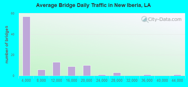
- 768,410Total average daily traffic
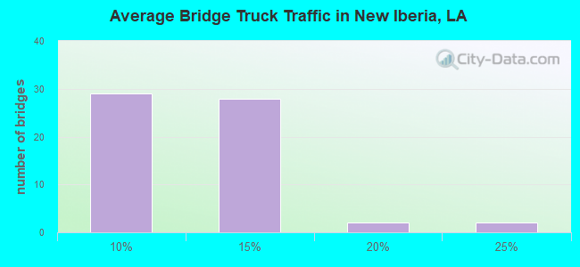
- 68,930Total average daily truck traffic
- National Bridge Inventory (NBI) Registered Bridges for New Iberia
- No street view available for this location
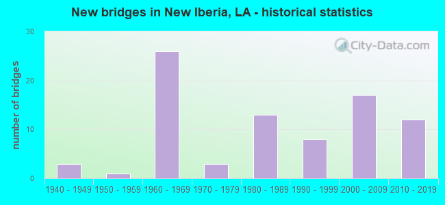
- New bridges - historical statistics
- 31940-1949
- 11950-1959
- 261960-1969
- 31970-1979
- 131980-1989
- 81990-1999
- 172000-2009
- 122010-2019
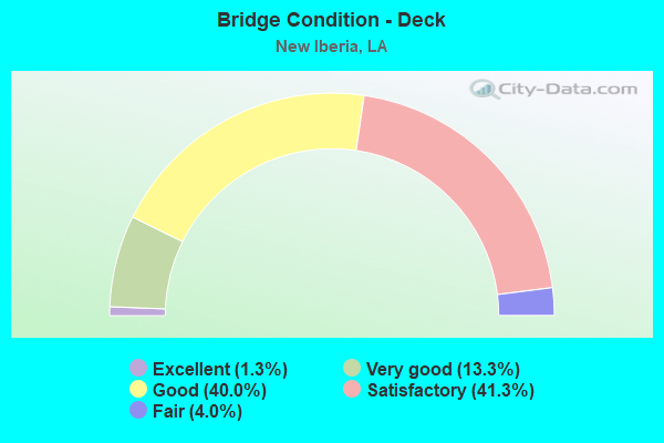
- Bridge Condition - Deck
- 1.3%Excellent
- 13.3%Very good
- 40.0%Good
- 41.3%Satisfactory
- 4.0%Fair
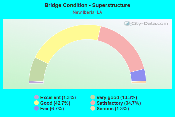
- Bridge Condition - Superstructure
- 1.3%Excellent
- 13.3%Very good
- 42.7%Good
- 34.7%Satisfactory
- 6.7%Fair
- 1.3%Serious
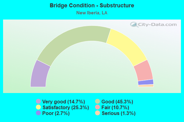
- Bridge Condition - Substructure
- 14.7%Very good
- 45.3%Good
- 25.3%Satisfactory
- 10.7%Fair
- 2.7%Poor
- 1.3%Serious
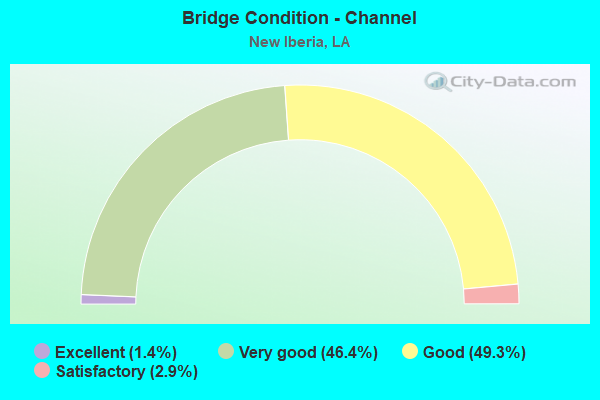
- Bridge Condition - Channel
- 1.4%Excellent
- 46.4%Very good
- 49.3%Good
- 2.9%Satisfactory
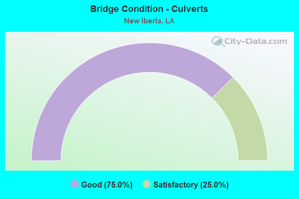
- Bridge Condition - Culverts
- 75.0%Good
- 25.0%Satisfactory
Find on map >> Show street view
Structure Number: 32330008915231, Location: 1.6 Mi. N. of La 675 (Lat: 30.013739, Lng: -91.870689), Route carried "on" structure: County highway , Year Built: 1985, Status: Open, Structure Length: 2.32m (7.61ft), Average Daily Traffic: 56 (year 2020), Average Future Daily Traffic: 24 (year 2036), Design Load: HS 20, Features Intersected: Armenco Branch Canal, Facility Carried by Structure: Leon Landry Rd
Minimum Vertical Clearance: 30+ m (98+ ft), Kilometerpoint: 0.000, Lanes on structure: 2, Owner: County Highway Agency, Approaching Roadway Width: 8.5m (27.9ft), Material/Design: Concrete, Design/Construction: Slab, Number Of Spans In Main Unit: 4, Length of Maximum Span: 5.8m (19.0ft), Curb-To-Curb Width: 7.3m (24.0ft), Out-to-Out Width: 8.2m (26.9ft)
Condition: Deck: Satisfactory, Superstructure: Satisfactory, Substructure: Satisfactory, Channel: Very good, Operating Rating: 47.6 metric tons, Method Used To Determine Operating Rating: Load and Resistance Factor Rating (LRFR) rating reported by rating factor(RF) method using HL-93 loadings, Inventory Rating: 36.6 metric tons, Method Used To Determine Inventory Rating: Load and Resistance Factor Rating (LRFR) rating reported by rating factor(RF) method using HL-93 loadings, Structural Evaluation: Equal to present minimum criteria, Deck Geometry: Equal to present minimum criteria, Waterway Adequacy: Equal to present desirable criteria, Approach Roadway Alignment: Equal to present desirable criteria, Designated Inspection Frequency: Every 24 months, Inspection Date: October 2020, Deck Structure Type: Concrete Precast Panels
Find on map >> Show street view
Structure Number: 32330011915151, Location: 1.0 Mi. NW. of La 674 (Lat: 30.019131, Lng: -91.859000), Route carried "on" structure: County highway , Year Built: 1984, Status: Open, Structure Length: 2.32m (7.61ft), Average Daily Traffic: 289 (year 2020), Average Future Daily Traffic: 36 (year 2036), Design Load: HS 20, Features Intersected: Armenco Branch Canal, Facility Carried by Structure: Landry Rd
Minimum Vertical Clearance: 30+ m (98+ ft), Kilometerpoint: 0.000, Lanes on structure: 2, Owner: County Highway Agency, Approaching Roadway Width: 8.5m (27.9ft), Material/Design: Concrete, Design/Construction: Slab, Number Of Spans In Main Unit: 4, Length of Maximum Span: 5.8m (19.0ft), Curb-To-Curb Width: 7.3m (24.0ft), Out-to-Out Width: 8.2m (26.9ft)
Condition: Deck: Satisfactory, Superstructure: Satisfactory, Substructure: Satisfactory, Channel: Very good, Operating Rating: 47.6 metric tons, Method Used To Determine Operating Rating: Load and Resistance Factor Rating (LRFR) rating reported by rating factor(RF) method using HL-93 loadings, Inventory Rating: 36.6 metric tons, Method Used To Determine Inventory Rating: Load and Resistance Factor Rating (LRFR) rating reported by rating factor(RF) method using HL-93 loadings, Structural Evaluation: Equal to present minimum criteria, Deck Geometry: Somewhat better than minimum adequacy, Waterway Adequacy: Equal to present desirable criteria, Approach Roadway Alignment: Equal to present desirable criteria, Designated Inspection Frequency: Every 24 months, Inspection Date: October 2020, Deck Structure Type: Concrete Precast Panels
Find on map >> Show street view
Structure Number: 32330014915041, Location: 0.5 Mi. SW of La 182 (Lat: 30.017100, Lng: -91.839911), Route carried "on" structure: County highway , Year Built: 1986, Status: Open, Structure Length: 3.05m (10.01ft), Average Daily Traffic: 2,725 (year 2021), Average Future Daily Traffic: 2,998 (year 2041), Design Load: HS 20, Features Intersected: COULEE, Facility Carried by Structure: S. Landry Dr
Minimum Vertical Clearance: 30+ m (98+ ft), Kilometerpoint: 0.000, Lanes on structure: 2, Owner: County Highway Agency, Approaching Roadway Width: 12.2m (40.0ft), Skew: 2 degrees, Material/Design: Concrete, Design/Construction: Slab, Number Of Spans In Main Unit: 5, Length of Maximum Span: 5.8m (19.0ft), Curb-To-Curb Width: 12.3m (40.4ft), Out-to-Out Width: 13.1m (43.0ft)
Condition: Deck: Good, Superstructure: Good, Substructure: Good, Channel: Good, Operating Rating: 70.3 metric tons, Method Used To Determine Operating Rating: Load and Resistance Factor Rating (LRFR) rating reported by rating factor(RF) method using HL-93 loadings, Inventory Rating: 54.1 metric tons, Method Used To Determine Inventory Rating: Load and Resistance Factor Rating (LRFR) rating reported by rating factor(RF) method using HL-93 loadings, Structural Evaluation: Better than present minimum criteria, Deck Geometry: Equal to present minimum criteria, Waterway Adequacy: Equal to present desirable criteria, Approach Roadway Alignment: Equal to present desirable criteria, Designated Inspection Frequency: Every 24 months, Inspection Date: October 2020, Deck Structure Type: Concrete Cast-file-Place
Find on map >> Show street view
Structure Number: 32300000030381, Location: 2.5 MI W OF LA 674 (Lat: 30.002711, Lng: -91.883211), Route carried "under" structure: State highway 675, Structure Length: 0. m, Average Daily Traffic: 2,200 (year 2016), Features Intersected: LA 675 EB UNDER US 90 EB
Minimum Vertical Clearance: 5.79m (19.00ft), Kilometerpoint: 0.303, Lanes on structure: 2, Lanes under structure: 2, Length of Maximum Span: 0.0m
Find on map >> Show street view
Structure Number: 32300000030381, Location: 2.5 MI W OF LA 674 (Lat: 30.002881, Lng: -91.883239), Route carried "under" structure: State highway 675, Structure Length: 0. m, Average Daily Traffic: 2,200 (year 2013), Features Intersected: LA 675 WB UNDER US 90 EB
Minimum Vertical Clearance: 5.70m (18.70ft), Kilometerpoint: 6.257, Lanes on structure: 2, Lanes under structure: 2, Length of Maximum Span: 0.0m
Find on map >> Show street view
Structure Number: 32300000030382, Location: 2.5 MI W OF LA 674 (Lat: 30.002889, Lng: -91.882811), Route carried "under" structure: State highway 675, Structure Length: 0. m, Average Daily Traffic: 2,200 (year 2016), Features Intersected: LA 675 WB UNDER US 90 WB
Minimum Vertical Clearance: 5.79m (19.00ft), Kilometerpoint: 6.215, Lanes on structure: 2, Lanes under structure: 2, Length of Maximum Span: 0.0m
Find on map >> Show street view
Structure Number: 32300000030382, Location: 2.5 MI W OF LA 674 (Lat: 30.002711, Lng: -91.882769), Route carried "under" structure: State highway 675, Structure Length: 0. m, Average Daily Traffic: 2,200 (year 2016), Features Intersected: LA 675 EB UNDER US 90 WB
Minimum Vertical Clearance: 5.70m (18.70ft), Kilometerpoint: 0.346, Lanes on structure: 2, Lanes under structure: 2, Length of Maximum Span: 0.0m
Find on map >> Show street view
Structure Number: 32304240407911, Location: 0.8 MI W OF LA 329 (Lat: 29.985311, Lng: -91.859881), Route carried "under" structure: State highway 14, Structure Length: 0. m, Average Daily Traffic: 10,450 (year 2016), Features Intersected: LA 14 WB UNDER US 90 EB
Minimum Vertical Clearance: 4.57m (14.99ft), Kilometerpoint: 5.013, Lanes on structure: 2, Lanes under structure: 2, Length of Maximum Span: 0.0m
Find on map >> Show street view
Structure Number: 32304240407911, Location: 0.8 MI W OF LA 329 (Lat: 29.985181, Lng: -91.859781), Route carried "under" structure: State highway 14, Structure Length: 0. m, Average Daily Traffic: 10,450 (year 2016), Features Intersected: LA 14 EB UNDER US 90 EB
Minimum Vertical Clearance: 4.48m (14.70ft), Kilometerpoint: 14.080, Lanes on structure: 2, Lanes under structure: 2, Length of Maximum Span: 0.0m
Find on map >> Show street view
Structure Number: 32304240407912, Location: 0.8 MI W OF LA 329 (Lat: 29.985350, Lng: -91.859461), Route carried "under" structure: State highway 14, Structure Length: 0. m, Average Daily Traffic: 10,450 (year 2016), Features Intersected: LA 14 WB UNDER US 90 WB
Minimum Vertical Clearance: 4.51m (14.80ft), Kilometerpoint: 4.973, Lanes on structure: 2, Lanes under structure: 2, Length of Maximum Span: 0.0m
Find on map >> Show street view
Structure Number: 32304240407912, Location: 0.8 MI W OF LA 329 (Lat: 29.985181, Lng: -91.859361), Route carried "under" structure: State highway 14, Structure Length: 0. m, Average Daily Traffic: 10,450 (year 2016), Features Intersected: LA 14 EB UNDER US 90 WB
Minimum Vertical Clearance: 4.48m (14.70ft), Kilometerpoint: 14.120, Lanes on structure: 2, Lanes under structure: 2, Length of Maximum Span: 0.0m
Find on map >> Show street view
Structure Number: 32304240408431, Location: 0.5 MI S OF LA 14 (Lat: 29.979061, Lng: -91.851619), Route carried "under" structure: State highway 329, Structure Length: 0. m, Average Daily Traffic: 1,600 (year 2016), Features Intersected: LA 329 NB UNDER US 90 EB
Minimum Vertical Clearance: 6.80m (22.31ft), Kilometerpoint: 8.866, Lanes on structure: 2, Lanes under structure: 2, Length of Maximum Span: 0.0m
Find on map >> Show street view
Structure Number: 32304240408431, Location: 0.5 MI S OF LA 14 (Lat: 29.980189, Lng: -91.853111), Route carried "under" structure: ServiceUS 90, Structure Length: 0. m, Average Daily Traffic: 3,140 (year 2016), Features Intersected: US 90 FRONTAGE RD UNDER
Minimum Vertical Clearance: 5.33m (17.49ft), Kilometerpoint: 1.099, Lanes on structure: 2, Lanes under structure: 2, Length of Maximum Span: 0.0m
Find on map >> Show street view
Structure Number: 32304240408431, Location: 0.5 MI S OF LA 14 (Lat: 29.979219, Lng: -91.851669), Route carried "under" structure: State highway 329, Structure Length: 0. m, Average Daily Traffic: 1,600 (year 2016), Features Intersected: LA 329 SB UNDER US 90 EB
Minimum Vertical Clearance: 6.83m (22.41ft), Kilometerpoint: 0.856, Lanes on structure: 2, Lanes under structure: 2, Length of Maximum Span: 0.0m
Find on map >> Show street view
Structure Number: 32304240408432, Location: 0.5 MI S OF LA 14 (Lat: 29.979411, Lng: -91.851511), Route carried "under" structure: State highway 329, Structure Length: 0. m, Average Daily Traffic: 1,600 (year 2016), Features Intersected: LA 329 SB UNDER US 90 WB
Minimum Vertical Clearance: 6.80m (22.31ft), Kilometerpoint: 0.829, Lanes on structure: 2, Lanes under structure: 2, Length of Maximum Span: 0.0m
Find on map >> Show street view
Structure Number: 32304240408432, Location: 0.5 MI S OF LA 14 (Lat: 29.979261, Lng: -91.851450), Route carried "under" structure: State highway 329, Structure Length: 0. m, Average Daily Traffic: 1,600 (year 2016), Features Intersected: LA 329 NB UNDER US 90 WB
Minimum Vertical Clearance: 6.77m (22.21ft), Kilometerpoint: 8.893, Lanes on structure: 2, Lanes under structure: 2, Length of Maximum Span: 0.0m
Find on map >> Show street view
Structure Number: 32304240408432, Location: 0.5 MI S OF LA 14 (Lat: 29.980431, Lng: -91.852861), Route carried "under" structure: ServiceUS 90, Structure Length: 0. m, Average Daily Traffic: 3,140 (year 2016), Features Intersected: US 90 FRONTAGE RD UNDER
Minimum Vertical Clearance: 5.36m (17.59ft), Kilometerpoint: 0.032, Lanes on structure: 2, Lanes under structure: 2, Length of Maximum Span: 0.0m
Find on map >> Show street view
Structure Number: 32304240409751, Location: 2.6 MI SE OF LA 14 (Lat: 29.960400, Lng: -91.821631), Route carried "under" structure: State highway 83, Structure Length: 0. m, Average Daily Traffic: 1,900 (year 2016), Features Intersected: LA 83 SB UNDER US 90 EB
Minimum Vertical Clearance: 5.21m (17.09ft), Kilometerpoint: 4.167, Lanes on structure: 2, Lanes under structure: 2, Length of Maximum Span: 0.0m
Find on map >> Show street view
Structure Number: 32304240409751, Location: 2.6 MI SE OF LA 14 (Lat: 29.960219, Lng: -91.821461), Route carried "under" structure: State highway 83, Structure Length: 0. m, Average Daily Traffic: 1,900 (year 2016), Features Intersected: LA 83 NB UNDER US 90 EB
Minimum Vertical Clearance: 5.33m (17.49ft), Kilometerpoint: 7.303, Lanes under structure: 2, Length of Maximum Span: 0.0m
Find on map >> Show street view
Structure Number: 32304240409752, Location: 2.6 MI SE OF LA 14 (Lat: 29.960650, Lng: -91.821550), Route carried "under" structure: State highway 83, Structure Length: 0. m, Average Daily Traffic: 1,900 (year 2016), Features Intersected: LA 83 SB UNDER US 90 WB
Minimum Vertical Clearance: 5.21m (17.09ft), Kilometerpoint: 4.138, Lanes on structure: 2, Lanes under structure: 2, Length of Maximum Span: 0.0m
Find on map >> Show street view
Structure Number: 32304240409752, Location: 2.6 MI SE OF LA 14 (Lat: 29.960461, Lng: -91.821369), Route carried "under" structure: State highway 83, Structure Length: 0. m, Average Daily Traffic: 1,900 (year 2016), Features Intersected: LA 83 NB UNDER US 90 WB
Minimum Vertical Clearance: 5.30m (17.39ft), Kilometerpoint: 7.331, Lanes on structure: 2, Lanes under structure: 2, Length of Maximum Span: 0.0m