Bridge Statistics for New Iberia, Louisiana (LA)
Condition, Traffic, Stress, Structural Evaluation, Project Costs
- National Bridge Inventory (NBI) Statistics
- 101Number of bridges
- 3,146ft / 959mTotal length
- $21,384,000Total costs
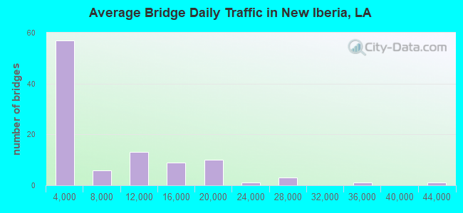
- 768,410Total average daily traffic
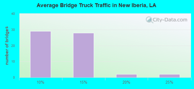
- 68,930Total average daily truck traffic
- National Bridge Inventory (NBI) Registered Bridges for New Iberia
- No street view available for this location
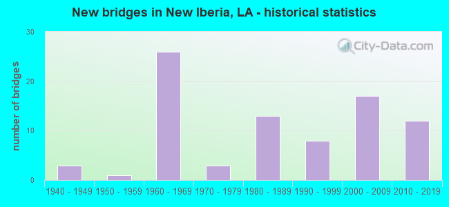
- New bridges - historical statistics
- 31940-1949
- 11950-1959
- 261960-1969
- 31970-1979
- 131980-1989
- 81990-1999
- 172000-2009
- 122010-2019
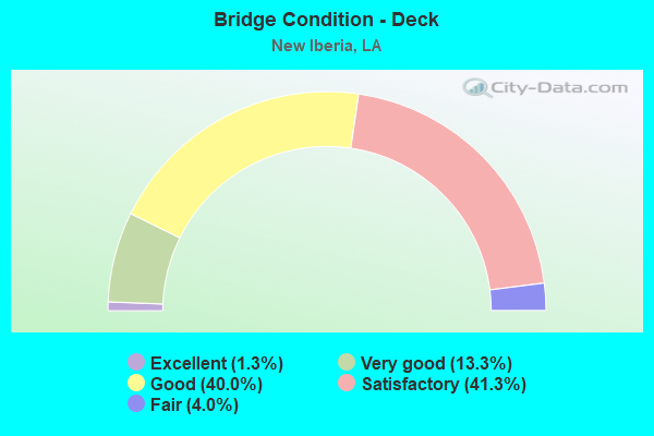
- Bridge Condition - Deck
- 1.3%Excellent
- 13.3%Very good
- 40.0%Good
- 41.3%Satisfactory
- 4.0%Fair
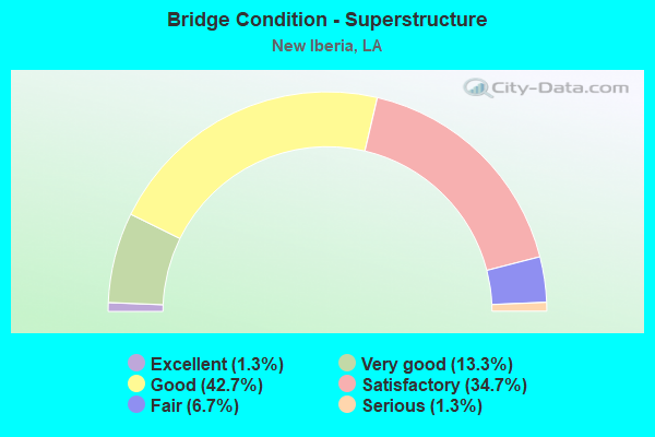
- Bridge Condition - Superstructure
- 1.3%Excellent
- 13.3%Very good
- 42.7%Good
- 34.7%Satisfactory
- 6.7%Fair
- 1.3%Serious
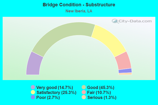
- Bridge Condition - Substructure
- 14.7%Very good
- 45.3%Good
- 25.3%Satisfactory
- 10.7%Fair
- 2.7%Poor
- 1.3%Serious
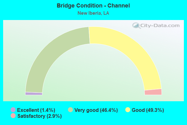
- Bridge Condition - Channel
- 1.4%Excellent
- 46.4%Very good
- 49.3%Good
- 2.9%Satisfactory
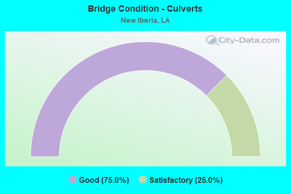
- Bridge Condition - Culverts
- 75.0%Good
- 25.0%Satisfactory
Find on map >> Show street view
Structure Number: 32304240408432, Location: 2.38 Mi W of LA 83 (Lat: 29.978200, Lng: -91.850000), Route carried "on" structure: US 90, Year Built: 1969, Year Reconstructed: 2006, Status: Open, Structure Length: 42.73m (140.19ft), Average Daily Traffic: 18,564 (year 2020), Truck Traffic: 10%, Average Future Daily Traffic: 20,420 (year 2040), Design Load: HS 20, Features Intersected: LA 329 & LDRR
Minimum Vertical Clearance: 30+ m (98+ ft), Kilometerpoint: 19.824, Lanes on structure: 2, Lanes under structure: 4, Base Highway Network: Yes (Inventory Route: 424-04-2, Subroute: 10), Owner: State Highway Agency, Approaching Roadway Width: 11.6m (38.1ft), Skew: 10 degrees, Material/Design: Prestressed concrete, Design/Construction: Stringer/Multi-beam, Number Of Spans In Main Unit: 20, Length of Maximum Span: 21.3m (69.9ft), Curb-To-Curb Width: 8.7m (28.5ft), Out-to-Out Width: 10.1m (33.1ft)
Condition: Deck: Good, Superstructure: Good, Substructure: Satisfactory, Operating Rating: 60.9 metric tons, Method Used To Determine Operating Rating: Load and Resistance Factor Rating (LRFR) rating reported by rating factor(RF) method using HL-93 loadings, Inventory Rating: 31.8 metric tons, Method Used To Determine Inventory Rating: Load and Resistance Factor Rating (LRFR) rating reported by rating factor(RF) method using HL-93 loadings, Structural Evaluation: Equal to present minimum criteria, Deck Geometry: High priority of corrective action, Underclear: Somewhat better than minimum adequacy, Approach Roadway Alignment: Equal to present desirable criteria, Length Of Structure Improvement: 42.73m (140.19ft), Designated Inspection Frequency: Every 24 months, Inspection Date: March 2021, Bridge Improvement Cost: $3,645,000, Total Project Cost: $5,467,000 ( Estimate for 2016), Deck Structure Type: Concrete Cast-file-Place, Wearing Surface/Protective System: Wearing Surface: Epoxy Overlay
Find on map >> Show street view
Structure Number: 32304240409161, Location: 0.56 Mi E of LA 329 (Lat: 29.973761, Lng: -91.844500), Route carried "on" structure: US 90, Year Built: 1969, Status: Open, Structure Length: 3.05m (10.01ft), Average Daily Traffic: 15,700 (year 2016), Truck Traffic: 10%, Average Future Daily Traffic: 11,160 (year 2036), Design Load: HS 20, Features Intersected: RODERE CANAL
Minimum Vertical Clearance: 30+ m (98+ ft), Kilometerpoint: 14.751, Lanes on structure: 2, Base Highway Network: Yes (Inventory Route: 424-04-1, Subroute: 10), Owner: State Highway Agency, Approaching Roadway Width: 12.2m (40.0ft), Skew: 10 degrees, Material/Design: Concrete, Design/Construction: Slab, Number Of Spans In Main Unit: 4, Length of Maximum Span: 7.6m (24.9ft), Curb-To-Curb Width: 12.2m (40.0ft), Out-to-Out Width: 12.7m (41.7ft)
Condition: Deck: Satisfactory, Superstructure: Satisfactory, Substructure: Satisfactory, Channel: Very good, Operating Rating: 46.0 metric tons, Method Used To Determine Operating Rating: Load and Resistance Factor Rating (LRFR) rating reported by rating factor(RF) method using HL-93 loadings, Inventory Rating: 35.6 metric tons, Method Used To Determine Inventory Rating: Load and Resistance Factor Rating (LRFR) rating reported by rating factor(RF) method using HL-93 loadings, Structural Evaluation: Equal to present minimum criteria, Deck Geometry: Better than present minimum criteria, Waterway Adequacy: Equal to present desirable criteria, Approach Roadway Alignment: Equal to present desirable criteria, Designated Inspection Frequency: Every 24 months, Inspection Date: September 2020, Deck Structure Type: Concrete Cast-file-Place
Find on map >> Show street view
Structure Number: 32304240409162, Location: 1.68 Mi W of LA 83 (Lat: 29.973800, Lng: -91.844100), Route carried "on" structure: US 90, Year Built: 1969, Status: Open, Structure Length: 3.05m (10.01ft), Average Daily Traffic: 15,700 (year 2016), Truck Traffic: 10%, Average Future Daily Traffic: 11,160 (year 2036), Design Load: HS 20, Features Intersected: RODERE CANAL
Minimum Vertical Clearance: 30+ m (98+ ft), Kilometerpoint: 19.077, Lanes on structure: 2, Base Highway Network: Yes (Inventory Route: 424-04-2, Subroute: 10), Owner: State Highway Agency, Approaching Roadway Width: 12.2m (40.0ft), Skew: 10 degrees, Material/Design: Concrete, Design/Construction: Slab, Number Of Spans In Main Unit: 4, Length of Maximum Span: 7.6m (24.9ft), Curb-To-Curb Width: 12.2m (40.0ft), Out-to-Out Width: 12.7m (41.7ft)
Condition: Deck: Satisfactory, Superstructure: Satisfactory, Substructure: Satisfactory, Channel: Very good, Operating Rating: 74.4 metric tons, Method Used To Determine Operating Rating: Load Factor (LF), Inventory Rating: 44.4 metric tons, Method Used To Determine Inventory Rating: Load Factor (LF), Structural Evaluation: Equal to present minimum criteria, Deck Geometry: Better than present minimum criteria, Waterway Adequacy: Equal to present desirable criteria, Approach Roadway Alignment: Equal to present desirable criteria, Designated Inspection Frequency: Every 24 months, Inspection Date: September 2020, Deck Structure Type: Concrete Cast-file-Place
Find on map >> Show street view
Structure Number: 32304240409163, Location: 0.57 Mi E of LA 329 (Lat: 29.973589, Lng: -91.844600), Route carried "on" structure: ServiceUS 90, Year Built: 1999, Status: Open, Structure Length: 3.05m (10.01ft), Average Daily Traffic: 1,856 (year 2020), Truck Traffic: 9%, Average Future Daily Traffic: 2,041 (year 2040), Design Load: HS 20, Features Intersected: RODERE COULEE
Minimum Vertical Clearance: 30+ m (98+ ft), Kilometerpoint: 0.930, Lanes on structure: 2, Owner: State Highway Agency, Approaching Roadway Width: 6.9m (22.6ft), Skew: 8 degrees, Material/Design: Concrete, Design/Construction: Slab, Number Of Spans In Main Unit: 5, Length of Maximum Span: 6.1m (20.0ft), Curb-To-Curb Width: 9.1m (29.9ft), Out-to-Out Width: 10.1m (33.1ft)
Condition: Deck: Good, Superstructure: Good, Substructure: Good, Channel: Good, Operating Rating: 67.1 metric tons, Method Used To Determine Operating Rating: Load Factor (LF), Inventory Rating: 39.9 metric tons, Method Used To Determine Inventory Rating: Load Factor (LF), Structural Evaluation: Better than present minimum criteria, Deck Geometry: Somewhat better than minimum adequacy, Waterway Adequacy: Equal to present desirable criteria, Approach Roadway Alignment: Equal to present desirable criteria, Designated Inspection Frequency: Every 24 months, Underwater Inspection Frequency: Every 60 months, Inspection Date: August 2021, Underwater Inspection Date: August 2018, Deck Structure Type: Concrete Cast-file-Place, Wearing Surface/Protective System: Wearing Surface: Wood or Timber
Find on map >> Show street view
Structure Number: 32304240409164, Location: 0.6 Mi E of LA 329 (Lat: 29.973961, Lng: -91.844000), Route carried "on" structure: ServiceUS 90, Year Built: 1999, Status: Open, Structure Length: 3.05m (10.01ft), Average Daily Traffic: 1,856 (year 2020), Truck Traffic: 9%, Average Future Daily Traffic: 2,041 (year 2040), Design Load: HS 20, Features Intersected: RODERE CANAL
Minimum Vertical Clearance: 30+ m (98+ ft), Kilometerpoint: 0.781, Lanes on structure: 2, Owner: State Highway Agency, Approaching Roadway Width: 6.7m (22.0ft), Skew: 8 degrees, Material/Design: Concrete, Design/Construction: Slab, Number Of Spans In Main Unit: 5, Length of Maximum Span: 6.1m (20.0ft), Curb-To-Curb Width: 9.1m (29.9ft), Out-to-Out Width: 9.8m (32.2ft)
Condition: Deck: Satisfactory, Superstructure: Satisfactory, Substructure: Satisfactory, Channel: Good, Operating Rating: 67.1 metric tons, Method Used To Determine Operating Rating: Load Factor (LF), Inventory Rating: 39.9 metric tons, Method Used To Determine Inventory Rating: Load Factor (LF), Structural Evaluation: Equal to present minimum criteria, Deck Geometry: Somewhat better than minimum adequacy, Waterway Adequacy: Equal to present desirable criteria, Approach Roadway Alignment: Equal to present desirable criteria, Designated Inspection Frequency: Every 24 months, Underwater Inspection Frequency: Every 60 months, Inspection Date: August 2021, Underwater Inspection Date: August 2018, Deck Structure Type: Concrete Cast-file-Place, Wearing Surface/Protective System: Wearing Surface: Wood or Timber
Find on map >> Show street view
Structure Number: 32304240409661, Location: 1.09 Mi E of LA 329 (Lat: 29.968750, Lng: -91.837800), Route carried "on" structure: US 90, Year Built: 2000, Status: Open, Structure Length: 44.26m (145.21ft), Average Daily Traffic: 15,700 (year 2016), Truck Traffic: 10%, Average Future Daily Traffic: 11,160 (year 2036), Design Load: HS 20, Features Intersected: LEWIS STREET
Minimum Vertical Clearance: 30+ m (98+ ft), Kilometerpoint: 15.606, Lanes on structure: 2, Lanes under structure: 4, Base Highway Network: Yes (Inventory Route: 424-04-1, Subroute: 10), Owner: State Highway Agency, Approaching Roadway Width: 7.3m (24.0ft), Skew: 5 degrees, Material/Design: Prestressed concrete, Design/Construction: Stringer/Multi-beam, Number Of Spans In Main Unit: 17, Length of Maximum Span: 42.1m (138.1ft), Curb-To-Curb Width: 12.2m (40.0ft), Out-to-Out Width: 13.0m (42.7ft)
Condition: Deck: Satisfactory, Superstructure: Good, Substructure: Satisfactory, Channel: Good, Operating Rating: 58.0 metric tons, Method Used To Determine Operating Rating: Load Factor (LF), Inventory Rating: 34.5 metric tons, Method Used To Determine Inventory Rating: Load Factor (LF), Structural Evaluation: Equal to present minimum criteria, Deck Geometry: Better than present minimum criteria, Waterway Adequacy: Equal to present desirable criteria, Approach Roadway Alignment: Equal to present desirable criteria, Designated Inspection Frequency: Every 24 months, Inspection Date: June 2020, Deck Structure Type: Concrete Cast-file-Place
Find on map >> Show street view
Structure Number: 32304240409662, Location: 1.15 Mi W of LA 83 (Lat: 29.966469, Lng: -91.834300), Route carried "on" structure: US 90, Year Built: 2000, Status: Open, Structure Length: 44.26m (145.21ft), Average Daily Traffic: 15,700 (year 2016), Truck Traffic: 10%, Average Future Daily Traffic: 11,160 (year 2036), Design Load: HS 20, Features Intersected: LEWIS STREET
Minimum Vertical Clearance: 30+ m (98+ ft), Kilometerpoint: 17.827, Lanes on structure: 2, Lanes under structure: 4, Base Highway Network: Yes (Inventory Route: 424-04-2, Subroute: 10), Owner: State Highway Agency, Approaching Roadway Width: 7.3m (24.0ft), Skew: 5 degrees, Material/Design: Prestressed concrete, Design/Construction: Stringer/Multi-beam, Number Of Spans In Main Unit: 17, Length of Maximum Span: 42.1m (138.1ft), Curb-To-Curb Width: 12.2m (40.0ft), Out-to-Out Width: 13.0m (42.7ft)
Condition: Deck: Good, Superstructure: Good, Substructure: Satisfactory, Channel: Good, Operating Rating: 55.3 metric tons, Method Used To Determine Operating Rating: Load Factor (LF), Inventory Rating: 33.6 metric tons, Method Used To Determine Inventory Rating: Load Factor (LF), Structural Evaluation: Equal to present minimum criteria, Deck Geometry: Better than present minimum criteria, Waterway Adequacy: Equal to present desirable criteria, Approach Roadway Alignment: Equal to present desirable criteria, Designated Inspection Frequency: Every 24 months, Inspection Date: June 2020, Deck Structure Type: Concrete Cast-file-Place
Find on map >> Show street view
Structure Number: 32304240409751, Location: US 90 OVER LA 83 (Lat: 29.961311, Lng: -91.824200), Route carried "on" structure: US 90, Year Built: 2004, Status: Open, Structure Length: 57.18m (187.60ft), Average Daily Traffic: 12,900 (year 2016), Truck Traffic: 10%, Average Future Daily Traffic: 15,240 (year 2036), Design Load: HS 20, Features Intersected: LA0083
Minimum Vertical Clearance: 30+ m (98+ ft), Kilometerpoint: 17.165, Lanes on structure: 2, Lanes under structure: 5, Base Highway Network: Yes (Inventory Route: 424-04-1, Subroute: 10), Owner: State Highway Agency, Approaching Roadway Width: 11.6m (38.1ft), Skew: 10 degrees, Material/Design: Concrete, Design/Construction: Tee Beam, Number Of Spans In Main Unit: 26, Length of Maximum Span: 33.5m (109.9ft), Curb-To-Curb Width: 12.2m (40.0ft), Out-to-Out Width: 13.0m (42.7ft)
Condition: Deck: Good, Superstructure: Good, Substructure: Very good, Operating Rating: 48.6 metric tons, Method Used To Determine Operating Rating: Load and Resistance Factor Rating (LRFR) rating reported by rating factor(RF) method using HL-93 loadings, Inventory Rating: 26.6 metric tons, Method Used To Determine Inventory Rating: Load and Resistance Factor Rating (LRFR) rating reported by rating factor(RF) method using HL-93 loadings, Structural Evaluation: Equal to present minimum criteria, Deck Geometry: Better than present minimum criteria, Underclear: Superior to present desirable criteria, Approach Roadway Alignment: Equal to present desirable criteria, Designated Inspection Frequency: Every 24 months, Inspection Date: December 2020, Deck Structure Type: Concrete Cast-file-Place
Find on map >> Show street view
Structure Number: 32304240409752, Location: US 90 OVER LA 83 (Lat: 29.959461, Lng: -91.818600), Route carried "on" structure: US 90, Year Built: 2004, Status: Open, Structure Length: 57.18m (187.60ft), Average Daily Traffic: 12,900 (year 2016), Truck Traffic: 10%, Average Future Daily Traffic: 15,240 (year 2036), Design Load: HS 20, Features Intersected: LA0083
Minimum Vertical Clearance: 30+ m (98+ ft), Kilometerpoint: 16.124, Lanes on structure: 2, Lanes under structure: 5, Base Highway Network: Yes (Inventory Route: 424-04-2, Subroute: 10), Owner: State Highway Agency, Approaching Roadway Width: 11.6m (38.1ft), Skew: 10 degrees, Material/Design: Concrete, Design/Construction: Tee Beam, Number Of Spans In Main Unit: 26, Length of Maximum Span: 33.5m (109.9ft), Curb-To-Curb Width: 12.2m (40.0ft), Out-to-Out Width: 13.0m (42.7ft)
Condition: Deck: Good, Superstructure: Good, Substructure: Good, Operating Rating: 82.5 metric tons, Method Used To Determine Operating Rating: Load Factor (LF), Inventory Rating: 45.4 metric tons, Method Used To Determine Inventory Rating: Load Factor (LF), Structural Evaluation: Better than present minimum criteria, Deck Geometry: Better than present minimum criteria, Underclear: Superior to present desirable criteria, Approach Roadway Alignment: Equal to present desirable criteria, Designated Inspection Frequency: Every 24 months, Inspection Date: December 2020, Deck Structure Type: Concrete Cast-file-Place
Find on map >> Show street view
Structure Number: 32304240409823, Location: 1.37 MI E of LA 329 (Lat: 29.964811, Lng: -91.836800), Route carried "on" structure: ServiceUS 90, Year Built: 1999, Status: Open, Structure Length: 3.05m (10.01ft), Average Daily Traffic: 1,856 (year 2020), Truck Traffic: 9%, Average Future Daily Traffic: 2,041 (year 2040), Design Load: HS 20, Features Intersected: COMMERCIAL CANAL
Minimum Vertical Clearance: 30+ m (98+ ft), Kilometerpoint: 2.210, Lanes on structure: 2, Owner: State Highway Agency, Approaching Roadway Width: 7.0m (23.0ft), Material/Design: Concrete, Design/Construction: Slab, Number Of Spans In Main Unit: 5, Length of Maximum Span: 6.1m (20.0ft), Curb-To-Curb Width: 9.1m (29.9ft), Out-to-Out Width: 9.8m (32.2ft)
Condition: Deck: Satisfactory, Superstructure: Satisfactory, Substructure: Satisfactory, Channel: Very good, Operating Rating: 63.5 metric tons, Method Used To Determine Operating Rating: Load Factor (LF), Inventory Rating: 38.1 metric tons, Method Used To Determine Inventory Rating: Load Factor (LF), Structural Evaluation: Equal to present minimum criteria, Deck Geometry: Somewhat better than minimum adequacy, Waterway Adequacy: Equal to present desirable criteria, Approach Roadway Alignment: High priority of corrective action, Length Of Structure Improvement: 3.90m (12.80ft), Designated Inspection Frequency: Every 24 months, Inspection Date: August 2021, Bridge Improvement Cost: $332,000, Total Project Cost: $498,000 ( Estimate for 2016), Deck Structure Type: Concrete Cast-file-Place, Wearing Surface/Protective System: Wearing Surface: Wood or Timber
Find on map >> Show street view
Structure Number: 32304240409826, Location: 1.10 Mi W of LA 83 (Lat: 29.968811, Lng: -91.836400), Route carried "on" structure: Ramp US 90, Year Built: 1999, Status: Open, Structure Length: 3.66m (12.01ft), Average Daily Traffic: 2,860 (year 2018), Truck Traffic: 10%, Average Future Daily Traffic: 3,146 (year 2036), Design Load: HS 20, Features Intersected: NEW IBERIA SOUTHERN CANA
Minimum Vertical Clearance: 30+ m (98+ ft), Kilometerpoint: 0.063, Lanes on structure: 2, Owner: State Highway Agency, Approaching Roadway Width: 7.6m (24.9ft), Skew: 6 degrees, Material/Design: Concrete, Design/Construction: Slab, Number Of Spans In Main Unit: 6, Length of Maximum Span: 6.1m (20.0ft), Curb-To-Curb Width: 7.6m (24.9ft), Out-to-Out Width: 8.3m (27.2ft)
Condition: Deck: Satisfactory, Superstructure: Satisfactory, Substructure: Poor, Channel: Very good, Operating Rating: 67.1 metric tons, Method Used To Determine Operating Rating: Load Factor (LF), Inventory Rating: 39.9 metric tons, Method Used To Determine Inventory Rating: Load Factor (LF), Structural Evaluation: Meets minimum limits, Deck Geometry: High priority of replacement, Waterway Adequacy: Equal to present desirable criteria, Approach Roadway Alignment: Equal to present minimum criteria, Length Of Structure Improvement: 4.57m (14.99ft), Designated Inspection Frequency: Every 12 months, Inspection Date: August 2021, Bridge Improvement Cost: $390,000, Total Project Cost: $585,000 ( Estimate for 2016), Deck Structure Type: Concrete Cast-file-Place, Wearing Surface/Protective System: Wearing Surface: Wood or Timber
Find on map >> Show street view
Structure Number: 32304240409827, Location: 1.27 Mi E of LA 329 (Lat: 29.966411, Lng: -91.836800), Route carried "on" structure: Ramp US 90, Year Built: 1999, Status: Open, Structure Length: 3.05m (10.01ft), Average Daily Traffic: 2,860 (year 2018), Truck Traffic: 10%, Average Future Daily Traffic: 3,146 (year 2036), Design Load: HS 20, Features Intersected: NEW IBERIA SOUTHERN CANA
Minimum Vertical Clearance: 30+ m (98+ ft), Kilometerpoint: 0.624, Lanes on structure: 2, Owner: State Highway Agency, Approaching Roadway Width: 7.8m (25.6ft), Skew: 7 degrees, Material/Design: Concrete, Design/Construction: Slab, Number Of Spans In Main Unit: 5, Length of Maximum Span: 6.1m (20.0ft), Curb-To-Curb Width: 7.4m (24.3ft), Out-to-Out Width: 8.5m (27.9ft)
Condition: Deck: Satisfactory, Superstructure: Satisfactory, Substructure: Poor, Channel: Very good, Operating Rating: 67.1 metric tons, Method Used To Determine Operating Rating: Load Factor (LF), Inventory Rating: 39.9 metric tons, Method Used To Determine Inventory Rating: Load Factor (LF), Structural Evaluation: Meets minimum limits, Deck Geometry: High priority of replacement, Waterway Adequacy: Equal to present desirable criteria, Approach Roadway Alignment: Equal to present desirable criteria, Length Of Structure Improvement: 3.90m (12.80ft), Designated Inspection Frequency: Every 12 months, Inspection Date: August 2021, Bridge Improvement Cost: $332,000, Total Project Cost: $498,000 ( Estimate for 2016), Deck Structure Type: Concrete Cast-file-Place, Wearing Surface/Protective System: Wearing Surface: Wood or Timber
Find on map >> Show street view
Structure Number: 32304240411331, Location: 0.40 Mi E of LA 83 (Lat: 29.957731, Lng: -91.815300), Route carried "on" structure: US 90, Year Built: 1969, Status: Open, Structure Length: 1.34m (4.40ft), Average Daily Traffic: 25,800 (year 2016), Truck Traffic: 10%, Average Future Daily Traffic: 15,240 (year 2036), Design Load: HS 20, Features Intersected: DUBOIN CANAL
Minimum Vertical Clearance: 30+ m (98+ ft), Kilometerpoint: 18.113, Lanes on structure: 8, Base Highway Network: Yes (Inventory Route: 424-04-1, Subroute: 10), Owner: State Highway Agency, Approaching Roadway Width: 34.7m (113.8ft), Skew: 14 degrees, Material/Design: Concrete, Design/Construction: Culvert, Number Of Spans In Main Unit: 5, Length of Maximum Span: 2.1m (6.9ft), Curb-To-Curb Width: 34.7m (113.8ft), Out-to-Out Width: 73.0m (239.5ft)
Condition: Channel: Good, Culverts: Good, Operating Rating: 70.6 metric tons, Method Used To Determine Operating Rating: Load and Resistance Factor Rating (LRFR) rating reported by rating factor(RF) method using HL-93 loadings, Inventory Rating: 54.4 metric tons, Method Used To Determine Inventory Rating: Load and Resistance Factor Rating (LRFR) rating reported by rating factor(RF) method using HL-93 loadings, Structural Evaluation: Better than present minimum criteria, Deck Geometry: Better than present minimum criteria, Waterway Adequacy: Equal to present desirable criteria, Approach Roadway Alignment: Equal to present desirable criteria, Designated Inspection Frequency: Every 24 months, Underwater Inspection Frequency: Every 60 months, Inspection Date: September 2020, Underwater Inspection Date: October 2018, Deck Structure Type: Concrete Cast-file-Place
Find on map >> Show street view
Structure Number: 32304240413911, Location: 3.08 MI E of LA 83 (Lat: 29.942639, Lng: -91.774300), Route carried "on" structure: US 90, Year Built: 2002, Status: Open, Structure Length: 57.49m (188.62ft), Average Daily Traffic: 11,850 (year 2016), Truck Traffic: 10%, Average Future Daily Traffic: 13,980 (year 2036), Design Load: HS 20, Features Intersected: Darnell Rd
Minimum Vertical Clearance: 30+ m (98+ ft), Kilometerpoint: 22.409, Lanes on structure: 2, Lanes under structure: 5, Base Highway Network: Yes (Inventory Route: 424-04-1, Subroute: 10), Owner: State Highway Agency, Approaching Roadway Width: 7.3m (24.0ft), Skew: 10 degrees, Material/Design: Prestressed concrete, Design/Construction: Stringer/Multi-beam, Number Of Spans In Main Unit: 28, Length of Maximum Span: 21.3m (69.9ft), Curb-To-Curb Width: 12.2m (40.0ft), Out-to-Out Width: 13.0m (42.7ft)
Condition: Deck: Good, Superstructure: Very good, Substructure: Very good, Operating Rating: 33.7 metric tons, Method Used To Determine Operating Rating: Load and Resistance Factor Rating (LRFR) rating reported by rating factor(RF) method using HL-93 loadings, Inventory Rating: 25.9 metric tons, Method Used To Determine Inventory Rating: Load and Resistance Factor Rating (LRFR) rating reported by rating factor(RF) method using HL-93 loadings, Structural Evaluation: Equal to present minimum criteria, Deck Geometry: Better than present minimum criteria, Underclear: Superior to present desirable criteria, Approach Roadway Alignment: Equal to present desirable criteria, Designated Inspection Frequency: Every 24 months, Inspection Date: May 2020, Deck Structure Type: Concrete Cast-file-Place
Find on map >> Show street view
Structure Number: 32304240413912, Location: 3.20 MI W of LA 85 (Lat: 29.940889, Lng: -91.768700), Route carried "on" structure: US 90, Year Built: 2002, Status: Open, Structure Length: 57.49m (188.62ft), Average Daily Traffic: 11,850 (year 2016), Truck Traffic: 10%, Average Future Daily Traffic: 13,980 (year 2036), Design Load: HS 20, Features Intersected: Darnell Rd
Minimum Vertical Clearance: 30+ m (98+ ft), Kilometerpoint: 10.879, Lanes on structure: 2, Lanes under structure: 5, Base Highway Network: Yes (Inventory Route: 424-04-2, Subroute: 10), Owner: State Highway Agency, Approaching Roadway Width: 7.3m (24.0ft), Skew: 10 degrees, Material/Design: Prestressed concrete, Design/Construction: Stringer/Multi-beam, Number Of Spans In Main Unit: 28, Length of Maximum Span: 21.3m (69.9ft), Curb-To-Curb Width: 12.2m (40.0ft), Out-to-Out Width: 13.0m (42.7ft)
Condition: Deck: Good, Superstructure: Very good, Substructure: Very good, Operating Rating: 33.7 metric tons, Method Used To Determine Operating Rating: Load and Resistance Factor Rating (LRFR) rating reported by rating factor(RF) method using HL-93 loadings, Inventory Rating: 25.9 metric tons, Method Used To Determine Inventory Rating: Load and Resistance Factor Rating (LRFR) rating reported by rating factor(RF) method using HL-93 loadings, Structural Evaluation: Equal to present minimum criteria, Deck Geometry: Better than present minimum criteria, Underclear: Superior to present desirable criteria, Approach Roadway Alignment: Equal to present desirable criteria, Designated Inspection Frequency: Every 24 months, Inspection Date: May 2020, Deck Structure Type: Concrete Cast-file-Place
Find on map >> Show street view
Structure Number: 32308230208181, Location: 0.4 MI EAST OF US 90 (Lat: 29.999731, Lng: -91.875600), Route carried "on" structure: State highway 675, Year Built: 1960, Status: Open, Structure Length: 1.83m (6.00ft), Average Daily Traffic: 8,700 (year 2016), Truck Traffic: 9%, Average Future Daily Traffic: 5,220 (year 2036), Design Load: HS 20, Features Intersected: ARMENCO CANAL
Minimum Vertical Clearance: 30+ m (98+ ft), Kilometerpoint: 1.167, Lanes on structure: 2, Owner: State Highway Agency, Approaching Roadway Width: 11.9m (39.0ft), Material/Design: Concrete, Design/Construction: Slab, Number Of Spans In Main Unit: 3, Length of Maximum Span: 6.1m (20.0ft), Curb-To-Curb Width: 7.3m (24.0ft), Out-to-Out Width: 8.7m (28.5ft)
Condition: Deck: Satisfactory, Superstructure: Satisfactory, Substructure: Satisfactory, Channel: Good, Operating Rating: 39.0 metric tons, Method Used To Determine Operating Rating: Load Factor (LF), Inventory Rating: 23.6 metric tons, Method Used To Determine Inventory Rating: Load Factor (LF), Structural Evaluation: Somewhat better than minimum adequacy, Deck Geometry: High priority of replacement, Waterway Adequacy: Equal to present minimum criteria, Approach Roadway Alignment: High priority of corrective action, Length Of Structure Improvement: 2.56m (8.40ft), Designated Inspection Frequency: Every 24 months, Inspection Date: August 2020, Bridge Improvement Cost: $218,000, Total Project Cost: $327,000 ( Estimate for 2016), Deck Structure Type: Concrete Cast-file-Place
Find on map >> Show street view
Structure Number: 32308230701181, Location: 1.5 MI WEST OF LA 14 (Lat: 29.982911, Lng: -91.913800), Route carried "on" structure: State highway 676, Year Built: 1942, Status: Posted for load, Structure Length: 2.35m (7.71ft), Average Daily Traffic: 730 (year 2016), Truck Traffic: 15%, Average Future Daily Traffic: 450 (year 2036), Design Load: H 10, Features Intersected: DEBLANC COULEE
Minimum Vertical Clearance: 30+ m (98+ ft), Kilometerpoint: 1.852, Lanes on structure: 2, Owner: State Highway Agency, Approaching Roadway Width: 11.0m (36.1ft), Material/Design: Wood or Timber, Design/Construction: Stringer/Multi-beam, Number Of Spans In Main Unit: 4, Length of Maximum Span: 5.8m (19.0ft), Curb-To-Curb Width: 5.8m (19.0ft), Out-to-Out Width: 6.1m (20.0ft)
Condition: Deck: Satisfactory, Superstructure: Satisfactory, Substructure: Fair, Channel: Good, Operating Rating: 23.6 metric tons, Method Used To Determine Operating Rating: Allowable Stress (AS), Inventory Rating: 15.4 metric tons, Method Used To Determine Inventory Rating: Allowable Stress (AS), Structural Evaluation: Meets minimum limits, Deck Geometry: High priority of replacement, Waterway Adequacy: Equal to present minimum criteria, Approach Roadway Alignment: Equal to present desirable criteria, Bridge Posting: Required (Relationship of Operating Rating to Maximum Legal Load: 0.1 - 9.9% below), Length Of Structure Improvement: 3.11m (10.20ft), Designated Inspection Frequency: Every 24 months, Underwater Inspection Frequency: Every 60 months, Inspection Date: August 2020, Underwater Inspection Date: August 2018, Bridge Improvement Cost: $265,000, Total Project Cost: $397,000 ( Estimate for 2016), Deck Structure Type: Wood or Timber, Wearing Surface/Protective System: Wearing Surface: Bituminous
Find on map >> Show street view
Structure Number: 32308230702011, Location: 0.6 MI WEST OF LA 14 (Lat: 29.985039, Lng: -91.900300), Route carried "on" structure: State highway 676, Year Built: 1968, Status: Open, Structure Length: 1.19m (3.90ft), Average Daily Traffic: 730 (year 2016), Truck Traffic: 15%, Average Future Daily Traffic: 450 (year 2036), Design Load: HS 20, Features Intersected: CREEK
Minimum Vertical Clearance: 30+ m (98+ ft), Kilometerpoint: 3.198, Lanes on structure: 2, Owner: State Highway Agency, Approaching Roadway Width: 11.0m (36.1ft), Material/Design: Concrete, Design/Construction: Slab, Number Of Spans In Main Unit: 2, Length of Maximum Span: 5.8m (19.0ft), Curb-To-Curb Width: 7.4m (24.3ft), Out-to-Out Width: 8.3m (27.2ft)
Condition: Deck: Satisfactory, Superstructure: Satisfactory, Substructure: Satisfactory, Channel: Very good, Operating Rating: 43.5 metric tons, Method Used To Determine Operating Rating: Load Factor (LF), Inventory Rating: 26.3 metric tons, Method Used To Determine Inventory Rating: Load Factor (LF), Structural Evaluation: Equal to present minimum criteria, Deck Geometry: Meets minimum limits, Waterway Adequacy: Equal to present desirable criteria, Approach Roadway Alignment: Equal to present desirable criteria, Designated Inspection Frequency: Every 24 months, Inspection Date: June 2020, Deck Structure Type: Concrete Precast Panels
Find on map >> Show street view
Structure Number: 32308231200171, Location: 0.2 Mi. N. of La 182 (Lat: 29.978819, Lng: -91.753900), Route carried "on" structure: State highway 320, Year Built: 1963, Status: Open, Structure Length: 8.02m (26.31ft), Average Daily Traffic: 3,208 (year 2021), Truck Traffic: 9%, Average Future Daily Traffic: 3,529 (year 2041), Design Load: HS 20, Features Intersected: TECHE BAYOU/OLIVIER
Minimum Vertical Clearance: 5.49m (18.01ft), Kilometerpoint: 0.245, Lanes on structure: 2, Owner: State Highway Agency, Approaching Roadway Width: 8.8m (28.9ft), Navigation Control: Yes ( Vertical Clearance: 2.7m (8.9ft), Horizontal Clearance: 15.2m (49.9ft)), Material/Design: Steel, Design/Construction: Movable - Swing, Number Of Spans In Main Unit: 1, Number Of Approach Spans: 4, Length of Maximum Span: 55.8m (183.1ft), Curb-To-Curb Width: 7.3m (24.0ft), Out-to-Out Width: 9.3m (30.5ft)
Condition: Deck: Satisfactory, Superstructure: Serious, Substructure: Good, Channel: Good, Operating Rating: 34.5 metric tons, Method Used To Determine Operating Rating: Allowable Stress (AS), Inventory Rating: 20.9 metric tons, Method Used To Determine Inventory Rating: Allowable Stress (AS), Structural Evaluation: High priority of corrective action, Deck Geometry: High priority of replacement, Waterway Adequacy: Equal to present desirable criteria, Approach Roadway Alignment: Equal to present desirable criteria, Length Of Structure Improvement: 8.93m (29.30ft), Designated Inspection Frequency: Every 24 months, Critical Feature Inspection Frequency: Every 24 months, Underwater Inspection Frequency: Every 60 months, Other Special Inspection Frequency: Every 12 months, Inspection Date: Febuary 2020, Critical Feature Inspection Date: Febuary 2020, Underwater Inspection Date: June 2018, Other Special Inspection Date: Febuary 2021, Bridge Improvement Cost: $761,000, Total Project Cost: $1,141,000 ( Estimate for 2016), Deck Structure Type: Open Grating
Find on map >> Show street view
Structure Number: 32308231201361, Location: 1.36 MI EAST OF LA 87 (Lat: 29.994689, Lng: -91.745800), Route carried "on" structure: State highway 320, Year Built: 1972, Status: Open, Structure Length: 1.74m (5.71ft), Average Daily Traffic: 3,700 (year 2016), Truck Traffic: 9%, Average Future Daily Traffic: 2,220 (year 2036), Design Load: HS 20, Features Intersected: TELE BAYOU
Minimum Vertical Clearance: 30+ m (98+ ft), Kilometerpoint: 2.169, Lanes on structure: 2, Owner: State Highway Agency, Approaching Roadway Width: 10.4m (34.1ft), Material/Design: Concrete, Design/Construction: Slab, Number Of Spans In Main Unit: 3, Length of Maximum Span: 5.8m (19.0ft), Curb-To-Curb Width: 9.8m (32.2ft), Out-to-Out Width: 10.7m (35.1ft)
Condition: Deck: Good, Superstructure: Good, Substructure: Fair, Channel: Satisfactory, Operating Rating: 36.9 metric tons, Method Used To Determine Operating Rating: Load and Resistance Factor Rating (LRFR) rating reported by rating factor(RF) method using HL-93 loadings, Inventory Rating: 28.5 metric tons, Method Used To Determine Inventory Rating: Load and Resistance Factor Rating (LRFR) rating reported by rating factor(RF) method using HL-93 loadings, Structural Evaluation: Somewhat better than minimum adequacy, Deck Geometry: Meets minimum limits, Waterway Adequacy: Equal to present desirable criteria, Approach Roadway Alignment: Equal to present desirable criteria, Designated Inspection Frequency: Every 24 months, Inspection Date: November 2020, Deck Structure Type: Concrete Precast Panels, Wearing Surface/Protective System: Wearing Surface: Bituminous
Find on map >> Show street view
Structure Number: 32308231400251, Location: 0.25 MI NORTH OF LA 86 (Lat: 30.015650, Lng: -91.773900), Route carried "on" structure: State highway 344, Year Built: 1967, Status: Posted for load, Structure Length: 6.89m (22.60ft), Average Daily Traffic: 1,745 (year 2017), Truck Traffic: 9%, Average Future Daily Traffic: 1,920 (year 2037), Design Load: HS 20, Features Intersected: TECHE BAYOU/MORBIHAN
Minimum Vertical Clearance: 5.39m (17.68ft), Kilometerpoint: 0.407, Lanes on structure: 2, Owner: State Highway Agency, Approaching Roadway Width: 11.0m (36.1ft), Navigation Control: Yes ( Vertical Clearance: 2.7m (8.9ft), Horizontal Clearance: 15.2m (49.9ft)), Material/Design: Steel, Design/Construction: Movable - Swing, Number Of Spans In Main Unit: 1, Number Of Approach Spans: 5, Length of Maximum Span: 37.5m (123.0ft), Curb or Sidewalk Widths: Left: 0.9m (3.0ft), Right: 0.9m (3.0ft), Curb-To-Curb Width: 7.4m (24.3ft), Out-to-Out Width: 10.4m (34.1ft)
Condition: Deck: Fair, Superstructure: Fair, Substructure: Good, Channel: Good, Operating Rating: 33.6 metric tons, Method Used To Determine Operating Rating: Allowable Stress (AS), Inventory Rating: 12.7 metric tons, Method Used To Determine Inventory Rating: Allowable Stress (AS), Structural Evaluation: Meets minimum limits, Deck Geometry: Meets minimum limits, Waterway Adequacy: Equal to present desirable criteria, Approach Roadway Alignment: Equal to present minimum criteria, Bridge Posting: Required (Relationship of Operating Rating to Maximum Legal Load: 10.0 - 19.9% below), Designated Inspection Frequency: Every 24 months, Critical Feature Inspection Frequency: Every 24 months, Underwater Inspection Frequency: Every 60 months, Inspection Date: November 2020, Critical Feature Inspection Date: November 2020, Underwater Inspection Date: June 2018, Deck Structure Type: Open Grating
Find on map >> Show street view
Structure Number: 32308232603471, Location: 1.0 MI SOUTH OF LA 344 (Lat: 29.985950, Lng: -91.763800), Route carried "on" structure: State highway 87, Year Built: 1955, Status: Posted for load, Structure Length: 1.77m (5.81ft), Average Daily Traffic: 9,500 (year 2020), Truck Traffic: 9%, Average Future Daily Traffic: 10,450 (year 2040), Design Load: H 15, Features Intersected: CREEK
Minimum Vertical Clearance: 30+ m (98+ ft), Kilometerpoint: 5.557, Lanes on structure: 2, Owner: State Highway Agency, Approaching Roadway Width: 7.4m (24.3ft), Material/Design: Wood or Timber, Design/Construction: Stringer/Multi-beam, Number Of Spans In Main Unit: 3, Length of Maximum Span: 5.8m (19.0ft), Curb-To-Curb Width: 7.8m (25.6ft), Out-to-Out Width: 8.3m (27.2ft)
Condition: Deck: Satisfactory, Superstructure: Satisfactory, Substructure: Fair, Channel: Satisfactory, Operating Rating: 19.0 metric tons, Method Used To Determine Operating Rating: Allowable Stress (AS), Inventory Rating: 11.3 metric tons, Method Used To Determine Inventory Rating: Allowable Stress (AS), Structural Evaluation: High priority of replacement, Deck Geometry: High priority of replacement, Waterway Adequacy: Equal to present desirable criteria, Approach Roadway Alignment: Equal to present minimum criteria, Bridge Posting: Required (Relationship of Operating Rating to Maximum Legal Load: 20.0 - 29.9% below), Length Of Structure Improvement: 2.47m (8.10ft), Designated Inspection Frequency: Every 24 months, Inspection Date: June 2021, Bridge Improvement Cost: $210,000, Total Project Cost: $315,000 ( Estimate for 2016), Deck Structure Type: Wood or Timber, Wearing Surface/Protective System: Wearing Surface: Bituminous
Find on map >> Show street view
Structure Number: 32308232907581, Location: 1.0M SOUTH OF LA 14 (Lat: 29.987219, Lng: -91.824000), Route carried "on" structure: State highway 674, Year Built: 1991, Status: Open, Structure Length: 1.22m (4.00ft), Average Daily Traffic: 19,394 (year 2020), Truck Traffic: 9%, Average Future Daily Traffic: 21,333 (year 2040), Design Load: HS 20, Features Intersected: COMMERCIAL CANAL
Minimum Vertical Clearance: 30+ m (98+ ft), Kilometerpoint: 12.130, Lanes on structure: 4, Owner: State Highway Agency, Approaching Roadway Width: 17.9m (58.7ft), Skew: 26 degrees, Material/Design: Concrete, Design/Construction: Slab, Number Of Spans In Main Unit: 2, Length of Maximum Span: 6.1m (20.0ft), Curb-To-Curb Width: 21.3m (69.9ft), Out-to-Out Width: 22.2m (72.8ft)
Condition: Deck: Satisfactory, Superstructure: Satisfactory, Substructure: Good, Channel: Very good, Operating Rating: 72.6 metric tons, Method Used To Determine Operating Rating: Load Factor (LF), Inventory Rating: 43.5 metric tons, Method Used To Determine Inventory Rating: Load Factor (LF), Structural Evaluation: Equal to present minimum criteria, Deck Geometry: Superior to present desirable criteria, Waterway Adequacy: Equal to present desirable criteria, Approach Roadway Alignment: Equal to present desirable criteria, Designated Inspection Frequency: Every 24 months, Inspection Date: August 2021, Deck Structure Type: Concrete Cast-file-Place
Find on map >> Show street view
Structure Number: 32308233101331, Location: 1.33 MI NORTH OF LA 86 (Lat: 30.076131, Lng: -91.791000), Route carried "on" structure: State highway 680, Year Built: 1971, Status: Open, Structure Length: 0.76m (2.49ft), Average Daily Traffic: 300 (year 2016), Truck Traffic: 9%, Average Future Daily Traffic: 354 (year 2036), Design Load: HS 20, Features Intersected: DRAINAGE CANAL
Minimum Vertical Clearance: 30+ m (98+ ft), Kilometerpoint: 2.213, Lanes on structure: 2, Owner: State Highway Agency, Approaching Roadway Width: 7.6m (24.9ft), Material/Design: Concrete, Design/Construction: Culvert, Number Of Spans In Main Unit: 3, Length of Maximum Span: 2.1m (6.9ft), Out-to-Out Width: 15.9m (52.2ft)
Condition: Channel: Good, Culverts: Good, Operating Rating: 42.1 metric tons, Method Used To Determine Operating Rating: Load and Resistance Factor Rating (LRFR) rating reported by rating factor(RF) method using HL-93 loadings, Inventory Rating: 32.4 metric tons, Method Used To Determine Inventory Rating: Load and Resistance Factor Rating (LRFR) rating reported by rating factor(RF) method using HL-93 loadings, Structural Evaluation: Better than present minimum criteria, Waterway Adequacy: Equal to present desirable criteria, Approach Roadway Alignment: Equal to present minimum criteria, Designated Inspection Frequency: Every 24 months, Inspection Date: August 2021, Deck Structure Type: Concrete Cast-file-Place
Find on map >> Show street view
Structure Number: 32308234400101, Location: 0.10 MI North OF LA 182 (Lat: 29.988519, Lng: -91.780600), Route carried "on" structure: State highway 3195, Year Built: 1980, Status: Open, Structure Length: 9.08m (29.79ft), Average Daily Traffic: 9,973 (year 2017), Truck Traffic: 9%, Average Future Daily Traffic: 10,970 (year 2037), Design Load: HS 20, Features Intersected: BAYOU TECHE
Minimum Vertical Clearance: 5.77m (18.93ft), Kilometerpoint: 0.156, Lanes on structure: 2, Owner: State Highway Agency, Approaching Roadway Width: 12.2m (40.0ft), Navigation Control: Yes ( Vertical Clearance: 2.7m (8.9ft), Horizontal Clearance: 15.2m (49.9ft)), Material/Design: Steel, Design/Construction: Movable - Swing, Number Of Spans In Main Unit: 2, Number Of Approach Spans: 7, Length of Maximum Span: 45.7m (149.9ft), Curb or Sidewalk Widths: Left: 0.9m (3.0ft), Right: 0.9m (3.0ft), Curb-To-Curb Width: 9.1m (29.9ft), Out-to-Out Width: 11.8m (38.7ft)
Condition: Deck: Satisfactory, Superstructure: Good, Substructure: Satisfactory, Channel: Good, Operating Rating: 44.4 metric tons, Method Used To Determine Operating Rating: Allowable Stress (AS), Inventory Rating: 25.4 metric tons, Method Used To Determine Inventory Rating: Allowable Stress (AS), Structural Evaluation: Equal to present minimum criteria, Deck Geometry: Meets minimum limits, Waterway Adequacy: Equal to present desirable criteria, Approach Roadway Alignment: Equal to present desirable criteria, Designated Inspection Frequency: Every 24 months, Critical Feature Inspection Frequency: Every 24 months, Underwater Inspection Frequency: Every 60 months, Inspection Date: March 2021, Critical Feature Inspection Date: March 2021, Underwater Inspection Date: June 2018, Deck Structure Type: Open Grating
Find on map >> Show street view
Structure Number: 32308234400781, Location: 0.80 Mi N of La 87 (Lat: 30.002181, Lng: -91.779100), Route carried "on" structure: State highway 3195, Year Built: 2008, Status: Open, Structure Length: 0.85m (2.79ft), Average Daily Traffic: 9,973 (year 2017), Truck Traffic: 9%, Average Future Daily Traffic: 10,970 (year 2037), Design Load: HS 20, Features Intersected: TETE BAYOU
Minimum Vertical Clearance: 30+ m (98+ ft), Kilometerpoint: 1.745, Lanes on structure: 2, Owner: State Highway Agency, Approaching Roadway Width: 7.3m (24.0ft), Skew: 30 degrees, Material/Design: Concrete, Design/Construction: Culvert, Number Of Spans In Main Unit: 1, Length of Maximum Span: 8.5m (27.9ft), Curb-To-Curb Width: 15.9m (52.2ft), Out-to-Out Width: 16.5m (54.1ft)
Condition: Channel: Very good, Culverts: Good, Operating Rating: 43.1 metric tons, Method Used To Determine Operating Rating: Load and Resistance Factor Rating (LRFR) rating reported by rating factor(RF) method using HL-93 loadings, Inventory Rating: 33.0 metric tons, Method Used To Determine Inventory Rating: Load and Resistance Factor Rating (LRFR) rating reported by rating factor(RF) method using HL-93 loadings, Structural Evaluation: Better than present minimum criteria, Deck Geometry: Superior to present desirable criteria, Waterway Adequacy: Equal to present desirable criteria, Approach Roadway Alignment: Equal to present minimum criteria, Designated Inspection Frequency: Every 24 months, Inspection Date: March 2021, Deck Structure Type: Concrete Cast-file-Place, Wearing Surface/Protective System: Wearing Surface: Bituminous
Find on map >> Show street view
Structure Number: 32308234600151, Location: 0.2 MI N of LA 182 (Lat: 29.999750, Lng: -91.800900), Route carried "on" structure: State highway 87, Year Built: 2008, Status: Open, Structure Length: 10.24m (33.60ft), Average Daily Traffic: 21,700 (year 2016), Truck Traffic: 9%, Average Future Daily Traffic: 12,900 (year 2036), Design Load: HS 20, Features Intersected: BAYOU TECHE/LEWIS ST
Minimum Vertical Clearance: 5.89m (19.32ft), Kilometerpoint: 0.204, Lanes on structure: 5, Owner: State Highway Agency, Approaching Roadway Width: 19.5m (64.0ft), Skew: 30 degrees, Navigation Control: Yes ( Vertical Clearance: 15.2m (49.9ft), Horizontal Clearance: 18.3m (60.0ft)), Material/Design: Steel, Design/Construction: Movable - Lift, Number Of Spans In Main Unit: 1, Number Of Approach Spans: 11, Length of Maximum Span: 35.4m (116.1ft), Curb or Sidewalk Widths: Left: 1.8m (5.9ft), Right: 1.8m (5.9ft), Curb-To-Curb Width: 20.6m (67.6ft), Out-to-Out Width: 25.0m (82.0ft)
Condition: Deck: Good, Superstructure: Good, Substructure: Good, Channel: Very good, Operating Rating: 79.1 metric tons, Method Used To Determine Operating Rating: Load and Resistance Factor Rating (LRFR) rating reported by rating factor(RF) method using HL-93 loadings, Inventory Rating: 74.5 metric tons, Method Used To Determine Inventory Rating: Load and Resistance Factor Rating (LRFR) rating reported by rating factor(RF) method using HL-93 loadings, Structural Evaluation: Better than present minimum criteria, Deck Geometry: Somewhat better than minimum adequacy, Waterway Adequacy: Equal to present desirable criteria, Approach Roadway Alignment: Equal to present minimum criteria, Designated Inspection Frequency: Every 24 months, Critical Feature Inspection Frequency: Every 24 months, Underwater Inspection Frequency: Every 60 months, Inspection Date: August 2020, Critical Feature Inspection Date: August 2020, Underwater Inspection Date: June 2018, Deck Structure Type: Concrete Cast-file-Place, Wearing Surface/Protective System: Wearing Surface: Monolithic Concrete
Find on map >> Show street view
Structure Number: 32329571914891, Location: 0.5 Mi. E. of La 83 (Lat: 29.952539, Lng: -91.814631), Route carried "on" structure: County highway , Year Built: 1968, Status: Posted for load, Structure Length: 1.16m (3.81ft), Average Daily Traffic: 62 (year 2020), Average Future Daily Traffic: 30 (year 2036), Design Load: HS 20, Features Intersected: Peebles Coulee, Facility Carried by Structure: Sidney Leblanc Rd
Minimum Vertical Clearance: 30+ m (98+ ft), Kilometerpoint: 0.000, Lanes on structure: 2, Owner: County Highway Agency, Approaching Roadway Width: 7.3m (24.0ft), Material/Design: Concrete, Design/Construction: Slab, Number Of Spans In Main Unit: 2, Length of Maximum Span: 5.8m (19.0ft), Curb-To-Curb Width: 7.3m (24.0ft), Out-to-Out Width: 7.9m (25.9ft)
Condition: Deck: Satisfactory, Superstructure: Satisfactory, Substructure: Fair, Channel: Good, Operating Rating: 18.5 metric tons, Method Used To Determine Operating Rating: Load and Resistance Factor Rating (LRFR) rating reported by rating factor(RF) method using HL-93 loadings, Inventory Rating: 14.3 metric tons, Method Used To Determine Inventory Rating: Load and Resistance Factor Rating (LRFR) rating reported by rating factor(RF) method using HL-93 loadings, Structural Evaluation: Meets minimum limits, Deck Geometry: Equal to present minimum criteria, Waterway Adequacy: Equal to present desirable criteria, Approach Roadway Alignment: Equal to present desirable criteria, Bridge Posting: Required (Relationship of Operating Rating to Maximum Legal Load: 20.0 - 29.9% below), Designated Inspection Frequency: Every 24 months, Inspection Date: October 2020, Deck Structure Type: Concrete Cast-file-Place, Wearing Surface/Protective System: Wearing Surface: Bituminous
Find on map >> Show street view
Structure Number: 32329573914931, Location: 0.01 MILE E OF LA 83 (Lat: 29.954369, Lng: -91.822461), Route carried "on" structure: County highway , Year Built: 1986, Status: Posted for load, Structure Length: 1.16m (3.81ft), Average Daily Traffic: 293 (year 2021), Average Future Daily Traffic: 322 (year 2041), Design Load: HS 20, Features Intersected: Coulee, Facility Carried by Structure: Sidney Leblanc Rd
Minimum Vertical Clearance: 30+ m (98+ ft), Kilometerpoint: 0.000, Lanes on structure: 2, Owner: County Highway Agency, Approaching Roadway Width: 9.1m (29.9ft), Material/Design: Concrete, Design/Construction: Slab, Number Of Spans In Main Unit: 2, Length of Maximum Span: 5.8m (19.0ft), Curb-To-Curb Width: 7.4m (24.3ft), Out-to-Out Width: 8.5m (27.9ft)
Condition: Deck: Fair, Superstructure: Fair, Substructure: Fair, Channel: Good, Operating Rating: 17.5 metric tons, Method Used To Determine Operating Rating: Load and Resistance Factor Rating (LRFR) rating reported by rating factor(RF) method using HL-93 loadings, Inventory Rating: 13.6 metric tons, Method Used To Determine Inventory Rating: Load and Resistance Factor Rating (LRFR) rating reported by rating factor(RF) method using HL-93 loadings, Structural Evaluation: Meets minimum limits, Deck Geometry: Somewhat better than minimum adequacy, Waterway Adequacy: Equal to present desirable criteria, Approach Roadway Alignment: Equal to present minimum criteria, Bridge Posting: Required (Relationship of Operating Rating to Maximum Legal Load: 30.0 - 39.9% below), Designated Inspection Frequency: Every 24 months, Other Special Inspection Frequency: Every 12 months, Inspection Date: October 2020, Other Special Inspection Date: October 2021, Deck Structure Type: Concrete Precast Panels, Wearing Surface/Protective System: Wearing Surface: Bituminous
Find on map >> Show street view
Structure Number: 32329575915421, Location: 2.3 Mi. W. Of La 329 (Lat: 29.958989, Lng: -91.902119), Route carried "on" structure: County highway , Year Built: 1984, Status: Open, Structure Length: 4.05m (13.29ft), Average Daily Traffic: 646 (year 2020), Average Future Daily Traffic: 144 (year 2036), Design Load: HS 20, Features Intersected: Bayou Petite Anse, Facility Carried by Structure: Migues Rd
Minimum Vertical Clearance: 30+ m (98+ ft), Kilometerpoint: 0.000, Lanes on structure: 2, Owner: County Highway Agency, Approaching Roadway Width: 7.9m (25.9ft), Material/Design: Concrete, Design/Construction: Slab, Number Of Spans In Main Unit: 7, Length of Maximum Span: 5.8m (19.0ft), Curb-To-Curb Width: 7.3m (24.0ft), Out-to-Out Width: 8.2m (26.9ft)
Condition: Deck: Good, Superstructure: Good, Substructure: Good, Channel: Good, Operating Rating: 47.6 metric tons, Method Used To Determine Operating Rating: Load and Resistance Factor Rating (LRFR) rating reported by rating factor(RF) method using HL-93 loadings, Inventory Rating: 36.6 metric tons, Method Used To Determine Inventory Rating: Load and Resistance Factor Rating (LRFR) rating reported by rating factor(RF) method using HL-93 loadings, Structural Evaluation: Better than present minimum criteria, Deck Geometry: Meets minimum limits, Waterway Adequacy: Equal to present desirable criteria, Approach Roadway Alignment: Equal to present minimum criteria, Designated Inspection Frequency: Every 24 months, Underwater Inspection Frequency: Every 60 months, Inspection Date: October 2020, Underwater Inspection Date: August 2018, Deck Structure Type: Concrete Cast-file-Place
Find on map >> Show street view
Structure Number: 32329581915121, Location: 1.2 Mi. E. of La 329 (Lat: 29.968319, Lng: -91.853500), Route carried "on" structure: County highway , Year Built: 1993, Status: Posted for load, Structure Length: 1.25m (4.10ft), Average Daily Traffic: 89 (year 2021), Average Future Daily Traffic: 98 (year 2041), Design Load: H 15, Features Intersected: Coulee, Facility Carried by Structure: L. Dubois Rd
Minimum Vertical Clearance: 30+ m (98+ ft), Kilometerpoint: 0.000, Lanes on structure: 2, Base Highway Network: Yes, Owner: County Highway Agency, Approaching Roadway Width: 6.4m (21.0ft), Material/Design: Wood or Timber, Design/Construction: Stringer/Multi-beam, Number Of Spans In Main Unit: 4, Length of Maximum Span: 4.3m (14.1ft), Curb-To-Curb Width: 5.9m (19.4ft), Out-to-Out Width: 6.2m (20.3ft)
Condition: Deck: Satisfactory, Superstructure: Satisfactory, Substructure: Fair, Channel: Very good, Operating Rating: 20.0 metric tons, Method Used To Determine Operating Rating: Allowable Stress (AS), Inventory Rating: 15.4 metric tons, Method Used To Determine Inventory Rating: Allowable Stress (AS), Structural Evaluation: Meets minimum limits, Deck Geometry: Meets minimum limits, Waterway Adequacy: Equal to present desirable criteria, Approach Roadway Alignment: Equal to present desirable criteria, Designated Inspection Frequency: Every 24 months, Inspection Date: October 2020, Deck Structure Type: Wood or Timber
Find on map >> Show street view
Structure Number: 32329588915071, Location: 0.3 Mi. S. of La 14 (Lat: 29.981439, Lng: -91.845211), Route carried "on" structure: County highway , Year Built: 1965, Status: Posted for load, Structure Length: 1.74m (5.71ft), Average Daily Traffic: 118 (year 2020), Average Future Daily Traffic: 258 (year 2036), Design Load: HS 20, Features Intersected: Rodere Canal, Facility Carried by Structure: Curtis Ln.
Minimum Vertical Clearance: 30+ m (98+ ft), Kilometerpoint: 0.000, Lanes on structure: 2, Owner: County Highway Agency, Approaching Roadway Width: 7.9m (25.9ft), Material/Design: Concrete, Design/Construction: Slab, Number Of Spans In Main Unit: 3, Length of Maximum Span: 5.8m (19.0ft), Curb-To-Curb Width: 6.2m (20.3ft), Out-to-Out Width: 6.7m (22.0ft)
Condition: Deck: Satisfactory, Superstructure: Satisfactory, Substructure: Fair, Channel: Good, Operating Rating: 19.1 metric tons, Method Used To Determine Operating Rating: Load and Resistance Factor Rating (LRFR) rating reported by rating factor(RF) method using HL-93 loadings, Inventory Rating: 14.6 metric tons, Method Used To Determine Inventory Rating: Load and Resistance Factor Rating (LRFR) rating reported by rating factor(RF) method using HL-93 loadings, Structural Evaluation: Meets minimum limits, Deck Geometry: Meets minimum limits, Waterway Adequacy: Better than present minimum criteria, Approach Roadway Alignment: Equal to present desirable criteria, Bridge Posting: Required (Relationship of Operating Rating to Maximum Legal Load: 20.0 - 29.9% below), Length Of Structure Improvement: 2.44m (8.01ft), Designated Inspection Frequency: Every 24 months, Inspection Date: October 2020, Bridge Improvement Cost: $145,000, Total Project Cost: $217,000 ( Estimate for 2016), Deck Structure Type: Concrete Precast Panels, Wearing Surface/Protective System: Wearing Surface: Bituminous
Find on map >> Show street view
Structure Number: 32329589915321, Location: 0.65 Mi S of La 14 (Lat: 29.977389, Lng: -91.884211), Route carried "on" structure: County highway , Year Built: 1984, Status: Open, Structure Length: 0.91m (2.99ft), Average Daily Traffic: 1,307 (year 2020), Average Future Daily Traffic: 228 (year 2036), Design Load: HS 20, Features Intersected: COULEE, Facility Carried by Structure: Hazard Rd
Minimum Vertical Clearance: 30+ m (98+ ft), Kilometerpoint: 0.000, Lanes on structure: 2, Owner: County Highway Agency, Approaching Roadway Width: 6.7m (22.0ft), Skew: 4 degrees, Material/Design: Concrete, Design/Construction: Culvert, Number Of Spans In Main Unit: 4, Length of Maximum Span: 1.5m (4.9ft)
Condition: Channel: Very good, Culverts: Good, Operating Rating: 42.1 metric tons, Method Used To Determine Operating Rating: Load and Resistance Factor Rating (LRFR) rating reported by rating factor(RF) method using HL-93 loadings, Inventory Rating: 32.4 metric tons, Method Used To Determine Inventory Rating: Load and Resistance Factor Rating (LRFR) rating reported by rating factor(RF) method using HL-93 loadings, Structural Evaluation: Better than present minimum criteria, Waterway Adequacy: Equal to present desirable criteria, Approach Roadway Alignment: Equal to present desirable criteria, Designated Inspection Frequency: Every 24 months, Inspection Date: October 2020, Deck Structure Type: Concrete Cast-file-Place
Find on map >> Show street view
Structure Number: 32329593915581, Location: 1.5 Mi. W. of US 90 (Lat: 29.997619, Lng: -91.907339), Route carried "on" structure: County highway , Year Built: 1960, Status: Open, Structure Length: 3.05m (10.01ft), Average Daily Traffic: 2,868 (year 2020), Truck Traffic: 8%, Average Future Daily Traffic: 2,100 (year 2036), Design Load: HS 20, Features Intersected: Deblanc Coulee, Facility Carried by Structure: Jefferson Island
Minimum Vertical Clearance: 30+ m (98+ ft), Kilometerpoint: 0.000, Lanes on structure: 2, Owner: County Highway Agency, Approaching Roadway Width: 11.9m (39.0ft), Material/Design: Concrete, Design/Construction: Slab, Number Of Spans In Main Unit: 5, Length of Maximum Span: 6.1m (20.0ft), Curb-To-Curb Width: 7.4m (24.3ft), Out-to-Out Width: 8.7m (28.5ft)
Condition: Deck: Satisfactory, Superstructure: Satisfactory, Substructure: Good, Channel: Good, Operating Rating: 39.0 metric tons, Method Used To Determine Operating Rating: Allowable Stress (AS), Inventory Rating: 23.6 metric tons, Method Used To Determine Inventory Rating: Allowable Stress (AS), Structural Evaluation: Equal to present minimum criteria, Deck Geometry: High priority of replacement, Waterway Adequacy: Equal to present desirable criteria, Approach Roadway Alignment: Equal to present desirable criteria, Length Of Structure Improvement: 3.90m (12.80ft), Designated Inspection Frequency: Every 24 months, Underwater Inspection Frequency: Every 60 months, Inspection Date: October 2020, Underwater Inspection Date: August 2018, Bridge Improvement Cost: $232,000, Total Project Cost: $348,000 ( Estimate for 2016), Deck Structure Type: Concrete Cast-file-Place
Find on map >> Show street view
Structure Number: 32329596915451, Location: 1.90 Mi SW of US 90 (Lat: 29.993469, Lng: -91.909069), Route carried "on" structure: County highway , Year Built: 1985, Status: Open, Structure Length: 2.90m (9.51ft), Average Daily Traffic: 356 (year 2020), Average Future Daily Traffic: 66 (year 2036), Design Load: HS 20, Features Intersected: Deblanc Coulee, Facility Carried by Structure: Seymour Migues Rd
Minimum Vertical Clearance: 30+ m (98+ ft), Kilometerpoint: 0.000, Lanes on structure: 2, Owner: County Highway Agency, Approaching Roadway Width: 7.9m (25.9ft), Material/Design: Concrete, Design/Construction: Slab, Number Of Spans In Main Unit: 5, Length of Maximum Span: 5.8m (19.0ft), Curb-To-Curb Width: 7.3m (24.0ft), Out-to-Out Width: 8.2m (26.9ft)
Condition: Deck: Good, Superstructure: Good, Substructure: Very good, Channel: Good, Operating Rating: 47.6 metric tons, Method Used To Determine Operating Rating: Load and Resistance Factor Rating (LRFR) rating reported by rating factor(RF) method using HL-93 loadings, Inventory Rating: 36.6 metric tons, Method Used To Determine Inventory Rating: Load and Resistance Factor Rating (LRFR) rating reported by rating factor(RF) method using HL-93 loadings, Structural Evaluation: Better than present minimum criteria, Deck Geometry: Somewhat better than minimum adequacy, Waterway Adequacy: Equal to present desirable criteria, Approach Roadway Alignment: Equal to present desirable criteria, Designated Inspection Frequency: Every 24 months, Inspection Date: October 2020, Deck Structure Type: Concrete Precast Panels
Find on map >> Show street view
Structure Number: 32329598914621, Location: 0.7 Mi N. of La 87 (Lat: 29.999161, Lng: -91.769781), Route carried "on" structure: County highway , Year Built: 1967, Status: Posted for load, Structure Length: 1.16m (3.81ft), Average Daily Traffic: 254 (year 2020), Average Future Daily Traffic: 18 (year 2036), Design Load: HS 20, Features Intersected: Tete Bayou, Facility Carried by Structure: Mullins Rd
Minimum Vertical Clearance: 30+ m (98+ ft), Kilometerpoint: 0.000, Lanes on structure: 2, Owner: County Highway Agency, Approaching Roadway Width: 7.9m (25.9ft), Material/Design: Concrete, Design/Construction: Slab, Number Of Spans In Main Unit: 2, Length of Maximum Span: 5.8m (19.0ft), Curb-To-Curb Width: 7.3m (24.0ft), Out-to-Out Width: 8.4m (27.6ft)
Condition: Deck: Fair, Superstructure: Fair, Substructure: Serious, Channel: Good, Operating Rating: 20.4 metric tons, Method Used To Determine Operating Rating: Load and Resistance Factor Rating (LRFR) rating reported by rating factor(RF) method using HL-93 loadings, Inventory Rating: 15.9 metric tons, Method Used To Determine Inventory Rating: Load and Resistance Factor Rating (LRFR) rating reported by rating factor(RF) method using HL-93 loadings, Structural Evaluation: High priority of corrective action, Deck Geometry: Somewhat better than minimum adequacy, Waterway Adequacy: Better than present minimum criteria, Approach Roadway Alignment: Equal to present desirable criteria, Bridge Posting: Required (Relationship of Operating Rating to Maximum Legal Load: 20.0 - 29.9% below), Designated Inspection Frequency: Every 24 months, Other Special Inspection Frequency: Every 12 months, Inspection Date: October 2020, Other Special Inspection Date: October 2021, Deck Structure Type: Concrete Precast Panels, Wearing Surface/Protective System: Wearing Surface: Bituminous
Find on map >> Show street view
Structure Number: 32330002915481, Location: 0.5 MI N of LA 675 (Lat: 30.003231, Lng: -91.912989), Route carried "on" structure: County highway , Year Built: 1966, Status: Posted for load, Structure Length: 1.19m (3.90ft), Average Daily Traffic: 749 (year 2020), Truck Traffic: 6%, Average Future Daily Traffic: 246 (year 2036), Design Load: H 15, Features Intersected: CREEK, Facility Carried by Structure: Norris Rd
Minimum Vertical Clearance: 30+ m (98+ ft), Kilometerpoint: 0.000, Lanes on structure: 2, Owner: County Highway Agency, Approaching Roadway Width: 8.5m (27.9ft), Material/Design: Wood or Timber, Design/Construction: Stringer/Multi-beam, Number Of Spans In Main Unit: 2, Length of Maximum Span: 5.8m (19.0ft), Curb-To-Curb Width: 7.3m (24.0ft), Out-to-Out Width: 7.3m (24.0ft)
Condition: Deck: Very good, Superstructure: Very good, Substructure: Good, Channel: Very good, Operating Rating: 39.0 metric tons, Method Used To Determine Operating Rating: Allowable Stress (AS), Inventory Rating: 29.0 metric tons, Method Used To Determine Inventory Rating: Allowable Stress (AS), Structural Evaluation: Better than present minimum criteria, Deck Geometry: Meets minimum limits, Waterway Adequacy: Equal to present desirable criteria, Approach Roadway Alignment: Equal to present desirable criteria, Designated Inspection Frequency: Every 24 months, Inspection Date: October 2020, Deck Structure Type: Wood or Timber, Wearing Surface/Protective System: Wearing Surface: Bituminous
Find on map >> Show street view
Structure Number: 32330004915241, Location: 0.6 MI N. of La 675 (Lat: 30.007819, Lng: -91.872831), Route carried "on" structure: County highway , Year Built: 1991, Status: Open, Structure Length: 1.74m (5.71ft), Average Daily Traffic: 229 (year 2020), Average Future Daily Traffic: 36 (year 2036), Design Load: HS 20, Features Intersected: Armenco Branch Canal, Facility Carried by Structure: Grand Prairie Rd
Minimum Vertical Clearance: 30+ m (98+ ft), Kilometerpoint: 0.000, Lanes on structure: 2, Owner: County Highway Agency, Approaching Roadway Width: 5.5m (18.0ft), Skew: 7 degrees, Material/Design: Concrete, Design/Construction: Slab, Number Of Spans In Main Unit: 3, Length of Maximum Span: 5.8m (19.0ft), Curb-To-Curb Width: 7.3m (24.0ft), Out-to-Out Width: 8.2m (26.9ft)
Condition: Deck: Good, Superstructure: Good, Substructure: Good, Channel: Very good, Operating Rating: 47.6 metric tons, Method Used To Determine Operating Rating: Load and Resistance Factor Rating (LRFR) rating reported by rating factor(RF) method using HL-93 loadings, Inventory Rating: 36.9 metric tons, Method Used To Determine Inventory Rating: Load and Resistance Factor Rating (LRFR) rating reported by rating factor(RF) method using HL-93 loadings, Structural Evaluation: Better than present minimum criteria, Deck Geometry: Somewhat better than minimum adequacy, Waterway Adequacy: Equal to present desirable criteria, Approach Roadway Alignment: Equal to present minimum criteria, Designated Inspection Frequency: Every 24 months, Inspection Date: October 2020, Deck Structure Type: Concrete Precast Panels
Find on map >> Show street view
Structure Number: 32330006914461, Location: 0.1 Mi. N. Of La 86 (Lat: 30.011711, Lng: -91.743269), Route carried "on" structure: County highway , Year Built: 1988, Status: Open, Structure Length: 8.05m (26.41ft), Average Daily Traffic: 3,317 (year 2021), Average Future Daily Traffic: 3,649 (year 2041), Design Load: HS 20, Features Intersected: Teche Bayou, Facility Carried by Structure: Belle Place Rd
Minimum Vertical Clearance: 5.79m (19.00ft), Kilometerpoint: 0.000, Lanes on structure: 2, Owner: County Highway Agency, Approaching Roadway Width: 9.4m (30.8ft), Navigation Control: Yes ( Vertical Clearance: 3.4m (11.2ft), Horizontal Clearance: 18.3m (60.0ft)), Material/Design: Steel, Design/Construction: Movable - Swing, Number Of Spans In Main Unit: 7, Length of Maximum Span: 41.1m (134.8ft), Curb-To-Curb Width: 9.1m (29.9ft), Out-to-Out Width: 10.0m (32.8ft)
Condition: Deck: Good, Superstructure: Good, Substructure: Good, Channel: Good, Operating Rating: 30.5 metric tons, Method Used To Determine Operating Rating: Load and Resistance Factor Rating (LRFR) rating reported by rating factor(RF) method using HL-93 loadings, Inventory Rating: 23.7 metric tons, Method Used To Determine Inventory Rating: Load and Resistance Factor Rating (LRFR) rating reported by rating factor(RF) method using HL-93 loadings, Structural Evaluation: Equal to present minimum criteria, Deck Geometry: Meets minimum limits, Waterway Adequacy: Better than present minimum criteria, Approach Roadway Alignment: Equal to present desirable criteria, Designated Inspection Frequency: Every 24 months, Critical Feature Inspection Frequency: Every 24 months, Inspection Date: October 2020, Critical Feature Inspection Date: October 2020, Deck Structure Type: Open Grating
Find on map >> Show street view
Structure Number: 32330007915351, Location: 0.40 Mi NW of La 3212 (Lat: 30.013750, Lng: -91.891119), Route carried "on" structure: County highway , Year Built: 1979, Status: Posted for load, Structure Length: 1.19m (3.90ft), Average Daily Traffic: 35 (year 2020), Average Future Daily Traffic: 18 (year 2036), Design Load: HS 20, Features Intersected: Coulee, Facility Carried by Structure: Broken Arrow Rd
Minimum Vertical Clearance: 30+ m (98+ ft), Kilometerpoint: 0.000, Lanes on structure: 2, Owner: County Highway Agency, Approaching Roadway Width: 8.2m (26.9ft), Material/Design: Concrete, Design/Construction: Slab, Number Of Spans In Main Unit: 2, Length of Maximum Span: 5.8m (19.0ft), Curb-To-Curb Width: 8.5m (27.9ft), Out-to-Out Width: 9.6m (31.5ft)
Condition: Deck: Satisfactory, Superstructure: Satisfactory, Substructure: Satisfactory, Channel: Very good, Operating Rating: 20.7 metric tons, Method Used To Determine Operating Rating: Load and Resistance Factor Rating (LRFR) rating reported by rating factor(RF) method using HL-93 loadings, Inventory Rating: 16.2 metric tons, Method Used To Determine Inventory Rating: Load and Resistance Factor Rating (LRFR) rating reported by rating factor(RF) method using HL-93 loadings, Structural Evaluation: Somewhat better than minimum adequacy, Deck Geometry: Better than present minimum criteria, Waterway Adequacy: Equal to present desirable criteria, Approach Roadway Alignment: Better than present minimum criteria, Bridge Posting: Required (Relationship of Operating Rating to Maximum Legal Load: 20.0 - 29.9% below), Designated Inspection Frequency: Every 24 months, Inspection Date: October 2020, Deck Structure Type: Concrete Precast Panels