Bridge Statistics for Springfield, Missouri (MO)
Condition, Traffic, Stress, Structural Evaluation, Project Costs
- National Bridge Inventory (NBI) Statistics
- 364Number of bridges
- 4,213ft / 1,284mTotal length
- $39,542,000Total costs
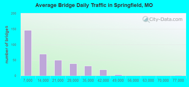
- 4,917,431Total average daily traffic
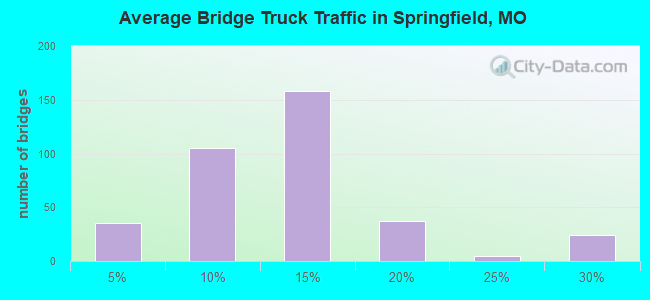
- 538,025Total average daily truck traffic
- National Bridge Inventory (NBI) Registered Bridges for Springfield
- No street view available for this location
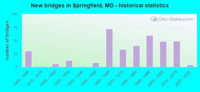
- New bridges - historical statistics
- 301900-1909
- 11910-1919
- 61920-1929
- 121930-1939
- 11940-1949
- 81950-1959
- 721960-1969
- 331970-1979
- 401980-1989
- 601990-1999
- 482000-2009
- 492010-2019
- 42020-2022
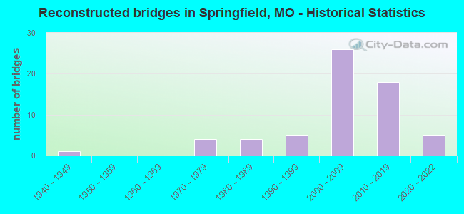
- Reconstructed bridges - Historical Statistics
- 11940-1949
- 01950-1959
- 01960-1969
- 41970-1979
- 41980-1989
- 51990-1999
- 262000-2009
- 182010-2019
- 52020-2022
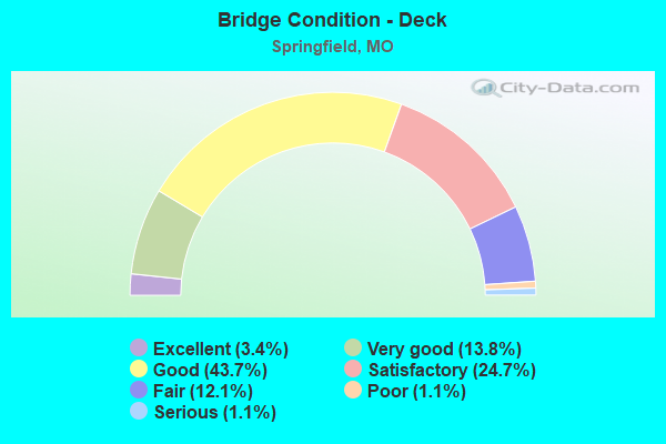
- Bridge Condition - Deck
- 3.4%Excellent
- 13.8%Very good
- 43.7%Good
- 24.7%Satisfactory
- 12.1%Fair
- 1.1%Poor
- 1.1%Serious
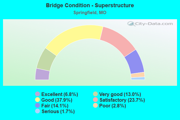
- Bridge Condition - Superstructure
- 6.8%Excellent
- 13.0%Very good
- 37.9%Good
- 23.7%Satisfactory
- 14.1%Fair
- 2.8%Poor
- 1.7%Serious
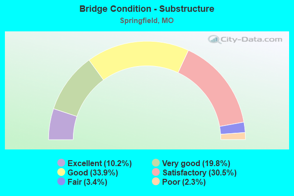
- Bridge Condition - Substructure
- 10.2%Excellent
- 19.8%Very good
- 33.9%Good
- 30.5%Satisfactory
- 3.4%Fair
- 2.3%Poor
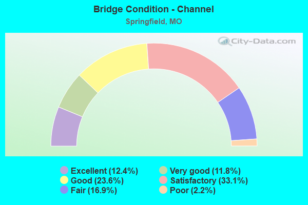
- Bridge Condition - Channel
- 12.4%Excellent
- 11.8%Very good
- 23.6%Good
- 33.1%Satisfactory
- 16.9%Fair
- 2.2%Poor
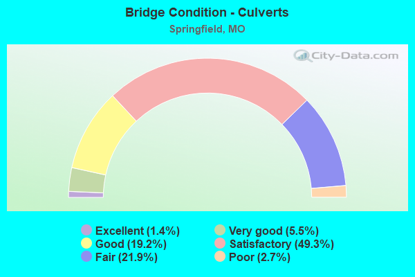
- Bridge Condition - Culverts
- 1.4%Excellent
- 5.5%Very good
- 19.2%Good
- 49.3%Satisfactory
- 21.9%Fair
- 2.7%Poor
Find on map >> Show street view
Structure Number: 296, Location: S 3 T 29 N R 22 W (Lat: 37.250247, Lng: -93.321958), Route carried "on" structure: Interstate 44, Year Built: 1960, Status: Open, Structure Length: 0.77m (2.53ft), Average Daily Traffic: 45,386 (year 2021), Truck Traffic: 28%, Average Future Daily Traffic: 70,348 (year 2041), Design Load: HS 20, Features Intersected: SPRING CR
Minimum Vertical Clearance: 30+ m (98+ ft), Kilometerpoint: 124.065, Lanes on structure: 6, Base Highway Network: Yes, Owner: State Highway Agency, Approaching Roadway Width: 8.5m (27.9ft), Skew: 21 degrees, Material/Design: Concrete continuous, Design/Construction: Culvert, Number Of Spans In Main Unit: 2, Length of Maximum Span: 3.7m (12.1ft)
Condition: Channel: Satisfactory, Culverts: Satisfactory, Operating Rating: 72.0 metric tons, Method Used To Determine Operating Rating: Field evaluation and documented engineering judgment, Inventory Rating: 43.2 metric tons, Method Used To Determine Inventory Rating: Field evaluation and documented engineering judgment, Structural Evaluation: Equal to present minimum criteria, Waterway Adequacy: Equal to present desirable criteria, Approach Roadway Alignment: Equal to present desirable criteria, Designated Inspection Frequency: Every 24 months, Inspection Date: January 2021
Find on map >> Show street view
Structure Number: 2969, Location: S 1 T 29 N R 23 W (Lat: 37.272444, Lng: -93.390458), Route carried "on" structure: US 160, Year Built: 1978, Year Reconstructed: 2020, Status: Posted for load, Structure Length: 6.58m (21.59ft), Average Daily Traffic: 14,510 (year 2021), Truck Traffic: 7%, Average Future Daily Traffic: 23,216 (year 2041), Design Load: HS 20, Features Intersected: ABANDONED RR
Minimum Vertical Clearance: 30+ m (98+ ft), Kilometerpoint: 138.108, Lanes on structure: 2, Base Highway Network: Yes, Owner: State Highway Agency, Approaching Roadway Width: 13.4m (44.0ft), Skew: 24 degrees, Material/Design: Prestressed concrete continuous, Design/Construction: Stringer/Multi-beam, Number Of Spans In Main Unit: 3, Length of Maximum Span: 22.1m (72.5ft), Curb or Sidewalk Widths: Left: 0.2m (0.7ft), Right: 0.2m (0.7ft), Curb-To-Curb Width: 13.4m (44.0ft), Out-to-Out Width: 14.4m (47.2ft)
Condition: Deck: Good, Superstructure: Satisfactory, Substructure: Good, Operating Rating: 62.1 metric tons, Method Used To Determine Operating Rating: Load Factor (LF), Inventory Rating: 30.6 metric tons, Method Used To Determine Inventory Rating: Load Factor (LF), Structural Evaluation: Equal to present minimum criteria, Deck Geometry: Equal to present minimum criteria, Approach Roadway Alignment: Equal to present desirable criteria, Designated Inspection Frequency: Every 24 months, Inspection Date: November 2020, Deck Structure Type: Concrete Cast-file-Place, Wearing Surface/Protective System: Wearing Surface: Other
Find on map >> Show street view
Structure Number: 297, Location: S 2 T 29 N R 22 W (Lat: 37.250339, Lng: -93.310622), Route carried "on" structure: State highway 13, Year Built: 1960, Year Reconstructed: 2009, Status: Posted for load, Structure Length: 6.19m (20.31ft), Average Daily Traffic: 28,051 (year 2021), Truck Traffic: 10%, Average Future Daily Traffic: 43,479 (year 2041), Design Load: H 20, Features Intersected: IS 44
Minimum Vertical Clearance: 30+ m (98+ ft), Kilometerpoint: 371.843, Lanes on structure: 4, Lanes under structure: 4, Base Highway Network: Yes, Owner: State Highway Agency, Approaching Roadway Width: 14.6m (47.9ft), Skew: 20 degrees, Material/Design: Concrete continuous, Design/Construction: Slab, Number Of Spans In Main Unit: 4, Length of Maximum Span: 17.1m (56.1ft), Curb-To-Curb Width: 20.7m (67.9ft), Out-to-Out Width: 22.2m (72.8ft)
Condition: Deck: Fair, Superstructure: Fair, Substructure: Satisfactory, Operating Rating: 48.6 metric tons, Method Used To Determine Operating Rating: Load Factor (LF), Inventory Rating: 28.8 metric tons, Method Used To Determine Inventory Rating: Load Factor (LF), Structural Evaluation: Somewhat better than minimum adequacy, Deck Geometry: Equal to present minimum criteria, Underclear: Meets minimum limits, Approach Roadway Alignment: Equal to present desirable criteria, Designated Inspection Frequency: Every 24 months, Inspection Date: July 2020, Deck Structure Type: Concrete Cast-file-Place, Wearing Surface/Protective System: Wearing Surface: Low Slump Concrete, Deck Protection: Cathodic Protection
Find on map >> Show street view
Structure Number: 298, Location: S 1 T 29 N R 22 W (Lat: 37.250239, Lng: -93.291592), Route carried "on" structure: Interstate 44, Year Built: 1960, Status: Open, Structure Length: 1.02m (3.35ft), Average Daily Traffic: 48,285 (year 2021), Truck Traffic: 28%, Average Future Daily Traffic: 74,842 (year 2041), Design Load: HS 20, Features Intersected: PEA RIDGE CR
Minimum Vertical Clearance: 30+ m (98+ ft), Kilometerpoint: 126.757, Lanes on structure: 4, Base Highway Network: Yes, Owner: State Highway Agency, Approaching Roadway Width: 39.0m (128.0ft), Skew: 22 degrees, Material/Design: Concrete continuous, Design/Construction: Culvert, Number Of Spans In Main Unit: 3, Length of Maximum Span: 3.0m (9.8ft)
Condition: Channel: Good, Culverts: Satisfactory, Structural Evaluation: Equal to present minimum criteria, Waterway Adequacy: Equal to present desirable criteria, Approach Roadway Alignment: Equal to present desirable criteria, Designated Inspection Frequency: Every 24 months, Inspection Date: January 2021
Find on map >> Show street view
Structure Number: 30513, Location: S 7 T 29 N R 21 W (Lat: 37.225650, Lng: -93.264981), Route carried "on" structure: City street , Year Built: 2004, Status: Open, Structure Length: 1.01m (3.31ft), Average Daily Traffic: 12,130 (year 2020), Truck Traffic: 10%, Average Future Daily Traffic: 18,195 (year 2040), Features Intersected: N BR OF JORDAN CR, Facility Carried by Structure: DIVISION ST
Minimum Vertical Clearance: 30+ m (98+ ft), Kilometerpoint: 0.898, Lanes on structure: 3, Owner: City or Municipal Highway Agency, Approaching Roadway Width: 9.4m (30.8ft), Skew: 5 degrees, Material/Design: Concrete, Design/Construction: Culvert, Number Of Spans In Main Unit: 2, Length of Maximum Span: 4.0m (13.1ft)
Condition: Channel: Satisfactory, Culverts: Good, Operating Rating: 63.0 metric tons, Method Used To Determine Operating Rating: Load Factor (LF), Inventory Rating: 37.8 metric tons, Method Used To Determine Inventory Rating: Load Factor (LF), Structural Evaluation: Better than present minimum criteria, Waterway Adequacy: Equal to present desirable criteria, Approach Roadway Alignment: Equal to present desirable criteria, Designated Inspection Frequency: Every 24 months, Inspection Date: May 2020
Find on map >> Show street view
Structure Number: 30514, Location: S 2 T 29 N R 22 W (Lat: 37.251594, Lng: -93.277553), Route carried "on" structure: City street , Year Built: 2003, Status: Open, Structure Length: 0.73m (2.40ft), Average Daily Traffic: 8,200 (year 2020), Truck Traffic: 10%, Average Future Daily Traffic: 12,300 (year 2040), Features Intersected: DRAIN DTCH, Facility Carried by Structure: NORTON RD
Minimum Vertical Clearance: 30+ m (98+ ft), Kilometerpoint: 3.776, Lanes on structure: 3, Owner: City or Municipal Highway Agency, Approaching Roadway Width: 11.9m (39.0ft), Material/Design: Concrete, Design/Construction: Culvert, Number Of Spans In Main Unit: 2, Length of Maximum Span: 3.7m (12.1ft)
Condition: Channel: Excellent, Culverts: Satisfactory, Operating Rating: 50.4 metric tons, Method Used To Determine Operating Rating: Load Factor (LF), Inventory Rating: 30.6 metric tons, Method Used To Determine Inventory Rating: Load Factor (LF), Structural Evaluation: Equal to present minimum criteria, Waterway Adequacy: Equal to present desirable criteria, Approach Roadway Alignment: Equal to present desirable criteria, Designated Inspection Frequency: Every 24 months, Inspection Date: May 2020
Find on map >> Show street view
Structure Number: 30515, Location: S 13 T 29 N R 22 W (Lat: 37.224058, Lng: -93.275378), Route carried "on" structure: City street , Year Built: 2004, Status: Open, Structure Length: 0.98m (3.22ft), Average Daily Traffic: 18,500 (year 2020), Truck Traffic: 10%, Average Future Daily Traffic: 27,750 (year 2040), Design Load: HS 20, Features Intersected: UPPER JORDAN CR, Facility Carried by Structure: NATIONAL AVE
Minimum Vertical Clearance: 30+ m (98+ ft), Kilometerpoint: 4.184, Lanes on structure: 4, Owner: City or Municipal Highway Agency, Approaching Roadway Width: 14.6m (47.9ft), Skew: 7 degrees, Material/Design: Concrete, Design/Construction: Culvert, Number Of Spans In Main Unit: 2, Length of Maximum Span: 4.6m (15.1ft), Curb or Sidewalk Widths: Left: 1.2m (3.9ft), Right: 1.2m (3.9ft), Curb-To-Curb Width: 23.8m (78.1ft), Out-to-Out Width: 24.4m (80.1ft)
Condition: Channel: Good, Culverts: Satisfactory, Operating Rating: 59.4 metric tons, Method Used To Determine Operating Rating: Load Factor (LF), Inventory Rating: 35.1 metric tons, Method Used To Determine Inventory Rating: Load Factor (LF), Structural Evaluation: Equal to present minimum criteria, Deck Geometry: Superior to present desirable criteria, Waterway Adequacy: Superior to present desirable criteria, Approach Roadway Alignment: Equal to present desirable criteria, Designated Inspection Frequency: Every 24 months, Inspection Date: May 2020, Wearing Surface/Protective System: Wearing Surface: Bituminous, Membrane: Built-up
Find on map >> Show street view
Structure Number: 30516, Location: S 27 T 28 N R 21 W (Lat: 37.099792, Lng: -93.222475), Route carried "on" structure: City street , Year Built: 1995, Status: Open, Structure Length: 4.00m (13.12ft), Average Daily Traffic: 400 (year 2020), Truck Traffic: 5%, Average Future Daily Traffic: 600 (year 2040), Features Intersected: HUNT BR, Facility Carried by Structure: MILLWOOD DR
Minimum Vertical Clearance: 30+ m (98+ ft), Kilometerpoint: 0.705, Lanes on structure: 2, Owner: City or Municipal Highway Agency, Approaching Roadway Width: 10.7m (35.1ft), Material/Design: Prestressed concrete continuous, Design/Construction: Stringer/Multi-beam, Number Of Spans In Main Unit: 2, Length of Maximum Span: 19.7m (64.6ft), Curb or Sidewalk Widths: Left: 1.2m (3.9ft), Right: 1.2m (3.9ft), Curb-To-Curb Width: 10.7m (35.1ft), Out-to-Out Width: 14.3m (46.9ft)
Condition: Deck: Good, Superstructure: Excellent, Substructure: Very good, Channel: Good, Operating Rating: 43.2 metric tons, Method Used To Determine Operating Rating: Load Factor (LF), Inventory Rating: 26.1 metric tons, Method Used To Determine Inventory Rating: Allowable Stress (AS), Structural Evaluation: Equal to present minimum criteria, Deck Geometry: Better than present minimum criteria, Waterway Adequacy: Equal to present desirable criteria, Approach Roadway Alignment: Equal to present desirable criteria, Designated Inspection Frequency: Every 24 months, Inspection Date: May 2020, Deck Structure Type: Concrete Cast-file-Place, Wearing Surface/Protective System: Wearing Surface: Monolithic Concrete
Find on map >> Show street view
Structure Number: 30745, Location: S 14 T 29 N R 21 W (Lat: 37.208800, Lng: -93.195333), Route carried "on" structure: County highway 132, Year Built: 2002, Status: Open, Structure Length: 2.07m (6.79ft), Average Daily Traffic: 1,900 (year 2020), Truck Traffic: 10%, Average Future Daily Traffic: 3,895 (year 2040), Design Load: HS 20, Features Intersected: PEARSON CR
Minimum Vertical Clearance: 30+ m (98+ ft), Kilometerpoint: 37.981, Lanes on structure: 2, Owner: County Highway Agency, Approaching Roadway Width: 10.4m (34.1ft), Skew: 5 degrees, Material/Design: Concrete continuous, Design/Construction: Culvert, Number Of Spans In Main Unit: 3, Length of Maximum Span: 6.1m (20.0ft), Curb-To-Curb Width: 10.4m (34.1ft), Out-to-Out Width: 11.3m (37.1ft)
Condition: Channel: Good, Culverts: Good, Operating Rating: 73.8 metric tons, Method Used To Determine Operating Rating: Load Factor (LF), Inventory Rating: 44.1 metric tons, Method Used To Determine Inventory Rating: Load Factor (LF), Structural Evaluation: Better than present minimum criteria, Deck Geometry: Equal to present minimum criteria, Waterway Adequacy: Superior to present desirable criteria, Approach Roadway Alignment: Equal to present desirable criteria, Designated Inspection Frequency: Every 24 months, Inspection Date: March 2020, Deck Structure Type: Concrete Cast-file-Place, Wearing Surface/Protective System: Wearing Surface: Monolithic Concrete
Find on map >> Show street view
Structure Number: 30746, Location: S 4 T 29 N R 21 W (Lat: 37.261083, Lng: -93.234692), Route carried "on" structure: County highway 102, Year Built: 2002, Status: Open, Structure Length: 0.85m (2.79ft), Average Daily Traffic: 957 (year 2020), Truck Traffic: 10%, Average Future Daily Traffic: 1,436 (year 2040), Design Load: HS 20, Features Intersected: BR OF DRY SAC RVR
Minimum Vertical Clearance: 30+ m (98+ ft), Kilometerpoint: 33.313, Lanes on structure: 3, Owner: County Highway Agency, Approaching Roadway Width: 13.1m (43.0ft), Skew: 3 degrees, Material/Design: Concrete continuous, Design/Construction: Culvert, Number Of Spans In Main Unit: 2, Length of Maximum Span: 3.7m (12.1ft), Curb-To-Curb Width: 13.1m (43.0ft), Out-to-Out Width: 13.1m (43.0ft)
Condition: Channel: Fair, Culverts: Good, Operating Rating: 58.5 metric tons, Method Used To Determine Operating Rating: Load Factor (LF), Inventory Rating: 35.1 metric tons, Method Used To Determine Inventory Rating: Load Factor (LF), Structural Evaluation: Better than present minimum criteria, Deck Geometry: Meets minimum limits, Waterway Adequacy: Superior to present desirable criteria, Approach Roadway Alignment: Equal to present desirable criteria, Designated Inspection Frequency: Every 24 months, Inspection Date: April 2020, Deck Structure Type: Concrete Cast-file-Place, Wearing Surface/Protective System: Wearing Surface: Bituminous
Find on map >> Show street view
Structure Number: 30934, Location: S 18 T 28 N R 22 W (Lat: 37.134311, Lng: -93.380839), Route carried "on" structure: County highway 174, Year Built: 1997, Status: Open, Structure Length: 3.54m (11.61ft), Average Daily Traffic: 50 (year 2020), Truck Traffic: 10%, Average Future Daily Traffic: 103 (year 2040), Design Load: HS 20+Mod, Features Intersected: WILSON CR
Minimum Vertical Clearance: 30+ m (98+ ft), Kilometerpoint: 20.600, Lanes on structure: 2, Owner: County Highway Agency, Approaching Roadway Width: 6.1m (20.0ft), Material/Design: Prestressed concrete continuous, Design/Construction: Tee Beam, Number Of Spans In Main Unit: 3, Length of Maximum Span: 11.6m (38.1ft), Curb-To-Curb Width: 7.0m (23.0ft), Out-to-Out Width: 8.1m (26.6ft)
Condition: Deck: Good, Superstructure: Good, Substructure: Very good, Channel: Very good, Operating Rating: 79.2 metric tons, Method Used To Determine Operating Rating: Load Factor (LF), Inventory Rating: 51.3 metric tons, Method Used To Determine Inventory Rating: Load Factor (LF), Structural Evaluation: Better than present minimum criteria, Deck Geometry: Somewhat better than minimum adequacy, Waterway Adequacy: Superior to present desirable criteria, Approach Roadway Alignment: Equal to present minimum criteria, Designated Inspection Frequency: Every 24 months, Inspection Date: April 2020, Deck Structure Type: Concrete Cast-file-Place, Wearing Surface/Protective System: Wearing Surface: Monolithic Concrete
Find on map >> Show street view
Structure Number: 31434, Location: S 7 T 28 N R 22 W (Lat: 37.139114, Lng: -93.377233), Route carried "on" structure: State highway M, Year Built: 2006, Status: Open, Structure Length: 14.83m (48.65ft), Average Daily Traffic: 7,846 (year 2021), Truck Traffic: 3%, Average Future Daily Traffic: 12,554 (year 2041), Design Load: HS 20, Features Intersected: WILSON CR
Minimum Vertical Clearance: 30+ m (98+ ft), Kilometerpoint: 4.902, Lanes on structure: 2, Owner: State Highway Agency, Approaching Roadway Width: 11.0m (36.1ft), Material/Design: Prestressed concrete continuous, Design/Construction: Tee Beam, Number Of Spans In Main Unit: 5, Length of Maximum Span: 29.6m (97.1ft), Curb-To-Curb Width: 11.0m (36.1ft), Out-to-Out Width: 11.8m (38.7ft)
Condition: Deck: Very good, Superstructure: Very good, Substructure: Excellent, Channel: Very good, Operating Rating: 57.6 metric tons, Method Used To Determine Operating Rating: Load Factor (LF), Inventory Rating: 34.2 metric tons, Method Used To Determine Inventory Rating: Load Factor (LF), Structural Evaluation: Equal to present desirable criteria, Deck Geometry: Meets minimum limits, Waterway Adequacy: Superior to present desirable criteria, Approach Roadway Alignment: Equal to present desirable criteria, Designated Inspection Frequency: Every 24 months, Inspection Date: July 2020, Deck Structure Type: Concrete Cast-file-Place, Wearing Surface/Protective System: Wearing Surface: Monolithic Concrete, Deck Protection: Epoxy Coated Reinforcing
Find on map >> Show street view
Structure Number: 3148, Location: S 22 T 28 N R 22 W (Lat: 37.112975, Lng: -93.323864), Route carried "on" structure: County highway 141, Year Built: 2000, Status: Open, Structure Length: 12.01m (39.40ft), Average Daily Traffic: 3,136 (year 2020), Truck Traffic: 10%, Average Future Daily Traffic: 4,704 (year 2040), Design Load: HS 20, Features Intersected: WARD BR OF JAMES R
Minimum Vertical Clearance: 30+ m (98+ ft), Kilometerpoint: 0.000, Lanes on structure: 4, Owner: County Highway Agency, Approaching Roadway Width: 11.0m (36.1ft), Skew: 5 degrees, Material/Design: Prestressed concrete continuous, Design/Construction: Stringer/Multi-beam, Number Of Spans In Main Unit: 5, Length of Maximum Span: 23.8m (78.1ft), Curb or Sidewalk Widths: Left: 1.6m (5.2ft), Right: 1.6m (5.2ft), Curb-To-Curb Width: 15.2m (49.9ft), Out-to-Out Width: 19.4m (63.6ft)
Condition: Deck: Very good, Superstructure: Very good, Substructure: Very good, Channel: Very good, Operating Rating: 82.8 metric tons, Method Used To Determine Operating Rating: Load Factor (LF), Inventory Rating: 45.9 metric tons, Method Used To Determine Inventory Rating: Load Factor (LF), Structural Evaluation: Equal to present desirable criteria, Deck Geometry: High priority of corrective action, Waterway Adequacy: Superior to present desirable criteria, Approach Roadway Alignment: Equal to present desirable criteria, Designated Inspection Frequency: Every 24 months, Inspection Date: March 2020, Deck Structure Type: Concrete Precast Panels
Find on map >> Show street view
Structure Number: 31481, Location: S 27 T 28 N R 22 W (Lat: 37.105894, Lng: -93.329928), Route carried "on" structure: County highway 190, Year Built: 1999, Status: Open, Structure Length: 4.26m (13.98ft), Average Daily Traffic: 750 (year 2020), Truck Traffic: 10%, Average Future Daily Traffic: 1,125 (year 2040), Design Load: HS 20+Mod, Features Intersected: WARD BR
Minimum Vertical Clearance: 30+ m (98+ ft), Kilometerpoint: 0.000, Lanes on structure: 2, Owner: County Highway Agency, Approaching Roadway Width: 7.3m (24.0ft), Skew: 2 degrees, Material/Design: Prestressed concrete continuous, Design/Construction: Stringer/Multi-beam, Number Of Spans In Main Unit: 3, Length of Maximum Span: 19.3m (63.3ft), Curb or Sidewalk Widths: Left: 1.2m (3.9ft), Right: 0.0m, Curb-To-Curb Width: 10.0m (32.8ft), Out-to-Out Width: 12.0m (39.4ft)
Condition: Deck: Good, Superstructure: Good, Substructure: Good, Channel: Good, Operating Rating: 81.0 metric tons, Method Used To Determine Operating Rating: Load Factor (LF), Inventory Rating: 48.6 metric tons, Method Used To Determine Inventory Rating: Allowable Stress (AS), Structural Evaluation: Better than present minimum criteria, Deck Geometry: Equal to present minimum criteria, Waterway Adequacy: Equal to present desirable criteria, Approach Roadway Alignment: Equal to present desirable criteria, Designated Inspection Frequency: Every 24 months, Inspection Date: April 2020, Deck Structure Type: Concrete Precast Panels
Find on map >> Show street view
Structure Number: 315, Location: S 3 T 29 N R 21 W (Lat: 37.250250, Lng: -93.224342), Route carried "on" structure: US 65, Year Built: 2007, Status: Open, Structure Length: 4.05m (13.29ft), Average Daily Traffic: 25,610 (year 2021), Truck Traffic: 15%, Average Future Daily Traffic: 39,696 (year 2041), Design Load: HS 20, Features Intersected: IS 44
Minimum Vertical Clearance: 30+ m (98+ ft), Kilometerpoint: 87.025, Lanes on structure: 3, Lanes under structure: 6, Base Highway Network: Yes, Owner: State Highway Agency, Approaching Roadway Width: 15.8m (51.8ft), Material/Design: Steel continuous, Design/Construction: Stringer/Multi-beam, Number Of Spans In Main Unit: 2, Length of Maximum Span: 20.3m (66.6ft), Curb-To-Curb Width: 15.8m (51.8ft), Out-to-Out Width: 16.7m (54.8ft)
Condition: Deck: Very good, Superstructure: Very good, Substructure: Good, Operating Rating: 87.3 metric tons, Method Used To Determine Operating Rating: Load Factor (LF), Inventory Rating: 52.2 metric tons, Method Used To Determine Inventory Rating: Load Factor (LF), Structural Evaluation: Better than present minimum criteria, Deck Geometry: Somewhat better than minimum adequacy, Underclear: High priority of corrective action, Approach Roadway Alignment: Equal to present desirable criteria, Designated Inspection Frequency: Every 24 months, Inspection Date: August 2020, Deck Structure Type: Concrete Cast-file-Place, Wearing Surface/Protective System: Wearing Surface: Monolithic Concrete, Deck Protection: Epoxy Coated Reinforcing
Find on map >> Show street view
Structure Number: 31505, Location: S 3 T 29 N R 21 W (Lat: 37.250142, Lng: -93.224894), Route carried "on" structure: Ramp State highway , Year Built: 2006, Status: Open, Structure Length: 42.18m (138.39ft), Average Daily Traffic: 10,067 (year 2021), Truck Traffic: 10%, Average Future Daily Traffic: 15,604 (year 2041), Design Load: HS 25 or greater, Features Intersected: IS 44, RP IS44E TO US6, Facility Carried by Structure: RP US65N TO IS44W
Minimum Vertical Clearance: 30+ m (98+ ft), Kilometerpoint: 0.262, Lanes on structure: 2, Lanes under structure: 14, Base Highway Network: Yes, Owner: State Highway Agency, Approaching Roadway Width: 11.6m (38.1ft), Skew: 4 degrees, Material/Design: Steel continuous, Design/Construction: Stringer/Multi-beam, Number Of Spans In Main Unit: 3, Number Of Approach Spans: 4, Length of Maximum Span: 68.3m (224.1ft), Curb-To-Curb Width: 11.6m (38.1ft), Out-to-Out Width: 12.4m (40.7ft)
Condition: Deck: Satisfactory, Superstructure: Very good, Substructure: Satisfactory, Operating Rating: 79.2 metric tons, Method Used To Determine Operating Rating: Load Factor (LF), Inventory Rating: 47.7 metric tons, Method Used To Determine Inventory Rating: Load Factor (LF), Structural Evaluation: Equal to present minimum criteria, Deck Geometry: Superior to present desirable criteria, Approach Roadway Alignment: Equal to present desirable criteria, Designated Inspection Frequency: Every 24 months, Inspection Date: June 2021, Deck Structure Type: Concrete Cast-file-Place, Wearing Surface/Protective System: Wearing Surface: Monolithic Concrete, Deck Protection: Epoxy Coated Reinforcing
Find on map >> Show street view
Structure Number: 31875, Location: S 4 T 29 N R 21 W (Lat: 37.263650, Lng: -93.224839), Route carried "on" structure: US 65, Year Built: 2007, Status: Open, Structure Length: 6.70m (21.98ft), Average Daily Traffic: 8,148 (year 2021), Truck Traffic: 18%, Average Future Daily Traffic: 12,629 (year 2041), Design Load: HS 20, Features Intersected: S DRY SAC CR
Minimum Vertical Clearance: 30+ m (98+ ft), Kilometerpoint: 415.271, Lanes on structure: 2, Base Highway Network: Yes, Owner: State Highway Agency, Approaching Roadway Width: 11.6m (38.1ft), Material/Design: Prestressed concrete continuous, Design/Construction: Stringer/Multi-beam, Number Of Spans In Main Unit: 3, Length of Maximum Span: 24.4m (80.1ft), Curb-To-Curb Width: 11.6m (38.1ft), Out-to-Out Width: 12.4m (40.7ft)
Condition: Deck: Very good, Superstructure: Very good, Substructure: Very good, Channel: Good, Operating Rating: 58.5 metric tons, Method Used To Determine Operating Rating: Load Factor (LF), Inventory Rating: 35.1 metric tons, Method Used To Determine Inventory Rating: Load Factor (LF), Structural Evaluation: Equal to present desirable criteria, Deck Geometry: Better than present minimum criteria, Waterway Adequacy: Superior to present desirable criteria, Approach Roadway Alignment: Equal to present desirable criteria, Designated Inspection Frequency: Every 24 months, Inspection Date: July 2020, Deck Structure Type: Concrete Cast-file-Place, Wearing Surface/Protective System: Wearing Surface: Monolithic Concrete, Deck Protection: Epoxy Coated Reinforcing
Find on map >> Show street view
Structure Number: 31876, Location: S 30 T 30 N R 20 W (Lat: 37.288639, Lng: -93.186211), Route carried "on" structure: US 65, Year Built: 2007, Status: Open, Structure Length: 4.35m (14.27ft), Average Daily Traffic: 8,148 (year 2021), Truck Traffic: 18%, Average Future Daily Traffic: 12,629 (year 2041), Design Load: HS 20, Features Intersected: CRD 197
Minimum Vertical Clearance: 30+ m (98+ ft), Kilometerpoint: 410.804, Lanes on structure: 2, Lanes under structure: 2, Base Highway Network: Yes, Owner: State Highway Agency, Approaching Roadway Width: 11.6m (38.1ft), Skew: 2 degrees, Material/Design: Prestressed concrete continuous, Design/Construction: Stringer/Multi-beam, Number Of Spans In Main Unit: 3, Length of Maximum Span: 15.2m (49.9ft), Curb-To-Curb Width: 11.6m (38.1ft), Out-to-Out Width: 12.4m (40.7ft)
Condition: Deck: Very good, Superstructure: Very good, Substructure: Excellent, Operating Rating: 65.7 metric tons, Method Used To Determine Operating Rating: Load Factor (LF), Inventory Rating: 39.6 metric tons, Method Used To Determine Inventory Rating: Load Factor (LF), Structural Evaluation: Equal to present desirable criteria, Deck Geometry: Better than present minimum criteria, Underclear: Equal to present minimum criteria, Approach Roadway Alignment: Equal to present desirable criteria, Designated Inspection Frequency: Every 24 months, Inspection Date: July 2020, Deck Structure Type: Concrete Cast-file-Place, Wearing Surface/Protective System: Wearing Surface: Monolithic Concrete, Deck Protection: Epoxy Coated Reinforcing
Find on map >> Show street view
Structure Number: 32417, Location: S 18 T 29 N R 21 W (Lat: 37.224281, Lng: -93.273667), Route carried "on" structure: City street , Year Built: 2007, Status: Open, Structure Length: 0.94m (3.08ft), Average Daily Traffic: 800 (year 2020), Truck Traffic: 10%, Average Future Daily Traffic: 1,200 (year 2040), Features Intersected: N BR OF JORDAN CR, Facility Carried by Structure: PROSPECT AVE
Minimum Vertical Clearance: 30+ m (98+ ft), Kilometerpoint: 0.000, Lanes on structure: 2, Owner: City or Municipal Highway Agency, Approaching Roadway Width: 9.1m (29.9ft), Material/Design: Concrete, Design/Construction: Slab, Number Of Spans In Main Unit: 2, Length of Maximum Span: 4.6m (15.1ft), Curb or Sidewalk Widths: Left: 3.0m (9.8ft), Right: 6.1m (20.0ft), Curb-To-Curb Width: 9.1m (29.9ft), Out-to-Out Width: 18.7m (61.4ft)
Condition: Deck: Good, Superstructure: Good, Substructure: Good, Channel: Excellent, Operating Rating: 43.2 metric tons, Method Used To Determine Operating Rating: Load Factor (LF), Inventory Rating: 26.1 metric tons, Method Used To Determine Inventory Rating: Load Factor (LF), Structural Evaluation: Equal to present minimum criteria, Deck Geometry: Equal to present minimum criteria, Waterway Adequacy: Better than present minimum criteria, Approach Roadway Alignment: Equal to present desirable criteria, Designated Inspection Frequency: Every 24 months, Inspection Date: May 2020, Deck Structure Type: Concrete Cast-file-Place
Find on map >> Show street view
Structure Number: 32418, Location: S 18 T 29 N R 21 W (Lat: 37.224575, Lng: -93.272025), Route carried "on" structure: City street , Year Built: 2007, Status: Open, Structure Length: 0.96m (3.15ft), Average Daily Traffic: 800 (year 2020), Truck Traffic: 10%, Average Future Daily Traffic: 1,200 (year 2040), Features Intersected: N BR JORDAN CR, Facility Carried by Structure: ROGERS AVE
Minimum Vertical Clearance: 30+ m (98+ ft), Kilometerpoint: 0.000, Lanes on structure: 2, Owner: City or Municipal Highway Agency, Approaching Roadway Width: 9.1m (29.9ft), Material/Design: Concrete, Design/Construction: Slab, Number Of Spans In Main Unit: 2, Length of Maximum Span: 4.6m (15.1ft), Curb or Sidewalk Widths: Left: 4.3m (14.1ft), Right: 4.0m (13.1ft), Curb-To-Curb Width: 9.1m (29.9ft), Out-to-Out Width: 18.3m (60.0ft)
Condition: Deck: Good, Superstructure: Good, Substructure: Good, Channel: Excellent, Operating Rating: 43.2 metric tons, Method Used To Determine Operating Rating: Load Factor (LF), Inventory Rating: 26.1 metric tons, Method Used To Determine Inventory Rating: Load Factor (LF), Structural Evaluation: Equal to present minimum criteria, Deck Geometry: Equal to present minimum criteria, Waterway Adequacy: Better than present minimum criteria, Approach Roadway Alignment: Equal to present desirable criteria, Designated Inspection Frequency: Every 24 months, Inspection Date: May 2020, Deck Structure Type: Concrete Cast-file-Place, Wearing Surface/Protective System: Wearing Surface: Bituminous
Find on map >> Show street view
Structure Number: 32542, Location: S 13 T 29 N R 23 W (Lat: 37.224236, Lng: -93.403439), Route carried "on" structure: City street , Year Built: 2009, Status: Open, Structure Length: 7.59m (24.90ft), Average Daily Traffic: 11,001 (year 2020), Truck Traffic: 10%, Average Future Daily Traffic: 22,552 (year 2040), Design Load: HS 20, Features Intersected: BNSF N TRACK, BNSF S TRA, Facility Carried by Structure: AIRPORT DRIVE
Minimum Vertical Clearance: 30+ m (98+ ft), Kilometerpoint: 0.000, Lanes on structure: 2, Owner: City or Municipal Highway Agency, Approaching Roadway Width: 13.4m (44.0ft), Material/Design: Steel continuous, Design/Construction: Stringer/Multi-beam, Number Of Spans In Main Unit: 3, Length of Maximum Span: 30.2m (99.1ft), Curb-To-Curb Width: 13.4m (44.0ft), Out-to-Out Width: 14.0m (45.9ft)
Condition: Deck: Good, Superstructure: Very good, Substructure: Satisfactory, Operating Rating: 71.1 metric tons, Method Used To Determine Operating Rating: Load Factor (LF), Inventory Rating: 42.3 metric tons, Method Used To Determine Inventory Rating: Load Factor (LF), Structural Evaluation: Equal to present minimum criteria, Deck Geometry: Equal to present minimum criteria, Underclear: Superior to present desirable criteria, Approach Roadway Alignment: Equal to present desirable criteria, Designated Inspection Frequency: Every 24 months, Inspection Date: May 2020, Deck Structure Type: Concrete Cast-file-Place, Wearing Surface/Protective System: Wearing Surface: Monolithic Concrete, Deck Protection: Epoxy Coated Reinforcing
Find on map >> Show street view
Structure Number: 32545, Location: S 6 T 29 N R 21 W (Lat: 37.250369, Lng: -93.262747), Route carried "on" structure: State highway H, Year Built: 2008, Status: Open, Structure Length: 5.44m (17.85ft), Average Daily Traffic: 10,912 (year 2021), Truck Traffic: 5%, Average Future Daily Traffic: 17,459 (year 2041), Features Intersected: IS 44
Minimum Vertical Clearance: 30+ m (98+ ft), Kilometerpoint: 42.496, Lanes on structure: 6, Lanes under structure: 4, Base Highway Network: Yes, Owner: State Highway Agency, Approaching Roadway Width: 26.2m (86.0ft), Skew: 2 degrees, Material/Design: Prestressed concrete continuous, Design/Construction: Stringer/Multi-beam, Number Of Spans In Main Unit: 2, Length of Maximum Span: 26.8m (87.9ft), Curb-To-Curb Width: 26.2m (86.0ft), Out-to-Out Width: 27.0m (88.6ft)
Condition: Deck: Good, Superstructure: Good, Substructure: Good, Operating Rating: 56.7 metric tons, Method Used To Determine Operating Rating: Load Factor (LF), Inventory Rating: 34.2 metric tons, Method Used To Determine Inventory Rating: Load Factor (LF), Structural Evaluation: Better than present minimum criteria, Deck Geometry: Equal to present minimum criteria, Underclear: Equal to present minimum criteria, Approach Roadway Alignment: Equal to present desirable criteria, Designated Inspection Frequency: Every 24 months, Inspection Date: July 2020, Deck Structure Type: Concrete Cast-file-Place, Wearing Surface/Protective System: Wearing Surface: Monolithic Concrete, Deck Protection: Epoxy Coated Reinforcing
Find on map >> Show street view
Structure Number: 32668, Location: S 16 T 28 N R 21 W (Lat: 37.130014, Lng: -93.234611), Route carried "on" structure: Ramp State highway , Year Built: 2009, Status: Open, Structure Length: 11.03m (36.19ft), Average Daily Traffic: 10,660 (year 2021), Truck Traffic: 5%, Average Future Daily Traffic: 16,523 (year 2041), Features Intersected: GALLOWAY CR, BNSF RR, OZ, Facility Carried by Structure: RP US65N TO US60W
Minimum Vertical Clearance: 30+ m (98+ ft), Kilometerpoint: 1.212, Lanes on structure: 1, Base Highway Network: Yes, Owner: State Highway Agency, Approaching Roadway Width: 7.9m (25.9ft), Material/Design: Prestressed concrete continuous, Design/Construction: Stringer/Multi-beam, Number Of Spans In Main Unit: 5, Length of Maximum Span: 26.6m (87.3ft), Curb-To-Curb Width: 7.9m (25.9ft), Out-to-Out Width: 8.7m (28.5ft)
Condition: Deck: Good, Superstructure: Excellent, Substructure: Very good, Channel: Good, Operating Rating: 53.1 metric tons, Method Used To Determine Operating Rating: Load Factor (LF), Inventory Rating: 30.6 metric tons, Method Used To Determine Inventory Rating: Load Factor (LF), Structural Evaluation: Better than present minimum criteria, Deck Geometry: Equal to present desirable criteria, Underclear: Better than present minimum criteria, Waterway Adequacy: Superior to present desirable criteria, Approach Roadway Alignment: Equal to present desirable criteria, Designated Inspection Frequency: Every 24 months, Inspection Date: July 2020, Deck Structure Type: Concrete Cast-file-Place, Wearing Surface/Protective System: Wearing Surface: Monolithic Concrete, Deck Protection: Epoxy Coated Reinforcing
Find on map >> Show street view
Structure Number: 3268, Location: S 30 T 42 N R 15 W (Lat: 38.370814, Lng: -92.617569), Route carried "on" structure: State highway 52, Year Built: 1981, Status: Open, Structure Length: 7.16m (23.49ft), Average Daily Traffic: 5,746 (year 2021), Truck Traffic: 9%, Average Future Daily Traffic: 12,067 (year 2041), Design Load: H 20, Features Intersected: S FK MOREAU RVR
Minimum Vertical Clearance: 30+ m (98+ ft), Kilometerpoint: 226.126, Lanes on structure: 2, Base Highway Network: Yes, Owner: State Highway Agency, Approaching Roadway Width: 13.4m (44.0ft), Skew: 13 degrees, Material/Design: Prestressed concrete continuous, Design/Construction: Stringer/Multi-beam, Number Of Spans In Main Unit: 4, Length of Maximum Span: 18.2m (59.7ft), Curb or Sidewalk Widths: Left: 0.2m (0.7ft), Right: 0.2m (0.7ft), Curb-To-Curb Width: 13.4m (44.0ft), Out-to-Out Width: 14.2m (46.6ft)
Condition: Deck: Satisfactory, Superstructure: Good, Substructure: Satisfactory, Channel: Satisfactory, Operating Rating: 67.5 metric tons, Method Used To Determine Operating Rating: Load Factor (LF), Inventory Rating: 27.9 metric tons, Method Used To Determine Inventory Rating: Load Factor (LF), Structural Evaluation: Equal to present minimum criteria, Deck Geometry: Equal to present minimum criteria, Waterway Adequacy: Equal to present desirable criteria, Approach Roadway Alignment: Equal to present desirable criteria, Designated Inspection Frequency: Every 24 months, Inspection Date: November 2020, Deck Structure Type: Concrete Cast-file-Place, Wearing Surface/Protective System: Wearing Surface: Monolithic Concrete, Deck Protection: Epoxy Coated Reinforcing
Find on map >> Show street view
Structure Number: 3268, Location: S 16 T 28 N R 21 W (Lat: 37.129547, Lng: -93.234436), Route carried "on" structure: US 60, Year Built: 2010, Status: Open, Structure Length: 10.79m (35.40ft), Average Daily Traffic: 35,362 (year 2021), Truck Traffic: 4%, Average Future Daily Traffic: 54,811 (year 2041), Features Intersected: GALLOWAY CR, BNSF RR, OZ
Minimum Vertical Clearance: 30+ m (98+ ft), Kilometerpoint: 407.166, Lanes on structure: 3, Base Highway Network: Yes, Owner: State Highway Agency, Approaching Roadway Width: 14.6m (47.9ft), Material/Design: Prestressed concrete continuous, Design/Construction: Stringer/Multi-beam, Number Of Spans In Main Unit: 5, Length of Maximum Span: 26.5m (86.9ft), Curb-To-Curb Width: 14.6m (47.9ft), Out-to-Out Width: 15.4m (50.5ft)
Condition: Deck: Very good, Superstructure: Very good, Substructure: Very good, Channel: Good, Operating Rating: 79.2 metric tons, Method Used To Determine Operating Rating: Load Factor (LF), Inventory Rating: 47.7 metric tons, Method Used To Determine Inventory Rating: Load Factor (LF), Structural Evaluation: Equal to present desirable criteria, Deck Geometry: Meets minimum limits, Underclear: Better than present minimum criteria, Waterway Adequacy: Superior to present desirable criteria, Approach Roadway Alignment: Equal to present desirable criteria, Designated Inspection Frequency: Every 24 months, Inspection Date: July 2020, Deck Structure Type: Concrete Cast-file-Place, Wearing Surface/Protective System: Wearing Surface: Monolithic Concrete, Deck Protection: Epoxy Coated Reinforcing
Find on map >> Show street view
Structure Number: 32695, Location: S 16 T 28 N R 21 W (Lat: 37.129408, Lng: -93.234978), Route carried "on" structure: US 60, Year Built: 2009, Status: Open, Structure Length: 10.79m (35.40ft), Average Daily Traffic: 34,443 (year 2021), Truck Traffic: 7%, Average Future Daily Traffic: 53,387 (year 2041), Features Intersected: GALLOWAY CR, BNSF RR, OZ
Minimum Vertical Clearance: 30+ m (98+ ft), Kilometerpoint: 140.871, Lanes on structure: 2, Base Highway Network: Yes, Owner: State Highway Agency, Approaching Roadway Width: 11.6m (38.1ft), Material/Design: Prestressed concrete continuous, Design/Construction: Stringer/Multi-beam, Number Of Spans In Main Unit: 5, Length of Maximum Span: 26.5m (86.9ft), Curb-To-Curb Width: 11.6m (38.1ft), Out-to-Out Width: 12.4m (40.7ft)
Condition: Deck: Satisfactory, Superstructure: Very good, Substructure: Very good, Channel: Good, Operating Rating: 78.3 metric tons, Method Used To Determine Operating Rating: Load Factor (LF), Inventory Rating: 46.8 metric tons, Method Used To Determine Inventory Rating: Load Factor (LF), Structural Evaluation: Equal to present desirable criteria, Deck Geometry: Equal to present minimum criteria, Underclear: Superior to present desirable criteria, Waterway Adequacy: Superior to present desirable criteria, Approach Roadway Alignment: Equal to present desirable criteria, Designated Inspection Frequency: Every 24 months, Inspection Date: July 2020, Deck Structure Type: Concrete Cast-file-Place, Wearing Surface/Protective System: Wearing Surface: Monolithic Concrete, Deck Protection: Epoxy Coated Reinforcing
Find on map >> Show street view
Structure Number: 32706, Location: S 6 T 28 N R 21 W (Lat: 37.129319, Lng: -93.236197), Route carried "on" structure: Ramp State highway , Year Built: 2010, Status: Open, Structure Length: 12.50m (41.01ft), Average Daily Traffic: 11,120 (year 2021), Truck Traffic: 5%, Average Future Daily Traffic: 17,236 (year 2041), Features Intersected: GALLOWAY CR, BNSF RR, OZ, Facility Carried by Structure: RP US60E TO US65N
Minimum Vertical Clearance: 30+ m (98+ ft), Kilometerpoint: 0.274, Lanes on structure: 2, Base Highway Network: Yes, Owner: State Highway Agency, Approaching Roadway Width: 8.4m (27.6ft), Material/Design: Steel continuous, Design/Construction: Stringer/Multi-beam, Number Of Spans In Main Unit: 3, Number Of Approach Spans: 1, Length of Maximum Span: 38.7m (127.0ft), Curb-To-Curb Width: 8.4m (27.6ft), Out-to-Out Width: 9.3m (30.5ft)
Condition: Deck: Satisfactory, Superstructure: Very good, Substructure: Excellent, Channel: Good, Operating Rating: 56.7 metric tons, Method Used To Determine Operating Rating: Load Factor (LF), Inventory Rating: 34.2 metric tons, Method Used To Determine Inventory Rating: Load Factor (LF), Structural Evaluation: Equal to present desirable criteria, Deck Geometry: High priority of corrective action, Underclear: Better than present minimum criteria, Waterway Adequacy: Superior to present desirable criteria, Approach Roadway Alignment: Equal to present desirable criteria, Length Of Structure Improvement: 1.33m (4.36ft), Designated Inspection Frequency: Every 24 months, Inspection Date: July 2020, Bridge Improvement Cost: $1,085,000, Roadway Improvement Cost: $108,000, Total Project Cost: $1,627,000 ( Estimate for 2022), Deck Structure Type: Concrete Cast-file-Place, Wearing Surface/Protective System: Wearing Surface: Monolithic Concrete, Deck Protection: Epoxy Coated Reinforcing
Find on map >> Show street view
Structure Number: 32717, Location: S 16 T 28 N R 21 W (Lat: 37.128228, Lng: -93.230286), Route carried "on" structure: Ramp State highway , Year Built: 2010, Status: Open, Structure Length: 61.54m (201.90ft), Average Daily Traffic: 11,120 (year 2021), Truck Traffic: 5%, Average Future Daily Traffic: 17,236 (year 2041), Design Load: HS 20, Features Intersected: RP US60W TO US65N, Facility Carried by Structure: RP US60E TO US65N
Minimum Vertical Clearance: 30+ m (98+ ft), Kilometerpoint: 0.475, Lanes on structure: 1, Lanes under structure: 14, Base Highway Network: Yes, Owner: State Highway Agency, Approaching Roadway Width: 8.8m (28.9ft), Skew: 2 degrees, Material/Design: Steel continuous, Design/Construction: Stringer/Multi-beam, Number Of Spans In Main Unit: 4, Number Of Approach Spans: 13, Length of Maximum Span: 49.1m (161.1ft), Curb-To-Curb Width: 8.8m (28.9ft), Out-to-Out Width: 9.7m (31.8ft)
Condition: Deck: Satisfactory, Superstructure: Very good, Substructure: Very good, Operating Rating: 56.7 metric tons, Method Used To Determine Operating Rating: Load Factor (LF), Inventory Rating: 34.2 metric tons, Method Used To Determine Inventory Rating: Load Factor (LF), Structural Evaluation: Equal to present desirable criteria, Deck Geometry: Superior to present desirable criteria, Underclear: High priority of corrective action, Approach Roadway Alignment: Equal to present desirable criteria, Designated Inspection Frequency: Every 24 months, Inspection Date: October 2020, Deck Structure Type: Concrete Cast-file-Place, Wearing Surface/Protective System: Wearing Surface: Other, Deck Protection: Epoxy Coated Reinforcing
Find on map >> Show street view
Structure Number: 32796, Location: S 16 T 28 N R 21 W (Lat: 37.128136, Lng: -93.229814), Route carried "on" structure: Ramp State highway , Year Built: 2009, Status: Open, Structure Length: 50.20m (164.70ft), Average Daily Traffic: 10,660 (year 2021), Truck Traffic: 5%, Average Future Daily Traffic: 16,523 (year 2041), Features Intersected: RP US60W TO US65S, Facility Carried by Structure: RP US65N TO US60W
Minimum Vertical Clearance: 5.07m (16.63ft), Kilometerpoint: 0.515, Lanes on structure: 1, Lanes under structure: 13, Base Highway Network: Yes, Owner: State Highway Agency, Approaching Roadway Width: 9.4m (30.8ft), Skew: 2 degrees, Material/Design: Steel continuous, Design/Construction: Stringer/Multi-beam, Number Of Spans In Main Unit: 5, Number Of Approach Spans: 9, Length of Maximum Span: 48.2m (158.1ft), Curb-To-Curb Width: 9.4m (30.8ft), Out-to-Out Width: 10.3m (33.8ft)
Condition: Deck: Satisfactory, Superstructure: Satisfactory, Substructure: Good, Operating Rating: 58.5 metric tons, Method Used To Determine Operating Rating: Load Factor (LF), Inventory Rating: 35.1 metric tons, Method Used To Determine Inventory Rating: Load Factor (LF), Structural Evaluation: Equal to present minimum criteria, Deck Geometry: Equal to present minimum criteria, Underclear: High priority of corrective action, Approach Roadway Alignment: Equal to present desirable criteria, Designated Inspection Frequency: Every 24 months, Inspection Date: October 2020, Deck Structure Type: Concrete Cast-file-Place, Wearing Surface/Protective System: Wearing Surface: Monolithic Concrete, Deck Protection: Epoxy Coated Reinforcing
Find on map >> Show street view
Structure Number: 328, Location: S 21 T 29 N R 21 W (Lat: 37.197572, Lng: -93.226289), Route carried "on" structure: US 65, Year Built: 2011, Status: Open, Structure Length: 6.28m (20.60ft), Average Daily Traffic: 78,622 (year 2021), Truck Traffic: 9%, Average Future Daily Traffic: 121,864 (year 2041), Features Intersected: BNSF RR
Minimum Vertical Clearance: 30+ m (98+ ft), Kilometerpoint: 422.606, Lanes on structure: 6, Base Highway Network: Yes, Owner: State Highway Agency, Approaching Roadway Width: 16.2m (53.1ft), Material/Design: Steel continuous, Design/Construction: Stringer/Multi-beam, Number Of Spans In Main Unit: 3, Length of Maximum Span: 28.2m (92.5ft), Curb-To-Curb Width: 32.3m (106.0ft), Out-to-Out Width: 33.7m (110.6ft)
Condition: Deck: Good, Superstructure: Good, Substructure: Good, Operating Rating: 72.0 metric tons, Method Used To Determine Operating Rating: Load Factor (LF), Inventory Rating: 43.2 metric tons, Method Used To Determine Inventory Rating: Load Factor (LF), Structural Evaluation: Better than present minimum criteria, Deck Geometry: Superior to present desirable criteria, Underclear: Superior to present desirable criteria, Approach Roadway Alignment: Equal to present desirable criteria, Designated Inspection Frequency: Every 24 months, Inspection Date: August 2020, Deck Structure Type: Concrete Cast-file-Place, Wearing Surface/Protective System: Wearing Surface: Monolithic Concrete, Deck Protection: Epoxy Coated Reinforcing
Find on map >> Show street view
Structure Number: 32802, Location: S 16 T 28 N R 21 W (Lat: 37.127900, Lng: -93.230622), Route carried "on" structure: US 65, Year Built: 2010, Status: Open, Structure Length: 6.80m (22.31ft), Average Daily Traffic: 32,081 (year 2021), Truck Traffic: 10%, Average Future Daily Traffic: 49,726 (year 2041), Features Intersected: US 60
Minimum Vertical Clearance: 30+ m (98+ ft), Kilometerpoint: 73.280, Lanes on structure: 3, Lanes under structure: 4, Base Highway Network: Yes, Owner: State Highway Agency, Approaching Roadway Width: 17.5m (57.4ft), Skew: 1 degrees, Material/Design: Prestressed concrete continuous, Design/Construction: Stringer/Multi-beam, Number Of Spans In Main Unit: 4, Length of Maximum Span: 22.7m (74.5ft), Curb-To-Curb Width: 17.5m (57.4ft), Out-to-Out Width: 18.3m (60.0ft)
Condition: Deck: Good, Superstructure: Good, Substructure: Very good, Operating Rating: 78.3 metric tons, Method Used To Determine Operating Rating: Load Factor (LF), Inventory Rating: 46.8 metric tons, Method Used To Determine Inventory Rating: Load Factor (LF), Structural Evaluation: Better than present minimum criteria, Deck Geometry: Better than present minimum criteria, Underclear: Meets minimum limits, Approach Roadway Alignment: Equal to present desirable criteria, Designated Inspection Frequency: Every 24 months, Inspection Date: July 2020, Deck Structure Type: Concrete Cast-file-Place, Wearing Surface/Protective System: Wearing Surface: Monolithic Concrete, Deck Protection: Epoxy Coated Reinforcing
Find on map >> Show street view
Structure Number: 32809, Location: S 15 T 28 N R 21 W (Lat: 37.124150, Lng: -93.225544), Route carried "on" structure: US 60, Year Built: 2009, Status: Open, Structure Length: 12.71m (41.70ft), Average Daily Traffic: 13,761 (year 2021), Truck Traffic: 14%, Average Future Daily Traffic: 21,330 (year 2041), Features Intersected: JAMES RVR
Minimum Vertical Clearance: 30+ m (98+ ft), Kilometerpoint: 406.235, Lanes on structure: 3, Base Highway Network: Yes, Owner: State Highway Agency, Approaching Roadway Width: 14.6m (47.9ft), Skew: 2 degrees, Material/Design: Steel continuous, Design/Construction: Stringer/Multi-beam, Number Of Spans In Main Unit: 3, Length of Maximum Span: 53.0m (173.9ft), Curb-To-Curb Width: 14.6m (47.9ft), Out-to-Out Width: 15.4m (50.5ft)
Condition: Deck: Satisfactory, Superstructure: Very good, Substructure: Very good, Channel: Very good, Operating Rating: 69.3 metric tons, Method Used To Determine Operating Rating: Load Factor (LF), Inventory Rating: 41.4 metric tons, Method Used To Determine Inventory Rating: Load Factor (LF), Structural Evaluation: Equal to present desirable criteria, Deck Geometry: Meets minimum limits, Waterway Adequacy: Superior to present desirable criteria, Approach Roadway Alignment: Equal to present desirable criteria, Designated Inspection Frequency: Every 24 months, Inspection Date: August 2020, Deck Structure Type: Concrete Cast-file-Place, Wearing Surface/Protective System: Wearing Surface: Monolithic Concrete, Deck Protection: Epoxy Coated Reinforcing
Find on map >> Show street view
Structure Number: 33289, Location: S 3 T 28 N R 22 W (Lat: 37.167492, Lng: -93.316244), Route carried "on" structure: State highway 13, Year Built: 2010, Status: Open, Structure Length: 1.98m (6.50ft), Average Daily Traffic: 31,767 (year 2021), Truck Traffic: 4%, Average Future Daily Traffic: 49,239 (year 2041), Design Load: HS 20, Features Intersected: SOUTH CR
Minimum Vertical Clearance: 30+ m (98+ ft), Kilometerpoint: 381.208, Lanes on structure: 5, Base Highway Network: Yes, Owner: State Highway Agency, Approaching Roadway Width: 18.3m (60.0ft), Skew: 1 degrees, Material/Design: Concrete continuous, Design/Construction: Culvert, Number Of Spans In Main Unit: 5, Length of Maximum Span: 3.7m (12.1ft), Out-to-Out Width: 18.3m (60.0ft)
Condition: Channel: Satisfactory, Culverts: Satisfactory, Operating Rating: 89.1 metric tons, Method Used To Determine Operating Rating: Load Factor (LF), Inventory Rating: 54.0 metric tons, Method Used To Determine Inventory Rating: Load Factor (LF), Structural Evaluation: Equal to present minimum criteria, Waterway Adequacy: Superior to present desirable criteria, Approach Roadway Alignment: Equal to present desirable criteria, Designated Inspection Frequency: Every 24 months, Inspection Date: January 2021
Find on map >> Show street view
Structure Number: 33295, Location: S 7 T 28 N R 21 W (Lat: 37.143778, Lng: -93.278083), Route carried "on" structure: City street , Year Built: 2009, Status: Open, Structure Length: 1.83m (6.00ft), Average Daily Traffic: 12,870 (year 2020), Truck Traffic: 10%, Average Future Daily Traffic: 19,305 (year 2040), Features Intersected: COXHEALTH ACCESS R, Facility Carried by Structure: NATIONAL AVE S
Minimum Vertical Clearance: 30+ m (98+ ft), Kilometerpoint: 0.000, Lanes on structure: 7, Lanes under structure: 2, Owner: City or Municipal Highway Agency, Approaching Roadway Width: 38.2m (125.3ft), Skew: 6 degrees, Material/Design: Prestressed concrete, Design/Construction: Box Beam or Girders - Multiple, Number Of Spans In Main Unit: 1, Length of Maximum Span: 17.1m (56.1ft), Curb-To-Curb Width: 38.2m (125.3ft), Out-to-Out Width: 39.0m (128.0ft)
Condition: Deck: Good, Superstructure: Fair, Substructure: Good, Operating Rating: 63.0 metric tons, Method Used To Determine Operating Rating: Load and Resistance Factor (LRFR), Inventory Rating: 37.8 metric tons, Method Used To Determine Inventory Rating: Load and Resistance Factor (LRFR), Structural Evaluation: Somewhat better than minimum adequacy, Deck Geometry: Superior to present desirable criteria, Underclear: Equal to present minimum criteria, Approach Roadway Alignment: Equal to present desirable criteria, Designated Inspection Frequency: Every 24 months, Inspection Date: May 2020, Deck Structure Type: Concrete Cast-file-Place, Wearing Surface/Protective System: Wearing Surface: Monolithic Concrete, Deck Protection: Epoxy Coated Reinforcing
Find on map >> Show street view
Structure Number: 33437, Location: S 12 T 29 N R 21 W (Lat: 37.222428, Lng: -93.170750), Route carried "on" structure: State highway YY, Year Built: 2011, Status: Open, Structure Length: 2.38m (7.81ft), Average Daily Traffic: 7,961 (year 2021), Truck Traffic: 4%, Average Future Daily Traffic: 12,738 (year 2041), Design Load: HS 20+Mod, Features Intersected: PEARSON CR
Minimum Vertical Clearance: 30+ m (98+ ft), Kilometerpoint: 4.913, Lanes on structure: 2, Owner: State Highway Agency, Approaching Roadway Width: 8.5m (27.9ft), Skew: 4 degrees, Material/Design: Concrete continuous, Design/Construction: Slab, Number Of Spans In Main Unit: 3, Length of Maximum Span: 9.1m (29.9ft), Curb-To-Curb Width: 8.5m (27.9ft), Out-to-Out Width: 9.1m (29.9ft)
Condition: Deck: Very good, Superstructure: Very good, Substructure: Good, Channel: Fair, Operating Rating: 98.1 metric tons, Method Used To Determine Operating Rating: Load Factor (LF), Inventory Rating: 59.4 metric tons, Method Used To Determine Inventory Rating: Load Factor (LF), Structural Evaluation: Better than present minimum criteria, Deck Geometry: High priority of replacement, Waterway Adequacy: Superior to present desirable criteria, Approach Roadway Alignment: Equal to present desirable criteria, Length Of Structure Improvement: 0.32m (1.05ft), Designated Inspection Frequency: Every 24 months, Inspection Date: August 2020, Bridge Improvement Cost: $274,000, Roadway Improvement Cost: $27,000, Total Project Cost: $411,000 ( Estimate for 2022), Deck Structure Type: Concrete Cast-file-Place, Wearing Surface/Protective System: Wearing Surface: Bituminous, Deck Protection: Epoxy Coated Reinforcing
Find on map >> Show street view
Structure Number: 3387, Location: S 6 T 28 N R 22 W (Lat: 37.160239, Lng: -93.387861), Route carried "on" structure: County highway 115, Year Built: 1992, Status: Open, Structure Length: 8.14m (26.71ft), Average Daily Traffic: 694 (year 2020), Truck Traffic: 4%, Average Future Daily Traffic: 1,110 (year 2040), Design Load: HS 20, Features Intersected: US 60
Minimum Vertical Clearance: 30+ m (98+ ft), Kilometerpoint: 6.095, Lanes on structure: 2, Lanes under structure: 4, Owner: State Highway Agency, Approaching Roadway Width: 10.4m (34.1ft), Material/Design: Steel continuous, Design/Construction: Stringer/Multi-beam, Number Of Spans In Main Unit: 2, Length of Maximum Span: 35.3m (115.8ft), Curb or Sidewalk Widths: Left: 0.2m (0.7ft), Right: 0.2m (0.7ft), Curb-To-Curb Width: 10.0m (32.8ft), Out-to-Out Width: 10.8m (35.4ft)
Condition: Deck: Good, Superstructure: Good, Substructure: Good, Operating Rating: 72.9 metric tons, Method Used To Determine Operating Rating: Load Factor (LF), Inventory Rating: 44.1 metric tons, Method Used To Determine Inventory Rating: Load Factor (LF), Structural Evaluation: Better than present minimum criteria, Deck Geometry: Equal to present minimum criteria, Underclear: Better than present minimum criteria, Approach Roadway Alignment: Equal to present desirable criteria, Designated Inspection Frequency: Every 24 months, Inspection Date: August 2020, Deck Structure Type: Concrete Cast-file-Place, Wearing Surface/Protective System: Wearing Surface: Monolithic Concrete, Deck Protection: Epoxy Coated Reinforcing
Find on map >> Show street view
Structure Number: 3388, Location: S 10 T 28 N R 22 W (Lat: 37.142603, Lng: -93.332303), Route carried "on" structure: City street , Year Built: 1992, Status: Open, Structure Length: 7.77m (25.49ft), Average Daily Traffic: 8,677 (year 2021), Truck Traffic: 1%, Average Future Daily Traffic: 13,883 (year 2041), Design Load: HS 20, Features Intersected: US 60, Facility Carried by Structure: SCENIC AVE S
Minimum Vertical Clearance: 30+ m (98+ ft), Kilometerpoint: 7.612, Lanes on structure: 2, Lanes under structure: 4, Owner: State Highway Agency, Approaching Roadway Width: 9.1m (29.9ft), Material/Design: Steel continuous, Design/Construction: Stringer/Multi-beam, Number Of Spans In Main Unit: 2, Length of Maximum Span: 33.5m (109.9ft), Curb or Sidewalk Widths: Left: 0.2m (0.7ft), Right: 0.2m (0.7ft), Curb-To-Curb Width: 8.8m (28.9ft), Out-to-Out Width: 9.7m (31.8ft)
Condition: Deck: Satisfactory, Superstructure: Good, Substructure: Satisfactory, Operating Rating: 66.6 metric tons, Method Used To Determine Operating Rating: Load Factor (LF), Inventory Rating: 39.6 metric tons, Method Used To Determine Inventory Rating: Load Factor (LF), Structural Evaluation: Equal to present minimum criteria, Deck Geometry: Meets minimum limits, Underclear: Better than present minimum criteria, Approach Roadway Alignment: Equal to present desirable criteria, Designated Inspection Frequency: Every 24 months, Inspection Date: August 2020, Deck Structure Type: Concrete Cast-file-Place, Wearing Surface/Protective System: Wearing Surface: Epoxy Overlay, Deck Protection: Epoxy Coated Reinforcing
Find on map >> Show street view
Structure Number: 339, Location: S 6 T 28 N R 22 W (Lat: 37.159597, Lng: -93.377192), Route carried "on" structure: US 60, Year Built: 1995, Status: Open, Structure Length: 10.55m (34.61ft), Average Daily Traffic: 14,228 (year 2021), Truck Traffic: 13%, Average Future Daily Traffic: 22,053 (year 2041), Design Load: HS 20+Mod, Features Intersected: WILSON CR
Minimum Vertical Clearance: 30+ m (98+ ft), Kilometerpoint: 126.734, Lanes on structure: 2, Base Highway Network: Yes, Owner: State Highway Agency, Approaching Roadway Width: 12.2m (40.0ft), Skew: 1 degrees, Material/Design: Prestressed concrete continuous, Design/Construction: Stringer/Multi-beam, Number Of Spans In Main Unit: 5, Length of Maximum Span: 21.2m (69.6ft), Curb or Sidewalk Widths: Left: 0.2m (0.7ft), Right: 0.2m (0.7ft), Curb-To-Curb Width: 11.8m (38.7ft), Out-to-Out Width: 12.6m (41.3ft)
Condition: Deck: Very good, Superstructure: Satisfactory, Substructure: Very good, Channel: Very good, Operating Rating: 80.1 metric tons, Method Used To Determine Operating Rating: Load Factor (LF), Inventory Rating: 37.8 metric tons, Method Used To Determine Inventory Rating: Load Factor (LF), Structural Evaluation: Equal to present minimum criteria, Deck Geometry: Equal to present minimum criteria, Waterway Adequacy: Equal to present desirable criteria, Approach Roadway Alignment: Equal to present desirable criteria, Designated Inspection Frequency: Every 24 months, Inspection Date: August 2020, Deck Structure Type: Concrete Cast-file-Place, Wearing Surface/Protective System: Wearing Surface: Monolithic Concrete, Deck Protection: Epoxy Coated Reinforcing
Find on map >> Show street view
Structure Number: 3392, Location: S 8 T 28 N R 22 W (Lat: 37.151614, Lng: -93.363025), Route carried "on" structure: US 160, Year Built: 1991, Status: Open, Structure Length: 9.11m (29.89ft), Average Daily Traffic: 16,672 (year 2021), Truck Traffic: 10%, Average Future Daily Traffic: 25,842 (year 2041), Design Load: HS 20+Mod, Features Intersected: US 60
Minimum Vertical Clearance: 30+ m (98+ ft), Kilometerpoint: 153.844, Lanes on structure: 6, Lanes under structure: 4, Base Highway Network: Yes, Owner: State Highway Agency, Approaching Roadway Width: 24.4m (80.1ft), Skew: 2 degrees, Material/Design: Steel continuous, Design/Construction: Stringer/Multi-beam, Number Of Spans In Main Unit: 2, Length of Maximum Span: 37.3m (122.4ft), Curb or Sidewalk Widths: Left: 0.2m (0.7ft), Right: 0.2m (0.7ft), Curb-To-Curb Width: 24.0m (78.7ft), Out-to-Out Width: 24.8m (81.4ft)
Condition: Deck: Satisfactory, Superstructure: Good, Substructure: Satisfactory, Operating Rating: 67.5 metric tons, Method Used To Determine Operating Rating: Load Factor (LF), Inventory Rating: 38.7 metric tons, Method Used To Determine Inventory Rating: Load Factor (LF), Structural Evaluation: Equal to present minimum criteria, Deck Geometry: Meets minimum limits, Underclear: Better than present minimum criteria, Approach Roadway Alignment: Equal to present desirable criteria, Designated Inspection Frequency: Every 24 months, Inspection Date: August 2020, Deck Structure Type: Concrete Cast-file-Place, Wearing Surface/Protective System: Wearing Surface: Monolithic Concrete, Deck Protection: Epoxy Coated Reinforcing
Find on map >> Show street view
Structure Number: 3393, Location: S 8 T 28 N R 22 W (Lat: 37.154161, Lng: -93.366542), Route carried "on" structure: US 60, Year Built: 1994, Status: Open, Structure Length: 9.78m (32.09ft), Average Daily Traffic: 14,469 (year 2021), Truck Traffic: 16%, Average Future Daily Traffic: 22,427 (year 2041), Design Load: HS 20, Features Intersected: SOUTH CR
Minimum Vertical Clearance: 30+ m (98+ ft), Kilometerpoint: 420.204, Lanes on structure: 3, Base Highway Network: Yes, Owner: State Highway Agency, Approaching Roadway Width: 15.2m (49.9ft), Skew: 10 degrees, Material/Design: Prestressed concrete, Design/Construction: Stringer/Multi-beam, Number Of Spans In Main Unit: 5, Length of Maximum Span: 19.7m (64.6ft), Curb or Sidewalk Widths: Left: 0.2m (0.7ft), Right: 0.2m (0.7ft), Curb-To-Curb Width: 14.9m (48.9ft), Out-to-Out Width: 15.7m (51.5ft)
Condition: Deck: Very good, Superstructure: Satisfactory, Substructure: Very good, Channel: Good, Operating Rating: 71.1 metric tons, Method Used To Determine Operating Rating: Load Factor (LF), Inventory Rating: 36.9 metric tons, Method Used To Determine Inventory Rating: Load Factor (LF), Structural Evaluation: Equal to present minimum criteria, Deck Geometry: Meets minimum limits, Waterway Adequacy: Equal to present desirable criteria, Approach Roadway Alignment: Equal to present desirable criteria, Designated Inspection Frequency: Every 24 months, Inspection Date: August 2020, Deck Structure Type: Concrete Cast-file-Place, Wearing Surface/Protective System: Wearing Surface: Monolithic Concrete, Deck Protection: Epoxy Coated Reinforcing
Find on map >> Show street view
Structure Number: 3394, Location: S 8 T 28 N R 22 W (Lat: 37.153847, Lng: -93.366614), Route carried "on" structure: US 60, Year Built: 1994, Status: Open, Structure Length: 9.78m (32.09ft), Average Daily Traffic: 14,228 (year 2021), Truck Traffic: 13%, Average Future Daily Traffic: 22,053 (year 2041), Design Load: HS 20, Features Intersected: SOUTH CR
Minimum Vertical Clearance: 30+ m (98+ ft), Kilometerpoint: 127.885, Lanes on structure: 3, Base Highway Network: Yes, Owner: State Highway Agency, Approaching Roadway Width: 15.2m (49.9ft), Skew: 10 degrees, Material/Design: Prestressed concrete, Design/Construction: Stringer/Multi-beam, Number Of Spans In Main Unit: 5, Length of Maximum Span: 19.7m (64.6ft), Curb or Sidewalk Widths: Left: 0.2m (0.7ft), Right: 0.2m (0.7ft), Curb-To-Curb Width: 14.9m (48.9ft), Out-to-Out Width: 15.7m (51.5ft)
Condition: Deck: Very good, Superstructure: Satisfactory, Substructure: Very good, Channel: Good, Operating Rating: 71.1 metric tons, Method Used To Determine Operating Rating: Load Factor (LF), Inventory Rating: 36.9 metric tons, Method Used To Determine Inventory Rating: Load Factor (LF), Structural Evaluation: Equal to present minimum criteria, Deck Geometry: Meets minimum limits, Waterway Adequacy: Equal to present desirable criteria, Approach Roadway Alignment: Equal to present desirable criteria, Designated Inspection Frequency: Every 24 months, Inspection Date: August 2020, Deck Structure Type: Concrete Cast-file-Place, Wearing Surface/Protective System: Wearing Surface: Monolithic Concrete, Deck Protection: Epoxy Coated Reinforcing