Bridge Statistics for Springfield, Missouri (MO)
Condition, Traffic, Stress, Structural Evaluation, Project Costs
- National Bridge Inventory (NBI) Statistics
- 364Number of bridges
- 4,213ft / 1,284mTotal length
- $39,542,000Total costs
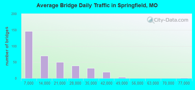
- 4,917,431Total average daily traffic
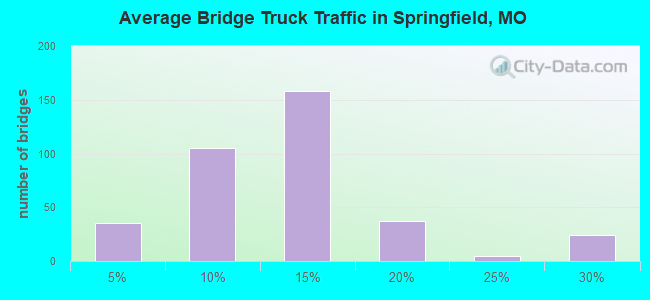
- 538,025Total average daily truck traffic
- National Bridge Inventory (NBI) Registered Bridges for Springfield
- No street view available for this location
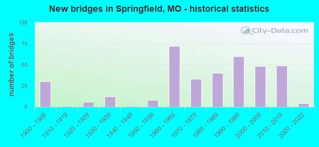
- New bridges - historical statistics
- 301900-1909
- 11910-1919
- 61920-1929
- 121930-1939
- 11940-1949
- 81950-1959
- 721960-1969
- 331970-1979
- 401980-1989
- 601990-1999
- 482000-2009
- 492010-2019
- 42020-2022
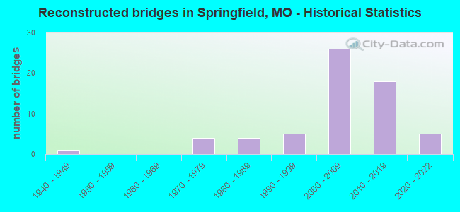
- Reconstructed bridges - Historical Statistics
- 11940-1949
- 01950-1959
- 01960-1969
- 41970-1979
- 41980-1989
- 51990-1999
- 262000-2009
- 182010-2019
- 52020-2022
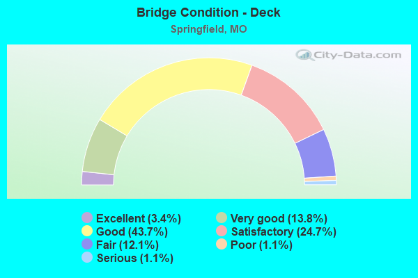
- Bridge Condition - Deck
- 3.4%Excellent
- 13.8%Very good
- 43.7%Good
- 24.7%Satisfactory
- 12.1%Fair
- 1.1%Poor
- 1.1%Serious
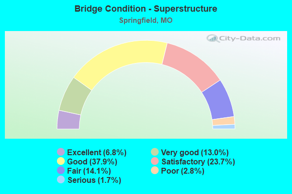
- Bridge Condition - Superstructure
- 6.8%Excellent
- 13.0%Very good
- 37.9%Good
- 23.7%Satisfactory
- 14.1%Fair
- 2.8%Poor
- 1.7%Serious
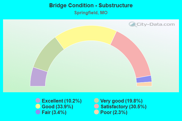
- Bridge Condition - Substructure
- 10.2%Excellent
- 19.8%Very good
- 33.9%Good
- 30.5%Satisfactory
- 3.4%Fair
- 2.3%Poor
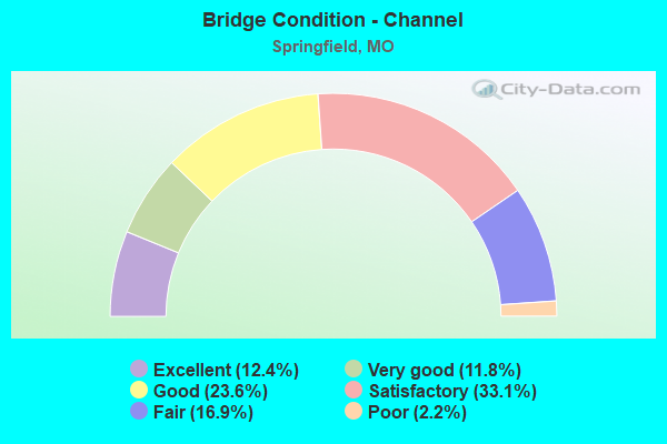
- Bridge Condition - Channel
- 12.4%Excellent
- 11.8%Very good
- 23.6%Good
- 33.1%Satisfactory
- 16.9%Fair
- 2.2%Poor
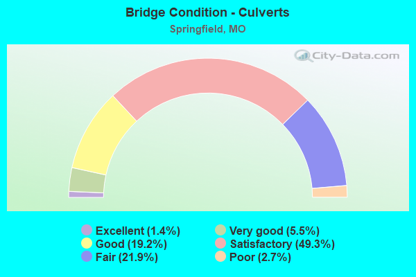
- Bridge Condition - Culverts
- 1.4%Excellent
- 5.5%Very good
- 19.2%Good
- 49.3%Satisfactory
- 21.9%Fair
- 2.7%Poor
Find on map >> Show street view
Structure Number: 949, Location: S 21 T 29 N R 21 W (Lat: 37.197917, Lng: -93.225431), Route carried "on" structure: ServiceState highway 65, Year Built: 1970, Status: Posted for load, Structure Length: 3.72m (12.20ft), Average Daily Traffic: 6,892 (year 2021), Truck Traffic: 10%, Average Future Daily Traffic: 11,027 (year 2041), Features Intersected: BNSF RR
Minimum Vertical Clearance: 30+ m (98+ ft), Kilometerpoint: 1.345, Lanes on structure: 2, Owner: State Highway Agency, Approaching Roadway Width: 8.2m (26.9ft), Material/Design: Steel continuous, Design/Construction: Stringer/Multi-beam, Number Of Spans In Main Unit: 3, Length of Maximum Span: 14.0m (45.9ft), Curb or Sidewalk Widths: Left: 1.5m (4.9ft), Right: 0.6m (2.0ft), Curb-To-Curb Width: 7.3m (24.0ft), Out-to-Out Width: 9.4m (30.8ft)
Condition: Deck: Fair, Superstructure: Satisfactory, Substructure: Poor, Operating Rating: 16.2 metric tons, Method Used To Determine Operating Rating: Allowable Stress (AS), Inventory Rating: 9.9 metric tons, Method Used To Determine Inventory Rating: Allowable Stress (AS), Structural Evaluation: High priority of replacement, Deck Geometry: High priority of replacement, Underclear: Equal to present minimum criteria, Approach Roadway Alignment: Equal to present minimum criteria, Bridge Posting: Required (Relationship of Operating Rating to Maximum Legal Load: 20.0 - 29.9% below), Length Of Structure Improvement: 0.46m (1.51ft), Designated Inspection Frequency: Every 12 months, Inspection Date: August 2021, Bridge Improvement Cost: $580,000, Roadway Improvement Cost: $58,000, Total Project Cost: $870,000 ( Estimate for 2022), Deck Structure Type: Concrete Cast-file-Place, Wearing Surface/Protective System: Wearing Surface: Bituminous
Find on map >> Show street view
Structure Number: 988, Location: S 25 T 28 N R 22 W (Lat: 37.098031, Lng: -93.297525), Route carried "on" structure: US 160, Year Built: 1984, Status: Open, Structure Length: 6.98m (22.90ft), Average Daily Traffic: 15,229 (year 2021), Truck Traffic: 6%, Average Future Daily Traffic: 23,605 (year 2041), Design Load: HS 20, Features Intersected: JAMES RVR OVRFL
Minimum Vertical Clearance: 30+ m (98+ ft), Kilometerpoint: 355.788, Lanes on structure: 2, Base Highway Network: Yes, Owner: State Highway Agency, Approaching Roadway Width: 12.2m (40.0ft), Skew: 10 degrees, Material/Design: Prestressed concrete, Design/Construction: Stringer/Multi-beam, Number Of Spans In Main Unit: 4, Length of Maximum Span: 19.2m (63.0ft), Curb or Sidewalk Widths: Left: 0.2m (0.7ft), Right: 0.2m (0.7ft), Curb-To-Curb Width: 11.8m (38.7ft), Out-to-Out Width: 12.6m (41.3ft)
Condition: Deck: Good, Superstructure: Good, Substructure: Satisfactory, Channel: Good, Operating Rating: 54.9 metric tons, Method Used To Determine Operating Rating: Load Factor (LF), Inventory Rating: 26.1 metric tons, Method Used To Determine Inventory Rating: Load Factor (LF), Structural Evaluation: Equal to present minimum criteria, Deck Geometry: Equal to present minimum criteria, Waterway Adequacy: Equal to present desirable criteria, Approach Roadway Alignment: Equal to present desirable criteria, Designated Inspection Frequency: Every 24 months, Inspection Date: August 2020, Deck Structure Type: Concrete Cast-file-Place, Wearing Surface/Protective System: Wearing Surface: Monolithic Concrete, Deck Protection: Epoxy Coated Reinforcing
Find on map >> Show street view
Structure Number: 11823, Location: S 1 T 28 N R 23 W (Lat: 37.161594, Lng: -93.398936), Route carried "under" structure: US 60, Year Built: 1999, Structure Length: 0. m, Average Daily Traffic: 11,993 (year 2021), Truck Traffic: 7%, Features Intersected: US 60
Minimum Vertical Clearance: 5.11m (16.77ft), Kilometerpoint: 423.400, Lanes on structure: 2, Lanes under structure: 2, Material/Design: Steel continuous, Design/Construction: Stringer/Multi-beam, Length of Maximum Span: 36.3m (119.1ft)
Find on map >> Show street view
Structure Number: 11823, Location: S 1 T 28 N R 23 W (Lat: 37.161594, Lng: -93.398936), Route carried "under" structure: State highway 413, Year Built: 1999, Structure Length: 0. m, Average Daily Traffic: 7,785 (year 2021), Truck Traffic: 4%, Features Intersected: MO 413, Facility Carried by Structure: MO 360 W
Minimum Vertical Clearance: 5.11m (16.77ft), Kilometerpoint: 70.534, Lanes on structure: 2, Lanes under structure: 2, Material/Design: Steel continuous, Design/Construction: Stringer/Multi-beam, Length of Maximum Span: 36.3m (119.1ft)
Find on map >> Show street view
Structure Number: 11848, Location: S 1 T 28 N R 23 W (Lat: 37.161408, Lng: -93.399233), Route carried "under" structure: State highway 413, Year Built: 1999, Structure Length: 0. m, Average Daily Traffic: 7,785 (year 2021), Truck Traffic: 4%, Features Intersected: MO 413, Facility Carried by Structure: MO 360 E
Minimum Vertical Clearance: 5.18m (16.99ft), Kilometerpoint: 70.502, Lanes on structure: 2, Lanes under structure: 2, Material/Design: Steel continuous, Design/Construction: Stringer/Multi-beam, Length of Maximum Span: 36.3m (119.1ft)
Find on map >> Show street view
Structure Number: 11848, Location: S 1 T 28 N R 23 W (Lat: 37.161408, Lng: -93.399233), Route carried "under" structure: US 60, Year Built: 1999, Structure Length: 0. m, Average Daily Traffic: 11,993 (year 2021), Truck Traffic: 7%, Features Intersected: US 60
Minimum Vertical Clearance: 5.18m (16.99ft), Kilometerpoint: 423.435, Lanes on structure: 2, Lanes under structure: 2, Material/Design: Steel continuous, Design/Construction: Stringer/Multi-beam, Length of Maximum Span: 36.3m (119.1ft)
Find on map >> Show street view
Structure Number: 11977, Location: S 27 T 29 N R 21 W (Lat: 37.180231, Lng: -93.224717), Route carried "under" structure: Ramp State highway , Year Built: 2001, Structure Length: 0. m, Average Daily Traffic: 8,437 (year 2021), Truck Traffic: 5%, Features Intersected: RP RTDE TO US65S, Facility Carried by Structure: US 65 S
Minimum Vertical Clearance: 5.82m (19.09ft), Kilometerpoint: 0.010, Lanes on structure: 6, Lanes under structure: 1, Material/Design: Steel continuous, Design/Construction: Stringer/Multi-beam, Length of Maximum Span: 50.9m (167.0ft)
Find on map >> Show street view
Structure Number: 11977, Location: S 27 T 29 N R 21 W (Lat: 37.180231, Lng: -93.224717), Route carried "under" structure: Ramp State highway , Year Built: 2001, Structure Length: 0. m, Average Daily Traffic: 8,903 (year 2021), Truck Traffic: 10%, Features Intersected: RP US65S TO RTDE, Facility Carried by Structure: US 65 S
Minimum Vertical Clearance: 5.82m (19.09ft), Kilometerpoint: 0.365, Lanes on structure: 6, Lanes under structure: 1, Material/Design: Steel continuous, Design/Construction: Stringer/Multi-beam, Length of Maximum Span: 50.9m (167.0ft)
Find on map >> Show street view
Structure Number: 11977, Location: S 27 T 29 N R 21 W (Lat: 37.180231, Lng: -93.224717), Route carried "under" structure: Ramp State highway , Year Built: 2001, Structure Length: 0. m, Average Daily Traffic: 6,776 (year 2021), Truck Traffic: 5%, Features Intersected: RP US65N TO RTDW, Facility Carried by Structure: US 65 S
Minimum Vertical Clearance: 5.82m (19.09ft), Kilometerpoint: 0.317, Lanes on structure: 6, Lanes under structure: 1, Material/Design: Steel continuous, Design/Construction: Stringer/Multi-beam, Length of Maximum Span: 50.9m (167.0ft)
Find on map >> Show street view
Structure Number: 11977, Location: S 27 T 29 N R 21 W (Lat: 37.180231, Lng: -93.224717), Route carried "under" structure: State highway D, Year Built: 2001, Structure Length: 0. m, Average Daily Traffic: 23,955 (year 2021), Truck Traffic: 5%, Features Intersected: RT D, Facility Carried by Structure: US 65 S
Minimum Vertical Clearance: 5.31m (17.42ft), Kilometerpoint: 3.347, Lanes on structure: 6, Lanes under structure: 6, Material/Design: Steel continuous, Design/Construction: Stringer/Multi-beam, Length of Maximum Span: 50.9m (167.0ft)
Find on map >> Show street view
Structure Number: 11977, Location: S 27 T 29 N R 21 W (Lat: 37.180231, Lng: -93.224717), Route carried "under" structure: Ramp State highway , Year Built: 2001, Structure Length: 0. m, Average Daily Traffic: 3,247 (year 2021), Truck Traffic: 5%, Features Intersected: RP RTDW TO US65N, Facility Carried by Structure: US 65 S
Minimum Vertical Clearance: 5.82m (19.09ft), Kilometerpoint: 0.010, Lanes on structure: 6, Lanes under structure: 1, Material/Design: Steel continuous, Design/Construction: Stringer/Multi-beam, Length of Maximum Span: 50.9m (167.0ft)
Find on map >> Show street view
Structure Number: 1334, Location: S 9 T 29 N R 21 W (Lat: 37.238856, Lng: -93.224611), Route carried "under" structure: US 65, Year Built: 1968, Structure Length: 0. m, Average Daily Traffic: 28,503 (year 2021), Truck Traffic: 5%, Features Intersected: US 65, Facility Carried by Structure: MO 744 E
Minimum Vertical Clearance: 4.88m (16.01ft), Kilometerpoint: 85.773, Lanes on structure: 2, Lanes under structure: 3, Material/Design: Concrete continuous, Design/Construction: Slab, Length of Maximum Span: 18.3m (60.0ft)
Find on map >> Show street view
Structure Number: 1334, Location: S 9 T 29 N R 21 W (Lat: 37.238856, Lng: -93.224611), Route carried "under" structure: US 65, Year Built: 1968, Structure Length: 0. m, Average Daily Traffic: 26,613 (year 2021), Truck Traffic: 12%, Features Intersected: US 65, Facility Carried by Structure: MO 744 E
Minimum Vertical Clearance: 5.44m (17.85ft), Kilometerpoint: 418.057, Lanes on structure: 2, Lanes under structure: 3, Material/Design: Concrete continuous, Design/Construction: Slab, Length of Maximum Span: 18.3m (60.0ft)
Find on map >> Show street view
Structure Number: 1335, Location: S 9 T 29 N R 21 W (Lat: 37.238925, Lng: -93.224803), Route carried "under" structure: US 65, Year Built: 1968, Structure Length: 0. m, Average Daily Traffic: 26,613 (year 2021), Truck Traffic: 12%, Features Intersected: US 65, Facility Carried by Structure: MO 744 W
Minimum Vertical Clearance: 5.44m (17.85ft), Kilometerpoint: 418.057, Lanes on structure: 3, Lanes under structure: 3, Material/Design: Concrete continuous, Design/Construction: Slab, Length of Maximum Span: 18.3m (60.0ft)
Find on map >> Show street view
Structure Number: 1335, Location: S 9 T 29 N R 21 W (Lat: 37.238925, Lng: -93.224803), Route carried "under" structure: US 65, Year Built: 1968, Structure Length: 0. m, Average Daily Traffic: 28,503 (year 2021), Truck Traffic: 5%, Features Intersected: US 65, Facility Carried by Structure: MO 744 W
Minimum Vertical Clearance: 4.88m (16.01ft), Kilometerpoint: 85.773, Lanes on structure: 3, Lanes under structure: 3, Material/Design: Concrete continuous, Design/Construction: Slab, Length of Maximum Span: 18.3m (60.0ft)
Find on map >> Show street view
Structure Number: 1337, Location: S 16 T 29 N R 21 W (Lat: 37.224239, Lng: -93.225369), Route carried "under" structure: US 65, Year Built: 1968, Structure Length: 0. m, Average Daily Traffic: 29,056 (year 2021), Truck Traffic: 9%, Features Intersected: US 65, Facility Carried by Structure: RT YY E
Minimum Vertical Clearance: 4.75m (15.58ft), Kilometerpoint: 419.679, Lanes on structure: 2, Lanes under structure: 3, Material/Design: Concrete continuous, Design/Construction: Slab, Length of Maximum Span: 18.3m (60.0ft)
Find on map >> Show street view
Structure Number: 1337, Location: S 16 T 29 N R 21 W (Lat: 37.224239, Lng: -93.225369), Route carried "under" structure: US 65, Year Built: 1968, Structure Length: 0. m, Average Daily Traffic: 30,922 (year 2021), Truck Traffic: 5%, Features Intersected: US 65, Facility Carried by Structure: RT YY E
Minimum Vertical Clearance: 4.75m (15.58ft), Kilometerpoint: 84.151, Lanes on structure: 2, Lanes under structure: 3, Material/Design: Concrete continuous, Design/Construction: Slab, Length of Maximum Span: 18.3m (60.0ft)
Find on map >> Show street view
Structure Number: 1338, Location: S 16 T 29 N R 21 W (Lat: 37.224239, Lng: -93.225369), Route carried "under" structure: US 65, Year Built: 1968, Structure Length: 0. m, Average Daily Traffic: 30,922 (year 2021), Truck Traffic: 5%, Features Intersected: US 65, Facility Carried by Structure: RT YY W
Minimum Vertical Clearance: 4.75m (15.58ft), Kilometerpoint: 84.151, Lanes on structure: 3, Lanes under structure: 3, Material/Design: Concrete continuous, Design/Construction: Slab, Length of Maximum Span: 18.3m (60.0ft)
Find on map >> Show street view
Structure Number: 1338, Location: S 16 T 29 N R 21 W (Lat: 37.224239, Lng: -93.225369), Route carried "under" structure: US 65, Year Built: 1968, Structure Length: 0. m, Average Daily Traffic: 29,056 (year 2021), Truck Traffic: 9%, Features Intersected: US 65, Facility Carried by Structure: RT YY W
Minimum Vertical Clearance: 4.75m (15.58ft), Kilometerpoint: 419.679, Lanes on structure: 3, Lanes under structure: 3, Material/Design: Concrete continuous, Design/Construction: Slab, Length of Maximum Span: 18.3m (60.0ft)
Find on map >> Show street view
Structure Number: 1339, Location: S 16 T 29 N R 21 W (Lat: 37.209633, Lng: -93.226081), Route carried "under" structure: Business State highway 65, Year Built: 1968, Structure Length: 0. m, Average Daily Traffic: 14,615 (year 2021), Truck Traffic: 5%, Features Intersected: BU 65
Minimum Vertical Clearance: 4.57m (14.99ft), Kilometerpoint: 0.095, Lanes on structure: 3, Lanes under structure: 2, Material/Design: Concrete continuous, Design/Construction: Slab, Length of Maximum Span: 12.5m (41.0ft)
Find on map >> Show street view
Structure Number: 1339, Location: S 16 T 29 N R 21 W (Lat: 37.209633, Lng: -93.226081), Route carried "under" structure: Business State highway 65, Year Built: 1968, Structure Length: 0. m, Average Daily Traffic: 15,068 (year 2021), Truck Traffic: 5%, Features Intersected: BU 65
Minimum Vertical Clearance: 4.67m (15.32ft), Kilometerpoint: 14.462, Lanes on structure: 3, Lanes under structure: 2, Material/Design: Concrete continuous, Design/Construction: Slab, Length of Maximum Span: 12.5m (41.0ft)
Find on map >> Show street view
Structure Number: 134, Location: S 16 T 29 N R 21 W (Lat: 37.209572, Lng: -93.225886), Route carried "under" structure: Business State highway 65, Year Built: 1968, Structure Length: 0. m, Average Daily Traffic: 15,068 (year 2021), Truck Traffic: 5%, Features Intersected: BU 65
Minimum Vertical Clearance: 4.67m (15.32ft), Kilometerpoint: 14.479, Lanes on structure: 3, Lanes under structure: 2, Material/Design: Concrete continuous, Design/Construction: Slab, Length of Maximum Span: 12.5m (41.0ft)
Find on map >> Show street view
Structure Number: 134, Location: S 16 T 29 N R 21 W (Lat: 37.209572, Lng: -93.225886), Route carried "under" structure: Business State highway 65, Year Built: 1968, Structure Length: 0. m, Average Daily Traffic: 14,615 (year 2021), Truck Traffic: 5%, Features Intersected: BU 65
Minimum Vertical Clearance: 4.57m (14.99ft), Kilometerpoint: 0.077, Lanes on structure: 3, Lanes under structure: 2, Material/Design: Concrete continuous, Design/Construction: Slab, Length of Maximum Span: 12.5m (41.0ft)
Find on map >> Show street view
Structure Number: 1341, Location: S 21 T 29 N R 21 W (Lat: 37.202133, Lng: -93.226097), Route carried "under" structure: US 65, Year Built: 1968, Structure Length: 0. m, Average Daily Traffic: 40,284 (year 2021), Truck Traffic: 9%, Features Intersected: US 65, Facility Carried by Structure: CHERRY ST E
Minimum Vertical Clearance: 4.83m (15.85ft), Kilometerpoint: 422.132, Lanes on structure: 2, Lanes under structure: 3, Material/Design: Concrete continuous, Design/Construction: Slab, Length of Maximum Span: 18.3m (60.0ft)
Find on map >> Show street view
Structure Number: 1341, Location: S 21 T 29 N R 21 W (Lat: 37.202133, Lng: -93.226097), Route carried "under" structure: US 65, Year Built: 1968, Structure Length: 0. m, Average Daily Traffic: 38,338 (year 2021), Truck Traffic: 5%, Features Intersected: US 65, Facility Carried by Structure: CHERRY ST E
Minimum Vertical Clearance: 4.98m (16.34ft), Kilometerpoint: 81.699, Lanes on structure: 2, Lanes under structure: 3, Material/Design: Concrete continuous, Design/Construction: Slab, Length of Maximum Span: 18.3m (60.0ft)
Find on map >> Show street view
Structure Number: 1344, Location: S 28 T 29 N R 21 W (Lat: 37.191319, Lng: -93.225847), Route carried "under" structure: City street , Year Built: 1968, Structure Length: 0. m, Average Daily Traffic: 1,904 (year 2021), Truck Traffic: 3%, Features Intersected: CST CATALPA ST, Facility Carried by Structure: US 65 N
Minimum Vertical Clearance: 4.22m (13.85ft), Kilometerpoint: 2.416, Lanes on structure: 3, Lanes under structure: 2, Material/Design: Concrete continuous, Design/Construction: Slab, Length of Maximum Span: 16.2m (53.1ft)
Find on map >> Show street view
Structure Number: 1726, Location: S 10 T 28 N R 21 W (Lat: 37.145192, Lng: -93.224631), Route carried "under" structure: US 65, Year Built: 1968, Structure Length: 0. m, Average Daily Traffic: 40,144 (year 2021), Truck Traffic: 18%, Features Intersected: US 65, Facility Carried by Structure: GASCONADE ST E
Minimum Vertical Clearance: 4.93m (16.17ft), Kilometerpoint: 428.460, Lanes on structure: 2, Lanes under structure: 3, Material/Design: Concrete continuous, Design/Construction: Slab, Length of Maximum Span: 18.3m (60.0ft)
Find on map >> Show street view
Structure Number: 1726, Location: S 10 T 28 N R 21 W (Lat: 37.145192, Lng: -93.224631), Route carried "under" structure: US 65, Year Built: 1968, Structure Length: 0. m, Average Daily Traffic: 39,342 (year 2021), Truck Traffic: 10%, Features Intersected: US 65, Facility Carried by Structure: GASCONADE ST E
Minimum Vertical Clearance: 4.80m (15.75ft), Kilometerpoint: 75.372, Lanes on structure: 2, Lanes under structure: 3, Material/Design: Concrete continuous, Design/Construction: Slab, Length of Maximum Span: 18.3m (60.0ft)
Find on map >> Show street view
Structure Number: 1756, Location: S 16 T 28 N R 21 W (Lat: 37.127933, Lng: -93.230958), Route carried "under" structure: US 60, Year Built: 1968, Structure Length: 0. m, Average Daily Traffic: 35,362 (year 2021), Truck Traffic: 4%, Features Intersected: US 60, Facility Carried by Structure: US 65 S
Minimum Vertical Clearance: 4.65m (15.26ft), Kilometerpoint: 406.859, Lanes on structure: 3, Lanes under structure: 2, Material/Design: Steel continuous, Design/Construction: Stringer/Multi-beam, Length of Maximum Span: 16.5m (54.1ft)
Find on map >> Show street view
Structure Number: 1756, Location: S 16 T 28 N R 21 W (Lat: 37.127933, Lng: -93.230958), Route carried "under" structure: US 60, Year Built: 1968, Structure Length: 0. m, Average Daily Traffic: 34,443 (year 2021), Truck Traffic: 7%, Features Intersected: US 60, Facility Carried by Structure: US 65 S
Minimum Vertical Clearance: 4.65m (15.26ft), Kilometerpoint: 141.317, Lanes on structure: 3, Lanes under structure: 2, Material/Design: Steel continuous, Design/Construction: Stringer/Multi-beam, Length of Maximum Span: 16.5m (54.1ft)
Find on map >> Show street view
Structure Number: 1998, Location: S 28 T 29 N R 21 W (Lat: 37.191386, Lng: -93.226028), Route carried "under" structure: City street , Year Built: 1968, Structure Length: 0. m, Average Daily Traffic: 3,525 (year 2021), Truck Traffic: 3%, Features Intersected: CST CATALPA ST, Facility Carried by Structure: US 65 S
Minimum Vertical Clearance: 4.22m (13.85ft), Kilometerpoint: 2.400, Lanes on structure: 3, Lanes under structure: 2, Material/Design: Concrete continuous, Design/Construction: Slab, Length of Maximum Span: 16.2m (53.1ft)
Find on map >> Show street view
Structure Number: 2581, Location: S 3 T 29 N R 22 W (Lat: 37.263006, Lng: -93.319861), Route carried "under" structure: County highway 102, Year Built: 1973, Structure Length: 0. m, Average Daily Traffic: 234 (year 2021), Truck Traffic: 4%, Features Intersected: CRD 102, Facility Carried by Structure: MO 13 S
Minimum Vertical Clearance: 4.98m (16.34ft), Kilometerpoint: 0.111, Lanes on structure: 2, Lanes under structure: 2, Material/Design: Steel continuous, Design/Construction: Stringer/Multi-beam, Length of Maximum Span: 18.3m (60.0ft)
Find on map >> Show street view
Structure Number: 2582, Location: S 3 T 29 N R 22 W (Lat: 37.263011, Lng: -93.319444), Route carried "under" structure: County highway 102, Year Built: 1973, Structure Length: 0. m, Average Daily Traffic: 234 (year 2021), Truck Traffic: 4%, Features Intersected: CRD 102, Facility Carried by Structure: MO 13 N
Minimum Vertical Clearance: 4.88m (16.01ft), Kilometerpoint: 0.150, Lanes on structure: 2, Lanes under structure: 2, Material/Design: Steel continuous, Design/Construction: Stringer/Multi-beam, Length of Maximum Span: 18.3m (60.0ft)
Find on map >> Show street view
Structure Number: 2668, Location: S 21 T 28 N R 21 W (Lat: 37.119928, Lng: -93.234736), Route carried "under" structure: City street , Year Built: 1975, Structure Length: 0. m, Average Daily Traffic: 234 (year 2021), Truck Traffic: 4%, Features Intersected: CST TIMBERCREST ST, Facility Carried by Structure: US 65 S
Minimum Vertical Clearance: 4.52m (14.83ft), Kilometerpoint: 0.013, Lanes on structure: 3, Lanes under structure: 2, Material/Design: Steel continuous, Design/Construction: Stringer/Multi-beam, Length of Maximum Span: 45.7m (149.9ft)
Find on map >> Show street view
Structure Number: 2669, Location: S 28 T 28 N R 21 W (Lat: 37.100581, Lng: -93.232147), Route carried "under" structure: US 65, Year Built: 1975, Structure Length: 0. m, Average Daily Traffic: 31,812 (year 2021), Truck Traffic: 18%, Features Intersected: US 65, Facility Carried by Structure: EVANS RD E
Minimum Vertical Clearance: 4.98m (16.34ft), Kilometerpoint: 433.621, Lanes on structure: 3, Lanes under structure: 3, Material/Design: Steel continuous, Design/Construction: Stringer/Multi-beam, Length of Maximum Span: 26.2m (86.0ft)
Find on map >> Show street view
Structure Number: 2669, Location: S 28 T 28 N R 21 W (Lat: 37.100581, Lng: -93.232147), Route carried "under" structure: US 65, Year Built: 1975, Structure Length: 0. m, Average Daily Traffic: 29,038 (year 2021), Truck Traffic: 10%, Features Intersected: US 65, Facility Carried by Structure: EVANS RD E
Minimum Vertical Clearance: 4.93m (16.17ft), Kilometerpoint: 70.211, Lanes on structure: 3, Lanes under structure: 3, Material/Design: Steel continuous, Design/Construction: Stringer/Multi-beam, Length of Maximum Span: 26.2m (86.0ft)
Find on map >> Show street view
Structure Number: 2835, Location: S 30 T 30 N R 20 W (Lat: 37.288322, Lng: -93.186261), Route carried "under" structure: County highway 197, Year Built: 1976, Structure Length: 0. m, Average Daily Traffic: 226 (year 2021), Truck Traffic: 10%, Features Intersected: CRD 197, Facility Carried by Structure: US 65 N
Minimum Vertical Clearance: 4.42m (14.50ft), Kilometerpoint: 0.000, Lanes on structure: 2, Lanes under structure: 2, Material/Design: Prestressed concrete continuous, Design/Construction: Stringer/Multi-beam, Length of Maximum Span: 14.9m (48.9ft)
Find on map >> Show street view
Structure Number: 2837, Location: S 4 T 29 N R 21 W (Lat: 37.260825, Lng: -93.224519), Route carried "under" structure: US 65, Year Built: 1974, Structure Length: 0. m, Average Daily Traffic: 8,148 (year 2021), Truck Traffic: 18%, Features Intersected: US 65, Facility Carried by Structure: VALLEY WATER MILL
Minimum Vertical Clearance: 7.62m (25.00ft), Kilometerpoint: 415.619, Lanes on structure: 2, Lanes under structure: 2, Material/Design: Steel continuous, Design/Construction: Stringer/Multi-beam, Length of Maximum Span: 36.5m (119.8ft)
Find on map >> Show street view
Structure Number: 2837, Location: S 4 T 29 N R 21 W (Lat: 37.260825, Lng: -93.224519), Route carried "under" structure: US 65, Year Built: 1974, Structure Length: 0. m, Average Daily Traffic: 7,639 (year 2021), Truck Traffic: 15%, Features Intersected: US 65, Facility Carried by Structure: VALLEY WATER MILL
Minimum Vertical Clearance: 7.98m (26.18ft), Kilometerpoint: 88.215, Lanes on structure: 2, Lanes under structure: 2, Material/Design: Steel continuous, Design/Construction: Stringer/Multi-beam, Length of Maximum Span: 36.5m (119.8ft)
Find on map >> Show street view
Structure Number: 295, Location: S 4 T 29 N R 22 W (Lat: 37.250336, Lng: -93.332194), Route carried "under" structure: Interstate 44, Year Built: 1960, Structure Length: 0. m, Average Daily Traffic: 25,353 (year 2021), Truck Traffic: 28%, Features Intersected: IS 44, Facility Carried by Structure: 127 E
Minimum Vertical Clearance: 5.39m (17.68ft), Kilometerpoint: 123.168, Lanes on structure: 2, Lanes under structure: 2, Material/Design: Concrete continuous, Design/Construction: Slab, Length of Maximum Span: 19.5m (64.0ft)
Find on map >> Show street view
Structure Number: 295, Location: S 4 T 29 N R 22 W (Lat: 37.250336, Lng: -93.332194), Route carried "under" structure: Interstate 44, Year Built: 1960, Structure Length: 0. m, Average Daily Traffic: 20,033 (year 2021), Truck Traffic: 27%, Features Intersected: IS 44, Facility Carried by Structure: 127 E
Minimum Vertical Clearance: 4.88m (16.01ft), Kilometerpoint: 348.638, Lanes on structure: 2, Lanes under structure: 2, Material/Design: Concrete continuous, Design/Construction: Slab, Length of Maximum Span: 19.5m (64.0ft)
Find on map >> Show street view
Structure Number: 297, Location: S 2 T 29 N R 22 W (Lat: 37.250339, Lng: -93.310622), Route carried "under" structure: Interstate 44, Year Built: 1960, Structure Length: 0. m, Average Daily Traffic: 25,353 (year 2021), Truck Traffic: 28%, Features Intersected: IS 44, Facility Carried by Structure: MO 13 S
Minimum Vertical Clearance: 4.93m (16.17ft), Kilometerpoint: 125.074, Lanes on structure: 4, Lanes under structure: 2, Material/Design: Concrete continuous, Design/Construction: Slab, Length of Maximum Span: 17.1m (56.1ft)
Find on map >> Show street view
Structure Number: 297, Location: S 2 T 29 N R 22 W (Lat: 37.250339, Lng: -93.310622), Route carried "under" structure: Interstate 44, Year Built: 1960, Structure Length: 0. m, Average Daily Traffic: 23,787 (year 2021), Truck Traffic: 27%, Features Intersected: IS 44, Facility Carried by Structure: MO 13 S
Minimum Vertical Clearance: 4.90m (16.08ft), Kilometerpoint: 346.719, Lanes on structure: 4, Lanes under structure: 2, Material/Design: Concrete continuous, Design/Construction: Slab, Length of Maximum Span: 17.1m (56.1ft)
Find on map >> Show street view
Structure Number: 315, Location: S 3 T 29 N R 21 W (Lat: 37.250250, Lng: -93.224342), Route carried "under" structure: Interstate 44, Year Built: 2007, Structure Length: 0. m, Average Daily Traffic: 20,645 (year 2021), Truck Traffic: 28%, Features Intersected: IS 44, Facility Carried by Structure: US 65 N
Minimum Vertical Clearance: 5.08m (16.67ft), Kilometerpoint: 132.726, Lanes on structure: 3, Lanes under structure: 3, Material/Design: Steel continuous, Design/Construction: Stringer/Multi-beam, Length of Maximum Span: 20.3m (66.6ft)
Find on map >> Show street view
Structure Number: 315, Location: S 3 T 29 N R 21 W (Lat: 37.250250, Lng: -93.224342), Route carried "under" structure: Interstate 44, Year Built: 2007, Structure Length: 0. m, Average Daily Traffic: 19,861 (year 2021), Truck Traffic: 27%, Features Intersected: IS 44, Facility Carried by Structure: US 65 N
Minimum Vertical Clearance: 5.18m (16.99ft), Kilometerpoint: 339.070, Lanes on structure: 3, Lanes under structure: 3, Material/Design: Steel continuous, Design/Construction: Stringer/Multi-beam, Length of Maximum Span: 20.3m (66.6ft)
Find on map >> Show street view
Structure Number: 31505, Location: S 3 T 29 N R 21 W (Lat: 37.250142, Lng: -93.224894), Route carried "under" structure: Ramp State highway , Year Built: 2006, Structure Length: 0. m, Average Daily Traffic: 2,372 (year 2021), Truck Traffic: 16%, Features Intersected: RP IS44E TO US65N, Facility Carried by Structure: RP US65N TO IS44W
Minimum Vertical Clearance: 5.11m (16.77ft), Kilometerpoint: 0.270, Lanes on structure: 2, Lanes under structure: 1, Material/Design: Steel continuous, Design/Construction: Stringer/Multi-beam, Length of Maximum Span: 68.3m (224.1ft)
Find on map >> Show street view
Structure Number: 31505, Location: S 3 T 29 N R 21 W (Lat: 37.250142, Lng: -93.224894), Route carried "under" structure: Interstate 44, Year Built: 2006, Structure Length: 0. m, Average Daily Traffic: 21,782 (year 2021), Truck Traffic: 27%, Features Intersected: IS 44
Minimum Vertical Clearance: 8.97m (29.43ft), Kilometerpoint: 339.151, Lanes on structure: 2, Lanes under structure: 3, Material/Design: Steel continuous, Design/Construction: Stringer/Multi-beam, Length of Maximum Span: 68.3m (224.1ft)
Find on map >> Show street view
Structure Number: 31505, Location: S 3 T 29 N R 21 W (Lat: 37.250142, Lng: -93.224894), Route carried "under" structure: Interstate 44, Year Built: 2006, Structure Length: 0. m, Average Daily Traffic: 22,120 (year 2021), Truck Traffic: 28%, Features Intersected: IS 44
Minimum Vertical Clearance: 10.54m (34.58ft), Kilometerpoint: 132.676, Lanes on structure: 2, Lanes under structure: 3, Material/Design: Steel continuous, Design/Construction: Stringer/Multi-beam, Length of Maximum Span: 68.3m (224.1ft)
Find on map >> Show street view
Structure Number: 31505, Location: S 3 T 29 N R 21 W (Lat: 37.250142, Lng: -93.224894), Route carried "under" structure: Ramp State highway , Year Built: 2006, Structure Length: 0. m, Average Daily Traffic: 8,076 (year 2021), Truck Traffic: 11%, Features Intersected: RP IS44W TO US65S, Facility Carried by Structure: RP US65N TO IS44W
Minimum Vertical Clearance: 5.03m (16.50ft), Kilometerpoint: 0.058, Lanes on structure: 2, Lanes under structure: 1, Material/Design: Steel continuous, Design/Construction: Stringer/Multi-beam, Length of Maximum Span: 68.3m (224.1ft)
Find on map >> Show street view
Structure Number: 31505, Location: S 3 T 29 N R 21 W (Lat: 37.250142, Lng: -93.224894), Route carried "under" structure: US 65, Year Built: 2006, Structure Length: 0. m, Average Daily Traffic: 25,610 (year 2021), Truck Traffic: 15%, Features Intersected: US 65
Minimum Vertical Clearance: 5.26m (17.26ft), Kilometerpoint: 86.972, Lanes on structure: 2, Lanes under structure: 3, Material/Design: Steel continuous, Design/Construction: Stringer/Multi-beam, Length of Maximum Span: 68.3m (224.1ft)
Find on map >> Show street view
Structure Number: 31505, Location: S 3 T 29 N R 21 W (Lat: 37.250142, Lng: -93.224894), Route carried "under" structure: US 65, Year Built: 2006, Structure Length: 0. m, Average Daily Traffic: 26,613 (year 2021), Truck Traffic: 12%, Features Intersected: US 65
Minimum Vertical Clearance: 5.13m (16.83ft), Kilometerpoint: 416.834, Lanes on structure: 2, Lanes under structure: 3, Material/Design: Steel continuous, Design/Construction: Stringer/Multi-beam, Length of Maximum Span: 68.3m (224.1ft)
Find on map >> Show street view
Structure Number: 31876, Location: S 30 T 30 N R 20 W (Lat: 37.288639, Lng: -93.186211), Route carried "under" structure: County highway 197, Year Built: 2007, Structure Length: 0. m, Average Daily Traffic: 226 (year 2021), Truck Traffic: 10%, Features Intersected: CRD 197, Facility Carried by Structure: US 65 S
Minimum Vertical Clearance: 4.50m (14.76ft), Kilometerpoint: 0.000, Lanes on structure: 2, Lanes under structure: 2, Material/Design: Prestressed concrete continuous, Design/Construction: Stringer/Multi-beam, Length of Maximum Span: 15.2m (49.9ft)
Find on map >> Show street view
Structure Number: 32545, Location: S 6 T 29 N R 21 W (Lat: 37.250369, Lng: -93.262747), Route carried "under" structure: Interstate 44, Year Built: 2008, Structure Length: 0. m, Average Daily Traffic: 23,787 (year 2021), Truck Traffic: 27%, Features Intersected: IS 44, Facility Carried by Structure: RT H S
Minimum Vertical Clearance: 5.08m (16.67ft), Kilometerpoint: 342.474, Lanes on structure: 6, Lanes under structure: 2, Material/Design: Prestressed concrete continuous, Design/Construction: Stringer/Multi-beam, Length of Maximum Span: 26.8m (87.9ft)
Find on map >> Show street view
Structure Number: 32545, Location: S 6 T 29 N R 21 W (Lat: 37.250369, Lng: -93.262747), Route carried "under" structure: Interstate 44, Year Built: 2008, Structure Length: 0. m, Average Daily Traffic: 24,498 (year 2021), Truck Traffic: 28%, Features Intersected: IS 44, Facility Carried by Structure: RT H S
Minimum Vertical Clearance: 5.18m (16.99ft), Kilometerpoint: 129.332, Lanes on structure: 6, Lanes under structure: 2, Material/Design: Prestressed concrete continuous, Design/Construction: Stringer/Multi-beam, Length of Maximum Span: 26.8m (87.9ft)
Find on map >> Show street view
Structure Number: 32717, Location: S 16 T 28 N R 21 W (Lat: 37.128228, Lng: -93.230286), Route carried "under" structure: US 65, Year Built: 2010, Structure Length: 0. m, Average Daily Traffic: 40,144 (year 2021), Truck Traffic: 18%, Features Intersected: US 65
Minimum Vertical Clearance: 12.04m (39.50ft), Kilometerpoint: 430.479, Lanes on structure: 1, Lanes under structure: 3, Material/Design: Steel continuous, Design/Construction: Stringer/Multi-beam, Length of Maximum Span: 49.1m (161.1ft)
Find on map >> Show street view
Structure Number: 32717, Location: S 16 T 28 N R 21 W (Lat: 37.128228, Lng: -93.230286), Route carried "under" structure: US 65, Year Built: 2010, Structure Length: 0. m, Average Daily Traffic: 39,342 (year 2021), Truck Traffic: 10%, Features Intersected: US 65
Minimum Vertical Clearance: 12.52m (41.08ft), Kilometerpoint: 73.388, Lanes on structure: 1, Lanes under structure: 3, Material/Design: Steel continuous, Design/Construction: Stringer/Multi-beam, Length of Maximum Span: 49.1m (161.1ft)
Find on map >> Show street view
Structure Number: 32717, Location: S 16 T 28 N R 21 W (Lat: 37.128228, Lng: -93.230286), Route carried "under" structure: Ramp State highway , Year Built: 2010, Structure Length: 0. m, Average Daily Traffic: 10,660 (year 2021), Truck Traffic: 5%, Features Intersected: RP US65N TO US60W, Facility Carried by Structure: RP US60E TO US65N
Minimum Vertical Clearance: 5.11m (16.77ft), Kilometerpoint: 0.785, Lanes on structure: 1, Lanes under structure: 1, Material/Design: Steel continuous, Design/Construction: Stringer/Multi-beam, Length of Maximum Span: 49.1m (161.1ft)
Find on map >> Show street view
Structure Number: 32717, Location: S 16 T 28 N R 21 W (Lat: 37.128228, Lng: -93.230286), Route carried "under" structure: Ramp State highway , Year Built: 2010, Structure Length: 0. m, Average Daily Traffic: 4,571 (year 2021), Truck Traffic: 5%, Features Intersected: RP US60W TO US65N, Facility Carried by Structure: RP US60E TO US65N
Minimum Vertical Clearance: 9.19m (30.15ft), Kilometerpoint: 0.307, Lanes on structure: 1, Lanes under structure: 1, Material/Design: Steel continuous, Design/Construction: Stringer/Multi-beam, Length of Maximum Span: 49.1m (161.1ft)
Find on map >> Show street view
Structure Number: 32717, Location: S 16 T 28 N R 21 W (Lat: 37.128228, Lng: -93.230286), Route carried "under" structure: Ramp State highway , Year Built: 2010, Structure Length: 0. m, Average Daily Traffic: 4,853 (year 2021), Truck Traffic: 10%, Features Intersected: RP US65S TO US60E, Facility Carried by Structure: RP US60E TO US65N
Minimum Vertical Clearance: 11.48m (37.66ft), Kilometerpoint: 0.233, Lanes on structure: 1, Lanes under structure: 1, Material/Design: Steel continuous, Design/Construction: Stringer/Multi-beam, Length of Maximum Span: 49.1m (161.1ft)
Find on map >> Show street view
Structure Number: 32717, Location: S 16 T 28 N R 21 W (Lat: 37.128228, Lng: -93.230286), Route carried "under" structure: US 60, Year Built: 2010, Structure Length: 0. m, Average Daily Traffic: 34,443 (year 2021), Truck Traffic: 7%, Features Intersected: US 60
Minimum Vertical Clearance: 17.21m (56.46ft), Kilometerpoint: 141.291, Lanes on structure: 1, Lanes under structure: 2, Material/Design: Steel continuous, Design/Construction: Stringer/Multi-beam, Length of Maximum Span: 49.1m (161.1ft)
Find on map >> Show street view
Structure Number: 32717, Location: S 16 T 28 N R 21 W (Lat: 37.128228, Lng: -93.230286), Route carried "under" structure: US 60, Year Built: 2010, Structure Length: 0. m, Average Daily Traffic: 35,362 (year 2021), Truck Traffic: 4%, Features Intersected: US 60
Minimum Vertical Clearance: 17.79m (58.37ft), Kilometerpoint: 406.867, Lanes on structure: 1, Lanes under structure: 3, Material/Design: Steel continuous, Design/Construction: Stringer/Multi-beam, Length of Maximum Span: 49.1m (161.1ft)
Find on map >> Show street view
Structure Number: 32796, Location: S 16 T 28 N R 21 W (Lat: 37.128136, Lng: -93.229814), Route carried "under" structure: US 60, Year Built: 2009, Structure Length: 0. m, Average Daily Traffic: 14,274 (year 2021), Truck Traffic: 12%, Features Intersected: US 60
Minimum Vertical Clearance: 8.71m (28.58ft), Kilometerpoint: 141.486, Lanes on structure: 1, Lanes under structure: 2, Material/Design: Steel continuous, Design/Construction: Stringer/Multi-beam, Length of Maximum Span: 48.2m (158.1ft)
Find on map >> Show street view
Structure Number: 32796, Location: S 16 T 28 N R 21 W (Lat: 37.128136, Lng: -93.229814), Route carried "under" structure: US 60, Year Built: 2009, Structure Length: 0. m, Average Daily Traffic: 13,761 (year 2021), Truck Traffic: 14%, Features Intersected: US 60
Minimum Vertical Clearance: 9.26m (30.38ft), Kilometerpoint: 406.696, Lanes on structure: 1, Lanes under structure: 2, Material/Design: Steel continuous, Design/Construction: Stringer/Multi-beam, Length of Maximum Span: 48.2m (158.1ft)
Find on map >> Show street view
Structure Number: 32796, Location: S 16 T 28 N R 21 W (Lat: 37.128136, Lng: -93.229814), Route carried "under" structure: US 65, Year Built: 2009, Structure Length: 0. m, Average Daily Traffic: 39,342 (year 2021), Truck Traffic: 10%, Features Intersected: US 65
Minimum Vertical Clearance: 5.37m (17.62ft), Kilometerpoint: 73.410, Lanes on structure: 1, Lanes under structure: 3, Material/Design: Steel continuous, Design/Construction: Stringer/Multi-beam, Length of Maximum Span: 48.2m (158.1ft)
Find on map >> Show street view
Structure Number: 32796, Location: S 16 T 28 N R 21 W (Lat: 37.128136, Lng: -93.229814), Route carried "under" structure: US 65, Year Built: 2009, Structure Length: 0. m, Average Daily Traffic: 40,144 (year 2021), Truck Traffic: 18%, Features Intersected: US 65
Minimum Vertical Clearance: 5.97m (19.59ft), Kilometerpoint: 430.388, Lanes on structure: 1, Lanes under structure: 2, Material/Design: Steel continuous, Design/Construction: Stringer/Multi-beam, Length of Maximum Span: 48.2m (158.1ft)
Find on map >> Show street view
Structure Number: 32796, Location: S 16 T 28 N R 21 W (Lat: 37.128136, Lng: -93.229814), Route carried "under" structure: Ramp State highway , Year Built: 2009, Structure Length: 0. m, Average Daily Traffic: 12,926 (year 2021), Truck Traffic: 5%, Features Intersected: RP US65S TO US60W, Facility Carried by Structure: RP US65N TO US60W
Minimum Vertical Clearance: 5.06m (16.60ft), Kilometerpoint: 0.230, Lanes on structure: 1, Lanes under structure: 1, Material/Design: Steel continuous, Design/Construction: Stringer/Multi-beam, Length of Maximum Span: 48.2m (158.1ft)
Find on map >> Show street view
Structure Number: 32796, Location: S 16 T 28 N R 21 W (Lat: 37.128136, Lng: -93.229814), Route carried "under" structure: Ramp State highway , Year Built: 2009, Structure Length: 0. m, Average Daily Traffic: 874 (year 2021), Truck Traffic: 8%, Features Intersected: RP US65N TO US60E, Facility Carried by Structure: RP US65N TO US60W
Minimum Vertical Clearance: 5.05m (16.57ft), Kilometerpoint: 0.277, Lanes on structure: 1, Lanes under structure: 1, Material/Design: Steel continuous, Design/Construction: Stringer/Multi-beam, Length of Maximum Span: 48.2m (158.1ft)
Find on map >> Show street view
Structure Number: 32802, Location: S 16 T 28 N R 21 W (Lat: 37.127900, Lng: -93.230622), Route carried "under" structure: US 60, Year Built: 2010, Structure Length: 0. m, Average Daily Traffic: 34,443 (year 2021), Truck Traffic: 7%, Features Intersected: US 60, Facility Carried by Structure: US 65 N
Minimum Vertical Clearance: 5.36m (17.59ft), Kilometerpoint: 141.365, Lanes on structure: 3, Lanes under structure: 2, Material/Design: Prestressed concrete continuous, Design/Construction: Stringer/Multi-beam, Length of Maximum Span: 22.7m (74.5ft)
Find on map >> Show street view
Structure Number: 32802, Location: S 16 T 28 N R 21 W (Lat: 37.127900, Lng: -93.230622), Route carried "under" structure: US 60, Year Built: 2010, Structure Length: 0. m, Average Daily Traffic: 13,761 (year 2021), Truck Traffic: 14%, Features Intersected: US 60, Facility Carried by Structure: US 65 N
Minimum Vertical Clearance: 5.24m (17.19ft), Kilometerpoint: 406.812, Lanes on structure: 3, Lanes under structure: 2, Material/Design: Prestressed concrete continuous, Design/Construction: Stringer/Multi-beam, Length of Maximum Span: 22.7m (74.5ft)
Find on map >> Show street view
Structure Number: 3387, Location: S 6 T 28 N R 22 W (Lat: 37.160239, Lng: -93.387861), Route carried "under" structure: US 60, Year Built: 1992, Structure Length: 0. m, Average Daily Traffic: 14,228 (year 2021), Truck Traffic: 13%, Features Intersected: US 60, Facility Carried by Structure: 115 S
Minimum Vertical Clearance: 5.41m (17.75ft), Kilometerpoint: 125.833, Lanes on structure: 2, Lanes under structure: 2, Material/Design: Steel continuous, Design/Construction: Stringer/Multi-beam, Length of Maximum Span: 35.3m (115.8ft)
Find on map >> Show street view
Structure Number: 3387, Location: S 6 T 28 N R 22 W (Lat: 37.160239, Lng: -93.387861), Route carried "under" structure: US 60, Year Built: 1992, Structure Length: 0. m, Average Daily Traffic: 14,469 (year 2021), Truck Traffic: 16%, Features Intersected: US 60, Facility Carried by Structure: 115 S
Minimum Vertical Clearance: 5.18m (16.99ft), Kilometerpoint: 422.351, Lanes on structure: 2, Lanes under structure: 2, Material/Design: Steel continuous, Design/Construction: Stringer/Multi-beam, Length of Maximum Span: 35.3m (115.8ft)
Find on map >> Show street view
Structure Number: 3388, Location: S 10 T 28 N R 22 W (Lat: 37.142603, Lng: -93.332303), Route carried "under" structure: US 60, Year Built: 1992, Structure Length: 0. m, Average Daily Traffic: 18,762 (year 2021), Truck Traffic: 7%, Features Intersected: US 60, Facility Carried by Structure: SCENIC AVE S
Minimum Vertical Clearance: 5.21m (17.09ft), Kilometerpoint: 131.419, Lanes on structure: 2, Lanes under structure: 2, Material/Design: Steel continuous, Design/Construction: Stringer/Multi-beam, Length of Maximum Span: 33.5m (109.9ft)
Find on map >> Show street view
Structure Number: 3388, Location: S 10 T 28 N R 22 W (Lat: 37.142603, Lng: -93.332303), Route carried "under" structure: US 60, Year Built: 1992, Structure Length: 0. m, Average Daily Traffic: 22,651 (year 2021), Truck Traffic: 4%, Features Intersected: US 60, Facility Carried by Structure: SCENIC AVE S
Minimum Vertical Clearance: 5.16m (16.93ft), Kilometerpoint: 416.761, Lanes on structure: 2, Lanes under structure: 2, Material/Design: Steel continuous, Design/Construction: Stringer/Multi-beam, Length of Maximum Span: 33.5m (109.9ft)
Find on map >> Show street view
Structure Number: 3392, Location: S 8 T 28 N R 22 W (Lat: 37.151614, Lng: -93.363025), Route carried "under" structure: US 60, Year Built: 1991, Structure Length: 0. m, Average Daily Traffic: 22,651 (year 2021), Truck Traffic: 4%, Features Intersected: US 60
Minimum Vertical Clearance: 5.49m (18.01ft), Kilometerpoint: 419.832, Lanes on structure: 6, Lanes under structure: 2, Material/Design: Steel continuous, Design/Construction: Stringer/Multi-beam, Length of Maximum Span: 37.3m (122.4ft)
Find on map >> Show street view
Structure Number: 3392, Location: S 8 T 28 N R 22 W (Lat: 37.151614, Lng: -93.363025), Route carried "under" structure: US 60, Year Built: 1991, Structure Length: 0. m, Average Daily Traffic: 14,228 (year 2021), Truck Traffic: 13%, Features Intersected: US 60
Minimum Vertical Clearance: 5.49m (18.01ft), Kilometerpoint: 128.345, Lanes on structure: 6, Lanes under structure: 2, Material/Design: Steel continuous, Design/Construction: Stringer/Multi-beam, Length of Maximum Span: 37.3m (122.4ft)
Find on map >> Show street view
Structure Number: 3395, Location: S 9 T 28 N R 22 W (Lat: 37.142833, Lng: -93.341814), Route carried "under" structure: City street , Year Built: 1995, Structure Length: 0. m, Average Daily Traffic: 9,366 (year 2021), Truck Traffic: 5%, Features Intersected: CST GOLDEN AVE, Facility Carried by Structure: US 60 W
Minimum Vertical Clearance: 4.47m (14.67ft), Kilometerpoint: 3.636, Lanes on structure: 2, Lanes under structure: 3, Material/Design: Prestressed concrete continuous, Design/Construction: Stringer/Multi-beam, Length of Maximum Span: 17.1m (56.1ft)
Find on map >> Show street view
Structure Number: 3396, Location: S 9 T 28 N R 22 W (Lat: 37.142583, Lng: -93.341836), Route carried "under" structure: City street , Year Built: 1995, Structure Length: 0. m, Average Daily Traffic: 9,366 (year 2021), Truck Traffic: 5%, Features Intersected: CST GOLDEN AVE, Facility Carried by Structure: US 60 E
Minimum Vertical Clearance: 4.62m (15.16ft), Kilometerpoint: 3.663, Lanes on structure: 2, Lanes under structure: 3, Material/Design: Prestressed concrete continuous, Design/Construction: Stringer/Multi-beam, Length of Maximum Span: 17.1m (56.1ft)
Find on map >> Show street view
Structure Number: 34129, Location: S 5 T 29 N R 22 W (Lat: 37.245153, Lng: -93.349003), Route carried "under" structure: Interstate 44, Year Built: 2012, Structure Length: 0. m, Average Daily Traffic: 15,503 (year 2021), Truck Traffic: 18%, Features Intersected: IS 44, Facility Carried by Structure: US 160 E
Minimum Vertical Clearance: 5.23m (17.16ft), Kilometerpoint: 121.461, Lanes on structure: 6, Lanes under structure: 2, Material/Design: Steel continuous, Design/Construction: Stringer/Multi-beam, Length of Maximum Span: 24.5m (80.4ft)
Find on map >> Show street view
Structure Number: 34129, Location: S 5 T 29 N R 22 W (Lat: 37.245153, Lng: -93.349003), Route carried "under" structure: Interstate 44, Year Built: 2012, Structure Length: 0. m, Average Daily Traffic: 20,033 (year 2021), Truck Traffic: 27%, Features Intersected: IS 44, Facility Carried by Structure: US 160 E
Minimum Vertical Clearance: 5.26m (17.26ft), Kilometerpoint: 350.348, Lanes on structure: 6, Lanes under structure: 2, Material/Design: Steel continuous, Design/Construction: Stringer/Multi-beam, Length of Maximum Span: 24.5m (80.4ft)
Find on map >> Show street view
Structure Number: 3414, Location: S 8 T 28 N R 21 W (Lat: 37.139111, Lng: -93.253058), Route carried "under" structure: US 60, Year Built: 1988, Structure Length: 0. m, Average Daily Traffic: 32,387 (year 2021), Truck Traffic: 7%, Features Intersected: US 60, Facility Carried by Structure: BU 65 S
Minimum Vertical Clearance: 5.08m (16.67ft), Kilometerpoint: 138.916, Lanes on structure: 5, Lanes under structure: 2, Material/Design: Steel continuous, Design/Construction: Stringer/Multi-beam, Length of Maximum Span: 35.7m (117.1ft)
Find on map >> Show street view
Structure Number: 3414, Location: S 8 T 28 N R 21 W (Lat: 37.139111, Lng: -93.253058), Route carried "under" structure: US 60, Year Built: 1988, Structure Length: 0. m, Average Daily Traffic: 35,362 (year 2021), Truck Traffic: 4%, Features Intersected: US 60, Facility Carried by Structure: BU 65 S
Minimum Vertical Clearance: 5.56m (18.24ft), Kilometerpoint: 409.265, Lanes on structure: 5, Lanes under structure: 2, Material/Design: Steel continuous, Design/Construction: Stringer/Multi-beam, Length of Maximum Span: 35.7m (117.1ft)
Find on map >> Show street view
Structure Number: 3415, Location: S 7 T 28 N R 21 W (Lat: 37.142228, Lng: -93.271994), Route carried "under" structure: US 60, Year Built: 1989, Structure Length: 0. m, Average Daily Traffic: 32,387 (year 2021), Truck Traffic: 7%, Features Intersected: US 60, Facility Carried by Structure: FREMONT AVE S
Minimum Vertical Clearance: 5.59m (18.34ft), Kilometerpoint: 137.190, Lanes on structure: 4, Lanes under structure: 3, Material/Design: Prestressed concrete continuous, Design/Construction: Stringer/Multi-beam, Length of Maximum Span: 35.4m (116.1ft)
Find on map >> Show street view
Structure Number: 3415, Location: S 7 T 28 N R 21 W (Lat: 37.142228, Lng: -93.271994), Route carried "under" structure: US 60, Year Built: 1989, Structure Length: 0. m, Average Daily Traffic: 34,276 (year 2021), Truck Traffic: 4%, Features Intersected: US 60, Facility Carried by Structure: FREMONT AVE S
Minimum Vertical Clearance: 5.18m (16.99ft), Kilometerpoint: 410.990, Lanes on structure: 4, Lanes under structure: 3, Material/Design: Prestressed concrete continuous, Design/Construction: Stringer/Multi-beam, Length of Maximum Span: 35.4m (116.1ft)
Find on map >> Show street view
Structure Number: 3416, Location: S 12 T 28 N R 22 W (Lat: 37.141936, Lng: -93.278075), Route carried "under" structure: US 60, Year Built: 1988, Structure Length: 0. m, Average Daily Traffic: 32,387 (year 2021), Truck Traffic: 7%, Features Intersected: US 60, Facility Carried by Structure: NATIONAL AVE S
Minimum Vertical Clearance: 5.65m (18.54ft), Kilometerpoint: 136.650, Lanes on structure: 6, Lanes under structure: 2, Material/Design: Steel continuous, Design/Construction: Stringer/Multi-beam, Length of Maximum Span: 36.0m (118.1ft)
Find on map >> Show street view
Structure Number: 3416, Location: S 12 T 28 N R 22 W (Lat: 37.141936, Lng: -93.278075), Route carried "under" structure: US 60, Year Built: 1988, Structure Length: 0. m, Average Daily Traffic: 34,276 (year 2021), Truck Traffic: 4%, Features Intersected: US 60, Facility Carried by Structure: NATIONAL AVE S
Minimum Vertical Clearance: 5.18m (16.99ft), Kilometerpoint: 411.529, Lanes on structure: 6, Lanes under structure: 2, Material/Design: Steel continuous, Design/Construction: Stringer/Multi-beam, Length of Maximum Span: 36.0m (118.1ft)
Find on map >> Show street view
Structure Number: 3418, Location: S 12 T 28 N R 22 W (Lat: 37.138692, Lng: -93.288042), Route carried "under" structure: US 60, Year Built: 1990, Structure Length: 0. m, Average Daily Traffic: 35,020 (year 2021), Truck Traffic: 4%, Features Intersected: US 60, Facility Carried by Structure: REPUBLIC ST W
Minimum Vertical Clearance: 5.99m (19.65ft), Kilometerpoint: 412.543, Lanes on structure: 4, Lanes under structure: 3, Material/Design: Steel continuous, Design/Construction: Stringer/Multi-beam, Length of Maximum Span: 52.4m (171.9ft)
Find on map >> Show street view
Structure Number: 3418, Location: S 12 T 28 N R 22 W (Lat: 37.138692, Lng: -93.288042), Route carried "under" structure: US 60, Year Built: 1990, Structure Length: 0. m, Average Daily Traffic: 36,912 (year 2021), Truck Traffic: 7%, Features Intersected: US 60, Facility Carried by Structure: REPUBLIC ST W
Minimum Vertical Clearance: 4.90m (16.08ft), Kilometerpoint: 135.689, Lanes on structure: 4, Lanes under structure: 3, Material/Design: Steel continuous, Design/Construction: Stringer/Multi-beam, Length of Maximum Span: 52.4m (171.9ft)
Find on map >> Show street view
Structure Number: 3419, Location: S 14 T 28 N R 22 W (Lat: 37.136378, Lng: -93.296489), Route carried "under" structure: US 160, Year Built: 1986, Structure Length: 0. m, Average Daily Traffic: 21,240 (year 2021), Truck Traffic: 4%, Features Intersected: US 160, Facility Carried by Structure: US 60 W
Minimum Vertical Clearance: 5.06m (16.60ft), Kilometerpoint: 360.098, Lanes on structure: 2, Lanes under structure: 5, Material/Design: Prestressed concrete continuous, Design/Construction: Stringer/Multi-beam, Length of Maximum Span: 24.4m (80.1ft)
Find on map >> Show street view
Structure Number: 3419, Location: S 14 T 28 N R 22 W (Lat: 37.136378, Lng: -93.296489), Route carried "under" structure: City street , Year Built: 1986, Structure Length: 0. m, Average Daily Traffic: 17,588 (year 2021), Truck Traffic: 5%, Features Intersected: CST CAMPBELL AVE, Facility Carried by Structure: US 60 W
Minimum Vertical Clearance: 5.21m (17.09ft), Kilometerpoint: 6.714, Lanes on structure: 2, Lanes under structure: 4, Material/Design: Prestressed concrete continuous, Design/Construction: Stringer/Multi-beam, Length of Maximum Span: 24.4m (80.1ft)
Find on map >> Show street view
Structure Number: 342, Location: S 14 T 28 N R 22 W (Lat: 37.136136, Lng: -93.296492), Route carried "under" structure: US 160, Year Built: 1986, Structure Length: 0. m, Average Daily Traffic: 21,240 (year 2021), Truck Traffic: 4%, Features Intersected: US 160, Facility Carried by Structure: US 60 E
Minimum Vertical Clearance: 5.87m (19.26ft), Kilometerpoint: 360.069, Lanes on structure: 2, Lanes under structure: 4, Material/Design: Prestressed concrete continuous, Design/Construction: Stringer/Multi-beam, Length of Maximum Span: 24.7m (81.0ft)