Bridge Statistics for Springfield, Missouri (MO)
Condition, Traffic, Stress, Structural Evaluation, Project Costs
- National Bridge Inventory (NBI) Statistics
- 364Number of bridges
- 4,213ft / 1,284mTotal length
- $39,542,000Total costs
- 4,917,431Total average daily traffic
- 538,025Total average daily truck traffic
- National Bridge Inventory (NBI) Registered Bridges for Springfield
- No street view available for this location
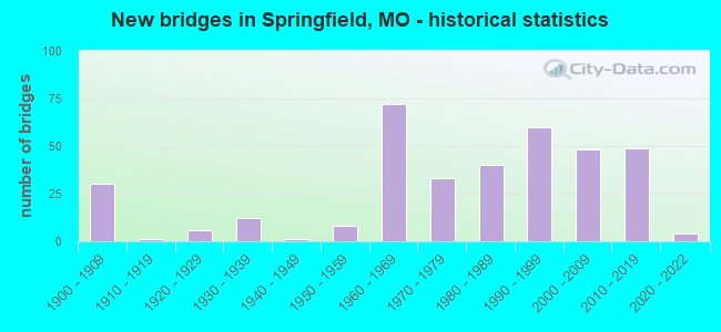
- New bridges - historical statistics
- 301900-1909
- 11910-1919
- 61920-1929
- 121930-1939
- 11940-1949
- 81950-1959
- 721960-1969
- 331970-1979
- 401980-1989
- 601990-1999
- 482000-2009
- 492010-2019
- 42020-2022
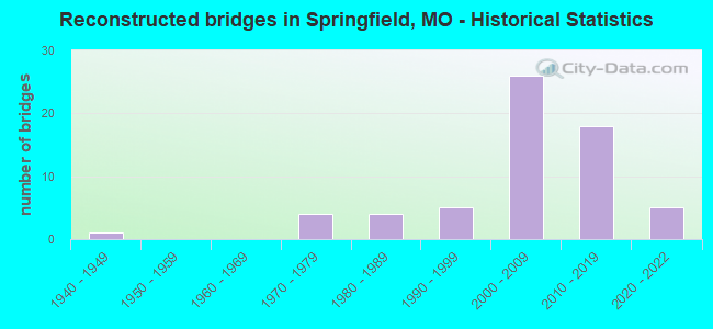
- Reconstructed bridges - Historical Statistics
- 11940-1949
- 01950-1959
- 01960-1969
- 41970-1979
- 41980-1989
- 51990-1999
- 262000-2009
- 182010-2019
- 52020-2022
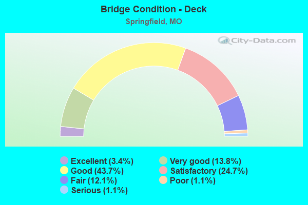
- Bridge Condition - Deck
- 3.4%Excellent
- 13.8%Very good
- 43.7%Good
- 24.7%Satisfactory
- 12.1%Fair
- 1.1%Poor
- 1.1%Serious
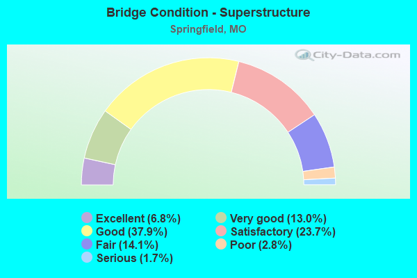
- Bridge Condition - Superstructure
- 6.8%Excellent
- 13.0%Very good
- 37.9%Good
- 23.7%Satisfactory
- 14.1%Fair
- 2.8%Poor
- 1.7%Serious
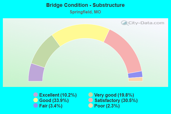
- Bridge Condition - Substructure
- 10.2%Excellent
- 19.8%Very good
- 33.9%Good
- 30.5%Satisfactory
- 3.4%Fair
- 2.3%Poor
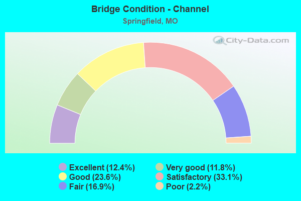
- Bridge Condition - Channel
- 12.4%Excellent
- 11.8%Very good
- 23.6%Good
- 33.1%Satisfactory
- 16.9%Fair
- 2.2%Poor
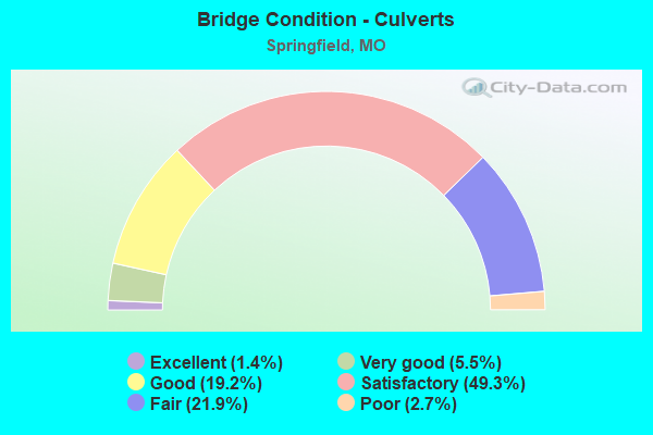
- Bridge Condition - Culverts
- 1.4%Excellent
- 5.5%Very good
- 19.2%Good
- 49.3%Satisfactory
- 21.9%Fair
- 2.7%Poor
Find on map >> Show street view
Structure Number: 36402, Location: S 23 T 28 N R 22 W (Lat: 37.123581, Lng: -93.301044), Route carried "on" structure: City street 407, Year Built: 2011, Status: Open, Structure Length: 1.65m (5.41ft), Average Daily Traffic: 45,000 (year 2020), Truck Traffic: 10%, Average Future Daily Traffic: 67,500 (year 2040), Design Load: HS 20, Features Intersected: WARD BR, Facility Carried by Structure: WEAVER RD
Minimum Vertical Clearance: 30+ m (98+ ft), Kilometerpoint: 0.322, Lanes on structure: 3, Owner: City or Municipal Highway Agency, Approaching Roadway Width: 12.2m (40.0ft), Skew: 2 degrees, Material/Design: Concrete continuous, Design/Construction: Culvert, Number Of Spans In Main Unit: 5, Length of Maximum Span: 3.7m (12.1ft), Curb or Sidewalk Widths: Left: 1.2m (3.9ft), Right: 1.2m (3.9ft), Curb-To-Curb Width: 12.2m (40.0ft), Out-to-Out Width: 25.9m (85.0ft)
Condition: Channel: Satisfactory, Culverts: Good, Operating Rating: 54.0 metric tons, Method Used To Determine Operating Rating: Load Factor (LF), Inventory Rating: 32.4 metric tons, Method Used To Determine Inventory Rating: Load Factor (LF), Structural Evaluation: Better than present minimum criteria, Deck Geometry: Meets minimum limits, Waterway Adequacy: Superior to present desirable criteria, Approach Roadway Alignment: Better than present minimum criteria, Designated Inspection Frequency: Every 24 months, Inspection Date: May 2020
Find on map >> Show street view
Structure Number: 36453, Location: S 8 T 29 N R 21 W (Lat: 37.155556, Lng: -93.357222), Route carried "on" structure: County highway 125, Year Built: 2020, Status: Open, Structure Length: 3.33m (10.93ft), Average Daily Traffic: 124 (year 2020), Truck Traffic: 5%, Average Future Daily Traffic: 186 (year 2040), Design Load: HS 20, Features Intersected: SOUTH BRANCH CREEK, Facility Carried by Structure: BARRINGTON AVENUE
Minimum Vertical Clearance: 30+ m (98+ ft), Kilometerpoint: 29.451, Lanes on structure: 2, Owner: County Highway Agency, Approaching Roadway Width: 8.9m (29.2ft), Skew: 3 degrees, Material/Design: Prestressed concrete continuous, Design/Construction: Stringer/Multi-beam, Number Of Spans In Main Unit: 2, Length of Maximum Span: 16.6m (54.5ft), Curb or Sidewalk Widths: Left: 1.7m (5.6ft), Right: 1.7m (5.6ft), Curb-To-Curb Width: 8.8m (28.9ft), Out-to-Out Width: 11.9m (39.0ft)
Condition: Deck: Excellent, Superstructure: Excellent, Substructure: Excellent, Channel: Excellent, Operating Rating: 81.0 metric tons, Method Used To Determine Operating Rating: Load Factor (LF), Inventory Rating: 48.6 metric tons, Method Used To Determine Inventory Rating: Load Factor (LF), Structural Evaluation: Superior to present desirable criteria, Deck Geometry: Equal to present minimum criteria, Waterway Adequacy: Superior to present desirable criteria, Approach Roadway Alignment: Equal to present desirable criteria, Designated Inspection Frequency: Every 24 months, Inspection Date: August 2020, Deck Structure Type: Concrete Cast-file-Place, Wearing Surface/Protective System: Wearing Surface: Monolithic Concrete, Deck Protection: Epoxy Coated Reinforcing
Find on map >> Show street view
Structure Number: 36455, Location: S 15 T 30 N R 21 W (Lat: 37.320514, Lng: -93.238350), Route carried "on" structure: County highway 66, Year Built: 2018, Status: Open, Structure Length: 0.67m (2.20ft), Average Daily Traffic: 44 (year 2020), Truck Traffic: 10%, Average Future Daily Traffic: 90 (year 2040), Design Load: HS 20, Features Intersected: HICKORY BARREN SPR
Minimum Vertical Clearance: 30+ m (98+ ft), Kilometerpoint: 34.923, Lanes on structure: 2, Owner: County Highway Agency, Approaching Roadway Width: 6.7m (22.0ft), Material/Design: Concrete continuous, Design/Construction: Culvert, Number Of Spans In Main Unit: 2, Length of Maximum Span: 3.0m (9.8ft), Curb-To-Curb Width: 9.8m (32.2ft), Out-to-Out Width: 9.8m (32.2ft)
Condition: Channel: Fair, Culverts: Very good, Operating Rating: 51.3 metric tons, Method Used To Determine Operating Rating: Load Factor (LF), Inventory Rating: 30.6 metric tons, Method Used To Determine Inventory Rating: Load Factor (LF), Structural Evaluation: Better than present minimum criteria, Deck Geometry: Equal to present desirable criteria, Waterway Adequacy: Equal to present minimum criteria, Approach Roadway Alignment: Equal to present minimum criteria, Designated Inspection Frequency: Every 24 months, Inspection Date: January 2021
Find on map >> Show street view
Structure Number: 36457, Location: S 5 T 29 N R 21 W (Lat: 37.260647, Lng: -93.260361), Route carried "on" structure: County highway 167, Year Built: 2018, Status: Open, Structure Length: 0.64m (2.10ft), Average Daily Traffic: 371 (year 2020), Truck Traffic: 10%, Average Future Daily Traffic: 557 (year 2040), Design Load: HS 20, Features Intersected: UNNAMED STREAM
Minimum Vertical Clearance: 30+ m (98+ ft), Kilometerpoint: 17.542, Lanes on structure: 2, Owner: County Highway Agency, Approaching Roadway Width: 6.4m (21.0ft), Material/Design: Concrete continuous, Design/Construction: Culvert, Number Of Spans In Main Unit: 2, Length of Maximum Span: 3.0m (9.8ft), Curb-To-Curb Width: 9.8m (32.2ft), Out-to-Out Width: 9.8m (32.2ft)
Condition: Channel: Good, Culverts: Good, Operating Rating: 92.7 metric tons, Method Used To Determine Operating Rating: Load Factor (LF), Inventory Rating: 55.8 metric tons, Method Used To Determine Inventory Rating: Load Factor (LF), Structural Evaluation: Better than present minimum criteria, Deck Geometry: Better than present minimum criteria, Waterway Adequacy: Equal to present minimum criteria, Approach Roadway Alignment: Equal to present minimum criteria, Designated Inspection Frequency: Every 24 months, Inspection Date: January 2021
Find on map >> Show street view
Structure Number: 36527, Location: S 22 T 28 N R 22 W (Lat: 37.116461, Lng: -93.330350), Route carried "on" structure: County highway 182, Year Built: 1999, Status: Open, Structure Length: 1.11m (3.64ft), Average Daily Traffic: 2,099 (year 2021), Truck Traffic: 10%, Average Future Daily Traffic: 4,303 (year 2041), Design Load: HS 20, Features Intersected: UNNAMED STREAM
Minimum Vertical Clearance: 30+ m (98+ ft), Kilometerpoint: 24.784, Lanes on structure: 3, Owner: County Highway Agency, Approaching Roadway Width: 11.3m (37.1ft), Skew: 2 degrees, Material/Design: Concrete continuous, Design/Construction: Culvert, Number Of Spans In Main Unit: 3, Length of Maximum Span: 3.5m (11.5ft), Curb-To-Curb Width: 11.3m (37.1ft), Out-to-Out Width: 11.3m (37.1ft)
Condition: Channel: Fair, Culverts: Satisfactory, Operating Rating: 63.9 metric tons, Method Used To Determine Operating Rating: Load Factor (LF), Inventory Rating: 38.7 metric tons, Method Used To Determine Inventory Rating: Load Factor (LF), Structural Evaluation: Equal to present minimum criteria, Deck Geometry: High priority of replacement, Waterway Adequacy: Superior to present desirable criteria, Approach Roadway Alignment: Equal to present desirable criteria, Designated Inspection Frequency: Every 24 months, Inspection Date: March 2020
Find on map >> Show street view
Structure Number: 36543, Location: S 4 T 28 N R 22 W (Lat: 37.155894, Lng: -93.341394), Route carried "on" structure: County highway 135, Year Built: 2003, Status: Open, Structure Length: 1.60m (5.25ft), Average Daily Traffic: 4,552 (year 2021), Truck Traffic: 10%, Average Future Daily Traffic: 9,332 (year 2041), Design Load: HS 20, Features Intersected: UNNAMED DRAINAGE
Minimum Vertical Clearance: 30+ m (98+ ft), Kilometerpoint: 29.451, Lanes on structure: 2, Owner: County Highway Agency, Approaching Roadway Width: 10.7m (35.1ft), Material/Design: Concrete continuous, Design/Construction: Culvert, Number Of Spans In Main Unit: 3, Length of Maximum Span: 5.2m (17.1ft)
Condition: Channel: Good, Culverts: Good, Operating Rating: 61.2 metric tons, Method Used To Determine Operating Rating: Load Factor (LF), Inventory Rating: 36.0 metric tons, Method Used To Determine Inventory Rating: Load Factor (LF), Structural Evaluation: Better than present minimum criteria, Waterway Adequacy: Better than present minimum criteria, Approach Roadway Alignment: Equal to present desirable criteria, Designated Inspection Frequency: Every 24 months, Inspection Date: Febuary 2022
Find on map >> Show street view
Structure Number: 36544, Location: S 4 T 28 N R 22 W (Lat: 37.154644, Lng: -93.341431), Route carried "on" structure: County highway 135, Year Built: 2003, Status: Open, Structure Length: 1.10m (3.61ft), Average Daily Traffic: 4,552 (year 2021), Truck Traffic: 10%, Average Future Daily Traffic: 9,332 (year 2041), Design Load: HS 20, Features Intersected: UNNAMED DRAINAGE
Minimum Vertical Clearance: 30+ m (98+ ft), Kilometerpoint: 29.612, Lanes on structure: 2, Owner: County Highway Agency, Approaching Roadway Width: 10.7m (35.1ft), Skew: 3 degrees, Material/Design: Concrete continuous, Design/Construction: Culvert, Number Of Spans In Main Unit: 3, Length of Maximum Span: 3.4m (11.2ft)
Condition: Channel: Satisfactory, Culverts: Good, Structural Evaluation: Better than present minimum criteria, Waterway Adequacy: Better than present minimum criteria, Approach Roadway Alignment: Equal to present desirable criteria, Designated Inspection Frequency: Every 24 months, Inspection Date: Febuary 2022
Find on map >> Show street view
Structure Number: 36545, Location: S 16 T 30 N R 21 W (Lat: 37.316750, Lng: -93.245194), Route carried "on" structure: County highway 171, Year Built: 2007, Status: Open, Structure Length: 0.89m (2.92ft), Average Daily Traffic: 100 (year 2020), Truck Traffic: 10%, Average Future Daily Traffic: 205 (year 2040), Design Load: HS 20, Features Intersected: UNNAMED DRAINAGE
Minimum Vertical Clearance: 30+ m (98+ ft), Kilometerpoint: 11.426, Lanes on structure: 2, Owner: County Highway Agency, Approaching Roadway Width: 7.3m (24.0ft), Skew: 6 degrees, Material/Design: Concrete continuous, Design/Construction: Culvert, Number Of Spans In Main Unit: 2, Length of Maximum Span: 2.1m (6.9ft), Curb-To-Curb Width: 7.3m (24.0ft), Out-to-Out Width: 7.9m (25.9ft)
Condition: Channel: Good, Culverts: Very good, Operating Rating: 98.1 metric tons, Method Used To Determine Operating Rating: Load Factor (LF), Inventory Rating: 58.5 metric tons, Method Used To Determine Inventory Rating: Load Factor (LF), Structural Evaluation: Equal to present desirable criteria, Deck Geometry: Equal to present minimum criteria, Waterway Adequacy: Better than present minimum criteria, Approach Roadway Alignment: Equal to present minimum criteria, Designated Inspection Frequency: Every 24 months, Inspection Date: April 2020
Find on map >> Show street view
Structure Number: 36575, Location: S 15 T 28 N R 22 W (Lat: 37.127944, Lng: -93.331500), Route carried "on" structure: City street 176, Year Built: 2009, Status: Open, Structure Length: 1.06m (3.48ft), Average Daily Traffic: 247 (year 2021), Truck Traffic: 10%, Average Future Daily Traffic: 371 (year 2041), Design Load: HS 20, Features Intersected: DRAIN DITCH, Facility Carried by Structure: ALLEN DR
Minimum Vertical Clearance: 30+ m (98+ ft), Kilometerpoint: 24.301, Lanes on structure: 2, Owner: County Highway Agency, Approaching Roadway Width: 8.2m (26.9ft), Skew: 4 degrees, Material/Design: Concrete continuous, Design/Construction: Culvert, Number Of Spans In Main Unit: 3, Length of Maximum Span: 2.4m (7.9ft), Curb-To-Curb Width: 7.9m (25.9ft), Out-to-Out Width: 31.1m (102.0ft)
Condition: Channel: Very good, Culverts: Very good, Operating Rating: 54.0 metric tons, Method Used To Determine Operating Rating: Load Factor (LF), Inventory Rating: 32.4 metric tons, Method Used To Determine Inventory Rating: Load Factor (LF), Structural Evaluation: Equal to present desirable criteria, Deck Geometry: Somewhat better than minimum adequacy, Waterway Adequacy: Equal to present minimum criteria, Approach Roadway Alignment: Equal to present desirable criteria, Designated Inspection Frequency: Every 24 months, Inspection Date: July 2020, Wearing Surface/Protective System: Wearing Surface: Bituminous
Find on map >> Show street view
Structure Number: 36578, Location: S 24 T 28 N R 22 W (Lat: 37.123528, Lng: -93.288942), Route carried "on" structure: City street 187, Year Built: 2014, Status: Open, Structure Length: 1.23m (4.04ft), Average Daily Traffic: 3,932 (year 2021), Truck Traffic: 20%, Average Future Daily Traffic: 5,898 (year 2041), Design Load: HS 20, Features Intersected: UNNAMED STREAM
Minimum Vertical Clearance: 30+ m (98+ ft), Kilometerpoint: 28.325, Lanes on structure: 3, Owner: County Highway Agency, Approaching Roadway Width: 12.2m (40.0ft), Material/Design: Concrete continuous, Design/Construction: Culvert, Number Of Spans In Main Unit: 3, Length of Maximum Span: 3.7m (12.1ft), Curb or Sidewalk Widths: Left: 1.2m (3.9ft), Right: 1.2m (3.9ft), Curb-To-Curb Width: 12.2m (40.0ft), Out-to-Out Width: 15.2m (49.9ft)
Condition: Channel: Good, Culverts: Good, Inventory Rating: 61.2 metric tons, Method Used To Determine Inventory Rating: Load Factor (LF), Structural Evaluation: Better than present minimum criteria, Deck Geometry: Meets minimum limits, Waterway Adequacy: Equal to present desirable criteria, Approach Roadway Alignment: Equal to present desirable criteria, Designated Inspection Frequency: Every 24 months, Inspection Date: July 2020
Find on map >> Show street view
Structure Number: 3658, Location: S 29 T 28 N R 21 W (Lat: 37.097964, Lng: -93.254767), Route carried "on" structure: County highway 169, Year Built: 2021, Status: Open, Structure Length: 1.71m (5.61ft), Average Daily Traffic: 1,666 (year 2021), Truck Traffic: 10%, Average Future Daily Traffic: 2,499 (year 2041), Design Load: HS 20, Features Intersected: FARMERS BR
Minimum Vertical Clearance: 30+ m (98+ ft), Kilometerpoint: 36.210, Lanes on structure: 2, Owner: County Highway Agency, Approaching Roadway Width: 8.5m (27.9ft), Material/Design: Prestressed concrete, Design/Construction: Box Beam or Girders - Multiple, Number Of Spans In Main Unit: 1, Length of Maximum Span: 16.0m (52.5ft), Curb-To-Curb Width: 8.0m (26.2ft), Out-to-Out Width: 8.6m (28.2ft)
Condition: Deck: Excellent, Superstructure: Excellent, Substructure: Excellent, Channel: Excellent, Operating Rating: 87.3 metric tons, Method Used To Determine Operating Rating: Load Factor (LF), Inventory Rating: 67.5 metric tons, Method Used To Determine Inventory Rating: Load Factor (LF), Structural Evaluation: Superior to present desirable criteria, Deck Geometry: Meets minimum limits, Waterway Adequacy: Equal to present minimum criteria, Approach Roadway Alignment: Equal to present desirable criteria, Designated Inspection Frequency: Every 24 months, Inspection Date: November 2021, Deck Structure Type: Concrete Cast-file-Place, Wearing Surface/Protective System: Wearing Surface: Monolithic Concrete, Membrane: Built-up, Deck Protection: Epoxy Coated Reinforcing
Find on map >> Show street view
Structure Number: 36628, Location: S 22 T 28 N R 22 W (Lat: 37.117714, Lng: -93.316669), Route carried "on" structure: State highway 143, Year Built: 2022, Status: Not yet open, Structure Length: 13.72m (45.01ft), Average Daily Traffic: 16,300 (year 2021), Truck Traffic: 10%, Average Future Daily Traffic: 24,450 (year 2041), Design Load: HS 20, Features Intersected: WARD BR, Facility Carried by Structure: KANSAS EXPRESSWAY
Minimum Vertical Clearance: 30+ m (98+ ft), Kilometerpoint: 4.828, Lanes on structure: 2, Owner: County Highway Agency, Approaching Roadway Width: 9.1m (29.9ft), Skew: 5 degrees, Material/Design: Steel continuous, Design/Construction: Stringer/Multi-beam, Number Of Spans In Main Unit: 4, Length of Maximum Span: 34.3m (112.5ft), Curb or Sidewalk Widths: Left: 3.7m (12.1ft), Right: 0.3m (1.0ft), Curb-To-Curb Width: 9.1m (29.9ft), Out-to-Out Width: 13.1m (43.0ft)
Condition: Deck: Excellent, Superstructure: Excellent, Substructure: Excellent, Channel: Excellent, Operating Rating: 71.1 metric tons, Method Used To Determine Operating Rating: Load Factor (LF), Inventory Rating: 54.9 metric tons, Method Used To Determine Inventory Rating: Load Factor (LF), Structural Evaluation: Superior to present desirable criteria, Deck Geometry: Meets minimum limits, Waterway Adequacy: Superior to present desirable criteria, Approach Roadway Alignment: Equal to present desirable criteria, Designated Inspection Frequency: Every 24 months, Inspection Date: August 2021, Deck Structure Type: Concrete Cast-file-Place
Find on map >> Show street view
Structure Number: 36664, Location: S 15 T 28 N R 22 W (Lat: 37.128056, Lng: -93.316944), Route carried "on" structure: City street 143, Year Built: 2022, Status: Not yet open, Structure Length: 2.06m (6.76ft), Average Daily Traffic: 16,300 (year 2021), Truck Traffic: 10%, Average Future Daily Traffic: 24,450 (year 2041), Features Intersected: WARD BR, Facility Carried by Structure: KANSAS EXPRESSWAY
Minimum Vertical Clearance: 30+ m (98+ ft), Kilometerpoint: 1.609, Lanes on structure: 2, Owner: County Highway Agency, Approaching Roadway Width: 9.1m (29.9ft), Material/Design: Concrete, Design/Construction: Arch - Deck, Number Of Spans In Main Unit: 1, Length of Maximum Span: 20.6m (67.6ft), Curb-To-Curb Width: 9.1m (29.9ft), Out-to-Out Width: 78.6m (257.9ft)
Condition: Deck: Excellent, Superstructure: Excellent, Substructure: Excellent, Channel: Very good, Operating Rating: 54.0 metric tons, Method Used To Determine Operating Rating: Load Factor (LF), Inventory Rating: 32.4 metric tons, Method Used To Determine Inventory Rating: Load Factor (LF), Structural Evaluation: Equal to present desirable criteria, Deck Geometry: High priority of corrective action, Waterway Adequacy: Superior to present desirable criteria, Approach Roadway Alignment: Equal to present desirable criteria, Designated Inspection Frequency: Every 24 months, Inspection Date: December 2021
Find on map >> Show street view
Structure Number: 3708, Location: S 31 T 29 N R 22 W (Lat: 37.176978, Lng: -93.369403), Route carried "on" structure: State highway 413, Year Built: 1986, Status: Open, Structure Length: 6.86m (22.51ft), Average Daily Traffic: 7,447 (year 2021), Truck Traffic: 8%, Average Future Daily Traffic: 11,543 (year 2041), Design Load: HS 20, Features Intersected: WILSON CR
Minimum Vertical Clearance: 30+ m (98+ ft), Kilometerpoint: 4.767, Lanes on structure: 2, Base Highway Network: Yes, Owner: State Highway Agency, Approaching Roadway Width: 12.2m (40.0ft), Skew: 3 degrees, Material/Design: Prestressed concrete continuous, Design/Construction: Stringer/Multi-beam, Number Of Spans In Main Unit: 4, Length of Maximum Span: 18.3m (60.0ft), Curb or Sidewalk Widths: Left: 0.2m (0.7ft), Right: 0.2m (0.7ft), Curb-To-Curb Width: 11.8m (38.7ft), Out-to-Out Width: 12.6m (41.3ft)
Condition: Deck: Good, Superstructure: Satisfactory, Substructure: Good, Channel: Satisfactory, Operating Rating: 69.3 metric tons, Method Used To Determine Operating Rating: Load Factor (LF), Inventory Rating: 36.0 metric tons, Method Used To Determine Inventory Rating: Load Factor (LF), Structural Evaluation: Equal to present minimum criteria, Deck Geometry: Equal to present minimum criteria, Waterway Adequacy: Equal to present desirable criteria, Approach Roadway Alignment: Equal to present desirable criteria, Designated Inspection Frequency: Every 24 months, Inspection Date: August 2020, Deck Structure Type: Concrete Cast-file-Place, Wearing Surface/Protective System: Wearing Surface: Monolithic Concrete, Deck Protection: Epoxy Coated Reinforcing
Find on map >> Show street view
Structure Number: 3857, Location: S 1 T 29 N R 21 W (Lat: 37.250458, Lng: -93.183300), Route carried "on" structure: State highway 744, Year Built: 1990, Status: Open, Structure Length: 7.77m (25.49ft), Average Daily Traffic: 5,396 (year 2021), Truck Traffic: 18%, Average Future Daily Traffic: 8,634 (year 2041), Design Load: HS 20+Mod, Features Intersected: IS 44
Minimum Vertical Clearance: 30+ m (98+ ft), Kilometerpoint: 18.110, Lanes on structure: 2, Lanes under structure: 4, Base Highway Network: Yes, Owner: State Highway Agency, Approaching Roadway Width: 15.2m (49.9ft), Skew: 1 degrees, Material/Design: Steel continuous, Design/Construction: Stringer/Multi-beam, Number Of Spans In Main Unit: 2, Length of Maximum Span: 31.4m (103.0ft), Curb or Sidewalk Widths: Left: 0.2m (0.7ft), Right: 0.2m (0.7ft), Curb-To-Curb Width: 11.8m (38.7ft), Out-to-Out Width: 12.6m (41.3ft)
Condition: Deck: Fair, Superstructure: Good, Substructure: Satisfactory, Operating Rating: 62.1 metric tons, Method Used To Determine Operating Rating: Load Factor (LF), Inventory Rating: 36.9 metric tons, Method Used To Determine Inventory Rating: Load Factor (LF), Structural Evaluation: Equal to present minimum criteria, Deck Geometry: Somewhat better than minimum adequacy, Underclear: Equal to present minimum criteria, Approach Roadway Alignment: Equal to present desirable criteria, Designated Inspection Frequency: Every 24 months, Inspection Date: July 2020, Deck Structure Type: Concrete Cast-file-Place, Wearing Surface/Protective System: Wearing Surface: Other, Deck Protection: Epoxy Coated Reinforcing
Find on map >> Show street view
Structure Number: 427, Location: S 18 T 29 N R 22 W (Lat: 37.212550, Lng: -93.385233), Route carried "on" structure: State highway 266, Year Built: 1960, Year Reconstructed: 2008, Status: Open, Structure Length: 8.38m (27.49ft), Average Daily Traffic: 9,080 (year 2021), Truck Traffic: 10%, Average Future Daily Traffic: 14,074 (year 2041), Design Load: H 20, Features Intersected: IS 44
Minimum Vertical Clearance: 30+ m (98+ ft), Kilometerpoint: 25.967, Lanes on structure: 5, Lanes under structure: 5, Base Highway Network: Yes, Owner: State Highway Agency, Approaching Roadway Width: 18.3m (60.0ft), Skew: 24 degrees, Material/Design: Steel continuous, Design/Construction: Stringer/Multi-beam, Number Of Spans In Main Unit: 4, Length of Maximum Span: 25.6m (84.0ft), Curb-To-Curb Width: 18.3m (60.0ft), Out-to-Out Width: 19.1m (62.7ft)
Condition: Deck: Good, Superstructure: Good, Substructure: Satisfactory, Operating Rating: 72.0 metric tons, Method Used To Determine Operating Rating: Load Factor (LF), Inventory Rating: 43.2 metric tons, Method Used To Determine Inventory Rating: Load Factor (LF), Structural Evaluation: Equal to present minimum criteria, Deck Geometry: High priority of replacement, Underclear: High priority of corrective action, Approach Roadway Alignment: Equal to present desirable criteria, Designated Inspection Frequency: Every 24 months, Inspection Date: August 2020, Deck Structure Type: Concrete Cast-file-Place, Wearing Surface/Protective System: Wearing Surface: Monolithic Concrete, Deck Protection: Epoxy Coated Reinforcing
Find on map >> Show street view
Structure Number: 4417, Location: S 29 T 29 N R 22 W (Lat: 37.195450, Lng: -93.349756), Route carried "on" structure: US 160, Year Built: 1997, Status: Open, Structure Length: 5.88m (19.29ft), Average Daily Traffic: 13,637 (year 2021), Truck Traffic: 5%, Average Future Daily Traffic: 21,137 (year 2041), Design Load: HS 20, Features Intersected: WILSON CR
Minimum Vertical Clearance: 30+ m (98+ ft), Kilometerpoint: 372.062, Lanes on structure: 2, Base Highway Network: Yes, Owner: State Highway Agency, Approaching Roadway Width: 12.2m (40.0ft), Material/Design: Prestressed concrete, Design/Construction: Stringer/Multi-beam, Number Of Spans In Main Unit: 4, Length of Maximum Span: 14.8m (48.6ft), Curb-To-Curb Width: 11.2m (36.7ft), Out-to-Out Width: 13.7m (44.9ft)
Condition: Deck: Good, Superstructure: Good, Substructure: Very good, Channel: Satisfactory, Operating Rating: 81.9 metric tons, Method Used To Determine Operating Rating: Load Factor (LF), Inventory Rating: 48.6 metric tons, Method Used To Determine Inventory Rating: Load Factor (LF), Structural Evaluation: Better than present minimum criteria, Deck Geometry: Somewhat better than minimum adequacy, Waterway Adequacy: Superior to present desirable criteria, Approach Roadway Alignment: Equal to present desirable criteria, Designated Inspection Frequency: Every 24 months, Inspection Date: August 2020, Deck Structure Type: Concrete Cast-file-Place, Wearing Surface/Protective System: Wearing Surface: Monolithic Concrete, Deck Protection: Epoxy Coated Reinforcing
Find on map >> Show street view
Structure Number: 4418, Location: S 29 T 29 N R 22 W (Lat: 37.195533, Lng: -93.349906), Route carried "on" structure: US 160, Year Built: 1997, Status: Open, Structure Length: 5.88m (19.29ft), Average Daily Traffic: 14,013 (year 2021), Truck Traffic: 7%, Average Future Daily Traffic: 21,720 (year 2041), Design Load: HS 20, Features Intersected: WILSON CR
Minimum Vertical Clearance: 30+ m (98+ ft), Kilometerpoint: 148.501, Lanes on structure: 2, Base Highway Network: Yes, Owner: State Highway Agency, Approaching Roadway Width: 12.2m (40.0ft), Material/Design: Prestressed concrete, Design/Construction: Stringer/Multi-beam, Number Of Spans In Main Unit: 4, Length of Maximum Span: 14.8m (48.6ft), Curb-To-Curb Width: 11.2m (36.7ft), Out-to-Out Width: 13.7m (44.9ft)
Condition: Deck: Very good, Superstructure: Good, Substructure: Very good, Channel: Satisfactory, Operating Rating: 81.9 metric tons, Method Used To Determine Operating Rating: Load Factor (LF), Inventory Rating: 48.6 metric tons, Method Used To Determine Inventory Rating: Load Factor (LF), Structural Evaluation: Better than present minimum criteria, Deck Geometry: Somewhat better than minimum adequacy, Waterway Adequacy: Superior to present desirable criteria, Approach Roadway Alignment: Equal to present desirable criteria, Designated Inspection Frequency: Every 24 months, Inspection Date: August 2020, Deck Structure Type: Concrete Cast-file-Place, Wearing Surface/Protective System: Wearing Surface: Monolithic Concrete, Deck Protection: Epoxy Coated Reinforcing
Find on map >> Show street view
Structure Number: 5006, Location: S 7 T 29 N R 21 W (Lat: 37.226147, Lng: -93.261356), Route carried "on" structure: Business State highway 44, Year Built: 1927, Year Reconstructed: 1949, Status: Open, Structure Length: 0.76m (2.49ft), Average Daily Traffic: 31,933 (year 2021), Truck Traffic: 5%, Average Future Daily Traffic: 51,093 (year 2041), Design Load: H 20, Features Intersected: JORDAN CR
Minimum Vertical Clearance: 30+ m (98+ ft), Kilometerpoint: 12.653, Lanes on structure: 7, Base Highway Network: Yes, Owner: State Highway Agency, Approaching Roadway Width: 13.4m (44.0ft), Material/Design: Concrete continuous, Design/Construction: Culvert, Number Of Spans In Main Unit: 2, Length of Maximum Span: 3.7m (12.1ft)
Condition: Channel: Satisfactory, Culverts: Satisfactory, Operating Rating: 67.5 metric tons, Method Used To Determine Operating Rating: Load Factor (LF), Inventory Rating: 40.5 metric tons, Method Used To Determine Inventory Rating: Load Factor (LF), Structural Evaluation: Equal to present minimum criteria, Waterway Adequacy: Equal to present desirable criteria, Approach Roadway Alignment: Equal to present desirable criteria, Designated Inspection Frequency: Every 24 months, Inspection Date: January 2021
Find on map >> Show street view
Structure Number: 517, Location: S 7 T 29 N R 22 W (Lat: 37.227064, Lng: -93.369108), Route carried "on" structure: State highway EE, Year Built: 1961, Status: Posted for load, Structure Length: 8.56m (28.08ft), Average Daily Traffic: 7,007 (year 2021), Truck Traffic: 11%, Average Future Daily Traffic: 11,211 (year 2041), Design Load: H 20, Features Intersected: IS 44
Minimum Vertical Clearance: 30+ m (98+ ft), Kilometerpoint: 11.727, Lanes on structure: 2, Lanes under structure: 4, Owner: State Highway Agency, Approaching Roadway Width: 6.4m (21.0ft), Skew: 4 degrees, Material/Design: Steel continuous, Design/Construction: Stringer/Multi-beam, Number Of Spans In Main Unit: 4, Length of Maximum Span: 22.9m (75.1ft), Curb-To-Curb Width: 7.9m (25.9ft), Out-to-Out Width: 9.8m (32.2ft)
Condition: Deck: Fair, Superstructure: Good, Substructure: Satisfactory, Operating Rating: 37.8 metric tons, Method Used To Determine Operating Rating: Load Factor (LF), Inventory Rating: 22.5 metric tons, Method Used To Determine Inventory Rating: Load Factor (LF), Structural Evaluation: Somewhat better than minimum adequacy, Deck Geometry: High priority of corrective action, Underclear: Somewhat better than minimum adequacy, Approach Roadway Alignment: Equal to present desirable criteria, Length Of Structure Improvement: 0.96m (3.15ft), Designated Inspection Frequency: Every 24 months, Inspection Date: August 2020, Bridge Improvement Cost: $822,000, Roadway Improvement Cost: $82,000, Total Project Cost: $1,234,000 ( Estimate for 2022), Deck Structure Type: Concrete Cast-file-Place, Wearing Surface/Protective System: Wearing Surface: Bituminous
Find on map >> Show street view
Structure Number: 5586, Location: S 25 T 28 N R 22 W (Lat: 37.098011, Lng: -93.297742), Route carried "on" structure: US 160, Year Built: 1964, Year Reconstructed: 1983, Status: Posted for load, Structure Length: 6.98m (22.90ft), Average Daily Traffic: 14,654 (year 2021), Truck Traffic: 9%, Average Future Daily Traffic: 22,714 (year 2041), Design Load: HS 20, Features Intersected: JAMES RVR OVERFLOW
Minimum Vertical Clearance: 30+ m (98+ ft), Kilometerpoint: 164.618, Lanes on structure: 2, Base Highway Network: Yes, Owner: State Highway Agency, Approaching Roadway Width: 12.2m (40.0ft), Skew: 10 degrees, Material/Design: Steel continuous, Design/Construction: Stringer/Multi-beam, Number Of Spans In Main Unit: 4, Length of Maximum Span: 19.2m (63.0ft), Curb-To-Curb Width: 9.4m (30.8ft), Out-to-Out Width: 9.6m (31.5ft)
Condition: Deck: Fair, Superstructure: Good, Substructure: Good, Channel: Good, Operating Rating: 47.7 metric tons, Method Used To Determine Operating Rating: Load Factor (LF), Inventory Rating: 28.8 metric tons, Method Used To Determine Inventory Rating: Load Factor (LF), Structural Evaluation: Better than present minimum criteria, Deck Geometry: Meets minimum limits, Waterway Adequacy: Equal to present minimum criteria, Approach Roadway Alignment: Equal to present desirable criteria, Designated Inspection Frequency: Every 24 months, Inspection Date: August 2020, Deck Structure Type: Concrete Cast-file-Place, Wearing Surface/Protective System: Wearing Surface: Bituminous, Membrane: Built-up
Find on map >> Show street view
Structure Number: 559, Location: S 15 T 29 N R 22 W (Lat: 37.212283, Lng: -93.329694), Route carried "on" structure: Business State highway 44, Year Built: 1960, Status: Open, Structure Length: 0.69m (2.26ft), Average Daily Traffic: 20,683 (year 2021), Truck Traffic: 5%, Average Future Daily Traffic: 32,059 (year 2041), Design Load: H 20, Features Intersected: DITCH
Minimum Vertical Clearance: 30+ m (98+ ft), Kilometerpoint: 5.216, Lanes on structure: 4, Base Highway Network: Yes, Owner: State Highway Agency, Approaching Roadway Width: 20.7m (67.9ft), Skew: 25 degrees, Material/Design: Concrete continuous, Design/Construction: Culvert, Number Of Spans In Main Unit: 2, Length of Maximum Span: 2.1m (6.9ft)
Condition: Channel: Excellent, Culverts: Satisfactory, Operating Rating: 47.7 metric tons, Method Used To Determine Operating Rating: Load Factor (LF), Inventory Rating: 28.8 metric tons, Method Used To Determine Inventory Rating: Load Factor (LF), Structural Evaluation: Equal to present minimum criteria, Waterway Adequacy: Equal to present desirable criteria, Approach Roadway Alignment: Equal to present desirable criteria, Designated Inspection Frequency: Every 24 months, Inspection Date: January 2021
Find on map >> Show street view
Structure Number: 5802, Location: S 14 T 29 N R 22 W (Lat: 37.214161, Lng: -93.306083), Route carried "on" structure: Business State highway 44, Year Built: 1933, Status: Open, Structure Length: 0.93m (3.05ft), Average Daily Traffic: 23,542 (year 2021), Truck Traffic: 5%, Average Future Daily Traffic: 36,490 (year 2041), Features Intersected: JORDON CR
Minimum Vertical Clearance: 30+ m (98+ ft), Kilometerpoint: 7.397, Lanes on structure: 4, Base Highway Network: Yes, Owner: State Highway Agency, Approaching Roadway Width: 15.8m (51.8ft), Skew: 21 degrees, Material/Design: Concrete continuous, Design/Construction: Culvert, Number Of Spans In Main Unit: 2, Length of Maximum Span: 4.4m (14.4ft), Curb or Sidewalk Widths: Left: 1.5m (4.9ft), Right: 1.5m (4.9ft)
Condition: Channel: Satisfactory, Culverts: Good, Operating Rating: 24.3 metric tons, Method Used To Determine Operating Rating: Field evaluation and documented engineering judgment, Inventory Rating: 14.4 metric tons, Method Used To Determine Inventory Rating: Field evaluation and documented engineering judgment, Structural Evaluation: High priority of replacement, Waterway Adequacy: Equal to present desirable criteria, Approach Roadway Alignment: Equal to present desirable criteria, Length Of Structure Improvement: 0.16m (0.52ft), Designated Inspection Frequency: Every 24 months, Inspection Date: January 2021, Bridge Improvement Cost: $250,000, Roadway Improvement Cost: $25,000, Total Project Cost: $375,000 ( Estimate for 2022)
Find on map >> Show street view
Structure Number: 5869, Location: S 18 T 29 N R 21 W (Lat: 37.211303, Lng: -93.261839), Route carried "on" structure: Business State highway 65, Year Built: 1938, Year Reconstructed: 1987, Status: Open, Structure Length: 25.12m (82.41ft), Average Daily Traffic: 31,959 (year 2021), Truck Traffic: 5%, Average Future Daily Traffic: 51,134 (year 2041), Design Load: HS 20+Mod, Features Intersected: CST EAST TRFY, BNSF RR,
Minimum Vertical Clearance: 30+ m (98+ ft), Kilometerpoint: 3.700, Lanes on structure: 4, Lanes under structure: 3, Base Highway Network: Yes, Owner: State Highway Agency, Approaching Roadway Width: 17.1m (56.1ft), Material/Design: Prestressed concrete continuous, Design/Construction: Stringer/Multi-beam, Number Of Spans In Main Unit: 11, Length of Maximum Span: 16.0m (52.5ft), Curb or Sidewalk Widths: Left: 0.2m (0.7ft), Right: 0.2m (0.7ft), Curb-To-Curb Width: 17.1m (56.1ft), Out-to-Out Width: 17.9m (58.7ft)
Condition: Deck: Good, Superstructure: Fair, Substructure: Satisfactory, Channel: Fair, Operating Rating: 68.4 metric tons, Method Used To Determine Operating Rating: Load Factor (LF), Inventory Rating: 36.9 metric tons, Method Used To Determine Inventory Rating: Load Factor (LF), Structural Evaluation: Somewhat better than minimum adequacy, Deck Geometry: Somewhat better than minimum adequacy, Underclear: Equal to present minimum criteria, Waterway Adequacy: Superior to present desirable criteria, Approach Roadway Alignment: Equal to present desirable criteria, Designated Inspection Frequency: Every 24 months, Inspection Date: July 2020, Deck Structure Type: Concrete Cast-file-Place, Wearing Surface/Protective System: Wearing Surface: Monolithic Concrete, Deck Protection: Epoxy Coated Reinforcing
Find on map >> Show street view
Structure Number: 5922, Location: S 17 T 29 N R 22 W (Lat: 37.212261, Lng: -93.351892), Route carried "on" structure: Business State highway 44, Year Built: 1938, Year Reconstructed: 2000, Status: Open, Structure Length: 0.67m (2.20ft), Average Daily Traffic: 16,948 (year 2021), Truck Traffic: 5%, Average Future Daily Traffic: 27,117 (year 2041), Design Load: H 15, Features Intersected: N BR WILSON'S CR
Minimum Vertical Clearance: 30+ m (98+ ft), Kilometerpoint: 3.235, Lanes on structure: 5, Base Highway Network: Yes, Owner: State Highway Agency, Approaching Roadway Width: 18.0m (59.1ft), Material/Design: Concrete continuous, Design/Construction: Culvert, Number Of Spans In Main Unit: 2, Length of Maximum Span: 3.2m (10.5ft)
Condition: Channel: Good, Culverts: Fair, Operating Rating: 24.3 metric tons, Method Used To Determine Operating Rating: Field evaluation and documented engineering judgment, Inventory Rating: 14.4 metric tons, Method Used To Determine Inventory Rating: Field evaluation and documented engineering judgment, Structural Evaluation: High priority of replacement, Waterway Adequacy: Equal to present desirable criteria, Approach Roadway Alignment: Equal to present desirable criteria, Length Of Structure Improvement: 0.13m (0.43ft), Designated Inspection Frequency: Every 24 months, Inspection Date: January 2021, Bridge Improvement Cost: $250,000, Roadway Improvement Cost: $25,000, Total Project Cost: $375,000 ( Estimate for 2022)
Find on map >> Show street view
Structure Number: 6175, Location: S 13 T 28 N R 22 W (Lat: 37.126272, Lng: -93.296519), Route carried "on" structure: US 160, Year Built: 1947, Year Reconstructed: 1983, Status: Open, Structure Length: 0.98m (3.22ft), Average Daily Traffic: 44,648 (year 2021), Truck Traffic: 3%, Average Future Daily Traffic: 69,204 (year 2041), Design Load: H 20, Features Intersected: WARD BR
Minimum Vertical Clearance: 30+ m (98+ ft), Kilometerpoint: 161.548, Lanes on structure: 6, Base Highway Network: Yes, Owner: State Highway Agency, Approaching Roadway Width: 32.9m (107.9ft), Skew: 4 degrees, Material/Design: Concrete continuous, Design/Construction: Culvert, Number Of Spans In Main Unit: 2, Length of Maximum Span: 3.4m (11.2ft)
Condition: Channel: Good, Culverts: Satisfactory, Operating Rating: 94.5 metric tons, Method Used To Determine Operating Rating: Load Factor (LF), Inventory Rating: 56.7 metric tons, Method Used To Determine Inventory Rating: Load Factor (LF), Structural Evaluation: Equal to present minimum criteria, Waterway Adequacy: Equal to present desirable criteria, Approach Roadway Alignment: Equal to present desirable criteria, Designated Inspection Frequency: Every 24 months, Inspection Date: January 2021
Find on map >> Show street view
Structure Number: 6273, Location: S 20 T 29 N R 22 W (Lat: 37.205289, Lng: -93.349469), Route carried "on" structure: US 160, Year Built: 1952, Year Reconstructed: 1997, Status: Open, Structure Length: 1.19m (3.90ft), Average Daily Traffic: 21,843 (year 2021), Truck Traffic: 7%, Average Future Daily Traffic: 33,857 (year 2041), Design Load: HS 20, Features Intersected: WILSON CR
Minimum Vertical Clearance: 30+ m (98+ ft), Kilometerpoint: 147.437, Lanes on structure: 5, Base Highway Network: Yes, Owner: State Highway Agency, Approaching Roadway Width: 42.1m (138.1ft), Skew: 1 degrees, Material/Design: Concrete continuous, Design/Construction: Culvert, Number Of Spans In Main Unit: 3, Length of Maximum Span: 3.7m (12.1ft)
Condition: Channel: Fair, Culverts: Satisfactory, Operating Rating: 72.0 metric tons, Method Used To Determine Operating Rating: Field evaluation and documented engineering judgment, Inventory Rating: 43.2 metric tons, Method Used To Determine Inventory Rating: Field evaluation and documented engineering judgment, Structural Evaluation: Equal to present minimum criteria, Waterway Adequacy: Equal to present desirable criteria, Approach Roadway Alignment: Equal to present desirable criteria, Designated Inspection Frequency: Every 24 months, Inspection Date: January 2021
Find on map >> Show street view
Structure Number: 6274, Location: S 29 T 29 N R 22 W (Lat: 37.196781, Lng: -93.349861), Route carried "on" structure: US 160, Year Built: 1952, Year Reconstructed: 1997, Status: Open, Structure Length: 1.27m (4.17ft), Average Daily Traffic: 27,650 (year 2021), Truck Traffic: 7%, Average Future Daily Traffic: 42,858 (year 2041), Design Load: HS 20, Features Intersected: WILSON CR
Minimum Vertical Clearance: 30+ m (98+ ft), Kilometerpoint: 148.380, Lanes on structure: 4, Base Highway Network: Yes, Owner: State Highway Agency, Approaching Roadway Width: 7.3m (24.0ft), Skew: 2 degrees, Material/Design: Concrete continuous, Design/Construction: Culvert, Number Of Spans In Main Unit: 3, Length of Maximum Span: 3.7m (12.1ft)
Condition: Channel: Satisfactory, Culverts: Satisfactory, Operating Rating: 82.8 metric tons, Method Used To Determine Operating Rating: Load Factor (LF), Inventory Rating: 49.5 metric tons, Method Used To Determine Inventory Rating: Load Factor (LF), Structural Evaluation: Equal to present minimum criteria, Waterway Adequacy: Equal to present desirable criteria, Approach Roadway Alignment: Equal to present desirable criteria, Designated Inspection Frequency: Every 24 months, Inspection Date: January 2021
Find on map >> Show street view
Structure Number: 6372, Location: S 311 T 29 N R 22 W (Lat: 37.176675, Lng: -93.369544), Route carried "on" structure: State highway 413, Year Built: 1954, Year Reconstructed: 2007, Status: Open, Structure Length: 6.83m (22.41ft), Average Daily Traffic: 7,785 (year 2021), Truck Traffic: 4%, Average Future Daily Traffic: 12,067 (year 2041), Design Load: HS 20, Features Intersected: WILSON CR
Minimum Vertical Clearance: 30+ m (98+ ft), Kilometerpoint: 73.584, Lanes on structure: 2, Base Highway Network: Yes, Owner: State Highway Agency, Approaching Roadway Width: 12.2m (40.0ft), Skew: 13 degrees, Material/Design: Steel continuous, Design/Construction: Stringer/Multi-beam, Number Of Spans In Main Unit: 4, Length of Maximum Span: 18.3m (60.0ft), Curb-To-Curb Width: 9.1m (29.9ft), Out-to-Out Width: 10.0m (32.8ft)
Condition: Deck: Good, Superstructure: Good, Substructure: Satisfactory, Channel: Satisfactory, Operating Rating: 65.7 metric tons, Method Used To Determine Operating Rating: Load Factor (LF), Inventory Rating: 39.6 metric tons, Method Used To Determine Inventory Rating: Load Factor (LF), Structural Evaluation: Equal to present minimum criteria, Deck Geometry: Meets minimum limits, Waterway Adequacy: Equal to present minimum criteria, Approach Roadway Alignment: Equal to present desirable criteria, Designated Inspection Frequency: Every 24 months, Inspection Date: August 2020, Deck Structure Type: Concrete Cast-file-Place, Wearing Surface/Protective System: Wearing Surface: Monolithic Concrete, Deck Protection: Epoxy Coated Reinforcing
Find on map >> Show street view
Structure Number: 768, Location: S 2 T 29 N R 22 W (Lat: 37.250203, Lng: -93.301658), Route carried "on" structure: Interstate 44, Year Built: 1960, Year Reconstructed: 2010, Status: Posted for load, Structure Length: 4.11m (13.48ft), Average Daily Traffic: 24,498 (year 2021), Truck Traffic: 28%, Average Future Daily Traffic: 37,972 (year 2041), Design Load: HS 20, Features Intersected: CST BROADWAY AVE
Minimum Vertical Clearance: 30+ m (98+ ft), Kilometerpoint: 125.851, Lanes on structure: 2, Lanes under structure: 2, Base Highway Network: Yes, Owner: State Highway Agency, Approaching Roadway Width: 11.6m (38.1ft), Skew: 10 degrees, Material/Design: Concrete continuous, Design/Construction: Slab, Number Of Spans In Main Unit: 3, Length of Maximum Span: 17.1m (56.1ft), Curb-To-Curb Width: 12.2m (40.0ft), Out-to-Out Width: 13.4m (44.0ft)
Condition: Deck: Fair, Superstructure: Fair, Substructure: Good, Operating Rating: 51.3 metric tons, Method Used To Determine Operating Rating: Load Factor (LF), Inventory Rating: 30.6 metric tons, Method Used To Determine Inventory Rating: Load Factor (LF), Structural Evaluation: Somewhat better than minimum adequacy, Deck Geometry: Better than present minimum criteria, Underclear: Meets minimum limits, Approach Roadway Alignment: Equal to present desirable criteria, Designated Inspection Frequency: Every 24 months, Inspection Date: August 2020, Deck Structure Type: Concrete Cast-file-Place, Wearing Surface/Protective System: Wearing Surface: Other
Find on map >> Show street view
Structure Number: 769, Location: S 2 T 29 N R 22 W (Lat: 37.250403, Lng: -93.301622), Route carried "on" structure: Interstate 44, Year Built: 1960, Year Reconstructed: 2010, Status: Posted for load, Structure Length: 4.11m (13.48ft), Average Daily Traffic: 23,787 (year 2021), Truck Traffic: 27%, Average Future Daily Traffic: 36,870 (year 2041), Design Load: HS 20, Features Intersected: CST BROADWAY AVE
Minimum Vertical Clearance: 30+ m (98+ ft), Kilometerpoint: 345.903, Lanes on structure: 2, Lanes under structure: 2, Base Highway Network: Yes, Owner: State Highway Agency, Approaching Roadway Width: 11.6m (38.1ft), Skew: 10 degrees, Material/Design: Concrete continuous, Design/Construction: Slab, Number Of Spans In Main Unit: 3, Length of Maximum Span: 17.1m (56.1ft), Curb-To-Curb Width: 12.2m (40.0ft), Out-to-Out Width: 13.4m (44.0ft)
Condition: Deck: Fair, Superstructure: Fair, Substructure: Good, Operating Rating: 51.3 metric tons, Method Used To Determine Operating Rating: Load Factor (LF), Inventory Rating: 30.6 metric tons, Method Used To Determine Inventory Rating: Load Factor (LF), Structural Evaluation: Somewhat better than minimum adequacy, Deck Geometry: Better than present minimum criteria, Underclear: Meets minimum limits, Approach Roadway Alignment: Equal to present desirable criteria, Designated Inspection Frequency: Every 24 months, Inspection Date: August 2020, Deck Structure Type: Concrete Cast-file-Place, Wearing Surface/Protective System: Wearing Surface: Other
Find on map >> Show street view
Structure Number: 77, Location: S 2 T 29 N R 22 W (Lat: 37.250197, Lng: -93.297169), Route carried "on" structure: Interstate 44, Year Built: 1960, Year Reconstructed: 2010, Status: Posted for load, Structure Length: 4.24m (13.91ft), Average Daily Traffic: 24,498 (year 2021), Truck Traffic: 28%, Average Future Daily Traffic: 37,972 (year 2041), Design Load: HS 20, Features Intersected: CST GRANT AVE
Minimum Vertical Clearance: 30+ m (98+ ft), Kilometerpoint: 126.245, Lanes on structure: 2, Lanes under structure: 2, Base Highway Network: Yes, Owner: State Highway Agency, Approaching Roadway Width: 11.6m (38.1ft), Skew: 10 degrees, Material/Design: Concrete continuous, Design/Construction: Slab, Number Of Spans In Main Unit: 3, Length of Maximum Span: 18.3m (60.0ft), Curb-To-Curb Width: 12.2m (40.0ft), Out-to-Out Width: 13.4m (44.0ft)
Condition: Deck: Fair, Superstructure: Fair, Substructure: Good, Operating Rating: 57.6 metric tons, Method Used To Determine Operating Rating: Load Factor (LF), Inventory Rating: 34.2 metric tons, Method Used To Determine Inventory Rating: Load Factor (LF), Structural Evaluation: Somewhat better than minimum adequacy, Deck Geometry: Better than present minimum criteria, Underclear: Meets minimum limits, Approach Roadway Alignment: Equal to present desirable criteria, Designated Inspection Frequency: Every 24 months, Inspection Date: August 2020, Deck Structure Type: Concrete Cast-file-Place, Wearing Surface/Protective System: Wearing Surface: Other
Find on map >> Show street view
Structure Number: 771, Location: S 2 T 29 N R 22 W (Lat: 37.250389, Lng: -93.297122), Route carried "on" structure: Interstate 44, Year Built: 1960, Year Reconstructed: 2010, Status: Posted for load, Structure Length: 4.24m (13.91ft), Average Daily Traffic: 23,787 (year 2021), Truck Traffic: 27%, Average Future Daily Traffic: 36,870 (year 2041), Design Load: HS 20, Features Intersected: CST GRANT AVE
Minimum Vertical Clearance: 30+ m (98+ ft), Kilometerpoint: 345.501, Lanes on structure: 2, Lanes under structure: 2, Base Highway Network: Yes, Owner: State Highway Agency, Approaching Roadway Width: 11.6m (38.1ft), Skew: 10 degrees, Material/Design: Concrete continuous, Design/Construction: Slab, Number Of Spans In Main Unit: 3, Length of Maximum Span: 18.3m (60.0ft), Curb-To-Curb Width: 12.2m (40.0ft), Out-to-Out Width: 13.4m (44.0ft)
Condition: Deck: Fair, Superstructure: Fair, Substructure: Good, Operating Rating: 57.6 metric tons, Method Used To Determine Operating Rating: Load Factor (LF), Inventory Rating: 34.2 metric tons, Method Used To Determine Inventory Rating: Load Factor (LF), Structural Evaluation: Somewhat better than minimum adequacy, Deck Geometry: Better than present minimum criteria, Underclear: Meets minimum limits, Approach Roadway Alignment: Equal to present desirable criteria, Designated Inspection Frequency: Every 24 months, Inspection Date: August 2020, Deck Structure Type: Concrete Cast-file-Place, Wearing Surface/Protective System: Wearing Surface: Other
Find on map >> Show street view
Structure Number: 772, Location: S 1 T 29 N R 22 W (Lat: 37.250214, Lng: -93.274406), Route carried "on" structure: Interstate 44, Year Built: 1960, Year Reconstructed: 2010, Status: Posted for load, Structure Length: 4.11m (13.48ft), Average Daily Traffic: 24,498 (year 2021), Truck Traffic: 28%, Average Future Daily Traffic: 37,972 (year 2041), Design Load: HS 20, Features Intersected: CST NATIONAL AVE
Minimum Vertical Clearance: 30+ m (98+ ft), Kilometerpoint: 128.267, Lanes on structure: 2, Lanes under structure: 3, Base Highway Network: Yes, Owner: State Highway Agency, Approaching Roadway Width: 11.6m (38.1ft), Material/Design: Concrete continuous, Design/Construction: Slab, Number Of Spans In Main Unit: 3, Length of Maximum Span: 17.1m (56.1ft), Curb-To-Curb Width: 12.2m (40.0ft), Out-to-Out Width: 13.4m (44.0ft)
Condition: Deck: Satisfactory, Superstructure: Satisfactory, Substructure: Good, Operating Rating: 45.0 metric tons, Method Used To Determine Operating Rating: Load Factor (LF), Inventory Rating: 27.0 metric tons, Method Used To Determine Inventory Rating: Load Factor (LF), Structural Evaluation: Equal to present minimum criteria, Deck Geometry: Better than present minimum criteria, Underclear: Equal to present minimum criteria, Approach Roadway Alignment: Equal to present desirable criteria, Designated Inspection Frequency: Every 24 months, Inspection Date: August 2020, Deck Structure Type: Concrete Cast-file-Place, Wearing Surface/Protective System: Wearing Surface: Other
Find on map >> Show street view
Structure Number: 773, Location: S 1 T 29 N R 22 W (Lat: 37.250394, Lng: -93.274344), Route carried "on" structure: Interstate 44, Year Built: 1960, Year Reconstructed: 2010, Status: Posted for load, Structure Length: 4.11m (13.48ft), Average Daily Traffic: 23,787 (year 2021), Truck Traffic: 27%, Average Future Daily Traffic: 36,870 (year 2041), Design Load: HS 20, Features Intersected: CST NATIONAL AVE
Minimum Vertical Clearance: 30+ m (98+ ft), Kilometerpoint: 343.481, Lanes on structure: 2, Lanes under structure: 3, Base Highway Network: Yes, Owner: State Highway Agency, Approaching Roadway Width: 11.6m (38.1ft), Material/Design: Concrete continuous, Design/Construction: Slab, Number Of Spans In Main Unit: 3, Length of Maximum Span: 17.1m (56.1ft), Curb-To-Curb Width: 12.2m (40.0ft), Out-to-Out Width: 13.4m (44.0ft)
Condition: Deck: Satisfactory, Superstructure: Satisfactory, Substructure: Good, Operating Rating: 45.0 metric tons, Method Used To Determine Operating Rating: Load Factor (LF), Inventory Rating: 27.0 metric tons, Method Used To Determine Inventory Rating: Load Factor (LF), Structural Evaluation: Equal to present minimum criteria, Deck Geometry: Better than present minimum criteria, Underclear: Equal to present minimum criteria, Approach Roadway Alignment: Equal to present desirable criteria, Designated Inspection Frequency: Every 24 months, Inspection Date: August 2020, Deck Structure Type: Concrete Cast-file-Place, Wearing Surface/Protective System: Wearing Surface: Other
Find on map >> Show street view
Structure Number: 79, Location: S 18 T 29 N R 22 W (Lat: 37.220936, Lng: -93.375811), Route carried "on" structure: Interstate 44, Year Built: 1961, Year Reconstructed: 1996, Status: Posted for load, Structure Length: 4.82m (15.81ft), Average Daily Traffic: 15,503 (year 2021), Truck Traffic: 18%, Average Future Daily Traffic: 24,030 (year 2041), Design Load: HS 20, Features Intersected: BNSF RR
Minimum Vertical Clearance: 30+ m (98+ ft), Kilometerpoint: 117.849, Lanes on structure: 2, Base Highway Network: Yes, Owner: State Highway Agency, Approaching Roadway Width: 12.2m (40.0ft), Skew: 3 degrees, Material/Design: Steel continuous, Design/Construction: Stringer/Multi-beam, Number Of Spans In Main Unit: 3, Length of Maximum Span: 17.7m (58.1ft), Curb-To-Curb Width: 11.4m (37.4ft), Out-to-Out Width: 12.2m (40.0ft)
Condition: Deck: Satisfactory, Superstructure: Good, Substructure: Good, Operating Rating: 51.3 metric tons, Method Used To Determine Operating Rating: Load Factor (LF), Inventory Rating: 30.6 metric tons, Method Used To Determine Inventory Rating: Load Factor (LF), Structural Evaluation: Better than present minimum criteria, Deck Geometry: Somewhat better than minimum adequacy, Underclear: Superior to present desirable criteria, Approach Roadway Alignment: Equal to present desirable criteria, Designated Inspection Frequency: Every 24 months, Inspection Date: August 2020, Deck Structure Type: Concrete Cast-file-Place, Wearing Surface/Protective System: Wearing Surface: Low Slump Concrete
Find on map >> Show street view
Structure Number: 791, Location: S 16 T 29 N R 22 W (Lat: 37.220894, Lng: -93.376164), Route carried "on" structure: Interstate 44, Year Built: 1961, Year Reconstructed: 1996, Status: Posted for load, Structure Length: 4.82m (15.81ft), Average Daily Traffic: 14,937 (year 2021), Truck Traffic: 18%, Average Future Daily Traffic: 23,152 (year 2041), Design Load: HS 20, Features Intersected: BNSF RR
Minimum Vertical Clearance: 30+ m (98+ ft), Kilometerpoint: 353.936, Lanes on structure: 2, Base Highway Network: Yes, Owner: State Highway Agency, Approaching Roadway Width: 12.2m (40.0ft), Skew: 3 degrees, Material/Design: Steel continuous, Design/Construction: Stringer/Multi-beam, Number Of Spans In Main Unit: 3, Length of Maximum Span: 17.7m (58.1ft), Curb-To-Curb Width: 11.4m (37.4ft), Out-to-Out Width: 12.2m (40.0ft)
Condition: Deck: Satisfactory, Superstructure: Good, Substructure: Satisfactory, Operating Rating: 51.3 metric tons, Method Used To Determine Operating Rating: Load Factor (LF), Inventory Rating: 30.6 metric tons, Method Used To Determine Inventory Rating: Load Factor (LF), Structural Evaluation: Equal to present minimum criteria, Deck Geometry: Somewhat better than minimum adequacy, Underclear: Superior to present desirable criteria, Approach Roadway Alignment: Equal to present desirable criteria, Designated Inspection Frequency: Every 24 months, Inspection Date: August 2020, Deck Structure Type: Concrete Cast-file-Place, Wearing Surface/Protective System: Wearing Surface: Low Slump Concrete
Find on map >> Show street view
Structure Number: 792, Location: S 5 T 29 N R 22 W (Lat: 37.241269, Lng: -93.353647), Route carried "on" structure: Interstate 44, Year Built: 1961, Year Reconstructed: 2018, Status: Posted for load, Structure Length: 12.41m (40.72ft), Average Daily Traffic: 14,937 (year 2021), Truck Traffic: 18%, Average Future Daily Traffic: 23,152 (year 2041), Design Load: HS 20, Features Intersected: MO 744, ABANDONED RR
Minimum Vertical Clearance: 30+ m (98+ ft), Kilometerpoint: 350.884, Lanes on structure: 2, Lanes under structure: 4, Base Highway Network: Yes, Owner: State Highway Agency, Approaching Roadway Width: 11.6m (38.1ft), Skew: 22 degrees, Material/Design: Steel continuous, Design/Construction: Stringer/Multi-beam, Number Of Spans In Main Unit: 7, Length of Maximum Span: 21.9m (71.9ft), Curb-To-Curb Width: 9.8m (32.2ft), Out-to-Out Width: 10.6m (34.8ft)
Condition: Deck: Good, Superstructure: Good, Substructure: Satisfactory, Operating Rating: 51.3 metric tons, Method Used To Determine Operating Rating: Load Factor (LF), Inventory Rating: 31.5 metric tons, Method Used To Determine Inventory Rating: Load Factor (LF), Structural Evaluation: Equal to present minimum criteria, Deck Geometry: Meets minimum limits, Underclear: Better than present minimum criteria, Approach Roadway Alignment: Equal to present desirable criteria, Designated Inspection Frequency: Every 24 months, Inspection Date: August 2020, Deck Structure Type: Concrete Cast-file-Place, Wearing Surface/Protective System: Wearing Surface: Low Slump Concrete
Find on map >> Show street view
Structure Number: 793, Location: S 5 T 29 N R 22 W (Lat: 37.241219, Lng: -93.353431), Route carried "on" structure: Interstate 44, Year Built: 1961, Year Reconstructed: 2018, Status: Posted for load, Structure Length: 13.53m (44.39ft), Average Daily Traffic: 15,503 (year 2021), Truck Traffic: 18%, Average Future Daily Traffic: 24,030 (year 2041), Design Load: HS 20, Features Intersected: MO 744, ABANDONED RR
Minimum Vertical Clearance: 30+ m (98+ ft), Kilometerpoint: 120.807, Lanes on structure: 2, Lanes under structure: 4, Base Highway Network: Yes, Owner: State Highway Agency, Approaching Roadway Width: 11.6m (38.1ft), Skew: 22 degrees, Material/Design: Steel, Design/Construction: Stringer/Multi-beam, Number Of Spans In Main Unit: 1, Number Of Approach Spans: 7, Length of Maximum Span: 21.9m (71.9ft), Curb-To-Curb Width: 9.8m (32.2ft), Out-to-Out Width: 10.6m (34.8ft)
Condition: Deck: Satisfactory, Superstructure: Good, Substructure: Satisfactory, Operating Rating: 51.3 metric tons, Method Used To Determine Operating Rating: Load Factor (LF), Inventory Rating: 31.5 metric tons, Method Used To Determine Inventory Rating: Load Factor (LF), Structural Evaluation: Equal to present minimum criteria, Deck Geometry: Meets minimum limits, Underclear: Better than present minimum criteria, Approach Roadway Alignment: Equal to present desirable criteria, Designated Inspection Frequency: Every 24 months, Inspection Date: August 2020, Deck Structure Type: Concrete Cast-file-Place, Wearing Surface/Protective System: Wearing Surface: Low Slump Concrete
Find on map >> Show street view
Structure Number: 8512, Location: S 3 T 21 N R 8 W (Lat: 36.519661, Lng: -91.835819), Route carried "on" structure: State highway 142, Year Built: 1900, Status: Open, Structure Length: 0.76m (2.49ft), Average Daily Traffic: 318 (year 2021), Truck Traffic: 17%, Average Future Daily Traffic: 477 (year 2041), Design Load: H 10, Features Intersected: W FK SPRING RVR
Minimum Vertical Clearance: 30+ m (98+ ft), Kilometerpoint: 30.409, Lanes on structure: 2, Owner: State Highway Agency, Approaching Roadway Width: 7.3m (24.0ft), Material/Design: Concrete, Design/Construction: Culvert, Number Of Spans In Main Unit: 2, Length of Maximum Span: 3.0m (9.8ft), Curb-To-Curb Width: 7.2m (23.6ft), Out-to-Out Width: 7.2m (23.6ft)
Condition: Channel: Satisfactory, Culverts: Satisfactory, Operating Rating: 24.3 metric tons, Method Used To Determine Operating Rating: Field evaluation and documented engineering judgment, Inventory Rating: 14.4 metric tons, Method Used To Determine Inventory Rating: Field evaluation and documented engineering judgment, Structural Evaluation: Meets minimum limits, Deck Geometry: Meets minimum limits, Waterway Adequacy: Meets minimum limits, Approach Roadway Alignment: Equal to present minimum criteria, Designated Inspection Frequency: Every 24 months, Inspection Date: October 2020
Find on map >> Show street view
Structure Number: 8742, Location: S 21 T 39 N R 3 W (Lat: 38.080642, Lng: -91.263103), Route carried "on" structure: State highway H, Year Built: 1932, Status: Open, Structure Length: 0.77m (2.53ft), Average Daily Traffic: 790 (year 2021), Truck Traffic: 12%, Average Future Daily Traffic: 1,106 (year 2041), Design Load: H 10, Features Intersected: TAYLOR SPRING BR
Minimum Vertical Clearance: 30+ m (98+ ft), Kilometerpoint: 6.983, Lanes on structure: 2, Owner: State Highway Agency, Approaching Roadway Width: 7.3m (24.0ft), Material/Design: Concrete continuous, Design/Construction: Culvert, Number Of Spans In Main Unit: 3, Length of Maximum Span: 2.4m (7.9ft), Curb-To-Curb Width: 9.8m (32.2ft), Out-to-Out Width: 10.4m (34.1ft)
Condition: Channel: Fair, Culverts: Satisfactory, Operating Rating: 45.0 metric tons, Method Used To Determine Operating Rating: Load Factor (LF), Inventory Rating: 27.0 metric tons, Method Used To Determine Inventory Rating: Load Factor (LF), Structural Evaluation: Equal to present minimum criteria, Deck Geometry: Equal to present minimum criteria, Waterway Adequacy: Equal to present minimum criteria, Approach Roadway Alignment: Equal to present minimum criteria, Designated Inspection Frequency: Every 24 months, Inspection Date: September 2020
Find on map >> Show street view
Structure Number: 8814, Location: S 7 T 18 N R 11 E (Lat: 36.204969, Lng: -89.896717), Route carried "on" structure: State highway C, Year Built: 1933, Status: Posted for load, Structure Length: 1.34m (4.40ft), Average Daily Traffic: 533 (year 2021), Truck Traffic: 23%, Average Future Daily Traffic: 800 (year 2041), Design Load: H 10, Features Intersected: DRAIN DTCH NO 76
Minimum Vertical Clearance: 30+ m (98+ ft), Kilometerpoint: 3.236, Lanes on structure: 1, Owner: State Highway Agency, Approaching Roadway Width: 6.1m (20.0ft), Material/Design: Steel, Design/Construction: Stringer/Multi-beam, Number Of Spans In Main Unit: 1, Length of Maximum Span: 12.5m (41.0ft), Curb-To-Curb Width: 6.1m (20.0ft), Out-to-Out Width: 6.4m (21.0ft)
Condition: Deck: Satisfactory, Superstructure: Satisfactory, Substructure: Fair, Channel: Satisfactory, Operating Rating: 18.9 metric tons, Method Used To Determine Operating Rating: Load Factor (LF), Inventory Rating: 11.7 metric tons, Method Used To Determine Inventory Rating: Load Factor (LF), Structural Evaluation: High priority of replacement, Deck Geometry: High priority of corrective action, Waterway Adequacy: Equal to present desirable criteria, Approach Roadway Alignment: Equal to present desirable criteria, Bridge Posting: Required (Relationship of Operating Rating to Maximum Legal Load: 30.0 - 39.9% below), Length Of Structure Improvement: 0.20m (0.66ft), Designated Inspection Frequency: Every 12 months, Inspection Date: November 2021, Bridge Improvement Cost: $230,000, Roadway Improvement Cost: $23,000, Total Project Cost: $344,000 ( Estimate for 2022), Deck Structure Type: Concrete Cast-file-Place, Wearing Surface/Protective System: Wearing Surface: Bituminous
Find on map >> Show street view
Structure Number: 9415, Location: S 11 T 28 N R 21 W (Lat: 37.141553, Lng: -93.190211), Route carried "on" structure: State highway J, Year Built: 1900, Status: Posted for load, Structure Length: 0.99m (3.25ft), Average Daily Traffic: 1,665 (year 2021), Truck Traffic: 11%, Average Future Daily Traffic: 2,664 (year 2041), Features Intersected: BR JAMES RVR
Minimum Vertical Clearance: 30+ m (98+ ft), Kilometerpoint: 6.954, Lanes on structure: 2, Owner: State Highway Agency, Approaching Roadway Width: 7.3m (24.0ft), Material/Design: Concrete continuous, Design/Construction: Culvert, Number Of Spans In Main Unit: 4, Length of Maximum Span: 1.8m (5.9ft), Curb-To-Curb Width: 6.7m (22.0ft), Out-to-Out Width: 7.3m (24.0ft)
Condition: Channel: Poor, Culverts: Poor, Operating Rating: 24.3 metric tons, Method Used To Determine Operating Rating: Field evaluation and documented engineering judgment, Inventory Rating: 14.4 metric tons, Method Used To Determine Inventory Rating: Field evaluation and documented engineering judgment, Structural Evaluation: Meets minimum limits, Deck Geometry: High priority of corrective action, Waterway Adequacy: Equal to present minimum criteria, Approach Roadway Alignment: Equal to present minimum criteria, Length Of Structure Improvement: 0.17m (0.56ft), Designated Inspection Frequency: Every 12 months, Inspection Date: January 2022, Bridge Improvement Cost: $250,000, Roadway Improvement Cost: $25,000, Total Project Cost: $375,000 ( Estimate for 2022)