Bridge Statistics for Tacoma, Washington (WA)
Condition, Traffic, Stress, Structural Evaluation, Project Costs
- National Bridge Inventory (NBI) Statistics
- 194Number of bridges
- 8,533ft / 2,601mTotal length
- $1,875,638,000Total costs
- 6,773,806Total average daily traffic
- 486,245Total average daily truck traffic
- National Bridge Inventory (NBI) Registered Bridges for Tacoma
- No street view available for this location
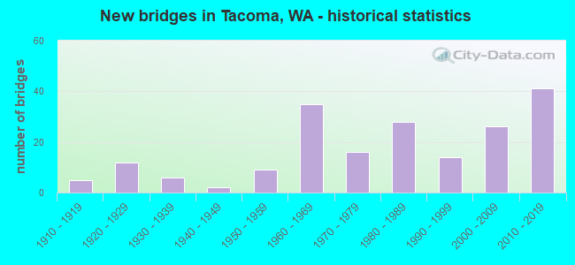
- New bridges - historical statistics
- 51910-1919
- 121920-1929
- 61930-1939
- 21940-1949
- 91950-1959
- 351960-1969
- 161970-1979
- 281980-1989
- 141990-1999
- 262000-2009
- 412010-2019
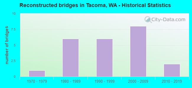
- Reconstructed bridges - Historical Statistics
- 11970-1979
- 61980-1989
- 61990-1999
- 82000-2009
- 22010-2019
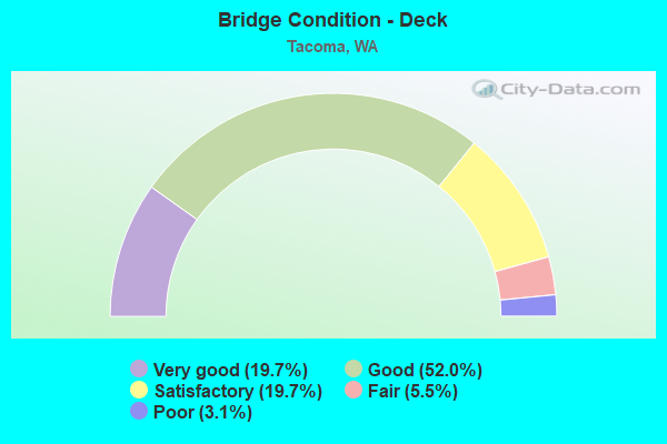
- Bridge Condition - Deck
- 19.7%Very good
- 52.0%Good
- 19.7%Satisfactory
- 5.5%Fair
- 3.1%Poor
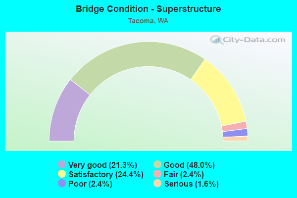
- Bridge Condition - Superstructure
- 21.3%Very good
- 48.0%Good
- 24.4%Satisfactory
- 2.4%Fair
- 2.4%Poor
- 1.6%Serious
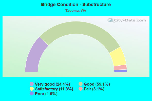
- Bridge Condition - Substructure
- 24.4%Very good
- 59.1%Good
- 11.8%Satisfactory
- 3.1%Fair
- 1.6%Poor
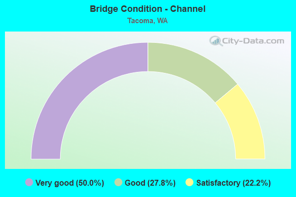
- Bridge Condition - Channel
- 50.0%Very good
- 27.8%Good
- 22.2%Satisfactory
Find on map >> Show street view
Structure Number: 1784A, Location: 0.7 N JCT I-5 (Lat: 47.237264, Lng: -122.396456), Route carried "on" structure: State highway 167, Year Built: 1934, Status: Open, Structure Length: 6.43m (21.10ft), Average Daily Traffic: 29,531 (year 2019), Truck Traffic: 6%, Average Future Daily Traffic: 42,760 (year 2039), Design Load: H 15, Features Intersected: BNSF RR
Minimum Vertical Clearance: 30+ m (98+ ft), Kilometerpoint: 1.030, Lanes on structure: 4, Base Highway Network: Yes, Owner: State Highway Agency, Approaching Roadway Width: 17.1m (56.1ft), Skew: 4 degrees, Material/Design: Concrete continuous, Design/Construction: Tee Beam, Number Of Spans In Main Unit: 5, Length of Maximum Span: 14.3m (46.9ft), Curb or Sidewalk Widths: Left: 1.2m (3.9ft), Right: 1.2m (3.9ft), Curb-To-Curb Width: 14.6m (47.9ft), Out-to-Out Width: 17.7m (58.1ft)
Condition: Deck: Fair, Superstructure: Poor, Substructure: Poor, Operating Rating: 25.9 metric tons, Method Used To Determine Operating Rating: Load and Resistance Factor Rating (LRFR) rating reported by rating factor(RF) method using HL-93 loadings, Inventory Rating: 19.8 metric tons, Method Used To Determine Inventory Rating: Load and Resistance Factor Rating (LRFR) rating reported by rating factor(RF) method using HL-93 loadings, Structural Evaluation: Meets minimum limits, Deck Geometry: High priority of replacement, Underclear: Somewhat better than minimum adequacy, Approach Roadway Alignment: Equal to present desirable criteria, Length Of Structure Improvement: 6.43m (21.10ft), Designated Inspection Frequency: Every 24 months, Inspection Date: October 2020, Bridge Improvement Cost: $2,448,000, Roadway Improvement Cost: $490,000, Total Project Cost: $4,895,000 ( Estimate for 2014), Deck Structure Type: Concrete Cast-file-Place, Wearing Surface/Protective System: Wearing Surface: Bituminous, Membrane: Preformed Fabric
Find on map >> Show street view
Structure Number: 2376A, Location: 4.2 N JCT I-5 (Lat: 47.277572, Lng: -122.394511), Route carried "on" structure: City street 50950, Year Built: 1939, Year Reconstructed: 2012, Status: Posted for load, Structure Length: 28.86m (94.69ft), Average Daily Traffic: 1,000 (year 2017), Truck Traffic: 5%, Average Future Daily Traffic: 2,000 (year 2037), Design Load: H 15, Features Intersected: HYLEBOS WATERWAY, Facility Carried by Structure: East 11th Street
Minimum Vertical Clearance: 30+ m (98+ ft), Kilometerpoint: 0.001, Lanes on structure: 2, Base Highway Network: Yes, Owner: City or Municipal Highway Agency, Approaching Roadway Width: 7.0m (23.0ft), Navigation Control: Yes ( Vertical Clearance: 6.4m (21.0ft), Horizontal Clearance: 45.7m (149.9ft)), Material/Design: Steel, Design/Construction: Movable - Bascule, Number Of Spans In Main Unit: 1, Number Of Approach Spans: 5, Length of Maximum Span: 66.1m (216.9ft), Curb or Sidewalk Widths: Left: 1.1m (3.6ft), Right: 1.1m (3.6ft), Curb-To-Curb Width: 7.3m (24.0ft), Out-to-Out Width: 7.9m (25.9ft)
Condition: Deck: Good, Superstructure: Satisfactory, Substructure: Good, Channel: Good, Operating Rating: 20.7 metric tons, Method Used To Determine Operating Rating: Load and Resistance Factor Rating (LRFR) rating reported by rating factor(RF) method using HL-93 loadings, Inventory Rating: 16.2 metric tons, Method Used To Determine Inventory Rating: Load and Resistance Factor Rating (LRFR) rating reported by rating factor(RF) method using HL-93 loadings, Structural Evaluation: Meets minimum limits, Deck Geometry: Meets minimum limits, Waterway Adequacy: Equal to present desirable criteria, Approach Roadway Alignment: Equal to present desirable criteria, Bridge Posting: Required (Relationship of Operating Rating to Maximum Legal Load: 0.1 - 9.9% below), Length Of Structure Improvement: 28.86m (94.69ft), Designated Inspection Frequency: Every 24 months, Critical Feature Inspection Frequency: Every 24 months, Underwater Inspection Frequency: Every 60 months, Other Special Inspection Frequency: Every 24 months, Inspection Date: September 2020, Critical Feature Inspection Date: September 2020, Underwater Inspection Date: October 2017, Other Special Inspection Date: September 2020, Bridge Improvement Cost: $4,735,000, Roadway Improvement Cost: $947,000, Total Project Cost: $9,470,000 ( Estimate for 2014), Deck Structure Type: Concrete Cast-file-Place, Wearing Surface/Protective System: Wearing Surface: Other
Find on map >> Show street view
Structure Number: 3418A, Location: 5.1 N JCT I-5 (Lat: 47.264722, Lng: -122.546028), Route carried "on" structure: State highway 16, Year Built: 1949, Status: Open, Structure Length: 182.21m (597.80ft), Average Daily Traffic: 43,392 (year 2019), Truck Traffic: 5%, Average Future Daily Traffic: 62,831 (year 2039), Features Intersected: TACOMA NARROWS
Minimum Vertical Clearance: 24.99m (81.99ft), Kilometerpoint: 11.716, Lanes on structure: 4, Base Highway Network: Yes, Owner: State Highway Agency, Approaching Roadway Width: 12.2m (40.0ft), Navigation Control: Yes ( Vertical Clearance: 60.4m (198.2ft), Horizontal Clearance: 783.3m (2,569.9ft)), Material/Design: Steel continuous, Design/Construction: Suspension, Number Of Spans In Main Unit: 3, Number Of Approach Spans: 10, Length of Maximum Span: 853.4m (2,799.9ft), Curb or Sidewalk Widths: Left: 0.9m (3.0ft), Right: 0.9m (3.0ft), Curb-To-Curb Width: 14.1m (46.3ft), Out-to-Out Width: 16.4m (53.8ft)
Condition: Deck: Satisfactory, Superstructure: Fair, Substructure: Satisfactory, Channel: Very good, Operating Rating: 20.4 metric tons, Method Used To Determine Operating Rating: Load and Resistance Factor Rating (LRFR) rating reported by rating factor(RF) method using HL-93 loadings, Inventory Rating: 15.6 metric tons, Method Used To Determine Inventory Rating: Load and Resistance Factor Rating (LRFR) rating reported by rating factor(RF) method using HL-93 loadings, Structural Evaluation: High priority of corrective action, Deck Geometry: High priority of replacement, Underclear: Equal to present desirable criteria, Waterway Adequacy: Equal to present desirable criteria, Approach Roadway Alignment: Equal to present desirable criteria, Length Of Structure Improvement: 182.21m (597.80ft), Designated Inspection Frequency: Every 24 months, Critical Feature Inspection Frequency: Every 24 months, Underwater Inspection Frequency: Every 60 months, Other Special Inspection Frequency: Every 24 months, Inspection Date: July 2021, Critical Feature Inspection Date: July 2021, Underwater Inspection Date: Febuary 2018, Other Special Inspection Date: July 2021, Bridge Improvement Cost: $50,215,000, Roadway Improvement Cost: $10,043,000, Total Project Cost: $100,430,000 ( Estimate for 2014), Deck Structure Type: Concrete Cast-file-Place, Wearing Surface/Protective System: Wearing Surface: Bituminous
Find on map >> Show street view
Structure Number: 5452A, Location: E 11TH ST JCT I-705 (Lat: 47.253956, Lng: -122.433075), Route carried "on" structure: City street 3292, Year Built: 1911, Year Reconstructed: 2013, Status: Open, Structure Length: 53.28m (174.80ft), Average Daily Traffic: 3,100 (year 2021), Truck Traffic: 5%, Average Future Daily Traffic: 3,200 (year 2043), Design Load: H 15, Features Intersected: CITY WATERWAY CS2749, Facility Carried by Structure: E 11TH ST
Minimum Vertical Clearance: 5.41m (17.75ft), Kilometerpoint: 0.001, Lanes on structure: 2, Lanes under structure: 10, Base Highway Network: Yes, Owner: City or Municipal Highway Agency, Approaching Roadway Width: 15.2m (49.9ft), Navigation Control: Yes ( Vertical Clearance: 42.4m (139.1ft), Horizontal Clearance: 61.0m (200.1ft)), Material/Design: Steel, Design/Construction: Movable - Lift, Number Of Spans In Main Unit: 1, Number Of Approach Spans: 20, Length of Maximum Span: 67.4m (221.1ft), Curb or Sidewalk Widths: Left: 2.2m (7.2ft), Right: 2.2m (7.2ft), Curb-To-Curb Width: 10.4m (34.1ft), Out-to-Out Width: 15.6m (51.2ft)
Condition: Deck: Good, Superstructure: Satisfactory, Substructure: Satisfactory, Channel: Satisfactory, Operating Rating: 30.1 metric tons, Method Used To Determine Operating Rating: Load and Resistance Factor Rating (LRFR) rating reported by rating factor(RF) method using HL-93 loadings, Inventory Rating: 23.7 metric tons, Method Used To Determine Inventory Rating: Load and Resistance Factor Rating (LRFR) rating reported by rating factor(RF) method using HL-93 loadings, Structural Evaluation: Equal to present minimum criteria, Deck Geometry: Somewhat better than minimum adequacy, Underclear: High priority of corrective action, Waterway Adequacy: Equal to present desirable criteria, Approach Roadway Alignment: Equal to present desirable criteria, Length Of Structure Improvement: 36.03m (118.21ft), Designated Inspection Frequency: Every 24 months, Critical Feature Inspection Frequency: Every 24 months, Underwater Inspection Frequency: Every 60 months, Other Special Inspection Frequency: Every 24 months, Inspection Date: Febuary 2021, Critical Feature Inspection Date: Febuary 2021, Underwater Inspection Date: Febuary 2018, Other Special Inspection Date: Febuary 2021, Bridge Improvement Cost: $20,000,000, Total Project Cost: $20,000,000, Deck Structure Type: Concrete Cast-file-Place, Wearing Surface/Protective System: Wearing Surface: Monolithic Concrete, Deck Protection: Epoxy Coated Reinforcing
Find on map >> Show street view
Structure Number: 5667C, Location: 1.4 N JCT SR 512 (Lat: 47.181067, Lng: -122.465219), Route carried "on" structure: City street , Year Built: 1958, Status: Open, Structure Length: 4.30m (14.11ft), Average Daily Traffic: 21,134 (year 2019), Truck Traffic: 2%, Average Future Daily Traffic: 30,602 (year 2039), Design Load: HS 20, Features Intersected: I-5, Facility Carried by Structure: S 84TH ST
Minimum Vertical Clearance: 30+ m (98+ ft), Kilometerpoint: 0.113, Lanes on structure: 4, Lanes under structure: 8, Owner: State Highway Agency, Approaching Roadway Width: 19.5m (64.0ft), Material/Design: Concrete continuous, Design/Construction: Slab, Number Of Spans In Main Unit: 2, Length of Maximum Span: 21.0m (68.9ft), Curb or Sidewalk Widths: Left: 1.2m (3.9ft), Right: 2.3m (7.5ft), Curb-To-Curb Width: 16.0m (52.5ft), Out-to-Out Width: 19.5m (64.0ft)
Condition: Deck: Satisfactory, Superstructure: Fair, Substructure: Satisfactory, Operating Rating: 63.5 metric tons, Method Used To Determine Operating Rating: Load Factor (LF), Inventory Rating: 37.2 metric tons, Method Used To Determine Inventory Rating: Load Factor (LF), Structural Evaluation: Somewhat better than minimum adequacy, Deck Geometry: Meets minimum limits, Underclear: Meets minimum limits, Approach Roadway Alignment: Equal to present desirable criteria, Length Of Structure Improvement: 4.30m (14.11ft), Designated Inspection Frequency: Every 24 months, Inspection Date: March 2020, Bridge Improvement Cost: $1,861,000, Roadway Improvement Cost: $372,000, Total Project Cost: $3,722,000 ( Estimate for 2014), Deck Structure Type: Concrete Cast-file-Place, Wearing Surface/Protective System: Wearing Surface: Monolithic Concrete
Find on map >> Show street view
Structure Number: 5723A, Location: 2.1 N JCT SR 512 (Lat: 47.190608, Lng: -122.462736), Route carried "on" structure: City street , Year Built: 1958, Year Reconstructed: 1988, Status: Open, Structure Length: 5.58m (18.31ft), Average Daily Traffic: 31,732 (year 2007), Truck Traffic: 2%, Average Future Daily Traffic: 56,578 (year 2036), Design Load: HS 20, Features Intersected: I-5, Facility Carried by Structure: S 74TH - S 72ND ST
Minimum Vertical Clearance: 30+ m (98+ ft), Kilometerpoint: 0.145, Lanes on structure: 8, Lanes under structure: 8, Base Highway Network: Yes, Owner: State Highway Agency, Approaching Roadway Width: 26.8m (87.9ft), Skew: 3 degrees, Material/Design: Concrete continuous, Design/Construction: Box Beam or Girders - Multiple, Number Of Spans In Main Unit: 2, Length of Maximum Span: 27.1m (88.9ft), Curb or Sidewalk Widths: Left: 1.8m (5.9ft), Right: 1.8m (5.9ft), Curb-To-Curb Width: 26.8m (87.9ft), Out-to-Out Width: 31.1m (102.0ft)
Condition: Deck: Good, Superstructure: Satisfactory, Substructure: Good, Operating Rating: 73.5 metric tons, Method Used To Determine Operating Rating: Load Factor (LF), Inventory Rating: 43.5 metric tons, Method Used To Determine Inventory Rating: Load Factor (LF), Structural Evaluation: Equal to present minimum criteria, Deck Geometry: High priority of replacement, Underclear: High priority of corrective action, Approach Roadway Alignment: Equal to present desirable criteria, Length Of Structure Improvement: 5.58m (18.31ft), Designated Inspection Frequency: Every 24 months, Inspection Date: November 2021, Bridge Improvement Cost: $3,294,000, Roadway Improvement Cost: $659,000, Total Project Cost: $6,588,000 ( Estimate for 2014), Deck Structure Type: Concrete Cast-file-Place, Wearing Surface/Protective System: Wearing Surface: Latex Concrete, Deck Protection: Epoxy Coated Reinforcing
Find on map >> Show street view
Structure Number: 5831A, Location: 3.2 N JCT SR 512 (Lat: 47.206583, Lng: -122.462056), Route carried "on" structure: City street , Year Built: 1958, Status: Open, Structure Length: 6.34m (20.80ft), Average Daily Traffic: 29,346 (year 2019), Truck Traffic: 2%, Average Future Daily Traffic: 42,493 (year 2039), Design Load: HS 20, Features Intersected: I-5, Facility Carried by Structure: S 56TH ST
Minimum Vertical Clearance: 30+ m (98+ ft), Kilometerpoint: 0.241, Lanes on structure: 6, Lanes under structure: 10, Base Highway Network: Yes, Owner: State Highway Agency, Approaching Roadway Width: 24.4m (80.1ft), Material/Design: Concrete continuous, Design/Construction: Slab, Number Of Spans In Main Unit: 4, Length of Maximum Span: 17.4m (57.1ft), Curb or Sidewalk Widths: Left: 1.4m (4.6ft), Right: 1.4m (4.6ft), Curb-To-Curb Width: 24.4m (80.1ft), Out-to-Out Width: 28.0m (91.9ft)
Condition: Deck: Satisfactory, Superstructure: Satisfactory, Substructure: Good, Operating Rating: 27.2 metric tons, Method Used To Determine Operating Rating: Load and Resistance Factor Rating (LRFR) rating reported by rating factor(RF) method using HL-93 loadings, Inventory Rating: 21.1 metric tons, Method Used To Determine Inventory Rating: Load and Resistance Factor Rating (LRFR) rating reported by rating factor(RF) method using HL-93 loadings, Structural Evaluation: Somewhat better than minimum adequacy, Deck Geometry: Somewhat better than minimum adequacy, Underclear: High priority of corrective action, Approach Roadway Alignment: Equal to present desirable criteria, Length Of Structure Improvement: 6.34m (20.80ft), Designated Inspection Frequency: Every 24 months, Inspection Date: November 2021, Bridge Improvement Cost: $3,411,000, Roadway Improvement Cost: $682,000, Total Project Cost: $6,822,000 ( Estimate for 2014), Deck Structure Type: Concrete Cast-file-Place, Wearing Surface/Protective System: Wearing Surface: Latex Concrete
Find on map >> Show street view
Structure Number: 6069A, Location: 2.5 N JCT I-5 (Lat: 47.260556, Lng: -122.419722), Route carried "on" structure: City street 50950, Year Built: 1911, Status: Closed, Structure Length: 17.43m (57.19ft), Average Daily Traffic: 2,400 (year 2019), Average Future Daily Traffic: 2,400 (year 2041), Features Intersected: PUYALLUP WATERWAY RR, Facility Carried by Structure: STATE ROUTE 509
Minimum Vertical Clearance: 5.11m (16.77ft), Kilometerpoint: 0.001, Lanes on structure: 2, Owner: City or Municipal Highway Agency, Approaching Roadway Width: 19.5m (64.0ft), Material/Design: Steel, Design/Construction: Truss - Thru, Number Of Spans In Main Unit: 3, Number Of Approach Spans: 6, Length of Maximum Span: 49.1m (161.1ft), Curb or Sidewalk Widths: Left: 1.8m (5.9ft), Right: 1.8m (5.9ft), Curb-To-Curb Width: 7.3m (24.0ft), Out-to-Out Width: 12.8m (42.0ft)
Condition: Deck: Poor, Superstructure: Serious, Substructure: Poor, Channel: Satisfactory, Waterway Adequacy: Equal to present desirable criteria, Approach Roadway Alignment: Equal to present desirable criteria, Bridge Posting: Required (Relationship of Operating Rating to Maximum Legal Load: 20.0 - 29.9% below), Length Of Structure Improvement: 17.74m (58.20ft), Designated Inspection Frequency: Every 24 months, Critical Feature Inspection Frequency: Every 24 months, Underwater Inspection Frequency: Every 24 months, Inspection Date: December 2019, Critical Feature Inspection Date: December 2019, Underwater Inspection Date: September 2020, Bridge Improvement Cost: $8,846,000, Roadway Improvement Cost: $1,769,000, Total Project Cost: $17,693,000 ( Estimate for 2014), Deck Structure Type: Open Grating
Find on map >> Show street view
Structure Number: 6088B, Location: 0.5 N JCT SR 16 (Lat: 47.230311, Lng: -122.450575), Route carried "on" structure: Interstate 5, Year Built: 1959, Year Reconstructed: 1989, Status: Open, Structure Length: 7.07m (23.20ft), Average Daily Traffic: 135,007 (year 2019), Truck Traffic: 11%, Average Future Daily Traffic: 195,490 (year 2039), Design Load: HS 20+Mod, Features Intersected: S M ST
Minimum Vertical Clearance: 30+ m (98+ ft), Kilometerpoint: 213.785, Lanes on structure: 9, Lanes under structure: 5, Base Highway Network: Yes, Owner: State Highway Agency, Approaching Roadway Width: 39.6m (129.9ft), Skew: 30 degrees, Material/Design: Concrete continuous, Design/Construction: Box Beam or Girders - Multiple, Number Of Spans In Main Unit: 3, Number Of Approach Spans: 2, Length of Maximum Span: 25.0m (82.0ft), Curb-To-Curb Width: 39.6m (129.9ft), Out-to-Out Width: 53.8m (176.5ft)
Condition: Deck: Good, Superstructure: Good, Substructure: Good, Operating Rating: 49.9 metric tons, Method Used To Determine Operating Rating: Load Factor (LF), Inventory Rating: 29.9 metric tons, Method Used To Determine Inventory Rating: Load Factor (LF), Structural Evaluation: Better than present minimum criteria, Deck Geometry: Better than present minimum criteria, Underclear: Somewhat better than minimum adequacy, Approach Roadway Alignment: Equal to present desirable criteria, Length Of Structure Improvement: 7.07m (23.20ft), Designated Inspection Frequency: Every 24 months, Inspection Date: December 2020, Bridge Improvement Cost: $6,125,000, Roadway Improvement Cost: $1,225,000, Total Project Cost: $12,250,000 ( Estimate for 2014), Deck Structure Type: Concrete Cast-file-Place, Wearing Surface/Protective System: Wearing Surface: Latex Concrete
Find on map >> Show street view
Structure Number: 6613B, Location: 0.2 N JCT SR 167 (Lat: 47.239972, Lng: -122.402917), Route carried "on" structure: Interstate 5, Year Built: 1962, Status: Open, Structure Length: 44.35m (145.51ft), Average Daily Traffic: 91,931 (year 2019), Truck Traffic: 8%, Average Future Daily Traffic: 133,116 (year 2039), Design Load: HS 20, Features Intersected: PUYALLUP R/RR/SR 167
Minimum Vertical Clearance: 30+ m (98+ ft), Kilometerpoint: 217.648, Lanes on structure: 5, Lanes under structure: 4, Base Highway Network: Yes, Owner: State Highway Agency, Approaching Roadway Width: 20.7m (67.9ft), Skew: 9 degrees, Navigation Control: Yes ( Vertical Clearance: 11.9m (39.0ft), Horizontal Clearance: 22.9m (75.1ft)), Material/Design: Prestressed concrete, Design/Construction: Stringer/Multi-beam, Number Of Spans In Main Unit: 16, Length of Maximum Span: 30.8m (101.0ft), Curb-To-Curb Width: 17.4m (57.1ft), Out-to-Out Width: 19.1m (62.7ft)
Condition: Deck: Good, Superstructure: Satisfactory, Substructure: Satisfactory, Channel: Good, Operating Rating: 68.9 metric tons, Method Used To Determine Operating Rating: Load Factor (LF), Inventory Rating: 40.8 metric tons, Method Used To Determine Inventory Rating: Load Factor (LF), Structural Evaluation: Equal to present minimum criteria, Deck Geometry: High priority of replacement, Underclear: Equal to present minimum criteria, Waterway Adequacy: Equal to present desirable criteria, Approach Roadway Alignment: Equal to present desirable criteria, Length Of Structure Improvement: 44.35m (145.51ft), Designated Inspection Frequency: Every 48 months, Underwater Inspection Frequency: Every 60 months, Inspection Date: June 2018, Underwater Inspection Date: September 2019, Bridge Improvement Cost: $20,370,000, Roadway Improvement Cost: $4,074,000, Total Project Cost: $40,740,000 ( Estimate for 2014), Deck Structure Type: Concrete Cast-file-Place, Wearing Surface/Protective System: Wearing Surface: Monolithic Concrete
Find on map >> Show street view
Structure Number: 6792A, Location: 1.1 N JCT SR 7 (Lat: 47.238972, Lng: -122.410972), Route carried "on" structure: Interstate 5, Year Built: 1962, Year Reconstructed: 2012, Status: Open, Structure Length: 6.58m (21.59ft), Average Daily Traffic: 107,147 (year 2019), Truck Traffic: 8%, Average Future Daily Traffic: 155,148 (year 2039), Design Load: HS 20, Features Intersected: PORTLAND AVE
Minimum Vertical Clearance: 30+ m (98+ ft), Kilometerpoint: 217.052, Lanes on structure: 6, Lanes under structure: 6, Base Highway Network: Yes, Owner: State Highway Agency, Approaching Roadway Width: 28.3m (92.8ft), Material/Design: Prestressed concrete, Design/Construction: Stringer/Multi-beam, Number Of Spans In Main Unit: 3, Length of Maximum Span: 28.0m (91.9ft), Curb-To-Curb Width: 28.1m (92.2ft), Out-to-Out Width: 29.1m (95.5ft)
Condition: Deck: Satisfactory, Superstructure: Satisfactory, Substructure: Good, Operating Rating: 63.5 metric tons, Method Used To Determine Operating Rating: Load Factor (LF), Inventory Rating: 38.1 metric tons, Method Used To Determine Inventory Rating: Load Factor (LF), Structural Evaluation: Equal to present minimum criteria, Deck Geometry: Equal to present minimum criteria, Underclear: Meets minimum limits, Approach Roadway Alignment: Equal to present desirable criteria, Length Of Structure Improvement: 6.58m (21.59ft), Designated Inspection Frequency: Every 24 months, Inspection Date: December 2020, Bridge Improvement Cost: $4,104,000, Roadway Improvement Cost: $821,000, Total Project Cost: $8,208,000 ( Estimate for 2014), Deck Structure Type: Concrete Cast-file-Place, Wearing Surface/Protective System: Wearing Surface: Monolithic Concrete
Find on map >> Show street view
Structure Number: 6792B, Location: 1.1 N JCT SR 7 (Lat: 47.239222, Lng: -122.411028), Route carried "on" structure: Interstate 5, Year Built: 1962, Year Reconstructed: 2010, Status: Open, Structure Length: 6.58m (21.59ft), Average Daily Traffic: 107,147 (year 2019), Truck Traffic: 8%, Average Future Daily Traffic: 155,148 (year 2039), Design Load: HS 20, Features Intersected: PORTLAND AVE
Minimum Vertical Clearance: 30+ m (98+ ft), Kilometerpoint: 217.052, Lanes on structure: 7, Lanes under structure: 6, Base Highway Network: Yes, Owner: State Highway Agency, Approaching Roadway Width: 29.9m (98.1ft), Material/Design: Prestressed concrete, Design/Construction: Stringer/Multi-beam, Number Of Spans In Main Unit: 3, Length of Maximum Span: 28.0m (91.9ft), Curb-To-Curb Width: 29.7m (97.4ft), Out-to-Out Width: 31.2m (102.4ft)
Condition: Deck: Satisfactory, Superstructure: Good, Substructure: Good, Operating Rating: 64.4 metric tons, Method Used To Determine Operating Rating: Load Factor (LF), Inventory Rating: 38.1 metric tons, Method Used To Determine Inventory Rating: Load Factor (LF), Structural Evaluation: Better than present minimum criteria, Deck Geometry: Meets minimum limits, Underclear: Meets minimum limits, Approach Roadway Alignment: Equal to present desirable criteria, Length Of Structure Improvement: 6.58m (21.59ft), Designated Inspection Frequency: Every 24 months, Inspection Date: December 2020, Bridge Improvement Cost: $4,320,000, Roadway Improvement Cost: $864,000, Total Project Cost: $8,640,000 ( Estimate for 2014), Deck Structure Type: Concrete Cast-file-Place, Wearing Surface/Protective System: Wearing Surface: Latex Concrete
Find on map >> Show street view
Structure Number: 6821A, Location: 1.2 N JCT SR 7 (Lat: 47.239556, Lng: -122.407694), Route carried "on" structure: Interstate 5, Year Built: 1962, Year Reconstructed: 2012, Status: Open, Structure Length: 3.69m (12.11ft), Average Daily Traffic: 183,861 (year 2019), Truck Traffic: 8%, Average Future Daily Traffic: 266,230 (year 2039), Design Load: HS 20, Features Intersected: SR 167 NB
Minimum Vertical Clearance: 30+ m (98+ ft), Kilometerpoint: 217.310, Lanes on structure: 11, Lanes under structure: 2, Base Highway Network: Yes, Owner: State Highway Agency, Approaching Roadway Width: 59.7m (195.9ft), Skew: 31 degrees, Material/Design: Prestressed concrete, Design/Construction: Stringer/Multi-beam, Number Of Spans In Main Unit: 3, Length of Maximum Span: 14.9m (48.9ft), Curb-To-Curb Width: 59.7m (195.9ft), Out-to-Out Width: 60.7m (199.1ft)
Condition: Deck: Satisfactory, Superstructure: Satisfactory, Substructure: Good, Operating Rating: 24.9 metric tons, Method Used To Determine Operating Rating: Load and Resistance Factor Rating (LRFR) rating reported by rating factor(RF) method using HL-93 loadings, Inventory Rating: 19.4 metric tons, Method Used To Determine Inventory Rating: Load and Resistance Factor Rating (LRFR) rating reported by rating factor(RF) method using HL-93 loadings, Structural Evaluation: Meets minimum limits, Deck Geometry: Superior to present desirable criteria, Underclear: Equal to present minimum criteria, Approach Roadway Alignment: Equal to present desirable criteria, Length Of Structure Improvement: 3.69m (12.11ft), Designated Inspection Frequency: Every 24 months, Inspection Date: December 2020, Bridge Improvement Cost: $4,792,000, Roadway Improvement Cost: $958,000, Total Project Cost: $9,583,000 ( Estimate for 2014), Deck Structure Type: Concrete Cast-file-Place, Wearing Surface/Protective System: Wearing Surface: Latex Concrete
Find on map >> Show street view
Structure Number: 6979B, Location: 0.2 N JCT SR 167 (Lat: 47.239417, Lng: -122.404778), Route carried "on" structure: Interstate 5, Year Built: 1963, Year Reconstructed: 1970, Status: Open, Structure Length: 4.57m (14.99ft), Average Daily Traffic: 183,861 (year 2019), Truck Traffic: 8%, Average Future Daily Traffic: 266,230 (year 2039), Design Load: HS 20, Features Intersected: EAST T ST SEWER
Minimum Vertical Clearance: 30+ m (98+ ft), Kilometerpoint: 217.535, Lanes on structure: 4, Base Highway Network: Yes, Owner: State Highway Agency, Approaching Roadway Width: 18.9m (62.0ft), Skew: 30 degrees, Material/Design: Prestressed concrete, Design/Construction: Stringer/Multi-beam, Number Of Spans In Main Unit: 3, Length of Maximum Span: 14.3m (46.9ft), Curb or Sidewalk Widths: Left: 0.3m (1.0ft), Right: 0.0m, Curb-To-Curb Width: 18.3m (60.0ft), Out-to-Out Width: 20.1m (65.9ft)
Condition: Deck: Satisfactory, Superstructure: Good, Substructure: Good, Operating Rating: 66.2 metric tons, Method Used To Determine Operating Rating: Load Factor (LF), Inventory Rating: 39.0 metric tons, Method Used To Determine Inventory Rating: Load Factor (LF), Structural Evaluation: Better than present minimum criteria, Deck Geometry: Meets minimum limits, Approach Roadway Alignment: Equal to present desirable criteria, Length Of Structure Improvement: 4.57m (14.99ft), Designated Inspection Frequency: Every 24 months, Inspection Date: December 2020, Bridge Improvement Cost: $1,920,000, Roadway Improvement Cost: $384,000, Total Project Cost: $3,840,000 ( Estimate for 2014), Deck Structure Type: Concrete Cast-file-Place, Wearing Surface/Protective System: Wearing Surface: Latex Concrete
Find on map >> Show street view
Structure Number: 6979E, Location: 0.2 N JCT SR 167 (Lat: 47.239992, Lng: -122.404186), Route carried "on" structure: Ramp Interstate 5, Year Built: 1963, Status: Open, Structure Length: 5.61m (18.41ft), Average Daily Traffic: 10,583 (year 2012), Truck Traffic: 5%, Average Future Daily Traffic: 18,203 (year 2036), Design Load: HS 20, Features Intersected: SR 167 RAMP TO SB I-5, Facility Carried by Structure: SB RAMP TO SR 167
Minimum Vertical Clearance: 30+ m (98+ ft), Kilometerpoint: 0.193, Lanes on structure: 1, Lanes under structure: 1, Owner: State Highway Agency, Approaching Roadway Width: 7.3m (24.0ft), Material/Design: Concrete continuous, Design/Construction: Box Beam or Girders - Multiple, Number Of Spans In Main Unit: 3, Length of Maximum Span: 21.9m (71.9ft), Curb or Sidewalk Widths: Left: 0.5m (1.6ft), Right: 0.5m (1.6ft), Curb-To-Curb Width: 6.1m (20.0ft), Out-to-Out Width: 7.5m (24.6ft)
Condition: Deck: Satisfactory, Superstructure: Good, Substructure: Good, Operating Rating: 67.1 metric tons, Method Used To Determine Operating Rating: Load Factor (LF), Inventory Rating: 39.9 metric tons, Method Used To Determine Inventory Rating: Load Factor (LF), Structural Evaluation: Better than present minimum criteria, Deck Geometry: Somewhat better than minimum adequacy, Underclear: Better than present minimum criteria, Approach Roadway Alignment: Equal to present desirable criteria, Length Of Structure Improvement: 5.61m (18.41ft), Designated Inspection Frequency: Every 24 months, Inspection Date: December 2020, Bridge Improvement Cost: $957,000, Roadway Improvement Cost: $191,000, Total Project Cost: $1,914,000 ( Estimate for 2014), Deck Structure Type: Concrete Cast-file-Place, Wearing Surface/Protective System: Wearing Surface: Monolithic Concrete
Find on map >> Show street view
Structure Number: 6979G, Location: 0.2 E JCT I-5 (Lat: 47.240083, Lng: -122.404389), Route carried "on" structure: Ramp State highway 167, Year Built: 1963, Status: Open, Structure Length: 2.62m (8.60ft), Average Daily Traffic: 12,184 (year 2012), Truck Traffic: 5%, Average Future Daily Traffic: 20,956 (year 2036), Design Load: HS 20+Mod, Features Intersected: DRAINAGE
Minimum Vertical Clearance: 5.11m (16.77ft), Kilometerpoint: 0.161, Lanes on structure: 1, Owner: State Highway Agency, Approaching Roadway Width: 6.1m (20.0ft), Skew: 1 degrees, Material/Design: Concrete continuous, Design/Construction: Slab, Number Of Spans In Main Unit: 4, Length of Maximum Span: 6.7m (22.0ft), Curb-To-Curb Width: 6.7m (22.0ft), Out-to-Out Width: 7.6m (24.9ft)
Condition: Deck: Good, Superstructure: Satisfactory, Substructure: Good, Operating Rating: 35.6 metric tons, Method Used To Determine Operating Rating: Load and Resistance Factor Rating (LRFR) rating reported by rating factor(RF) method using HL-93 loadings, Inventory Rating: 27.5 metric tons, Method Used To Determine Inventory Rating: Load and Resistance Factor Rating (LRFR) rating reported by rating factor(RF) method using HL-93 loadings, Structural Evaluation: Equal to present minimum criteria, Deck Geometry: Equal to present minimum criteria, Approach Roadway Alignment: High priority of corrective action, Length Of Structure Improvement: 2.62m (8.60ft), Designated Inspection Frequency: Every 24 months, Inspection Date: December 2020, Bridge Improvement Cost: $378,000, Roadway Improvement Cost: $76,000, Total Project Cost: $757,000 ( Estimate for 2014), Deck Structure Type: Concrete Cast-file-Place, Wearing Surface/Protective System: Wearing Surface: Epoxy Overlay
Find on map >> Show street view
Structure Number: 7326A, Location: 1.5 N JCT SR 16 (Lat: 47.233139, Lng: -122.433778), Route carried "on" structure: Interstate 5, Year Built: 1964, Status: Open, Structure Length: 24.90m (81.69ft), Average Daily Traffic: 85,803 (year 2019), Truck Traffic: 8%, Average Future Daily Traffic: 124,242 (year 2039), Design Load: HS 20, Features Intersected: I-705, SR 7, RAMPS, RR
Minimum Vertical Clearance: 30+ m (98+ ft), Kilometerpoint: 215.185, Lanes on structure: 2, Lanes under structure: 8, Base Highway Network: Yes, Owner: State Highway Agency, Approaching Roadway Width: 13.7m (44.9ft), Material/Design: Concrete continuous, Design/Construction: Box Beam or Girders - Multiple, Number Of Spans In Main Unit: 10, Length of Maximum Span: 30.5m (100.1ft), Curb-To-Curb Width: 13.7m (44.9ft), Out-to-Out Width: 15.5m (50.9ft)
Condition: Deck: Satisfactory, Superstructure: Good, Substructure: Good, Operating Rating: 59.0 metric tons, Method Used To Determine Operating Rating: Load Factor (LF), Inventory Rating: 35.4 metric tons, Method Used To Determine Inventory Rating: Load Factor (LF), Structural Evaluation: Better than present minimum criteria, Deck Geometry: Superior to present desirable criteria, Underclear: Meets minimum limits, Approach Roadway Alignment: Equal to present desirable criteria, Length Of Structure Improvement: 24.90m (81.69ft), Designated Inspection Frequency: Every 48 months, Inspection Date: August 2018, Bridge Improvement Cost: $7,680,000, Roadway Improvement Cost: $1,536,000, Total Project Cost: $15,360,000 ( Estimate for 2014), Deck Structure Type: Concrete Cast-file-Place, Wearing Surface/Protective System: Wearing Surface: Latex Concrete
Find on map >> Show street view
Structure Number: 7326B, Location: 1.5 N JCT SR 16 (Lat: 47.233278, Lng: -122.434000), Route carried "on" structure: Interstate 5, Year Built: 1964, Year Reconstructed: 1989, Status: Open, Structure Length: 24.90m (81.69ft), Average Daily Traffic: 85,803 (year 2019), Truck Traffic: 8%, Average Future Daily Traffic: 124,242 (year 2039), Design Load: HS 20, Features Intersected: I-705, SR 7, RAMPS, RR
Minimum Vertical Clearance: 30+ m (98+ ft), Kilometerpoint: 215.169, Lanes on structure: 4, Lanes under structure: 8, Base Highway Network: Yes, Owner: State Highway Agency, Approaching Roadway Width: 18.9m (62.0ft), Material/Design: Concrete continuous, Design/Construction: Box Beam or Girders - Multiple, Number Of Spans In Main Unit: 10, Length of Maximum Span: 29.6m (97.1ft), Curb-To-Curb Width: 18.9m (62.0ft), Out-to-Out Width: 19.8m (65.0ft)
Condition: Deck: Good, Superstructure: Satisfactory, Substructure: Good, Operating Rating: 30.8 metric tons, Method Used To Determine Operating Rating: Load and Resistance Factor Rating (LRFR) rating reported by rating factor(RF) method using HL-93 loadings, Inventory Rating: 23.7 metric tons, Method Used To Determine Inventory Rating: Load and Resistance Factor Rating (LRFR) rating reported by rating factor(RF) method using HL-93 loadings, Structural Evaluation: Somewhat better than minimum adequacy, Deck Geometry: Meets minimum limits, Underclear: High priority of corrective action, Approach Roadway Alignment: Equal to present desirable criteria, Length Of Structure Improvement: 24.90m (81.69ft), Designated Inspection Frequency: Every 24 months, Inspection Date: November 2021, Bridge Improvement Cost: $10,458,000, Roadway Improvement Cost: $2,092,000, Total Project Cost: $20,915,000 ( Estimate for 2014), Deck Structure Type: Concrete Cast-file-Place, Wearing Surface/Protective System: Wearing Surface: Latex Concrete
Find on map >> Show street view
Structure Number: 7326C, Location: 1.4 N JCT SR 16 (Lat: 47.232778, Lng: -122.433139), Route carried "on" structure: Ramp Interstate 5, Year Built: 1964, Status: Open, Structure Length: 8.26m (27.10ft), Average Daily Traffic: 19,637 (year 2012), Truck Traffic: 5%, Average Future Daily Traffic: 33,776 (year 2036), Design Load: HS 20, Features Intersected: S-S RAMP I-705 TO SR 7
Minimum Vertical Clearance: 30+ m (98+ ft), Kilometerpoint: 0.177, Lanes on structure: 2, Lanes under structure: 4, Owner: State Highway Agency, Approaching Roadway Width: 10.4m (34.1ft), Material/Design: Concrete continuous, Design/Construction: Box Beam or Girders - Multiple, Number Of Spans In Main Unit: 4, Length of Maximum Span: 25.9m (85.0ft), Curb-To-Curb Width: 9.8m (32.2ft), Out-to-Out Width: 11.5m (37.7ft)
Condition: Deck: Good, Superstructure: Good, Substructure: Very good, Operating Rating: 81.6 metric tons, Method Used To Determine Operating Rating: Load Factor (LF), Inventory Rating: 48.1 metric tons, Method Used To Determine Inventory Rating: Load Factor (LF), Structural Evaluation: Better than present minimum criteria, Deck Geometry: Equal to present minimum criteria, Underclear: Superior to present desirable criteria, Approach Roadway Alignment: Equal to present minimum criteria, Length Of Structure Improvement: 8.26m (27.10ft), Designated Inspection Frequency: Every 48 months, Inspection Date: December 2018, Bridge Improvement Cost: $1,951,000, Roadway Improvement Cost: $390,000, Total Project Cost: $3,902,000 ( Estimate for 2014), Deck Structure Type: Concrete Cast-file-Place, Wearing Surface/Protective System: Wearing Surface: Monolithic Concrete
Find on map >> Show street view
Structure Number: 7326D, Location: 1.4 N JCT SR 16 (Lat: 47.233161, Lng: -122.431917), Route carried "on" structure: Ramp Interstate 5, Year Built: 1965, Status: Open, Structure Length: 8.08m (26.51ft), Average Daily Traffic: 4,393 (year 2012), Truck Traffic: 5%, Average Future Daily Traffic: 7,556 (year 2036), Design Load: HS 20, Features Intersected: S-S RAMP I-705 TO SR 7
Minimum Vertical Clearance: 30+ m (98+ ft), Kilometerpoint: 0.370, Lanes on structure: 1, Lanes under structure: 4, Owner: State Highway Agency, Approaching Roadway Width: 6.1m (20.0ft), Material/Design: Concrete continuous, Design/Construction: Box Beam or Girders - Multiple, Number Of Spans In Main Unit: 3, Length of Maximum Span: 32.0m (105.0ft), Curb-To-Curb Width: 6.4m (21.0ft), Out-to-Out Width: 8.1m (26.6ft)
Condition: Deck: Satisfactory, Superstructure: Satisfactory, Substructure: Good, Operating Rating: 72.6 metric tons, Method Used To Determine Operating Rating: Load Factor (LF), Inventory Rating: 42.6 metric tons, Method Used To Determine Inventory Rating: Load Factor (LF), Structural Evaluation: Equal to present minimum criteria, Deck Geometry: Somewhat better than minimum adequacy, Underclear: Superior to present desirable criteria, Approach Roadway Alignment: Equal to present desirable criteria, Length Of Structure Improvement: 8.08m (26.51ft), Designated Inspection Frequency: Every 24 months, Inspection Date: December 2020, Bridge Improvement Cost: $1,166,000, Roadway Improvement Cost: $233,000, Total Project Cost: $2,332,000 ( Estimate for 2014), Deck Structure Type: Concrete Cast-file-Place, Wearing Surface/Protective System: Wearing Surface: Monolithic Concrete
Find on map >> Show street view
Structure Number: 7326E, Location: 5.6 N JCT SR 512 (Lat: 47.232750, Lng: -122.433000), Route carried "on" structure: State highway 7, Year Built: 1965, Status: Open, Structure Length: 7.01m (23.00ft), Average Daily Traffic: 14,969 (year 2019), Truck Traffic: 4%, Average Future Daily Traffic: 21,675 (year 2039), Design Load: HS 20, Features Intersected: SR 7 SB
Minimum Vertical Clearance: 30+ m (98+ ft), Kilometerpoint: 94.227, Lanes on structure: 1, Lanes under structure: 4, Base Highway Network: Yes, Owner: State Highway Agency, Approaching Roadway Width: 11.0m (36.1ft), Material/Design: Concrete continuous, Design/Construction: Box Beam or Girders - Multiple, Number Of Spans In Main Unit: 3, Length of Maximum Span: 25.9m (85.0ft), Curb or Sidewalk Widths: Left: 0.5m (1.6ft), Right: 0.5m (1.6ft), Curb-To-Curb Width: 9.8m (32.2ft), Out-to-Out Width: 11.5m (37.7ft)
Condition: Deck: Good, Superstructure: Good, Substructure: Good, Operating Rating: 82.5 metric tons, Method Used To Determine Operating Rating: Load Factor (LF), Inventory Rating: 49.0 metric tons, Method Used To Determine Inventory Rating: Load Factor (LF), Structural Evaluation: Better than present minimum criteria, Deck Geometry: Meets minimum limits, Underclear: Meets minimum limits, Approach Roadway Alignment: Equal to present minimum criteria, Length Of Structure Improvement: 7.01m (23.00ft), Designated Inspection Frequency: Every 24 months, Inspection Date: November 2018, Bridge Improvement Cost: $1,748,000, Roadway Improvement Cost: $350,000, Total Project Cost: $3,496,000 ( Estimate for 2014), Deck Structure Type: Concrete Cast-file-Place, Wearing Surface/Protective System: Wearing Surface: Monolithic Concrete
Find on map >> Show street view
Structure Number: 7326F, Location: 0.2 N JCT I-5 (Lat: 47.232833, Lng: -122.430667), Route carried "on" structure: Ramp State highway 705, Year Built: 1964, Status: Open, Structure Length: 1.16m (3.81ft), Average Daily Traffic: 17,238 (year 2007), Truck Traffic: 5%, Average Future Daily Traffic: 32,235 (year 2036), Design Load: HS 20, Features Intersected: CMSTPP RR, Facility Carried by Structure: I-5 RAMP
Minimum Vertical Clearance: 30+ m (98+ ft), Kilometerpoint: 0.080, Lanes on structure: 2, Owner: State Highway Agency, Approaching Roadway Width: 11.3m (37.1ft), Material/Design: Concrete, Design/Construction: Slab, Number Of Spans In Main Unit: 1, Length of Maximum Span: 11.3m (37.1ft), Curb-To-Curb Width: 11.3m (37.1ft), Out-to-Out Width: 12.3m (40.4ft)
Condition: Deck: Good, Superstructure: Good, Substructure: Good, Operating Rating: 59.3 metric tons, Method Used To Determine Operating Rating: Load and Resistance Factor Rating (LRFR) rating reported by rating factor(RF) method using HL-93 loadings, Inventory Rating: 45.7 metric tons, Method Used To Determine Inventory Rating: Load and Resistance Factor Rating (LRFR) rating reported by rating factor(RF) method using HL-93 loadings, Structural Evaluation: Better than present minimum criteria, Deck Geometry: Superior to present desirable criteria, Underclear: Somewhat better than minimum adequacy, Approach Roadway Alignment: Equal to present minimum criteria, Length Of Structure Improvement: 1.16m (3.81ft), Designated Inspection Frequency: Every 48 months, Inspection Date: November 2021, Bridge Improvement Cost: $296,000, Roadway Improvement Cost: $59,000, Total Project Cost: $593,000 ( Estimate for 2014), Deck Structure Type: Concrete Cast-file-Place, Wearing Surface/Protective System: Wearing Surface: Monolithic Concrete
Find on map >> Show street view
Structure Number: 7505C, Location: 1.4 N JCT SR 16 (Lat: 47.233917, Lng: -122.431339), Route carried "on" structure: Ramp Interstate 5, Year Built: 1965, Status: Open, Structure Length: 6.86m (22.51ft), Average Daily Traffic: 4,393 (year 2012), Truck Traffic: 5%, Average Future Daily Traffic: 7,556 (year 2036), Design Load: HS 20, Features Intersected: CMSTPR RR
Minimum Vertical Clearance: 5.92m (19.42ft), Kilometerpoint: 0.257, Lanes on structure: 1, Owner: State Highway Agency, Approaching Roadway Width: 6.7m (22.0ft), Material/Design: Concrete continuous, Design/Construction: Box Beam or Girders - Multiple, Number Of Spans In Main Unit: 4, Length of Maximum Span: 20.7m (67.9ft), Curb-To-Curb Width: 6.4m (21.0ft), Out-to-Out Width: 8.1m (26.6ft)
Condition: Deck: Satisfactory, Superstructure: Satisfactory, Substructure: Good, Operating Rating: 68.9 metric tons, Method Used To Determine Operating Rating: Load Factor (LF), Inventory Rating: 40.8 metric tons, Method Used To Determine Inventory Rating: Load Factor (LF), Structural Evaluation: Equal to present minimum criteria, Deck Geometry: Somewhat better than minimum adequacy, Underclear: Somewhat better than minimum adequacy, Approach Roadway Alignment: Equal to present desirable criteria, Length Of Structure Improvement: 6.86m (22.51ft), Designated Inspection Frequency: Every 24 months, Inspection Date: December 2020, Bridge Improvement Cost: $1,080,000, Roadway Improvement Cost: $216,000, Total Project Cost: $2,160,000 ( Estimate for 2014), Deck Structure Type: Concrete Cast-file-Place, Wearing Surface/Protective System: Wearing Surface: Monolithic Concrete
Find on map >> Show street view
Structure Number: 7505D, Location: 5.5 N JCT SR 512 (Lat: 47.229861, Lng: -122.428611), Route carried "on" structure: State highway 7, Year Built: 1966, Status: Open, Structure Length: 20.97m (68.80ft), Average Daily Traffic: 13,341 (year 2019), Truck Traffic: 4%, Average Future Daily Traffic: 19,317 (year 2039), Design Load: HS 20, Features Intersected: SR 7 SB, RAILROAD
Minimum Vertical Clearance: 30+ m (98+ ft), Kilometerpoint: 93.809, Lanes on structure: 3, Lanes under structure: 3, Base Highway Network: Yes, Owner: State Highway Agency, Approaching Roadway Width: 14.6m (47.9ft), Material/Design: Concrete continuous, Design/Construction: Box Beam or Girders - Multiple, Number Of Spans In Main Unit: 5, Length of Maximum Span: 44.5m (146.0ft), Curb-To-Curb Width: 12.8m (42.0ft), Out-to-Out Width: 15.1m (49.5ft)
Condition: Deck: Good, Superstructure: Satisfactory, Substructure: Good, Operating Rating: 22.7 metric tons, Method Used To Determine Operating Rating: Load and Resistance Factor Rating (LRFR) rating reported by rating factor(RF) method using HL-93 loadings, Inventory Rating: 16.2 metric tons, Method Used To Determine Inventory Rating: Load and Resistance Factor Rating (LRFR) rating reported by rating factor(RF) method using HL-93 loadings, Structural Evaluation: Meets minimum limits, Deck Geometry: Meets minimum limits, Underclear: Equal to present minimum criteria, Approach Roadway Alignment: Equal to present minimum criteria, Length Of Structure Improvement: 20.97m (68.80ft), Designated Inspection Frequency: Every 48 months, Inspection Date: October 2018, Bridge Improvement Cost: $6,880,000, Roadway Improvement Cost: $1,376,000, Total Project Cost: $13,760,000 ( Estimate for 2014), Deck Structure Type: Concrete Cast-file-Place, Wearing Surface/Protective System: Wearing Surface: Monolithic Concrete
Find on map >> Show street view
Structure Number: 7505E, Location: 0.1 N JCT I-5 (Lat: 47.234028, Lng: -122.435472), Route carried "on" structure: City street , Year Built: 1965, Status: Open, Structure Length: 5.88m (19.29ft), Average Daily Traffic: 3,475 (year 2002), Truck Traffic: 5%, Average Future Daily Traffic: 6,311 (year 2036), Design Load: HS 20, Features Intersected: S-S RAMP, Facility Carried by Structure: S 30TH ST
Minimum Vertical Clearance: 30+ m (98+ ft), Kilometerpoint: 0.418, Lanes on structure: 2, Lanes under structure: 1, Owner: State Highway Agency, Approaching Roadway Width: 9.8m (32.2ft), Material/Design: Concrete continuous, Design/Construction: Box Beam or Girders - Multiple, Number Of Spans In Main Unit: 3, Length of Maximum Span: 25.0m (82.0ft), Curb or Sidewalk Widths: Left: 1.8m (5.9ft), Right: 0.5m (1.6ft), Curb-To-Curb Width: 9.8m (32.2ft), Out-to-Out Width: 12.6m (41.3ft)
Condition: Deck: Good, Superstructure: Good, Substructure: Good, Operating Rating: 69.8 metric tons, Method Used To Determine Operating Rating: Load Factor (LF), Inventory Rating: 41.7 metric tons, Method Used To Determine Inventory Rating: Load Factor (LF), Structural Evaluation: Better than present minimum criteria, Deck Geometry: Meets minimum limits, Underclear: Superior to present desirable criteria, Approach Roadway Alignment: Equal to present desirable criteria, Length Of Structure Improvement: 5.88m (19.29ft), Designated Inspection Frequency: Every 48 months, Inspection Date: November 2021, Bridge Improvement Cost: $1,312,000, Roadway Improvement Cost: $262,000, Total Project Cost: $2,625,000 ( Estimate for 2014), Deck Structure Type: Concrete Cast-file-Place, Wearing Surface/Protective System: Wearing Surface: Monolithic Concrete
Find on map >> Show street view
Structure Number: 8006A, Location: 4.8 N JCT SR 512 (Lat: 47.223114, Lng: -122.427139), Route carried "on" structure: State highway 7, Year Built: 1967, Status: Open, Structure Length: 15.61m (51.21ft), Average Daily Traffic: 22,227 (year 2019), Truck Traffic: 3%, Average Future Daily Traffic: 32,184 (year 2039), Design Load: HS 20, Features Intersected: SR 7, Facility Carried by Structure: E 38TH STEET
Minimum Vertical Clearance: 30+ m (98+ ft), Kilometerpoint: 92.296, Lanes on structure: 5, Lanes under structure: 2, Base Highway Network: Yes, Owner: State Highway Agency, Approaching Roadway Width: 17.1m (56.1ft), Skew: 22 degrees, Material/Design: Prestressed concrete continuous, Design/Construction: Stringer/Multi-beam, Number Of Spans In Main Unit: 7, Length of Maximum Span: 27.1m (88.9ft), Curb or Sidewalk Widths: Left: 1.8m (5.9ft), Right: 1.8m (5.9ft), Curb-To-Curb Width: 20.7m (67.9ft), Out-to-Out Width: 25.5m (83.7ft)
Condition: Deck: Satisfactory, Superstructure: Satisfactory, Substructure: Satisfactory, Operating Rating: 70.7 metric tons, Method Used To Determine Operating Rating: Load Factor (LF), Inventory Rating: 41.7 metric tons, Method Used To Determine Inventory Rating: Load Factor (LF), Structural Evaluation: Equal to present minimum criteria, Deck Geometry: Somewhat better than minimum adequacy, Underclear: Equal to present minimum criteria, Approach Roadway Alignment: Equal to present desirable criteria, Length Of Structure Improvement: 15.61m (51.21ft), Designated Inspection Frequency: Every 24 months, Inspection Date: September 2021, Bridge Improvement Cost: $5,939,000, Roadway Improvement Cost: $1,188,000, Total Project Cost: $11,878,000 ( Estimate for 2014), Deck Structure Type: Concrete Cast-file-Place, Wearing Surface/Protective System: Wearing Surface: Monolithic Concrete
Find on map >> Show street view
Structure Number: 8543C, Location: 0.4 N JCT I-5 (Lat: 47.236639, Lng: -122.463583), Route carried "on" structure: City street , Year Built: 1969, Status: Open, Structure Length: 4.57m (14.99ft), Average Daily Traffic: 2,575 (year 2002), Truck Traffic: 4%, Average Future Daily Traffic: 4,676 (year 2036), Design Load: HS 20, Features Intersected: SR 16 RAMPS/S SPRAGUE AV, Facility Carried by Structure: S 25TH ST
Minimum Vertical Clearance: 30+ m (98+ ft), Kilometerpoint: 0.789, Lanes on structure: 2, Lanes under structure: 5, Owner: State Highway Agency, Approaching Roadway Width: 8.5m (27.9ft), Material/Design: Prestressed concrete continuous, Design/Construction: Stringer/Multi-beam, Number Of Spans In Main Unit: 3, Length of Maximum Span: 30.2m (99.1ft), Curb or Sidewalk Widths: Left: 1.5m (4.9ft), Right: 1.5m (4.9ft), Curb-To-Curb Width: 8.5m (27.9ft), Out-to-Out Width: 11.8m (38.7ft)
Condition: Deck: Good, Superstructure: Good, Substructure: Good, Operating Rating: 39.5 metric tons, Method Used To Determine Operating Rating: Load and Resistance Factor Rating (LRFR) rating reported by rating factor(RF) method using HL-93 loadings, Inventory Rating: 30.5 metric tons, Method Used To Determine Inventory Rating: Load and Resistance Factor Rating (LRFR) rating reported by rating factor(RF) method using HL-93 loadings, Structural Evaluation: Better than present minimum criteria, Deck Geometry: Meets minimum limits, Underclear: High priority of corrective action, Approach Roadway Alignment: Equal to present desirable criteria, Length Of Structure Improvement: 4.57m (14.99ft), Designated Inspection Frequency: Every 24 months, Inspection Date: September 2021, Bridge Improvement Cost: $900,000, Roadway Improvement Cost: $180,000, Total Project Cost: $1,800,000 ( Estimate for 2014), Deck Structure Type: Concrete Cast-file-Place, Wearing Surface/Protective System: Wearing Surface: Bituminous
Find on map >> Show street view
Structure Number: 9151A, Location: 0.8 N JCT I-5 (Lat: 47.235333, Lng: -122.474722), Route carried "on" structure: State highway 16, Year Built: 1972, Year Reconstructed: 2002, Status: Open, Structure Length: 6.07m (19.91ft), Average Daily Traffic: 67,684 (year 2019), Truck Traffic: 5%, Average Future Daily Traffic: 98,006 (year 2039), Design Load: HS 20+Mod, Features Intersected: CEDAR ST
Minimum Vertical Clearance: 30+ m (98+ ft), Kilometerpoint: 1.304, Lanes on structure: 4, Lanes under structure: 5, Base Highway Network: Yes, Owner: State Highway Agency, Approaching Roadway Width: 28.7m (94.2ft), Skew: 2 degrees, Material/Design: Concrete continuous, Design/Construction: Tee Beam, Number Of Spans In Main Unit: 3, Length of Maximum Span: 24.1m (79.1ft), Curb or Sidewalk Widths: Left: 0.0m, Right: 2.4m (7.9ft), Curb-To-Curb Width: 27.5m (90.2ft), Out-to-Out Width: 31.9m (104.7ft)
Condition: Deck: Satisfactory, Superstructure: Satisfactory, Substructure: Good, Operating Rating: 49.0 metric tons, Method Used To Determine Operating Rating: Load Factor (LF), Inventory Rating: 29.9 metric tons, Method Used To Determine Inventory Rating: Load Factor (LF), Structural Evaluation: Equal to present minimum criteria, Deck Geometry: Superior to present desirable criteria, Underclear: Somewhat better than minimum adequacy, Approach Roadway Alignment: Equal to present desirable criteria, Length Of Structure Improvement: 6.07m (19.91ft), Designated Inspection Frequency: Every 48 months, Inspection Date: July 2018, Bridge Improvement Cost: $3,821,000, Roadway Improvement Cost: $764,000, Total Project Cost: $7,642,000 ( Estimate for 2014), Deck Structure Type: Concrete Cast-file-Place, Wearing Surface/Protective System: Wearing Surface: Latex Concrete
Find on map >> Show street view
Structure Number: 9151B, Location: 0.6 N JCT I-5 (Lat: 47.234778, Lng: -122.474472), Route carried "on" structure: State highway 16, Year Built: 1972, Year Reconstructed: 2002, Status: Open, Structure Length: 6.07m (19.91ft), Average Daily Traffic: 67,684 (year 2019), Truck Traffic: 5%, Average Future Daily Traffic: 98,006 (year 2039), Design Load: HS 20+Mod, Features Intersected: CEDAR ST
Minimum Vertical Clearance: 30+ m (98+ ft), Kilometerpoint: 1.304, Lanes on structure: 3, Lanes under structure: 5, Base Highway Network: Yes, Owner: State Highway Agency, Approaching Roadway Width: 21.6m (70.9ft), Skew: 2 degrees, Material/Design: Concrete continuous, Design/Construction: Tee Beam, Number Of Spans In Main Unit: 3, Length of Maximum Span: 24.1m (79.1ft), Curb-To-Curb Width: 21.5m (70.5ft), Out-to-Out Width: 22.3m (73.2ft)
Condition: Deck: Good, Superstructure: Good, Substructure: Good, Operating Rating: 49.0 metric tons, Method Used To Determine Operating Rating: Load Factor (LF), Inventory Rating: 29.0 metric tons, Method Used To Determine Inventory Rating: Load Factor (LF), Structural Evaluation: Better than present minimum criteria, Deck Geometry: Superior to present desirable criteria, Underclear: Meets minimum limits, Approach Roadway Alignment: Equal to present desirable criteria, Length Of Structure Improvement: 6.07m (19.91ft), Designated Inspection Frequency: Every 48 months, Inspection Date: July 2018, Bridge Improvement Cost: $2,906,000, Roadway Improvement Cost: $581,000, Total Project Cost: $5,811,000 ( Estimate for 2014), Deck Structure Type: Concrete Cast-file-Place, Wearing Surface/Protective System: Wearing Surface: Latex Concrete, Deck Protection: Epoxy Coated Reinforcing
Find on map >> Show street view
Structure Number: 9151C, Location: 1.1 N JCT I-5 (Lat: 47.234694, Lng: -122.481861), Route carried "on" structure: State highway 16, Year Built: 1972, Year Reconstructed: 2002, Status: Open, Structure Length: 7.04m (23.10ft), Average Daily Traffic: 67,684 (year 2019), Truck Traffic: 5%, Average Future Daily Traffic: 98,006 (year 2039), Design Load: HS 20+Mod, Features Intersected: UNION AVE
Minimum Vertical Clearance: 30+ m (98+ ft), Kilometerpoint: 1.835, Lanes on structure: 4, Lanes under structure: 8, Base Highway Network: Yes, Owner: State Highway Agency, Approaching Roadway Width: 29.9m (98.1ft), Skew: 1 degrees, Material/Design: Prestressed concrete continuous, Design/Construction: Frame, Number Of Spans In Main Unit: 3, Length of Maximum Span: 35.1m (115.2ft), Curb-To-Curb Width: 23.4m (76.8ft), Out-to-Out Width: 24.1m (79.1ft)
Condition: Deck: Good, Superstructure: Satisfactory, Substructure: Good, Operating Rating: 89.8 metric tons, Method Used To Determine Operating Rating: Load Factor (LF), Inventory Rating: 47.2 metric tons, Method Used To Determine Inventory Rating: Load Factor (LF), Structural Evaluation: Equal to present minimum criteria, Deck Geometry: Superior to present desirable criteria, Underclear: Superior to present desirable criteria, Approach Roadway Alignment: Equal to present desirable criteria, Length Of Structure Improvement: 7.04m (23.10ft), Designated Inspection Frequency: Every 24 months, Inspection Date: March 2020, Bridge Improvement Cost: $4,620,000, Roadway Improvement Cost: $924,000, Total Project Cost: $9,240,000 ( Estimate for 2014), Deck Structure Type: Concrete Cast-file-Place, Wearing Surface/Protective System: Wearing Surface: Latex Concrete
Find on map >> Show street view
Structure Number: 9151D, Location: 1.1 N JCT I-5 (Lat: 47.234722, Lng: -122.481972), Route carried "on" structure: State highway 16, Year Built: 1972, Year Reconstructed: 2002, Status: Open, Structure Length: 7.04m (23.10ft), Average Daily Traffic: 67,684 (year 2019), Truck Traffic: 5%, Average Future Daily Traffic: 98,006 (year 2039), Design Load: HS 20+Mod, Features Intersected: UNION AVE
Minimum Vertical Clearance: 30+ m (98+ ft), Kilometerpoint: 1.835, Lanes on structure: 3, Lanes under structure: 8, Base Highway Network: Yes, Owner: State Highway Agency, Approaching Roadway Width: 17.7m (58.1ft), Skew: 2 degrees, Material/Design: Prestressed concrete continuous, Design/Construction: Frame, Number Of Spans In Main Unit: 3, Length of Maximum Span: 35.1m (115.2ft), Curb-To-Curb Width: 19.5m (64.0ft), Out-to-Out Width: 21.0m (68.9ft)
Condition: Deck: Good, Superstructure: Good, Substructure: Good, Operating Rating: 89.8 metric tons, Method Used To Determine Operating Rating: Load Factor (LF), Inventory Rating: 37.2 metric tons, Method Used To Determine Inventory Rating: Load Factor (LF), Structural Evaluation: Better than present minimum criteria, Deck Geometry: Superior to present desirable criteria, Underclear: Superior to present desirable criteria, Approach Roadway Alignment: Equal to present desirable criteria, Length Of Structure Improvement: 7.04m (23.10ft), Designated Inspection Frequency: Every 24 months, Inspection Date: March 2020, Bridge Improvement Cost: $2,772,000, Roadway Improvement Cost: $554,000, Total Project Cost: $5,544,000 ( Estimate for 2014), Deck Structure Type: Concrete Cast-file-Place, Wearing Surface/Protective System: Wearing Surface: Latex Concrete
Find on map >> Show street view
Structure Number: 9415A, Location: 1.6 N JCT I-5 (Lat: 47.234889, Lng: -122.491028), Route carried "on" structure: State highway 16, Year Built: 1972, Year Reconstructed: 2006, Status: Open, Structure Length: 14.72m (48.29ft), Average Daily Traffic: 56,397 (year 2019), Truck Traffic: 5%, Average Future Daily Traffic: 81,662 (year 2039), Design Load: HS 20+Mod, Features Intersected: TYLER ST - SNAKE LAKE
Minimum Vertical Clearance: 30+ m (98+ ft), Kilometerpoint: 2.527, Lanes on structure: 4, Lanes under structure: 5, Base Highway Network: Yes, Owner: State Highway Agency, Approaching Roadway Width: 20.7m (67.9ft), Skew: 9 degrees, Material/Design: Prestressed concrete continuous, Design/Construction: Stringer/Multi-beam, Number Of Spans In Main Unit: 4, Length of Maximum Span: 42.1m (138.1ft), Curb or Sidewalk Widths: Left: 0.0m, Right: 4.0m (13.1ft), Curb-To-Curb Width: 20.7m (67.9ft), Out-to-Out Width: 26.8m (87.9ft)
Condition: Deck: Satisfactory, Superstructure: Good, Substructure: Good, Channel: Very good, Operating Rating: 57.1 metric tons, Method Used To Determine Operating Rating: Load Factor (LF), Inventory Rating: 34.5 metric tons, Method Used To Determine Inventory Rating: Load Factor (LF), Structural Evaluation: Better than present minimum criteria, Deck Geometry: Equal to present minimum criteria, Underclear: Equal to present desirable criteria, Waterway Adequacy: Equal to present desirable criteria, Approach Roadway Alignment: Equal to present desirable criteria, Length Of Structure Improvement: 14.72m (48.29ft), Designated Inspection Frequency: Every 48 months, Inspection Date: July 2018, Bridge Improvement Cost: $6,762,000, Roadway Improvement Cost: $1,352,000, Total Project Cost: $13,524,000 ( Estimate for 2014), Deck Structure Type: Concrete Cast-file-Place, Wearing Surface/Protective System: Wearing Surface: Latex Concrete
Find on map >> Show street view
Structure Number: 9415B, Location: 1.6 N JCT I-5 (Lat: 47.234694, Lng: -122.490972), Route carried "on" structure: State highway 16, Year Built: 1972, Year Reconstructed: 2006, Status: Open, Structure Length: 15.61m (51.21ft), Average Daily Traffic: 56,397 (year 2019), Truck Traffic: 5%, Average Future Daily Traffic: 81,662 (year 2039), Design Load: HS 20+Mod, Features Intersected: TYLER ST - SNAKE LAKE
Minimum Vertical Clearance: 30+ m (98+ ft), Kilometerpoint: 2.527, Lanes on structure: 4, Lanes under structure: 5, Base Highway Network: Yes, Owner: State Highway Agency, Approaching Roadway Width: 20.7m (67.9ft), Skew: 9 degrees, Material/Design: Prestressed concrete continuous, Design/Construction: Stringer/Multi-beam, Number Of Spans In Main Unit: 4, Length of Maximum Span: 41.5m (136.2ft), Curb-To-Curb Width: 20.7m (67.9ft), Out-to-Out Width: 21.5m (70.5ft)
Condition: Deck: Good, Superstructure: Good, Substructure: Good, Channel: Very good, Operating Rating: 40.8 metric tons, Method Used To Determine Operating Rating: Load Factor (LF), Inventory Rating: 24.5 metric tons, Method Used To Determine Inventory Rating: Load Factor (LF), Structural Evaluation: Equal to present minimum criteria, Deck Geometry: Equal to present minimum criteria, Underclear: Superior to present desirable criteria, Waterway Adequacy: Equal to present desirable criteria, Approach Roadway Alignment: Equal to present desirable criteria, Length Of Structure Improvement: 15.61m (51.21ft), Designated Inspection Frequency: Every 48 months, Inspection Date: July 2018, Bridge Improvement Cost: $7,168,000, Roadway Improvement Cost: $1,434,000, Total Project Cost: $14,336,000 ( Estimate for 2014), Deck Structure Type: Concrete Cast-file-Place, Wearing Surface/Protective System: Wearing Surface: Monolithic Concrete
Find on map >> Show street view
Structure Number: 12245A, Location: 3.7 N JCT I-5 (Lat: 47.256917, Lng: -122.515528), Route carried "on" structure: State highway 16, Year Built: 1983, Status: Open, Structure Length: 8.17m (26.80ft), Average Daily Traffic: 35,865 (year 2019), Truck Traffic: 5%, Average Future Daily Traffic: 51,932 (year 2039), Design Load: HS 20+Mod, Features Intersected: SR 163/PEARL ST
Minimum Vertical Clearance: 30+ m (98+ ft), Kilometerpoint: 5.842, Lanes on structure: 3, Lanes under structure: 5, Base Highway Network: Yes, Owner: State Highway Agency, Approaching Roadway Width: 16.5m (54.1ft), Skew: 4 degrees, Material/Design: Prestressed concrete continuous, Design/Construction: Box Beam or Girders - Multiple, Number Of Spans In Main Unit: 3, Length of Maximum Span: 48.5m (159.1ft), Curb-To-Curb Width: 16.5m (54.1ft), Out-to-Out Width: 17.4m (57.1ft)
Condition: Deck: Good, Superstructure: Good, Substructure: Good, Operating Rating: 67.1 metric tons, Method Used To Determine Operating Rating: Load Factor (LF), Inventory Rating: 39.9 metric tons, Method Used To Determine Inventory Rating: Load Factor (LF), Structural Evaluation: Better than present minimum criteria, Deck Geometry: Equal to present minimum criteria, Underclear: Equal to present minimum criteria, Approach Roadway Alignment: Equal to present desirable criteria, Length Of Structure Improvement: 8.17m (26.80ft), Designated Inspection Frequency: Every 24 months, Inspection Date: March 2020, Bridge Improvement Cost: $3,002,000, Roadway Improvement Cost: $600,000, Total Project Cost: $6,003,000 ( Estimate for 2014), Deck Structure Type: Concrete Cast-file-Place, Wearing Surface/Protective System: Wearing Surface: Bituminous, Deck Protection: Epoxy Coated Reinforcing
Find on map >> Show street view
Structure Number: 12245B, Location: 3.5 N JCT I-5 (Lat: 47.255167, Lng: -122.514056), Route carried "on" structure: State highway 16, Year Built: 1983, Status: Open, Structure Length: 6.43m (21.10ft), Average Daily Traffic: 35,865 (year 2019), Truck Traffic: 5%, Average Future Daily Traffic: 51,932 (year 2039), Design Load: HS 20+Mod, Features Intersected: 6TH AVE
Minimum Vertical Clearance: 30+ m (98+ ft), Kilometerpoint: 5.601, Lanes on structure: 4, Lanes under structure: 7, Base Highway Network: Yes, Owner: State Highway Agency, Approaching Roadway Width: 26.5m (86.9ft), Skew: 2 degrees, Material/Design: Prestressed concrete continuous, Design/Construction: Box Beam or Girders - Multiple, Number Of Spans In Main Unit: 3, Length of Maximum Span: 38.1m (125.0ft), Curb-To-Curb Width: 26.6m (87.3ft), Out-to-Out Width: 27.1m (88.9ft)
Condition: Deck: Good, Superstructure: Good, Substructure: Good, Operating Rating: 76.2 metric tons, Method Used To Determine Operating Rating: Load Factor (LF), Inventory Rating: 44.4 metric tons, Method Used To Determine Inventory Rating: Load Factor (LF), Structural Evaluation: Better than present minimum criteria, Deck Geometry: Superior to present desirable criteria, Underclear: Equal to present minimum criteria, Approach Roadway Alignment: Equal to present desirable criteria, Length Of Structure Improvement: 6.43m (21.10ft), Designated Inspection Frequency: Every 24 months, Inspection Date: March 2021, Bridge Improvement Cost: $3,756,000, Roadway Improvement Cost: $751,000, Total Project Cost: $7,512,000 ( Estimate for 2014), Deck Structure Type: Concrete Cast-file-Place, Wearing Surface/Protective System: Wearing Surface: Bituminous, Deck Protection: Epoxy Coated Reinforcing
Find on map >> Show street view
Structure Number: 12449A, Location: 4.7 N JCT I-5 (Lat: 47.258500, Lng: -122.537111), Route carried "on" structure: City street , Year Built: 1984, Status: Open, Structure Length: 7.80m (25.59ft), Average Daily Traffic: 18,546 (year 2016), Truck Traffic: 1%, Average Future Daily Traffic: 30,193 (year 2038), Design Load: HS 20+Mod, Features Intersected: SR 16, Facility Carried by Structure: JACKSON AVE
Minimum Vertical Clearance: 30+ m (98+ ft), Kilometerpoint: 0.064, Lanes on structure: 5, Lanes under structure: 8, Base Highway Network: Yes, Owner: State Highway Agency, Approaching Roadway Width: 17.1m (56.1ft), Skew: 1 degrees, Material/Design: Prestressed concrete continuous, Design/Construction: Box Beam or Girders - Multiple, Number Of Spans In Main Unit: 2, Length of Maximum Span: 45.1m (148.0ft), Curb or Sidewalk Widths: Left: 2.1m (6.9ft), Right: 2.1m (6.9ft), Curb-To-Curb Width: 17.1m (56.1ft), Out-to-Out Width: 21.8m (71.5ft)
Condition: Deck: Good, Superstructure: Good, Substructure: Good, Operating Rating: 54.4 metric tons, Method Used To Determine Operating Rating: Load Factor (LF), Inventory Rating: 32.7 metric tons, Method Used To Determine Inventory Rating: Load Factor (LF), Structural Evaluation: Better than present minimum criteria, Deck Geometry: High priority of replacement, Underclear: Equal to present minimum criteria, Approach Roadway Alignment: Equal to present desirable criteria, Length Of Structure Improvement: 7.80m (25.59ft), Designated Inspection Frequency: Every 24 months, Inspection Date: September 2021, Bridge Improvement Cost: $2,970,000, Roadway Improvement Cost: $594,000, Total Project Cost: $5,939,000 ( Estimate for 2014), Deck Structure Type: Concrete Cast-file-Place, Wearing Surface/Protective System: Wearing Surface: Monolithic Concrete, Deck Protection: Epoxy Coated Reinforcing