Bridge Statistics for Tacoma, Washington (WA)
Condition, Traffic, Stress, Structural Evaluation, Project Costs
- National Bridge Inventory (NBI) Statistics
- 194Number of bridges
- 8,533ft / 2,601mTotal length
- $1,875,638,000Total costs
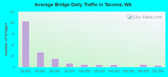
- 6,773,806Total average daily traffic
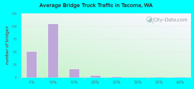
- 486,245Total average daily truck traffic
- National Bridge Inventory (NBI) Registered Bridges for Tacoma
- No street view available for this location
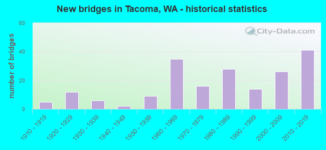
- New bridges - historical statistics
- 51910-1919
- 121920-1929
- 61930-1939
- 21940-1949
- 91950-1959
- 351960-1969
- 161970-1979
- 281980-1989
- 141990-1999
- 262000-2009
- 412010-2019
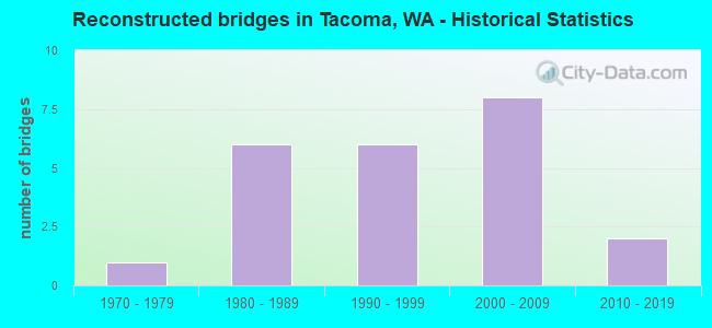
- Reconstructed bridges - Historical Statistics
- 11970-1979
- 61980-1989
- 61990-1999
- 82000-2009
- 22010-2019
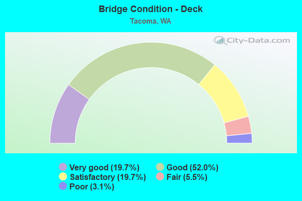
- Bridge Condition - Deck
- 19.7%Very good
- 52.0%Good
- 19.7%Satisfactory
- 5.5%Fair
- 3.1%Poor
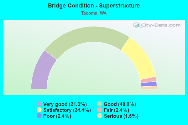
- Bridge Condition - Superstructure
- 21.3%Very good
- 48.0%Good
- 24.4%Satisfactory
- 2.4%Fair
- 2.4%Poor
- 1.6%Serious
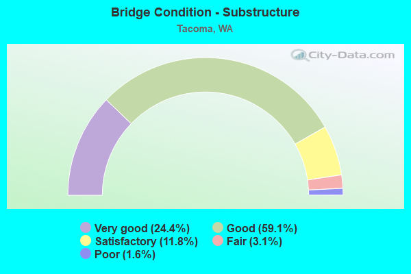
- Bridge Condition - Substructure
- 24.4%Very good
- 59.1%Good
- 11.8%Satisfactory
- 3.1%Fair
- 1.6%Poor
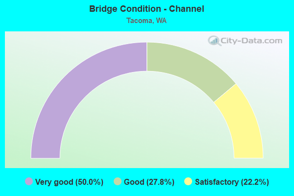
- Bridge Condition - Channel
- 50.0%Very good
- 27.8%Good
- 22.2%Satisfactory
Find on map >> Show street view
Structure Number: 17594F, Location: .37 N JCT I-5 (Lat: 47.234889, Lng: -122.466278), Route carried "under" structure: State highway 16, Year Built: 2010, Structure Length: 0. m, Average Daily Traffic: 88,176 (year 2019), Truck Traffic: 5%, Features Intersected: SR 16, Facility Carried by Structure: SPRAGUE AVE
Minimum Vertical Clearance: 7.29m (23.92ft), Kilometerpoint: 0.595, Lanes on structure: 3, Lanes under structure: 4, Material/Design: Prestressed concrete continuous, Design/Construction: Stringer/Multi-beam, Length of Maximum Span: 48.8m (160.1ft)
Find on map >> Show street view
Structure Number: 18189B, Location: JCT I-5 (Lat: 47.231083, Lng: -122.460444), Route carried "under" structure: State highway 16, Year Built: 2013, Structure Length: 0. m, Average Daily Traffic: 44,088 (year 2019), Truck Traffic: 5%, Features Intersected: SR 16 EB/SB, I-5 RAMPS, Facility Carried by Structure: S-S RAMP
Minimum Vertical Clearance: 5.51m (18.08ft), Kilometerpoint: 0.113, Lanes on structure: 1, Lanes under structure: 3, Material/Design: Steel continuous, Design/Construction: Stringer/Multi-beam, Length of Maximum Span: 67.1m (220.1ft)
Find on map >> Show street view
Structure Number: 18607A, Location: 1.4 N JCT SR 16 (Lat: 47.233869, Lng: -122.434194), Route carried "under" structure: Interstate 5, Year Built: 2016, Structure Length: 0. m, Average Daily Traffic: 171,606 (year 2019), Truck Traffic: 8%, Features Intersected: I-5, Facility Carried by Structure: PACIFIC AVE
Minimum Vertical Clearance: 5.11m (16.77ft), Kilometerpoint: 215.153, Lanes on structure: 4, Lanes under structure: 9, Material/Design: Prestressed concrete continuous, Design/Construction: Girder and Floorbeam System, Length of Maximum Span: 41.8m (137.1ft)
Find on map >> Show street view
Structure Number: 18607B, Location: 0.2 N JCT I-705 (Lat: 47.234778, Lng: -122.427944), Route carried "under" structure: Interstate 5, Year Built: 2018, Structure Length: 0. m, Average Daily Traffic: 171,606 (year 2019), Truck Traffic: 8%, Features Intersected: I-5, Facility Carried by Structure: MCKINLEY WAY
Minimum Vertical Clearance: 5.00m (16.40ft), Kilometerpoint: 215.668, Lanes on structure: 2, Lanes under structure: 7, Material/Design: Prestressed concrete continuous, Design/Construction: Stringer/Multi-beam, Length of Maximum Span: 44.2m (145.0ft)
Find on map >> Show street view
Structure Number: 18607C, Location: JCT I-5 (Lat: 47.232944, Lng: -122.433472), Route carried "under" structure: Ramp Interstate 7, Year Built: 2016, Structure Length: 0. m, Average Daily Traffic: 14,969 (year 2019), Truck Traffic: 4%, Features Intersected: I-705, SR 7, RAMPS, RR, Facility Carried by Structure: I-5
Minimum Vertical Clearance: 7.16m (23.49ft), Kilometerpoint: 94.308, Lanes on structure: 4, Lanes under structure: 8, Material/Design: Prestressed concrete continuous, Design/Construction: Girder and Floorbeam System, Length of Maximum Span: 51.8m (169.9ft)
Find on map >> Show street view
Structure Number: 18670A, Location: 0.1 N JCT SR 167 (Lat: 47.239072, Lng: -122.407394), Route carried "under" structure: State highway 5, Year Built: 2016, Structure Length: 0. m, Average Daily Traffic: 8,649 (year 2019), Truck Traffic: 6%, Features Intersected: RAMP TO I-5 NB, Facility Carried by Structure: N-N RAMP TO SR 167
Minimum Vertical Clearance: 5.36m (17.59ft), Kilometerpoint: 0.032, Lanes on structure: 1, Lanes under structure: 2, Material/Design: Steel continuous, Design/Construction: Girder and Floorbeam System, Length of Maximum Span: 71.6m (234.9ft)
Find on map >> Show street view
Structure Number: 18670A, Location: 0.1 N JCT SR 167 (Lat: 47.239072, Lng: -122.407394), Route carried "under" structure: Ramp State highway 5, Year Built: 2016, Structure Length: 0. m, Average Daily Traffic: 11,460 (year 2013), Features Intersected: RAMP TO I-5 NB, Facility Carried by Structure: N-N RAMP TO SR 167
Minimum Vertical Clearance: 5.08m (16.67ft), Kilometerpoint: 0.048, Lanes on structure: 1, Lanes under structure: 3, Material/Design: Steel continuous, Design/Construction: Girder and Floorbeam System, Length of Maximum Span: 71.6m (234.9ft)
Find on map >> Show street view
Structure Number: 18818A, Location: JCT I-5 (Lat: 47.229889, Lng: -122.459861), Route carried "under" structure: State highway 16, Year Built: 2017, Structure Length: 0. m, Average Daily Traffic: 44,088 (year 2019), Truck Traffic: 5%, Features Intersected: SR 16 EB/SB, E/S-N RAMP, Facility Carried by Structure: I-5 NB
Minimum Vertical Clearance: 5.03m (16.50ft), Kilometerpoint: 0.145, Lanes on structure: 4, Lanes under structure: 2, Material/Design: Prestressed concrete, Design/Construction: Stringer/Multi-beam, Length of Maximum Span: 46.6m (152.9ft)
Find on map >> Show street view
Structure Number: 18818B, Location: 0.1 N JCT I-5 (Lat: 47.232083, Lng: -122.462167), Route carried "under" structure: City street , Year Built: 2018, Structure Length: 0. m, Average Daily Traffic: 8,743 (year 2019), Truck Traffic: 12%, Features Intersected: S TACOMA WAY, Facility Carried by Structure: SR 16 HOV LANES
Minimum Vertical Clearance: 5.56m (18.24ft), Kilometerpoint: 12.939, Lanes on structure: 2, Lanes under structure: 4, Material/Design: Prestressed concrete, Design/Construction: Stringer/Multi-beam, Length of Maximum Span: 49.4m (162.1ft)
Find on map >> Show street view
Structure Number: 18818C, Location: 0.1 N JCT I-5 (Lat: 47.230519, Lng: -122.461333), Route carried "under" structure: State highway 16, Year Built: 2019, Structure Length: 0. m, Average Daily Traffic: 44,088 (year 2019), Truck Traffic: 5%, Features Intersected: I-5 SB, SR 16 W/NB, RMPS, Facility Carried by Structure: I-5 NB HOV LANE
Minimum Vertical Clearance: 12.19m (39.99ft), Kilometerpoint: 0.016, Lanes on structure: 1, Lanes under structure: 2, Material/Design: Concrete, Design/Construction: Stringer/Multi-beam, Length of Maximum Span: 46.0m (150.9ft)
Find on map >> Show street view
Structure Number: 18818C, Location: 0.1 N JCT I-5 (Lat: 47.230519, Lng: -122.461333), Route carried "under" structure: Ramp Interstate 5, Year Built: 2019, Structure Length: 0. m, Average Daily Traffic: 9,602 (year 2019), Truck Traffic: 5%, Features Intersected: I-5 SB, SR 16 W/NB, RMPS
Minimum Vertical Clearance: 5.69m (18.67ft), Kilometerpoint: 0.708, Lanes on structure: 1, Lanes under structure: 1, Material/Design: Concrete, Design/Construction: Stringer/Multi-beam, Length of Maximum Span: 46.0m (150.9ft)
Find on map >> Show street view
Structure Number: 18818C, Location: 0.1 N JCT I-5 (Lat: 47.230519, Lng: -122.461333), Route carried "under" structure: Interstate 5, Year Built: 2019, Structure Length: 0. m, Average Daily Traffic: 67,504 (year 2019), Truck Traffic: 11%, Features Intersected: I-5 SB, SR 16 W/NB, RMPS
Minimum Vertical Clearance: 5.23m (17.16ft), Kilometerpoint: 212.932, Lanes on structure: 1, Lanes under structure: 2, Material/Design: Concrete, Design/Construction: Stringer/Multi-beam, Length of Maximum Span: 46.0m (150.9ft)
Find on map >> Show street view
Structure Number: 18818D, Location: JCT I-5 & SR 16 (Lat: 47.230075, Lng: -122.461528), Route carried "under" structure: State highway 16, Year Built: 2019, Structure Length: 0. m, Average Daily Traffic: 44,088 (year 2019), Truck Traffic: 5%, Features Intersected: SR 16 EB/SB, HOV RAMPS, Facility Carried by Structure: I-5 SB
Minimum Vertical Clearance: 5.05m (16.57ft), Kilometerpoint: 0.016, Lanes on structure: 4, Lanes under structure: 2, Material/Design: Prestressed concrete continuous, Design/Construction: Stringer/Multi-beam, Length of Maximum Span: 51.8m (169.9ft)
Find on map >> Show street view
Structure Number: 200529, Location: 3.3 N JCT SR 16 (Lat: 47.304528, Lng: -122.514667), Route carried "under" structure: State highway 163, Year Built: 2017, Structure Length: 0. m, Average Daily Traffic: 2,424 (year 2019), Truck Traffic: 9%, Features Intersected: SR 163, Facility Carried by Structure: PED TRAIL
Minimum Vertical Clearance: 7.47m (24.51ft), Kilometerpoint: 5.279, Lanes under structure: 5, Material/Design: Concrete continuous, Design/Construction: Box Beam or Girders - Single/Spread, Length of Maximum Span: 36.0m (118.1ft)
Find on map >> Show street view
Structure Number: LF006A, Location: 1.3 N JCT I-5 (Lat: 47.245600, Lng: -122.435181), Route carried "under" structure: Interstate 705, Year Built: 2003, Structure Length: 0. m, Average Daily Traffic: 20,015 (year 2019), Truck Traffic: 4%, Features Intersected: I-705, BNSFRR, DOCK ST, Facility Carried by Structure: PED OVERPASS
Minimum Vertical Clearance: 9.70m (31.82ft), Kilometerpoint: 1.416, Lanes under structure: 10, Material/Design: Steel, Design/Construction: Stringer/Multi-beam, Length of Maximum Span: 32.0m (105.0ft)
Find on map >> Show street view
Structure Number: 84988, Location: 4.5 N JCT I-5 (Lat: 47.258725, Lng: -122.531308), Route carried "under" structure: State highway 16, Year Built: 1986, Structure Length: 0. m, Average Daily Traffic: 71,552 (year 2019), Truck Traffic: 5%, Features Intersected: SR 16, Facility Carried by Structure: SKYLINE PED
Minimum Vertical Clearance: 5.49m (18.01ft), Kilometerpoint: 7.097, Lanes under structure: 4, Material/Design: Prestressed concrete continuous, Design/Construction: Box Beam or Girders - Multiple, Length of Maximum Span: 109.7m (359.9ft)
Find on map >> Show street view
Structure Number: 85261, Location: 3.4 N JCT SR 512 (Lat: 47.213881, Lng: -122.462531), Route carried "under" structure: Interstate 5, Year Built: 1970, Structure Length: 0. m, Average Daily Traffic: 197,000 (year 2017), Truck Traffic: 11%, Features Intersected: INTERSTATE HWY 5, Facility Carried by Structure: SOUTH 48TH STREET
Minimum Vertical Clearance: 6.12m (20.08ft), Kilometerpoint: 211.130, Lanes on structure: 4, Lanes under structure: 8, Material/Design: Prestressed concrete, Design/Construction: Girder and Floorbeam System, Length of Maximum Span: 36.0m (118.1ft)
Find on map >> Show street view
Structure Number: 85267, Location: 00.1 EA JCT I-5 (Lat: 47.213883, Lng: -122.460039), Route carried "under" structure: City street 3210, Year Built: 1970, Structure Length: 0. m, Features Intersected: SOUTH 48TH STREET, Facility Carried by Structure: FOOTBRIDGE
Minimum Vertical Clearance: 5.18m (16.99ft), Kilometerpoint: 0.001, Lanes under structure: 4, Material/Design: Concrete, Design/Construction: Box Beam or Girders - Single/Spread, Length of Maximum Span: 22.6m (74.1ft)
Find on map >> Show street view
Structure Number: 89214, Location: 1.77 M E SR 163 (Lat: 47.294286, Lng: -122.499550), Route carried "under" structure: City street 2969, Year Built: 1920, Structure Length: 0. m, Average Daily Traffic: 1,893 (year 2021), Features Intersected: Waterview Street, Facility Carried by Structure: BNSF RR
Minimum Vertical Clearance: 4.60m (15.09ft), Kilometerpoint: 0.001, Lanes under structure: 2, Material/Design: Steel, Design/Construction: Girder and Floorbeam System, Length of Maximum Span: 12.2m (40.0ft)
Find on map >> Show street view
Structure Number: 89215, Location: 1.77 M E SR 163 (Lat: 47.286097, Lng: -122.488353), Route carried "under" structure: City street 215, Year Built: 1920, Structure Length: 0. m, Average Daily Traffic: 1,893 (year 2021), Features Intersected: Dale Street, Facility Carried by Structure: Railroad
Minimum Vertical Clearance: 4.60m (15.09ft), Kilometerpoint: 0.001, Lanes under structure: 2, Material/Design: Steel, Design/Construction: Girder and Floorbeam System, Length of Maximum Span: 12.2m (40.0ft)
Find on map >> Show street view
Structure Number: 89216, Location: 1.07 M E of I5 (Lat: 47.197381, Lng: -122.485047), Route carried "under" structure: City street 2968, Year Built: 1920, Structure Length: 0. m, Average Daily Traffic: 1,893 (year 2021), Features Intersected: South 66th Street, Facility Carried by Structure: Railroad
Minimum Vertical Clearance: 4.06m (13.32ft), Kilometerpoint: 0.001, Lanes under structure: 2, Material/Design: Steel, Design/Construction: Girder and Floorbeam System, Length of Maximum Span: 15.2m (49.9ft)
Find on map >> Show street view
Structure Number: 89217, Location: 0.53 M S SR16 (Lat: 47.227289, Lng: -122.487450), Route carried "under" structure: City street 3226, Year Built: 2000, Structure Length: 0. m, Average Daily Traffic: 1,893 (year 2021), Features Intersected: S. 36th Street, Facility Carried by Structure: Pedestrian path
Minimum Vertical Clearance: 5.82m (19.09ft), Kilometerpoint: 0.001, Lanes under structure: 3, Material/Design: Steel, Design/Construction: Truss - Thru, Length of Maximum Span: 33.5m (109.9ft)
Find on map >> Show street view
Structure Number: 89219, Location: 1.77 M E SR 163 (Lat: 47.280308, Lng: -122.478100), Route carried "under" structure: City street 3018, Year Built: 1920, Structure Length: 0. m, Average Daily Traffic: 1,893 (year 2021), Features Intersected: Alder Street, Facility Carried by Structure: Railroad
Minimum Vertical Clearance: 3.66m (12.01ft), Kilometerpoint: 0.001, Lanes under structure: 2, Material/Design: Steel, Design/Construction: Girder and Floorbeam System, Length of Maximum Span: 9.1m (29.9ft)
Find on map >> Show street view
Structure Number: 8922, Location: 0.14 M N of I5 (Lat: 47.241142, Lng: -122.410881), Route carried "under" structure: City street 3133, Year Built: 1950, Structure Length: 0. m, Average Daily Traffic: 2,825 (year 2021), Truck Traffic: 8%, Features Intersected: Portland Ave, Facility Carried by Structure: Railroad
Minimum Vertical Clearance: 5.08m (16.67ft), Kilometerpoint: 0.001, Lanes under structure: 4, Material/Design: Steel continuous, Design/Construction: Girder and Floorbeam System, Length of Maximum Span: 38.1m (125.0ft)
Find on map >> Show street view
Structure Number: 89221, Location: 0.12 M, N of I5 (Lat: 47.239619, Lng: -122.409725), Route carried "under" structure: City street 284, Year Built: 2005, Structure Length: 0. m, Average Daily Traffic: 1,727 (year 2021), Truck Traffic: 8%, Features Intersected: Bay Street, Facility Carried by Structure: Railroad
Minimum Vertical Clearance: 4.88m (16.01ft), Kilometerpoint: 0.001, Lanes under structure: 2, Material/Design: Concrete, Design/Construction: Slab, Length of Maximum Span: 9.1m (29.9ft)
Find on map >> Show street view
Structure Number: 89223, Location: 0.37 M N or I5 (Lat: 47.238364, Lng: -122.435264), Route carried "under" structure: City street 3081, Year Built: 1920, Structure Length: 0. m, Average Daily Traffic: 2,572 (year 2021), Truck Traffic: 5%, Features Intersected: Pacific Avenue, Facility Carried by Structure: Railroad
Minimum Vertical Clearance: 5.03m (16.50ft), Kilometerpoint: 0.579, Lanes under structure: 4, Material/Design: Steel, Design/Construction: Stringer/Multi-beam, Length of Maximum Span: 33.5m (109.9ft)
Find on map >> Show street view
Structure Number: 89224, Location: 0.26 M N of I5 (Lat: 47.239711, Lng: -122.424789), Route carried "under" structure: City street 2974, Year Built: 1920, Structure Length: 0. m, Average Daily Traffic: 986 (year 2021), Truck Traffic: 2%, Features Intersected: E 26th St and E G St, Facility Carried by Structure: Railroad
Minimum Vertical Clearance: 5.26m (17.26ft), Kilometerpoint: 0.001, Lanes under structure: 2, Material/Design: Steel, Design/Construction: Girder and Floorbeam System, Length of Maximum Span: 38.1m (125.0ft)
Find on map >> Show street view
Structure Number: 89225, Location: 0.16 M N of I5 (Lat: 47.240219, Lng: -122.420092), Route carried "under" structure: City street 382, Year Built: 2005, Structure Length: 0. m, Average Daily Traffic: 527 (year 2021), Truck Traffic: 5%, Features Intersected: J Street, Facility Carried by Structure: Railroad
Minimum Vertical Clearance: 2.79m (9.15ft), Kilometerpoint: 0.001, Lanes under structure: 2, Material/Design: Concrete, Design/Construction: Girder and Floorbeam System, Length of Maximum Span: 19.8m (65.0ft)