Bridge Statistics for Tacoma, Washington (WA)
Condition, Traffic, Stress, Structural Evaluation, Project Costs
- National Bridge Inventory (NBI) Statistics
- 194Number of bridges
- 8,533ft / 2,601mTotal length
- $1,875,638,000Total costs
- 6,773,806Total average daily traffic
- 486,245Total average daily truck traffic
- National Bridge Inventory (NBI) Registered Bridges for Tacoma
- No street view available for this location
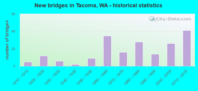
- New bridges - historical statistics
- 51910-1919
- 121920-1929
- 61930-1939
- 21940-1949
- 91950-1959
- 351960-1969
- 161970-1979
- 281980-1989
- 141990-1999
- 262000-2009
- 412010-2019
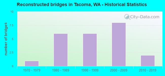
- Reconstructed bridges - Historical Statistics
- 11970-1979
- 61980-1989
- 61990-1999
- 82000-2009
- 22010-2019
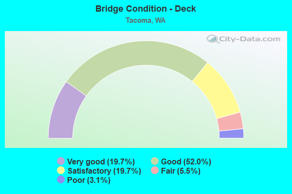
- Bridge Condition - Deck
- 19.7%Very good
- 52.0%Good
- 19.7%Satisfactory
- 5.5%Fair
- 3.1%Poor
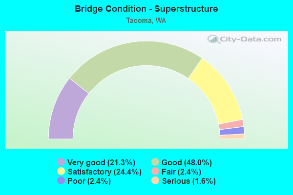
- Bridge Condition - Superstructure
- 21.3%Very good
- 48.0%Good
- 24.4%Satisfactory
- 2.4%Fair
- 2.4%Poor
- 1.6%Serious
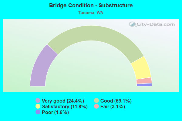
- Bridge Condition - Substructure
- 24.4%Very good
- 59.1%Good
- 11.8%Satisfactory
- 3.1%Fair
- 1.6%Poor
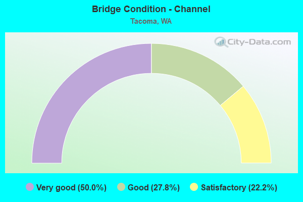
- Bridge Condition - Channel
- 50.0%Very good
- 27.8%Good
- 22.2%Satisfactory
Find on map >> Show street view
Structure Number: 12648A, Location: 0.9 N JCT I-5 (Lat: 47.246650, Lng: -122.435322), Route carried "on" structure: Ramp Interstate 705, Year Built: 1987, Status: Open, Structure Length: 37.86m (124.21ft), Average Daily Traffic: 10,307 (year 2012), Truck Traffic: 3%, Average Future Daily Traffic: 17,728 (year 2036), Design Load: HS 20+Mod, Features Intersected: 15TH ST-PLRR, I-705
Minimum Vertical Clearance: 30+ m (98+ ft), Kilometerpoint: 0.386, Lanes on structure: 2, Lanes under structure: 4, Owner: State Highway Agency, Approaching Roadway Width: 11.6m (38.1ft), Material/Design: Prestressed concrete continuous, Design/Construction: Box Beam or Girders - Multiple, Number Of Spans In Main Unit: 8, Length of Maximum Span: 45.7m (149.9ft), Curb-To-Curb Width: 8.5m (27.9ft), Out-to-Out Width: 9.4m (30.8ft)
Condition: Deck: Good, Superstructure: Good, Substructure: Good, Operating Rating: 89.8 metric tons, Method Used To Determine Operating Rating: Load Factor (LF), Inventory Rating: 53.5 metric tons, Method Used To Determine Inventory Rating: Load Factor (LF), Structural Evaluation: Better than present minimum criteria, Deck Geometry: High priority of corrective action, Underclear: High priority of corrective action, Approach Roadway Alignment: Equal to present minimum criteria, Length Of Structure Improvement: 37.86m (124.21ft), Designated Inspection Frequency: Every 24 months, Inspection Date: November 2018, Bridge Improvement Cost: $9,936,000, Roadway Improvement Cost: $1,987,000, Total Project Cost: $19,872,000 ( Estimate for 2014), Deck Structure Type: Concrete Cast-file-Place, Wearing Surface/Protective System: Wearing Surface: Latex Concrete, Deck Protection: Epoxy Coated Reinforcing
Find on map >> Show street view
Structure Number: 12648B, Location: 1.1 N JCT I-5 (Lat: 47.249453, Lng: -122.436189), Route carried "on" structure: Ramp Interstate 705, Year Built: 1987, Status: Open, Structure Length: 15.54m (50.98ft), Average Daily Traffic: 3,690 (year 2007), Truck Traffic: 3%, Average Future Daily Traffic: 6,900 (year 2036), Design Load: HS 20+Mod, Features Intersected: N-N RAMP, Facility Carried by Structure: S 15TH ST
Minimum Vertical Clearance: 30+ m (98+ ft), Kilometerpoint: 0.225, Lanes on structure: 1, Lanes under structure: 4, Owner: State Highway Agency, Approaching Roadway Width: 9.8m (32.2ft), Material/Design: Prestressed concrete continuous, Design/Construction: Box Beam or Girders - Single/Spread, Number Of Spans In Main Unit: 4, Length of Maximum Span: 50.3m (165.0ft), Curb-To-Curb Width: 9.6m (31.5ft), Out-to-Out Width: 10.4m (34.1ft)
Condition: Deck: Good, Superstructure: Good, Substructure: Good, Operating Rating: 62.6 metric tons, Method Used To Determine Operating Rating: Load Factor (LF), Inventory Rating: 38.1 metric tons, Method Used To Determine Inventory Rating: Load Factor (LF), Structural Evaluation: Better than present minimum criteria, Deck Geometry: Superior to present desirable criteria, Underclear: Superior to present desirable criteria, Approach Roadway Alignment: Equal to present minimum criteria, Length Of Structure Improvement: 15.54m (50.98ft), Designated Inspection Frequency: Every 24 months, Inspection Date: November 2018, Bridge Improvement Cost: $3,468,000, Roadway Improvement Cost: $694,000, Total Project Cost: $6,936,000 ( Estimate for 2014), Deck Structure Type: Concrete Cast-file-Place, Wearing Surface/Protective System: Wearing Surface: Monolithic Concrete, Deck Protection: Epoxy Coated Reinforcing
Find on map >> Show street view
Structure Number: 12701A, Location: PT DEFIANCE-TACOMA (Lat: 47.305778, Lng: -122.514139), Route carried "on" structure: State highway 163, Year Built: 1958, Year Reconstructed: 1994, Status: Open, Structure Length: 2.47m (8.10ft), Average Daily Traffic: 2,330 (year 2010), Truck Traffic: 1%, Average Future Daily Traffic: 3,784 (year 2036), Design Load: H 15, Features Intersected: PUGET SOUND, Facility Carried by Structure: TACOMA-VASHON TRAF
Minimum Vertical Clearance: 30+ m (98+ ft), Kilometerpoint: 5.423, Lanes on structure: 1, Toll: Toll bridge, Owner: State Highway Agency, Approaching Roadway Width: 6.1m (20.0ft), Material/Design: Wood or Timber, Design/Construction: Stringer/Multi-beam, Number Of Spans In Main Unit: 7, Length of Maximum Span: 4.9m (16.1ft), Curb or Sidewalk Widths: Left: 1.2m (3.9ft), Right: 0.0m, Curb-To-Curb Width: 7.3m (24.0ft), Out-to-Out Width: 9.1m (29.9ft)
Condition: Deck: Fair, Superstructure: Satisfactory, Substructure: Fair, Channel: Good, Operating Rating: 37.2 metric tons, Method Used To Determine Operating Rating: Allowable Stress (AS), Inventory Rating: 27.2 metric tons, Method Used To Determine Inventory Rating: Allowable Stress (AS), Structural Evaluation: Somewhat better than minimum adequacy, Deck Geometry: High priority of replacement, Waterway Adequacy: Equal to present desirable criteria, Approach Roadway Alignment: Equal to present desirable criteria, Length Of Structure Improvement: 2.47m (8.10ft), Designated Inspection Frequency: Every 24 months, Underwater Inspection Frequency: Every 48 months, Inspection Date: Febuary 2020, Underwater Inspection Date: October 2019, Bridge Improvement Cost: $356,000, Roadway Improvement Cost: $71,000, Total Project Cost: $713,000 ( Estimate for 2014), Deck Structure Type: Wood or Timber, Wearing Surface/Protective System: Wearing Surface: Bituminous
Find on map >> Show street view
Structure Number: 12747A, Location: 1.1 N JCT I-5 (Lat: 47.248147, Lng: -122.435453), Route carried "on" structure: Interstate 705, Year Built: 1986, Status: Open, Structure Length: 58.22m (191.01ft), Average Daily Traffic: 26,987 (year 2019), Truck Traffic: 4%, Average Future Daily Traffic: 39,077 (year 2039), Design Load: HS 20+Mod, Features Intersected: 15TH ST & BNRR,PRAIRIE L
Minimum Vertical Clearance: 30+ m (98+ ft), Kilometerpoint: 1.706, Lanes on structure: 2, Lanes under structure: 2, Base Highway Network: Yes, Owner: State Highway Agency, Approaching Roadway Width: 11.6m (38.1ft), Material/Design: Prestressed concrete continuous, Design/Construction: Box Beam or Girders - Single/Spread, Number Of Spans In Main Unit: 13, Length of Maximum Span: 45.7m (149.9ft), Curb-To-Curb Width: 11.7m (38.4ft), Out-to-Out Width: 12.7m (41.7ft)
Condition: Deck: Good, Superstructure: Good, Substructure: Good, Operating Rating: 19.8 metric tons, Method Used To Determine Operating Rating: Load and Resistance Factor Rating (LRFR) rating reported by rating factor(RF) method using HL-93 loadings, Inventory Rating: 15.2 metric tons, Method Used To Determine Inventory Rating: Load and Resistance Factor Rating (LRFR) rating reported by rating factor(RF) method using HL-93 loadings, Structural Evaluation: High priority of corrective action, Deck Geometry: Equal to present minimum criteria, Underclear: Equal to present minimum criteria, Approach Roadway Alignment: Equal to present desirable criteria, Length Of Structure Improvement: 58.22m (191.01ft), Designated Inspection Frequency: Every 24 months, Inspection Date: November 2021, Bridge Improvement Cost: $15,280,000, Roadway Improvement Cost: $3,056,000, Total Project Cost: $30,560,000 ( Estimate for 2014), Deck Structure Type: Concrete Cast-file-Place, Wearing Surface/Protective System: Wearing Surface: Monolithic Concrete, Deck Protection: Epoxy Coated Reinforcing
Find on map >> Show street view
Structure Number: 12747B, Location: 1.1 N JCT I-5 (Lat: 47.248889, Lng: -122.435833), Route carried "on" structure: Interstate 705, Year Built: 1987, Status: Open, Structure Length: 37.95m (124.51ft), Average Daily Traffic: 26,987 (year 2019), Truck Traffic: 4%, Average Future Daily Traffic: 39,077 (year 2039), Design Load: HS 20+Mod, Features Intersected: 15TH ST & BNRR
Minimum Vertical Clearance: 30+ m (98+ ft), Kilometerpoint: 1.754, Lanes on structure: 2, Lanes under structure: 2, Base Highway Network: Yes, Owner: State Highway Agency, Approaching Roadway Width: 12.2m (40.0ft), Material/Design: Prestressed concrete continuous, Design/Construction: Box Beam or Girders - Multiple, Number Of Spans In Main Unit: 9, Length of Maximum Span: 45.7m (149.9ft), Curb-To-Curb Width: 12.2m (40.0ft), Out-to-Out Width: 13.1m (43.0ft)
Condition: Deck: Good, Superstructure: Good, Substructure: Good, Operating Rating: 33.6 metric tons, Method Used To Determine Operating Rating: Load Factor (LF), Inventory Rating: 20.0 metric tons, Method Used To Determine Inventory Rating: Load Factor (LF), Structural Evaluation: Somewhat better than minimum adequacy, Deck Geometry: Better than present minimum criteria, Underclear: Better than present minimum criteria, Approach Roadway Alignment: Equal to present desirable criteria, Length Of Structure Improvement: 37.95m (124.51ft), Designated Inspection Frequency: Every 24 months, Inspection Date: November 2018, Bridge Improvement Cost: $10,458,000, Roadway Improvement Cost: $2,092,000, Total Project Cost: $20,916,000 ( Estimate for 2014), Deck Structure Type: Concrete Cast-file-Place, Wearing Surface/Protective System: Wearing Surface: Latex Concrete, Deck Protection: Epoxy Coated Reinforcing
Find on map >> Show street view
Structure Number: 12747C, Location: 1.2 N JCT I-5 (Lat: 47.250278, Lng: -122.436389), Route carried "on" structure: Ramp Interstate 705, Year Built: 1987, Status: Open, Structure Length: 6.71m (22.01ft), Average Daily Traffic: 6,123 (year 2012), Truck Traffic: 3%, Average Future Daily Traffic: 10,532 (year 2036), Design Load: HS 20+Mod, Features Intersected: FLAT TERRAIN
Minimum Vertical Clearance: 30+ m (98+ ft), Kilometerpoint: 0.048, Lanes on structure: 1, Owner: State Highway Agency, Approaching Roadway Width: 13.4m (44.0ft), Material/Design: Prestressed concrete continuous, Design/Construction: Box Beam or Girders - Multiple, Number Of Spans In Main Unit: 2, Length of Maximum Span: 33.5m (109.9ft), Curb-To-Curb Width: 10.7m (35.1ft), Out-to-Out Width: 11.6m (38.1ft)
Condition: Deck: Good, Superstructure: Good, Substructure: Good, Operating Rating: 88.9 metric tons, Method Used To Determine Operating Rating: Load Factor (LF), Inventory Rating: 52.6 metric tons, Method Used To Determine Inventory Rating: Load Factor (LF), Structural Evaluation: Better than present minimum criteria, Deck Geometry: Superior to present desirable criteria, Approach Roadway Alignment: Equal to present desirable criteria, Length Of Structure Improvement: 6.71m (22.01ft), Designated Inspection Frequency: Every 24 months, Inspection Date: November 2018, Bridge Improvement Cost: $2,024,000, Roadway Improvement Cost: $405,000, Total Project Cost: $4,048,000 ( Estimate for 2014), Deck Structure Type: Concrete Cast-file-Place, Wearing Surface/Protective System: Wearing Surface: Latex Concrete, Deck Protection: Epoxy Coated Reinforcing
Find on map >> Show street view
Structure Number: 12985A, Location: 3.0 N JCT I-5 (Lat: 47.249936, Lng: -122.511158), Route carried "on" structure: State highway 16, Year Built: 1986, Status: Open, Structure Length: 5.91m (19.39ft), Average Daily Traffic: 47,850 (year 2019), Truck Traffic: 5%, Average Future Daily Traffic: 69,286 (year 2039), Design Load: HS 20+Mod, Features Intersected: SOUTH 12TH STREET
Minimum Vertical Clearance: 30+ m (98+ ft), Kilometerpoint: 4.973, Lanes on structure: 4, Lanes under structure: 5, Base Highway Network: Yes, Owner: State Highway Agency, Approaching Roadway Width: 20.4m (66.9ft), Skew: 3 degrees, Material/Design: Concrete continuous, Design/Construction: Frame, Number Of Spans In Main Unit: 3, Length of Maximum Span: 27.4m (89.9ft), Curb-To-Curb Width: 20.5m (67.3ft), Out-to-Out Width: 22.0m (72.2ft)
Condition: Deck: Good, Superstructure: Good, Substructure: Good, Operating Rating: 29.2 metric tons, Method Used To Determine Operating Rating: Load and Resistance Factor Rating (LRFR) rating reported by rating factor(RF) method using HL-93 loadings, Inventory Rating: 22.4 metric tons, Method Used To Determine Inventory Rating: Load and Resistance Factor Rating (LRFR) rating reported by rating factor(RF) method using HL-93 loadings, Structural Evaluation: Somewhat better than minimum adequacy, Deck Geometry: Equal to present minimum criteria, Underclear: Somewhat better than minimum adequacy, Approach Roadway Alignment: Equal to present desirable criteria, Length Of Structure Improvement: 5.91m (19.39ft), Designated Inspection Frequency: Every 24 months, Inspection Date: March 2020, Bridge Improvement Cost: $2,677,000, Roadway Improvement Cost: $535,000, Total Project Cost: $5,354,000 ( Estimate for 2014), Deck Structure Type: Concrete Cast-file-Place, Wearing Surface/Protective System: Wearing Surface: Monolithic Concrete, Deck Protection: Epoxy Coated Reinforcing
Find on map >> Show street view
Structure Number: 12992A, Location: JCT I-5 (Lat: 47.235000, Lng: -122.431667), Route carried "on" structure: Interstate 705, Year Built: 1988, Status: Open, Structure Length: 44.23m (145.11ft), Average Daily Traffic: 14,969 (year 2019), Truck Traffic: 4%, Average Future Daily Traffic: 21,675 (year 2039), Design Load: HS 20+Mod, Features Intersected: CHEHALIS WESTERN RR
Minimum Vertical Clearance: 30+ m (98+ ft), Kilometerpoint: 0.097, Lanes on structure: 1, Lanes under structure: 3, Base Highway Network: Yes, Owner: State Highway Agency, Approaching Roadway Width: 15.8m (51.8ft), Material/Design: Prestressed concrete continuous, Design/Construction: Box Beam or Girders - Multiple, Number Of Spans In Main Unit: 11, Length of Maximum Span: 42.7m (140.1ft), Curb-To-Curb Width: 9.4m (30.8ft), Out-to-Out Width: 12.2m (40.0ft)
Condition: Deck: Very good, Superstructure: Good, Substructure: Good, Operating Rating: 71.7 metric tons, Method Used To Determine Operating Rating: Load Factor (LF), Inventory Rating: 42.6 metric tons, Method Used To Determine Inventory Rating: Load Factor (LF), Structural Evaluation: Better than present minimum criteria, Deck Geometry: Meets minimum limits, Underclear: Equal to present minimum criteria, Approach Roadway Alignment: Equal to present desirable criteria, Length Of Structure Improvement: 44.23m (145.11ft), Designated Inspection Frequency: Every 24 months, Inspection Date: August 2021, Bridge Improvement Cost: $15,671,000, Roadway Improvement Cost: $3,134,000, Total Project Cost: $31,342,000 ( Estimate for 2014), Deck Structure Type: Concrete Cast-file-Place, Wearing Surface/Protective System: Wearing Surface: Latex Concrete, Deck Protection: Epoxy Coated Reinforcing
Find on map >> Show street view
Structure Number: 12992B, Location: 0.3 N JCT I-5 (Lat: 47.235358, Lng: -122.431214), Route carried "on" structure: Interstate 705, Year Built: 1988, Status: Open, Structure Length: 78.88m (258.79ft), Average Daily Traffic: 20,833 (year 2019), Truck Traffic: 4%, Average Future Daily Traffic: 30,166 (year 2039), Design Load: HS 20+Mod, Features Intersected: I-705 NB, RAMP, STREETS+
Minimum Vertical Clearance: 30+ m (98+ ft), Kilometerpoint: 0.547, Lanes on structure: 2, Lanes under structure: 16, Base Highway Network: Yes, Owner: State Highway Agency, Approaching Roadway Width: 11.6m (38.1ft), Material/Design: Prestressed concrete continuous, Design/Construction: Box Beam or Girders - Single/Spread, Number Of Spans In Main Unit: 18, Length of Maximum Span: 51.8m (169.9ft), Curb-To-Curb Width: 11.6m (38.1ft), Out-to-Out Width: 12.5m (41.0ft)
Condition: Deck: Very good, Superstructure: Satisfactory, Substructure: Good, Operating Rating: 30.1 metric tons, Method Used To Determine Operating Rating: Load and Resistance Factor Rating (LRFR) rating reported by rating factor(RF) method using HL-93 loadings, Inventory Rating: 23.3 metric tons, Method Used To Determine Inventory Rating: Load and Resistance Factor Rating (LRFR) rating reported by rating factor(RF) method using HL-93 loadings, Structural Evaluation: Somewhat better than minimum adequacy, Deck Geometry: Equal to present minimum criteria, Underclear: High priority of corrective action, Approach Roadway Alignment: Equal to present desirable criteria, Length Of Structure Improvement: 78.88m (258.79ft), Designated Inspection Frequency: Every 24 months, Inspection Date: August 2021, Bridge Improvement Cost: $20,704,000, Roadway Improvement Cost: $4,141,000, Total Project Cost: $41,408,000 ( Estimate for 2014), Deck Structure Type: Concrete Cast-file-Place, Wearing Surface/Protective System: Wearing Surface: Latex Concrete, Deck Protection: Epoxy Coated Reinforcing
Find on map >> Show street view
Structure Number: 12992C, Location: 0.2 N JCT I-5 (Lat: 47.235506, Lng: -122.431539), Route carried "on" structure: Ramp Interstate 705, Year Built: 1988, Status: Open, Structure Length: 12.74m (41.80ft), Average Daily Traffic: 4,510 (year 2012), Truck Traffic: 3%, Average Future Daily Traffic: 7,757 (year 2036), Design Load: HS 20+Mod, Features Intersected: TERRAIN
Minimum Vertical Clearance: 30+ m (98+ ft), Kilometerpoint: 0.161, Lanes on structure: 1, Owner: State Highway Agency, Approaching Roadway Width: 8.8m (28.9ft), Material/Design: Prestressed concrete continuous, Design/Construction: Box Beam or Girders - Single/Spread, Number Of Spans In Main Unit: 3, Length of Maximum Span: 47.2m (154.9ft), Curb-To-Curb Width: 7.9m (25.9ft), Out-to-Out Width: 8.8m (28.9ft)
Condition: Deck: Good, Superstructure: Satisfactory, Substructure: Good, Operating Rating: 88.9 metric tons, Method Used To Determine Operating Rating: Load Factor (LF), Inventory Rating: 52.6 metric tons, Method Used To Determine Inventory Rating: Load Factor (LF), Structural Evaluation: Equal to present minimum criteria, Deck Geometry: Equal to present desirable criteria, Approach Roadway Alignment: Equal to present desirable criteria, Length Of Structure Improvement: 12.74m (41.80ft), Designated Inspection Frequency: Every 24 months, Inspection Date: August 2021, Bridge Improvement Cost: $2,592,000, Roadway Improvement Cost: $518,000, Total Project Cost: $5,183,000 ( Estimate for 2014), Deck Structure Type: Concrete Cast-file-Place, Wearing Surface/Protective System: Wearing Surface: Latex Concrete, Deck Protection: Epoxy Coated Reinforcing
Find on map >> Show street view
Structure Number: 12992D, Location: 0.2 N JCT I-5 (Lat: 47.233456, Lng: -122.433975), Route carried "on" structure: Interstate 705, Year Built: 1988, Status: Open, Structure Length: 102.53m (336.38ft), Average Daily Traffic: 20,833 (year 2019), Truck Traffic: 4%, Average Future Daily Traffic: 30,166 (year 2039), Design Load: HS 20+Mod, Features Intersected: I-705 SB, RAMP, STREETS+
Minimum Vertical Clearance: 30+ m (98+ ft), Kilometerpoint: 0.418, Lanes on structure: 2, Lanes under structure: 19, Base Highway Network: Yes, Owner: State Highway Agency, Approaching Roadway Width: 11.6m (38.1ft), Material/Design: Prestressed concrete continuous, Design/Construction: Box Beam or Girders - Multiple, Number Of Spans In Main Unit: 23, Length of Maximum Span: 51.8m (169.9ft), Curb-To-Curb Width: 11.6m (38.1ft), Out-to-Out Width: 12.5m (41.0ft)
Condition: Deck: Good, Superstructure: Good, Substructure: Good, Operating Rating: 54.4 metric tons, Method Used To Determine Operating Rating: Load Factor (LF), Inventory Rating: 32.7 metric tons, Method Used To Determine Inventory Rating: Load Factor (LF), Structural Evaluation: Better than present minimum criteria, Deck Geometry: Equal to present minimum criteria, Underclear: Equal to present minimum criteria, Approach Roadway Alignment: Equal to present desirable criteria, Length Of Structure Improvement: 102.53m (336.38ft), Designated Inspection Frequency: Every 24 months, Inspection Date: August 2021, Bridge Improvement Cost: $26,912,000, Roadway Improvement Cost: $5,382,000, Total Project Cost: $53,824,000 ( Estimate for 2014), Deck Structure Type: Concrete Cast-file-Place, Wearing Surface/Protective System: Wearing Surface: Latex Concrete, Deck Protection: Epoxy Coated Reinforcing
Find on map >> Show street view
Structure Number: 12992E, Location: 0.1 N JCT I-5 (Lat: 47.236028, Lng: -122.432194), Route carried "on" structure: Interstate 705, Year Built: 1988, Status: Open, Structure Length: 3.81m (12.50ft), Average Daily Traffic: 20,833 (year 2019), Truck Traffic: 4%, Average Future Daily Traffic: 30,166 (year 2039), Design Load: HS 20+Mod, Features Intersected: TERRAIN
Minimum Vertical Clearance: 30+ m (98+ ft), Kilometerpoint: 0.274, Lanes on structure: 2, Base Highway Network: Yes, Owner: State Highway Agency, Approaching Roadway Width: 11.6m (38.1ft), Material/Design: Prestressed concrete continuous, Design/Construction: Box Beam or Girders - Multiple, Number Of Spans In Main Unit: 1, Length of Maximum Span: 38.1m (125.0ft), Curb-To-Curb Width: 11.6m (38.1ft), Out-to-Out Width: 13.6m (44.6ft)
Condition: Deck: Very good, Superstructure: Very good, Substructure: Very good, Operating Rating: 89.8 metric tons, Method Used To Determine Operating Rating: Load Factor (LF), Inventory Rating: 74.4 metric tons, Method Used To Determine Inventory Rating: Load Factor (LF), Structural Evaluation: Equal to present desirable criteria, Deck Geometry: Equal to present minimum criteria, Approach Roadway Alignment: Equal to present desirable criteria, Length Of Structure Improvement: 3.81m (12.50ft), Designated Inspection Frequency: Every 24 months, Inspection Date: August 2021, Bridge Improvement Cost: $1,000,000, Roadway Improvement Cost: $200,000, Total Project Cost: $2,000,000 ( Estimate for 2014), Deck Structure Type: Concrete Cast-file-Place, Wearing Surface/Protective System: Wearing Surface: Latex Concrete, Deck Protection: Epoxy Coated Reinforcing
Find on map >> Show street view
Structure Number: 13207A, Location: 2.1 N JCT SR 512 (Lat: 47.190417, Lng: -122.463139), Route carried "on" structure: City street , Year Built: 1988, Status: Open, Structure Length: 1.65m (5.41ft), Average Daily Traffic: 31,732 (year 2007), Truck Traffic: 2%, Average Future Daily Traffic: 56,578 (year 2036), Design Load: HS 20+Mod, Features Intersected: S-W RAMP, Facility Carried by Structure: 74TH - 72ND ST
Minimum Vertical Clearance: 30+ m (98+ ft), Kilometerpoint: 0.113, Lanes on structure: 8, Lanes under structure: 1, Base Highway Network: Yes, Owner: State Highway Agency, Approaching Roadway Width: 26.8m (87.9ft), Skew: 3 degrees, Material/Design: Concrete, Design/Construction: Slab, Number Of Spans In Main Unit: 1, Length of Maximum Span: 16.5m (54.1ft), Curb or Sidewalk Widths: Left: 1.8m (5.9ft), Right: 1.8m (5.9ft), Curb-To-Curb Width: 26.8m (87.9ft), Out-to-Out Width: 30.9m (101.4ft)
Condition: Deck: Satisfactory, Superstructure: Good, Substructure: Good, Operating Rating: 44.7 metric tons, Method Used To Determine Operating Rating: Load and Resistance Factor Rating (LRFR) rating reported by rating factor(RF) method using HL-93 loadings, Inventory Rating: 34.3 metric tons, Method Used To Determine Inventory Rating: Load and Resistance Factor Rating (LRFR) rating reported by rating factor(RF) method using HL-93 loadings, Structural Evaluation: Better than present minimum criteria, Deck Geometry: High priority of replacement, Underclear: Equal to present desirable criteria, Approach Roadway Alignment: Equal to present desirable criteria, Length Of Structure Improvement: 1.65m (5.41ft), Designated Inspection Frequency: Every 24 months, Inspection Date: November 2021, Bridge Improvement Cost: $972,000, Roadway Improvement Cost: $194,000, Total Project Cost: $1,944,000 ( Estimate for 2014), Deck Structure Type: Concrete Cast-file-Place, Wearing Surface/Protective System: Wearing Surface: Monolithic Concrete, Deck Protection: Epoxy Coated Reinforcing
Find on map >> Show street view
Structure Number: 13783A, Location: 2.6 N JCT I-5 (Lat: 47.242861, Lng: -122.505056), Route carried "on" structure: City street , Year Built: 1992, Status: Open, Structure Length: 7.28m (23.88ft), Average Daily Traffic: 24,237 (year 2016), Truck Traffic: 1%, Average Future Daily Traffic: 39,458 (year 2038), Design Load: HS 20+Mod, Features Intersected: SR 16, Facility Carried by Structure: SOUTH 19TH ST
Minimum Vertical Clearance: 30+ m (98+ ft), Kilometerpoint: 0.080, Lanes on structure: 6, Lanes under structure: 8, Base Highway Network: Yes, Owner: State Highway Agency, Approaching Roadway Width: 21.3m (69.9ft), Skew: 3 degrees, Material/Design: Prestressed concrete continuous, Design/Construction: Box Beam or Girders - Multiple, Number Of Spans In Main Unit: 2, Length of Maximum Span: 39.9m (130.9ft), Curb or Sidewalk Widths: Left: 2.1m (6.9ft), Right: 2.1m (6.9ft), Curb-To-Curb Width: 23.1m (75.8ft), Out-to-Out Width: 27.9m (91.5ft)
Condition: Deck: Good, Superstructure: Good, Substructure: Good, Operating Rating: 52.6 metric tons, Method Used To Determine Operating Rating: Load Factor (LF), Inventory Rating: 31.7 metric tons, Method Used To Determine Inventory Rating: Load Factor (LF), Structural Evaluation: Better than present minimum criteria, Deck Geometry: Meets minimum limits, Underclear: Meets minimum limits, Approach Roadway Alignment: Equal to present desirable criteria, Length Of Structure Improvement: 7.28m (23.88ft), Designated Inspection Frequency: Every 24 months, Inspection Date: March 2020, Bridge Improvement Cost: $3,442,000, Roadway Improvement Cost: $688,000, Total Project Cost: $6,883,000 ( Estimate for 2014), Deck Structure Type: Concrete Cast-file-Place, Wearing Surface/Protective System: Wearing Surface: Monolithic Concrete, Deck Protection: Epoxy Coated Reinforcing
Find on map >> Show street view
Structure Number: 14409A, Location: 1.6 N JCT I-705 (Lat: 47.247250, Lng: -122.400861), Route carried "on" structure: State highway 509, Year Built: 1996, Status: Open, Structure Length: 4.11m (13.48ft), Average Daily Traffic: 30,286 (year 2019), Truck Traffic: 5%, Average Future Daily Traffic: 43,854 (year 2039), Design Load: HS 25 or greater, Features Intersected: MILWAUKEE WAY
Minimum Vertical Clearance: 30+ m (98+ ft), Kilometerpoint: 2.639, Lanes on structure: 4, Lanes under structure: 5, Base Highway Network: Yes, Owner: State Highway Agency, Approaching Roadway Width: 21.9m (71.9ft), Skew: 30 degrees, Material/Design: Prestressed concrete, Design/Construction: Stringer/Multi-beam, Number Of Spans In Main Unit: 1, Length of Maximum Span: 39.6m (129.9ft), Curb-To-Curb Width: 21.9m (71.9ft), Out-to-Out Width: 23.5m (77.1ft)
Condition: Deck: Good, Superstructure: Good, Substructure: Good, Operating Rating: 89.8 metric tons, Method Used To Determine Operating Rating: Load Factor (LF), Inventory Rating: 51.7 metric tons, Method Used To Determine Inventory Rating: Load Factor (LF), Structural Evaluation: Better than present minimum criteria, Deck Geometry: Better than present minimum criteria, Underclear: High priority of corrective action, Approach Roadway Alignment: Equal to present desirable criteria, Length Of Structure Improvement: 4.11m (13.48ft), Designated Inspection Frequency: Every 24 months, Inspection Date: December 2020, Bridge Improvement Cost: $1,998,000, Roadway Improvement Cost: $400,000, Total Project Cost: $3,996,000 ( Estimate for 2014), Deck Structure Type: Concrete Cast-file-Place, Wearing Surface/Protective System: Wearing Surface: Monolithic Concrete, Deck Protection: Epoxy Coated Reinforcing
Find on map >> Show street view
Structure Number: 14409B, Location: 0.7 N JCT I-705 (Lat: 47.244408, Lng: -122.418436), Route carried "on" structure: State highway 509, Year Built: 1996, Status: Open, Structure Length: 109.24m (358.40ft), Average Daily Traffic: 30,286 (year 2019), Truck Traffic: 5%, Average Future Daily Traffic: 43,854 (year 2039), Design Load: HS 25 or greater, Features Intersected: RIVER, RR, PORTLAND AVE
Minimum Vertical Clearance: 30+ m (98+ ft), Kilometerpoint: 1.271, Lanes on structure: 4, Lanes under structure: 8, Base Highway Network: Yes, Owner: State Highway Agency, Approaching Roadway Width: 26.2m (86.0ft), Skew: 30 degrees, Material/Design: Prestressed concrete continuous, Design/Construction: Segmental Box Girder, Number Of Spans In Main Unit: 4, Number Of Approach Spans: 17, Length of Maximum Span: 135.6m (444.9ft), Curb-To-Curb Width: 21.9m (71.9ft), Out-to-Out Width: 23.1m (75.8ft)
Condition: Deck: Good, Superstructure: Good, Substructure: Good, Channel: Very good, Operating Rating: 89.8 metric tons, Method Used To Determine Operating Rating: Load Factor (LF), Inventory Rating: 70.7 metric tons, Method Used To Determine Inventory Rating: Load Factor (LF), Structural Evaluation: Better than present minimum criteria, Deck Geometry: Better than present minimum criteria, Underclear: Meets minimum limits, Waterway Adequacy: Equal to present desirable criteria, Approach Roadway Alignment: Equal to present desirable criteria, Length Of Structure Improvement: 109.24m (358.40ft), Designated Inspection Frequency: Every 24 months, Other Special Inspection Frequency: Every 24 months, Inspection Date: August 2020, Other Special Inspection Date: August 2020, Bridge Improvement Cost: $63,078,000, Roadway Improvement Cost: $12,616,000, Total Project Cost: $126,157,000 ( Estimate for 2014), Deck Structure Type: Concrete Cast-file-Place, Wearing Surface/Protective System: Wearing Surface: Latex Concrete, Deck Protection: Epoxy Coated Reinforcing
Find on map >> Show street view
Structure Number: 14414A, Location: 3.0 E JCT I-705 (Lat: 47.247417, Lng: -122.372556), Route carried "on" structure: State highway 509, Year Built: 1995, Status: Open, Structure Length: 1.86m (6.10ft), Average Daily Traffic: 16,827 (year 2019), Truck Traffic: 13%, Average Future Daily Traffic: 24,365 (year 2039), Design Load: HS 25 or greater, Features Intersected: WAPATO CREEK
Minimum Vertical Clearance: 30+ m (98+ ft), Kilometerpoint: 4.764, Lanes on structure: 2, Base Highway Network: Yes, Owner: State Highway Agency, Approaching Roadway Width: 11.0m (36.1ft), Skew: 1 degrees, Material/Design: Prestressed concrete, Design/Construction: Box Beam or Girders - Single/Spread, Number Of Spans In Main Unit: 1, Length of Maximum Span: 16.8m (55.1ft), Curb-To-Curb Width: 11.0m (36.1ft), Out-to-Out Width: 11.9m (39.0ft)
Condition: Deck: Good, Superstructure: Good, Substructure: Good, Channel: Satisfactory, Operating Rating: 89.8 metric tons, Method Used To Determine Operating Rating: Load Factor (LF), Inventory Rating: 75.3 metric tons, Method Used To Determine Inventory Rating: Load Factor (LF), Structural Evaluation: Better than present minimum criteria, Deck Geometry: Somewhat better than minimum adequacy, Waterway Adequacy: Equal to present desirable criteria, Approach Roadway Alignment: Equal to present desirable criteria, Length Of Structure Improvement: 1.86m (6.10ft), Designated Inspection Frequency: Every 48 months, Inspection Date: November 2021, Bridge Improvement Cost: $464,000, Roadway Improvement Cost: $93,000, Total Project Cost: $927,000 ( Estimate for 2014), Deck Structure Type: Concrete Cast-file-Place, Wearing Surface/Protective System: Wearing Surface: Monolithic Concrete, Deck Protection: Epoxy Coated Reinforcing
Find on map >> Show street view
Structure Number: 14507A, Location: 0.1 N JCT I-705 (Lat: 47.243333, Lng: -122.433778), Route carried "on" structure: State highway 509, Year Built: 1996, Status: Open, Structure Length: 30.24m (99.21ft), Average Daily Traffic: 38,003 (year 2019), Truck Traffic: 5%, Average Future Daily Traffic: 55,028 (year 2039), Design Load: HS 25 or greater, Features Intersected: THEA FOSS WATRWAY & D ST
Minimum Vertical Clearance: 30+ m (98+ ft), Kilometerpoint: 0.097, Lanes on structure: 4, Lanes under structure: 2, Base Highway Network: Yes, Owner: State Highway Agency, Approaching Roadway Width: 21.9m (71.9ft), Skew: 30 degrees, Material/Design: Prestressed concrete continuous, Design/Construction: Stayed Girder, Number Of Spans In Main Unit: 2, Number Of Approach Spans: 2, Length of Maximum Span: 106.7m (350.1ft), Curb-To-Curb Width: 21.9m (71.9ft), Out-to-Out Width: 28.9m (94.8ft)
Condition: Deck: Satisfactory, Superstructure: Satisfactory, Substructure: Good, Channel: Very good, Operating Rating: 21.1 metric tons, Method Used To Determine Operating Rating: Load and Resistance Factor Rating (LRFR) rating reported by rating factor(RF) method using HL-93 loadings, Inventory Rating: 12.6 metric tons, Method Used To Determine Inventory Rating: Load and Resistance Factor Rating (LRFR) rating reported by rating factor(RF) method using HL-93 loadings, Structural Evaluation: High priority of corrective action, Deck Geometry: Better than present minimum criteria, Underclear: Better than present minimum criteria, Waterway Adequacy: Equal to present desirable criteria, Approach Roadway Alignment: Equal to present desirable criteria, Length Of Structure Improvement: 30.24m (99.21ft), Designated Inspection Frequency: Every 24 months, Underwater Inspection Frequency: Every 60 months, Other Special Inspection Frequency: Every 24 months, Inspection Date: September 2021, Underwater Inspection Date: May 2017, Other Special Inspection Date: September 2021, Bridge Improvement Cost: $14,682,000, Roadway Improvement Cost: $2,936,000, Total Project Cost: $29,363,000 ( Estimate for 2014), Deck Structure Type: Concrete Cast-file-Place, Wearing Surface/Protective System: Wearing Surface: Monolithic Concrete, Deck Protection: Epoxy Coated Reinforcing
Find on map >> Show street view
Structure Number: 14520A, Location: 0.7 N JCT I-705 (Lat: 47.245278, Lng: -122.412917), Route carried "on" structure: Ramp State highway 509, Year Built: 1996, Status: Open, Structure Length: 30.39m (99.70ft), Average Daily Traffic: 3,877 (year 2019), Truck Traffic: 4%, Average Future Daily Traffic: 5,613 (year 2039), Design Load: HS 25 or greater, Features Intersected: RAILROAD & EAST RIVER ST
Minimum Vertical Clearance: 30+ m (98+ ft), Kilometerpoint: 0.001, Lanes on structure: 1, Lanes under structure: 2, Owner: State Highway Agency, Approaching Roadway Width: 7.9m (25.9ft), Material/Design: Prestressed concrete continuous, Design/Construction: Stringer/Multi-beam, Number Of Spans In Main Unit: 7, Number Of Approach Spans: 3, Length of Maximum Span: 42.7m (140.1ft), Curb-To-Curb Width: 7.9m (25.9ft), Out-to-Out Width: 8.5m (27.9ft)
Condition: Deck: Good, Superstructure: Good, Substructure: Good, Operating Rating: 49.0 metric tons, Method Used To Determine Operating Rating: Load Factor (LF), Inventory Rating: 29.0 metric tons, Method Used To Determine Inventory Rating: Load Factor (LF), Structural Evaluation: Better than present minimum criteria, Deck Geometry: Equal to present desirable criteria, Underclear: Meets minimum limits, Approach Roadway Alignment: Equal to present desirable criteria, Length Of Structure Improvement: 30.39m (99.70ft), Designated Inspection Frequency: Every 48 months, Inspection Date: October 2018, Bridge Improvement Cost: $5,583,000, Roadway Improvement Cost: $1,117,000, Total Project Cost: $11,166,000 ( Estimate for 2014), Deck Structure Type: Concrete Cast-file-Place, Wearing Surface/Protective System: Wearing Surface: Monolithic Concrete, Deck Protection: Epoxy Coated Reinforcing
Find on map >> Show street view
Structure Number: 14520B, Location: 0.7 N JCT I-705 (Lat: 47.244306, Lng: -122.418306), Route carried "on" structure: Ramp State highway 509, Year Built: 1996, Status: Open, Structure Length: 35.66m (116.99ft), Average Daily Traffic: 3,840 (year 2019), Truck Traffic: 4%, Average Future Daily Traffic: 5,560 (year 2039), Design Load: HS 25 or greater, Features Intersected: RAILROAD
Minimum Vertical Clearance: 30+ m (98+ ft), Kilometerpoint: 0.129, Lanes on structure: 1, Owner: State Highway Agency, Approaching Roadway Width: 7.9m (25.9ft), Material/Design: Prestressed concrete continuous, Design/Construction: Stringer/Multi-beam, Number Of Spans In Main Unit: 11, Length of Maximum Span: 44.5m (146.0ft), Curb-To-Curb Width: 7.9m (25.9ft), Out-to-Out Width: 8.5m (27.9ft)
Condition: Deck: Good, Superstructure: Good, Substructure: Good, Operating Rating: 54.4 metric tons, Method Used To Determine Operating Rating: Load Factor (LF), Inventory Rating: 40.8 metric tons, Method Used To Determine Inventory Rating: Load Factor (LF), Structural Evaluation: Better than present minimum criteria, Deck Geometry: Equal to present desirable criteria, Underclear: Equal to present minimum criteria, Approach Roadway Alignment: Equal to present desirable criteria, Length Of Structure Improvement: 35.66m (116.99ft), Designated Inspection Frequency: Every 24 months, Inspection Date: November 2018, Bridge Improvement Cost: $6,552,000, Roadway Improvement Cost: $1,310,000, Total Project Cost: $13,104,000 ( Estimate for 2014), Deck Structure Type: Concrete Cast-file-Place, Wearing Surface/Protective System: Wearing Surface: Latex Concrete, Deck Protection: Epoxy Coated Reinforcing
Find on map >> Show street view
Structure Number: 14747A, Location: JCT I-705 (Lat: 47.243222, Lng: -122.435000), Route carried "on" structure: State highway 509, Year Built: 1996, Status: Open, Structure Length: 9.48m (31.10ft), Average Daily Traffic: 38,003 (year 2019), Truck Traffic: 5%, Average Future Daily Traffic: 55,028 (year 2039), Design Load: HS 25 or greater, Features Intersected: I-705, BNRR, DOCK STREET
Minimum Vertical Clearance: 30+ m (98+ ft), Kilometerpoint: 0.001, Lanes on structure: 8, Lanes under structure: 7, Base Highway Network: Yes, Owner: State Highway Agency, Approaching Roadway Width: 25.9m (85.0ft), Skew: 9 degrees, Material/Design: Prestressed concrete continuous, Design/Construction: Box Beam or Girders - Multiple, Number Of Spans In Main Unit: 3, Length of Maximum Span: 46.0m (150.9ft), Curb-To-Curb Width: 34.1m (111.9ft), Out-to-Out Width: 59.9m (196.5ft)
Condition: Deck: Good, Superstructure: Good, Substructure: Good, Operating Rating: 89.8 metric tons, Method Used To Determine Operating Rating: Load Factor (LF), Inventory Rating: 63.5 metric tons, Method Used To Determine Inventory Rating: Load Factor (LF), Structural Evaluation: Better than present minimum criteria, Deck Geometry: Somewhat better than minimum adequacy, Underclear: High priority of corrective action, Approach Roadway Alignment: Equal to present desirable criteria, Length Of Structure Improvement: 9.48m (31.10ft), Designated Inspection Frequency: Every 24 months, Inspection Date: November 2021, Bridge Improvement Cost: $5,412,000, Roadway Improvement Cost: $1,082,000, Total Project Cost: $10,823,000 ( Estimate for 2014), Deck Structure Type: Concrete Cast-file-Place, Wearing Surface/Protective System: Wearing Surface: Monolithic Concrete, Deck Protection: Epoxy Coated Reinforcing
Find on map >> Show street view
Structure Number: 14747B, Location: JCT I-705 (Lat: 47.243719, Lng: -122.434397), Route carried "on" structure: Ramp State highway 509, Year Built: 1996, Status: Open, Structure Length: 6.07m (19.91ft), Average Daily Traffic: 6,673 (year 2012), Truck Traffic: 3%, Average Future Daily Traffic: 11,478 (year 2036), Design Load: HS 25 or greater, Features Intersected: TERRAIN
Minimum Vertical Clearance: 30+ m (98+ ft), Kilometerpoint: 0.001, Lanes on structure: 2, Owner: State Highway Agency, Approaching Roadway Width: 11.0m (36.1ft), Material/Design: Prestressed concrete continuous, Design/Construction: Box Beam or Girders - Multiple, Number Of Spans In Main Unit: 2, Length of Maximum Span: 30.2m (99.1ft), Curb-To-Curb Width: 11.0m (36.1ft), Out-to-Out Width: 11.9m (39.0ft)
Condition: Deck: Good, Superstructure: Good, Substructure: Good, Operating Rating: 89.8 metric tons, Method Used To Determine Operating Rating: Load Factor (LF), Inventory Rating: 59.9 metric tons, Method Used To Determine Inventory Rating: Load Factor (LF), Structural Evaluation: Better than present minimum criteria, Deck Geometry: Better than present minimum criteria, Approach Roadway Alignment: Equal to present desirable criteria, Length Of Structure Improvement: 6.07m (19.91ft), Designated Inspection Frequency: Every 48 months, Inspection Date: November 2021, Bridge Improvement Cost: $1,512,000, Roadway Improvement Cost: $302,000, Total Project Cost: $3,025,000 ( Estimate for 2014), Deck Structure Type: Concrete Cast-file-Place, Wearing Surface/Protective System: Wearing Surface: Monolithic Concrete, Deck Protection: Epoxy Coated Reinforcing
Find on map >> Show street view
Structure Number: 14747C, Location: JCT SR 509 (Lat: 47.241583, Lng: -122.433528), Route carried "on" structure: Ramp Interstate 705, Year Built: 1996, Status: Open, Structure Length: 14.60m (47.90ft), Average Daily Traffic: 10,881 (year 2012), Truck Traffic: 3%, Average Future Daily Traffic: 18,715 (year 2036), Design Load: HS 25 or greater, Features Intersected: TERRAIN
Minimum Vertical Clearance: 30+ m (98+ ft), Kilometerpoint: 0.241, Lanes on structure: 3, Owner: State Highway Agency, Approaching Roadway Width: 9.1m (29.9ft), Material/Design: Prestressed concrete continuous, Design/Construction: Box Beam or Girders - Multiple, Number Of Spans In Main Unit: 4, Length of Maximum Span: 44.2m (145.0ft), Curb-To-Curb Width: 9.2m (30.2ft), Out-to-Out Width: 13.6m (44.6ft)
Condition: Deck: Satisfactory, Superstructure: Good, Substructure: Good, Operating Rating: 89.8 metric tons, Method Used To Determine Operating Rating: Load Factor (LF), Inventory Rating: 58.0 metric tons, Method Used To Determine Inventory Rating: Load Factor (LF), Structural Evaluation: Better than present minimum criteria, Deck Geometry: High priority of replacement, Approach Roadway Alignment: Equal to present desirable criteria, Length Of Structure Improvement: 14.60m (47.90ft), Designated Inspection Frequency: Every 24 months, Inspection Date: September 2021, Bridge Improvement Cost: $3,066,000, Roadway Improvement Cost: $613,000, Total Project Cost: $6,131,000 ( Estimate for 2014), Deck Structure Type: Concrete Cast-file-Place, Wearing Surface/Protective System: Wearing Surface: Monolithic Concrete, Deck Protection: Epoxy Coated Reinforcing
Find on map >> Show street view
Structure Number: 15833A, Location: 1.7 N JCT I-705 (Lat: 47.247472, Lng: -122.385639), Route carried "on" structure: City street , Year Built: 2001, Status: Open, Structure Length: 6.49m (21.29ft), Average Daily Traffic: 11,919 (year 2007), Truck Traffic: 10%, Average Future Daily Traffic: 21,252 (year 2036), Design Load: HS 25 or greater, Features Intersected: SR 509, Facility Carried by Structure: PORT OF TACOMA RD
Minimum Vertical Clearance: 30+ m (98+ ft), Kilometerpoint: 0.048, Lanes on structure: 5, Lanes under structure: 6, Base Highway Network: Yes, Owner: State Highway Agency, Approaching Roadway Width: 21.0m (68.9ft), Material/Design: Prestressed concrete continuous, Design/Construction: Stringer/Multi-beam, Number Of Spans In Main Unit: 2, Length of Maximum Span: 31.1m (102.0ft), Curb or Sidewalk Widths: Left: 2.0m (6.6ft), Right: 2.0m (6.6ft), Curb-To-Curb Width: 21.0m (68.9ft), Out-to-Out Width: 25.6m (84.0ft)
Condition: Deck: Satisfactory, Superstructure: Good, Substructure: Good, Operating Rating: 67.1 metric tons, Method Used To Determine Operating Rating: Load Factor (LF), Inventory Rating: 40.8 metric tons, Method Used To Determine Inventory Rating: Load Factor (LF), Structural Evaluation: Better than present minimum criteria, Deck Geometry: Somewhat better than minimum adequacy, Underclear: Somewhat better than minimum adequacy, Approach Roadway Alignment: Equal to present desirable criteria, Length Of Structure Improvement: 6.49m (21.29ft), Designated Inspection Frequency: Every 24 months, Inspection Date: November 2021, Bridge Improvement Cost: $3,024,000, Roadway Improvement Cost: $605,000, Total Project Cost: $6,049,000 ( Estimate for 2014), Deck Structure Type: Concrete Cast-file-Place, Wearing Surface/Protective System: Wearing Surface: Monolithic Concrete, Deck Protection: Epoxy Coated Reinforcing
Find on map >> Show street view
Structure Number: 15833B, Location: 1.7 N JCT I-705 (Lat: 47.248028, Lng: -122.385575), Route carried "on" structure: City street 509, Year Built: 2001, Status: Open, Structure Length: 13.17m (43.21ft), Average Daily Traffic: 12,594 (year 2021), Truck Traffic: 20%, Average Future Daily Traffic: 22,600 (year 2043), Design Load: HS 25 or greater, Features Intersected: NFRC LINES, Facility Carried by Structure: PORT OF TACOMA RD
Minimum Vertical Clearance: 30+ m (98+ ft), Kilometerpoint: 3.782, Lanes on structure: 5, Base Highway Network: Yes, Owner: City or Municipal Highway Agency, Approaching Roadway Width: 21.9m (71.9ft), Skew: 20 degrees, Material/Design: Concrete continuous, Design/Construction: Box Beam or Girders - Multiple, Number Of Spans In Main Unit: 5, Length of Maximum Span: 29.9m (98.1ft), Curb or Sidewalk Widths: Left: 2.0m (6.6ft), Right: 2.0m (6.6ft), Curb-To-Curb Width: 21.9m (71.9ft), Out-to-Out Width: 25.8m (84.6ft)
Condition: Deck: Good, Superstructure: Good, Substructure: Good, Operating Rating: 24.0 metric tons, Method Used To Determine Operating Rating: Load and Resistance Factor Rating (LRFR) rating reported by rating factor(RF) method using HL-93 loadings, Inventory Rating: 18.5 metric tons, Method Used To Determine Inventory Rating: Load and Resistance Factor Rating (LRFR) rating reported by rating factor(RF) method using HL-93 loadings, Structural Evaluation: Meets minimum limits, Deck Geometry: Somewhat better than minimum adequacy, Underclear: Somewhat better than minimum adequacy, Approach Roadway Alignment: Equal to present desirable criteria, Length Of Structure Improvement: 13.47m (44.19ft), Designated Inspection Frequency: Every 24 months, Inspection Date: June 2021, Bridge Improvement Cost: $13,083,000, Roadway Improvement Cost: $2,617,000, Total Project Cost: $26,166,000 ( Estimate for 2014), Deck Structure Type: Concrete Cast-file-Place, Wearing Surface/Protective System: Wearing Surface: Monolithic Concrete, Deck Protection: Epoxy Coated Reinforcing
Find on map >> Show street view
Structure Number: 15935A, Location: 4.3 N JCT SR 512 (Lat: 47.222925, Lng: -122.464075), Route carried "on" structure: City street , Year Built: 2001, Status: Open, Structure Length: 9.88m (32.41ft), Average Daily Traffic: 29,024 (year 2007), Truck Traffic: 2%, Average Future Daily Traffic: 51,750 (year 2036), Design Load: HS 25 or greater, Features Intersected: I-5, Facility Carried by Structure: 38TH ST
Minimum Vertical Clearance: 30+ m (98+ ft), Kilometerpoint: 0.322, Lanes on structure: 7, Lanes under structure: 12, Base Highway Network: Yes, Owner: State Highway Agency, Approaching Roadway Width: 32.3m (106.0ft), Material/Design: Prestressed concrete continuous, Design/Construction: Box Beam or Girders - Single/Spread, Number Of Spans In Main Unit: 2, Length of Maximum Span: 50.0m (164.0ft), Curb-To-Curb Width: 32.4m (106.3ft), Out-to-Out Width: 33.1m (108.6ft)
Condition: Deck: Good, Superstructure: Good, Substructure: Good, Operating Rating: 89.8 metric tons, Method Used To Determine Operating Rating: Load Factor (LF), Inventory Rating: 89.8 metric tons, Method Used To Determine Inventory Rating: Load Factor (LF), Structural Evaluation: Better than present minimum criteria, Deck Geometry: Superior to present desirable criteria, Underclear: Equal to present minimum criteria, Approach Roadway Alignment: Equal to present desirable criteria, Length Of Structure Improvement: 9.88m (32.41ft), Designated Inspection Frequency: Every 24 months, Inspection Date: November 2021, Bridge Improvement Cost: $6,998,000, Roadway Improvement Cost: $1,400,000, Total Project Cost: $13,997,000 ( Estimate for 2014), Deck Structure Type: Concrete Cast-file-Place, Wearing Surface/Protective System: Wearing Surface: Monolithic Concrete, Deck Protection: Epoxy Coated Reinforcing
Find on map >> Show street view
Structure Number: 16441A, Location: 5.1 N JCT I-5 (Lat: 47.264028, Lng: -122.546694), Route carried "on" structure: State highway 16, Year Built: 2007, Status: Open, Structure Length: 169.77m (556.99ft), Average Daily Traffic: 43,392 (year 2019), Truck Traffic: 5%, Average Future Daily Traffic: 62,831 (year 2039), Design Load: HS 25 or greater, Features Intersected: TACOMA NARROWS
Minimum Vertical Clearance: 30+ m (98+ ft), Kilometerpoint: 11.780, Lanes on structure: 4, Base Highway Network: Yes, Toll: Toll bridge, Owner: State Toll Authority, Maintenance Responsibility: State Highway Agency, Approaching Roadway Width: 17.1m (56.1ft), Navigation Control: Yes ( Vertical Clearance: 54.6m (179.1ft), Horizontal Clearance: 782.7m (2,567.9ft)), Material/Design: Steel continuous, Design/Construction: Suspension, Number Of Spans In Main Unit: 3, Number Of Approach Spans: 2, Length of Maximum Span: 853.4m (2,799.9ft), Curb or Sidewalk Widths: Left: 3.0m (9.8ft), Right: 0.0m, Curb-To-Curb Width: 17.1m (56.1ft), Out-to-Out Width: 20.5m (67.3ft)
Condition: Deck: Good, Superstructure: Good, Substructure: Good, Channel: Very good, Operating Rating: 68.0 metric tons, Method Used To Determine Operating Rating: Load Factor (LF), Inventory Rating: 40.8 metric tons, Method Used To Determine Inventory Rating: Load Factor (LF), Structural Evaluation: Better than present minimum criteria, Deck Geometry: Meets minimum limits, Underclear: Equal to present desirable criteria, Waterway Adequacy: Equal to present desirable criteria, Approach Roadway Alignment: Equal to present desirable criteria, Length Of Structure Improvement: 169.77m (556.99ft), Designated Inspection Frequency: Every 24 months, Critical Feature Inspection Frequency: Every 24 months, Underwater Inspection Frequency: Every 60 months, Other Special Inspection Frequency: Every 24 months, Inspection Date: August 2020, Critical Feature Inspection Date: August 2020, Underwater Inspection Date: Febuary 2018, Other Special Inspection Date: August 2020, Bridge Improvement Cost: $64,612,000, Roadway Improvement Cost: $12,922,000, Total Project Cost: $129,224,000 ( Estimate for 2014), Deck Structure Type: Steel plate, Wearing Surface/Protective System: Wearing Surface: Bituminous, Membrane: Other
Find on map >> Show street view
Structure Number: 16767A, Location: 1.9 N JCT I-5 (Lat: 47.235611, Lng: -122.497833), Route carried "on" structure: Ramp State highway 16, Year Built: 2006, Status: Open, Structure Length: 9.45m (31.00ft), Average Daily Traffic: 12,683 (year 2019), Truck Traffic: 6%, Average Future Daily Traffic: 18,364 (year 2039), Design Load: HL 93, Features Intersected: SR 16
Minimum Vertical Clearance: 30+ m (98+ ft), Kilometerpoint: 0.386, Lanes on structure: 1, Lanes under structure: 6, Owner: State Highway Agency, Approaching Roadway Width: 8.2m (26.9ft), Material/Design: Steel continuous, Design/Construction: Stringer/Multi-beam, Number Of Spans In Main Unit: 2, Length of Maximum Span: 51.8m (169.9ft), Curb-To-Curb Width: 8.2m (26.9ft), Out-to-Out Width: 9.1m (29.9ft)
Condition: Deck: Good, Superstructure: Very good, Substructure: Very good, Operating Rating: 89.8 metric tons, Method Used To Determine Operating Rating: Load Factor (LF), Inventory Rating: 78.0 metric tons, Method Used To Determine Inventory Rating: Load Factor (LF), Structural Evaluation: Equal to present desirable criteria, Deck Geometry: Superior to present desirable criteria, Underclear: Meets minimum limits, Approach Roadway Alignment: Equal to present desirable criteria, Length Of Structure Improvement: 9.45m (31.00ft), Designated Inspection Frequency: Every 24 months, Inspection Date: May 2021, Bridge Improvement Cost: $1,798,000, Roadway Improvement Cost: $360,000, Total Project Cost: $3,596,000 ( Estimate for 2014), Deck Structure Type: Concrete Cast-file-Place, Wearing Surface/Protective System: Wearing Surface: Monolithic Concrete, Deck Protection: Epoxy Coated Reinforcing
Find on map >> Show street view
Structure Number: 16767C, Location: 3.0 N JCT I-5 (Lat: 47.249936, Lng: -122.510808), Route carried "on" structure: State highway 16, Year Built: 2006, Status: Open, Structure Length: 4.11m (13.48ft), Average Daily Traffic: 47,850 (year 2019), Truck Traffic: 5%, Average Future Daily Traffic: 69,286 (year 2039), Design Load: HL 93, Features Intersected: SOUTH 12TH STREET
Minimum Vertical Clearance: 30+ m (98+ ft), Kilometerpoint: 4.973, Lanes on structure: 4, Lanes under structure: 5, Base Highway Network: Yes, Owner: State Highway Agency, Approaching Roadway Width: 21.0m (68.9ft), Skew: 3 degrees, Material/Design: Prestressed concrete, Design/Construction: Stringer/Multi-beam, Number Of Spans In Main Unit: 1, Length of Maximum Span: 39.3m (128.9ft), Curb or Sidewalk Widths: Left: 0.0m, Right: 4.9m (16.1ft), Curb-To-Curb Width: 20.7m (67.9ft), Out-to-Out Width: 26.8m (87.9ft)
Condition: Deck: Good, Superstructure: Good, Substructure: Good, Operating Rating: 89.8 metric tons, Method Used To Determine Operating Rating: Load Factor (LF), Inventory Rating: 68.0 metric tons, Method Used To Determine Inventory Rating: Load Factor (LF), Structural Evaluation: Better than present minimum criteria, Deck Geometry: Equal to present minimum criteria, Underclear: Meets minimum limits, Approach Roadway Alignment: Equal to present desirable criteria, Length Of Structure Improvement: 4.11m (13.48ft), Designated Inspection Frequency: Every 24 months, Inspection Date: March 2020, Bridge Improvement Cost: $1,917,000, Roadway Improvement Cost: $383,000, Total Project Cost: $3,834,000 ( Estimate for 2014), Deck Structure Type: Concrete Cast-file-Place, Wearing Surface/Protective System: Wearing Surface: Monolithic Concrete, Deck Protection: Epoxy Coated Reinforcing
Find on map >> Show street view
Structure Number: 16767D, Location: 3.5 N JCT I-5 (Lat: 47.255139, Lng: -122.513750), Route carried "on" structure: State highway 16, Year Built: 2006, Status: Open, Structure Length: 6.43m (21.10ft), Average Daily Traffic: 35,865 (year 2019), Truck Traffic: 5%, Average Future Daily Traffic: 51,932 (year 2039), Design Load: HL 93, Features Intersected: 6TH AVE
Minimum Vertical Clearance: 30+ m (98+ ft), Kilometerpoint: 5.601, Lanes on structure: 3, Lanes under structure: 4, Base Highway Network: Yes, Owner: State Highway Agency, Approaching Roadway Width: 18.0m (59.1ft), Skew: 1 degrees, Material/Design: Prestressed concrete continuous, Design/Construction: Box Beam or Girders - Multiple, Number Of Spans In Main Unit: 3, Length of Maximum Span: 36.6m (120.1ft), Curb-To-Curb Width: 18.0m (59.1ft), Out-to-Out Width: 18.9m (62.0ft)
Condition: Deck: Good, Superstructure: Good, Substructure: Good, Operating Rating: 86.2 metric tons, Method Used To Determine Operating Rating: Load Factor (LF), Inventory Rating: 51.7 metric tons, Method Used To Determine Inventory Rating: Load Factor (LF), Structural Evaluation: Better than present minimum criteria, Deck Geometry: Better than present minimum criteria, Underclear: Better than present minimum criteria, Approach Roadway Alignment: Equal to present desirable criteria, Length Of Structure Improvement: 6.43m (21.10ft), Designated Inspection Frequency: Every 24 months, Inspection Date: March 2021, Bridge Improvement Cost: $2,574,000, Roadway Improvement Cost: $515,000, Total Project Cost: $5,148,000 ( Estimate for 2014), Deck Structure Type: Concrete Cast-file-Place, Wearing Surface/Protective System: Wearing Surface: Monolithic Concrete, Deck Protection: Epoxy Coated Reinforcing
Find on map >> Show street view
Structure Number: 16767E, Location: 3.7 N JCT I-5 (Lat: 47.257167, Lng: -122.515500), Route carried "on" structure: State highway 16, Year Built: 2006, Status: Open, Structure Length: 8.20m (26.90ft), Average Daily Traffic: 35,865 (year 2019), Truck Traffic: 5%, Average Future Daily Traffic: 51,932 (year 2039), Design Load: HL 93, Features Intersected: SR 163/PEARL ST
Minimum Vertical Clearance: 30+ m (98+ ft), Kilometerpoint: 5.842, Lanes on structure: 3, Lanes under structure: 5, Base Highway Network: Yes, Owner: State Highway Agency, Approaching Roadway Width: 18.0m (59.1ft), Skew: 3 degrees, Material/Design: Prestressed concrete continuous, Design/Construction: Box Beam or Girders - Multiple, Number Of Spans In Main Unit: 3, Length of Maximum Span: 48.5m (159.1ft), Curb-To-Curb Width: 18.0m (59.1ft), Out-to-Out Width: 18.9m (62.0ft)
Condition: Deck: Good, Superstructure: Good, Substructure: Good, Operating Rating: 89.8 metric tons, Method Used To Determine Operating Rating: Load Factor (LF), Inventory Rating: 83.4 metric tons, Method Used To Determine Inventory Rating: Load Factor (LF), Structural Evaluation: Better than present minimum criteria, Deck Geometry: Better than present minimum criteria, Underclear: Equal to present minimum criteria, Approach Roadway Alignment: Equal to present desirable criteria, Length Of Structure Improvement: 8.20m (26.90ft), Designated Inspection Frequency: Every 24 months, Inspection Date: March 2020, Bridge Improvement Cost: $3,282,000, Roadway Improvement Cost: $656,000, Total Project Cost: $6,564,000 ( Estimate for 2014), Deck Structure Type: Concrete Cast-file-Place, Wearing Surface/Protective System: Wearing Surface: Monolithic Concrete, Deck Protection: Epoxy Coated Reinforcing
Find on map >> Show street view
Structure Number: 16958A, Location: 0.5 N JCT SR 16 (Lat: 47.230056, Lng: -122.451333), Route carried "on" structure: Interstate 5, Year Built: 2006, Status: Open, Structure Length: 7.07m (23.20ft), Average Daily Traffic: 60,078 (year 2019), Truck Traffic: 10%, Average Future Daily Traffic: 86,992 (year 2039), Design Load: HL 93, Features Intersected: S M ST
Minimum Vertical Clearance: 30+ m (98+ ft), Kilometerpoint: 1.674, Lanes on structure: 4, Lanes under structure: 4, Base Highway Network: Yes, Owner: State Highway Agency, Approaching Roadway Width: 21.3m (69.9ft), Material/Design: Prestressed concrete continuous, Design/Construction: Stringer/Multi-beam, Number Of Spans In Main Unit: 3, Length of Maximum Span: 25.0m (82.0ft), Curb-To-Curb Width: 21.3m (69.9ft), Out-to-Out Width: 22.3m (73.2ft)
Condition: Deck: Satisfactory, Superstructure: Good, Substructure: Good, Operating Rating: 82.5 metric tons, Method Used To Determine Operating Rating: Load Factor (LF), Inventory Rating: 49.0 metric tons, Method Used To Determine Inventory Rating: Load Factor (LF), Structural Evaluation: Better than present minimum criteria, Deck Geometry: Better than present minimum criteria, Underclear: Somewhat better than minimum adequacy, Approach Roadway Alignment: Equal to present desirable criteria, Length Of Structure Improvement: 7.07m (23.20ft), Designated Inspection Frequency: Every 24 months, Inspection Date: November 2021, Bridge Improvement Cost: $3,341,000, Roadway Improvement Cost: $668,000, Total Project Cost: $6,682,000 ( Estimate for 2014), Deck Structure Type: Concrete Cast-file-Place, Wearing Surface/Protective System: Wearing Surface: Monolithic Concrete, Deck Protection: Epoxy Coated Reinforcing
Find on map >> Show street view
Structure Number: 16958B, Location: 0.9 N JCT SR 16 (Lat: 47.231111, Lng: -122.443056), Route carried "on" structure: City street , Year Built: 2007, Status: Open, Structure Length: 11.92m (39.11ft), Average Daily Traffic: 8,985 (year 2012), Truck Traffic: 5%, Average Future Daily Traffic: 14,438 (year 2033), Design Load: HL 93, Features Intersected: I-5, Facility Carried by Structure: THOMPSON/YAKIMA AV
Minimum Vertical Clearance: 30+ m (98+ ft), Kilometerpoint: 10.219, Lanes on structure: 3, Lanes under structure: 14, Owner: State Highway Agency, Approaching Roadway Width: 17.7m (58.1ft), Skew: 5 degrees, Material/Design: Steel continuous, Design/Construction: Box Beam or Girders - Single/Spread, Number Of Spans In Main Unit: 2, Length of Maximum Span: 68.9m (226.0ft), Curb or Sidewalk Widths: Left: 3.6m (11.8ft), Right: 3.6m (11.8ft), Curb-To-Curb Width: 17.7m (58.1ft), Out-to-Out Width: 22.6m (74.1ft)
Condition: Deck: Good, Superstructure: Satisfactory, Substructure: Good, Operating Rating: 89.8 metric tons, Method Used To Determine Operating Rating: Load Factor (LF), Inventory Rating: 60.8 metric tons, Method Used To Determine Inventory Rating: Load Factor (LF), Structural Evaluation: Equal to present minimum criteria, Deck Geometry: Superior to present desirable criteria, Underclear: Meets minimum limits, Approach Roadway Alignment: Equal to present desirable criteria, Length Of Structure Improvement: 11.92m (39.11ft), Designated Inspection Frequency: Every 24 months, Inspection Date: May 2020, Bridge Improvement Cost: $4,692,000, Roadway Improvement Cost: $938,000, Total Project Cost: $9,384,000 ( Estimate for 2014), Deck Structure Type: Concrete Cast-file-Place, Wearing Surface/Protective System: Wearing Surface: Monolithic Concrete, Deck Protection: Epoxy Coated Reinforcing
Find on map >> Show street view
Structure Number: 16958C, Location: 1.0 N JCT SR 16 (Lat: 47.231944, Lng: -122.440833), Route carried "on" structure: City street , Year Built: 2007, Status: Open, Structure Length: 13.05m (42.81ft), Average Daily Traffic: 3,449 (year 2012), Truck Traffic: 1%, Average Future Daily Traffic: 4,292 (year 2033), Design Load: HL 93, Features Intersected: I-5, Facility Carried by Structure: DELIN STREET
Minimum Vertical Clearance: 30+ m (98+ ft), Kilometerpoint: 1.899, Lanes on structure: 4, Lanes under structure: 12, Owner: State Highway Agency, Approaching Roadway Width: 17.7m (58.1ft), Skew: 5 degrees, Material/Design: Steel continuous, Design/Construction: Box Beam or Girders - Single/Spread, Number Of Spans In Main Unit: 2, Length of Maximum Span: 75.9m (249.0ft), Curb or Sidewalk Widths: Left: 2.1m (6.9ft), Right: 2.1m (6.9ft), Curb-To-Curb Width: 17.8m (58.4ft), Out-to-Out Width: 23.4m (76.8ft)
Condition: Deck: Good, Superstructure: Good, Substructure: Good, Operating Rating: 89.8 metric tons, Method Used To Determine Operating Rating: Load Factor (LF), Inventory Rating: 54.4 metric tons, Method Used To Determine Inventory Rating: Load Factor (LF), Structural Evaluation: Better than present minimum criteria, Deck Geometry: Somewhat better than minimum adequacy, Underclear: Equal to present minimum criteria, Approach Roadway Alignment: Equal to present desirable criteria, Length Of Structure Improvement: 13.05m (42.81ft), Designated Inspection Frequency: Every 24 months, Inspection Date: April 2018, Bridge Improvement Cost: $5,136,000, Roadway Improvement Cost: $1,027,000, Total Project Cost: $10,272,000 ( Estimate for 2014), Deck Structure Type: Concrete Cast-file-Place, Wearing Surface/Protective System: Wearing Surface: Monolithic Concrete, Deck Protection: Epoxy Coated Reinforcing
Find on map >> Show street view
Structure Number: 17594A, Location: JCT SR 16 (Lat: 47.228500, Lng: -122.461111), Route carried "on" structure: Ramp State highway 5, Year Built: 2011, Status: Open, Structure Length: 32.34m (106.10ft), Average Daily Traffic: 44,088 (year 2019), Truck Traffic: 5%, Average Future Daily Traffic: 63,839 (year 2039), Design Load: HL 93, Features Intersected: I-5, Facility Carried by Structure: N-N RAMP
Minimum Vertical Clearance: 30+ m (98+ ft), Kilometerpoint: 0.193, Lanes on structure: 2, Lanes under structure: 11, Owner: State Highway Agency, Approaching Roadway Width: 13.1m (43.0ft), Material/Design: Prestressed concrete, Design/Construction: Segmental Box Girder, Number Of Spans In Main Unit: 4, Length of Maximum Span: 89.9m (294.9ft), Curb-To-Curb Width: 13.1m (43.0ft), Out-to-Out Width: 13.7m (44.9ft)
Condition: Deck: Very good, Superstructure: Very good, Substructure: Very good, Operating Rating: 42.1 metric tons, Method Used To Determine Operating Rating: Load and Resistance Factor Rating (LRFR) rating reported by rating factor(RF) method using HL-93 loadings, Inventory Rating: 32.7 metric tons, Method Used To Determine Inventory Rating: Load and Resistance Factor Rating (LRFR) rating reported by rating factor(RF) method using HL-93 loadings, Structural Evaluation: Equal to present desirable criteria, Deck Geometry: Superior to present desirable criteria, Underclear: Equal to present minimum criteria, Approach Roadway Alignment: Equal to present desirable criteria, Length Of Structure Improvement: 32.34m (106.10ft), Designated Inspection Frequency: Every 24 months, Other Special Inspection Frequency: Every 24 months, Inspection Date: June 2021, Other Special Inspection Date: June 2021, Bridge Improvement Cost: $9,549,000, Roadway Improvement Cost: $1,910,000, Total Project Cost: $19,098,000 ( Estimate for 2014), Deck Structure Type: Concrete Cast-file-Place, Wearing Surface/Protective System: Wearing Surface: Monolithic Concrete, Deck Protection: Epoxy Coated Reinforcing
Find on map >> Show street view
Structure Number: 17594B, Location: WB NALLEY VALLEY (Lat: 47.231444, Lng: -122.458139), Route carried "on" structure: Ramp Interstate 5, Year Built: 2011, Status: Open, Structure Length: 65.23m (214.01ft), Average Daily Traffic: 40,301 (year 2019), Truck Traffic: 15%, Average Future Daily Traffic: 58,355 (year 2039), Design Load: HL 93, Features Intersected: S TACOMA WAY/STRR/CENTER
Minimum Vertical Clearance: 30+ m (98+ ft), Kilometerpoint: 0.612, Lanes on structure: 2, Lanes under structure: 10, Owner: State Highway Agency, Approaching Roadway Width: 12.8m (42.0ft), Material/Design: Prestressed concrete continuous, Design/Construction: Stringer/Multi-beam, Number Of Spans In Main Unit: 14, Length of Maximum Span: 48.8m (160.1ft), Curb-To-Curb Width: 12.8m (42.0ft), Out-to-Out Width: 15.2m (49.9ft)
Condition: Deck: Very good, Superstructure: Very good, Substructure: Very good, Operating Rating: 66.2 metric tons, Method Used To Determine Operating Rating: Load Factor (LF), Inventory Rating: 39.0 metric tons, Method Used To Determine Inventory Rating: Load Factor (LF), Structural Evaluation: Equal to present desirable criteria, Deck Geometry: Superior to present desirable criteria, Underclear: High priority of corrective action, Approach Roadway Alignment: Equal to present desirable criteria, Length Of Structure Improvement: 65.23m (214.01ft), Designated Inspection Frequency: Every 24 months, Inspection Date: June 2021, Bridge Improvement Cost: $18,832,000, Roadway Improvement Cost: $3,766,000, Total Project Cost: $37,664,000 ( Estimate for 2014), Deck Structure Type: Concrete Cast-file-Place, Wearing Surface/Protective System: Wearing Surface: Monolithic Concrete, Deck Protection: Epoxy Coated Reinforcing