Bridge Statistics for Tacoma, Washington (WA)
Condition, Traffic, Stress, Structural Evaluation, Project Costs
- National Bridge Inventory (NBI) Statistics
- 194Number of bridges
- 8,533ft / 2,601mTotal length
- $1,875,638,000Total costs
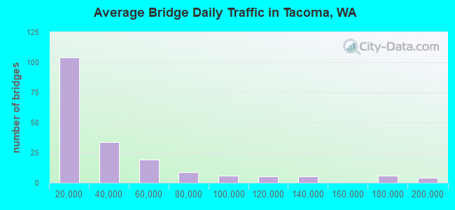
- 6,773,806Total average daily traffic
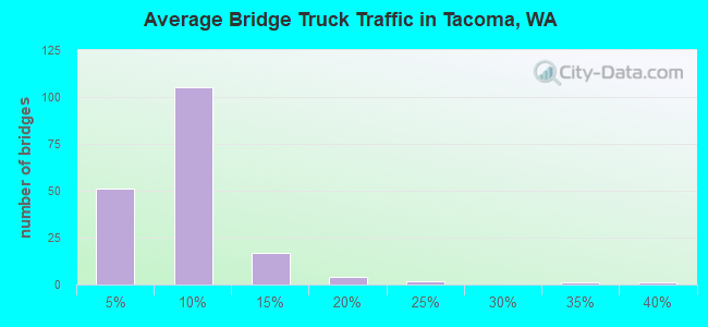
- 486,245Total average daily truck traffic
- National Bridge Inventory (NBI) Registered Bridges for Tacoma
- No street view available for this location
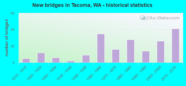
- New bridges - historical statistics
- 51910-1919
- 121920-1929
- 61930-1939
- 21940-1949
- 91950-1959
- 351960-1969
- 161970-1979
- 281980-1989
- 141990-1999
- 262000-2009
- 412010-2019
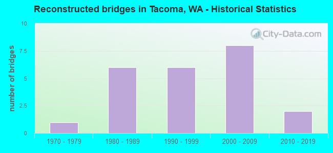
- Reconstructed bridges - Historical Statistics
- 11970-1979
- 61980-1989
- 61990-1999
- 82000-2009
- 22010-2019
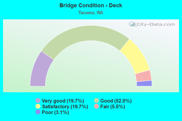
- Bridge Condition - Deck
- 19.7%Very good
- 52.0%Good
- 19.7%Satisfactory
- 5.5%Fair
- 3.1%Poor
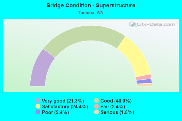
- Bridge Condition - Superstructure
- 21.3%Very good
- 48.0%Good
- 24.4%Satisfactory
- 2.4%Fair
- 2.4%Poor
- 1.6%Serious
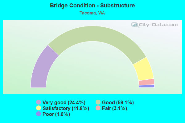
- Bridge Condition - Substructure
- 24.4%Very good
- 59.1%Good
- 11.8%Satisfactory
- 3.1%Fair
- 1.6%Poor
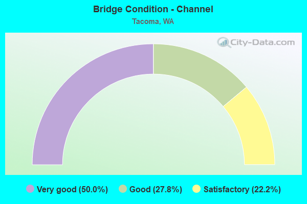
- Bridge Condition - Channel
- 50.0%Very good
- 27.8%Good
- 22.2%Satisfactory
Find on map >> Show street view
Structure Number: 85261, Location: 0.0 INT. JCT I-5 (Lat: 47.213881, Lng: -122.462531), Route carried "on" structure: City street 3210, Year Built: 1970, Status: Open, Structure Length: 6.71m (22.01ft), Average Daily Traffic: 12,145 (year 2021), Truck Traffic: 5%, Average Future Daily Traffic: 21,861 (year 2043), Design Load: HS 20, Features Intersected: INTERSTATE HWY 5, Facility Carried by Structure: SOUTH 48TH STREET
Minimum Vertical Clearance: 30+ m (98+ ft), Kilometerpoint: 0.001, Lanes on structure: 4, Lanes under structure: 6, Owner: City or Municipal Highway Agency, Approaching Roadway Width: 15.2m (49.9ft), Material/Design: Prestressed concrete, Design/Construction: Girder and Floorbeam System, Number Of Spans In Main Unit: 2, Length of Maximum Span: 36.0m (118.1ft), Curb or Sidewalk Widths: Left: 1.4m (4.6ft), Right: 1.4m (4.6ft), Curb-To-Curb Width: 15.2m (49.9ft), Out-to-Out Width: 18.4m (60.4ft)
Condition: Deck: Good, Superstructure: Good, Substructure: Good, Operating Rating: 17.8 metric tons, Method Used To Determine Operating Rating: Load and Resistance Factor Rating (LRFR) rating reported by rating factor(RF) method using HL-93 loadings, Inventory Rating: 13.9 metric tons, Method Used To Determine Inventory Rating: Load and Resistance Factor Rating (LRFR) rating reported by rating factor(RF) method using HL-93 loadings, Structural Evaluation: High priority of corrective action, Deck Geometry: High priority of corrective action, Underclear: Equal to present minimum criteria, Approach Roadway Alignment: Equal to present desirable criteria, Length Of Structure Improvement: 6.71m (22.01ft), Designated Inspection Frequency: Every 24 months, Inspection Date: July 2021, Bridge Improvement Cost: $2,288,000, Roadway Improvement Cost: $458,000, Total Project Cost: $4,576,000 ( Estimate for 2014), Deck Structure Type: Concrete Cast-file-Place, Wearing Surface/Protective System: Wearing Surface: Monolithic Concrete
Find on map >> Show street view
Structure Number: 85284, Location: 0.9 E JCT I-5&38TH (Lat: 47.224708, Lng: -122.482800), Route carried "on" structure: City street 2983, Year Built: 1971, Status: Open, Structure Length: 37.64m (123.49ft), Average Daily Traffic: 19,265 (year 2020), Truck Traffic: 5%, Average Future Daily Traffic: 34,677 (year 2042), Design Load: HS 20, Features Intersected: NPRR &SOUTH TACOMA WAY, Facility Carried by Structure: UNION AVENUE SOUTH
Minimum Vertical Clearance: 30+ m (98+ ft), Kilometerpoint: 16.093, Lanes on structure: 4, Lanes under structure: 4, Base Highway Network: Yes, Owner: City or Municipal Highway Agency, Approaching Roadway Width: 17.1m (56.1ft), Material/Design: Prestressed concrete, Design/Construction: Stringer/Multi-beam, Number Of Spans In Main Unit: 18, Length of Maximum Span: 24.4m (80.1ft), Curb or Sidewalk Widths: Left: 2.0m (6.6ft), Right: 0.0m, Curb-To-Curb Width: 17.1m (56.1ft), Out-to-Out Width: 20.7m (67.9ft)
Condition: Deck: Good, Superstructure: Good, Substructure: Satisfactory, Operating Rating: 55.7 metric tons, Method Used To Determine Operating Rating: Load and Resistance Factor Rating (LRFR) rating reported by rating factor(RF) method using HL-93 loadings, Inventory Rating: 36.3 metric tons, Method Used To Determine Inventory Rating: Load and Resistance Factor Rating (LRFR) rating reported by rating factor(RF) method using HL-93 loadings, Structural Evaluation: Equal to present minimum criteria, Deck Geometry: Somewhat better than minimum adequacy, Underclear: Equal to present minimum criteria, Approach Roadway Alignment: Equal to present desirable criteria, Length Of Structure Improvement: 37.64m (123.49ft), Designated Inspection Frequency: Every 24 months, Inspection Date: August 2020, Bridge Improvement Cost: $14,326,000, Roadway Improvement Cost: $2,865,000, Total Project Cost: $28,652,000 ( Estimate for 2014), Deck Structure Type: Concrete Cast-file-Place, Wearing Surface/Protective System: Wearing Surface: Monolithic Concrete
Find on map >> Show street view
Structure Number: 85445, Location: 2.0 NO JCT I-5 (Lat: 47.249572, Lng: -122.434881), Route carried "on" structure: City street 1280, Year Built: 1986, Status: Open, Structure Length: 12.80m (41.99ft), Average Daily Traffic: 2,631 (year 2020), Average Future Daily Traffic: 4,065 (year 2042), Design Load: HS 20, Features Intersected: DOCK STREET, Facility Carried by Structure: 15TH STREET
Minimum Vertical Clearance: 4.67m (15.32ft), Kilometerpoint: 0.001, Lanes on structure: 2, Lanes under structure: 2, Owner: City or Municipal Highway Agency, Approaching Roadway Width: 11.0m (36.1ft), Material/Design: Concrete continuous, Design/Construction: Box Beam or Girders - Single/Spread, Number Of Spans In Main Unit: 5, Length of Maximum Span: 21.3m (69.9ft), Curb or Sidewalk Widths: Left: 3.0m (9.8ft), Right: 0.0m, Curb-To-Curb Width: 10.4m (34.1ft), Out-to-Out Width: 14.5m (47.6ft)
Condition: Deck: Good, Superstructure: Good, Substructure: Good, Operating Rating: 78.0 metric tons, Method Used To Determine Operating Rating: Load Factor (LF), Inventory Rating: 46.3 metric tons, Method Used To Determine Inventory Rating: Load Factor (LF), Structural Evaluation: Better than present minimum criteria, Deck Geometry: Somewhat better than minimum adequacy, Underclear: Better than present minimum criteria, Approach Roadway Alignment: Equal to present desirable criteria, Length Of Structure Improvement: 12.80m (41.99ft), Designated Inspection Frequency: Every 24 months, Inspection Date: July 2020, Bridge Improvement Cost: $3,192,000, Roadway Improvement Cost: $638,000, Total Project Cost: $6,384,000 ( Estimate for 2014), Deck Structure Type: Concrete Cast-file-Place, Wearing Surface/Protective System: Wearing Surface: Monolithic Concrete, Deck Protection: Epoxy Coated Reinforcing
Find on map >> Show street view
Structure Number: 85446, Location: 3.5 NW JCT I-5 (Lat: 47.277500, Lng: -122.488889), Route carried "on" structure: City street 2979, Year Built: 1927, Year Reconstructed: 2006, Status: Open, Structure Length: 12.10m (39.70ft), Average Daily Traffic: 8,088 (year 2017), Truck Traffic: 5%, Average Future Daily Traffic: 14,558 (year 2039), Design Load: HS 20, Features Intersected: PUGET GULCH N32 TO N 33S, Facility Carried by Structure: NORTH PROCTOR
Minimum Vertical Clearance: 30+ m (98+ ft), Kilometerpoint: 0.001, Lanes on structure: 2, Owner: City or Municipal Highway Agency, Approaching Roadway Width: 14.6m (47.9ft), Material/Design: Concrete, Design/Construction: Arch - Deck, Number Of Spans In Main Unit: 3, Length of Maximum Span: 51.8m (169.9ft), Curb or Sidewalk Widths: Left: 2.0m (6.6ft), Right: 2.0m (6.6ft), Curb-To-Curb Width: 14.0m (45.9ft), Out-to-Out Width: 18.6m (61.0ft)
Condition: Deck: Satisfactory, Superstructure: Satisfactory, Substructure: Satisfactory, Operating Rating: 55.3 metric tons, Method Used To Determine Operating Rating: Load and Resistance Factor (LRFR), Inventory Rating: 32.7 metric tons, Method Used To Determine Inventory Rating: Load and Resistance Factor (LRFR), Structural Evaluation: Equal to present minimum criteria, Deck Geometry: Superior to present desirable criteria, Approach Roadway Alignment: Equal to present desirable criteria, Length Of Structure Improvement: 12.10m (39.70ft), Designated Inspection Frequency: Every 24 months, Inspection Date: May 2020, Bridge Improvement Cost: $3,970,000, Roadway Improvement Cost: $794,000, Total Project Cost: $7,940,000 ( Estimate for 2014), Deck Structure Type: Concrete Cast-file-Place, Wearing Surface/Protective System: Wearing Surface: Bituminous, Membrane: Preformed Fabric
Find on map >> Show street view
Structure Number: 85541, Location: N 21ST & FIFE (Lat: 47.267492, Lng: -122.470950), Route carried "on" structure: City street 3011, Year Built: 1910, Year Reconstructed: 1997, Status: Open, Structure Length: 5.49m (18.01ft), Average Daily Traffic: 15,000 (year 2021), Truck Traffic: 5%, Average Future Daily Traffic: 22,842 (year 2043), Design Load: H 20, Features Intersected: BUCKLEY GULCH, Facility Carried by Structure: NORTH 21ST STREET
Minimum Vertical Clearance: 30+ m (98+ ft), Kilometerpoint: 0.001, Lanes on structure: 2, Base Highway Network: Yes, Owner: City or Municipal Highway Agency, Approaching Roadway Width: 14.6m (47.9ft), Material/Design: Concrete continuous, Design/Construction: Girder and Floorbeam System, Number Of Spans In Main Unit: 3, Length of Maximum Span: 18.3m (60.0ft), Curb or Sidewalk Widths: Left: 1.8m (5.9ft), Right: 1.8m (5.9ft), Curb-To-Curb Width: 14.6m (47.9ft), Out-to-Out Width: 18.3m (60.0ft)
Condition: Deck: Good, Superstructure: Good, Substructure: Good, Operating Rating: 89.8 metric tons, Method Used To Determine Operating Rating: Load Factor (LF), Inventory Rating: 70.7 metric tons, Method Used To Determine Inventory Rating: Load Factor (LF), Structural Evaluation: Better than present minimum criteria, Deck Geometry: Superior to present desirable criteria, Approach Roadway Alignment: Equal to present desirable criteria, Length Of Structure Improvement: 5.79m (19.00ft), Designated Inspection Frequency: Every 24 months, Inspection Date: July 2021, Bridge Improvement Cost: $2,888,000, Roadway Improvement Cost: $578,000, Total Project Cost: $5,776,000 ( Estimate for 2014), Deck Structure Type: Concrete Cast-file-Place, Wearing Surface/Protective System: Wearing Surface: Bituminous
Find on map >> Show street view
Structure Number: 85577, Location: 2.0 N JCT SR509 (Lat: 47.274322, Lng: -122.460111), Route carried "on" structure: City street 3298, Year Built: 1974, Status: Open, Structure Length: 23.77m (77.99ft), Average Daily Traffic: 26,559 (year 2020), Truck Traffic: 5%, Average Future Daily Traffic: 47,806 (year 2042), Design Load: HS 20, Features Intersected: NORTH 30TH & BNRR, Facility Carried by Structure: SCHUSTER PKWY
Minimum Vertical Clearance: 30+ m (98+ ft), Kilometerpoint: 0.001, Lanes on structure: 2, Lanes under structure: 2, Owner: City or Municipal Highway Agency, Approaching Roadway Width: 9.8m (32.2ft), Skew: 9 degrees, Material/Design: Prestressed concrete, Design/Construction: Box Beam or Girders - Single/Spread, Number Of Spans In Main Unit: 7, Length of Maximum Span: 36.6m (120.1ft), Curb-To-Curb Width: 9.8m (32.2ft), Out-to-Out Width: 11.4m (37.4ft)
Condition: Deck: Good, Superstructure: Good, Substructure: Good, Operating Rating: 54.1 metric tons, Method Used To Determine Operating Rating: Load and Resistance Factor Rating (LRFR) rating reported by rating factor(RF) method using HL-93 loadings, Inventory Rating: 41.8 metric tons, Method Used To Determine Inventory Rating: Load and Resistance Factor Rating (LRFR) rating reported by rating factor(RF) method using HL-93 loadings, Structural Evaluation: Better than present minimum criteria, Deck Geometry: Meets minimum limits, Underclear: Somewhat better than minimum adequacy, Approach Roadway Alignment: Equal to present desirable criteria, Length Of Structure Improvement: 23.77m (77.99ft), Designated Inspection Frequency: Every 24 months, Inspection Date: August 2020, Bridge Improvement Cost: $5,304,000, Roadway Improvement Cost: $1,061,000, Total Project Cost: $10,608,000 ( Estimate for 2014), Deck Structure Type: Concrete Cast-file-Place, Wearing Surface/Protective System: Wearing Surface: Monolithic Concrete
Find on map >> Show street view
Structure Number: 85586, Location: 2.0 N JCT I-5 SR73 (Lat: 47.261214, Lng: -122.440150), Route carried "on" structure: Business City street 3017, Year Built: 1987, Status: Open, Structure Length: 15.82m (51.90ft), Average Daily Traffic: 4,000 (year 2021), Truck Traffic: 5%, Average Future Daily Traffic: 5,858 (year 2043), Design Load: HS 20, Features Intersected: DOCK STREET, Facility Carried by Structure: S 4TH STREET
Minimum Vertical Clearance: 30+ m (98+ ft), Kilometerpoint: 0.001, Lanes on structure: 2, Owner: City or Municipal Highway Agency, Approaching Roadway Width: 9.8m (32.2ft), Material/Design: Concrete continuous, Design/Construction: Box Beam or Girders - Multiple, Number Of Spans In Main Unit: 4, Length of Maximum Span: 46.9m (153.9ft), Curb or Sidewalk Widths: Left: 2.4m (7.9ft), Right: 0.0m, Curb-To-Curb Width: 9.8m (32.2ft), Out-to-Out Width: 13.3m (43.6ft)
Condition: Deck: Satisfactory, Superstructure: Good, Substructure: Good, Operating Rating: 78.0 metric tons, Method Used To Determine Operating Rating: Load Factor (LF), Inventory Rating: 46.3 metric tons, Method Used To Determine Inventory Rating: Load Factor (LF), Structural Evaluation: Better than present minimum criteria, Deck Geometry: Meets minimum limits, Underclear: Superior to present desirable criteria, Approach Roadway Alignment: Equal to present desirable criteria, Length Of Structure Improvement: 15.82m (51.90ft), Designated Inspection Frequency: Every 24 months, Inspection Date: August 2021, Bridge Improvement Cost: $3,529,000, Roadway Improvement Cost: $706,000, Total Project Cost: $7,058,000 ( Estimate for 2014), Deck Structure Type: Concrete Cast-file-Place, Wearing Surface/Protective System: Wearing Surface: Monolithic Concrete, Deck Protection: Epoxy Coated Reinforcing
Find on map >> Show street view
Structure Number: 86562, Location: 0.2 N JCT I-5 (Lat: 47.243269, Lng: -122.403250), Route carried "on" structure: City street 3246, Year Built: 1925, Status: Posted for load, Structure Length: 3.57m (11.71ft), Average Daily Traffic: 15,256 (year 2021), Truck Traffic: 5%, Average Future Daily Traffic: 27,461 (year 2042), Design Load: H 20, Features Intersected: RAILROAD, Facility Carried by Structure: Fish War Mem X-ing
Minimum Vertical Clearance: 4.42m (14.50ft), Kilometerpoint: 15.128, Lanes on structure: 3, Base Highway Network: Yes, Owner: City or Municipal Highway Agency, Approaching Roadway Width: 11.0m (36.1ft), Material/Design: Steel, Design/Construction: Truss - Thru, Number Of Spans In Main Unit: 1, Length of Maximum Span: 35.4m (116.1ft), Curb or Sidewalk Widths: Left: 2.4m (7.9ft), Right: 2.4m (7.9ft), Curb-To-Curb Width: 11.1m (36.4ft), Out-to-Out Width: 11.9m (39.0ft)
Condition: Deck: Fair, Superstructure: Serious, Substructure: Satisfactory, Operating Rating: 23.0 metric tons, Method Used To Determine Operating Rating: Load and Resistance Factor Rating (LRFR) rating reported by rating factor(RF) method using HL-93 loadings, Inventory Rating: 17.8 metric tons, Method Used To Determine Inventory Rating: Load and Resistance Factor Rating (LRFR) rating reported by rating factor(RF) method using HL-93 loadings, Structural Evaluation: High priority of corrective action, Deck Geometry: High priority of replacement, Underclear: Superior to present desirable criteria, Approach Roadway Alignment: Equal to present desirable criteria, Bridge Posting: Required (Relationship of Operating Rating to Maximum Legal Load: 10.0 - 19.9% below), Length Of Structure Improvement: 3.87m (12.70ft), Designated Inspection Frequency: Every 12 months, Critical Feature Inspection Frequency: Every 12 months, Inspection Date: June 2021, Critical Feature Inspection Date: June 2021, Bridge Improvement Cost: $2,540,000, Roadway Improvement Cost: $508,000, Total Project Cost: $5,080,000 ( Estimate for 2014), Deck Structure Type: Concrete Cast-file-Place
Find on map >> Show street view
Structure Number: 86565, Location: 0.2 N JCT I-5 (Lat: 47.243208, Lng: -122.403319), Route carried "on" structure: City street 3246, Year Built: 1925, Status: Posted for load, Structure Length: 2.90m (9.51ft), Average Daily Traffic: 15,000 (year 2019), Truck Traffic: 5%, Average Future Daily Traffic: 25,474 (year 2040), Design Load: HS 20, Features Intersected: TERRAIN, Facility Carried by Structure: Fish War Mem X-ing
Minimum Vertical Clearance: 30+ m (98+ ft), Kilometerpoint: 15.096, Lanes on structure: 3, Base Highway Network: Yes, Owner: City or Municipal Highway Agency, Approaching Roadway Width: 11.0m (36.1ft), Skew: 4 degrees, Material/Design: Concrete, Design/Construction: Stringer/Multi-beam, Number Of Spans In Main Unit: 3, Length of Maximum Span: 11.9m (39.0ft), Curb or Sidewalk Widths: Left: 1.5m (4.9ft), Right: 1.5m (4.9ft), Curb-To-Curb Width: 11.0m (36.1ft), Out-to-Out Width: 14.0m (45.9ft)
Condition: Deck: Good, Superstructure: Good, Substructure: Good, Operating Rating: 28.2 metric tons, Method Used To Determine Operating Rating: Load and Resistance Factor Rating (LRFR) rating reported by rating factor(RF) method using HL-93 loadings, Inventory Rating: 21.7 metric tons, Method Used To Determine Inventory Rating: Load and Resistance Factor Rating (LRFR) rating reported by rating factor(RF) method using HL-93 loadings, Structural Evaluation: Somewhat better than minimum adequacy, Deck Geometry: High priority of replacement, Approach Roadway Alignment: Equal to present desirable criteria, Bridge Posting: Required (Relationship of Operating Rating to Maximum Legal Load: 20.0 - 29.9% below), Length Of Structure Improvement: 2.90m (9.51ft), Designated Inspection Frequency: Every 24 months, Inspection Date: June 2020, Bridge Improvement Cost: $722,000, Roadway Improvement Cost: $144,000, Total Project Cost: $1,444,000 ( Estimate for 2014), Deck Structure Type: Concrete Cast-file-Place, Wearing Surface/Protective System: Wearing Surface: Monolithic Concrete
Find on map >> Show street view
Structure Number: 86566, Location: 0.2 N JCT I-5 (Lat: 47.243222, Lng: -122.402053), Route carried "on" structure: City street 3246, Year Built: 1925, Status: Posted for load, Structure Length: 12.71m (41.70ft), Average Daily Traffic: 15,000 (year 2019), Truck Traffic: 5%, Average Future Daily Traffic: 32,000 (year 2040), Design Load: HS 20, Features Intersected: RAMP, Facility Carried by Structure: Fish War Mem X-ing
Minimum Vertical Clearance: 30+ m (98+ ft), Kilometerpoint: 15.160, Lanes on structure: 3, Lanes under structure: 2, Base Highway Network: Yes, Owner: City or Municipal Highway Agency, Approaching Roadway Width: 11.0m (36.1ft), Material/Design: Concrete, Design/Construction: Stringer/Multi-beam, Number Of Spans In Main Unit: 8, Length of Maximum Span: 16.2m (53.1ft), Curb or Sidewalk Widths: Left: 1.5m (4.9ft), Right: 1.5m (4.9ft), Curb-To-Curb Width: 11.0m (36.1ft), Out-to-Out Width: 14.0m (45.9ft)
Condition: Deck: Good, Superstructure: Good, Substructure: Good, Operating Rating: 30.5 metric tons, Method Used To Determine Operating Rating: Load and Resistance Factor Rating (LRFR) rating reported by rating factor(RF) method using HL-93 loadings, Inventory Rating: 23.3 metric tons, Method Used To Determine Inventory Rating: Load and Resistance Factor Rating (LRFR) rating reported by rating factor(RF) method using HL-93 loadings, Structural Evaluation: Somewhat better than minimum adequacy, Deck Geometry: High priority of replacement, Underclear: Meets minimum limits, Approach Roadway Alignment: Equal to present desirable criteria, Length Of Structure Improvement: 13.01m (42.68ft), Designated Inspection Frequency: Every 24 months, Inspection Date: June 2020, Bridge Improvement Cost: $8,540,000, Roadway Improvement Cost: $1,708,000, Total Project Cost: $17,080,000 ( Estimate for 2014), Deck Structure Type: Concrete Cast-file-Place, Wearing Surface/Protective System: Wearing Surface: Monolithic Concrete
Find on map >> Show street view
Structure Number: 8742, Location: East 32nd Street (Lat: 47.235314, Lng: -122.404039), Route carried "on" structure: City street 32, Year Built: 2005, Status: Open, Structure Length: 10.06m (33.01ft), Average Daily Traffic: 2,200 (year 2020), Average Future Daily Traffic: 3,500 (year 2042), Design Load: HS 25 or greater, Features Intersected: Lister Gulch
Minimum Vertical Clearance: 30+ m (98+ ft), Kilometerpoint: 0.001, Lanes on structure: 2, Owner: City or Municipal Highway Agency, Approaching Roadway Width: 14.6m (47.9ft), Material/Design: Prestressed concrete, Design/Construction: Stringer/Multi-beam, Number Of Spans In Main Unit: 3, Length of Maximum Span: 47.5m (155.8ft), Curb or Sidewalk Widths: Left: 2.4m (7.9ft), Right: 2.4m (7.9ft), Curb-To-Curb Width: 14.6m (47.9ft), Out-to-Out Width: 20.1m (65.9ft)
Condition: Deck: Good, Superstructure: Very good, Substructure: Very good, Operating Rating: 64.4 metric tons, Method Used To Determine Operating Rating: Load and Resistance Factor (LRFR), Inventory Rating: 39.0 metric tons, Method Used To Determine Inventory Rating: Load and Resistance Factor (LRFR), Structural Evaluation: Equal to present desirable criteria, Deck Geometry: Superior to present desirable criteria, Approach Roadway Alignment: Equal to present desirable criteria, Length Of Structure Improvement: 10.06m (33.01ft), Designated Inspection Frequency: Every 24 months, Inspection Date: May 2020, Bridge Improvement Cost: $3,300,000, Roadway Improvement Cost: $660,000, Total Project Cost: $6,600,000 ( Estimate for 2014), Deck Structure Type: Concrete Cast-file-Place, Wearing Surface/Protective System: Wearing Surface: Monolithic Concrete, Deck Protection: Epoxy Coated Reinforcing
Find on map >> Show street view
Structure Number: 8814, Location: Puyallup River Crossing (Lat: 47.260556, Lng: -122.419722), Route carried "on" structure: City street 50950, Year Built: 1930, Status: Closed, Structure Length: 66.48m (218.11ft), Features Intersected: Milwaukee Way, Facility Carried by Structure: East 11th Street
Minimum Vertical Clearance: 30+ m (98+ ft), Kilometerpoint: 0.001, Lanes on structure: 2, Lanes under structure: 7, Owner: City or Municipal Highway Agency, Approaching Roadway Width: 19.5m (64.0ft), Material/Design: Steel, Design/Construction: Girder and Floorbeam System, Number Of Spans In Main Unit: 49, Number Of Approach Spans: 10, Length of Maximum Span: 49.1m (161.1ft), Curb or Sidewalk Widths: Left: 1.8m (5.9ft), Right: 1.8m (5.9ft), Curb-To-Curb Width: 12.2m (40.0ft), Out-to-Out Width: 15.8m (51.8ft)
Condition: Deck: Poor, Superstructure: Poor, Substructure: Fair, Deck Geometry: Superior to present desirable criteria, Approach Roadway Alignment: Equal to present desirable criteria, Length Of Structure Improvement: 66.48m (218.11ft), Designated Inspection Frequency: Every 24 months, Inspection Date: December 2019, Bridge Improvement Cost: $28,789,000, Roadway Improvement Cost: $5,758,000, Total Project Cost: $57,578,000 ( Estimate for 2014), Deck Structure Type: Concrete Cast-file-Place, Wearing Surface/Protective System: Wearing Surface: Monolithic Concrete
Find on map >> Show street view
Structure Number: 88226, Location: 0.1 N JCT I-5 (Lat: 47.240778, Lng: -122.417211), Route carried "on" structure: City street 3129, Year Built: 2007, Status: Open, Structure Length: 5.79m (19.00ft), Average Daily Traffic: 1,521 (year 2021), Truck Traffic: 5%, Average Future Daily Traffic: 2,350 (year 2043), Design Load: HS 25 or greater, Features Intersected: EAST 25TH STREET, Facility Carried by Structure: EAST L STREET
Minimum Vertical Clearance: 30+ m (98+ ft), Kilometerpoint: 0.001, Lanes on structure: 2, Lanes under structure: 2, Owner: City or Municipal Highway Agency, Approaching Roadway Width: 9.8m (32.2ft), Material/Design: Prestressed concrete, Design/Construction: Tee Beam, Number Of Spans In Main Unit: 2, Length of Maximum Span: 27.4m (89.9ft), Curb or Sidewalk Widths: Left: 1.5m (4.9ft), Right: 1.5m (4.9ft), Curb-To-Curb Width: 9.8m (32.2ft), Out-to-Out Width: 13.4m (44.0ft)
Condition: Deck: Very good, Superstructure: Very good, Substructure: Very good, Operating Rating: 87.1 metric tons, Method Used To Determine Operating Rating: Load and Resistance Factor (LRFR), Inventory Rating: 51.7 metric tons, Method Used To Determine Inventory Rating: Load and Resistance Factor (LRFR), Structural Evaluation: Equal to present desirable criteria, Deck Geometry: Somewhat better than minimum adequacy, Underclear: Equal to present desirable criteria, Approach Roadway Alignment: Equal to present desirable criteria, Length Of Structure Improvement: 5.79m (19.00ft), Designated Inspection Frequency: Every 24 months, Inspection Date: August 2021, Bridge Improvement Cost: $1,292,000, Roadway Improvement Cost: $258,000, Total Project Cost: $2,584,000 ( Estimate for 2014), Deck Structure Type: Concrete Cast-file-Place, Wearing Surface/Protective System: Wearing Surface: Monolithic Concrete, Deck Protection: Epoxy Coated Reinforcing
Find on map >> Show street view
Structure Number: 88268, Location: East D St. (Lat: 47.241483, Lng: -122.429667), Route carried "on" structure: City street 3101, Year Built: 2008, Status: Open, Structure Length: 6.43m (21.10ft), Average Daily Traffic: 4,000 (year 2020), Truck Traffic: 5%, Average Future Daily Traffic: 4,880 (year 2042), Design Load: HS 20, Features Intersected: Railroad, Facility Carried by Structure: D Street
Minimum Vertical Clearance: 30+ m (98+ ft), Kilometerpoint: 0.001, Lanes on structure: 3, Owner: City or Municipal Highway Agency, Approaching Roadway Width: 13.7m (44.9ft), Skew: 1 degrees, Material/Design: Prestressed concrete, Design/Construction: Stringer/Multi-beam, Number Of Spans In Main Unit: 2, Length of Maximum Span: 33.5m (109.9ft), Curb or Sidewalk Widths: Left: 3.0m (9.8ft), Right: 3.0m (9.8ft), Curb-To-Curb Width: 17.1m (56.1ft), Out-to-Out Width: 23.2m (76.1ft)
Condition: Deck: Good, Superstructure: Very good, Substructure: Very good, Operating Rating: 68.9 metric tons, Method Used To Determine Operating Rating: Load Testing, Inventory Rating: 40.8 metric tons, Method Used To Determine Inventory Rating: Load Testing, Structural Evaluation: Equal to present desirable criteria, Deck Geometry: Superior to present desirable criteria, Underclear: Equal to present minimum criteria, Approach Roadway Alignment: Equal to present desirable criteria, Length Of Structure Improvement: 6.43m (21.10ft), Designated Inspection Frequency: Every 24 months, Inspection Date: July 2020, Bridge Improvement Cost: $1,984,000, Roadway Improvement Cost: $397,000, Total Project Cost: $3,967,000 ( Estimate for 2014), Deck Structure Type: Concrete Cast-file-Place, Wearing Surface/Protective System: Wearing Surface: Monolithic Concrete, Deck Protection: Epoxy Coated Reinforcing
Find on map >> Show street view
Structure Number: 88378, Location: 0.6 NE JCT E Portland Ave (Lat: 47.253653, Lng: -122.408089), Route carried "on" structure: City street 1280, Year Built: 2011, Status: Open, Structure Length: 35.20m (115.49ft), Average Daily Traffic: 7,100 (year 2021), Truck Traffic: 30%, Average Future Daily Traffic: 12,120 (year 2043), Design Load: HL 93, Features Intersected: E Marc St, Milwaukee Way, Facility Carried by Structure: Lincoln Ave
Minimum Vertical Clearance: 30+ m (98+ ft), Kilometerpoint: 0.001, Lanes on structure: 2, Lanes under structure: 7, Owner: City or Municipal Highway Agency, Approaching Roadway Width: 12.5m (41.0ft), Skew: 2 degrees, Material/Design: Prestressed concrete continuous, Design/Construction: Stringer/Multi-beam, Number Of Spans In Main Unit: 7, Length of Maximum Span: 50.3m (165.0ft), Curb or Sidewalk Widths: Left: 1.8m (5.9ft), Right: 0.0m, Curb-To-Curb Width: 12.5m (41.0ft), Out-to-Out Width: 14.9m (48.9ft)
Condition: Deck: Very good, Superstructure: Very good, Substructure: Very good, Operating Rating: 65.3 metric tons, Method Used To Determine Operating Rating: Load and Resistance Factor (LRFR), Inventory Rating: 39.0 metric tons, Method Used To Determine Inventory Rating: Load and Resistance Factor (LRFR), Structural Evaluation: Equal to present desirable criteria, Deck Geometry: Somewhat better than minimum adequacy, Underclear: Superior to present desirable criteria, Approach Roadway Alignment: Equal to present desirable criteria, Length Of Structure Improvement: 35.51m (116.50ft), Designated Inspection Frequency: Every 24 months, Inspection Date: June 2021, Bridge Improvement Cost: $17,708,000, Roadway Improvement Cost: $3,542,000, Total Project Cost: $35,416,000 ( Estimate for 2014), Deck Structure Type: Concrete Cast-file-Place, Wearing Surface/Protective System: Wearing Surface: Monolithic Concrete, Deck Protection: Epoxy Coated Reinforcing
Find on map >> Show street view
Structure Number: 88379, Location: S atThorne & Lincoln (Lat: 47.257806, Lng: -122.402297), Route carried "on" structure: Business Other road 1280, Year Built: 2011, Status: Open, Structure Length: 1.74m (5.71ft), Average Daily Traffic: 1,000 (year 2021), Truck Traffic: 1%, Average Future Daily Traffic: 1,200 (year 2043), Design Load: HL 93, Features Intersected: Lincoln Avenue ditch, Facility Carried by Structure: Port Auto Access
Minimum Vertical Clearance: 30+ m (98+ ft), Kilometerpoint: 0.001, Lanes on structure: 2, Owner: City or Municipal Highway Agency, Approaching Roadway Width: 9.1m (29.9ft), Skew: 1 degrees, Material/Design: Prestressed concrete continuous, Design/Construction: Slab, Number Of Spans In Main Unit: 1, Length of Maximum Span: 14.3m (46.9ft), Curb-To-Curb Width: 12.9m (42.3ft), Out-to-Out Width: 13.9m (45.6ft)
Condition: Deck: Very good, Superstructure: Very good, Substructure: Very good, Operating Rating: 65.3 metric tons, Method Used To Determine Operating Rating: Load and Resistance Factor (LRFR), Inventory Rating: 39.0 metric tons, Method Used To Determine Inventory Rating: Load and Resistance Factor (LRFR), Structural Evaluation: Equal to present desirable criteria, Deck Geometry: Superior to present desirable criteria, Approach Roadway Alignment: Equal to present desirable criteria, Length Of Structure Improvement: 2.04m (6.69ft), Designated Inspection Frequency: Every 24 months, Inspection Date: June 2021, Bridge Improvement Cost: $1,018,000, Roadway Improvement Cost: $204,000, Total Project Cost: $2,037,000 ( Estimate for 2014), Deck Structure Type: Concrete Cast-file-Place, Wearing Surface/Protective System: Wearing Surface: Monolithic Concrete, Deck Protection: Epoxy Coated Reinforcing
Find on map >> Show street view
Structure Number: 88852, Location: 1.0 N JCT SR 509 (Lat: 47.257894, Lng: -122.439150), Route carried "on" structure: City street 3298, Year Built: 1974, Status: Open, Structure Length: 18.99m (62.30ft), Average Daily Traffic: 7,955 (year 2019), Truck Traffic: 5%, Average Future Daily Traffic: 14,319 (year 2041), Design Load: HS 20, Features Intersected: SCHUSTER PKWY NB, Facility Carried by Structure: TAC SPUR-SCHUST SB
Minimum Vertical Clearance: 4.67m (15.32ft), Kilometerpoint: 9.656, Lanes on structure: 1, Lanes under structure: 1, Base Highway Network: Yes, Owner: City or Municipal Highway Agency, Approaching Roadway Width: 7.6m (24.9ft), Skew: 1 degrees, Material/Design: Prestressed concrete, Design/Construction: Stringer/Multi-beam, Number Of Spans In Main Unit: 6, Length of Maximum Span: 36.0m (118.1ft), Curb-To-Curb Width: 5.5m (18.0ft), Out-to-Out Width: 6.2m (20.3ft)
Condition: Deck: Satisfactory, Superstructure: Satisfactory, Substructure: Satisfactory, Operating Rating: 79.8 metric tons, Method Used To Determine Operating Rating: Load and Resistance Factor (LRFR), Inventory Rating: 48.1 metric tons, Method Used To Determine Inventory Rating: Load and Resistance Factor (LRFR), Structural Evaluation: Equal to present minimum criteria, Deck Geometry: High priority of replacement, Underclear: High priority of corrective action, Approach Roadway Alignment: Equal to present minimum criteria, Length Of Structure Improvement: 18.99m (62.30ft), Designated Inspection Frequency: Every 24 months, Inspection Date: October 2020, Bridge Improvement Cost: $3,364,000, Roadway Improvement Cost: $673,000, Total Project Cost: $6,728,000 ( Estimate for 2014), Deck Structure Type: Concrete Cast-file-Place, Wearing Surface/Protective System: Wearing Surface: Monolithic Concrete
Find on map >> Show street view
Structure Number: 88853, Location: 1.0 N JCT SR 509 (Lat: 47.257183, Lng: -122.438094), Route carried "on" structure: City street 3298, Year Built: 1974, Status: Open, Structure Length: 21.95m (72.01ft), Average Daily Traffic: 8,125 (year 2019), Truck Traffic: 5%, Average Future Daily Traffic: 14,625 (year 2041), Design Load: HS 20, Features Intersected: SCHUSTER PKWY SB, Facility Carried by Structure: TAC SPUR-SCHUST SB
Minimum Vertical Clearance: 4.88m (16.01ft), Kilometerpoint: 9.656, Lanes on structure: 1, Base Highway Network: Yes, Owner: City or Municipal Highway Agency, Approaching Roadway Width: 4.3m (14.1ft), Material/Design: Prestressed concrete, Design/Construction: Stringer/Multi-beam, Number Of Spans In Main Unit: 7, Length of Maximum Span: 36.0m (118.1ft), Curb-To-Curb Width: 5.5m (18.0ft), Out-to-Out Width: 6.2m (20.3ft)
Condition: Deck: Satisfactory, Superstructure: Satisfactory, Substructure: Satisfactory, Operating Rating: 79.8 metric tons, Method Used To Determine Operating Rating: Load and Resistance Factor (LRFR), Inventory Rating: 48.1 metric tons, Method Used To Determine Inventory Rating: Load and Resistance Factor (LRFR), Structural Evaluation: Equal to present minimum criteria, Deck Geometry: High priority of replacement, Approach Roadway Alignment: Equal to present minimum criteria, Length Of Structure Improvement: 21.95m (72.01ft), Designated Inspection Frequency: Every 24 months, Inspection Date: October 2020, Bridge Improvement Cost: $2,304,000, Roadway Improvement Cost: $461,000, Total Project Cost: $4,608,000 ( Estimate for 2014), Deck Structure Type: Concrete Cast-file-Place, Wearing Surface/Protective System: Wearing Surface: Monolithic Concrete
Find on map >> Show street view
Structure Number: 88854, Location: 1.0 N JCT SR 509 (Lat: 47.257214, Lng: -122.438022), Route carried "on" structure: City street 3298, Year Built: 1974, Status: Open, Structure Length: 27.49m (90.19ft), Average Daily Traffic: 11,151 (year 2020), Truck Traffic: 5%, Average Future Daily Traffic: 14,800 (year 2042), Design Load: HS 20, Features Intersected: SCHUSTER PARKWAY, Facility Carried by Structure: TAC SPUR-STADIUM N
Minimum Vertical Clearance: 30+ m (98+ ft), Kilometerpoint: 9.656, Lanes on structure: 1, Lanes under structure: 4, Base Highway Network: Yes, Owner: City or Municipal Highway Agency, Approaching Roadway Width: 4.6m (15.1ft), Skew: 1 degrees, Material/Design: Prestressed concrete, Design/Construction: Stringer/Multi-beam, Number Of Spans In Main Unit: 10, Length of Maximum Span: 36.0m (118.1ft), Curb-To-Curb Width: 4.6m (15.1ft), Out-to-Out Width: 7.1m (23.3ft)
Condition: Deck: Fair, Superstructure: Satisfactory, Substructure: Satisfactory, Operating Rating: 79.8 metric tons, Method Used To Determine Operating Rating: Load and Resistance Factor (LRFR), Inventory Rating: 48.1 metric tons, Method Used To Determine Inventory Rating: Load and Resistance Factor (LRFR), Structural Evaluation: Equal to present minimum criteria, Deck Geometry: High priority of replacement, Underclear: High priority of corrective action, Approach Roadway Alignment: Equal to present minimum criteria, Length Of Structure Improvement: 27.49m (90.19ft), Designated Inspection Frequency: Every 24 months, Inspection Date: October 2020, Bridge Improvement Cost: $3,067,000, Roadway Improvement Cost: $613,000, Total Project Cost: $6,134,000 ( Estimate for 2014), Deck Structure Type: Concrete Cast-file-Place, Wearing Surface/Protective System: Wearing Surface: Monolithic Concrete
Find on map >> Show street view
Structure Number: 89074, Location: 0.01 E JCT PORTLAND AVE (Lat: 47.242631, Lng: -122.410722), Route carried "on" structure: City street 3246, Year Built: 2019, Status: Posted for load, Structure Length: 31.18m (102.30ft), Average Daily Traffic: 16,500 (year 2021), Truck Traffic: 5%, Average Future Daily Traffic: 25,500 (year 2043), Design Load: HL 93, Features Intersected: RAMP, RR, ROAD, TERRAIN, Facility Carried by Structure: FISHING WARS XING
Minimum Vertical Clearance: 30+ m (98+ ft), Kilometerpoint: 0.001, Lanes on structure: 3, Lanes under structure: 1, Base Highway Network: Yes, Owner: City or Municipal Highway Agency, Approaching Roadway Width: 20.7m (67.9ft), Skew: 9 degrees, Material/Design: Prestressed concrete continuous, Design/Construction: Stringer/Multi-beam, Number Of Spans In Main Unit: 9, Length of Maximum Span: 35.1m (115.2ft), Curb or Sidewalk Widths: Left: 1.5m (4.9ft), Right: 1.5m (4.9ft), Curb-To-Curb Width: 11.3m (37.1ft), Out-to-Out Width: 20.1m (65.9ft)
Condition: Deck: Very good, Superstructure: Very good, Substructure: Very good, Operating Rating: 44.7 metric tons, Method Used To Determine Operating Rating: Load and Resistance Factor Rating (LRFR) rating reported by rating factor(RF) method using HL-93 loadings, Inventory Rating: 34.7 metric tons, Method Used To Determine Inventory Rating: Load and Resistance Factor Rating (LRFR) rating reported by rating factor(RF) method using HL-93 loadings, Structural Evaluation: Equal to present desirable criteria, Deck Geometry: High priority of replacement, Underclear: Superior to present desirable criteria, Approach Roadway Alignment: Equal to present desirable criteria, Length Of Structure Improvement: 31.18m (102.30ft), Designated Inspection Frequency: Every 24 months, Inspection Date: September 2021, Bridge Improvement Cost: $14,322,000, Roadway Improvement Cost: $2,864,000, Total Project Cost: $28,644,000 ( Estimate for 2014), Deck Structure Type: Concrete Cast-file-Place, Wearing Surface/Protective System: Wearing Surface: Monolithic Concrete, Deck Protection: Epoxy Coated Reinforcing
Find on map >> Show street view
Structure Number: 89146, Location: 1.9 N JCT I-705 (Lat: 47.249331, Lng: -122.385650), Route carried "on" structure: City street 509, Year Built: 2001, Status: Open, Structure Length: 1.83m (6.00ft), Average Daily Traffic: 13,900 (year 2020), Truck Traffic: 15%, Average Future Daily Traffic: 15,000 (year 2038), Design Load: HL 93, Features Intersected: Port Access Road, Facility Carried by Structure: Port of Tacoma Rd
Minimum Vertical Clearance: 30+ m (98+ ft), Kilometerpoint: 3.798, Lanes on structure: 4, Lanes under structure: 2, Base Highway Network: Yes, Owner: City or Municipal Highway Agency, Approaching Roadway Width: 18.0m (59.1ft), Skew: 20 degrees, Material/Design: Steel, Design/Construction: Culvert, Number Of Spans In Main Unit: 2, Length of Maximum Span: 6.4m (21.0ft), Curb or Sidewalk Widths: Left: 1.8m (5.9ft), Right: 1.8m (5.9ft), Curb-To-Curb Width: 18.3m (60.0ft), Out-to-Out Width: 21.9m (71.9ft)
Condition: Culverts: Good, Operating Rating: 96.9 metric tons, Method Used To Determine Operating Rating: Load and Resistance Factor Rating (LRFR) rating reported by rating factor(RF) method using HL-93 loadings, Inventory Rating: 96.9 metric tons, Method Used To Determine Inventory Rating: Load and Resistance Factor Rating (LRFR) rating reported by rating factor(RF) method using HL-93 loadings, Structural Evaluation: Better than present minimum criteria, Deck Geometry: Somewhat better than minimum adequacy, Underclear: High priority of replacement, Approach Roadway Alignment: Equal to present desirable criteria, Length Of Structure Improvement: 2.13m (6.99ft), Designated Inspection Frequency: Every 24 months, Inspection Date: April 2020, Bridge Improvement Cost: $1,736,000, Roadway Improvement Cost: $347,000, Total Project Cost: $3,472,000 ( Estimate for 2014), Wearing Surface/Protective System: Wearing Surface: Monolithic Concrete
Find on map >> Show street view
Structure Number: 5452A, Location: 0.3 N JCT I-5 (Lat: 47.253956, Lng: -122.433075), Route carried "under" structure: Interstate 705, Year Built: 1911, Structure Length: 0. m, Average Daily Traffic: 40,311 (year 2019), Truck Traffic: 3%, Features Intersected: CITY WATERWAY CS2749, Facility Carried by Structure: E 11TH ST
Minimum Vertical Clearance: 11.20m (36.75ft), Kilometerpoint: 2.317, Lanes on structure: 2, Lanes under structure: 4, Material/Design: Steel, Design/Construction: Movable - Lift, Length of Maximum Span: 67.4m (221.1ft)
Find on map >> Show street view
Structure Number: 5667C, Location: 1.4 N JCT SR 512 (Lat: 47.181067, Lng: -122.465219), Route carried "under" structure: Interstate 5, Year Built: 1958, Structure Length: 0. m, Average Daily Traffic: 170,806 (year 2019), Truck Traffic: 11%, Features Intersected: I-5, Facility Carried by Structure: S 84TH ST
Minimum Vertical Clearance: 5.11m (16.77ft), Kilometerpoint: 207.477, Lanes on structure: 4, Lanes under structure: 8, Material/Design: Concrete continuous, Design/Construction: Slab, Length of Maximum Span: 21.0m (68.9ft)
Find on map >> Show street view
Structure Number: 5723A, Location: 2.1 N JCT SR 512 (Lat: 47.190608, Lng: -122.462736), Route carried "under" structure: Interstate 5, Year Built: 1958, Structure Length: 0. m, Average Daily Traffic: 162,174 (year 2019), Truck Traffic: 11%, Features Intersected: I-5, Facility Carried by Structure: S 74TH - S 72ND ST
Minimum Vertical Clearance: 5.89m (19.32ft), Kilometerpoint: 208.555, Lanes on structure: 8, Lanes under structure: 8, Material/Design: Concrete continuous, Design/Construction: Box Beam or Girders - Multiple, Length of Maximum Span: 27.1m (88.9ft)
Find on map >> Show street view
Structure Number: 5831A, Location: 3.2 N JCT SR 512 (Lat: 47.206583, Lng: -122.462056), Route carried "under" structure: Interstate 5, Year Built: 1958, Structure Length: 0. m, Average Daily Traffic: 181,111 (year 2019), Truck Traffic: 11%, Features Intersected: I-5
Minimum Vertical Clearance: 5.16m (16.93ft), Kilometerpoint: 210.325, Lanes on structure: 6, Lanes under structure: 10, Material/Design: Concrete continuous, Design/Construction: Slab, Length of Maximum Span: 17.4m (57.1ft)
Find on map >> Show street view
Structure Number: 6613B, Location: JCT I-5 (Lat: 47.239972, Lng: -122.402917), Route carried "under" structure: State highway 167, Year Built: 1962, Structure Length: 0. m, Average Daily Traffic: 23,913 (year 2019), Truck Traffic: 6%, Features Intersected: PUYALLUP R/RR/SR 167, Facility Carried by Structure: I-5
Minimum Vertical Clearance: 6.32m (20.73ft), Kilometerpoint: 0.451, Lanes on structure: 5, Lanes under structure: 4, Material/Design: Prestressed concrete, Design/Construction: Stringer/Multi-beam, Length of Maximum Span: 30.8m (101.0ft)
Find on map >> Show street view
Structure Number: 6821A, Location: JCT I-5 (Lat: 47.239556, Lng: -122.407694), Route carried "under" structure: State highway 167, Year Built: 1962, Structure Length: 0. m, Average Daily Traffic: 4,325 (year 2019), Truck Traffic: 6%, Features Intersected: SR 167 NB, Facility Carried by Structure: I-5
Minimum Vertical Clearance: 5.26m (17.26ft), Kilometerpoint: 0.001, Lanes on structure: 11, Lanes under structure: 2, Material/Design: Prestressed concrete, Design/Construction: Stringer/Multi-beam, Length of Maximum Span: 14.9m (48.9ft)
Find on map >> Show street view
Structure Number: 6979E, Location: JCT I-5 (Lat: 47.239992, Lng: -122.404186), Route carried "under" structure: Ramp State highway 167, Year Built: 1963, Structure Length: 0. m, Average Daily Traffic: 12,184 (year 2012), Truck Traffic: 10%, Features Intersected: SR 167 RAMP TO SB I-5
Minimum Vertical Clearance: 5.11m (16.77ft), Kilometerpoint: 0.177, Lanes on structure: 1, Lanes under structure: 1, Material/Design: Concrete continuous, Design/Construction: Box Beam or Girders - Multiple, Length of Maximum Span: 21.9m (71.9ft)
Find on map >> Show street view
Structure Number: 7326A, Location: 1.4 N JCT SR 16 (Lat: 47.233139, Lng: -122.433778), Route carried "under" structure: Ramp Interstate 5, Year Built: 1964, Structure Length: 0. m, Average Daily Traffic: 19,637 (year 2012), Truck Traffic: 3%, Features Intersected: I-705, SR 7, RAMPS, RR
Minimum Vertical Clearance: 7.01m (23.00ft), Kilometerpoint: 0.257, Lanes on structure: 2, Lanes under structure: 8, Material/Design: Concrete continuous, Design/Construction: Box Beam or Girders - Multiple, Length of Maximum Span: 30.5m (100.1ft)
Find on map >> Show street view
Structure Number: 7326A, Location: JCT I-5 (Lat: 47.233139, Lng: -122.433778), Route carried "under" structure: Ramp Interstate 7, Year Built: 1964, Structure Length: 0. m, Average Daily Traffic: 14,969 (year 2019), Truck Traffic: 4%, Features Intersected: I-705, SR 7, RAMPS, RR, Facility Carried by Structure: I-5 HOV
Minimum Vertical Clearance: 6.81m (22.34ft), Kilometerpoint: 94.308, Lanes on structure: 2, Lanes under structure: 8, Material/Design: Concrete continuous, Design/Construction: Box Beam or Girders - Multiple, Length of Maximum Span: 30.5m (100.1ft)
Find on map >> Show street view
Structure Number: 7326B, Location: 1.4 N JCT SR 16 (Lat: 47.233278, Lng: -122.434000), Route carried "under" structure: Ramp Interstate 5, Year Built: 1964, Structure Length: 0. m, Average Daily Traffic: 19,637 (year 2012), Truck Traffic: 3%, Features Intersected: I-705, SR 7, RAMPS, RR
Minimum Vertical Clearance: 8.03m (26.35ft), Kilometerpoint: 0.290, Lanes on structure: 4, Lanes under structure: 8, Material/Design: Concrete continuous, Design/Construction: Box Beam or Girders - Multiple, Length of Maximum Span: 29.6m (97.1ft)
Find on map >> Show street view
Structure Number: 7326B, Location: JCT I-5 (Lat: 47.233278, Lng: -122.434000), Route carried "under" structure: State highway 7, Year Built: 1964, Structure Length: 0. m, Average Daily Traffic: 14,969 (year 2019), Truck Traffic: 4%, Features Intersected: I-705, SR 7, RAMPS, RR, Facility Carried by Structure: I-5
Minimum Vertical Clearance: 7.59m (24.90ft), Kilometerpoint: 0.032, Lanes on structure: 4, Lanes under structure: 8, Material/Design: Concrete continuous, Design/Construction: Box Beam or Girders - Multiple, Length of Maximum Span: 29.6m (97.1ft)
Find on map >> Show street view
Structure Number: 7326C, Location: 6.1 N JCT SR 512 (Lat: 47.232778, Lng: -122.433139), Route carried "under" structure: Ramp State highway 7, Year Built: 1964, Structure Length: 0. m, Average Daily Traffic: 3,367 (year 2012), Truck Traffic: 5%, Features Intersected: S-S RAMP I-705 TO SR 7, Facility Carried by Structure: I-5
Minimum Vertical Clearance: 5.28m (17.32ft), Kilometerpoint: 0.274, Lanes on structure: 2, Lanes under structure: 4, Material/Design: Concrete continuous, Design/Construction: Box Beam or Girders - Multiple, Length of Maximum Span: 25.9m (85.0ft)
Find on map >> Show street view
Structure Number: 7326D, Location: 5.5 N JCT SR 512 (Lat: 47.233161, Lng: -122.431917), Route carried "under" structure: Ramp State highway 705, Year Built: 1965, Structure Length: 0. m, Average Daily Traffic: 14,969 (year 2019), Truck Traffic: 4%, Features Intersected: S-S RAMP I-705 TO SR 7, Facility Carried by Structure: I-5
Minimum Vertical Clearance: 5.77m (18.93ft), Kilometerpoint: 94.211, Lanes on structure: 1, Lanes under structure: 4, Material/Design: Concrete continuous, Design/Construction: Box Beam or Girders - Multiple, Length of Maximum Span: 32.0m (105.0ft)
Find on map >> Show street view
Structure Number: 7326E, Location: 5.6 N JCT SR 512 (Lat: 47.232750, Lng: -122.433000), Route carried "under" structure: State highway 7, Year Built: 1965, Structure Length: 0. m, Average Daily Traffic: 14,969 (year 2019), Truck Traffic: 4%, Features Intersected: SR 7 SB
Minimum Vertical Clearance: 4.98m (16.34ft), Kilometerpoint: 94.227, Lanes on structure: 1, Lanes under structure: 4, Material/Design: Concrete continuous, Design/Construction: Box Beam or Girders - Multiple, Length of Maximum Span: 25.9m (85.0ft)
Find on map >> Show street view
Structure Number: 7505D, Location: 1.4 N JCT SR 16 (Lat: 47.229861, Lng: -122.428611), Route carried "under" structure: Ramp Interstate 5, Year Built: 1966, Structure Length: 0. m, Average Daily Traffic: 4,393 (year 2012), Truck Traffic: 15%, Features Intersected: SR 7 SB, RAILROAD, Facility Carried by Structure: SR 7 NB
Minimum Vertical Clearance: 5.46m (17.91ft), Kilometerpoint: 0.660, Lanes on structure: 3, Lanes under structure: 3, Material/Design: Concrete continuous, Design/Construction: Box Beam or Girders - Multiple, Length of Maximum Span: 44.5m (146.0ft)
Find on map >> Show street view
Structure Number: 7505E, Location: 1.4 N JCT SR 16 (Lat: 47.234028, Lng: -122.435472), Route carried "under" structure: Ramp Interstate 5, Year Built: 1965, Structure Length: 0. m, Average Daily Traffic: 3,718 (year 2012), Truck Traffic: 5%, Features Intersected: S-S RAMP, Facility Carried by Structure: S 30TH ST
Minimum Vertical Clearance: 6.55m (21.49ft), Kilometerpoint: 0.225, Lanes on structure: 2, Lanes under structure: 1, Material/Design: Concrete continuous, Design/Construction: Box Beam or Girders - Multiple, Length of Maximum Span: 25.0m (82.0ft)
Find on map >> Show street view
Structure Number: 8006A, Location: 4.9 N JCT SR 512 (Lat: 47.223114, Lng: -122.427139), Route carried "under" structure: State highway 7, Year Built: 1967, Structure Length: 0. m, Average Daily Traffic: 14,145 (year 2019), Truck Traffic: 4%, Features Intersected: SR 7, Facility Carried by Structure: E 38TH STEET
Minimum Vertical Clearance: 9.12m (29.92ft), Kilometerpoint: 92.988, Lanes on structure: 5, Lanes under structure: 2, Material/Design: Prestressed concrete continuous, Design/Construction: Stringer/Multi-beam, Length of Maximum Span: 27.1m (88.9ft)
Find on map >> Show street view
Structure Number: 8543C, Location: 0.4 N JCT I-5 (Lat: 47.236639, Lng: -122.463583), Route carried "under" structure: Ramp State highway 16, Year Built: 1969, Structure Length: 0. m, Average Daily Traffic: 29,693 (year 2012), Truck Traffic: 8%, Features Intersected: SR 16 RAMPS/S SPRAGUE AV, Facility Carried by Structure: S 25TH ST
Minimum Vertical Clearance: 5.54m (18.18ft), Kilometerpoint: 0.386, Lanes on structure: 2, Lanes under structure: 4, Material/Design: Prestressed concrete continuous, Design/Construction: Stringer/Multi-beam, Length of Maximum Span: 30.2m (99.1ft)
Find on map >> Show street view
Structure Number: 12245A, Location: JCT SR 16 (Lat: 47.256917, Lng: -122.515528), Route carried "under" structure: State highway 163, Year Built: 1983, Structure Length: 0. m, Average Daily Traffic: 20,005 (year 2019), Truck Traffic: 3%, Features Intersected: SR 163/PEARL ST, Facility Carried by Structure: SR 16
Minimum Vertical Clearance: 5.92m (19.42ft), Kilometerpoint: 0.001, Lanes on structure: 3, Lanes under structure: 5, Material/Design: Prestressed concrete continuous, Design/Construction: Box Beam or Girders - Multiple, Length of Maximum Span: 48.5m (159.1ft)
Find on map >> Show street view
Structure Number: 12449A, Location: 4.7 N JCT I-5 (Lat: 47.258500, Lng: -122.537111), Route carried "under" structure: State highway 16, Year Built: 1984, Structure Length: 0. m, Average Daily Traffic: 71,552 (year 2019), Truck Traffic: 5%, Features Intersected: SR 16, Facility Carried by Structure: JACKSON AVE
Minimum Vertical Clearance: 7.65m (25.10ft), Kilometerpoint: 7.516, Lanes on structure: 5, Lanes under structure: 5, Material/Design: Prestressed concrete continuous, Design/Construction: Box Beam or Girders - Multiple, Length of Maximum Span: 45.1m (148.0ft)
Find on map >> Show street view
Structure Number: 12648A, Location: 0.3 N JCT I-5 (Lat: 47.246650, Lng: -122.435322), Route carried "under" structure: Interstate 705, Year Built: 1987, Structure Length: 0. m, Average Daily Traffic: 26,987 (year 2019), Truck Traffic: 4%, Features Intersected: 15TH ST-PLRR, I-705
Minimum Vertical Clearance: 5.23m (17.16ft), Kilometerpoint: 1.738, Lanes on structure: 2, Lanes under structure: 4, Material/Design: Prestressed concrete continuous, Design/Construction: Box Beam or Girders - Multiple, Length of Maximum Span: 45.7m (149.9ft)
Find on map >> Show street view
Structure Number: 12992B, Location: 0.3 N JCT I-5 (Lat: 47.235358, Lng: -122.431214), Route carried "under" structure: Interstate 705, Year Built: 1988, Structure Length: 0. m, Average Daily Traffic: 20,833 (year 2019), Truck Traffic: 4%, Features Intersected: I-705 NB, RAMP, STREETS+
Minimum Vertical Clearance: 5.89m (19.32ft), Kilometerpoint: 0.290, Lanes on structure: 2, Lanes under structure: 2, Material/Design: Prestressed concrete continuous, Design/Construction: Box Beam or Girders - Single/Spread, Length of Maximum Span: 51.8m (169.9ft)
Find on map >> Show street view
Structure Number: 12992B, Location: 0.5 N JCT I-5 (Lat: 47.235358, Lng: -122.431214), Route carried "under" structure: City street , Year Built: 1988, Structure Length: 0. m, Average Daily Traffic: 11,210 (year 2019), Truck Traffic: 4%, Features Intersected: I-705 NB, RAMP, STREETS+, Facility Carried by Structure: I-705 NB
Minimum Vertical Clearance: 5.94m (19.49ft), Kilometerpoint: 0.306, Lanes on structure: 2, Lanes under structure: 5, Material/Design: Prestressed concrete continuous, Design/Construction: Box Beam or Girders - Single/Spread, Length of Maximum Span: 51.8m (169.9ft)
Find on map >> Show street view
Structure Number: 12992D, Location: 6.1 N JCT SR 512 (Lat: 47.233456, Lng: -122.433975), Route carried "under" structure: Ramp Interstate 7, Year Built: 1988, Structure Length: 0. m, Average Daily Traffic: 3,367 (year 2012), Truck Traffic: 5%, Features Intersected: I-705 SB, RAMP, STREETS+
Minimum Vertical Clearance: 6.35m (20.83ft), Kilometerpoint: 0.370, Lanes on structure: 2, Lanes under structure: 19, Material/Design: Prestressed concrete continuous, Design/Construction: Box Beam or Girders - Multiple, Length of Maximum Span: 51.8m (169.9ft)
Find on map >> Show street view
Structure Number: 12992D, Location: 0.5 N JCT I-5 (Lat: 47.233456, Lng: -122.433975), Route carried "under" structure: City street , Year Built: 1988, Structure Length: 0. m, Average Daily Traffic: 112,010 (year 2019), Truck Traffic: 4%, Features Intersected: I-705 SB, RAMP, STREETS+, Facility Carried by Structure: I-705 SB, S-S RAMP
Minimum Vertical Clearance: 6.86m (22.51ft), Kilometerpoint: 0.274, Lanes on structure: 2, Lanes under structure: 5, Material/Design: Prestressed concrete continuous, Design/Construction: Box Beam or Girders - Multiple, Length of Maximum Span: 51.8m (169.9ft)
Find on map >> Show street view
Structure Number: 13207A, Location: 2.1 N JCT SR 512 (Lat: 47.190417, Lng: -122.463139), Route carried "under" structure: Ramp Interstate 5, Year Built: 1988, Structure Length: 0. m, Average Daily Traffic: 12,581 (year 2019), Truck Traffic: 2%, Features Intersected: S-W RAMP, Facility Carried by Structure: 74TH - 72ND ST
Minimum Vertical Clearance: 5.79m (19.00ft), Kilometerpoint: 0.274, Lanes on structure: 8, Lanes under structure: 1, Material/Design: Concrete, Design/Construction: Slab, Length of Maximum Span: 16.5m (54.1ft)
Find on map >> Show street view
Structure Number: 13783A, Location: 2.6 N JCT I-5 (Lat: 47.242861, Lng: -122.505056), Route carried "under" structure: State highway 16, Year Built: 1992, Structure Length: 0. m, Average Daily Traffic: 104,330 (year 2019), Truck Traffic: 5%, Features Intersected: SR 16, Facility Carried by Structure: SOUTH 19TH ST
Minimum Vertical Clearance: 5.36m (17.59ft), Kilometerpoint: 4.039, Lanes on structure: 6, Lanes under structure: 8, Material/Design: Prestressed concrete continuous, Design/Construction: Box Beam or Girders - Multiple, Length of Maximum Span: 39.9m (130.9ft)
Find on map >> Show street view
Structure Number: 14409B, Location: 0.7 N JCT I-705 (Lat: 47.244408, Lng: -122.418436), Route carried "under" structure: City street 509, Year Built: 1996, Structure Length: 0. m, Average Daily Traffic: 22,211 (year 2010), Truck Traffic: 20%, Features Intersected: RIVER, RR, PORTLAND AVE
Minimum Vertical Clearance: 8.97m (29.43ft), Kilometerpoint: 0.048, Lanes on structure: 4, Lanes under structure: 4, Material/Design: Prestressed concrete continuous, Design/Construction: Segmental Box Girder, Length of Maximum Span: 135.6m (444.9ft)
Find on map >> Show street view
Structure Number: 14747A, Location: 0.3 N JCT I-5 (Lat: 47.243222, Lng: -122.435000), Route carried "under" structure: Interstate 705, Year Built: 1996, Structure Length: 0. m, Average Daily Traffic: 20,015 (year 2019), Truck Traffic: 4%, Features Intersected: I-705, BNRR, DOCK STREET, Facility Carried by Structure: SR 509
Minimum Vertical Clearance: 6.55m (21.49ft), Kilometerpoint: 1.159, Lanes on structure: 8, Lanes under structure: 7, Material/Design: Prestressed concrete continuous, Design/Construction: Box Beam or Girders - Multiple, Length of Maximum Span: 46.0m (150.9ft)
Find on map >> Show street view
Structure Number: 15833A, Location: 2.4 N JCT I-705 (Lat: 47.247472, Lng: -122.385639), Route carried "under" structure: State highway 509, Year Built: 2001, Structure Length: 0. m, Average Daily Traffic: 25,646 (year 2019), Truck Traffic: 5%, Features Intersected: SR 509, Facility Carried by Structure: PORT OF TACOMA RD
Minimum Vertical Clearance: 6.86m (22.51ft), Kilometerpoint: 3.782, Lanes on structure: 5, Lanes under structure: 6, Material/Design: Prestressed concrete continuous, Design/Construction: Stringer/Multi-beam, Length of Maximum Span: 31.1m (102.0ft)
Find on map >> Show street view
Structure Number: 15935A, Location: 4.3 N JCT SR 512 (Lat: 47.222925, Lng: -122.464075), Route carried "under" structure: Interstate 5, Year Built: 2001, Structure Length: 0. m, Average Daily Traffic: 135,007 (year 2019), Truck Traffic: 11%, Features Intersected: I-5, Facility Carried by Structure: 38TH ST
Minimum Vertical Clearance: 5.28m (17.32ft), Kilometerpoint: 212.160, Lanes on structure: 7, Lanes under structure: 12, Material/Design: Prestressed concrete continuous, Design/Construction: Box Beam or Girders - Single/Spread, Length of Maximum Span: 50.0m (164.0ft)
Find on map >> Show street view
Structure Number: 15935B, Location: 4.1 N JCT SR 512 (Lat: 47.224306, Lng: -122.464583), Route carried "under" structure: Interstate 5, Year Built: 2001, Structure Length: 0. m, Average Daily Traffic: 135,007 (year 2019), Truck Traffic: 11%, Features Intersected: I-5, Facility Carried by Structure: PED PATH
Minimum Vertical Clearance: 7.52m (24.67ft), Kilometerpoint: 212.305, Lanes under structure: 14, Material/Design: Prestressed concrete continuous, Design/Construction: Box Beam or Girders - Single/Spread, Length of Maximum Span: 46.0m (150.9ft)
Find on map >> Show street view
Structure Number: 16767A, Location: 1.9 N JCT I-5 (Lat: 47.235611, Lng: -122.497833), Route carried "under" structure: State highway 16, Year Built: 2006, Structure Length: 0. m, Average Daily Traffic: 104,330 (year 2019), Truck Traffic: 5%, Features Intersected: SR 16
Minimum Vertical Clearance: 6.30m (20.67ft), Kilometerpoint: 3.138, Lanes on structure: 1, Lanes under structure: 6, Material/Design: Steel continuous, Design/Construction: Stringer/Multi-beam, Length of Maximum Span: 51.8m (169.9ft)
Find on map >> Show street view
Structure Number: 16767E, Location: JCT SR 16 (Lat: 47.257167, Lng: -122.515500), Route carried "under" structure: State highway 163, Year Built: 2006, Structure Length: 0. m, Average Daily Traffic: 20,005 (year 2019), Truck Traffic: 3%, Features Intersected: SR 163/PEARL ST, Facility Carried by Structure: SR 16
Minimum Vertical Clearance: 7.06m (23.16ft), Kilometerpoint: 0.016, Lanes on structure: 3, Lanes under structure: 5, Material/Design: Prestressed concrete continuous, Design/Construction: Box Beam or Girders - Multiple, Length of Maximum Span: 48.5m (159.1ft)
Find on map >> Show street view
Structure Number: 16958B, Location: 0.9 N JCT SR 16 (Lat: 47.231111, Lng: -122.443056), Route carried "under" structure: Interstate 5, Year Built: 2007, Structure Length: 0. m, Average Daily Traffic: 165,835 (year 2019), Truck Traffic: 8%, Features Intersected: I-5, Facility Carried by Structure: THOMPSON/YAKIMA AV
Minimum Vertical Clearance: 6.02m (19.75ft), Kilometerpoint: 214.413, Lanes on structure: 3, Lanes under structure: 12, Material/Design: Steel continuous, Design/Construction: Box Beam or Girders - Single/Spread, Length of Maximum Span: 68.9m (226.0ft)
Find on map >> Show street view
Structure Number: 16958C, Location: 1.0 N JCT SR 16 (Lat: 47.231944, Lng: -122.440833), Route carried "under" structure: Interstate 5, Year Built: 2007, Structure Length: 0. m, Average Daily Traffic: 165,835 (year 2019), Truck Traffic: 8%, Features Intersected: I-5, Facility Carried by Structure: DELIN STREET
Minimum Vertical Clearance: 7.72m (25.33ft), Kilometerpoint: 214.606, Lanes on structure: 4, Lanes under structure: 12, Material/Design: Steel continuous, Design/Construction: Box Beam or Girders - Single/Spread, Length of Maximum Span: 75.9m (249.0ft)
Find on map >> Show street view
Structure Number: 17594A, Location: JCT I-5/SR 16 (Lat: 47.228500, Lng: -122.461111), Route carried "under" structure: Interstate 5, Year Built: 2011, Structure Length: 0. m, Average Daily Traffic: 135,007 (year 2019), Truck Traffic: 11%, Features Intersected: I-5, Facility Carried by Structure: N-N RAMP
Minimum Vertical Clearance: 7.44m (24.41ft), Kilometerpoint: 213.077, Lanes on structure: 2, Lanes under structure: 7, Material/Design: Prestressed concrete, Design/Construction: Segmental Box Girder, Length of Maximum Span: 89.9m (294.9ft)
Find on map >> Show street view
Structure Number: 17594D, Location: SR 16 / SPRAGUE AVE (Lat: 47.233722, Lng: -122.463444), Route carried "under" structure: Ramp State highway 5, Year Built: 2011, Structure Length: 0. m, Average Daily Traffic: 36,342 (year 2019), Truck Traffic: 7%, Features Intersected: CENTER STREET, Facility Carried by Structure: N-E RAMP
Minimum Vertical Clearance: 5.28m (17.32ft), Kilometerpoint: 1.304, Lanes on structure: 1, Lanes under structure: 2, Material/Design: Prestressed concrete continuous, Design/Construction: Stringer/Multi-beam, Length of Maximum Span: 47.5m (155.8ft)