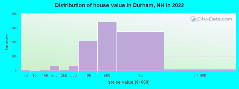
Estimated median house or condo value in 2022: $499,344 (it was $174,900 in 2000)
Durham:
$499,344
NH:
$384,700
Mean prices in 2022:all housing units: $470,404; detached houses: $484,324; townhouses or other attached units: $455,290; in 2-unit structures: $353,163; in 5-or-more-unit structures: $512,154
Median gross rent in 2022: $1,317.
March 2022 cost of living index in Durham: 133.6 (high, U.S. average is 100)
According to our research of New Hampshire and other state lists, there were 6 registered sex offenders living in Durham, New Hampshire as of May 02, 2024. The ratio of all residents to sex offenders in Durham is 1,787 to 1. The ratio of registered sex offenders to all residents in this city is much lower than the state average.
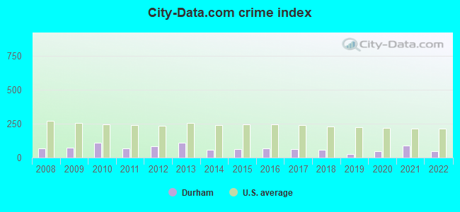
Crime rates in Durham by year
Type
2009
2010
2011
2012
2013
2014
2015
2016
2017
2018
2019
2020
2021
2022
Murders (per 100,000)
0 (0.0)
0 (0.0)
0 (0.0)
0 (0.0)
0 (0.0)
0 (0.0)
0 (0.0)
0 (0.0)
1 (6.0)
0 (0.0)
0 (0.0)
0 (0.0)
0 (0.0)
0 (0.0)
Rapes (per 100,000)
2 (14.5)
9 (61.5)
3 (20.5)
5 (34.0)
10 (65.3)
3 (19.3)
7 (43.6)
8 (46.8)
4 (23.9)
9 (53.5)
2 (11.9)
7 (42.4)
15 (89.0)
6 (38.6)
Robberies (per 100,000)
1 (7.3)
0 (0.0)
0 (0.0)
0 (0.0)
0 (0.0)
1 (6.4)
0 (0.0)
0 (0.0)
0 (0.0)
0 (0.0)
2 (11.9)
0 (0.0)
0 (0.0)
1 (6.4)
Assaults (per 100,000)
11 (79.8)
7 (47.8)
9 (61.4)
16 (108.8)
17 (111.0)
8 (51.4)
5 (31.1)
10 (58.6)
4 (23.9)
2 (11.9)
2 (11.9)
2 (12.1)
3 (17.8)
2 (12.9)
Burglaries (per 100,000)
23 (166.9)
18 (123.0)
14 (95.5)
18 (122.3)
12 (78.4)
18 (115.6)
9 (56.1)
14 (82.0)
22 (131.3)
9 (53.5)
10 (59.5)
6 (36.3)
5 (29.7)
3 (19.3)
Thefts (per 100,000)
101 (732.8)
136 (929.1)
118 (805.1)
97 (659.3)
103 (672.7)
81 (520.2)
60 (373.8)
58 (339.6)
56 (334.3)
44 (261.7)
31 (184.4)
34 (205.9)
36 (213.7)
44 (283.0)
Auto thefts (per 100,000)
2 (14.5)
5 (34.2)
1 (6.8)
2 (13.6)
3 (19.6)
5 (32.1)
4 (24.9)
3 (17.6)
4 (23.9)
0 (0.0)
1 (5.9)
2 (12.1)
2 (11.9)
2 (12.9)
Arson (per 100,000)
0 (0.0)
2 (13.7)
1 (6.8)
3 (20.4)
6 (39.2)
4 (25.7)
1 (6.2)
0 (0.0)
1 (6.0)
0 (0.0)
1 (5.9)
0 (0.0)
0 (0.0)
0 (0.0)
City-Data.com crime index
71.9
107.3
68.1
85.0
108.4
59.1
62.0
69.9
60.3
59.4
27.5
48.1
86.4
49.1
The City-Data.com crime index weighs serious crimes and violent crimes more heavily. Higher means more crime, U.S. average is 246.1. It adjusts for the number of visitors and daily workers commuting into cities.
Latest news from Durham, NH collected exclusively by city-data.com from local newspapers, TV, and radio stations
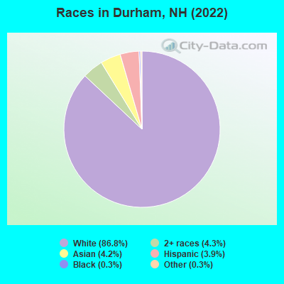
Ancestries: Irish (21.3%), English (9.7%), Italian (8.7%), French Canadian (4.7%), Polish (4.6%), German (3.8%).
Current Local Time: EST time zone
Incorporated in 1732
Elevation: 82 feet
Land area: 2.66 square miles.
Population density: 3,896 people per square mile (average).
526 residents are foreign born (2.3% Asia, 1.6% Europe).
This place:
4.8%
New Hampshire:
6.0%
Median real estate property taxes paid for housing units with mortgages in 2022: $8,925 (1.9%) Median real estate property taxes paid for housing units with no mortgage in 2022: $9,778 (1.8%)
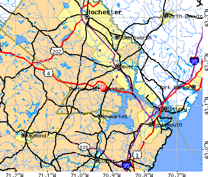
Nearest city with pop. 50,000+: Haverhill, MA (26.2 miles , pop. 58,969).
Nearest city with pop. 200,000+: Boston, MA (57.1 miles , pop. 589,141).
Nearest city with pop. 1,000,000+: Bronx, NY (219.3 miles , pop. 1,332,650).
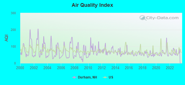
Air Quality Index (AQI) level in 2022 was 61.4. This is about average.
City:
61.4
U.S.:
72.6
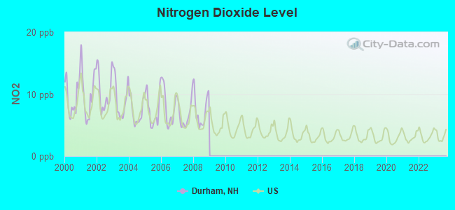
Nitrogen Dioxide (NO2) [ppb] level in 2008 was 7.38. This is significantly worse than average.Closest monitor was 4.6 miles away from the city center.
City:
7.38
U.S.:
5.11
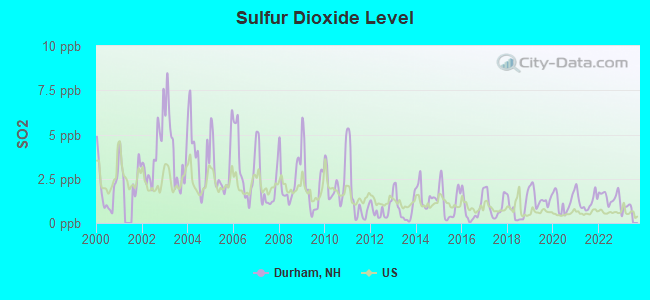
Sulfur Dioxide (SO2) [ppb] level in 2022 was 1.48. This is about average.Closest monitor was 4.6 miles away from the city center.
City:
1.48
U.S.:
1.51
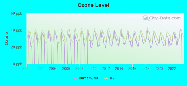
Ozone [ppb] level in 2022 was 29.7. This is about average.Closest monitor was 9.1 miles away from the city center.
City:
29.7
U.S.:
33.3
Particulate Matter (PM10) [µg/m3] level in 2022 was 14.4. This is better than average.Closest monitor was 4.6 miles away from the city center.
City:
14.4
U.S.:
19.2
Particulate Matter (PM2.5) [µg/m3] level in 2022 was 6.41. This is better than average.Closest monitor was 9.2 miles away from the city center.
City:
6.41
U.S.:
8.11
Tornado activity:
Durham-area historical tornado activity is near New Hampshire state average. It is 55% smaller than the overall U.S. average.
On 6/9/1953, a category F3 (max. wind speeds 158-206 mph) tornado 11.9 miles away from the Durham place center injured 5 peopleand causedbetween $5000 and $50,000 in damages.
On 5/3/1976, a category F2 (max. wind speeds 113-157 mph) tornado 3.9 miles away from the place center causedbetween $50,000 and $500,000 in damages.
Earthquake activity:
Durham-area historical earthquake activity is significantly above New Hampshire state average. It is 73% smaller than the overall U.S. average.
On 10/16/2012 at 23:12:25, a magnitude 4.7 (4.7 ML, Depth: 10.0 mi, Class: Light, Intensity: IV - V) earthquake occurred 34.5 miles away from Durham center On 4/20/2002 at 10:50:47, a magnitude 5.3 (5.3 ML, Depth: 3.0 mi, Class: Moderate, Intensity: VI - VII) earthquake occurred 167.8 miles away from the city center On 1/19/1982 at 00:14:42, a magnitude 4.7 (4.5 MB, 4.7 MD, 4.5 LG) earthquake occurred 42.1 miles away from the city center On 10/7/1983 at 10:18:46, a magnitude 5.3 (5.1 MB, 5.3 LG, 5.1 ML) earthquake occurred 180.3 miles away from the city center On 4/20/2002 at 10:50:47, a magnitude 5.2 (5.2 MB, 4.2 MS, 5.2 MW, 5.0 MW) earthquake occurred 167.7 miles away from Durham center On 8/21/1996 at 07:54:14, a magnitude 3.8 (3.8 LG, 3.6 LG, Depth: 6.2 mi, Class: Light, Intensity: II - III) earthquake occurred 75.4 miles away from Durham center Magnitude types: regional Lg-wave magnitude (LG), body-wave magnitude (MB), duration magnitude (MD), local magnitude (ML), surface-wave magnitude (MS), moment magnitude (MW)
Natural disasters:
The number of natural disasters in Strafford County (23) is greater than the US average (15). Major Disasters (Presidential) Declared: 14 Emergencies Declared: 8
Causes of natural disasters: Storms: 8, Floods: 6, Winter Storms: 6, Snowstorms: 5, Hurricanes: 3, Blizzard: 1, Ice Storm: 1, Snow: 1, Snowfall: 1, Tornado: 1, Tropical Storm: 1, Wind: 1, Other: 1 (Note: some incidents may be assigned to more than one category).
Hospitals and medical centers near Durham:
SAINT ANN REHABILITATION AND NURSING CENTER (Nursing Home, about 5 miles away; DOVER, NH)
LANGDON PLACE OF DOVER (Nursing Home, about 5 miles away; DOVER, NH)
KINDRED TRANSITIONAL CARE AND REHABILITATION-DOVER (Nursing Home, about 6 miles away; DOVER, NH)
RIVERSIDE REST HOME (Nursing Home, about 6 miles away; DOVER, NH)
WENTWORTH-DOUGLASS HOSPITAL Acute Care Hospitals (about 6 miles away; DOVER, NH)
WENTWORTH HOME CARE AND HOSPICE, AN AMEDISYS PARTNER (Home Health Center, about 7 miles away; DOVER, NH)
TRI-AREA VNA - HOSPICE (Hospital, about 9 miles away; SOMERSWORTH, NH)
Amtrak station:
DURHAM (3 DEPOT RD.) . Services: ticket office.
Operable nuclear power plant near Durham:
18 miles: Seabrook in Seabrook, NH.
Colleges/Universities in Durham:
University of New Hampshire-Main Campus (Full-time enrollment: 15,243; Location: 105 Main St., Thompson Hall; Public; Website: www.unh.edu; Offers Doctor's degree)
University System of New Hampshire System Office (Location: 25 Concord Road Dunlap Center; Public; Website: www.usnh.edu; Offers Doctor's degree)
Other colleges/universities with over 2000 students near Durham:
Northern Essex Community College (about 25 miles; Haverhill, MA; Full-time enrollment: 4,737)
Southern New Hampshire University (about 28 miles; Manchester, NH; FT enrollment: 16,552)
Mount Washington College (about 30 miles; Manchester, NH; FT enrollment: 2,187)
NHTI-Concord's Community College (about 32 miles; Concord, NH; FT enrollment: 2,865)
Saint Anselm College (about 32 miles; Manchester, NH; FT enrollment: 2,059)
Merrimack College (about 35 miles; North Andover, MA; FT enrollment: 2,734)
University of New England (about 36 miles; Biddeford, ME; FT enrollment: 4,539)
Notable locations in Durham: McGregor Memorial Emergency Medical Services (A), Durham City Hall (B), Ezekiel W Diamond Library (C), Durham Fire Department (D). Display/hide their locations on the map
Churches in Durham include: Unitarian Universalist Church (A), Saint Thomas MOre Parish Church (B), Saint George Episcopal Church (C), Community Church of Durham (D). Display/hide their locations on the map
Hotels: New England Center - Acorns Restaurant Cafe & Lounge (15 Strafford Avenue), Three Chimneys Inn (17 Newmarket Road), University of New Hampshire - New England Center (15 Strafford Avenue).
Court: Durham Town - District Court (99 Main Street).
Birthplace of: Sam Fuld - Baseball player, Deron Quint - NHL player (Chicago Blackhawks, born: Mar 12, 1976), Jeremy Friel - College basketball player (New Hampshire Wildcats), John S. Wells - Politician, Marilla Ricker - Lawyer.
Strafford County has a predicted average indoor radon screening level between 2 and 4 pCi/L (pico curies per liter) - Moderate Potential
Drinking water stations with addresses in Durham and their reported violations in the past:
EMERITUS AT SPRUCE WOOD (Address: 25 WORTHEN RD , Population served: 225, Groundwater):
Past health violations:
MCL, Monthly (TCR) - In JUN-2006, Contaminant: Coliform. Follow-up actions: St Public Notif requested (JUN-27-2006), St Violation/Reminder Notice (JUN-27-2006), St Public Notif received (JUN-27-2006), St Compliance achieved (DEC-28-2006)
Past monitoring violations:
Monitoring and Reporting (DBP) - Between JUL-01-2010 and OCT-01-2010, Contaminant: Chlorine. Follow-up actions: St Violation/Reminder Notice (OCT-29-2010), St Compliance achieved (MAR-16-2011)
MCL, Monthly (TCR) - Between APR-2006 and JUN-2006, Contaminant: Coliform. Follow-up actions: St Public Notif requested (JUL-06-2006), St Violation/Reminder Notice (JUL-06-2006), St Public Notif received (JUL-26-2006), St Formal NOV issued (JUL-28-2006), St Compliance achieved (JUN-27-2007)
MCL, Monthly (TCR) - Between JUL-2005 and SEP-2005, Contaminant: Coliform. Follow-up actions: St Public Notif requested (AUG-19-2005), St Violation/Reminder Notice (AUG-19-2005), St Public Notif received (OCT-24-2005), St Formal NOV issued (JUL-28-2006), St Compliance achieved (JUN-27-2007)
Past monitoring violations:
Failure To Address Deficiency - In JAN-19-2014, Contaminant: GROUNDWATER RULE. Follow-up actions: St Public Notif requested (JAN-30-2014), St Formal NOV issued (JAN-30-2014), St Public Notif received (MAR-27-2014)
3 routine major monitoring violations
DARBY FIELD COMMONS (Population served: 70, Groundwater):
Past health violations:
MCL, Monthly (TCR) - In APR-2013, Contaminant: Coliform. Follow-up actions: St Public Notif requested (APR-16-2013), St Violation/Reminder Notice (APR-16-2013), St Public Notif received (APR-29-2013), St Compliance achieved (FEB-06-2014)
Past monitoring violations:
Monitoring and Reporting (DBP) - Between JUL-01-2010 and OCT-01-2010, Contaminant: Chlorine. Follow-up actions: St Violation/Reminder Notice (OCT-29-2010), St Compliance achieved (MAR-16-2011)
JOHNSON CREEK (Population served: 50, Groundwater):
Past health violations:
MCL, Average - Between APR-2014 and JUN-2014, Contaminant: Arsenic
MCL, Average - Between OCT-2013 and DEC-2013, Contaminant: Arsenic. Follow-up actions: St Public Notif requested (DEC-27-2013), St Violation/Reminder Notice (DEC-27-2013), St Public Notif received (FEB-13-2014)
MCL, Monthly (TCR) - In AUG-2007, Contaminant: Coliform. Follow-up actions: St Public Notif requested (AUG-31-2007), St Violation/Reminder Notice (AUG-31-2007), St Public Notif received (SEP-11-2007), St Compliance achieved (APR-07-2008)
Past monitoring violations:
Monitoring, Repeat Major (TCR) - In SEP-2007, Contaminant: Coliform (TCR). Follow-up actions: St Public Notif requested (OCT-25-2007), St Violation/Reminder Notice (OCT-25-2007), St Public Notif received (NOV-21-2007), St Compliance achieved (APR-07-2008)
One routine major monitoring violation
Average household size:
This place:
2.4 people
New Hampshire:
2.5 people
Percentage of family households:
This place:
38.5%
Whole state:
66.3%
Percentage of households with unmarried partners:
This place:
2.8%
Whole state:
8.3%
Likely homosexual households (counted as self-reported same-sex unmarried-partner households)
Lesbian couples: 0.4% of all households
Gay men: 0.1% of all households
6,328 people in college/university student housing in 2010
People in group quarters in Durham in 2000:
4,573 people in college dormitories (includes college quarters off campus)
29 people in other nonhousehold living situations
3 people in other group homes
Banks with branches in Durham (2011 data):
People's United Bank: Durham Main Branch at 70 Main Street, branch established on 1947/06/18; Durham Branch at 8 Newmarket Road, branch established on 1984/05/26. Info updated 2012/02/16: Bank assets: $27,319.3 mil, Deposits: $20,835.4 mil, headquarters in Bridgeport, CT, positive income, Commercial Lending Specialization, 374 total offices
Federal Savings Bank: Durham Shopping Plaza Branch at 7a Mill Road, branch established on 1890/01/01. Info updated 2011/07/21: Bank assets: $268.8 mil, Deposits: $180.2 mil, headquarters in Dover, NH, positive income, Commercial Lending Specialization, 5 total offices
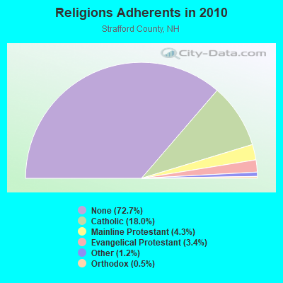
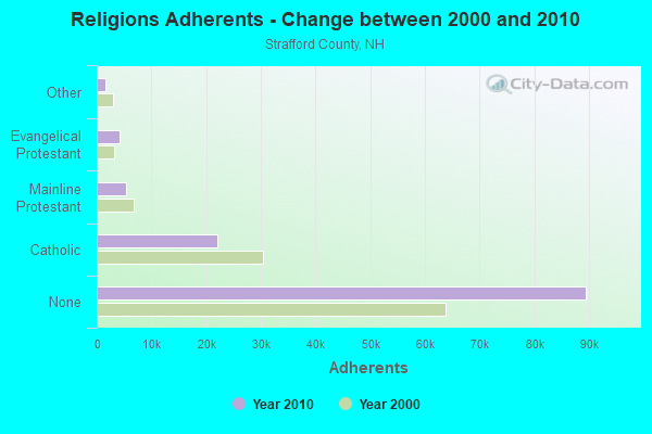
Religion statistics for Durham, NH (based on Strafford County data)
Religion
Adherents
Congregations
Catholic
22,112
11
Mainline Protestant
5,299
21
Evangelical Protestant
4,143
37
Other
1,504
13
Orthodox
575
2
None
89,510
-
Source: Clifford Grammich, Kirk Hadaway, Richard Houseal, Dale E.Jones, Alexei Krindatch, Richie Stanley and Richard H.Taylor. 2012. 2010 U.S.Religion Census: Religious Congregations & Membership Study. Association of Statisticians of American Religious Bodies. Jones, Dale E., et al. 2002. Congregations and Membership in the United States 2000. Nashville, TN: Glenmary Research Center. Graphs represent county-level data
Peter P Geremia, Old Beech Hill Road (Lat: 43.156389 Lon: -70.940000), Type: 92.0, Overall height: 92 m, Registrant: University Of New Hampshire Dba , Geremia@nh.Ultranet.Com, , Durha-m, Phone: (603) 862-2541
Peter P Geremia, Old Beech Hill Rd. (Lat: 43.156389 Lon: -70.940000), Type: 77.0, Overall height: 77 m, Registrant: University Of New Hampshire Dba , Geremia@nh.Ultranet.Com, , Durha-m, Phone: (603) 862-2541
Leila V Moore, Old Beech Hill Road (Lat: 43.156389 Lon: -70.940000), Type: 92.0, Overall height: 92 m, Registrant: University Of New Hampshire Dba , Pgeremia@msn.Com, , Durha-m, Phone: (603) 862-2541
Old Beech Hill Road (Lat: 43.156389 Lon: -70.940000), Type: 92.0, Overall height: 92 m, Registrant: University Of New Hampshire Dba , Geremia@nh.Ultranet.Com, , Durha-m, Phone: (603) 862-2541
Old Beech Hill Rd. (Lat: 43.156389 Lon: -70.940000), Type: 77.0, Overall height: 77 m, Registrant: University Of New Hampshire Dba , Geremia@nh.Ultranet.Com, , Durha-m, Phone: (603) 862-2541
Aircraft: NORTH AMERICAN NAVION (Category: Land, Seats: 5, Weight: Up to 12,499 Pounds, Speed: 126 mph), Engine: CONT MOTOR I0-470 SERIES (260 HP) (Reciprocating) N-Number: 4043K, N4043K, N-4043K, Serial Number: NAV-4-1043, Year manufactured: 1949, Certificate Issue Date: 07/20/2020 Registrant (Individual): Ian C Jackson, 127 Madbury Rd, Durham, NH 03824
Aircraft: CESSNA 182P (Category: Land, Seats: 4, Weight: Up to 12,499 Pounds, Speed: 120 mph), Engine: CONT MOTOR O-470 SERIES (230 HP) (Reciprocating) N-Number: 499MM, N499MM, N-499MM, Serial Number: 18261871, Year manufactured: 1973, Airworthiness Date: 03/30/1973, Certificate Issue Date: 01/03/2018 Registrant (Individual): Donald L Fletcher, 23 Durham Point Rd, Durham, NH 03824
Aircraft: CESSNA 310P (Category: Land, Engines: 2, Seats: 6, Weight: Up to 12,499 Pounds, Speed: 167 mph), Engine: CONT MOTOR IO-470 SER (260 HP) (Reciprocating) N-Number: 60FY, N60FY, N-60FY, Serial Number: 310P0109, Year manufactured: 1969, Airworthiness Date: 12/06/1995, Certificate Issue Date: 01/05/2018 Registrant (Corporation): New Castle Aviation Inc, 118 Piscataqua Rd, Durham, NH 03824
Aircraft: PIPER J3C-65 (Category: Land, Seats: 2, Weight: Up to 12,499 Pounds, Speed: 67 mph), Engine: CONT MOTOR A-65-8 (65 HP) (Reciprocating) N-Number: 92381, N92381, N-92381, Serial Number: 16843, Year manufactured: 1946, Airworthiness Date: 07/14/1956, Certificate Issue Date: 02/12/2019 Registrant (Individual): Christopher J Mihok, 11 Cedar Point Rd, Durham, NH 03824
Detailed PMIC statistics for the following Tracts:0802.01
, 0802.02
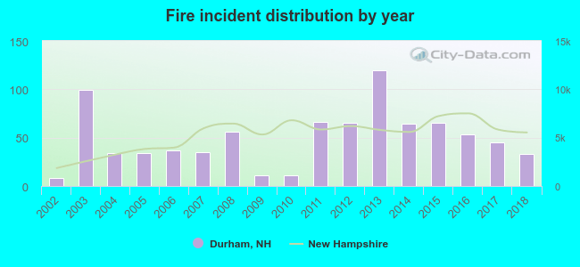
2002 - 2018 National Fire Incident Reporting System (NFIRS) incidents
According to the data from the years 2002 - 2018 the average number of fires per year is 49. The highest number of fires - 120 took place in 2013, and the least - 8 in 2002. The data has a growing trend.
When looking into fire subcategories, the most reports belonged to: Structure Fires (48.4%), and Outside Fires (41.7%).
Fire incident types reported to NFIRS in Durham, NH
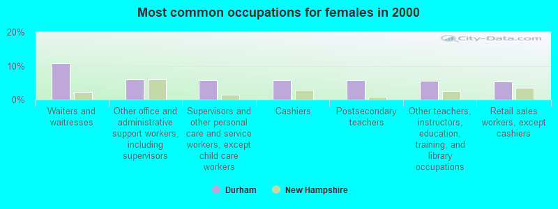
#3 on the list of "Top 101 cities with largest percentage of females in occupations: food preparation and serving related occupations (population 5,000+)"
#9 on the list of "Top 101 cities with the most people having Master's or Doctorate degrees (population 5,000+)"
#11 on the list of "Top 101 cities with the least people living the same house as 1 year ago (population 5,000+))"
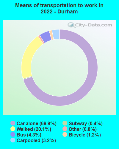
#18 on the list of "Top 101 cities with the most people walking to work (population 5,000+)"
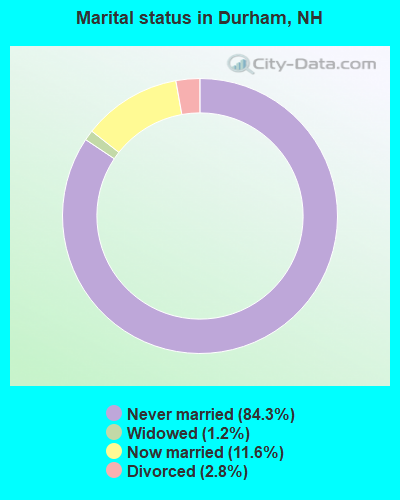
#23 on the list of "Top 101 cities where the highest percentage of females (15+ years) which never married (with at least 1,000 females in this group)"
#23 on the list of "Top 100 cities with highest percentage of college students (pop. 5,000+)"
#25 on the list of "Top 101 cities where the highest percentage of males (15+ years) which never married (with at least 1,000 males in this group)"
#26 on the list of "Top 101 cities with the largest percentage of people in college dormitories (includes college quarters off campus) (population 1,000+)"
#27 on the list of "Top 100 best educated cities (highest percentage of bachelor degree holding residents) (pop. 5,000+)"
#28 on the list of "Top 101 cities with the largest household incomes disparities (population 5,000+)"
#32 on the list of "Top 101 cities with the smallest percentage of divorced people (15+ years)(population 5,000+)"
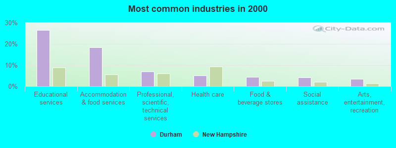
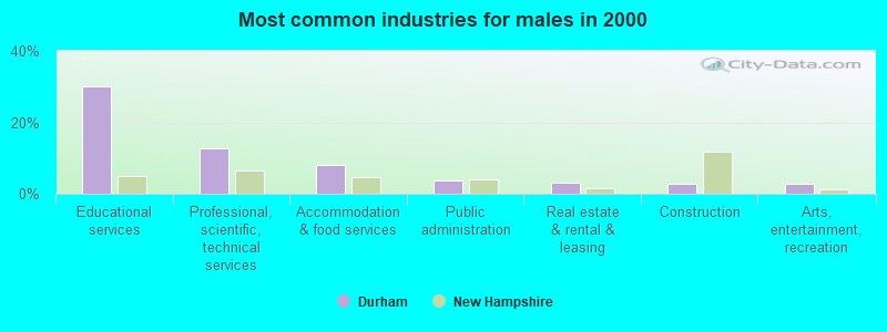
#35 on the list of "Top 101 cities with largest percentage of males in industries: educational services (population 5,000+)"
#40 on the list of "Top 101 cities with the lowest percentage of family households, population 10,000+"
#47 on the list of "Top 101 cities with largest percentage of females in industries: accommodation and food services (population 5,000+)"
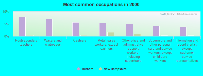
#59 on the list of "Top 101 cities with largest percentage of males in occupations: personal care and service occupations (population 5,000+)"
#66 on the list of "Top 101 cities with the largest positive percentage difference between never married females and males (15+ years) (with at least 1,000 females never married)"
#76 on the list of "Top 100 cities with youngest residents"
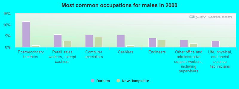
#77 on the list of "Top 101 cities with largest percentage of males in occupations: education, training, and library occupations (population 5,000+)"
#99 on the list of "Top 101 cities with the most people having Doctorate degrees (population 500+)"
#99 on the list of "Top 100 cities with strongest arts, entertainment, recreation, accommodation and food services industries (pop. 5,000+)"
#78 on the list of "Top 101 counties with the lowest percentage of residents that keep firearms around their homes"
#82 on the list of "Top 101 counties with the highest average weight of females"
#85 on the list of "Top 101 counties with the lowest number of births per 1000 residents 2007-2013"
#91 on the list of "Top 101 counties with the highest percentage of residents that smoked 100+ cigarettes in their lives"


 Recent articles from our blog. Our writers, many of them Ph.D. graduates or candidates, create easy-to-read articles on a wide variety of topics.

 (26.2 miles


 According to the data from the years 2002 - 2018 the average number of fires per year is 49. The highest number of fires - 120 took place in 2013, and the least - 8 in 2002. The data has a growing trend.
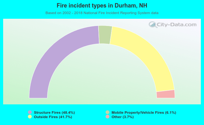 When looking into fire subcategories, the most reports belonged to: Structure Fires (48.4%), and Outside Fires (41.7%).