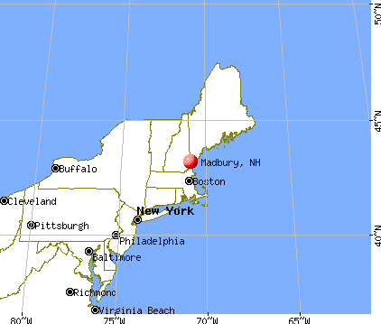
Madbury, New Hampshire
Submit your own pictures of this town and show them to the world
- OSM Map
- General Map
- Google Map
- MSN Map

Population change since 2000: +17.4%
 |
| Males: 913 | |
| Females: 858 |
| Median resident age: | 40.6 years |
| New Hampshire median age: | 43.9 years |
Zip codes: 03820.
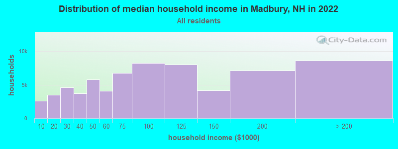
| Madbury: | $107,567 |
| NH: | $89,992 |
Estimated per capita income in 2022: $57,553 (it was $26,524 in 2000)
Madbury town income, earnings, and wages data
Estimated median house or condo value in 2022: $518,156 (it was $167,200 in 2000)
| Madbury: | $518,156 |
| NH: | $384,700 |
Mean prices in 2022: all housing units: $372,213; detached houses: $404,882; townhouses or other attached units: $390,591; in 2-unit structures: $310,268; in 3-to-4-unit structures: $385,130; in 5-or-more-unit structures: $243,262; mobile homes: $123,219
Detailed information about poverty and poor residents in Madbury, NH


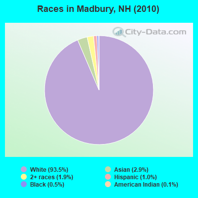
- 1,65593.5%White alone
- 522.9%Asian alone
- 341.9%Two or more races
- 181.0%Hispanic
- 80.5%Black alone
- 20.1%American Indian alone
- 10.06%Native Hawaiian and Other
Pacific Islander alone - 10.06%Other race alone
Races in Madbury detailed stats: ancestries, foreign born residents, place of birth
According to our research of New Hampshire and other state lists, there was 1 registered sex offender living in Madbury, New Hampshire as of May 17, 2024.
The ratio of all residents to sex offenders in Madbury is 1,771 to 1.
The ratio of registered sex offenders to all residents in this city is much lower than the state average.
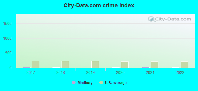
Type |
2017 |
2018 |
2019 |
2020 |
2021 |
2022 |
|---|---|---|---|---|---|---|
| Murders (per 100,000) | 0 (0.0) | 0 (0.0) | 0 (0.0) | 0 (0.0) | 0 (0.0) | 0 (0.0) |
| Rapes (per 100,000) | 0 (0.0) | 0 (0.0) | 0 (0.0) | 0 (0.0) | 0 (0.0) | 0 (0.0) |
| Robberies (per 100,000) | 0 (0.0) | 0 (0.0) | 0 (0.0) | 0 (0.0) | 0 (0.0) | 0 (0.0) |
| Assaults (per 100,000) | 1 (54.7) | 0 (0.0) | 0 (0.0) | 0 (0.0) | 0 (0.0) | 0 (0.0) |
| Burglaries (per 100,000) | 1 (54.7) | 0 (0.0) | 0 (0.0) | 0 (0.0) | 1 (52.3) | 1 (51.6) |
| Thefts (per 100,000) | 6 (328.2) | 7 (378.4) | 2 (107.1) | 2 (105.4) | 8 (418.2) | 3 (154.8) |
| Auto thefts (per 100,000) | 0 (0.0) | 0 (0.0) | 0 (0.0) | 1 (52.7) | 1 (52.3) | 0 (0.0) |
| Arson (per 100,000) | 0 (0.0) | 0 (0.0) | 0 (0.0) | 0 (0.0) | 0 (0.0) | 0 (0.0) |
| City-Data.com crime index | 27.9 | 15.1 | 4.3 | 8.4 | 24.6 | 9.8 |
The City-Data.com crime index weighs serious crimes and violent crimes more heavily. Higher means more crime, U.S. average is 246.1. It adjusts for the number of visitors and daily workers commuting into cities.
Crime rate in Madbury detailed stats: murders, rapes, robberies, assaults, burglaries, thefts, arson
 Recent articles from our blog. Our writers, many of them Ph.D. graduates or candidates, create easy-to-read articles on a wide variety of topics.

 | Best safe towns for commute to Portsmouth NH (34 replies) |
| Neighborhood Help ... Near Portsmouth (6 replies) |
| Moving from Va to NH looking for some advice :) (32 replies) |
| Moving to New Hampshire (Lebanon, Hanover, Keene, Grantham, Plainfield, Enfield, Etna) (38 replies) |
| Relocating to NH Seacoast (26 replies) |
| Best place for a family to live close to manchester (30 replies) |
Latest news from Madbury, NH collected exclusively by city-data.com from local newspapers, TV, and radio stations
Ancestries: English (23.1%), Irish (15.5%), French (12.9%), German (12.7%), French Canadian (11.3%), Italian (7.6%).
Current Local Time: EST time zone
Incorporated in 1755
Elevation: 104 feet
Land area: 11.7 square miles.
Population density: 152 people per square mile (very low).
65 residents are foreign born (2.4% Europe, 1.2% North America, 0.6% Asia).
| This town: | 4.3% |
| New Hampshire: | 4.4% |
| Madbury town: | 2.6% ($4,268) |
| New Hampshire: | 2.3% ($2,946) |
Nearest city with pop. 50,000+: Haverhill, MA  (28.0 miles , pop. 58,969).
Nearest city with pop. 200,000+: Boston, MA (58.9 miles , pop. 589,141).
Nearest city with pop. 1,000,000+: Bronx, NY (220.7 miles , pop. 1,332,650).
Nearest cities:
), ), ), )Latitude: 43.16 N, Longitude: 70.92 W
Area code commonly used in this area: 603

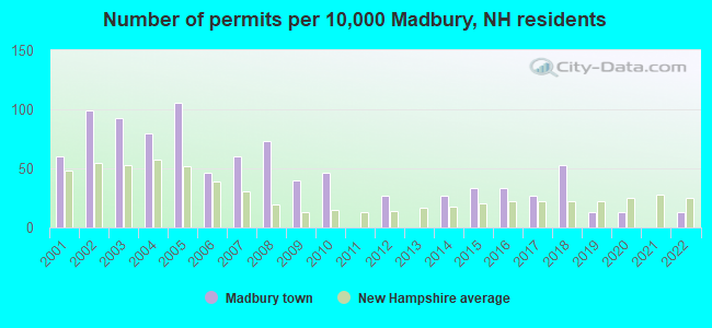
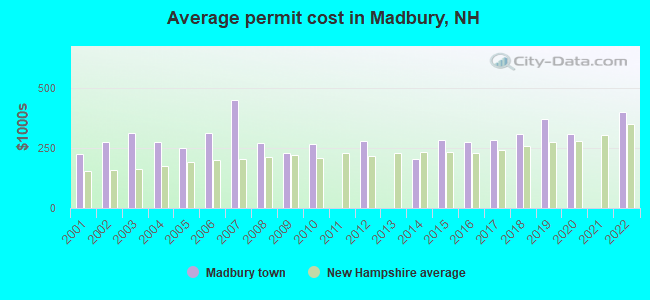
Single-family new house construction building permits:
- 2022: 2 buildings, average cost: $400,000
- 2020: 2 buildings, average cost: $307,700
- 2019: 2 buildings, average cost: $370,000
- 2018: 8 buildings, average cost: $308,100
- 2017: 4 buildings, average cost: $283,800
- 2016: 5 buildings, average cost: $275,000
- 2015: 5 buildings, average cost: $284,000
- 2014: 4 buildings, average cost: $205,000
- 2012: 4 buildings, average cost: $281,300
- 2010: 7 buildings, average cost: $265,700
- 2009: 6 buildings, average cost: $227,500
- 2008: 11 buildings, average cost: $269,300
- 2007: 9 buildings, average cost: $450,000
- 2006: 7 buildings, average cost: $310,700
- 2005: 16 buildings, average cost: $248,400
- 2004: 12 buildings, average cost: $275,000
- 2003: 14 buildings, average cost: $312,500
- 2002: 15 buildings, average cost: $275,000
- 2001: 9 buildings, average cost: $225,000
| Here: | 2.0% |
| New Hampshire: | 2.5% |
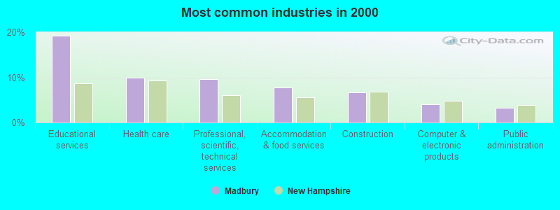
- Educational services (19.3%)
- Health care (9.9%)
- Professional, scientific, technical services (9.6%)
- Accommodation & food services (7.7%)
- Construction (6.7%)
- Computer & electronic products (4.0%)
- Public administration (3.3%)
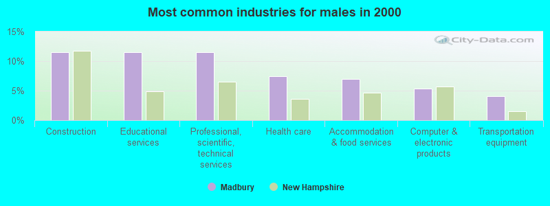
- Construction (11.5%)
- Educational services (11.5%)
- Professional, scientific, technical services (11.5%)
- Health care (7.4%)
- Accommodation & food services (7.0%)
- Computer & electronic products (5.4%)
- Transportation equipment (4.1%)
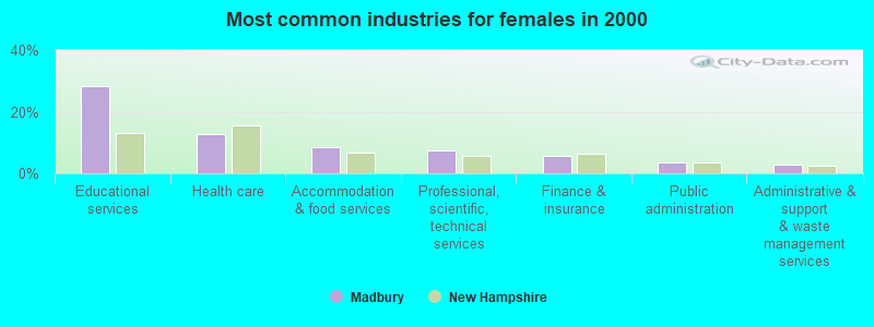
- Educational services (28.5%)
- Health care (12.8%)
- Accommodation & food services (8.5%)
- Professional, scientific, technical services (7.4%)
- Finance & insurance (5.6%)
- Public administration (3.5%)
- Administrative & support & waste management services (2.7%)
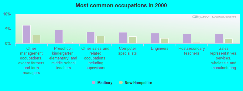
- Other management occupations, except farmers and farm managers (6.2%)
- Preschool, kindergarten, elementary, and middle school teachers (4.6%)
- Other sales and related occupations, including supervisors (3.9%)
- Computer specialists (3.8%)
- Engineers (3.5%)
- Postsecondary teachers (3.3%)
- Sales representatives, services, wholesale and manufacturing (3.3%)
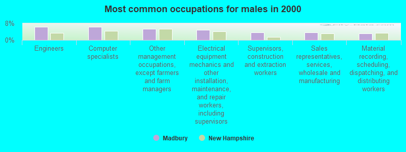
- Engineers (6.3%)
- Computer specialists (6.3%)
- Other management occupations, except farmers and farm managers (5.4%)
- Electrical equipment mechanics and other installation, maintenance, and repair workers, including supervisors (4.7%)
- Supervisors, construction and extraction workers (3.6%)
- Sales representatives, services, wholesale and manufacturing (3.6%)
- Material recording, scheduling, dispatching, and distributing workers (3.2%)

- Preschool, kindergarten, elementary, and middle school teachers (7.7%)
- Other management occupations, except farmers and farm managers (7.2%)
- Other sales and related occupations, including supervisors (5.6%)
- Postsecondary teachers (4.3%)
- Building and grounds cleaning and maintenance occupations (4.0%)
- Secretaries and administrative assistants (3.5%)
- Teachers, secondary school (3.5%)
Average climate in Madbury, New Hampshire
Based on data reported by over 4,000 weather stations


(lower is better)
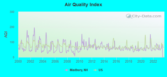
Air Quality Index (AQI) level in 2022 was 61.4. This is about average.
| City: | 61.4 |
| U.S.: | 72.6 |
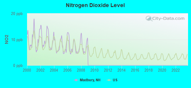
Nitrogen Dioxide (NO2) [ppb] level in 2008 was 7.38. This is significantly worse than average. Closest monitor was 3.1 miles away from the city center.
| City: | 7.38 |
| U.S.: | 5.11 |
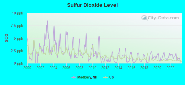
Sulfur Dioxide (SO2) [ppb] level in 2022 was 1.48. This is about average. Closest monitor was 3.1 miles away from the city center.
| City: | 1.48 |
| U.S.: | 1.51 |
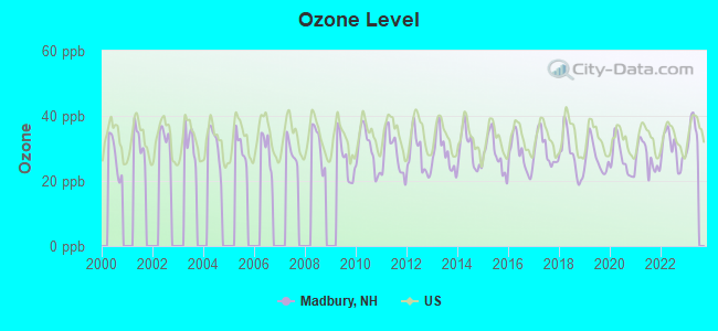
Ozone [ppb] level in 2022 was 29.7. This is about average. Closest monitor was 8.2 miles away from the city center.
| City: | 29.7 |
| U.S.: | 33.3 |
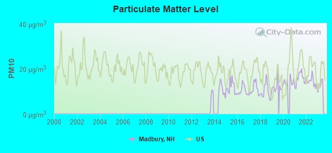
Particulate Matter (PM10) [µg/m3] level in 2022 was 14.4. This is better than average. Closest monitor was 3.1 miles away from the city center.
| City: | 14.4 |
| U.S.: | 19.2 |
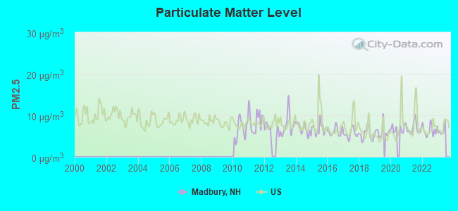
Particulate Matter (PM2.5) [µg/m3] level in 2022 was 6.41. This is better than average. Closest monitor was 10.1 miles away from the city center.
| City: | 6.41 |
| U.S.: | 8.11 |
Tornado activity:
Madbury-area historical tornado activity is near New Hampshire state average. It is 55% smaller than the overall U.S. average.
On 6/9/1953, a category F3 (max. wind speeds 158-206 mph) tornado 13.7 miles away from the Madbury town center injured 5 people and caused between $5000 and $50,000 in damages.
On 5/3/1976, a category F2 (max. wind speeds 113-157 mph) tornado 4.4 miles away from the town center caused between $50,000 and $500,000 in damages.
Earthquake activity:
Madbury-area historical earthquake activity is significantly above New Hampshire state average. It is 73% smaller than the overall U.S. average.On 10/16/2012 at 23:12:25, a magnitude 4.7 (4.7 ML, Depth: 10.0 mi, Class: Light, Intensity: IV - V) earthquake occurred 32.8 miles away from the city center
On 4/20/2002 at 10:50:47, a magnitude 5.3 (5.3 ML, Depth: 3.0 mi, Class: Moderate, Intensity: VI - VII) earthquake occurred 166.9 miles away from the city center
On 1/19/1982 at 00:14:42, a magnitude 4.7 (4.5 MB, 4.7 MD, 4.5 LG) earthquake occurred 41.2 miles away from the city center
On 10/7/1983 at 10:18:46, a magnitude 5.3 (5.1 MB, 5.3 LG, 5.1 ML) earthquake occurred 179.8 miles away from Madbury center
On 4/20/2002 at 10:50:47, a magnitude 5.2 (5.2 MB, 4.2 MS, 5.2 MW, 5.0 MW) earthquake occurred 166.8 miles away from the city center
On 8/21/1996 at 07:54:14, a magnitude 3.8 (3.8 LG, 3.6 LG, Depth: 6.2 mi, Class: Light, Intensity: II - III) earthquake occurred 73.7 miles away from Madbury center
Magnitude types: regional Lg-wave magnitude (LG), body-wave magnitude (MB), duration magnitude (MD), local magnitude (ML), surface-wave magnitude (MS), moment magnitude (MW)
Natural disasters:
The number of natural disasters in Strafford County (23) is greater than the US average (15).Major Disasters (Presidential) Declared: 14
Emergencies Declared: 8
Causes of natural disasters: Storms: 8, Floods: 6, Winter Storms: 6, Snowstorms: 5, Hurricanes: 3, Blizzard: 1, Ice Storm: 1, Snow: 1, Snowfall: 1, Tornado: 1, Tropical Storm: 1, Wind: 1, Other: 1 (Note: some incidents may be assigned to more than one category).
Hospitals and medical centers near Madbury:
- LANGDON PLACE OF DOVER (Nursing Home, about 4 miles away; DOVER, NH)
- KINDRED TRANSITIONAL CARE AND REHABILITATION-DOVER (Nursing Home, about 4 miles away; DOVER, NH)
- RIVERSIDE REST HOME (Nursing Home, about 4 miles away; DOVER, NH)
- WENTWORTH-DOUGLASS HOSPITAL Acute Care Hospitals (about 5 miles away; DOVER, NH)
- SAINT ANN REHABILITATION AND NURSING CENTER (Nursing Home, about 5 miles away; DOVER, NH)
- WENTWORTH HOME CARE AND HOSPICE, AN AMEDISYS PARTNER (Home Health Center, about 5 miles away; DOVER, NH)
- TRI-AREA VNA - HOSPICE (Hospital, about 7 miles away; SOMERSWORTH, NH)
Operable nuclear power plant near Madbury:
- 20 miles: Seabrook in Seabrook, NH.
Colleges/universities with over 2000 students nearest to Madbury:
- University of New Hampshire-Main Campus (about 3 miles; Durham, NH; Full-time enrollment: 15,243)
- Northern Essex Community College (about 27 miles; Haverhill, MA; FT enrollment: 4,737)
- Southern New Hampshire University (about 29 miles; Manchester, NH; FT enrollment: 16,552)
- Mount Washington College (about 31 miles; Manchester, NH; FT enrollment: 2,187)
- NHTI-Concord's Community College (about 31 miles; Concord, NH; FT enrollment: 2,865)
- Saint Anselm College (about 33 miles; Manchester, NH; FT enrollment: 2,059)
- University of New England (about 34 miles; Biddeford, ME; FT enrollment: 4,539)
Public elementary/middle school in Madbury:
- MOHARIMET SCHOOL (Students: 356, Location: 11 LEE RD., Grades: KG-4)
Points of interest:
Notable location: Madbury Fire Department (A). Display/hide its location on the map
Churches in Madbury include: Full Gospel Church (A), Madbury Church (B). Display/hide their locations on the map
Cemeteries: Hayes Cemetery (1), Jenkins Cemetery (2), James Cemetery (3), Budge Cemetery (4), Sanders Cemetery (5). Display/hide their locations on the map
Lakes and reservoirs: Barbadoes Pond (A), Hoyt Pond (B), Bellamy Reservoir (C). Display/hide their locations on the map
Streams, rivers, and creeks: Mallego Brook (A), Gerrish Brook (B), Dube Brook (C). Display/hide their locations on the map
| This town: | 2.8 people |
| New Hampshire: | 2.5 people |
| This town: | 76.7% |
| Whole state: | 66.3% |
| This town: | 6.7% |
| Whole state: | 8.3% |
Likely homosexual households (counted as self-reported same-sex unmarried-partner households)
- Lesbian couples: 1.1% of all households
- Gay men: 0.6% of all households
| This town: | 5.8% |
| Whole state: | 6.5% |
| This town: | 1.7% |
| Whole state: | 2.8% |
For population 15 years and over in Madbury:
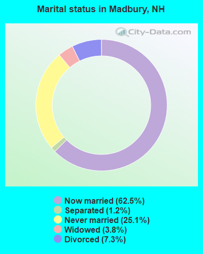
- Never married: 25.1%
- Now married: 62.5%
- Separated: 1.2%
- Widowed: 3.8%
- Divorced: 7.3%
For population 25 years and over in Madbury:
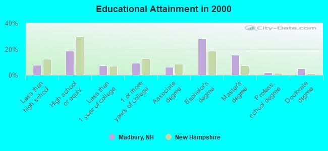
- High school or higher: 92.3%
- Bachelor's degree or higher: 50.5%
- Graduate or professional degree: 22.3%
- Unemployed: 2.4%
- Mean travel time to work (commute): 24.2 minutes
| Here: | 10.9 |
| New Hampshire average: | 10.9 |
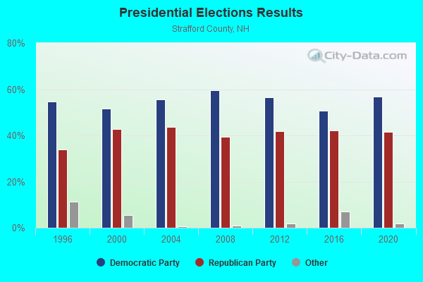
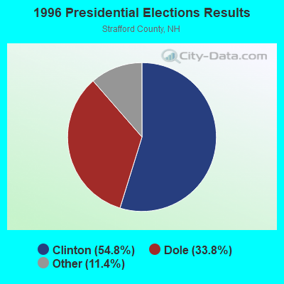
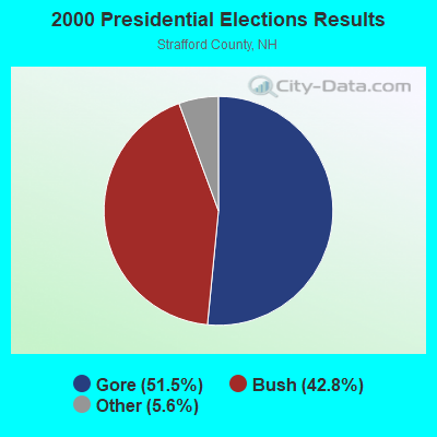


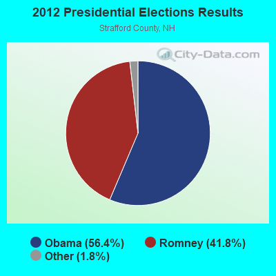


Graphs represent county-level data. Detailed 2008 Election Results
Religion statistics for Madbury, NH (based on Strafford County data)
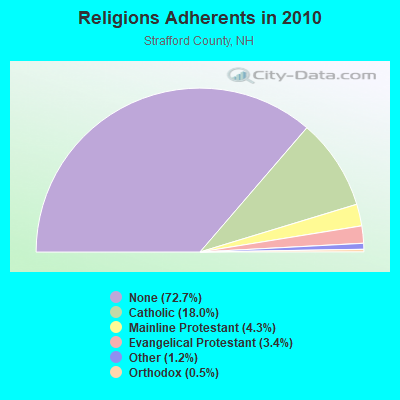
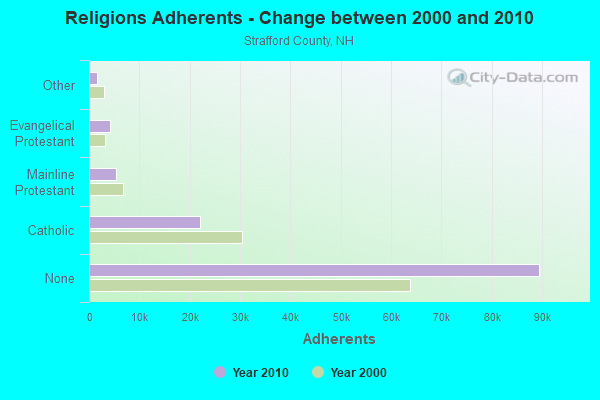
| Religion | Adherents | Congregations |
|---|---|---|
| Catholic | 22,112 | 11 |
| Mainline Protestant | 5,299 | 21 |
| Evangelical Protestant | 4,143 | 37 |
| Other | 1,504 | 13 |
| Orthodox | 575 | 2 |
| None | 89,510 | - |
Food Environment Statistics:
| Strafford County: | 1.73 / 10,000 pop. |
| New Hampshire: | 2.14 / 10,000 pop. |
| Here: | 0.08 / 10,000 pop. |
| New Hampshire: | 0.15 / 10,000 pop. |
| This county: | 2.48 / 10,000 pop. |
| New Hampshire: | 1.78 / 10,000 pop. |
| This county: | 3.80 / 10,000 pop. |
| State: | 4.02 / 10,000 pop. |
| Strafford County: | 8.17 / 10,000 pop. |
| New Hampshire: | 9.70 / 10,000 pop. |
| This county: | 8.8% |
| State: | 7.6% |
| Strafford County: | 26.2% |
| State: | 24.4% |
| Here: | 14.0% |
| New Hampshire: | 15.9% |
Strongest AM radio stations in Madbury:
- WTSN (1270 AM; 5 kW; DOVER, NH; Owner: GARRISON CITY BROADCASTING, INC.)
- WGIN (930 AM; 10 kW; ROCHESTER, NH; Owner: CAPSTAR TX LIMITED PARTNERSHIP)
- WRKO (680 AM; 50 kW; BOSTON, MA; Owner: ENTERCOM BOSTON LICENSE, LLC)
- WGIP (1540 AM; 5 kW; EXETER, NH; Owner: CAPSTAR TX LIMITED PARTNERSHIP)
- WEEI (850 AM; 50 kW; BOSTON, MA; Owner: ENTERCOM BOSTON LICENSE, LLC)
- WBZ (1030 AM; 50 kW; BOSTON, MA; Owner: INFINITY BROADCASTING OPERATIONS, INC.)
- WWZN (1510 AM; 50 kW; BOSTON, MA; Owner: ROSE CITY RADIO CORPORATION)
- WDER (1320 AM; 10 kW; DERRY, NH; Owner: BLOUNT COMMUNICATIONS, INC. OF NH)
- WKOX (1200 AM; 50 kW; FRAMINGHAM, MA; Owner: CAPSTAR TX LIMITED PARTNERSHIP)
- WCRN (830 AM; 50 kW; WORCESTER, MA; Owner: CARTER BROADCASTING CORPORATION)
- WBIX (1060 AM; 40 kW; NATICK, MA; Owner: LANGER BROADCASTING CORPORATION)
- WGIR (610 AM; 5 kW; MANCHESTER, NH; Owner: CAPSTAR TX LIMITED PARTNERSHIP)
- WMYF (1380 AM; 1 kW; PORTSMOUTH, NH; Owner: CAPSTAR TX LIMITED PARTNERSHIP)
Strongest FM radio stations in Madbury:
- WUNH (91.3 FM; DURHAM, NH; Owner: UNIVERSITY OF NEW HAMPSHIRE)
- WOKQ (97.5 FM; DOVER, NH; Owner: CITADEL BROADCASTING COMPANY)
- WBYY (98.7 FM; SOMERSWORTH, NH; Owner: GARRISON CITY BROADCASTING, INC.)
- WSHK (105.3 FM; KITTERY, ME; Owner: CITADEL BROADCASTING COMPANY)
- WUBB (95.3 FM; YORK CENTER, ME; Owner: CAPSTAR TX LIMITED PARTNERSHIP)
- WQSO (96.7 FM; ROCHESTER, NH; Owner: CAPSTAR TX LIMITED PARTNERSHIP)
- WHEB (100.3 FM; PORTSMOUTH, NH; Owner: CAPSTAR TX LIMITED PARTNERSHIP)
- WERZ (107.1 FM; EXETER, NH; Owner: CAPSTAR TX LIMITED PARTNERSHIP)
- WMEX (106.5 FM; FARMINGTON, NH; Owner: WIMMEX, LLC)
- WSCY (106.9 FM; MOULTONBOROUGH, NH; Owner: NORTHEAST COMMUNICATIONS CORPORATION)
- WPHX-FM (92.1 FM; SANFORD, ME; Owner: FNX BROADCASTING LLC)
- WSEW (88.5 FM; SANFORD, ME; Owner: WORD RADIO EDUCATIONAL FOUNDATION)
- WPKQ (103.7 FM; NORTH CONWAY, NH; Owner: CITADEL BROADCASTING COMPANY)
- WHOM (94.9 FM; MT. WASHINGTON, NH; Owner: CITADEL BROADCASTING COMPANY)
- WMEA (90.1 FM; PORTLAND, ME; Owner: MAINE PUBLIC BROADCASTING CORPORATION)
- WLKZ (104.9 FM; WOLFEBORO, NH; Owner: TELE-MEDIA COMPANY OF NEW HAMPSHIRE, L.L.C.)
- WNHI (93.3 FM; BELMONT, NH; Owner: CONCORD BROADCASTING, L.L.C.)
- WGIR-FM (101.1 FM; MANCHESTER, NH; Owner: CAPSTAR TX LIMITED PARTNERSHIP)
- WQLL (96.5 FM; BEDFORD, NH; Owner: SAGA COMMUNICATIONS OF NEW ENGLAND, LLC)
- WXRV (92.5 FM; HAVERHILL, MA; Owner: BEANPOT BROADCASTING CORP.)
TV broadcast stations around Madbury:
- WMEA-TV (Channel 26; BIDDEFORD, ME; Owner: MAINE PUBLIC BROADCASTING CORP.)
- WHDN-LP (Channel 26; BOSTON, MA; Owner: GUENTER MARKSTEINER)
- WENH-TV (Channel 11; DURHAM, NH; Owner: UNIVERSITY OF NEW HAMPSHIRE)
- WMTW-TV (Channel 8; POLAND SPRING, ME; Owner: WMTW BROADCAST GROUP, LLC)
- WFXZ-CA (Channel 24; BOSTON, MA; Owner: BOSTON BROADCASTING CORP.)
- WCSH (Channel 6; PORTLAND, ME; Owner: PACIFIC AND SOUTHERN COMPANY, INC.)
- WPXG (Channel 21; CONCORD, NH; Owner: PAXSON BOSTON-68 LICENSE, INC.)
Madbury fatal accident list:
Sep 29, 2004 08:45 AM, Sr-9, Barrington Town Line, Vehicles: 2, Persons: 2, Fatalities: 1
Jun 22, 2000 05:57 PM, Madbury Rd, Vehicles: 2, Persons: 2, Fatalities: 1
Sep 2, 1987 03:00 PM, 6064000000, Vehicles: 1, Persons: 2, Fatalities: 1
- National Bridge Inventory (NBI) Statistics
- 3Number of bridges
- 33ft / 9.9mTotal length
- $9,426,000Total costs
- 28,190Total average daily traffic
- 1,126Total average daily truck traffic
- 41,720Total future (year 2042) average daily traffic
FCC Registered Cell Phone Towers:
1 (See the full list of FCC Registered Cell Phone Towers in Madbury)FCC Registered Antenna Towers:
13 (See the full list of FCC Registered Antenna Towers)FCC Registered Broadcast Land Mobile Towers:
2- S Side Old Stage Rd .2 Mi E Of Int With Mill Hill Rd (Lat: 43.184250 Lon: -70.940611), Call Sign: KJA329, Licensee ID: L00071740,
Assigned Frequencies: 31.7600 MHz, Grant Date: 04/08/1996, Expiration Date: 04/19/2001, Cancellation Date: 06/24/2001, Registrant: Clifton E Fitch, 24 Fitch Rd, Dover, NH 03820, Phone: (603) 749-4848
- 17 Littleworth Road (Lat: 43.191139 Lon: -70.935194), Type: Pole, Structure height: 6.1 m, Call Sign: WQCB313,
Assigned Frequencies: 43.0600 MHz, Grant Date: 01/21/2005, Expiration Date: 01/21/2015, Cancellation Date: 11/25/2014, Certifier: Steve Groves, Registrant: Keller And Heckman LLP, 1001 G Street, Nw, Suite 500 West, Washington, DC 20001, Phone: (202) 434-4100, Fax: (202) 434-4646, Email:
FCC Registered Microwave Towers:
1- 72 Knox Marsh Rd (Lat: 43.172861 Lon: -70.916167), Overall height: 60.7 m, Call Sign: WMG308,
Assigned Frequencies: 948.000 MHz, Grant Date: 08/10/1993, Expiration Date: 04/01/2006, Cancellation Date: 02/15/2005, Registrant: New Hampshire Gospel Radio, Inc., Po Box 40, Concord, NH 03302
FCC Registered Amateur Radio Licenses:
21 (See the full list of FCC Registered Amateur Radio Licenses in Madbury)FAA Registered Aircraft:
6- Aircraft: LUSCOMBE 8E (Category: Land, Seats: 2, Weight: Up to 12,499 Pounds, Speed: 86 mph), Engine: CONT MOTOR C85 SERIES (85 HP) (Reciprocating)
N-Number: 2399K, N2399K, N-2399K, Serial Number: 5126, Year manufactured: 1947, Airworthiness Date: 09/26/1960, Certificate Issue Date: 05/12/2015
Registrant (Individual): Joseph B Moriarty, 33 Mill Hill Rd, Madbury, NH 03823 - Aircraft: PIPER PA-28-181 (Category: Land, Seats: 4, Weight: Up to 12,499 Pounds, Speed: 105 mph), Engine: LYCOMING 0-360-A1D (180 HP) (Reciprocating)
N-Number: 4180W, N4180W, N-4180W, Serial Number: 2843408, Year manufactured: 2000, Airworthiness Date: 12/07/2000, Certificate Issue Date: 04/22/2002
Registrant (Co-Owned): Bruce E Hodson, 92 Hayes Rd, Madbury, NH 03820, Other Owners: Rhonda Jablonski-Hodson - Aircraft: NAVAL AIRCRAFT FACTORY N3N-3 (Category: Land, Seats: 2, Weight: Up to 12,499 Pounds, Speed: 94 mph), Engine: P&W R1340 SERIES (600 HP) (Reciprocating)
N-Number: 45081, N45081, N-45081, Serial Number: 2689, Year manufactured: 1941, Airworthiness Date: 06/15/1956, Certificate Issue Date: 03/24/1988
Registrant (Individual): Joseph B Moriarty, 33 Mill Hill Rd, Madbury, NH 03823 - Aircraft: NAVAL AIRCRAFT FACTORY N3N-3 (Category: Land, Seats: 2, Weight: Up to 12,499 Pounds, Speed: 94 mph), Engine: P&W R-985 SERIES (450 HP) (Reciprocating)
N-Number: 45218, N45218, N-45218, Serial Number: 2683, Year manufactured: 1941, Airworthiness Date: 11/25/1955, Certificate Issue Date: 03/24/1988
Registrant (Individual): Joseph B Moriarty, 33 Mill Hill Rd, Madbury, NH 03823 - Aircraft: NAVAL AIRCRAFT FACTORY N3N-3 (Category: Land, Seats: 2, Weight: Up to 12,499 Pounds, Speed: 94 mph), Engine: Reciprocating
N-Number: 4742C, N4742C, N-4742C, Serial Number: 1970, Certificate Issue Date: 02/14/2011
Registrant (Individual): Joseph B Moriarty, 33 Mill Hill Rd, Madbury, NH 03823 - Aircraft: GLOBE GC-1B (Category: Land, Seats: 2, Weight: Up to 12,499 Pounds, Speed: 105 mph), Engine: CONT MOTOR C145 SERIES (145 HP) (Reciprocating)
N-Number: 78231, N78231, N-78231, Serial Number: 2231, Year manufactured: 1949, Airworthiness Date: 12/04/1955, Certificate Issue Date: 06/11/1968
Registrant (Individual): Joseph B Jr Moriarty, 33 Mill Hill Rd, Madbury, NH 03823
2003 - 2018 National Fire Incident Reporting System (NFIRS) incidents
- Fire incident types reported to NFIRS in Madbury, NH
- 5844.3%Outside Fires
- 5239.7%Structure Fires
- 1813.7%Mobile Property/Vehicle Fires
- 32.3%Other
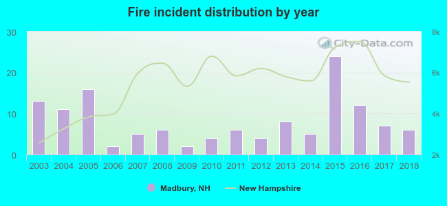 Based on the data from the years 2003 - 2018 the average number of fires per year is 8. The highest number of reported fires - 24 took place in 2015, and the least - 2 in 2006. The data has a dropping trend.
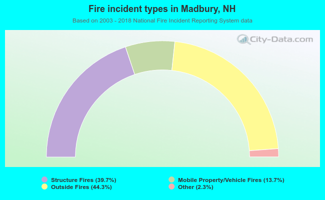 When looking into fire subcategories, the most incidents belonged to: Outside Fires (44.3%), and Structure Fires (39.7%).
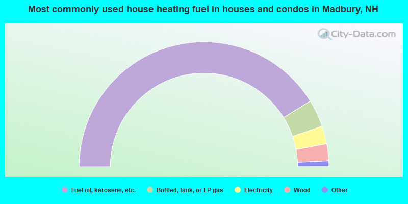
- 82.4%Fuel oil, kerosene, etc.
- 7.1%Bottled, tank, or LP gas
- 4.6%Electricity
- 4.4%Wood
- 1.0%Utility gas
- 0.5%Solar energy
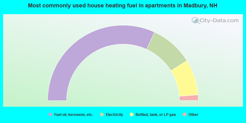
- 63.7%Fuel oil, kerosene, etc.
- 18.5%Electricity
- 15.3%Bottled, tank, or LP gas
- 1.6%Utility gas
- 0.8%Wood
Madbury compared to New Hampshire state average:
- Unemployed percentage significantly below state average.
- Black race population percentage below state average.
- Hispanic race population percentage significantly below state average.
- Renting percentage below state average.
- Length of stay since moving in significantly above state average.
- Number of rooms per house significantly below state average.
- House age significantly below state average.
- Percentage of population with a bachelor's degree or higher above state average.

|
|
Total of 43 patent applications in 2008-2024.